Review

Global Research Trends for Unmanned Aerial Vehicle Remote Sensing Application in Wheat Crop Monitoring

by
Lwandile Nduku
1,2,*,
Cilence Munghemezulu
2,
Zinhle Mashaba-Munghemezulu
2,
Ahmed Mukalazi Kalumba
3,
George Johannes Chirima
1,2,
Wonga Masiza
2 and
Colette De Villiers
1,2
1
Department of Geography, Geoinformatics & Meteorology, University of Pretoria, Pretoria 0028, South Africa
2
Geoinformation Science Division, Agricultural Research Council, Institute for Natural Resources and Engineering, Pretoria 0001, South Africa
3
GACCES Lab, Department of Geography & Environmental Science, University of Fort Hare, Alice 5700, South Africa
*
Author to whom correspondence should be addressed.
Geomatics 2023, 3(1), 115-136; https://doi.org/10.3390/geomatics3010006
Submission received: 20 December 2022 / Revised: 8 January 2023 / Accepted: 13 January 2023 / Published: 25 January 2023

Abstract

:
Wheat is an important staple crop in the global food chain. The production of wheat in many regions is constrained by the lack of use of advanced technologies for wheat monitoring. Unmanned Aerial Vehicles (UAVs) is an important platform in remote sensing for providing near real-time farm-scale information. This information aids in making recommendations for monitoring and improving crop management to ensure food security. This study appraised global scientific research trends on wheat and UAV studies between 2005 and 2021, using a bibliometric method. The 398 published documents were mined from Web of Science, Scopus, and Dimensions. Results showed that an annual growth rate of 23.94% indicates an increase of global research based on wheat and UAVs for the surveyed period. The results revealed that China and USA were ranked as the top most productive countries, and thus their dominance in UAVs extensive usage and research developments for wheat monitoring during the study period. Additionally, results showed a low countries research collaboration prevalent trend, with only China and Australia managing multiple country publications. Thus, most of the wheat- and UAV-related studies were based on intra-country publications. Moreover, the results showed top publishing journals, top cited documents, Zipf’s law authors keywords co-occurrence network, thematic evolution, and spatial distribution map with the lack of research outputs from Southern Hemisphere. The findings also show that “UAV” is fundamental in all keywords with the largest significant appearance in the field. This connotes that UAV efficiency was important for most studies that were monitoring wheat and provided vital information on spatiotemporal changes and variability for crop management. Findings from this study may be useful in policy-making decisions related to the adoption and subsidizing of UAV operations for different crop management strategies designed to enhance crop yield and the direction of future studies.

1. Introduction

Wheat (Triticum aestivum) is one of the most important staple crops that contribute extensively to global food security [1,2,3]. It provides 20% of human food calories worldwide [4,5]. These food calories are commonly found in wheat products such as bread, cereal, rusks, biscuits, pasta, cookies, noodles, and others [6]. Wheat is planted in more than 120 countries across Asia, Europe, America, Africa, and Australia/Oceania [3,7]. The estimated planted area of wheat was 220.83 million hectares (ha) worldwide in 2020/21, which makes it the most widely grown crop, compared to 199.11 million ha of maize and 165.22 million ha of rice [8,9]. Recent reports show that annual global wheat production is approximately 775.71 million metric tons for 2020–2021, this is an increase of approximately 12.34 million metric tons from the 2019–2020 records [3,8,9]. The biggest contributors to global wheat production include Asia, Europe, America, India, and Russia; minor contributors include Africa and Australia [3,10,11,12]. The inevitable increase in the world population puts pressure and more demand on the wheat production industry. Based on its global significance and lack of research studies using UAVs for wheat monitoring, it makes an interesting research topic. Hence, continuous research and development are needed for the wheat crop, especially in developing countries.
The fluctuation in annual wheat production has a negative impact on food security [12] and gaps exist in the knowledge of wheat growth performances, which can enable timeous inventions when needed. The wheat planting calendar is different worldwide, as the seasons are not the same, which causes different planting and harvesting periods. For instance, when majority of wheat is planted in the northern hemisphere, it is contrariwise and harvested in the majority regions of the southern hemisphere [3]. In terms of crop monitoring, there will be variations in the timing of phenological stages of the wheat, which affects the creation of global wheat distribution maps. Therefore, near and real-time monitoring of the spatiotemporal variability in wheat production and growth is necessary to provide accurate information and ensure global food security. Variables such as crop yield, soil parameters (moisture, nutrient, pH), and crop biophysical parameters (canopy cover, Leaf Area Index—LAI, chlorophyll, nitrogen content) need to be monitored for the optimal wheat growth [13,14]. Factors that affect wheat production, including inconsistent weather patterns, climate variability, prevalent droughts, heat stress, and low precipitation, need to be mitigated timeously to enhance wheat production [3,15,16]. Thus, UAV usage enhance farm management practices in terms of identifying appropriate timing for different agricultural operations such as weed management, fertilization, cultivar selection, and irrigation-scheduling for optimal wheat production [17]. Adverse socio-economic factors and socio-economic transformations in the agricultural industry such as the withdrawal of government incentives have contributed to a decline in wheat production, especially in the developing world (e.g., Northern State of Sudan, India, and South Africa) need to be identified and improved [18,19,20,21]. Hence, spatial information on the temporal variability of wheat production as well as soil parameters are useful for monitoring and forecasting wheat production to improve food security.
Remote sensing technologies are vital to the understanding of spatiotemporal changes in crop growth at the intra-field level to improve agricultural production using smart farming and precision agriculture approaches [14,22,23]. Unmanned aerial vehicles are emerging rapidly amongst remote sensing tools suitable for mapping and modeling spatiotemporal changes in wheat crop parameters [24,25,26,27]. Subsequently, UAVs have been investigated for a range of applications on wheat farms including estimations of grain yields and protein content [28]. Furthermore, the use of UAVs has been investigated for applications focusing on wheat health status, vigor, nutrient content, water stress, and disease condition [29,30,31]. Other studies have used UAVs for wheat irrigation management, spraying wheat aphids, pests, and disease control [32,33,34,35]. The advantages of UAVs are that they provide a synoptic view, reduce the costs of using vehicles and handheld sensors, and have a short revisit image acquisition period [13,36,37]. Additionally, they offer payload options, have an ultra-high spatial resolution, and have the ability to fly on cloudy days with minimal atmospheric effects for crop monitoring applications [13,36,37]. Furthermore, UAVs reduce the tedious, time-consuming laboratory experiments and costly field investigation for crop mapping and modeling [38]. Consequently, UAVs has been a suitable technique for near real-time decision-making in smart farming and precision agriculture.
The development of UAVs is a key tool in precision agriculture and is still in its early stages in different regions of the world. However, there is a lack of research that assembles and documents these trajectories for specific crops such as wheat. Therefore, a systematic review evaluating its historical application and trends in wheat crop monitoring provides perspectives about the technology’s adoption, successes, and application globally. The purpose of this study was to provide the comprehensive evolutionary research trends of UAV application in monitoring wheat based on the streamlined published research documents that accommodate the niche area. Accordingly, improvements in the use of this technology could be promoted to ensure sustainable developments. A bibliometric investigation as a systematic and statistical method was performed, which provides an informative and objective scientific analysis of current research hotspots and future directions in a specific niche area [14,39,40,41]. This study assessed published scientific research outputs for annual scientific production, the spatial distribution of productive countries outputs, relevant journals, core sources, top global cited documents, authors keywords’ co-occurrence networks, and thematic evolution of wheat and UAV studies retrieved from 2005–2021. The fundamentals of this study are to provide a global overview of the practical use of UAVs to monitor wheat crop and identify other feasible research topics for current and future wheat and UAV studies. Furthermore, we are contributing to the literature benefiting wheat crop management interventions that ensure food security in precision agriculture.

2. UAV Systems

2.1. UAV Data Acquisition

Several UAV systems are used for data acquisition during surveys. However, the most frequently UAVs that have been used in the previous studies included hexacopters as the highest with 30%, followed by quadcopters, fixed-wings, and octocopters with nearly 25%, 24%, and 19%, respectively [42]. Most studies in precision agriculture have preferred multi-rotor UAVs to monitor wheat crops in small-scale and commercial farms [22,43,44,45]. The UAVs are designed to have payload capacity for different sensors such as thermal sensors, hyperspectral sensors, multispectral sensors, and visible light (RGB) sensors. These sensors provide a crucial role in capturing high-spatial and temporal resolution images that help in monitoring different crop parameters. Recent studies have used all four different common sensors in monitoring wheat crop parameters (Table 1). Thermal imagery from UAVs has shown the potential to predict biomass and grain yields of wheat genotypes grown under water stress areas using machine learning [15,46]. RGB visible spectrum UAV images and deep learning approach integration have been used to build a model for the estimation of wheat above-ground biomass [47]. UAV-based multispectral imaging has demonstrated an ability to monitor leaf nitrogen content and grain protein content in wheat crops [44]. Spectral data collected from UAV hyperspectral images have been used to create a model predicting in-season genetic variations for cellular membrane thermostability, grain yield, and other traits in wheat [16]. Consequently, all these sensors can be used for monitoring wheat parameters.

2.2. UAV Data Processing Tools

Image pre-processing is a crucial and time-consuming step after UAV data acquisition. The purpose of UAV data pre-processing includes correcting distortion of multispectral bands, orthorectification, mosaicking all single images captured in each flight, and computing vegetation indices (VIs) [13,51]. However, image processing requires large computer storage, high-speed internet, and data analytics expertise for accelerating the analysis process. Most studies have used different ways to pre-process UAV data for various crops in precision agriculture [52,53,54]. For instance, Castaldi et al. [52] applied the Support Vector Machine algorithm, Deng et al. [53] used PixelWrench 2 software and Agisoft Photoscan professional software package, and Kawamura et al. [54] used Agisoft metashape software.
Table 2 presents the most common software tools used in the literature to process UAV imagery for wheat crop monitoring. This software relies on different methods to generate surface reflectance maps for each spectral band in the visible or near infrared electromagnetic spectrum. The generated spectral band reflectance maps are very important to compute VIs that monitor crop growth variations. The literature survey recommends that Pix4D software is the optimum processing tool for UAV imagery among other software tools [46,55].

2.3. UAV Application on Wheat Crop Parameters

UAV data can be used for estimating different wheat crop parameters using different UAV systems and sensor types (Table 3). The variety of applications aim at improving crop health and allowing farmers to take corrective measures. The application of UAV hyperspectral sensors seems relatively low compared to multispectral. This can be attributed to the cost of the hyperspectral systems being too high compared to the multispectral sensors, which are relatively more affordable.
Above-Ground Biomass (AGB) is closely related to crop yield, therefore, in-season estimates of AGB can be used to improve farm management practices to optimize crop yield [66]. Yue et al. [67] evaluated VIs and found that textures from ultrahigh-ground-resolution images are closely related to wheat AGB. Additionally, their study found that the combined use of textures and VIs are optimal instead of using these products independently. Moreover, high AGB values during the reproductive growth stages can be estimated accurately with their proposed method.
Nitrogen content can be estimated from UAV data, and this nutrient is crucial for crop growth and the quality of crops [68]. Liu et al. [69] observed a lack of studies using UAV-based hyperspectral remote sensing in precision agriculture. The study by Liu et al. [69] found that the predicted wheat leaf nitrogen content values have a high accuracy during the jointing stage, flagging leaf stage, and flowering stage, but are less accurate in the filling stage. Soil moisture is important for hydrothermal energy exchange, mitigating climate change, and land carbon uptake [70]. Ren et al. [49] observed that previous studies focused on exploring the relationship between soil moisture and soil properties using the partial least squares regression models based on reflectance. The study by Ren et al. [49] investigated the relationships between soil moisture and spectral indices derived from the red-edge or NIR wavelength. Findings from the study indicate that the red-edge band are more sensitive to the soil moisture during the jointing and flowering stages. However, their sensitivity decreased with increasing water stress.
Soil properties influence crop growth and yield. Goffart et al. [50], Webb et al. [71], and Křížová et al. [72] used the conditional inference (CI)-forest algorithm and machine learning algorithms to map the spatial distribution of soil properties with UAV imagery. The framework developed in the study contributes to better management of fertilizer inputs by identifying soil properties that need site-specific management. Water stress can be estimated with UAVs, and this phenomenon limits wheat growth and yield. Das et al. [30] observed a lack of studies on the use of UAV thermal imaging and machine learning techniques to predict crop growth and yield, which aids in identifying cultivars tolerant to sodic soil constraints. The study developed a thermal imaging and classification and regression tree machine learning-based methodological tool that improves understanding of genotypic performance under variable water stress on different sodic soils. Findings from that study suggest that the period close to flowering is a suitable time to identify water stress on crops and is also used to identify wheat cultivars that are tolerant to sodic soil constraints.
Table 3. Different types of UAV systems used in wheat crop applications.
UAV NamesSensor TypeApplicationsCountryReferences
DJI Matrice 100 QuadcopterRGBBiomass estimationBrazil[6,26,47]
Six-rotor DJI S1000 UAV system450–950 nm at 4 nm sampling intervalYellow rust disease modellingChina[3,12,55,73]
AZUP-T8 eight-propeller UAV450–950 nmLAI modellingChina[13,74]
Six-rotary wing UAV Matrice 600 Pro; DJI Phantom 4D RTKRGB; MultispectralWheat lodging and mappingUSA[26,31,75,76]
eBee SQ UAV fixed wing; eBee UAVMultispectralNitrogen mappingChina [26,31,69,77]
DJI Phantom 4 Pro multi-rotorRGBWheat foliage disease severityUSA[12,34,78]
md4-1000 multi-rotorRGBVegetation coverSpain[13,79]
Falcon 8 octocopterMultispectralCrop density estimatesGermany[13,56]
3DR Solo
Multi-rotor
MultispectralPlanting row detectionChina[15,53]
Dajiang Four Rotor MultispectralMultispectralSoil moisture estimationChina[27,50,60,80]
QuadcopterRGBNitrogen status
of wheat
India[44,61,81]
DJI Matrice 600 ProMultispectralWheat yieldUkraine[16,26,48,82]
AscTec Falcon 8MultispectralHigh-throughput phenotyping in wheatMexico[29,62,83]
DJI Phantom 3 Standard quadcopterRGBPlant and water stress in winter wheatPakistan[15,57]
DJI Matrice 600 Pro hexacopter drone; Quadrotor DJI Matrice 100Multispectral + thermalWater stress; evapotranspirationAustralia; Denmark[15,30,58]
Specialized Unmanned Aerial Vehicle (SUAV) sense Flye eBee AgMultispectralLAI, fraction of Absorbed Photosynthetically Active Radiation (fAPAR), fraction of vegetation cover (fCover)Bulgaria[84]
Most of the studies utilizing UAV systems to monitor wheat are based in developed countries (i.e., USA, Germany, and Australia), while a small number of studies came from developing countries such as Brazil, Ukraine, Mexico, India, Philippines, and Pakistan, among others (Table 3). Interestingly, China is the only developing country that is catching up with the rapid UAV trends in wheat research. It is worth noting that developing countries are still far behind on the rapidly evolving UAV trends usage because of the estimated billions of dollars in UAV investment [85]. For instance, most developing countries are still using cost-effective and relatively old UAV systems (i.e., DJI Matrice 100 quadcopter) and cameras to monitor wheat. Meanwhile, developed countries are one step forward with the usage of vastly improved newer UAVs (i.e., DJI Matrice 600 Pro hexacopter) and specifications (weight, endurance, payload, range, wingspan, and flight altitude) over time based on user interest. These UAV specifications play an important role in monitoring wheat. For instance, reduced flight battery limitation and enhanced data-processing speed for large fields [86]. The global aerospace industry reveals the usage of UAVs is still emerging for several developing countries, thus prevalent research in multiple fields is central to developed countries [85,86]. As the technology and resources become available to developing counties [87], it is expected that the use of UAV systems for wheat crop monitoring will improve and contribute to food security. It is not clear the criteria used to select the UAV systems and sensors. However, it appears that the type of application is the main factor contributing towards sensor selection. For example, a thermal sensor is required for water stress and evapotranspiration studies. Meanwhile, multispectral and hyperspectral sensors are mostly used for biophysical and biochemical parameter modeling. The projected UAV trends are likely to be integrated into the harvesting decisions of smart farming, due to the fast growth in UAV technology.

3. Data Collection and Methods

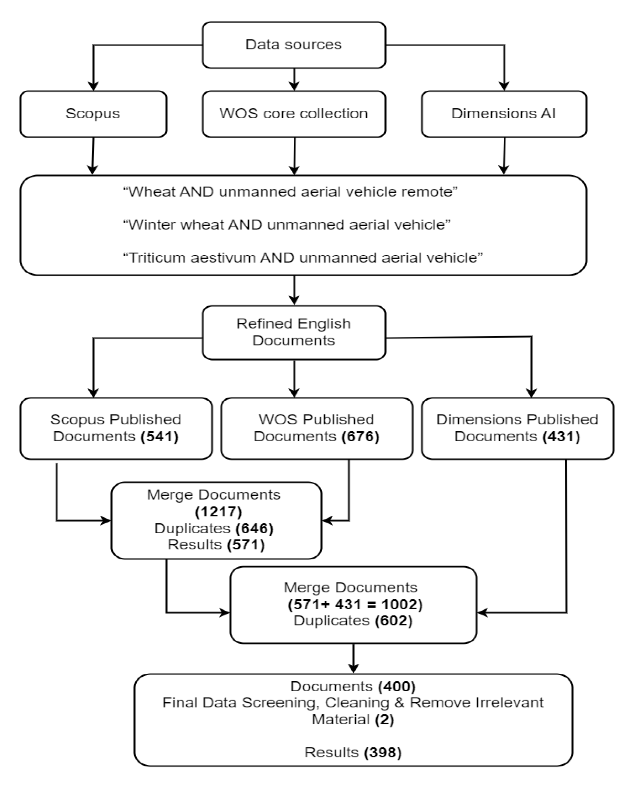
3.1. Bibliometric Study Design

The current study uses three databases to assemble comprehensive scientific literature dataset for bibliometric analysis. The Web of Science (WOS), Scopus, and Dimensions databases were systematically mined for this study on 5 and 11 May 2022. WOS and Scopus are the most widely used bibliometric databases, as they are the only large bibliometric data sources dated more than 15 years [88]. However, recent bibliometric databases such as Dimensions are seen as the alternative with extensive scientific research documents [89]. In addition, these databases are widely acknowledged for their high scientific impact and comprehensive research coverage [90]. Most studies have used these three databases separately for bibliometric analysis due to difficulties and a time-consuming data cleaning process. For instance, similar studies in the niche areas of wheat, remote sensing, and UAV application have only used the WOS database for exploring bibliometric analysis trends [91,92]. The above three databases were integrated into the current study. The information in Figure 1 shows the selection criteria for wheat and UAV studies appraised and selected for bibliometric analysis.

3.2. Bibliometric Data Processing

The study retrieved all the publications in wheat and UAV research using these search terms: “wheat AND unmanned aerial vehicle remote”, “winter wheat AND unmanned aerial vehicle”, and “Triticum aestivum AND unmanned aerial vehicle”, based in the document titles, abstract, and keywords from 2005 to 2021. The Boolean operation AND was used to combined search terms. The retrieved documents were refined to 541, 676, and 431 articles, conference papers, conference reviews, reviews and book chapters from databases. Furthermore, the Zotero software (Version 6.0.7) tool was used to collate the total and merge the 1648 bibliographic records of all retrieved documents in the databases [89,93]. Documents were processed for data cleaning, screening, and removing duplicates using both Zotero [94] and R-software [39]. All the bibliometric analysis results were carried out using open-source software such as R-Studio (v4.0.4), biblioshiny, or VOSviewer software (v1.6.16), which provide an interactive bibliometrix web interface [39,94,95,96].

4. Results

4.1. Characteristics of WOS, Scopus, and Dimensions of Science Indexed Databases

This study presents a bibliometric analysis of 398 published document types (articles, conference papers, conference reviews, reviews, and book chapters) retrieved from Dimensions, Scopus, and WOS databases. All the investigated documents were streamlined to accommodate the niche study area. The summary of the information extracted from these databases is presented in Table 4. The documents had a total of 1251 authors, while 1251 authors contributed to multi-authored documents with a collaboration index of 3.23 and 6 authors wrote single-authored documents. The authors’ keywords were clustered into 1071 authors’ keywords (ID) and 447 authors’ keywords (DE) in the field of wheat and UAV studies [97,98]. In addition, the 165 sources evaluated (journals, books, etc.) involve 2018 authors’ appearances with 0.317 documents per author (3.16 authors per document) and 5.58 co-authors per document. The study has an average annual percentage growth of 20.49% in citations per document recorded during the survey period.

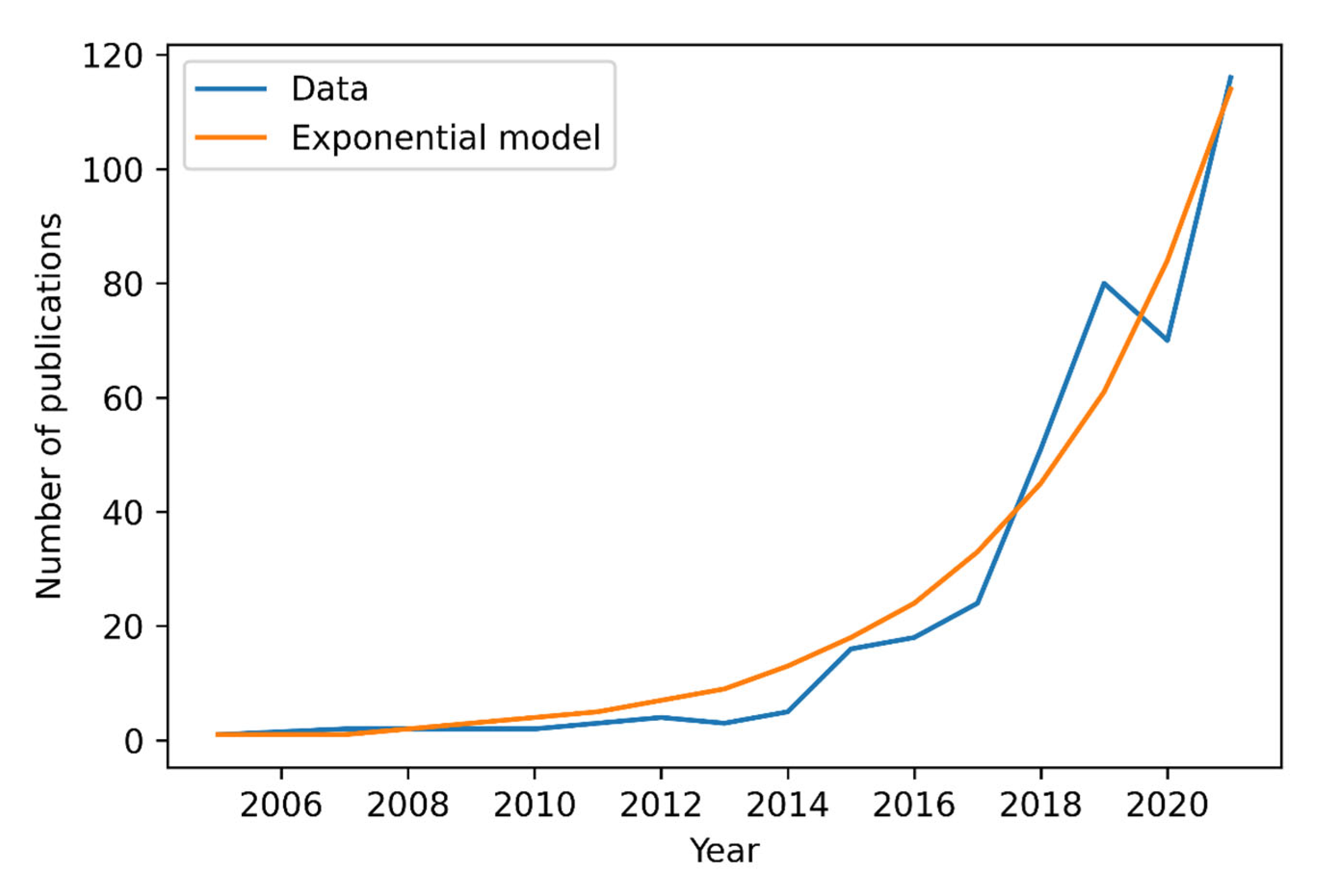
4.2. Historical and Current Trend of Scientific Contribution per Document

The historical annual research production rate was low compared to recent years based on the number of documents recorded from 2005 to 2021 (Figure 2). However, a rapid increasing trend in document production rate started from 2015 to 2018. This could be indicative of more organizations gaining access to UAV technologies and an increase in research outputs. A prominent decreasing trend was observed in 2020, while the publication trend peaked in 2019 and 2021. It is worth noting that the study has witnessed an inconsistency over the past three years of maintaining the same growth trend of publications. However, the study conformed to Price’s law of bibliometrics based on the exponential annual scientific production growth [99]. This exponential scientific production growth was witnessed from 2005 to 2019 and 2020 to 2021. The study observed 23.94% annual growth in wheat and UAV studies for the year 2021. This indicates that the field of research was developing for wheat and UAV studies. Therefore, annual growth signifies the emerging interest of research institutions for potential UAV uses in managing and monitoring wheat.

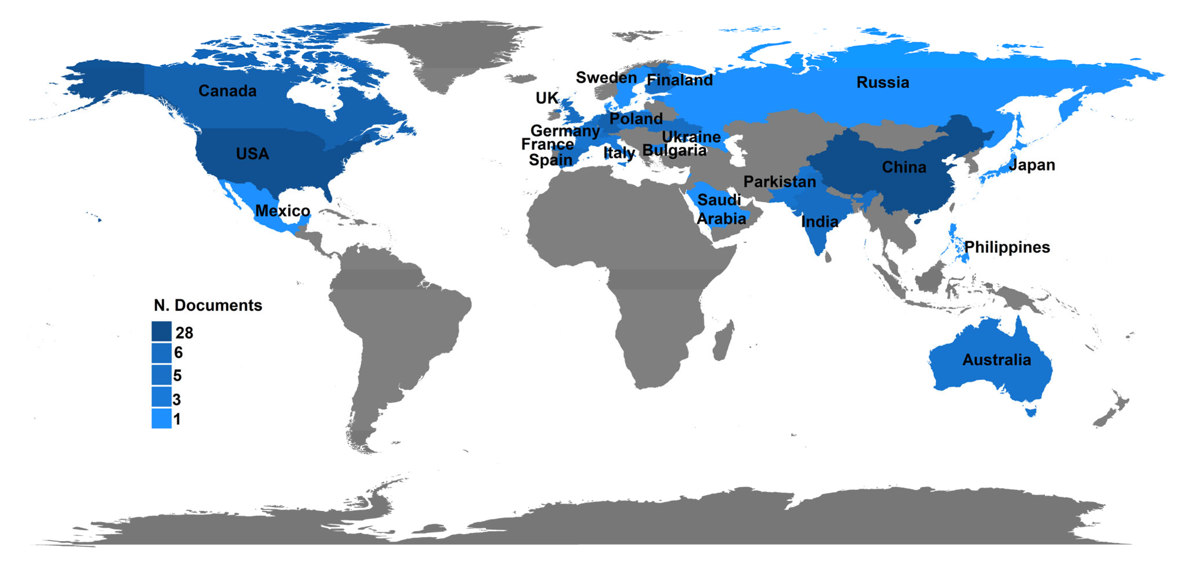
4.3. Spatial Distribution and Most Global Cited Scientific Research Contributions per Country

The contributions of different countries to wheat and UAV studies were analyzed from 2005 to 2021 [100]. Table 5 shows the top 10 most productive countries and their percentage in the total scientific production (TCP), which includes the following: total citations (TC); average document citations (ADC); single country publications (SCP); and multiple country publications (MCP). These indicators reflect the research success and academic authority of a country. The number of documents identified for wheat and UAV studies is very few. Based on these numbers, China has contributed 28 documents, accounting for 7% of the TCP, while the USA produced only 11, and Germany only 9 documents, accounting for 2.8% and 2.3% of the TCP, respectively, during the survey period. Furthermore, low research outputs and single country publications were observed in Italy, Denmark, Finland, and other countries. The TC and ADC are other indicators of the influence that a country has in the research field. The top four most cited countries were the USA (TC = 545 and ADC = 49.55), followed by Spain (TC = 417 and ADC = 69.50), Finland (TC = 388 and ADC = 129.33), and China (TC = 352 and ADC = 12.57), respectively. This study acknowledges the limitation of bibliometrics in terms of quantified citation analysis highlighted in previous studies using multiple databases [101,102,103]. The results show that most of the publications were completed by only one country, and only China and Australia were involved in multi-national publications.
In relation to countries’ contributions, Figure 3 shows the spatial distribution of the documents published on wheat and UAV-related studies from 2005 to 2021. The distribution observed from this map indicates that Australia is the only country in the southern hemisphere that has published research in this field. Developing nations in Sub-Saharan Africa such as Ethiopia and South Africa are valuable producers of the wheat crop [104]. However, most developing nations in Africa were expected to have contributed to wheat production, but they have poor research outputs. This can be attributed to the high cost associated with UAV technology and regulations that limit the publication of research documents.

4.4. Temporal Journals Analysis

The number of journal sources that have published wheat- and UAV-related work was 165, which includes document types such as articles, conference papers, conference reviews, reviews, and book chapters. Table 6 summarizes the journal sources that have published six or more documents in the niche area of study. Remote sensing is the top-ranked journal with the most published scientific outputs (n = 76, 19.09%). The second and third journals in the ranking are the Computers and Electronics in Agriculture journal and the Frontiers in Plant Science journal, which have published a total number of 19 (4.77%) and 17 (4.27%) documents, respectively. However, the sixth to eighth place ranked journals produced below twelve documents, indicating that the top five journals are the most widely disseminating journals for documents published on wheat and UAV research. The impact factor varied in all the journal sources, and most of them were classified under quartile 1, which is the top ranking. The top selected journal sources with their number of documents per journal conform to Bradford’s law. Bradford’s law indicates that that the dissemination of scientific production associated with a particular subject is unequal, and a relatively small number of journal sources publish a large number, reaching one-third of the total documents [105]. Furthermore, a large number of journal sources have a common number of publications.

4.5. Summary of Top Global Most Cited Published Documents on Wheat and UAV Research

Table 7 provides a summary of the top globally cited published documents on wheat and UAV studies selected during the survey period. The study selected top globally cited documents based on the citation ranking for research performance analysis [106]. In Finland, the researchers implemented a processing methodology for a UAV-mounted hyperspectral sensor and investigated its applicability in wheat biomass estimation [107]. They used the K-Nearest Neighbor algorithm and different radiometric processing techniques for biomass estimation. The authors found that radiometric correction had an influence on the accuracy of biomass estimation. For radiometrically uncorrected and corrected data, they achieved normalized mean root square errors (NRMSEs) of 26.2% and 20.4%, respectively. They achieved NRMSEs of 15.5%, 17.3%, and 24.4% when using data pre-processed with radiometric block adjustment and in situ irradiance measurements. In the final analysis, there was a recommendation for the use of multivariate statistical techniques for the identification of more suitable spectral bands and spectral indices [107].
In the USA, a study correlated LAI with green normalized difference vegetation index (GNDVI) derived from a UAV-based NIR-green-blue digital camera [108]. The study observed that GDNVI was consistently linearly related with a correlation of 85% with wheat LAI when the LAI was less than 2.7. At an LAI of above 2.7, GNDVI was not sensitive to the changes in LAI. The relationship between LAI and GNDVI was better when images were collected at 210 m than at 105 m. The authors recommended that more research was needed to discriminate between leaf chlorophyll and LAI-caused GNDVI variations. In Spain, another study investigated the influence of flight altitude and the number of days after sowing on a UAV-mounted camera’s ability to map vegetation fraction in a wheat field [13]. Among the different VIs compared in this study, the excess green index achieved the highest classification accuracy (91.99%) at 30 m flight altitude followed by the vegetative index (91.81%). These two indices produced the best classification results independent of the image acquisition date. However, the authors observed that classification accuracy was influenced by flight altitude, with an average accuracy reduction of 3.95% when flight altitude was increased from 30 m to 60 m. In the final analysis, the authors recommended the use of their method for early season mapping of wheat rows and detection of weeds.
In France, researchers used UAV-based visible and near infrared sensors to monitor different varieties of wheat [100]. They achieved this by relating different VIs including NDVI, soil adjusted vegetation index (SAVI), GI, and GNDVI with ground-based measurements of biophysical parameters including LAI and nitrogen uptake. A strong correlation of 82% was obtained between the LAI and NDVI, and also, between nitrogen uptake and GNDVI, a correlation of 92% was observed. However, date-specific correlations between these parameters were not as good. In the final analysis, the authors observed that improvements could be made by shifting the locations of the spectral bands and through reflectance recalibration. The study by Sankaran [109] reviewed state-of-the-art UAV-based imaging sensors and their capabilities for phenotyping of field crops. The study reported that plant water stress, nutrient deficiency, heat stress, plant emergence, vigor, LAI, biomass, yield potential, and plant height are some of the parameters that can be measured with UAV-based spectral indices and visible, NIR, and TIR data. Although UAV-based sensors have been used for identifying and monitoring diseases, remote sensing of disease severity and susceptibility of different varieties to diseases is still underdeveloped. The authors also reported that, while UAV operation is often constrained by sensor payload, operating altitude, and flight time, data processing such as image blur and geometric corrections, image stitching, georeferencing, and automated feature extraction need to be improved.
In the UK, crop height and crop growth rate retrieval from multi-temporal data recorded through structure from motion by a high-resolution UAV-mounted camera were investigated [110]. Although crop height was underestimated in some instances, the authors found that the data could generally retrieve crop height with accuracy of more than 93%, with an RMSE of 0.077 m. The authors concluded that the RMSE values achieved in this study meant that crop growth rate could be derived from the multi-temporal surface models produced from this dataset. They also found that variables such as canopy structure and plant density influenced the results. In the final analysis, the study recommended further exploration of the camera viewing angle and incorporation of NIR imagery for improved results. However, in 2018 there was a review on the progress made with UAV-based remote sensing of drought stress, weeds and pathogens, nutrient status, growth vigor, and crop yields [37]. They observed that UAV-based remote sensing of drought stress focused more on orchards than on field crops. Furthermore, the authors noted that the application of multispectral imagery for early detection of plant infections had produced mixed results with false negative observations, while hyperspectral sensing of infections had not been widely explored with UAVs. In the final analysis, the study emphasized the need to use UAV-based data in robust radiative transfer and crop growth models rather than in empirical and linear regression models.
Other researchers have used a UAV-based RGB sensor, flown at low altitude and low speed, to estimate plant density of winter wheat at emergence [111]. They employed object classification by training support vector machines with plant number-related image objects. The study obtained a range of RMSEs between 21.66 and 52.35 plants/m2 under variable conditions and observed that the estimation accuracy decreased as plant density increased. In the final analysis, they recommended 0.40 mm and a higher spatial resolution for estimating wheat plant density. In Spain, researchers used UAV-mounted visible and multispectral sensors and an object-based method to classify vegetation over wheat, maize, and sunflower crop fields [112]. They found that object size affected the classification accuracies because classification error was low when the object size was nearly the average plant size in the image. For instance, in wheat plots, they found that classification error was minimal when the scale parameter was equal to one pixel because of the small sizes of wheat plants. In contrast, shape and compactness parameters exhibited minor influence on classification accuracy. In the final analysis, the object-based image analysis algorithm implemented in the study produced classification accuracies with errors ranging between 0 and 10%.
In China, researchers combined UAV-based snapshot hyperspectral (UHD 185) and crop height data to estimate above-ground biomass (AGB) of winter wheat [113]. They first correlated AGB with UHD 185 and ASD reflectance and found high correlations in the 462 to 720 nm region, and low correlations in the 750 to 882 nm region. Spectral bands and VIs that had stronger and significant correlations with AGB were B470, G550, R670, and NIR800, ratio vegetation index, NDVI, and wide dynamic range vegetation index. These variables were then used in conjunction with crop height data in different regression models to estimate AGB of wheat. The authors found that the combination of spectral and crop height data improved AGB estimation. By incorporating crop height data, the correlation increased from 54–59% to 71–76%, while RMSEs decreased from 1.47–1.55 tons per hectare (t/ha) to 1.12–1.22 t/ha. Model performances improved even further with different combinations of VIs and spectral bands, achieving a maximum correlation of 78% and RMSE of 1.08 t/ha.
Table 7. Top 10 globally cited published documents on wheat and UAV studies from 2005–2021.
RankDocument TitleTCTC per YearReferences
1Processing and Assessment of Spectrometric, Stereoscopic Imagery Collected Using a Lightweight UAV Spectral Camera for Precision Agriculture35335.300[107]
2Acquisition of NIR-Green-Blue Digital Photographs from Unmanned Aircraft for Crop Monitoring31724.385[108]
3Multi-Temporal Mapping of the Vegetation Fraction in Early-Season Wheat Fields using Images from UAV29632.889[13]
4Assessment of Unmanned Aerial Vehicles Imagery for Quantitative Monitoring of Wheat Crop in Small Plots27518.333[100]
5Low-Altitude, High-Resolution Aerial Imaging Systems for Row and Field Crop Phenotyping: A Review24530.625[109]
6Perspectives for Remote Sensing with Unmanned Aerial Vehicles in Precision Agriculture21754.250[37]
7High Throughput Field Phenotyping of Wheat Plant Height and Growth Rate in Field Plot Trials Using UAV Based Remote Sensing21430.571[110]
8Estimates of Plant Density of Wheat Crops at Emergence from Very Low Altitude UAV Imagery20834.667[111]
9An Automatic Object-Based Method for Optimal Thresholding in UAV Images: Application for Vegetation Detection in Herbaceous Crops18523.125[112]
10Estimation of Winter Wheat Above-Ground Biomass Using Unmanned Aerial Vehicle-Based Snapshot Hyperspectral Sensor and Crop Height Improved Models17328.833[113]

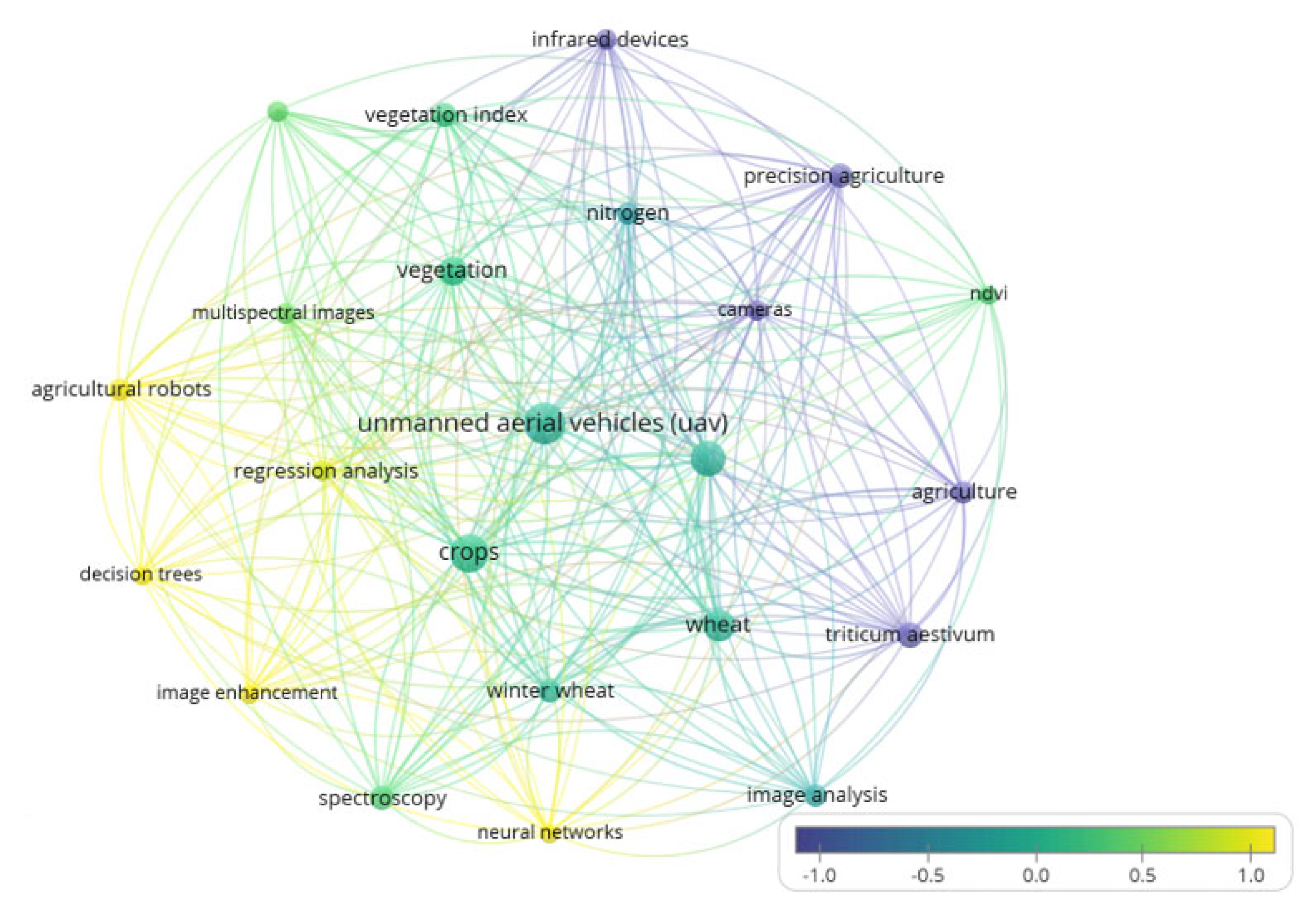
4.6. Authors’ Keywords and Co-Occurrence Network

The selected authors’ keywords co-occurrence network in wheat and UAV studies are presented into clusters and nodes, which show the frequency of authors’ keywords (Figure 4). The selection of the number of authors’ keywords was based on Zipf’s law. In addition, lines between nodes indicate the strength and relationship of the clusters. However, bigger nodes such as UAV, crops, and wheat suggest the higher frequency of authors’ keywords and their significance in wheat and UAV studies toward precision agriculture. The nitrogen fertilizer was the most considered and monitored wheat parameter estimation used in authors’ keywords during the survey period. Furthermore, common tools such as cameras, infrared devices, and field spectroscopy for data acquisition appeared in keywords. The prevalent methods were neural networks, decision trees, agricultural robots, and vegetation index such as NDVI for authors’ keywords. However, big data, machine learning, artificial intelligence, soil parameters (moisture, pH, soil nutrients, properties), crop parameters (crop density, canopy, LAI, plant height, AGB), and other VIs were not visible in the authors’ keywords, suggesting low frequency or little attention given in terms of research. Therefore, future studies can navigate towards investigating these crucial factors in characterization of wheat using UAVs.

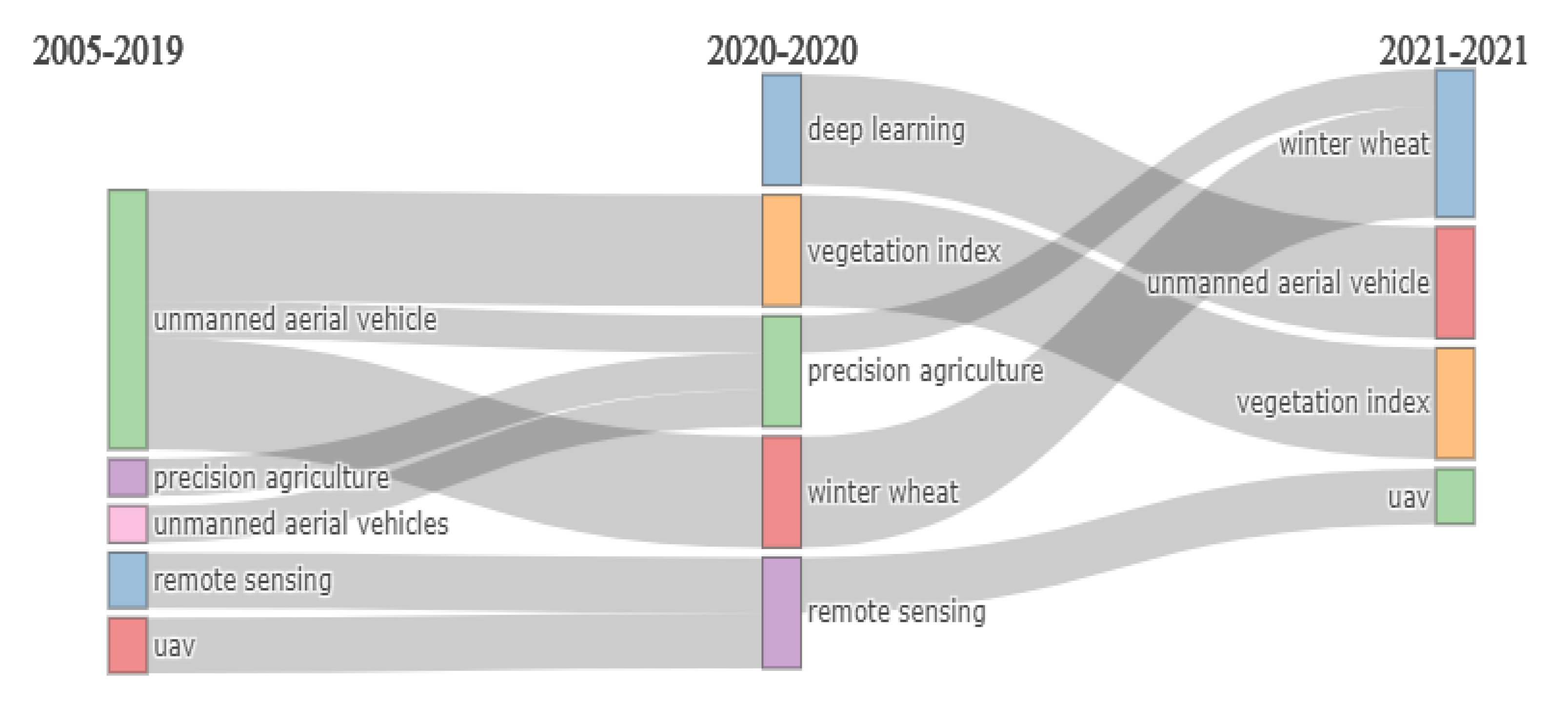
4.7. Authors’ Keywords Thematic Evolution

The thematic evolution presents developments of focal research areas in a specific field of study over time. Accordingly, authors’ keywords were used to evaluate thematic progress on wheat and UAV published documents (Figure 5). The results revealed that the unmanned aerial vehicles and precision agriculture have been stable themes used by authors from 2005 to 2020. In addition, deep learning and vegetation index became prevalent themes in 2020, although they did not progress in the wheat and UAV research domain. The study witnessed unmanned aerial vehicles and precision agriculture focused on winter wheat in 2021 based on high frequency authors’ keyword during the survey period.

5. Discussion

The study aim was to review the trends of research and technology adoption focusing on wheat and UAVs. The trends were revealed through a bibliometric analysis of annual scientific production, productive countries’ outputs, top global cited published documents, core sources, authors’ keyword co-occurrence networks, and thematic evolution of authors’ keywords in wheat and UAV studies. The findings from the current study show that the annual scientific production trend in wheat and UAV studies peaked in around 2019, and in 2021, with an overall growth rate of 20.49% in citation per document. The annual scientific production growth rate was 23.94%, suggesting that global research on wheat and UAV studies has been increasing during the survey period. Consequently, there has been a realization of wheat importance in the global market and UAV systems are becoming affordable, so many research institutes can afford these types of technologies for research developments. There has been an increasing application of UAVs to monitor wheat crop growth and dynamics at a broad spatial, temporal, and near real-time farm-scale [14,35].
The results revealed that China, USA, Germany, and Australia ranked as the most productive countries in terms of publications and total citations. Similar findings have revealed that USA, China, Australia, and Germany have been leading countries in terms of publication contributions [91]. This may be linked to countries’ wheat production, where China is the leading wheat producer, followed by USA in the fourth position (after India and Russia) [5,9,114]. The research developments in China and USA may explain their efforts for global wheat production, as they are part of the top four current wheat producers with India and Russia [3,5,8]. In addition, China and USA are the leading countries with UAV applications to monitor different crops in precision agriculture, which may support their top ranking for the current study [23]. China primarily uses UAVs in precision agriculture over conventional agricultural monitoring methods [115]. This may explain why China has more research outputs in wheat and UAV studies.
The spatial distribution map revealed low global research output with no records in some parts of North America, Europe, Asia, South America, and Africa in wheat and UAV studies during the survey period. The low global annual research publications on wheat and UAV studies cannot be generalized in terms of countries’ publications. However, the high cost of UAVs with compatible cameras, limited licensed pilot experts, certificate of authorization acquisition, and aviation regulations may be linked with the low global research output in monitoring wheat [116,117,118,119]. The lack of research outputs in wheat and UAV-related studies based on Africa can be associated to its low level of initial adoption over past years [95,112,120]. Moreover, the results revealed that China and Australia are the only countries with multiple-country publications. Consequently, it is evident that countries still lack collaborations to strengthen research partnerships in wheat and UAV studies to alleviate food security challenges. This suggests a motivation for countries’ collaboration to increase research funding and counteract the high cost of UAV application to monitor wheat and increase research outputs. The advancement in grant funding is crucial to strengthen research productivity [40,121]. Other countries including North China, USA, Australia, and Germany have adopted the UAV-associated approach in monitoring their crop farming systems [122]. This may be extended to other developing countries to accelerate the low global research output in wheat and UAV studies.
The study observed that the journals Remote Sensing and Computers and Electronics in Agriculture are in a central position in all publishing journal sources of wheat and UAV studies evaluated. This suggests that, with their high impact factor and global influence, the journals can strengthen research developments in this niche area [123]. However, most journals have published research on “wheat and UAV”, but the current study evaluates relevant journal on WOS, Scopus, and Dimensions databases. The study further revealed “UAV” and “wheat” were the highest frequency authors’ keywords appearing in the field of wheat and UAV studies. This demonstrates the contribution of remote sensing application and synergy between UAVs and wheat [66,124]. Results further revealed that “cameras”, “infrared devices”, and “field spectroscopy” appeared in high frequency for authors’ keywords and play important roles to monitor wheat parameters such as biomass, chlorophyll, LAI, and nitrogen content in wheat and UAV studies [47,67,68]. The keywords “neural networks”, “decision trees”, and “NDVI” have contributed to monitoring and modelling wheat parameters based on their appearance in authors’ keywords during the survey period. NDVI is the most used VI and indicator to monitor wheat growth in farmlands [38,100,125]. This index is a good to contrast between the vegetation and the soil in monitoring winter wheat AGB [38,67]. Furthermore, it is worth noting that the winter wheat, UAVs, and vegetation index are current themes within the niche area of the study. For instance, the recent studies on wheat and UAV research have published within the scope of the above themes [5,15,24,27,29,61,64,66,67,69,71,78,79,112,125]. This may suggest a research direction in the field of wheat and UAV studies. However, there is still limited research focus exploring the use of space-borne and UAV imagery fusion for agricultural applications, particularly in wheat research [126,127]. Despite this, there has been recent development of spatio-temporal fusion (STF) framework on UAV and satellite imagery for continuous winter wheat growth monitoring [126]. Thus, future studies are strongly recommended to consider STF framework to accelerate research developments in the niche area of the study.

6. Conclusions

This study reviewed the trends of research and technology adoption focusing on wheat and UAVs, using a bibliometric method from 2005 to 2021, to provide a comprehensive evolution and understanding of current research hotspots. Findings from the research reveal that studies focusing on wheat and UAVs have been increasing during the study period. However, developed countries that produce large quantities of wheat are using UAV technologies more than developing countries. This trend is similar for research outputs and top global cited documents. The main findings are associated with the efficiency of UAVs to monitor and provide important information about crop variability at near real-time for instant crop management. This study will help government corporation and agricultural institutions bolster their realization, implementation, adaptation, and integration of recent technologies to improve crop management strategies for high-yielding crops and meet global market. Therefore, findings from this study are vital for optimizing farming practices in crop production with evolving research developments that shed light on the low-ranking authors’ keywords with those countries that had little or no research on wheat and UAV studies and provide hints for future research. The study limitations involved complex assembling of multiple databases and data fusion. This paper show potentials of the applied methods in the current study, and other research databases should be integrated to reveal more possible research developments within the niche area of the study.

Author Contributions

Conceptualization, L.N., C.M., and Z.M.-M.; methodology and data pre-processing, L.N.; writing—original draft preparation, L.N., Z.M.-M., W.M., and C.D.V.; writing—review and editing, C.M., G.J.C., A.M.K., Z.M.-M., and W.M.; supervision, G.J.C., C.M., A.M.K., and W.M. All authors have read and agreed to the published version of the manuscript.

Funding

This research was funded by the Council for Scientific and Industrial Research (CSIR) and the Department of Science and Innovation (DSI). Research support from the Agricultural Research Council-Natural Resources and Engineering (ARC-NRE), University of Pretoria and National Research Foundation (NRF) (grant number: TTK200221506319), and the South African National Space Agency (SANSA) are acknowledged.

Institutional Review Board Statement

Not applicable.

Informed Consent Statement

Not applicable.

Data Availability Statement

Data used in this study are available on request. Requests for access to these data should be made to Cilence Munghemezulu, munghemezuluc@arc.agric.za.

Acknowledgments

The authors would like to thank the Agricultural Research Council ARC-NRE and University of Pretoria for creating an enabling environment for research.

Conflicts of Interest

The authors declare no conflict of interest.

References

  1. Shiferaw, B.; Smale, M.; Braun, H.J.; Duveiller, E.; Reynolds, M.; Muricho, G. Crops That Feed the World 10. Past Successes and Future Challenges to the Role Played by Wheat in Global Food Security. Food Secur. 2013, 5, 291–317. [Google Scholar] [CrossRef] [Green Version]
  2. Francesconi, S.; Harfouche, A.; Maesano, M.; Balestra, G.M. UAV-Based Thermal, RGB Imaging and Gene Expression Analysis Allowed Detection of Fusarium Head Blight and Gave New Insights into the Physiological Responses to the Disease in Durum Wheat. Front. Plant Sci. 2021, 12, 628575. [Google Scholar] [CrossRef]
  3. Erenstein, O.; Jaleta, M.; Mottaleb, K.A.; Sonder, K.; Donovan, J.; Braun, H.J. Global Trends in Wheat Production, Consumption and Trade. In Wheat Improvement; Reynolds, M.P., Braun, H.-J., Eds.; Springer International Publishing: Cham, Switzerland, 2022; pp. 47–66. [Google Scholar] [CrossRef]
  4. Mitchell, D.O.; Mielke, M. Wheat: The global market, policies, and priorities. In Global Agricultural Trade and Developing Countries; World Bank: Washington, DC, USA, 2005; pp. 195–214. [Google Scholar]
  5. Wu, X.; Xiao, X.; Steiner, J.; Yang, Z.; Qin, Y.; Wang, J. Spatiotemporal Changes of Winter Wheat Planted and Harvested Areas, Photosynthesis and Grain Production in the Contiguous United States from 2008–2018. Remote Sens. 2021, 13, 1735. [Google Scholar] [CrossRef]
  6. Alvarez, J.B.; Guzmán, C. Interspecific and Intergeneric Hybridization as a Source of Variation for Wheat Grain Quality Improvement. Theor. Appl. Genet. 2018, 131, 225–251. [Google Scholar] [CrossRef]
  7. FAOStat. Food and Agriculture Organization of the United Nation Statistics. 2020. Available online: http://www.fao.org/faostat (accessed on 25 May 2022).
  8. United State Department Agriculture (USDA) Foreign Agricultural Service (FAS). World Agricultural Production. Circular Series WAP. 2020; pp. 4–22. Available online: https://www.fas.usda.gov/data/world-agricultural-production (accessed on 3 May 2022).
  9. United State Department Agriculture (USDA) Foreign Agricultural Service (FAS). World Agricultural Production. Circular Series WAP. 2022; pp. 7–22. Available online: https://www.fas.usda.gov/data/world-agricultural-production (accessed on 4 August 2022).
  10. Pronin, D.; Börner, A.; Weber, H.; Scherf, K.A. Wheat (Triticum aestivum L.) Breeding from 1891 to 2010 Contributed to Increasing Yield and Glutenin Contents but Decreasing Protein and Gliadin Contents. J. Agric. Food Chem. 2020, 68, 13247–13256. [Google Scholar] [CrossRef]
  11. Liebenberg, I.; De Wet, F. Food Security, Wheat Production and Policy in South Africa: Reflections on Food Sustainability and Challenges for a Market Economy. J. Transdiscipl. Res. South. Afr. 2018, 14, 1–11. [Google Scholar] [CrossRef] [Green Version]
  12. Petronaitis, T.; Simpfendorfer, S.; Hüberli, D. Importance of Fusarium spp. in Wheat to Food Security: A Global Perspective. In Plant Diseases and Food Security in the 21st Century; Scott, P., Strange, R., Korsten, L., Gullino, M.L., Eds.; Springer International Publishing: Cham, Switzerland, 2021; pp. 127–159. [Google Scholar] [CrossRef]
  13. Torres-Sánchez, J.; Pena, J.M.; de Castro, A.I.; López-Granados, F. Multi-Temporal Mapping of the Vegetation Fraction in Early-Season Wheat Fields Using Images from UAV. Comput. Electron. Agric. 2014, 103, 104–113. [Google Scholar] [CrossRef]
  14. Singh, A.P.; Yerudkar, A.; Mariani, V.; Iannelli, L.; Glielmo, L. A Bibliometric Review of the Use of Unmanned Aerial Vehicles in Precision Agriculture and Precision Viticulture for Sensing Applications. Remote Sens. 2022, 14, 1604. [Google Scholar] [CrossRef]
  15. Antoniuk, V.; Manevski, K.; Kørup, K.; Larsen, R.; Sandholt, I.; Zhang, X.; Andersen, M.N. Diurnal and Seasonal Mapping of Water Deficit Index and Evapotranspiration by an Unmanned Aerial System: A Case Study for Winter Wheat in Denmark. Remote Sens. 2021, 13, 2998. [Google Scholar] [CrossRef]
  16. Costa, L.; McBreen, J.; Ampatzidis, Y.; Guo, J.; Gahrooei, M.R.; Babar, M.A. Using UAV-Based Hyperspectral Imaging and Functional Regression to Assist in Predicting Grain Yield and Related Traits in Wheat under Heat-Related Stress Environments for the Purpose of Stable Yielding Genotypes. Precis. Agric. 2022, 23, 622–642. [Google Scholar] [CrossRef]
  17. Al-Feel, M.A.; AL-Basheer, A.A.R. Economic Efficiency of Wheat Production in Gezira Scheme, Sudan. J. Saudi Soc. Agric. Sci. 2012, 11, 1–5. [Google Scholar] [CrossRef] [Green Version]
  18. Jha, S.; Srinivasan, P.V.; Landes, M.R. Indian Wheat and Rice Sector Policies and the Implications of Reform. USDA-ERS Economic Research Report 2007. No. 41. Available online: https://ssrn.com/abstract=1084557 (accessed on 20 May 2022).
  19. Elsheikh, O.E.; Elbushra, A.A.; Salih, A.A. Economic Impacts of Changes in Wheat’s Import Tariff on the Sudanese Economy. J. Saudi Soc. Agric. Sci. 2015, 14, 68–75. [Google Scholar] [CrossRef]
  20. Meyer, F.H.; Davids, T.; Westhuizen, D.; Gouse, M.; Burgh, G.; Delport, M.; Trapnell, L. Assessment of the Drivers Inluencing Wheat Producing in South Africa. Bureau for Food and Agriculture Policy (BFAP), University of Pretoria, Conference. 2015. Available online: https://www.researchgate.net/publication/317332694_An_assessment_of_the_drivers_influencing_wheat_production_in_South_Africa (accessed on 28 May 2022).
  21. Musa, A.I.; Tsubo, M.; Ali-Babiker, I.E.A.; Iizumi, T.; Kurosaki, Y.; Ibaraki, Y.; Tsujimoto, H. Relationship of Irrigated Wheat Yield with Temperature in Hot Environments of Sudan. Theor. Appl. Climatol. 2021, 145, 1113–1125. [Google Scholar] [CrossRef]
  22. Mogili, U.R.; Deepak, B.B.V.L. Review on Application of Drone Systems in Precision Agriculture. Procedia Comput. Sci. 2018, 133, 502–509. [Google Scholar] [CrossRef]
  23. Tsouros, D.C.; Bibi, S.; Sarigiannidis, P.G. A Review on UAV-Based Applications for Precision Agriculture. Information 2019, 10, 349. [Google Scholar] [CrossRef] [Green Version]
  24. Lu, N.; Wang, W.; Zhang, Q.; Li, D.; Yao, X.; Tian, Y.; Cheng, T. Estimation of Nitrogen Nutrition Status in Winter Wheat from Unmanned Aerial Vehicle Based Multi-Angular Multispectral Imagery. Front. Plant Sci. 2019, 10, 1601. [Google Scholar] [CrossRef] [Green Version]
  25. Boursianis, A.D.; Papadopoulou, M.S.; Diamantoulakis, P.; Liopa-Tsakalidi, A.; Barouchas, P.; Salahas, G.; Goudos, S.K. Internet of Things (IoT) and Agricultural Unmanned Aerial Vehicles (UAVs) in Smart Farming: A Comprehensive Review. Internet Things 2022, 18, 100187. [Google Scholar] [CrossRef]
  26. Astaoui, G.; Dadaiss, J.E.; Sebari, I.; Benmansour, S.; Mohamed, E. Mapping Wheat Dry Matter and Nitrogen Content Dynamics and Estimation of Wheat Yield Using UAV Multispectral Imagery Machine Learning and a Variety-Based Approach: Case Study of Morocco. AgriEngineering 2021, 3, 29–49. [Google Scholar] [CrossRef]
  27. Guo, J.; Bai, Q.; Guo, W.; Bu, Z.; Zhang, W. Soil Moisture Content Estimation in Winter Wheat Planting Area for Multi-Source Sensing Data Using CNNR. Comput. Electron. Agric. 2022, 193, 106670. [Google Scholar] [CrossRef]
  28. Zhou, X.; Kono, Y.; Win, A.; Matsui, T.; Tanaka, T.S. Predicting Within-Field Variability in Grain Yield and Protein Content of Winter Wheat Using UAV-Based Multispectral Imagery and Machine Learning Approaches. Plant Prod. Sci. 2021, 24, 137–151. [Google Scholar] [CrossRef]
  29. Song, Y.; Wang, J. Winter Wheat Canopy Height Extraction from UAV-Based Point Cloud Data with a Moving Cuboid Filter. Remote Sens. 2019, 11, 1239. [Google Scholar] [CrossRef] [Green Version]
  30. Das, S.; Christopher, J.; Apan, A.; Choudhury, M.R.; Chapman, S.; Menzies, N.W.; Dang, Y.P. Evaluation of Water Status of Wheat Genotypes to Aid Prediction of Yield on Sodic Soils Using UAV-Thermal Imaging and Machine Learning. Agric. For. Meteorol. 2021, 307, 108477. [Google Scholar] [CrossRef]
  31. Zhang, X.; Han, L.; Sobeih, T.; Lappin, L.; Lee, M.A.; Howard, A.; Kisdi, A. The Self-Supervised Spectral–Spatial Vision Transformer Network for Accurate Prediction of Wheat Nitrogen Status from UAV Imagery. Remote Sens. 2022, 14, 1400. [Google Scholar] [CrossRef]
  32. Quebrajo, L.; Perez-Ruiz, M.; Pérez-Urrestarazu, L.; Martínez, G.; Egea, G. Linking Thermal Imaging and Soil Remote Sensing to Enhance Irrigation Management of Sugar Beet. Biosyst. Eng. 2018, 165, 77–87. [Google Scholar] [CrossRef]
  33. Ahansal, Y.; Bouziani, M.; Yaagoubi, R.; Sebari, I.; Sebari, K.; Kenny, L. Towards Smart Irrigation: A Literature Review on the Use of Geospatial Technologies and Machine Learning in the Management of Water Resources in Arboriculture. Agronomy 2022, 12, 297. [Google Scholar] [CrossRef]
  34. Meng, Y.; Lan, Y.; Mei, G.; Guo, Y.; Song, J.; Wang, Z. Effect of Aerial Spray Adjuvant Applying on the Efficiency of Small Unmanned Aerial Vehicle for Wheat Aphids Control. Int. J. Agric. Biol. Eng. 2018, 11, 5432–5452. [Google Scholar]
  35. Wang, G.; Lan, Y.; Qi, H.; Chen, P.; Hewitt, A.; Han, Y. Field Evaluation of an Unmanned Aerial Vehicle (UAV) Sprayer: Effect of Spray Volume on Deposition and the Control of Pests and Disease in Wheat. Pest Manag. Sci. 2019, 75, 1546–1555. [Google Scholar] [CrossRef]
  36. Stroppiana, D.; Villa, P.; Sona, G.; Ronchetti, G.; Candiani, G.; Pepe, M.; Boschetti, M. Early Season Weed Mapping in Rice Crops Using Multi-Spectral UAV Data. Int. J. Remote Sens. 2018, 39, 5432–5452. [Google Scholar] [CrossRef]
  37. Maes, W.H.; Steppe, K. Perspectives for Remote Sensing with Unmanned Aerial Vehicles in Precision Agriculture. Trends Plant Sci. 2019, 24, 152–164. [Google Scholar] [CrossRef]
  38. Li, C.; Li, H.; Li, J.; Lei, Y.; Li, C.; Manevski, K.; Shen, Y. Using NDVI Percentiles to Monitor Real-Time Crop Growth. Comput. Electron. Agric. 2019, 162, 357–363. [Google Scholar] [CrossRef]
  39. Aria, M.; Cuccurullo, C. Bibliometrix: An R-Tool for Comprehensive Science Mapping Analysis. J. Informetr. 2017, 11, 959–975. [Google Scholar] [CrossRef]
  40. Nduku, L.; Kalumba, A.M.; Munghemezulu, C.; Mashaba-Munghemezulu, Z.; Chirima, G.J.; Afuye, G.A.; Busayo, E.T. Earth Observation Systems and Pasture Modeling: A Bibliometric Trend Analysis. ISPRS Int. J. Geo-Inf. 2021, 10, 793. [Google Scholar] [CrossRef]
  41. Rejeb, A.; Abdollahi, A.; Rejeb, K.; Treiblmaier, H. Drones in Agriculture: A Review and Bibliometric Analysis. Comput. Electron. Agric. 2022, 198, 107017. [Google Scholar] [CrossRef]
  42. Eskandari, R.; Mahdianpari, M.; Mohammadimanesh, F.; Salehi, B.; Brisco, B.; Homayouni, S. Meta-Analysis of Unmanned Aerial Vehicle (UAV) Imagery for Agro-Environmental Monitoring Using Machine Learning and Statistical Models. Remote Sens. 2020, 12, 3511. [Google Scholar] [CrossRef]
  43. Shakhatreh, H.; Sawalmeh, A.H.; Al-Fuqaha, A.; Dou, Z.; Almaita, E.; Khalil, I.; Guizani, M. Unmanned Aerial Vehicles (UAVs): A Survey on Civil Applications and Key Research Challenges. IEEE Access 2019, 7, 48572–48634. [Google Scholar] [CrossRef]
  44. Fu, Z.; Yu, S.; Zhang, J.; Xi, H.; Gao, Y.; Lu, R.; Liu, X. Combining UAV Multispectral Imagery and Ecological Factors to Estimate Leaf Nitrogen and Grain Protein Content of Wheat. Eur. J. Agron. 2022, 132, 126405. [Google Scholar] [CrossRef]
  45. Stewart, M.; Martin, S. Unmanned Aerial Vehicles: Fundamentals, Components, Mechanics, and Regulations; Nova Science Publishers: Hauppauge, NY, USA, 2021. [Google Scholar]
  46. Das, S.; Chapman, S.; Christopher, J.; Choudhury, M.R.; Menzies, N.W.; Apan, A.; Dang, Y.P. UAV-Thermal Imaging: A Technological Breakthrough for Monitoring and Quantifying Crop Abiotic Stress to Help Sustain Productivity on Sodic Soils—A Case Review on Wheat. Remote Sens. Appl. Soc. Environ. 2021, 23, 100583. [Google Scholar] [CrossRef]
  47. Schreiber, L.V.; Atkinson Amorim, J.G.; Guimarães, L.; Motta Matos, D.; Maciel da Costa, C.; Parraga, A. Above-Ground Biomass Wheat Estimation: Deep Learning with UAV-Based RGB Images. Appl. Artif. Intell. 2022, 36, 2055392. [Google Scholar] [CrossRef]
  48. Liu, W.; Cao, X.; Fan, J.; Wang, Z.; Yan, Z.; Luo, Y.; Zhou, Y. Detecting Wheat Powdery Mildew and Predicting Grain Yield Using Unmanned Aerial Photography. Plant Dis. 2018, 102, 1981–1988. [Google Scholar] [CrossRef] [Green Version]
  49. Ren, S.; Guo, B.; Wang, Z.; Wang, J.; Fang, Q.; Wang, J. Optimized Spectral Index Models for Accurately Retrieving Soil Moisture (SM) of Winter Wheat under Water Stress. Agric. Water Manag. 2022, 261, 107333. [Google Scholar] [CrossRef]
  50. Goffart, D.; Dvorakova, K.; Crucil, G.; Curnel, Y.; Limbourg, Q.; Van Oost, K.; Castaldi, F.; Planchon, V.; Goffart, J.P.; van Wesemael, B. UAV Remote Sensing for Detecting Within-Field Spatial Variation of Winter Wheat Growth and Links to Soil Properties and Historical Management Practices. A Case Study on Belgian Loamy Soil. Remote Sens. 2022, 14, 2806. [Google Scholar] [CrossRef]
  51. Jhan, J.P.; Rau, J.Y.; Haala, N. Robust and Adaptive Band-to-Band Image Transform of UAS Miniature Multi-Lens Multispectral Camera. ISPRS J. Photogramm. Remote Sens. 2018, 137, 47–60. [Google Scholar] [CrossRef]
  52. Castaldi, F.; Pelosi, F.; Pascucci, S.; Casa, R. Assessing the Potential of Images from Unmanned Aerial Vehicles (UAV) to Support Herbicide Patch Spraying in Maize. Precis. Agric. 2017, 18, 76–94. [Google Scholar] [CrossRef]
  53. Deng, L.; Mao, Z.; Li, X.; Hu, Z.; Duan, F.; Yan, Y. UAV-Based Multispectral Remote Sensing for Precision Agriculture: A Comparison between Different Cameras. ISPRS J. Photogramm. Remote Sens. 2018, 146, 124–136. [Google Scholar] [CrossRef]
  54. Kawamura, K.; Asai, H.; Yasuda, T.; Soisouvanh, P.; Phongchanmixay, S. Discriminating Crops/Weeds in an Upland Rice Field from UAV Images with the SLIC-RF Algorithm. Plant Prod. Sci. 2021, 24, 198–215. [Google Scholar] [CrossRef]
  55. Su, J.; Liu, C.; Chen, W.H. UAV Multispectral Remote Sensing for Yellow Rust Mapping: Opportunities and Challenges. In Unmanned Aerial Systems in Precision Agriculture; Zhang, Z., Liu, H., Yang, H., Ampatzidis, Y., Zhou, J., Jiang, Y., Eds.; Springer Nature: Singapore, 2022; pp. 107–122. [Google Scholar] [CrossRef]
  56. Wilke, N.; Siegmann, B.; Postma, J.A.; Muller, O.; Krieger, V.; Pude, R.; Rascher, U. Assessment of Plant Density for Barley and Wheat Using UAV Multispectral Imagery for High-Throughput Field Phenotyping. Comput. Electron. Agric. 2021, 189, 106380. [Google Scholar] [CrossRef]
  57. Mazhar, N.; Shirazi, S.A.; Stringer, L.C.; Manzoor, S. Using UAV imagery to measure plant and water stress in winter wheat fields of drylands, south Punjab, Pakistan. Pak. J. Agric. Sci. 2021, 58, 1041–1050. [Google Scholar]
  58. Murphy, M.E.; Boruff, B.; Callow, J.N.; Flower, K.C. Detecting Frost Stress in Wheat: A Controlled Environment Hyperspectral Study on Wheat Plant Components and Implications for Multispectral Field Sensing. Remote Sens. 2020, 12, 477. [Google Scholar] [CrossRef] [Green Version]
  59. Mozgeris, G.; Jonikavičius, D.; Jovarauskas, D.; Zinkevičius, R.; Petkevičius, S.; Steponavičius, D. Imaging from Manned Ultra-Light and Unmanned Aerial Vehicles for Estimating Properties of Spring Wheat. Precis. Agric. 2018, 19, 876–894. [Google Scholar] [CrossRef]
  60. Hassan-Esfahani, L.; Torres-Rua, A.; Jensen, A.; McKee, M. Assessment of Surface Soil Moisture Using High-Resolution Multi-Spectral Imagery and Artificial Neural Networks. Remote Sens. 2015, 7, 2627–2646. [Google Scholar] [CrossRef] [Green Version]
  61. Zheng, H.; Li, W.; Jiang, J.; Liu, Y.; Cheng, T.; Tian, Y.; Yao, X. A Comparative Assessment of Different Modeling Algorithms for Estimating Leaf Nitrogen Content in Winter Wheat Using Multispectral Images from an Unmanned Aerial Vehicle. Remote Sens. 2018, 10, 2026. [Google Scholar] [CrossRef] [Green Version]
  62. Khan, Z.; Rahimi-Eichi, V.; Haefele, S.; Garnett, T.; Miklavcic, S.J. Estimation of Vegetation Indices for High-Throughput Phenotyping of Wheat Using Aerial Imaging. Plant Methods 2018, 14, 20. [Google Scholar] [CrossRef] [Green Version]
  63. Gnädinger, F.; Schmidhalter, U. Digital Counts of Maize Plants by Unmanned Aerial Vehicles (UAVs). Remote Sens. 2021, 9, 221–237. [Google Scholar]
  64. Das, S.; Christopher, J.; Apan, A.; Choudhury, M.R.; Chapman, S.; Menzies, N.W.; Dang, Y.P. UAV-Thermal Imaging and Agglomerative Hierarchical Clustering Techniques to Evaluate and Rank Physiological Performance of Wheat Genotypes on Sodic Soil. ISPRS J. Photogramm. Remote Sens. 2021, 173, 221–237. [Google Scholar]
  65. Wang, J.J.; Ge, H.; Dai, Q.; Ahmad, I.; Dai, Q.; Zhou, G.; Gu, C. Unsupervised Discrimination between Lodged and Non-Lodged Winter Wheat: A Case Study Using a Low-Cost Unmanned Aerial Vehicle. Int. J. Remote Sens. 2018, 39, 2079–2088. [Google Scholar] [CrossRef]
  66. Huang, J.; Sedano, F.; Huang, Y.; Ma, H.; Li, X.; Liang, S.; Tian, L.; Zhang, X.; Fan, J.; Wu, W. Assimilating a Synthetic Kalman Filter Leaf Area Index Series into the WOFOST Model to Improve Regional Winter Wheat Yield Estimation. Agric. For. Meteorol. 2016, 216, 188–202. [Google Scholar] [CrossRef]
  67. Yue, J.; Yang, G.; Tian, Q.; Feng, H.; Xu, K.; Zhou, C. Estimate of Winter-Wheat Above-Ground Biomass Based on UAV Ultrahigh-Ground-Resolution Image Textures and Vegetation Indices. ISPRS J. Photogramm. Remote Sens. 2019, 150, 226–244. [Google Scholar] [CrossRef]
  68. Vitousek, P.M.; Hättenschwiler, S.; Olander, L.; Allison, S. Nitrogen and Nature. AMBIO J. Hum. Environ. 2002, 31, 97–101. [Google Scholar] [CrossRef]
  69. Liu, H.; Zhu, H.; Wang, P. Quantitative Modelling for Leaf Nitrogen Content of Winter Wheat Using UAV-Based Hyperspectral Data. Int. J. Remote Sens. 2017, 38, 2117–2134. [Google Scholar] [CrossRef]
  70. Humphrey, V.; Berg, A.; Ciais, P.; Gentine, P.; Jung, M.; Reichstein, M.; Seneviratne, S.I.; Frankenberg, C. Soil Moisture–Atmosphere Feedback Dominates Land Carbon Uptake Variability. Nature 2021, 592, 65–69. [Google Scholar] [CrossRef]
  71. Webb, H.; Barnes, N.; Powell, S.; Jones, C. Does Drone Remote Sensing Accurately Estimate Soil PH in a Spring Wheat Field in Southwest Montana? Precis. Agric. 2021, 22, 1803–1815. [Google Scholar] [CrossRef]
  72. Křížová, K.; Haberle, J.; Kroulík, M.; Kumhálová, J.; Lukáš, J. Assessment of Soil Electrical Conductivity Using Remotely Sensed Thermal Data. Agron. Res. 2018, 16, 3. [Google Scholar] [CrossRef]
  73. Schotten, M.; Meester, W.J.; Steiginga, S.; Ross, C.A. A brief history of Scopus: The world’s largest abstract and citation database of scientific literature. In Research Analytics; Auerbach Publications: Farnham, UK, 2017. [Google Scholar] [CrossRef]
  74. Zheng, Q.; Huang, W.; Ye, H.; Dong, Y.; Shi, Y.; Chen, S. Using Continous Wavelet Analysis for Monitoring Wheat Yellow Rust in Different Infestation Stages Based on Unmanned Aerial Vehicle Hyperspectral Images. Appl. Opt. 2020, 59, 8003. [Google Scholar] [CrossRef]
  75. Zhang, J.; Cheng, T.; Guo, W.; Xu, X.; Qiao, H.; Xie, Y.; Ma, X. Leaf Area Index Estimation Model for UAV Image Hyperspectral Data Based on Wavelength Variable Selection and Machine Learning Methods. Plant Methods 2021, 17, 49. [Google Scholar] [CrossRef]
  76. Zhao, B.; Li, J.; Baenziger, P.S.; Belamkar, V.; Ge, Y.; Zhang, J.; Shi, Y. Automatic Wheat Lodging Detection and Mapping in Aerial Imagery to Support High-Throughput Phenotyping and In-Season Crop Management. Agronomy 2020, 10, 1762. [Google Scholar] [CrossRef]
  77. Zhang, Z.; Flores, P.; Igathinathane, C.; Naik, D.L.; Kiran, R.; Ransom, J.K. Wheat Lodging Detection from UAS Imagery Using Machine Learning Algorithms. Remote Sens. 1838, 12, 1838. [Google Scholar] [CrossRef]
  78. Chen, Z.; Miao, Y.; Lu, J.; Zhou, L.; Li, Y.; Zhang, H.; Liu, C. In-Season Diagnosis of Winter Wheat Nitrogen Status in Smallholder Farmer Fields Across a Village Using Unmanned Aerial Vehicle-Based Remote Sensing. Agronomy 2019, 9, 619. [Google Scholar] [CrossRef] [Green Version]
  79. Bhandari, M.; Ibrahim, A.M.; Xue, Q.; Jung, J.; Chang, A.; Rudd, J.C.; Landivar, J. Assessing Winter Wheat Foliage Disease Severity Using Aerial Imagery Acquired from Small Unmanned Aerial Vehicle (UAV). Comput. Electron. Agric. 2020, 176, 105665. [Google Scholar] [CrossRef]
  80. Chen, P.; Ma, X.; Wang, F.; Li, J. A New Method for Crop Row Detection Using Unmanned Aerial Vehicle Images. Remote Sens. 2021, 13, 3526. [Google Scholar] [CrossRef]
  81. Choudhary, S.S.; Biswal, S.; Saha, R.; Chatterjee, C. A Non-Destructive Approach for Assessment of Nitrogen Status of Wheat Crop Using Unmanned Aerial Vehicle Equipped with RGB Camera. Arab. J. Geosci. 2021, 14, 1739. [Google Scholar] [CrossRef]
  82. Shvorov, S.; Lysenko, V.; Pasichnyk, N.; Opryshko, O.; Komarchuk, D.; Rosamakha, Y.; Martsyfei, A. The Method of Determining the Amount of Yield Based on the Results of Remote Sensing Obtained Using UAV on the Example of Wheat. In Proceedings of the 2020 IEEE 15th International Conference on Advanced Trends in Radioelectronics, Telecommunications and Computer Engineering (TCSET), Lviv-Slavske, Ukraine, 25–29 February 2020; pp. 245–248. [Google Scholar] [CrossRef]
  83. Tattaris, M.; Reynolds, M.P.; Chapman, S.C. A Direct Comparison of Remote Sensing Approaches for High-Throughput Phenotyping in Plant Breeding. Front. Plant Sci. 2016, 7, 1131. [Google Scholar] [CrossRef]
  84. Jelev, G.; Dimitrov, P.; Roumenina, E. Within-Field Mapping of Winter Wheat Biophysical Variables Using Multispectral Images from UAV. Aerosp. Res. Bulg. 2022, 34, 13–28. [Google Scholar] [CrossRef]
  85. Battsengel, G.; Geetha, S.; Jeon, J. Analysis of Technological Trends and Technological Portfolio of Unmanned Aerial Vehicle. Journal of Open Innovation: Technology, Market, and Complexity 2020, 6, 48. [Google Scholar] [CrossRef]
  86. Aabid, A.; Parveez, B.; Parveen, N.; Khan, S.A.; Zayan, J.M.; Shabbir, O. Reviews on Design and Development of Unmanned Aerial Vehicle (Drone) for Different Applications. J. Mech. Eng. Res. Dev. 2022, 45, 53–69. [Google Scholar]
  87. Flores, C.C.; Tan, E.; Crompvoets, J. Governance Assessment of UAV Implementation in Kenyan Land Administration System. Technol. Soc. 2021, 66, 101664. [Google Scholar] [CrossRef]
  88. Birkle, C.; Pendlebury, D.A.; Schnell, J.; Adams, J. Web of Science as a Data Source for Research on Scientific and Scholarly Activity. Quant. Sci. Stud. 2020, 1, 363–376. [Google Scholar] [CrossRef]
  89. Hook, D.W.; Porter, S.J.; Herzog, C. Dimensions: Building Context for Search and Evaluation. Front. Res. Metr. Anal. 2018, 3, 23. [Google Scholar] [CrossRef] [Green Version]
  90. Visser, M.; van Eck, N.J.; Waltman, L. Large-Scale Comparison of Bibliographic Data Sources: Scopus, Web of Science, Dimensions. Quant. Sci. Stud. 2021, 2, 20–41. [Google Scholar] [CrossRef]
  91. Yuan, B.Z.; Sun, J. Research Trends and Status of Wheat (Triticum aestivum L.) Based on the Essential Science Indicators during 2010–2020: A Bibliometric Analysis. Cereal Res. Commun. 2021, 50, 335–346. [Google Scholar] [CrossRef]
  92. Siłuch, M.; Bartmiński, P.; Zgłobicki, W. Remote Sensing in Studies of the Growing Season: A Bibliometric Analysis. Remote Sens. 2022, 14, 1331. [Google Scholar] [CrossRef]
  93. Trinoskey, J.; Brahmi, F.A.; Gall, C. Zotero: A Product Review. J. Electron. Resour. Med. Libr. 2009, 6, 224–229. [Google Scholar] [CrossRef]
  94. Van Eck, N.; Waltman, L. Software Survey: VOSviewer, a Computer Program for Bibliometric Mapping. Scientometrics 2010, 84, 523–538. [Google Scholar] [CrossRef] [Green Version]
  95. Van Eck, N.J.; Waltman, L. VOSviewer Manual; Leiden Univeristeit: Leiden, The Netherlands, 2013; pp. 1–53. [Google Scholar]
  96. Cuccurullo, C.; Aria, M.; Sarto, F. Foundations and Trends in Performance Management. A Twenty-Five Years Bibliometric Analysis in Business and Public Administration Domains. Scientometrics 2016, 108, 595–611. [Google Scholar] [CrossRef]
  97. Aria, M. An R-Package to Gather Bibliographic Data from DS Dimenions. ai.dimensionsR: A Brief Example. 7 February 2022. Available online: https://cran.r-project.org/web/packages/dimensionsR/vignettes/A_Brief_Example.html (accessed on 30 May 2022).
  98. Ruiz-Rosero, J.; Ramírez-González, G.; Viveros-Delgado, J. Software Survey: ScientoPy, a Scientometric Tool for Topics Trend Analysis in Scientific Publications. Scientometrics 2019, 121, 1165–1188. [Google Scholar] [CrossRef]
  99. Price, D.D.S. A General Theory of Bibliometric and Other Cumulative Advantage Processes. J. Am. Soc. Inf. Sci. 1976, 27, 292–306. [Google Scholar] [CrossRef] [Green Version]
  100. Lelong, C.C.; Burger, P.; Jubelin, G.; Roux, B.; Labbé, S.; Baret, F. Assessment of Unmanned Aerial Vehicles Imagery for Quantitative Monitoring of Wheat Crop in Small Plots. Sensors 2008, 8, 3557–3585. [Google Scholar] [CrossRef]
  101. Echchakoui, S. Why and How to Merge Scopus and Web of Science during Bibliometric Analysis: The Case of Sales Force Literature from 1912 to 2019. J. Mark. Anal. 2020, 8, 165–184. [Google Scholar]
  102. Agbo, F.J.; Sanusi, I.T.; Oyelere, S.S.; Suhonen, J. Application of Virtual Reality in Computer Science Education: A Systemic Review Based on Bibliometric and Content Analysis Methods. Educ. Sci. 2021, 11, 142. [Google Scholar] [CrossRef]
  103. Martín-Martín, A.; Thelwall, M.; Orduna-Malea, E.; Delgado López-Cózar, E. Google Scholar, Microsoft Academic, Scopus, Dimensions, Web of Science, and OpenCitations’ COCI: A Multidisciplinary Comparison of Coverage via Citations. Scientometrics 2021, 126, 871–906. [Google Scholar] [CrossRef]
  104. Tadesse, W.; Bishaw, Z.; Assefa, S. Wheat Production and Breeding in Sub-Saharan Africa: Challenges and Opportuni-ties in the Face of Climate Change. Int. J. Clim. Change Strateg. Manag. 2019, 11, 696–715. [Google Scholar] [CrossRef] [Green Version]
  105. Bradford, S.C. Sources of Information on Specific Subjects 1934. J. Inf. Sci. 1985, 10, 176–180. [Google Scholar] [CrossRef]
  106. Noyons, E.; Moed, H.; Raan, A.V. Integrating Research Performance Analysis and Science Mapping. Scientometrics 1999, 46, 591–604. [Google Scholar] [CrossRef]
  107. Honkavaara, E.; Saari, H.; Kaivosoja, J.; Pölönen, I.; Hakala, T.; Litkey, P.; Pesonen, L. Processing and Assessment of Spectrometric, Stereoscopic Imagery Collected Using a Lightweight UAV Spectral Camera for Precision Agriculture. Remote Sens. 2013, 5, 5006–5039. [Google Scholar] [CrossRef] [Green Version]
  108. Hunt, E.R., Jr.; Hively, W.D.; Fujikawa, S.J.; Linden, D.S.; Daughtry, C.S.; McCarty, G.W. Acquisition of NIR-Green-Blue Digital Photographs from Unmanned Aircraft for Crop Monitoring. Remote Sens. 2010, 2, 290–305. [Google Scholar] [CrossRef] [Green Version]
  109. Sankaran, S.; Khot, L.R.; Espinoza, C.Z.; Jarolmasjed, S.; Sathuvalli, V.R.; Vandemark, G.J.; Pavek, M.J. Low-Altitude, High-Resolution Aerial Imaging Systems for Row and Field Crop Phenotyping: A Review. Eur. J. Agron. 2015, 70, 112–123. [Google Scholar] [CrossRef]
  110. Holman, F.H.; Riche, A.B.; Michalski, A.; Castle, M.; Wooster, M.J.; Hawkesford, M.J. High Throughput Field Phenotyping of Wheat Plant Height and Growth Rate in Field Plot Trials Using UAV Based Remote Sensing. Remote Sens. 2016, 8, 1031. [Google Scholar] [CrossRef]
  111. Jin, X.; Liu, S.; Baret, F.; Hemerlé, M.; Comar, A. Estimates of Plant Density of Wheat Crops at Emergence from Very Low Altitude UAV Imagery. Remote Sens. Environ. 2017, 198, 105–114. [Google Scholar] [CrossRef] [Green Version]
  112. Torres-Sánchez, J.; López-Granados, F.; Pena, J.M. An Automatic Object-Based Method for Optimal Thresholding in UAV Images: Application for Vegetation Detection in Herbaceous Crops. Comput. Electron. Agric. 2015, 114, 43–52. [Google Scholar] [CrossRef]
  113. Yue, J.; Yang, G.; Li, C.; Li, Z.; Wang, Y.; Feng, H.; Xu, B. Estimation of Winter Wheat Above-Ground Biomass Using Unmanned Aerial Vehicle-Based Snapshot Hyperspectral Sensor and Crop Height Improved Models. Remote Sens. 2021, 9, 708. [Google Scholar] [CrossRef] [Green Version]
  114. Raheem, D.; Dayoub, M.; Birech, R.; Nakiyemba, A. The Contribution of Cereal Grains to Food Security and Sustainability in Africa: Potential Application of UAV in Ghana, Nigeria, Uganda, and Namibia. Urban Sci. 2021, 5, 8. [Google Scholar] [CrossRef]
  115. Haula, K.; Agbozo, E. A Systematic Review on Unmanned Aerial Vehicles in Sub-Saharan Africa: A Socio-Technical Perspective. Technol. Soc. 2020, 63, 101357. [Google Scholar] [CrossRef]
  116. Huajun, T. Progress and Prospect of Agricultural Remote Sensing Research. J. Agric. 2018, 8, 175. [Google Scholar] [CrossRef]
  117. Zhang, H.; Wang, L.; Tian, T.; Yin, J. A Review of Unmanned Aerial Vehicle Low-Altitude Remote Sensing (UAV-LARS) Use in Agricultural Monitoring in China. Remote Sens. 2021, 13, 1221. [Google Scholar] [CrossRef]
  118. Hardin, P.J.; Jensen, R.R. Small-Scale Unmanned Aerial Vehicles in Environmental Remote Sensing: Challenges and Opportunities. GIScience Remote Sens. 2011, 48, 99–111. [Google Scholar] [CrossRef]
  119. Zhang, C.; Kovacs, J.M. The Application of Small Unmanned Aerial Systems for Precision Agriculture: A Review. Precis. Agric. 2012, 13, 693–712. [Google Scholar] [CrossRef]
  120. European Commission. Commission Implementing Regulation (EU) 2019/947 of 24 May 2019 on the rules and procedures for the operation of unmanned aircraft. Off. J. Eur. Union 2019, 152, 40–70. [Google Scholar]
  121. Saygitov, R.T. The Impact of Grant Funding on the Publication Activity of Awarded Applicants: A Systematic Review of Comparative Studies and Meta-Analytical Estimates. Sci. Commun. Educ. 2018, preprint. [Google Scholar] [CrossRef]
  122. Li, W.; Clark, B.; Taylor, J.A.; Kendall, H.; Jones, G.; Li, Z.; Frewer, L.J. A Hybrid Modelling Approach to Understanding Adoption of Precision Agriculture Technologies in Chinese Cropping Systems. Comput. Electron. Agric. 2020, 172, 105305. [Google Scholar] [CrossRef]
  123. Zhang, H.; Huang, M.; Qing, X.; Li, G.; Tian, C. Bibliometric Analysis of Global Remote Sensing Research during 2010–2015. ISPRS Int. J. Geo-Inf. 2017, 6, 332. [Google Scholar] [CrossRef] [Green Version]
  124. Das, S.; Christopher, J.; Apan, A.; Choudhury, M.R.; Chapman, S.; Menzies, N.W.; Dang, Y.P. UAV-Thermal Imaging: A Robust Technology to Evaluate in-Field Crop Water Stress and Yield Variation of Wheat Genotypes. In Proceedings of the 2020 IEEE India Geoscience and Remote Sensing Symposium (InGARSS), Ahmedabad, India, 1–4 December 2020; pp. 138–141. [Google Scholar] [CrossRef]
  125. Mashaba, Z. Modelling Dryland Winter Wheat Yield Using Remotely Sensed Imagery and Agrometeorological Parameters. University of Pretoria. 2017. Available online: https://repository.up.ac.za/handle/2263/60634 (accessed on 29 May 2022).
  126. Zhang, S.; Zhao, G.; Lang, K.; Su, B.; Chen, X.; Xi, X.; Zhang, H. Integrated Satellite, Unmanned Aerial Vehicle (UAV) and Ground Inversion of the SPAD of Winter Wheat in the Reviving Stage. Sensors 2019, 19, 1485. [Google Scholar] [CrossRef] [Green Version]
  127. Li, Y.; Yan, W.; An, S.; Gao, W.; Jia, J.; Tao, S.; Wang, W. A Spatio-Temporal Fusion Framework of UAV and Satellite Imagery for Winter Wheat Growth Monitoring. Drones 2022, 7, 23. [Google Scholar] [CrossRef]
Figure 1. Schematic diagram illustrating criteria for publication selection.
Geomatics 03 00006 g001
Figure 2. Annual scientific production of wheat and UAV studies from 2005–2021, a correlation of more than 90% is observed.
Geomatics 03 00006 g002
Figure 3. Spatial distribution map where UAVs were used in wheat from 2005–2021 (Note: grey colored regions have no data captured).
Geomatics 03 00006 g003
Figure 4. Authors’ keywords co-occurrence network on wheat and UAV studies between the period of 2005–2021.
Geomatics 03 00006 g004
Figure 5. Thematic evolution of authors’ keyword in wheat and UAV studies from 2005–2021.
Geomatics 03 00006 g005
Table 1. Most common sensors in wheat and UAV applications for precision agriculture.
SensorReference
Thermal sensors[2,15,30,46]
RGB[2,13,29,47]
Multispectral sensors[15,24,26,44]
Hyperspectral sensors[16,48,49,50]
Table 2. Common processing imagery software tools used in wheat crop monitoring for precision agriculture.
Software ToolsReference
Pix4Dmapper[2,15,55]
Agisoft Metashape[13,47,56]
Drone Deploy[57,58]
EnsoMOSAIC[59,60]
ENVI/IDL environment[24,30,44,61]
MATLAB[46,62,63]
ERDAS Imagine 2018[48,64]
Adobe Photoshop[63,65]
Table 4. The summary information of WOS, Scopus, and Dimension retrieved on wheat and UAV application studies.
DescriptionResults
Time Span2005–2021
Documents398
Sources (Journals, Books, etc.)165
Keywords Plus (ID)1071
Author’s Keywords (DE)447
Average citations per document20.49
Authors1257
Author Appearances2018
Authors of Multi-Authored Documents1251
Single-Authored Documents6
Documents per Author0.317
Authors per Document3.16
Co-Authors per Documents5.58
Annual Growth per Documents23.94
Collaboration Index3.23
Document Types
Article329
Conference Paper50
Conference Review6
Review3
Book Chapter2
Table 5. Top 10 most productive and cited countries per average document citation on wheat and UAV studies from 2005–2021.
RankCountryTCP (%)TCADCSCPMCP
1China7%35212.57253
2USA2.8%54549.55110
3Germany2.3%15617.3390
4Australia1.5%10617.6761
5Spain1.5%41769.5060
6United Kingdom1.3%6112.2050
7Canada1%276.7540
8Italy1%389.5040
9Denmark0.8%124.0030
10Finland0.8%388129.3330
Note: total scientific production (TCP); total citations (TC); average document citations (ADC); single country publications (SCP); multiple country publications (MCP).
Table 6. Top journals on wheat and UAV studies from 2005–2021.
RankSourcesNIF of JCR (WoS) IF of SJR (Scopus)
1Remote Sensing765.349 (Q1)1.283(Q1)
2Computer and Electronics in Agriculture196.757(Q1)1.6(Q1)
3Frontiers in Plant Science176.627 (Q1)1.36(Q1)
4Sensors163.847 (Q2)0.8(Q1)
5International Journal of Remote Sensing123.531 (Q2)0.87(Q1)
6Precision Agriculture65.767 (Q1)1.17(Q1)
7Agronomy63.949 (Q1)0.65(Q1)
8Agronomy Journal62.650 (Q2)0.69(Q1)
Note: N = number of documents; IF = impact factor; and Q = quartile.
Disclaimer/Publisher’s Note: The statements, opinions and data contained in all publications are solely those of the individual author(s) and contributor(s) and not of MDPI and/or the editor(s). MDPI and/or the editor(s) disclaim responsibility for any injury to people or property resulting from any ideas, methods, instructions or products referred to in the content.

