
Status of the Pallas’s Gull Ichthyaetus ichthyaetus during Summer/Autumn in the Fairway Volga–Kama Reservoirs (East European Plain) in Russia

Papanin Institute for Biology of Inland Waters, Russian Academy of Sciences, Borok 152742, Russia
Birds 2023, 4(1), 46-60; https://doi.org/10.3390/birds4010004
Submission received: 16 November 2022
/
Revised: 23 January 2023
/
Accepted: 28 January 2023
/
Published: 31 January 2023
(This article belongs to the Special Issue Feature Papers of Birds 2022–2023)
Abstract
:Simple Summary
The Pallas’s Gull is a large and spectacular bird, a fish-eating predator. It is listed in the category of recovering species of the Red Book of the Russian Federation. This species of gulls is the object of aesthetic enjoyment. The purpose of the research was to study the state of the Pallasʹs Gull in the fairway (navigable zone) of the Volga–Kama reservoirs in Russia and to assess their role in the current distribution of the species. In 2020–2022, in summer and autumn, we conducted counts of the number of gulls and found them on most reservoirs of the largest rivers of the Volga basin. It was also found that, over the past 50 years, Pallasʹs Gulls have spread far north of the places where they earlier lived (steppes, deserts and semideserts of the Northern Caspian and the Lower Volga), reaching the northernmost reservoirs in the southern taiga. Adult birds performed the main role in settling to the north. The results of this study suggested that the total number of Pallas’s Gulls in the reservoirs can exceed 1000 individuals. On the territory of the East European Plain, the Volga–Kama reservoirs play an important role in the mastering of new territories and serve as corridors along which they spread.
Abstract
The Pallas’s Gull Ichthyaetus ichthyaetus is a fish-eating predator listed in the category of recovering species of the Red Book of the Russian Federation. The purpose of the research was to study the state of the Pallasʹs Gull in the fairway (navigable zone) of the Volga–Kama reservoirs, in Russia and to assess their role in the current distribution of the species. In the summer and autumn of 2020–2022, at 11 reservoirs of the Volga and Kama rivers, counts of Pallasʹs Gulls were carried out from the bow deck of the R/V Akademik Topchiev. The transect length was 4633.5 km; the duration of observations was 364.3 h. A comprehensive bird count was applied in the direction of the vessel’s movement on transects with a fixed counting strip width of 200 m (100 m in each direction from the bow of the vessel). Birds were usually fixed on 30-min transects. The Pallas’s Gulls were found in 7 of the 11 reservoirs studied, and their status varied between common and very rare. The species was more abundant in the Gorky reservoir than in the Cheboksary, Kuibyshev, Saratov, and Nizhnekamsk reservoirs. The smallest abundance was recorded in the Volgograd and Rybinsk reservoirs. The Pallas’s Gull shows a steady annual presence on most reservoirs. The results indicate that in the Volga Basin, the range of Pallas’s Gull has expanded further north by more than 1000 km over the past 30 years from the species’ original areas of sustainable breeding in the North Caspian. Adult individuals of the Pallasʹs Gull (83.4% of the age composition of the population) play the main role in the dispersal. The most favorable clusters of the stable presence of the species were lake-shaped fragments of the Gorky and Kuibyshev reservoirs. On the territory of the East European Plain, the Volga–Kama reservoirs are important, if not decisive, in expanding the range of Pallas’s Gull to the north.
1. Introduction
Birds are an essential component of most of the world’s river systems and streams, including the high Arctic and Antarctic. They interact with or use freshwater streams to a greater or lesser extent on all continents and in all geographical areas [1,2,3,4,5]. Moreover, the life cycles of many bird species are linked to river channels and adjacent habitats [6]. Large inland rivers provide corridors and stopping places for migratory birds and support large concentrations of aquatic birds, seabirds, and shorebirds that have stopped [7]. In Europe, riverine habitats, including deltas, are one of the most important hotspots of biological diversity and major migration routes for organisms [8]. In addition, closing rivers for water supply or hydropower in some regions of the world, such as the Himalayan region, can be costly to biodiversity [9]. Habitat for Lao birds was poorer on reservoirs than on the rivers they replace [4]. In ecological studies of rivers, river birds have received more attention in recent years [10]. At the same time, insufficient attention has been paid to the study of fluvial taxa and communities [8].
The fairway of reservoirs acts a special type of habitat for river and seabirds. A fairway is a waterway along which river transport moves—a zone of navigational activity during the navigation period. The fairway zone is a part of the water area of the reservoir; it is relatively deep-water and homogeneous, remote from the coast and free from islands and shoals. It combines both aquatic and air bird habitats. Dams with a system of locks are large manmade structures on the fairway. They regulate the level of reservoirs and facilitate the passage of a ship from one reservoir to another. In addition to dams and buoys (landmarks for the safe passage of river vessels), the fairway is crossed by the supports of bridges of reservoirs connecting opposite banks. At the border of the fairway zone, sometimes there are islands, spits, and it runs close to the river coasts. The fairway ran along both the narrow and wide (lake-shaped) parts of the reservoirs. Navigation can last from spring to autumn, when the reservoirs are free from ice. The fairway of reservoirs is a kind of habitat for birds associated with water bodies, and serves as a place for their increased direct and indirect interactions with water transport and human activity. It provides feeding, resting and molting for migratory bird species and seasonal residents.
The Pallas’s Gull (Ichthyaetus ichthyaetus) is a fish-eating predator, a large and spectacular gull. The state of the world population of Pallas’s Gull of the least concern, with an increase in the overall population trend; the European population is estimated at 25,100–28,300 pairs [11,12]. It is listed in the fifth category of the Red Book of the Russian Federation as a recovering species [13,14] and some regional Red Books (for example [15,16]). One of the most important places of colonial breeding of the species in Russia is the Northern Caspian. In the Volga delta, it breeds irregularly. Outside the breeding season, Pallas’s Gulls, including juveniles, having acquired the ability to fly, can be found at a distance of hundreds of kilometers from their birthplaces [13,16,17]. The relevance of this study lies in obtaining the latest information on the state of the Pallas’s Gull population in summer and autumn in the fairway (navigable zone) of the Volga–Kama reservoirs in a changing climate and steadily increasing anthropogenic pressure on natural ecosystems. This will allow us to more accurately determine the conservation status of the species on the reservoirs of the two largest rivers of the Volga basin and ratify protection measures in the current conditions, if necessary.
The main foci of this study were: (1) current distribution of the Pallas’s Gull in the Volga–Kama reservoirs; (2) assessment of the abundance of the species in the fairway of reservoirs; and (3) age structure of observed individuals. An attempt was also made to answer the following questions:
(4) Can reservoirs serve as a corridor in the distribution of the Pallas’s Gull to the north?
(5) Should we expect a noticeable increase in the number of Pallas’s Gulls in the coming decades?
In the foreseeable future, a gradual increase in the number of Pallas’s Gulls in the reservoirs of the Volga and Kama is not ruled out. It is also possible to find new rare nesting colonies (either monospecies or with other species of gulls) outside the range of the species. The purpose of this research is to study the state of the Pallas’s Gull in the fairway zone of the Volga–Kama reservoirs and to assess their role in the current distribution of the species.
2. Materials and Methods
2.1. Study Area
The East European Plain covers over 4 million km2 and is one of the largest plains in the world. Its length from west to east is 2400 km, and, from north to south, −2500 km. The plain is characterized by slight fluctuations in altitude: the average height above sea level is 170 m; the maximum height is 479 m (Urals); the minimum height is about 27 m below sea level (Caspian lowland). On the East European Plain, two geomorphological regions have been identified: the northern moraine with glacial landforms and the southern extra-morainic with erosion landforms. The extreme north of the plain is located in the subarctic zone, with a subarctic climate. A temperate continental climate dominates most of the plains located in the temperate zone. Continental climate (great severity and dryness) increases from west to east. In the Caspian lowland, the climate is continental. The average January temperature (from −2 °C to −5 °C) in the southwest drops to −20 °C in the northeast. The average July temperature increases from north to south from 6 °C to 23–24 °C. The north and center of the plain has excessive and sufficient moisture; the southern part has scarce and insufficient moisture, and is close to arid. The most humid part of the plain (600–800 mm of precipitation per year) is located between 55–60° N. To the north, the amount of precipitation is reduced to 300–250 mm; to the south, this is 200–150 mm. The maximum amount of precipitation falls in summer.
The East European Plain is subdivided into tundra and forest–tundra; taiga, a zone of mixed and broad-leaved forests; forest–steppe and steppe; and semidesert and desert. The tundra zone (typical moss-lichen tundra and southern shrub tundra) and forest–tundra are located on the coast of the Barents Sea. The strip of forest–tundra is narrow; its width is 30–40 km. It includes light forests consisting of spruce, larch, birch and shrubs. Between the forest–tundra and the zone of mixed and broad-leaved forests is the taiga zone, which includes the northern, middle, and southern subzones. The taiga is represented by dark coniferous spruce forests. The subdominants here are birch, aspen and alder. Mixed and broad-leaved forests are located between the taiga and the forest–steppe. They are distributed in the western part of the Russian Plain from the western borders of Russia to the mouth of the Oka River. Coniferous–deciduous forests include spruce, fir, linden, elm, and oak. From west to east, the importance of spruce and fir increases, while that of broad-leaved species decreases. The forest–steppe is located in the temperate zone of the East European Plain. It extends from the southwest to the northeast; the southern border of the zone runs south of Voronezh and Saratov, rising along the Volga north to Samara. The natural vegetation of the forest–steppe, which consisted of oak, as well as maple, ash and elm, has almost disappeared, and the forest–steppe itself has been plowed. The steppe zone extends from the southern border of the forest–steppe to the Kumo–Manych depression in the south. It is divided into two subzones: the northern one with forb/fescue/feather grass vegetation and the southern with turf and grass, with feather grass, hairy and fescue. The woody vegetation of the steppe zone is found only in floodplains. It is represented by poplar, willow, alder, aspen, maple, and elm. The semidesert and desert zones adjoin the coast of the Caspian Sea, the deserts of Kazakhstan and the Eastern Ciscaucasia, and are located in the western part of the Caspian lowland and on the Ergeni upland. In the north of the semideserts, wormwood/cereal vegetation is developed; to the south, wormwood predominates. Woody vegetation (willow, poplar, aspen) grows only in wet depressions. Oak is found in the floodplain of the Volga [18].
The Volga is the largest river in Europe and the sixth longest in the world. Before the creation of a cascade of reservoirs, its length was 3690 km. The Volga extends mainly in the meridional direction and covers various landscapes and geographical and natural zones: taiga, mixed and broad-leaved forests, forest–steppes and steppes, semideserts and deserts. From north to south, the catchment area of the Volga is located between 61°55′ N and 45°35′ N [19], (Figure 1).
The river flow of the Volga River in its current form has been turned into a cascade of reservoirs [20] and hydraulic structures (dams). Nine reservoirs and unregulated sections of the Lower and Upper Volga form the modern face of the Volga landscape (Figure 1). The reservoirs of the Volga River are large flat reservoirs [21]. The creation of reservoirs along the entire length of the river began in the middle of the 19th century and was completed at the end of the 20th century. Most reservoirs of the Volga cascade were formed in 1930–1960 [21]. The Upper Volga reservoir, created in 1843, is the oldest. The youngest reservoir is Cheboksary. Its filling began in 1980. The Kama River is the left and largest tributary of the Volga. Before the creation of a cascade of reservoirs, the length of the Kama was 2030 km [22]; at present, it is 1805 km [23]. The Kama, Votkinsk and Nizhnekamsk reservoirs are large reservoirs created on the Kama River [23], (Figure 1). The Kama reservoirs were formed in the 1950s–1970s. The Kama reservoir is the oldest, and the Nizhnekamsk reservoir is the youngest. Kama is located within the forest and partially forest–steppe natural zones [24]. In general, the Kama and Volga are rivers of the Volga basin with a low gradient [22], located entirely within Russia on the East European (Russian) Plain, protruding to the Ural Ridge in the east [19].
According to the author’s preliminary data, 33 bird species used the air and water environment of the fairway zone of reservoirs (orders Anseriformes, Podicipediformes, Charadriiformes, Gaviiformes, Procellariiformes, Suliformes, Accipitriformes, Passeriformes). Most of the reservoirs were dominated by bird species belonging to the order Charadriiformes, while gulls were the background of the population of the navigable zone of the reservoirs. Of the seven gull species, Herring Gull sensu lato (Caspian Gull, European Herring Gull (Larus argentatus) and their hybrids), Black-headed Gull (Chroicocephalus ridibundus) and Common Gull (Larus canus) are widespread and common in all or most of the reservoirs. Little Gull (Hydrocoloeus minutus) is rare and has only been observed in some reservoirs. Lesser Black-backed Gull (Larus fuscus) was a very rare visitor, occurring sporadically. Pallas’s Gull occupied an intermediate position among the gulls, yielding in distribution and abundance to the white-headed gulls and Black-headed Gull, but surpassing Little Gull and Lesser Black-backed Gull in this respect.
The fairway of the reservoirs attracted fish-eating predators (Common Tern (Sterna hirundo), Great Cormorant (Phalacrocorax carbo), White-tailed Eagle (Haliaeetus albicilla), Western Osprey (Pandion haliaetus)) and omnivorous bird species such as like gulls and Black Kite (Milvus migrans). The navigable zone was an unfavorable feeding habitat for herbivorous bird species (Goose spp. (Anser spp.), Mute Swan (Cygnus olor), various duck species) and had limited attraction for insectivorous species (some duck species). Most bird species foraged on the surface of the water, although the Great Crested Grebe and Great Cormorant hunted in deeper water layers. Bottom feeding by birds, apparently, was not practiced. In general, the fairway as a food biotope is less important for birds than the coasts and shallow waters of reservoirs, and estimates of their abundance are most likely the lowest in the total spectrum of forage biotopes.
The Volga River basin is inhabited by 124–140 fish species, the basis of which are representatives of the Ponto–Caspian freshwater and boreal lowland ichthyofauna [25]. In the area of work in pelagic trawls, the Black Sea–Caspian kilka (Clupeonella cultriventris) dominated; in bottom trawls representatives of cyprinid fish, mainly Bream (Abramis brama); and among predators Pike Perch (Sander lucioperca).
Snow cover lies from 60 days in the south to 220 days in the north. The thickness of the snow cover varies from 10 to 70 cm. The river network is developed. Most of the rivers belong to the basins of the Atlantic and Arctic Oceans. The Volga belongs to the internal runoff basin. Snow supply and spring flood is typical for all rivers. The rivers are covered with ice not annually in the southwest of the plain; in the northeast, the rivers are covered with ice for up to 8 months. The hydrographic network has experienced significant anthropogenic changes associated with the construction of canals and the regulation of river flows. Numerous lakes of various genesis are represented by glacial–tectonic, moraine, estuary, karst and thermokarst water bodies. The territory of the Russian Plain is highly urbanized. The zone of mixed and broad-leaved forests is especially densely populated (up to 100 people per km2) [26].
In the summer (July, August) and autumn (September, October) of 2020–2022, eight of the nine existing Volga reservoirs were studied: Ivankovo, Uglich, Rybinsk, Gorky, Cheboksary, Kuibyshev, Saratov, and Volgograd. The Upper Volga reservoir was not surveyed. In the autumn of 2022, all reservoirs of the Kama River were additionally surveyed: Kama, Votkinsk, and Nizhnekamsk (Figure 1). The main morphometric characteristics of the studied reservoirs are presented in Table 1.
The dates and length of transects in the fairway of the Volga–Kama reservoirs (2020–2022) are presented in Table 2.
The width of the reservoirs varied from less than 1 km to several tens of kilometers. All fragments of water bodies were classified into narrow and wide (lake-shaped). Fragments of reservoirs, the width of which did not exceed 1.5 km, were classified as narrow. Wide fragments of reservoirs exceeded this value. In order to understand which parts of the reservoirs Pallas’s Gulls prefer, the birds were recorded differentially on narrow and extended water fragments.
The survey of the Upper Volga water area (Ivankovo and Uglich reservoirs) in 2020–2022 began at the pier in the city of Tver (Tver region). The survey of the water areas of the Upper, Middle and Lower Volga (Rybinsk, Gorky, Cheboksary, Kuibyshev, Saratov, and Volgograd reservoirs) in 2020–2021 began from the downstream of the Volgograd reservoir (Volgograd region). The survey of the water area of the Rybinsk reservoir in 2020–2021 began at the pier of the village of Borok (Yaroslavl region, Nekouzsky district). The survey of the Kama reservoirs in 2022 began near the village of Bereznyaki (Perm region). All expeditions ended at the pier of the village of Borok.
2.2. Bird Survey Methods
The observation point was located on the forward deck of the specialized low-tonnage R/V Akademik Topchiev at a height of ≈3 m from the water surface. The ship was moving at a speed of 12–18 km/h. The average speed of the vessel during bird counts is 12.7 km/h. The timing of the work corresponded to the period of rearing chicks, summer–autumn migrations of birds. The general parameters of the scope of work in the expedition are presented in Table 3. From season to season, the routes of the expeditions to a greater or lesser extent underwent changes. Trawling sites were fixed spatially, but trawling events during the surveys were not fixed on phenological dates and time of day.
A comprehensive bird count was applied in the direction of the vessel’s movement on transects with a fixed counting strip width of 200 m (100 m in each direction from the bow of the vessel). In cases where the fairway ran at a distance of less than 100 m from the nearest bank of the river, the width of the counting strip moved in the opposite direction, and the registration of birds took place on a strip of 200 m from the bow of the vessel. Birds were usually fixed on 30-min transects. At the beginning and end of each transect, the time, GPS coordinates (2020–2022) or the names of human settlements on the map (2022) and the distance traveled were recorded. Along with this, the nature of the interactions of birds with the water surface and the air environment (feeding, comfortable and aggressive behavior, search flight, migration) was recorded. All bird species and their number, including Pallas’s Gulls, were recorded in the counting strip. Individuals who were sitting on the water or flying were recorded differentially on each transect, which were then summed up and included in the calculation of the relative abundance of the species and the bird population density per km2 for a particular reservoir. Point counts of birds during the ship’s stay and individuals outside the counting band along the moving ship were not included in the abundance calculations.
The counts were carried out during daylight, but they were not carried out or were suspended in conditions of limited visibility, in rainy weather (except for light drizzle) and with wind strength exceeding 15 m/s. Registration of birds was not carried out in the course of ichthyological trawling and hydroacoustic surveys, when the speed of movement was lower than the average speed of the vessel during bird counts. The abundance of bird species was estimated according to the abundance scale [29]: numerous species (N)—10–99 individuals/km2; common species (C)—1–9 individuals/km2; rare species (R)—0.1–1 individuals/km2; very rare species (VR)—0.01–0.09 individuals/km2. Bird censuses and information on other bird species have been collected by the author.
Intraspecific and interspecific competitive interactions were observed in the fairway or outside it. In two out of three locations, they were recorded at fishing points. The age of the birds was determined according to the bird identification guide [30] (pp. 406–417). The large size of Pallas’s Gulls and the distance from the observer to the birds made it possible to determine their age visually (with and without binoculars) and/or by analyzing digital images of observed birds in camera conditions. Molting and food data were collected in the same way. In order to determine the average number of individuals in aggregations (groups) of Pallas’s Gulls, each individual, combined into a group, or singly, was recorded on the transect. During the counting, 8 × binoculars, a Canon 60D digital camera with a 200 mm lens, and a Garmin eTrex Touch 35 GPS recorder were used. The names of bird species correspond to the latest updates of IOC World Bird List v 12.1 [31]. Statistical data processing was carried out in a spreadsheet in MS Excel.
Pallas’s Gull was chosen as the object of study in order to collect the latest information on its current distribution and abundance in the fairway of the studied reservoirs and to try to confirm or refute the trends in the distribution of the species to the north. The Pallas’s Gull inhabits marine, freshwater and terrestrial biomes [12]. It has a disjunctive range, belongs to the Mediterranean type of fauna and is a relic of Tethys [32]. Breeding occurs on the islands of water bodies of arid ecosystems in the steppe, semidesert and desert zones. The contemporary range in Russia includes the south of European Russia from the Northern Black Sea region to the Caspian Sea and the south of Siberia [14]. The northern border of the distribution of the species in the European part of the former USSR reached the 47th parallel [33]. In 2015 and 2016, a mixed colony of a Pallas’s Gull with a Caspian Gull (Larus cachinnans) was discovered significantly north of the breeding sites of the species in the Volga basin, in the lower reaches of the Kama River (Kama spur of the Kuibyshev reservoir) [34,35].
3. Results
The main results of this work include estimates of the abundance and status of Pallas’s Gulls in the fairway of all studied water bodies (Table 4).
In 2021, on the Volga reservoirs, 93.59% of Pallas’s Gulls were observed on lake-shaped fragments of reservoirs and 6.41% on relatively narrow fragments of reservoirs. In 2022, gulls were observed on the Nizhnekamsk reservoir in its extended part.
Intraspecific competition (n = 8) and intraspecific kleptoparasitism (n = 4) between Pallas’s Gulls were recorded most frequently. Interspecific kleptoparasitism (n = 2) between Pallas’s Gulls and other gull species has also been recorded, but less frequently.
At the fishing points Pallas’s Gulls ate Bream (Abramis brama), which they could swallow whole, as they weigh less than 0.3 kg (Figure 2a).
In 2020–2022, the proportion of juveniles was 16.6%, and 83.4% included adults in winter plumage (95.1%), as well as individuals in the second (2.8%) and third (2.1%) winter plumage. On the Rybinsk reservoir, adults accounted for 71.4%; individuals over 2 years old, 14.3%; and over 1 year old, 14.3% [36] (author’s data) (Table 5). Some examples of plumage of Pallas’s Gulls of different ages are shown in Figure 2.
The Size of Groups and Aggregations
In the fairway of the reservoirs, the Pallas’s Gull usually found singly or in small loose groups. The mean group size (m ± SD, n) was 2.4 ± 1.5 individuals (n = 109). The results of observations are contained in Table 6.
4. Discussion
The research results confirm the steady presence of Pallas’s Gull in the reservoirs of the Volga and Kama. These reservoirs can be considered as places of naturalization and distribution corridors of birds in the space from deserts and semideserts in the south to the southern taiga subzone in the north.
A comparison of early results [13,15,35,37,38,39,40,41,42,43,44,45,46] with data from 2020–2022 [47] (author’s data) showed a match in the distribution of Pallas’s Gull in most reservoirs. The exception is the Rybinsk reservoir, where, after an almost 70-year break [36], gulls began to be observed again. This may indicate a slow current dispersal of the species to the north. Based on the latest quantitative data, the almost universal rarity of the species in the fairway zone of reservoirs was confirmed for the first time. The exception is the Gorky reservoir, where Pallas’s Gull was common.
The Pallas’s Gull is a common species on post-breeding migrations in the Volga delta, in the Western lake/hilly region, and in the Volga–Akhtuba floodplain [16]. However, far to the north of the traditional breeding grounds, the gull began to be recorded in summer after the creation of the cascade of the Volga reservoirs [48]. For example, by the end of the 20th century, on the reservoirs of the Volga River from Volgograd to Kazan, there was an increase in the number of gulls in the summer [13]. Since the mid-late 1970s, registrations of Pallas’s Gulls have become more frequent and regular at the Saratov and Kuibyshev reservoirs. Currently, several hundred gulls can be encountered in late summer and autumn on the Volga in the Ulyanovsk region [37,38,39]. In Chuvashia, on the Volga, the gull has been irregularly recorded since 1986 [35], and on the Cheboksary reservoir, this species is seen annually and regularly [40].
Of particular interest are the observations of these gulls on the reservoirs of the Upper Volga regions. There are no historical and recent data on the Pallas’s Gull in the water areas of the Upper Volga, Ivankovo, and Uglich reservoirs [49] (author’s data). However, in the Nizhny Novgorod region, it was first observed in 1996. Subsequently, birds were observed regularly in the summer, and annually there were up to 50 juveniles and adults in the region [41]. In the Ivanovo region, the Pallas’s Gull is a summer resident—in 2003, several individuals were observed at the Gorky reservoir, and in 2004, at least 50 birds were counted there, among which adults predominated [15,42,43]. In subsequent years, the Pallas’s Gull began to be recorded annually on the Yuryevets spills of the Gorky reservoir [15,42,43]. On the Rybinsk reservoir, the first record of a single Pallas’s Gull occurred in June 1952 [36], and for the next almost 70 years it was not observed there [50] (author’s data). However, the materials obtained during the 2020–2021 observations indicate the presence of single Pallas’s Gulls on this reservoir in summer and autumn. The historical sighting of the gull at the Rybinsk reservoir in 1952 [36] should be considered as vagrancy, while subsequent records of single birds in 2020–2021 most likely belonged to individuals, i.e., seasonal residents.
It is also necessary to focus on the northernmost records of the species in the basins of the Volga and Kama rivers. In the recent past, the northern geographic records of the species on the Volga were limited to the Gorky reservoir at the latitude of the city of Yuryevets (57.32913° N, 43.23929° E. 9 May 2010, Sokolsky district of the Nizhny Novgorod region [44]). Now, according to the results of the 2020–2021 surveys at the Rybinsk reservoir, the northernmost recent registration of the gull in the European part of Russia has reached latitude 58.67252° N. In other words, between 2010 and 2021, Pallas’s Gulls moved north by more than 100 km. Thus, at present, the Rybinsk reservoir is the northernmost limit of the distribution of the Pallas’s Gull in the Volga reservoirs.
In the Kama basin, the northernmost record of the species (58°12′ N, 50°25′ E) was established in 1996 [48]. It occurs in all reservoirs of the Kama River. The northernmost observation of this species was recorded on 3 June 2010 at the Kama reservoir at the point with coordinates 58°35′ N, 56°00′ E [45,46,51,52]. We also note that, in the Nizhnekamsk reservoir, these gulls were previously recorded repeatedly [45] and were regularly observed in summer [46]. Moreover, the increase in registrations of Pallas’s Gulls in the recent past suggested its breeding here [45]. Pallas’s Gulls using the navigable zone were identified as seasonal residents, although at a distance from the places of regular (annual) presence of the species, some individuals in the reservoirs of the Volga basin were undoubtedly vagrants or visitors.
In 2020–2022 in the Volga reservoirs, the Pallas’s Gull was not observed in the fairway of the Ivankovo and Uglich reservoirs; in 2022, it was observed at the Kama and Votkinsk reservoirs. The places of regular presence of birds are established in the fairway of the Gorky and Kuibyshev reservoirs. In the Kama reservoirs, the optimum habitat of the species here is limited by the Nizhnekamsk reservoir, bordering on the Kama spur of the Kuibyshev reservoir, where bird habitat conditions are favorable in summer and autumn.
The annual presence of the Pallas’s Gull on most of the Volga reservoirs, recent facts of its breeding at the mouth of the Kama River on the Kuibyshev reservoir [34,35], 8° north of the border of the former distribution of the species [33], successful competition and local numerical dominance over other species of gulls in some clusters of reservoirs contributed to the progress of the invasion of the alien species in the largest aquatic ecosystems of the Russian Plain and its naturalization there. Among the Volga–Kama reservoirs, the Volga valley has become one of the important intrazonal distribution corridors of the species. In this aspect, the reservoir cascade of the Volga basin is of undoubted scientific interest for ornithologists studying the phenomenon of biological invasions. Apparently, climate warming, which began in the 1970s of the twentieth century [53], is the trigger and the main reason for the development of reservoirs, and the resettlement of the Pallas’s Gull.
According to very rough estimates, the current absolute abundance of the Pallas’s Gull in the Volga–Kama reservoirs may exceed 1000 individuals, although obtaining such estimates was not the purpose of this study. However, such a problem can be solved based on the methodological approach tested in this study. Adequate estimates of the absolute abundance of these gulls can be obtained only in segments of a relatively narrow and visually accessible part of the reservoirs. On lake-shaped fragments, such estimates of abundance can only be obtained through targeted detailed studies in each tested water body, along with the use of new or modified methodological approaches for registering individuals of this species in the water. Few stretches of reservoirs, where the Pallas’s Gull could be encountered, remained unexplored. An obstacle to this was bad weather, and the movement of the ship in the dark for one or several hours, when the counts were impossible.
The abundance of birds in the fairway zone of the Gorky reservoir was the highest among all other Volga–Kama reservoirs during three field seasons. The size of groups and aggregations of the Pallas’s Gull may be related to the potential or actual abundance of available food resources and indicate locally favorable feeding conditions. Given the above, inter-annual trends in abundance show us changes or relative stability, but they are difficult to interpret the results, since individuals of this species can be redistributed over the space of the reservoir, even during the day, thereby affecting the accounting data and subsequent analysis. Moreover, some variability of the calendar dates and routes of the expedition during three seasons also did not contribute to obtaining “ideal” abundance estimates, which could be subjected to correct comparison. Absolute estimates of Pallas’s Gull abundance and trends can only be obtained during the breeding season in specific breeding colonies. Outside the breeding season (summer and autumn), the value of parameters of the abundance of individuals decreases. In this study, the importance of abundance estimates collected in the post-breeding period lies in the correct determination of the status of the species based on their presence in the fairway of each specific water body, which allows us to draw a conclusion about its current rarity in most of the studied reservoirs.
The diet of Pallas’s Gull in the fairway zone of reservoirs has not been studied, although its study could be an important ecological addition to the existence of the species outside its home range. Visual observations established that, in fish assemblies, some individuals of the cyprinid (Cyprinidae) fish species were weakened, sick, moved near the water surface and, therefore, had an increased vulnerability to avian fish-eating predators. However, direct evidence of Pallas’s Gull predation on sick fish has not yet been obtained, as well as any feeding on garbage or carrion.
Round-the-clock shipping activity causes some concern to the gulls if the trajectories of the movement of ships intersect with birds sitting on the water. In general, they are indifferent to ship activity, but some single individuals infrequently accompanied ships in the wake or made water landings ahead of a moving ship. In the presence of available food, active compelled aggregations [54] of feeding gulls were sometimes located in the fairway in fishing areas or on the periphery of the fairway. The Pallas’s Gull competed for food among individuals of its own species, as well as with large white-headed gulls, Common and Black-headed gulls. In the fairway and near the fairway zone, the Pallas’s Gull did not interact with anthropogenic structures (buoys, bridge supports, locks) and did not use river freight transport as a passive migration or mobile resting place. Thus, the area of shipping activity does not pose a threat to the presence of birds.
The material collected in 2020–2022 complements the general picture of the state of the Pallas’s Gull population in Russia and the cascades of the Volga–Kama reservoirs, in particular, and improves our understanding of the life of this species in the largest reservoirs of the Volga basin. The proposed information may be useful in compiling the section on the Pallas’s Gull for the Red Book of Russia and regional Red Books. Long-term monitoring of the largest rivers of the Volga basin is necessary to establish its status in water bodies of the East European Plain and to identify further trends in changes in the distribution and abundance of the species. Ideas about the state of the Pallas’s Gull population in the fairway of the largest water arteries of the Volga basin should be supplemented by ornithological studies of the water area of the largest right tributary of the Volga, the Oka River. Examination of the unstudied lake-shaped areas of the Upper Volga reservoir and the Kostroma spills of the Gorky reservoir may increase the likelihood of finding a species where it has not yet been observed, but, most likely, these chances will be small. Along with this, on the coast and islands of reservoirs, including the northernmost ones in the Volga basin, it is necessary to search for new breeding grounds for the Pallas’s Gull. Such a search should be carried out by examining the known colonies of large white-headed and other species of gulls, where the Pallas’s Gull can breed. Surveying gull colonies near fishponds can also increase the chances of finding the species in new breeding grounds. Additional features of ecology, such as the trajectories of movements of non-breeding birds of different age classes in summer and autumn on reservoirs, are useful to produce, using satellite transmitters.
The data obtained allow us to state the important and increased role of reservoirs in the modern distribution of the Pallas’s Gull, not only in the Palearctic, but also beyond its borders [55]. In Russia, the discovery of the Pallas’s Gull on the reservoirs of the Volga and Kama is not a unique phenomenon; according to the author’s preliminary data, 43 reservoirs were identified where gulls were present. This species has also been recorded on the reservoirs of Ukraine [56], Azerbaijan [57], Kazakhstan [58], Turkmenistan [17], and India [55]. At present, in order to better understand the survival of a species in a human-modified environment, it is very important to have a catalog of places and detailed histories of the settlement of water bodies by this species.
5. Conclusions
The Pallas’s Gull demonstrates a stable presence in most reservoirs of the Volga and Kama in summer and autumn. Historical and recent data on the state of its population in the fairway and outside the fairway zone of the Volga–Kama reservoirs indicate that, in the territory of the East European Plain, these human-modified aquatic ecosystems are important, if not decisive, in expanding the range of the species to the north. At the same time, the ecological conditions of the reservoirs of the Volga cascade are more acceptable, and the reservoirs themselves are more inhabited by the Pallas’s Gull, in comparison with the Kama reservoirs. The results of this study indicate that, in the Volga Basin, the range of the Pallas’s Gull has expanded further north, more than 1000 km, over the past 30 years from the species’ original areas of sustainable breeding in the North Caspian.
Funding
This research was funded by the Ministry of Science and Higher Education of the Russian Federation, subject No. Γ/p AAAA-A18-118012690102-9.
Institutional Review Board Statement
Not applicable.
Data Availability Statement
Primary data not presented in this study are available on request from the corresponding author.
Acknowledgments
I thank the directorate of the Papanin Institute for Biology of Inland Waters RAS and the crew of the R/V Akademik Topchiev.
Conflicts of Interest
The author declare no conflict of interest.
References
- Maher, W.K. Habitat distribution of birds breeding along the upper Kaolak River, northern Alaska. Condor 1959, 61, 351–368. [Google Scholar] [CrossRef]
- Gilg, O.; Sané, R.; Solovieva, D.; Pozdnyakov, V.I.; Sabard, B.; Tsanos, D.; Zöckler, C.; Lappo, E.G.; Syroechkovski, E.E.; Eichhorn, G. Birds and Mammals of the Lena Delta Nature Reserve, Siberia. Arctic 2000, 53, 118–133. [Google Scholar] [CrossRef] [Green Version]
- Pezzo, F.; Olmastroni, S.; Corsolini, S.; Focardi, S. Factors affecting the breeding success of the south polar skua Catharacta maccormicki at Edmonson Point, Victoria Land, Antarctica. Polar Biol. 2001, 24, 389–393. [Google Scholar] [CrossRef]
- Dudgeon, D. The most endangered ecosystems in the world? Conservation of riverine biodiversity in Asia. Int. Ver. Für Theor. Angew. Limnol. Verh. 2002, 28, 59–68. [Google Scholar] [CrossRef]
- Brand, L.A.; White, G.C.; Noon, B.R. Factors Influencing Species Richness and Community Composition of Breeding Birds in a Desert Riparian Corridor. Condor 2008, 110, 199–210. [Google Scholar] [CrossRef]
- Vaughan, I.P.; Noble, D.G.; Ormerod, S.J. Combining surveys of river habitats and river birds to appraise riverine hydromorphology. Freshw. Biol. 2007, 52, 2270–2284. [Google Scholar] [CrossRef]
- Johnson, J.A.; Andres, B.A.; Bissonette, J.A. Birds of the major mainland rivers of southeast Alaska. In General Technical Report PNW-GTR-739; Department of Agriculture, Forest Service, Pacific Northwest Research Station: Portland, OR, USA, 2008; 88p. [Google Scholar]
- Figarski, T.; Kajtoch, Ł. Alterations of riverine ecosystems adversely affect bird assemblages. Hydrobiologia 2015, 744, 287–296. [Google Scholar] [CrossRef] [Green Version]
- Sinha, A.; Chatterjee, N.; Ormerod, S.J.; Adhikari, B.S.; Krishnamurthy, R. River birds as potential indicators of local-and catchment-scale influences on Himalayan river ecosystems. Ecosyst. People 2019, 15, 90–101. [Google Scholar] [CrossRef] [Green Version]
- Buckton, S.T.; Ormerod, S.J. Global patterns of diversity among the specialist birds of riverine landscapes. Freshw. Biol. 2002, 47, 695–709. [Google Scholar] [CrossRef]
- BirdLife International. European Red List of Birds; Office for Official Publications of the European Communities: Luxembourg, 2015. [Google Scholar] [CrossRef]
- Species Factsheet: Larus ichthyaetus. Available online: http://www.birdlife.org (accessed on 7 October 2022).
- Zubakin, V. Pallas’s Gull Larus ichthyaetus. In Red Book of the Russian Federation (Animals); Danilov-Danilyan, V., Ed.; AST-Astrel: Moscow, Russia, 2001; Volume 1, pp. 522–524. (In Russian) [Google Scholar]
- Zubakin, V. Pallas’s Gull. In Red Book of the Russian Federation (Animals), 2nd ed.; Pavlov, D., Ed.; FSBI «ASRI Ecology»: Moscow, Russia, 2021; pp. 176–763. Available online: https://cicon.ru/larus-ichthyaetus.html (accessed on 18 January 2023). (In Russian)
- Melnikov, V. Pallas’s Gull—Larus ichthyaetus Pallas, 1773. In Red Book of the Ivanovo Region (Animals); Isaev, V., Ed.; PresSto: Ivanovo, Russia, 2007; Volume 1, p. 181. (In Russian) [Google Scholar]
- Rusanov, G.; Gavrilov, N. Pallas’s Gull—Larus ichthyaetus (Pallas, 1773). In Red Book of the Astrakhan Region, 2nd ed.; Pilipenko, V., Ed.; Astrakhan University Publishing House: Astrakhan, Russia, 2014; pp. 352–354. (In Russian) [Google Scholar]
- Zubakin, V. Pallas’s Gull—Larus ichthyaetus Pallas, 1773. In Birds of the USSR. Gulls; Ilyichev, V., Zubakin, V., Eds.; Nauka: Moscow, Russia, 1988; pp. 57–69. (In Russian) [Google Scholar]
- Ecocenter “Ecosystem”. Available online: http://ecosystema.ru/08nature/world/geoussr/3-3-5.htm (accessed on 19 December 2022). (In Russian).
- Butorin, N.; Mordukhai-Boltovsky, F.; Fortunatov, M.; Bylinkina, A.; Trifonova, N.; Skopintsev, B.; Romanenko, V.; Kuzmin, G.; Okhapkin, A.; Devyatkin, V.; et al. Volga and Its Life; Nauka: Leningrad, Russia, 1978; 348p. (In Russian) [Google Scholar]
- Avakyan, A.B.; Iakovleva, V.B. Status of global reservoirs: The position in the late twentieth century. Lakes Reserv. Res. Manag. 1998, 3, 45–52. [Google Scholar] [CrossRef]
- Avakyan, A.; Saltankin, V.; Sharapov, V. Reservoirs; Myslʹ: Moscow, Russia, 1987; 325p, Available online: https://www.sinref.ru/000_uchebniki/01600geografia/003_vodohranilisha_avakan_1987/000.htm (accessed on 18 January 2023). (In Russian)
- Sokolov, A. Hydrography of the USSR; Gidrometeoizdat: Leningrad, Russia, 1952; 287p, Available online: http://abratsev.ru/biblio/sokolov/content.html (accessed on 18 January 2023). (In Russian)
- Georgievsky, V.Y. (Ed.) . Scientific and Applied Reference Book; Publisher Mukhametov G.V.: Livny, Russia, 2015; 373p, Available online: http://www.hydrology.ru/sites/default/files/Books/n_volga_0.pdf (accessed on 18 January 2023). (In Russian)
- Komlev, A.M. Natural conditions and water resources of the Kama river basin (brief review). Geogr. Bull. 2007, 1–2, 73–89. Available online: https://www.elibrary.ru/download/elibrary_15584047_55907418.pdf (accessed on 30 January 2023). (In Russian).
- Karabanov, D.P.; Pavlov, D.D.; Nikitin, E.V.; Solomatin, Y.I.; Kostrykina, T.A.; Smirnov, A.K.; Stolbunov, I.A. Analysis of the species composition, problems of identification and ways of resettlement of alien fish species in the Volga river basin. Bull. Astrakhan State Tech. Univ. Ser. Fish. 2020, 3, 7–17. [Google Scholar] [CrossRef]
- Great Russian Encyclopedia. Available online: https://bigenc.ru/geography/text/4226550 (accessed on 19 December 2022). (In Russian).
- Bakanov, A.I.; Bobrov, A.A.; Gerasimov, Y.V.; Krylov, A.V.; Lazareva, V.I.; Zhokhov, A.E.; Kozlovskaya, V.I.; Mavrin, A.S.; Papchenkov, V.G.; Stolbunov, I.A.; et al. Ecological Problems of the Upper Volga; Yaroslavl State Technical University: Yaroslavl, Russia, 2001; 427p, Available online: https://www.ibiw.ru/index.php?p=publ&id=57&lang=ru (accessed on 18 January 2023). (In Russian)
- Isaev, A.I. Fisheries of Reservoirs: A Reference Book; Agropromizdat: Moscow, Russia, 1989; 255p, Available online: https://animal-ration.ru/wp-content/uploads/2019/02/Isaev-A.I.-Karpova-E.I.-Rybnoe-hozjajstvo-vodohranilishh.-Spravochnik-1989.pdf (accessed on 18 January 2023). (In Russian)
- Kuzyakin, A.P. Zoogeography of the USSR. Sci. Notes Mosc. Reg. Pedagog. Inst. Named N. K. Krupskaya 1962, 109, 3–182. Available online: http://humangarden.ru/shipunov/biblbook.php?nbook=2174 (accessed on 18 January 2023). (In Russian).
- Olsen, K.; Larsson, H. Gulls: Of North America, Europe, and Asia, 1st ed.; Princeton University Press: Princeton, NJ, USA, 2004; 608p, Available online: https://doi.org/10.5860/choice.42-5864 (accessed on 18 January 2023). [CrossRef]
- IOC World Bird List (v12.2). Available online: https://doi.org/10.15468/anfqn6 (accessed on 11 November 2022). [CrossRef]
- Shtegman, B.K. Tethys relics in the avifauna of Kazakhstan and the Mediterranean. Rep. Acad. Sci. USSR New Ser. 1948, 60, 1457–1460. (In Russian) [Google Scholar]
- Stepanyan, L. Synopsis of the Ornithological Fauna of Russia and Adjacent Territories (within the Borders of the USSR as a Historical Region); Akademkniga: Moscow, Russia, 2003; 808p. (In Russian) [Google Scholar]
- Sensation: A Large Colony of the Pallas’s Gull in Tatarstan. Available online: http://www.rbcu.ru/news/29994/ (accessed on 18 June 2015). (In Russian).
- Lastukhin, A.A. Nesting of the Pallas’s Gull Larus ichthyaetus and Caspian Gull Larus cachinnans in the mouth of the Kama. Russ. J. Ornithol. 2016, 25, 4416–4419. Available online: https://www.elibrary.ru/download/elibrary_27205514_26972176.pdf (accessed on 18 January 2023). (In Russian).
- Nemtsev, V. Flora and Fauna of the Reserves of the USSR (Operational Information Material); Moscow, Russia, 1988; pp. 29–57. (In Russian) [Google Scholar]
- Ayupov, A.S.; Prokhorov, E.V.; Gorshkov, Y.A.; Ivlev, V.G. On the encounters of rare birds in the Tatar ASSR. Ornithology 1983, 18, 163–164. Available online: https://cyberleninka.ru/article/n/o-vstrechah-redkih-ptits-v-tatarskoy-assr/viewer (accessed on 18 January 2023). (In Russian).
- Vodolazhskaya, T.I. Materials on changes in the bird fauna of the Kuibyshev reservoir. In Proceedings of the All-Union Conference on the Problems of Cadastre and Registration of Animals: Abstracts of Reports. Part 2, Moscow, Russia, 1986. (In Russian). [Google Scholar]
- Korolkov, M.; Borodin, O. Pallas’s Gull Larus ichthyaetus Pallas, 1773. In Red Book of the Ulyanovsk Region; Artemyeva, E., Maslennikov, A., Korepov, M., Eds.; Buki Vedi: Moscow, Russia, 2015; pp. 467–469. Available online: https://libcats.org/book/1239447 (accessed on 18 January 2023). (In Russian)
- Glushenkov, O.; Dimitriev, A. Pallas’s Gull Larus ichthyaetus Pallas, 1773. In Red Book of the Chuvash Republic; Isaev, I., Ed.; State Unitary Enterprise IPK “Chuvashia”: Cheboksary, Russia, 2010; p. 215. Available online: https://fs01.cap.ru//www21/minpriroda/docs/2021/03/12/01788584-4411-4f83-a74d-0979a8fb89e7/krasnaya_kniga_chuvashii_zhiv.pdf (accessed on 18 January 2023). (In Russian)
- Bakka, S.; Kiseleva, N. Avifauna of the Nizhny Novgorod Region: Dynamics, Anthropogenic Transformation, Ways of Conservation: Monograph; Minin University: Nizhny Novgorod, Russia, 2007; 124p, Available online: https://dront.ru/wp-content/uploads/2017/03/Ornitofauna.pdf (accessed on 18 January 2023). (In Russian)
- Melnikov, V. Animals of the Red Book of Russia Living in the Ivanovo Region: A Textbook; Ivanovo, Russia, 2004; 40p. (In Russian) [Google Scholar]
- Melnikov, V.N.; Barinov, S.N.; Kiselev, R.Y.; Romanova, S.V.; Melnikova, G.B.; Chudnenko, D.E. The current state of the population of birds listed in the Red Book of Russia in the Ivanovo region. In Proceedings of the Materials of the All-Russian Scientific-Practical Conference « Ecological Problems of Unique Natural and Anthropogenic Landscapes», Yaroslavl, Russia, 16–17 December 2004. (In Russian). [Google Scholar]
- Pallas’s Gull (Larus ichthyaetus). Available online: http://www.inaturalist.org (accessed on 19 October 2022).
- Bekmansurov, R.; Ayupov, A.; Isakov, G. Additional information on the status of some bird species in the Kuibyshev and Nizhnekamsk reservoirs. In Buturlinsky Digest: Materials of the V International Buturlinsky Readings; Borodina, O., Ed.; Promotion Technologies Corporation Publishing House: Ulyanovsk, Russia, 2016; pp. 111–115. (In Russian) [Google Scholar]
- Menshikov, A.G. Materials for the avifauna of the Udmurt Republic. Fauna Ural. Sib. 2019, 2, 153–163. (In Russian) [Google Scholar] [CrossRef]
- Golubev, S.V. Pallas’s Gull Larus ichthyaetus on the Volga River reservoirs in summer-autumn period. In Proceedings of the International Symposium «Invasion of Alien Species in Holarctic. Borok-VI», Borok, Russia, 11–15 October 2021; Available online: https://www.researchgate.net/publication/355193110_Pallass_Gull_Larus_ichthyaetus_on_the_Volga_River_reservoirs_in_summer-autumn_period (accessed on 18 January 2023).
- Sotnikov, V. Birds of the Kirov Region and Adjacent Territories. Non-Passerines. Volume 1; OOO Triada—C: Kirov, Russia, 2002; 528p, Available online: https://vk.com/away.php?to=http%3A%2F%2Fzoomet.ru%2Fbooks%2FSotnikov-Ptici-Kirovskoj-obl-1-2.djvu&post=201023334_517&cc_key= (accessed on 18 January 2023). (In Russian)
- Zinoviev, A.V.; Koshelev, D.V.; Vinogradov, A.A. Annotated list of birds of the Tver region. Russ. J. Ornithol. 2016, 25, 397–445. Available online: http://homepages.tversu.ru/~p000258/pdf/Zinoviev_et_al_2016_Annotated.pdf (accessed on 18 January 2023). (In Russian).
- Golubev, S. Birds of the Yaroslavl Volga Region and Adjacent Regions: History, Current State. Volume I. Non-Passerines (Non-Passeriformes); Publishing House «Kantsler»: Yaroslavl, Russia, 2011; 684p, Available online: https://www.researchgate.net/publication/348482638 (accessed on 18 January 2023). (In Russian)
- Shepel, A.I.; Fisher, S.V.; Kazakov, V.P. Some new sightings of birds in the Perm region. Mater. Distrib. Birds Ural. Preurals West. Sib. 2000, 182. Available online: https://cyberleninka.ru/article/n/nekotorye-novye-vstrechi-ptits-v-permskoy-oblasti (accessed on 18 January 2023). (In Russian).
- Bobyr, I.G. Pallas’s Gull in the Perm region. Mater. Distrib. Birds Ural. Preurals West. Sib. 2010, 15, 30. Available online: https://cyberleninka.ru/article/n/chernogolovyy-hohotun-v-permskom-krae/viewer (accessed on 18 January 2023). (In Russian).
- Tobratov, S.A. The regularities and scale of long-term climate fluctuations in the Russian plain Centre (according to the weather station Ryazan). Bull. Ryazan State Univ. Named S.A. Yesenin 2014, 4, 125–148. Available online: https://cyberleninka.ru/article/n/zakonomernosti-i-masshtaby-vekovyh-kolebaniy-klimata-tsentra-russkoy-ravniny-po-dannym-meteostantsii-ryazan/viewer (accessed on 18 January 2023). (In Russian with English Summary).
- Panov, E.N. Animal Behavior and Ethological Structure of Populations; Nauka: Moscow, Russia, 1983; 423p, Available online: https://knigogid.ru/books/270694-povedenie-zhivotnyh-i-etologicheskaya-struktura-populyaciy/toread?update_page (accessed on 18 January 2023). (In Russian)
- Vyas, R.; Singh, H. Biodiversity survey of Gandhisagar Reservoir, Madhya Pradesh. Zoos’ Print J. 2004, 19, 1525–1529. [Google Scholar]
- Klestov, N.L. About the nesting of the Pallas’s Gull (Larus ichthyaetus) on the Kremenchug reservoir. Bull. Zool. 1993, 5, 56. Available online: https://cyberleninka.ru/article/n/o-gnezdovanii-chernogolovogo-hohotuna-larus-ichthyaetus-na-kremenchugskom-vodohranilische/viewer (accessed on 18 January 2023). (In Russian).
- Morozov, V.V.; Sultanov, E.G.; Mammadov, A.F. Significance of the Araz River Valley (Nakhchivan, Azerbaijan) for the wintering of Lesser White-fronted Geese and other waterfowl and near-water birds. Casarca 2015, 18, 119–130. Available online: https://www.researchgate.net/publication/301549532 (accessed on 18 January 2023). (In Russian with English Summary).
- Berezovikov, N.N. Avifauna of the Tekes reservoir (Central Tien-Shan). Russ. J. Ornithol. 2015, 24, 1608–1613. Available online: https://www.elibrary.ru/download/elibrary_23388219_78298928.pdf (accessed on 18 January 2023). (In Russian).
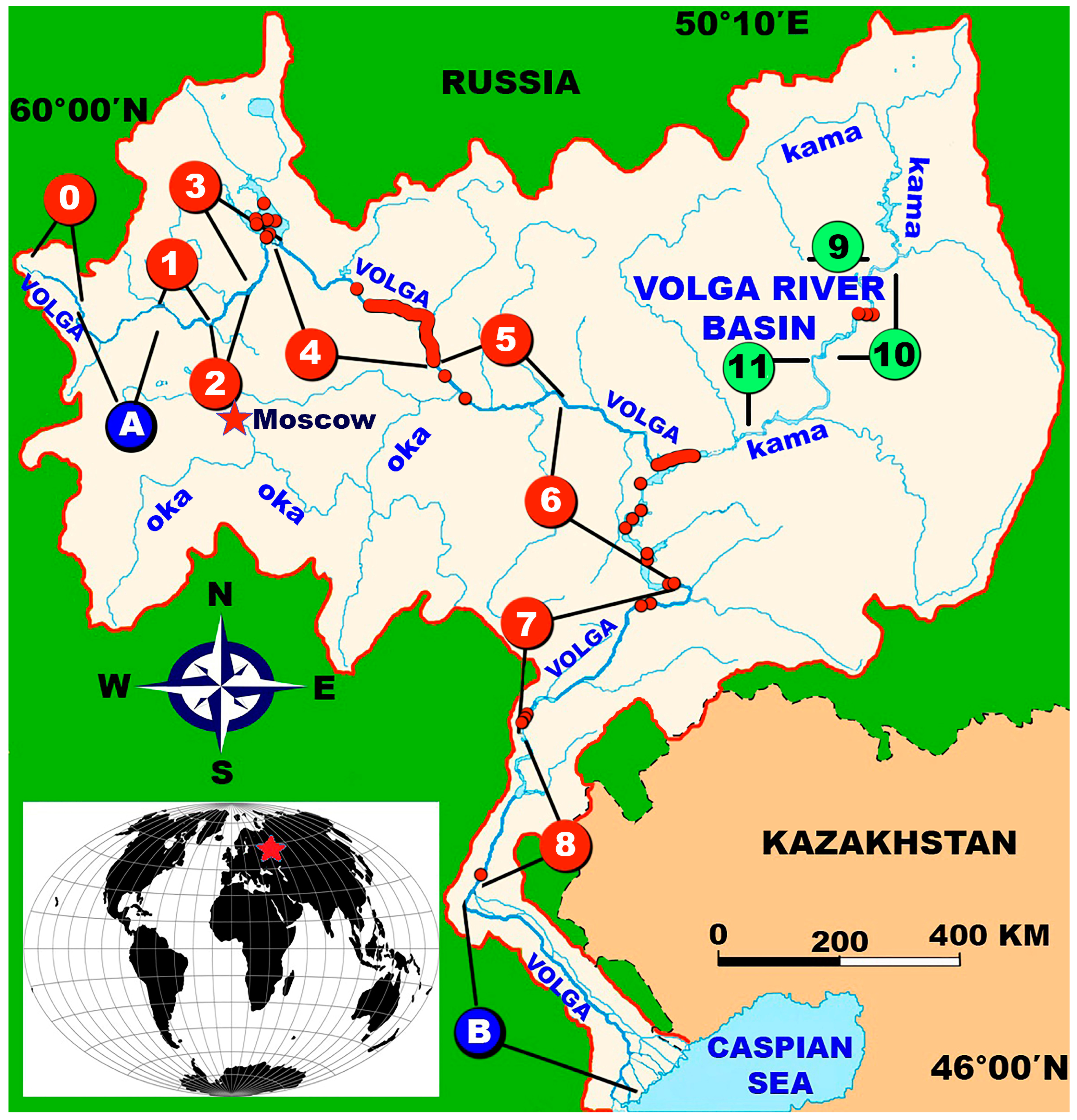
Figure 1.
Distribution of the Pallas’s Gull (Ichthyaetus ichthyaetus) in summer and autumn 2020–2022 in the fairway of the Volga–Kama reservoirs, the location of reservoirs and unregulated sections of the Volga. The red star in the inset shows the location of the Volga basin. Red circles with numbers indicate the Volga reservoirs: 0—Upper Volga; 1—Ivankovo; 2—Uglich; 3—Rybinsk; 4—Gorky; 5—Cheboksary; 6—Kuibyshev; 7—Saratov; 8—Volgograd. Green circles indicate the Kama reservoirs: 9—Kama; 10—Votkinsk; 11—Nizhnekamsk. Blue circles indicate unregulated sections of the Upper (A) and Lower (B) Volga. The small black-and-red circles and red thick lines are the sites of sightings of the Pallas’s Gull in the reservoirs.

Figure 2.
The Pallas’s Gulls (Ichthyaetus ichthyaetus) of different ages: (a)—adult in winter plumage eating Bream (Abramis brama). 17 September 2022, Kuibyshev reservoir; (b)—juvenile individual molting into first-winter plumage. 17 September 2022, Kuibyshev reservoir; (c)—individual in plumage of the second winter. 23 September 2020, Gorky reservoir; (d)—individual in plumage of the third winter. 15 September 2020, Saratov reservoir; (e)—individual in plumage of the third winter. 4 October 2020, Rybinsk reservoir; (f)—adult in summer plumage molting into winter plumage. 17 September 2022, Kuibyshev reservoir. Images: S. V. Golubev.


Table 1.
The main morphometric characteristics of the studied reservoirs.
| № | Name of Reservoirs | Reservoir Area (km2) | Length (km) | Maximum Width (km) | References |
|---|---|---|---|---|---|
| Volga reservoirs | |||||
| 1 | Ivankovo | 327 | 120 | 8 | [27] |
| 2 | Uglich | 249 | 143 | 5 | [27] |
| 3 | Rybinsk | 4550 | 250 | 56 | [27] |
| 4 | Gorky | 1591 | 430 | 15 | [27] |
| 5 | Cheboksary | 2214 | 341 | 16 | [28] |
| 6 | Kuybyshev | 6250 | 650 | 48 | [28] |
| 7 | Saratov | 1831 | 353 | 20 | [28] |
| 8 | Volgograd | 3117 | 540 | 17 | [28] |
| Kama reservoirs | |||||
| 9 | Kama | 1915 | 272 | 30 | [28] |
| 10 | Votkinsk | 1120 | 365 | 10 | [28] |
| 11 | Nizhnekamsk | 1370 | 430 | 20 | [28] |
Table 2.
Dates and length of transects in the fairway of the Volga–Kama reservoirs (2020–2022).
| № | Name of Reservoirs | 2020 | 2021 | 2022 | |||
|---|---|---|---|---|---|---|---|
| Dates | Length of Transect (km) | Dates | Length of Transect (km) | Dates | Length of Transect (km) | ||
| Volga reservoirs | |||||||
| 1 | Ivankovo | 3–4 August | 58.4 | 11–12 August | 60.5 | 31 July–1 August | 59.6 |
| 2 | Uglich | 4–6 August | 56.1 | 13 August | 56.7 | 1–2 August | 66.8 |
| 3 | Rybinsk | 6 August | 36.1 | 22–24 July | 183.5 | - | - |
| Rybinsk | - | - | 29 September | 22.0 | - | - | |
| Rybinsk | 1–4 October | 287.9 | 15–16 October | 109.9 | - | - | |
| 4 | Gorky | 22–26 September | 267.1 | 27–29 September | 206.4 | 27–29 September | 80.0 |
| 5 | Cheboksary | 19–21 September | 154.7 | 24–27 September | 196.4 | 22–26 September | 188.1 |
| 6 | Kuybyshev | 17–19 September | 216.0 | 21–24 September | 244.1 | 16–19 September, 21–22 September | 532.8 |
| 7 | Saratov | 13–16 September | 272.7 | 18–21 September | 198.4 | 20 September | 79.1 |
| 8 | Volgograd | 10–12 September | 209.3 | 16–18 September | 236.0 | - | - |
| Kama reservoirs | |||||||
| 9 | Kama | - | - | - | - | 09–10 September | 122.3 |
| 10 | Votkinsk | - | - | - | - | 11–13 September | 224.5 |
| 11 | Nizhnekamsk | - | - | - | - | 14–15 September | 208.1 |
Note: “-”—bird counts were not carried out.
Table 3.
Length, duration of surveys and expedition work, and the number of counted Pallas’s Gulls (Ichthyaetus ichthyaetus).
Table 3.
Length, duration of surveys and expedition work, and the number of counted Pallas’s Gulls (Ichthyaetus ichthyaetus).
| General Parameters of the Expedition/Years | 2020 | 2021 | 2022 | 2020–2022, ∑ |
|---|---|---|---|---|
| Length of count (km) | 1558.3 | 1513.9 | 1561.3 | 4633.5 |
| Duration of counts (hours) | 126.0 | 134.8 | 103.5 | 364.3 |
| Duration of work in the expedition (number of days with counts) | 25 | 25 | 24 | 74 |
| Total number of Pallas’s Gulls on the route (individuals) | 144 | 80 | 97 | 321 |
Table 4.
Status and abundance of Pallas’s Gulls (Ichthyaetus ichthyaetus) in the fairway of the Volga–Kama reservoirs, 2020–2022.
Table 4.
Status and abundance of Pallas’s Gulls (Ichthyaetus ichthyaetus) in the fairway of the Volga–Kama reservoirs, 2020–2022.
| Name of Reservoirs | 2020 | 2021 | 2022 | |||||||
|---|---|---|---|---|---|---|---|---|---|---|
| Ind/km2 | Ind/km Counting Strip | Status | Ind/km2 | Ind/km Counting Strip | Status | Ind/km2 | Ind/km Counting Strip | Status | ||
| № | Volga reservoirs | |||||||||
| 1 | Ivankovo | - | - | - | - | - | - | - | - | - |
| 2 | Uglich | - | - | - | - | - | - | - | - | - |
| 3 | Rybinsk | 0.060 | 0.012 | VR | 0.045 | 0.009 | VR | * | * | * |
| 4 | Gorky | 2.095 | 0.419 | C | 1.570 | 0.314 | C | 2.250 | 0.450 | C |
| 5 | Cheboksary | - | - | - | 0.125 | 0.025 | R | 0.050 | 0.010 | VR |
| 6 | Kuybyshev | 0.045 | 0.009 | VR | 0.100 | 0.020 | R | 0.475 | 0.093 | R |
| 7 | Saratov | 0.475 | 0.095 | R | - | - | - | - | - | - |
| 8 | Volgograd | 0.045 | 0.009 | VR | 0.060 | 0.012 | VR | * | * | * |
| Kama reservoirs | ||||||||||
| 9 | Kama | * | * | * | * | * | * | - | - | - |
| 10 | Votkinsk | * | * | * | * | * | * | - | - | - |
| 11 | Nizhnekamsk | * | * | * | * | * | * | 0.165 | 0.033 | R |
Note: C—common species; R—rare species; VR—very rare species; “-”—counts were carried out, but no birds were found; “*”—counts were not carried out.
Table 5.
Records of the Pallas’s Gulls (Ichthyaetus ichthyaetus) at the Rybinsk reservoir, 2020–2021.
Table 5.
Records of the Pallas’s Gulls (Ichthyaetus ichthyaetus) at the Rybinsk reservoir, 2020–2021.
| № | Dates | Age | Number of Individuals (n) | GPS Coordinates | |
|---|---|---|---|---|---|
| 1 | 1 October 2020 | adult | 1 | 58.43722° N | 38.28876° E |
| 2 | 1 October 2020 | >1 year | 1 | 58.35537° N | 38.05685° E |
| 3 | 2 October 2020 | adult | 1 | 58.67252° N | 38.28139° E |
| 4 | 4 October 2020 | >2 years | 1 | 58.37894° N | 38.64936° E |
| 5 | 23 July 2021 | adult | 1 | 58.42702° N | 38.47723° E |
| 6 | 16 October 2021 | adult | 1 | 58.21188° N | 38.45834° E |
| 7 | 16 October 2021 | adult | 1 | 58.21833° N | 38.45911° E |
Table 6.
The size of groups of the Pallas’s Gull (Ichthyaetus ichthyaetus) on the Volga–Kama reservoirs in the summer-autumn period, 2020–2022.
Table 6.
The size of groups of the Pallas’s Gull (Ichthyaetus ichthyaetus) on the Volga–Kama reservoirs in the summer-autumn period, 2020–2022.
| Name of Reservoirs | min | max | m | SD | Median | n | |
|---|---|---|---|---|---|---|---|
| № | Volga reservoirs | ||||||
| 1 | Ivankovo | - | - | - | - | - | - |
| 2 | Uglich | - | - | - | - | - | - |
| 3 | Rybinsk | 1 | 1 | 1 | 0 | 1 | 5 |
| 4 | Gorky | 1 | 17 | 3.4 | 3.7 | 2 | 63 |
| 5 | Cheboksary | 1 | 3 | 1.7 | 0.9 | 1.5 | 4 |
| 6 | Kuybyshev | 1 | 12 | 2.3 | 2.7 | 1 | 24 |
| 7 | Saratov | 1 | 13 | 5.4 | 4.5 | 4 | 5 |
| 8 | Volgograd | 1 | 1 | 1 | 0 | 1 | 5 |
| Kama reservoirs | |||||||
| 9 | Kama | - | - | - | - | - | - |
| 10 | Votkinsk | - | - | - | - | - | - |
| 11 | Nizhnekamsk | 1 | 5 | 2.3 | 2.3 | 1 | 3 |
Disclaimer/Publisher’s Note: The statements, opinions and data contained in all publications are solely those of the individual author(s) and contributor(s) and not of MDPI and/or the editor(s). MDPI and/or the editor(s) disclaim responsibility for any injury to people or property resulting from any ideas, methods, instructions or products referred to in the content. |
© 2023 by the author. Licensee MDPI, Basel, Switzerland. This article is an open access article distributed under the terms and conditions of the Creative Commons Attribution (CC BY) license (https://creativecommons.org/licenses/by/4.0/).
Share and Cite
MDPI and ACS Style
Golubev, S. Status of the Pallas’s Gull Ichthyaetus ichthyaetus during Summer/Autumn in the Fairway Volga–Kama Reservoirs (East European Plain) in Russia. Birds 2023, 4, 46-60. https://doi.org/10.3390/birds4010004
AMA Style
Golubev S. Status of the Pallas’s Gull Ichthyaetus ichthyaetus during Summer/Autumn in the Fairway Volga–Kama Reservoirs (East European Plain) in Russia. Birds. 2023; 4(1):46-60. https://doi.org/10.3390/birds4010004
Chicago/Turabian StyleGolubev, Sergey. 2023. "Status of the Pallas’s Gull Ichthyaetus ichthyaetus during Summer/Autumn in the Fairway Volga–Kama Reservoirs (East European Plain) in Russia" Birds 4, no. 1: 46-60. https://doi.org/10.3390/birds4010004