
Spatiotemporal Distribution of Photographic Records of Brazilian Birds Available in the WikiAves Citizen Science Database

Departamento de Biociências, Universidade Federal Rural do Semi-Árido, Campus de Mossoró, Mossoró 59625-900, RN, Brazil
Birds 2023, 4(1), 28-45; https://doi.org/10.3390/birds4010003
Submission received: 14 November 2022
/
Revised: 31 December 2022
/
Accepted: 18 January 2023
/
Published: 22 January 2023
(This article belongs to the Special Issue Birds and People)
Abstract
:Simple Summary
Citizen science refers to the participation of citizens in scientific research, and such participation has been increasing the knowledge about aspects of birds around the world. Citizen science projects receive the contribution of dozens, hundreds or thousands of citizens that gather records to be compiled and evaluated by scientists. This approach leads to the obtention of large amounts of data over large spatiotemporal scales. This is true for Brazil, especially through the WikiAves database, which currently harbors more than four million digital photographic records of birds. Due to the importance of this database for the knowledge of the national avifauna, this study aims to evaluate the spatiotemporal distribution of its photographic records. Geopolitical regions and states with high and low record productions were identified. Record production varies along the year, and this seasonality is specific to each biome. The discussion dealt with factors that might contribute to differences in record production. These explanatory factors are related to birds, humans and the environment. This article discusses how record availability might influence ornithological research and encourage scientists to make intense use of WikiAves records to study Brazilian birds.
Abstract
About four million photographic records of Brazilian birds are deposited in the WikiAves database. The objective of this study was to examine the spatiotemporal distribution of photographic records available in this database. Searches were performed in the database in 2022. Record numbers produced by citizens were obtained by selecting states and municipalities in different periods. The annual record production in Brazil has increased substantially since 2009, reaching about 400,000 records per year in 2020–2021. Most records were obtained in the Sudeste and Sul geopolitical regions. Seasonal variations in record production in the Cerrado and the Atlantic Forest are comparable, with more records obtained in July–October. In Amazonia, a more substantial decrease in record production occurred between November and April. The monthly record production was more uniform in the Caatinga. When municipalities were compared, similar seasonal variation in record production was observed for four ecosystems (Amazonia, Atlantic Forest, Cerrado and Pampa). However, substantial differences were observed for municipalities in the Pantanal and the Caatinga. The results indicate that high human density, high individual income and the breeding season of birds are potential factors leading to high record production. On the other hand, heavy rainfall, flooding, remoteness and environmental harshness are pointed out as factors potentially leading to relatively fewer records. Further, this article discusses the implications of record availability for ornithological studies that use photographic records deposited in the WikiAves database.
1. Introduction
Citizen science refers to the participation of citizens in scientific research, and such participation has been successfully increasing the knowledge about several aspects of the biodiversity found around the world [1,2,3,4,5]. In relation to birds, records produced by citizen scientists have been allowing the study of species by scientists in large-scale projects for decades [6,7,8,9]. For example, a long-term citizen science project has been monitoring bird populations in Finland since the 1950s [10]. Moreover, the British Trust for Ornithology coordinates thousands of volunteers to gather data to produce long-term datasets that are used, for example, to examine population trends and study bird migration [11]. Among other outstanding results are those produced at the Cornell Lab of Ornithology, showing seasonal patterns of relative abundance of migratory species [12,13,14].
Citizen science regarding birds is strongly tied to birdwatching, a traditional activity in regions such as North America and Europe that has increased substantially in the last two decades in Brazil [15]. There, birdwatching has been increasing since 2005 through the creation of nationwide initiatives, the promotion of bird fairs, the emergence of ornithological clubs, the conduction of citizen science projects and the creation of websites oriented to amateur ornithologists [15]. Among citizen science projects, WikiAves has organized a database since 2009. It currently harbors more than four million records of more than 1900 species through the contribution of about 43,500 citizen scientists [16]. This database can substantially improve knowledge of Brazilian avifauna [15,17].
Currently, the WikiAves database produces the largest amount of records regarding Brazilian birds, and its content has been used in a range of scientific studies by researchers. For example, continuously updated distribution maps based on photographs and sound recordings provide the documentary evidence expected by the Brazilian Committee of Ornithological Records [18,19,20]. These maps, checklists of localities, and single records have been used in numerous studies regarding geographic distribution [15]. For example, photographic and sound records of this database have been used in the production of checklists of regional avifaunas, as recently occurred for both the Rio Grande do Norte and Mato Grosso do Sul states [21,22] and the Pantanal wetland [23]. Further, WikiAves received digital records obtained in the Caatinga during recent inventories located in Bahia, Ceará and Pernambuco states [24], highlighting that professional ornithologists also have a role in increasing the database.
WikiAves records also can contribute to the knowledge regarding bird migration by complementing the information provided by museum vouchers, fieldwork and the literature. For example, Lees and Martin [25] examined the spatiotemporal distribution of the Rufous-thighed Kite Harpagus diodon (Temminck, 1823), a species commonly considered a resident. Through the use of WikiAves records, they pointed out that its populations are fully migratory, wintering in Equatorial forests of the Amazonian basin. Moreover, evidence of longitudinal migration by the “sedentary” Ash-throated Casiornis Casiornis fuscus (Sclater and Salvin, 1873) was obtained with the contribution of WikiAves data [26]. Further, Schubert et al. [27] used a range of migratory and resident species as models and reinforced that records available in WikiAves and other databases are adequate for migration studies in Brazil. Similarly, DeGroote et al. [28] revealed the cryptic migration of the Common Potoo Nyctibius griseus (Gmelin, 1789) in Brazil. The breeding and wintering areas of the Rufous-tailed Attila Attila phoenicurus (Pelzeln, 1868) in the Atlantic Forest and Amazonia were confirmed, mainly based on WikiAves records [29].
WikiAves photographic records also provide an opportunity for ornithologists to study other aspects of bird biology by representing, totally or partially, the records used in the research. For example, studies of agonistic interactions among birds or with other animals include mobbing behavior [30], predation/diet [31,32,33] and kleptoparasitism [34]. Moreover, several species had their breeding aspects examined, including the Pygmy Nightjar Nyctipolus hirundinaceus (Spix, 1825) in the Caatinga [35], the Helmeted Manakin Antilophia galeata (Lichtenstein, 1823) in the Atlantic Forest and the Cerrado [36], and a range of aquatic species in the Pantanal and the Cerrado [37,38,39]. Even copulatory behavior involving nuptial gifts among cuckoos could be studied with the use of photographs available in the WikiAves database [40].
Despite having contributed to numerous studies regarding bird distribution and biology [15], information available on the WikiAves website was scarcely examined in relation to citizen scientists that contribute to this database. For example, de Camargo Barbosa et al. [15] evaluated the geographic distribution of citizens that use the WikiAves website, showing high concentrations in southeastern and southern Brazil, especially in urban centers of São Paulo state. There are no studies that assessed the distribution of records considering the whole Brazilian avifauna and territory, nor studies that investigated seasonal variations in record production by citizens in different regions.
This study aimed to examine aspects of the spatiotemporal distribution of photographic records available in the WikiAves database. Firstly, the variation in the annual record production in Brazil since 2009, when this database was created, was examined. Then, the total production of records in different geopolitical regions, states, and the Federal District was examined to identify regions with more and fewer records. Moreover, the seasonal variation in record production in states and municipalities located exclusively within a given Brazilian ecosystem was investigated. It was supposed that ecological and social factors would lead to variations in record obtention and that it would be influenced by the ecosystem. Results were discussed in terms of factors that might influence spatiotemporal variation in record production by citizen scientists. Further, I discussed the implications of this variation for scientific studies that use photographic records of Brazilian birds available in the WikiAves database.
2. Materials and Methods
2.1. Study Area—Brazilian Ecosystems
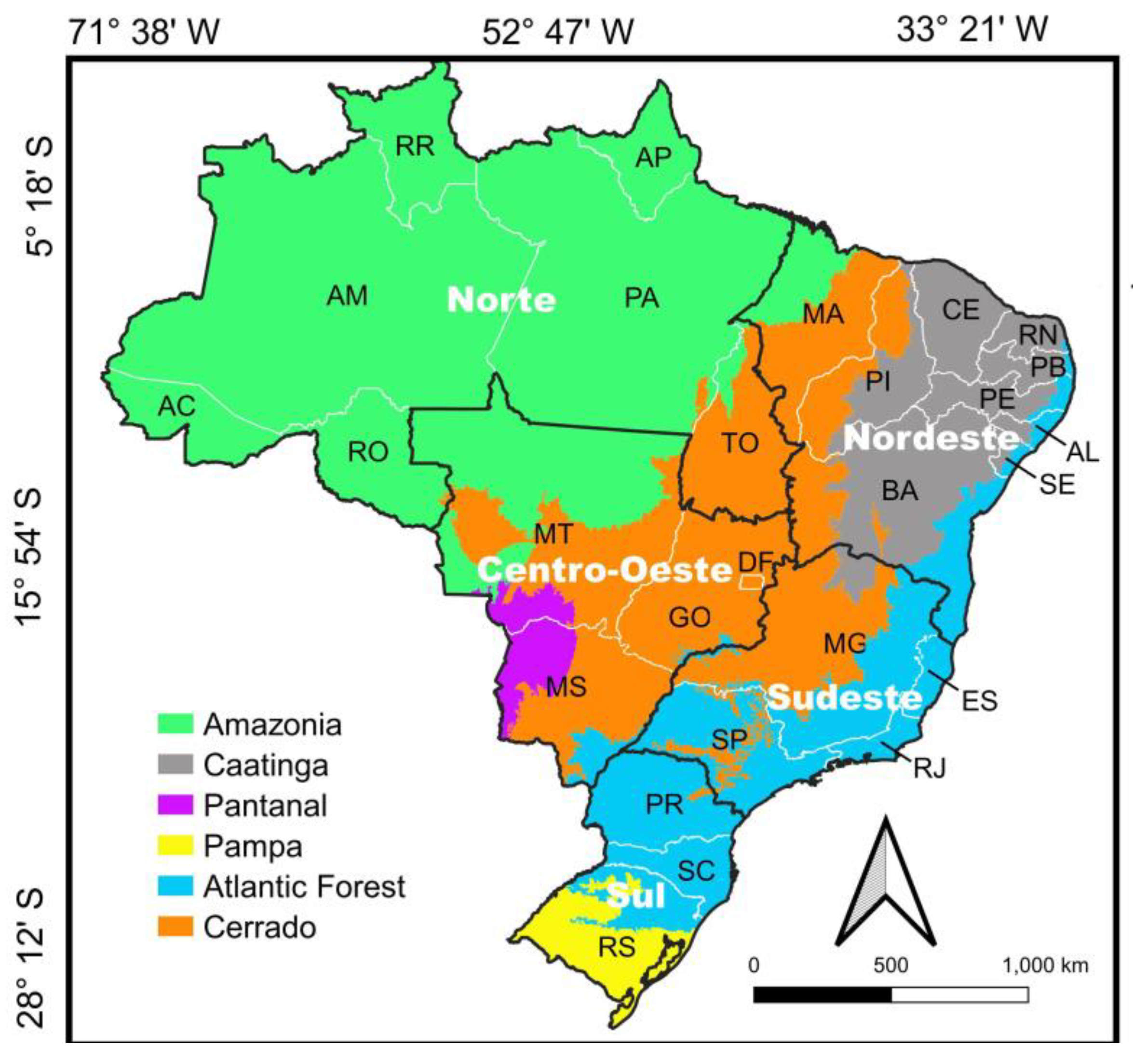
Brazil has six major ecosystems/ecoregions [41,42] (Figure 1). Most of its population, and more urbanized regions, occur mainly throughout the Atlantic Forest, comprising the Sudeste, Sul and Nordeste geopolitical regions [15]. The Cerrado is the savanna province that dominates central Brazil, where it covers about 1.8 million km2 [43,44]. Typically, matrix types of landscapes are open woodland savannas, grasslands and semideciduous forests [45]. Climate is tropical and marked by a dry winter and a rainy summer. Two well-defined seasons occur annually: the dry season occurs from May to September, and the rainy season occurs from October to April. The annual rainfall ranges between 1200 and 2000 mm. Temperatures usually vary between 10 °C in June/July and 40 °C in January/February [46].
The Caatinga is a dry forest region that covers about 800,000 km2, mostly in northeastern Brazil [47,48]. Its landscapes are covered by xeric vegetation, which includes several types of forests and shorter vegetation [49]. Climate in the Caatinga is tropical semiarid and characterized by high temperatures and irregular rainfall. Mean daily temperatures range between 26 °C and 28 °C and might reach 42 °C; the mean annual rainfall is 750 mm [49].
The Amazon covers about 50% of the Brazilian territory, occurring mainly in its northern region (Figure 1). Its landscapes are dominated by tropical forests and a wide range of humid areas that harbor extraordinary biodiversity [50,51]. Amazonia has a tropical climate, and the mean annual precipitation usually ranges between 2400 and 2800 mm; the Amazon region is subjected to a well-defined seasonal rainfall regime, and months with lower precipitation occur from May to September; it is one of the warmest regions in Brazil, with an average daily high temperature of 32 °C, often over 40 °C [50,51,52].
The Brazilian Pantanal is a wetland that lies in the Rio Paraguay hydrographic basin, where it covers about 140,000 km2 [53]. It occurs in portions of Mato Grosso and Mato Grosso do Sul states, and its terrain is marked by both low altitude and declivity [50]. The alteration between dry and flood periods is also remarkable, and there is a seasonal pattern of precipitation [54,55]. The dry season occurs from May to September, while the rainy season occurs between October and April, with a peak of rainfall in January and February [56,57]. Typically, the climate is predominantly hot and humid, with an average annual rainfall of 1500 mm, with maximum and minimum average temperatures of 32 ℃ and 20 ℃, respectively [23]. Major vegetation physiognomies are semideciduous and savanna forests, open savannas and grasslands. Typical water bodies are rivers, temporary river channels, ponds, lagoons and marshes [50,54].
The Atlantic Forest originally covered about 1.3 million km2, mainly along the Brazilian coast, but also Mato Grosso do Sul state, Argentina and Paraguay [58]. Landscapes are mostly covered by coastal forests and semideciduous forests [42,43]. Typically, the climate is tropical, being cooler in southern regions and in high-elevation mountains. Typically, in Rio de Janeiro state, annual precipitation ranges between 1200 and 1300 mm, with heavier rainfall between December and February; the annual mean temperature is about 18–24 °C, usually having maximum values between 10 °C and 40 °C [59].
The Brazilian Pampa lies in Rio Grande do Sul state, where it originally covered 63% of the landscapes. Grasslands are the landscape matrix; they are phytogeographically distinct from those found in the Cerrado, being similar to grasslands occurring in Uruguay [60]. The Pampa’s climate is subtropical, without a dry season and with hot or temperate summers. Mean annual temperatures range between 11 °C and 20 °C, and the mean annual precipitation ranges between 1000 mm and 2200 mm [59].
2.2. Data Obtention and Analysis
Records included in this study were obtained through searches for photographs of birds provided by WikiAves, a citizen science project coordinated by Reinaldo Guedes [16]. This project produces an interactive website dedicated to Brazilian birdwatchers and aims to support and promote birdwatching and citizen science. The website provides free advanced tools for the publication of photos, sounds, and other information regarding birds and their records. For example, it provides information on main characteristics of orders, families and species (https://www.wikiaves.com.br/wiki/aves; accessed on 26 December 2022), distribution maps of species (https://www.wikiaves.com.br/especies_buscaocorrencia.php; accessed on 26 December 2022), and a database that currently harbors 4,372,808 records (photographic records: 94%; sound records: 6%). This is the major citizen science database regarding Brazilian birds and currently receives the contribution of about 43,500 observers, most of them being citizen scientists/birdwatchers with a few professional ornithologists). They already recorded 1957 species, a richness comparable to that found in Brazil by professional ornithologists (1971 species) [20]. Although the database receives the contribution of foreign birdwatchers, most records have been obtained by Brazilians.
This study considered only photographic records because (1) they predominate the database, (2) their search differs from that of sound records, and (3) they are useful for a wider range of studies on birds when compared with sound records. All searches for photographs occurred in mid-May 2022 and were performed by selecting “Registros” (Records) and then “Busca Avançada” (Advanced search). (https://www.wikiaves.com.br/buscaavancada.php#). This section of the website gives opportunity to search for species, families and aspects of their biology (e.g., nest, egg, young, habitat, incubation, feeding); it also provides filters to search for records based on their location and date of obtention. This procedure leads to the obtention of only photographic records, not involving sound records (pers. observ.).
Then, a range of states and municipalities were individually selected in the fields “Estado” (state) or “Município” (municipality), respectively, to obtain record numbers gathered in specific periods (e.g., a particular month or year). The option “Data de Registro” (Date of Record) was used to select the periods of record obtention, and then “Buscar” (search) was clicked to obtain the number of records produced by citizen scientists—“Registros Encontrados” (Records Found). In this paper, the obtained record number was considered synonymous with record production, record obtention, and citizen/birdwatching activity. This is because more/fewer activities by citizen scientists might lead to more/fewer records. In this study, searches were performed with four objectives.
Firstly, noo states or municipalities were selected to discover the record numbers obtained annually in Brazil since the creation of the WikiAves database (2009), and the first and the last day of a given year were written in the fields regarding “Data de Registro” (Date of Record). For example, “1 January 2017” and “31 December 2017” were written in the left and right fields, respectively, to obtain the number of records gathered by citizen scientists in 2017 in Brazil. The only exception occurred for 2022 as this search was performed before the year’s completion; thus, the last date was 11 May 2022, when this search was performed.
Secondly, a given name (e.g., Bahia) was written in the “Estado” (state) field and the “Buscar” (search) option was clicked to discover the record numbers obtained in Brazilian states and at the Federal District. The resulting numbers involve all years of record production by citizens (January 2009 to May 2022). These individual searches were performed on 12 May 2022. The states and the Federal District were grouped into the five Brazilian geopolitical regions (Figure 1). Thus, record production in each geopolitical region refers to the sum of records produced within its states, including the Federal District for the Centro–Oeste region.
Thirdly, a single state was selected for seasonal variation to examine them in the record production of Brazilian ecosystems. These states had two characteristics: 1) a relatively high record production within a given geopolitical region (based on searches mentioned in the previous paragraph), and 2) each one had portions of a single ecosystem within its limits. As a result, the selected states (and corresponding ecosystems) were Goiás (Cerrado), Amazonas (Amazonia), Ceará (Caatinga) and Rio de Janeiro (Atlantic Forest). With this, it was possible to know the record production within a portion of a given Brazilian ecosystem, as there is no option for selecting ecosystems in the WikiAves search system. This was not possible for the Pampa and the Pantanal, as they do not encompass a whole state within their limits. For each of the four selected states, 72 searches were performed to know the monthly record production during the last six complete years (2016–2021); these 72 searches refer to the 12 months of each of these six years. This period corresponds to about half of the database in existence and to the years with the highest record productions (see objective A above; Figure 2). Thus, for a given search, a state (e.g., Amazonas) was selected and then the initial and last dates of a given month were written in the “Data de Registro” fields (e.g., 1 January 2018 and 31 January 2018 for January 2018). These searches were performed between 12 and 20 May 2022. After having performed the 72 searches for each one of the four selected states, the record numbers produced in each month during the six years were summed (e.g., May 2016–2021). With this, the seasonal variation in record production for the selected states could be examined.
Fourthly, thirty municipalities were selected (five of each Brazilian ecosystem) to examine spatiotemporal variation in record production within a given ecosystem. These municipalities had the following characteristics: (1) they had the highest record production within a given ecosystem or state; (2) preferably, they were in the states selected in the previous searches (Amazonas for Amazonia, Goiás for Cerrado and Rio de Janeiro for the Atlantic Forest). As Ceará state does not have many municipalities with high record production, the municipalities selected for the Caatinga had to be relatively widespread within its limits, thus involving more than one state. For the Pantanal and the Pampa, the five municipalities with relatively high record production were selected. None of these 30 municipalities were along the coast to avoid the inclusion of records obtained on marine beaches. The records obtained in Mato Grosso and Mato Grosso do Sul states represent the “Pantanal region”, as their selected municipalities encompass portions of both the wetland and the adjacent Cerrado landscapes, and this distinction is not available in the database. For each of the 30 selected municipalities, 72 searches were performed to know the monthly record production during the last six years, as described for the states above. These searches were performed between 18 and 26 May 2022.
Although ornithological studies based on citizen science data have usually discarded replicates (repetitions) of photographs taken in a given locality during a certain day [33,38,39], this procedure was not followed because this article: (1) deals with a huge amount of photographic records, (2) is not investigating aspects of the abundance or natural history of birds, (3) is investigating birdwatching activity. Moreover, replicates of photographs also represent actions by citizen scientists; these replicates usually do not represent more than 2–3% of the photographs that result from searches in the WikiAves database (pers. observ.).
3. Results
3.1. Annual Record Production in Brazil
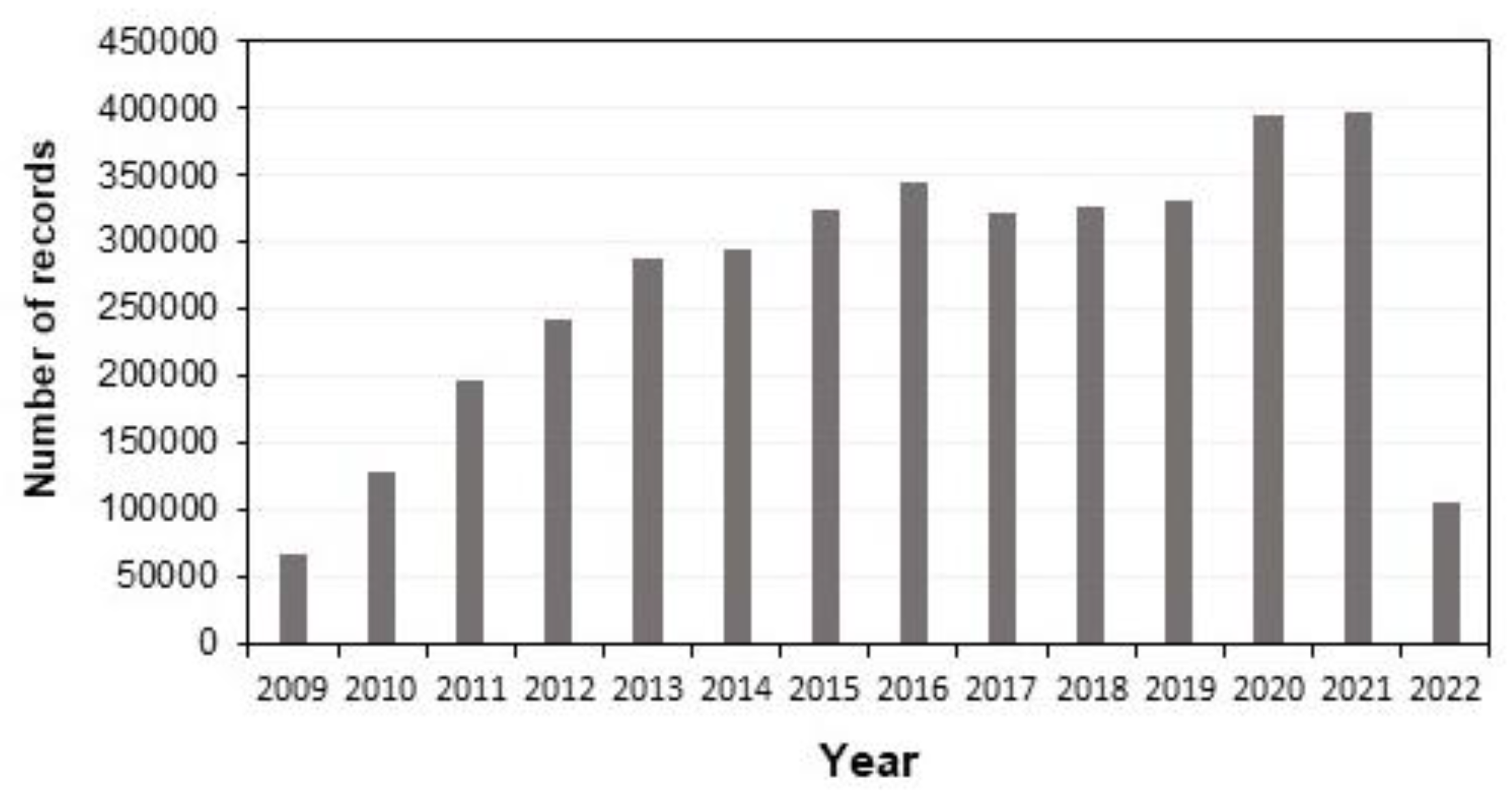
Citizen scientists have deposited approximately 3.75 million photographic records in the WikiAves database up to mid-May 2022. The annual record production has tended to increase since this database was created (Figure 2). It increased in a similar manner until 2016 but decreased slightly in the next three years. On the other hand, record production increased substantially in 2020 and 2021, when nearly 400,000 records were obtained in both years. The 2022 production had not been completed during the search period of this study (Figure 2).
3.2. Records in Geopolitical Regions
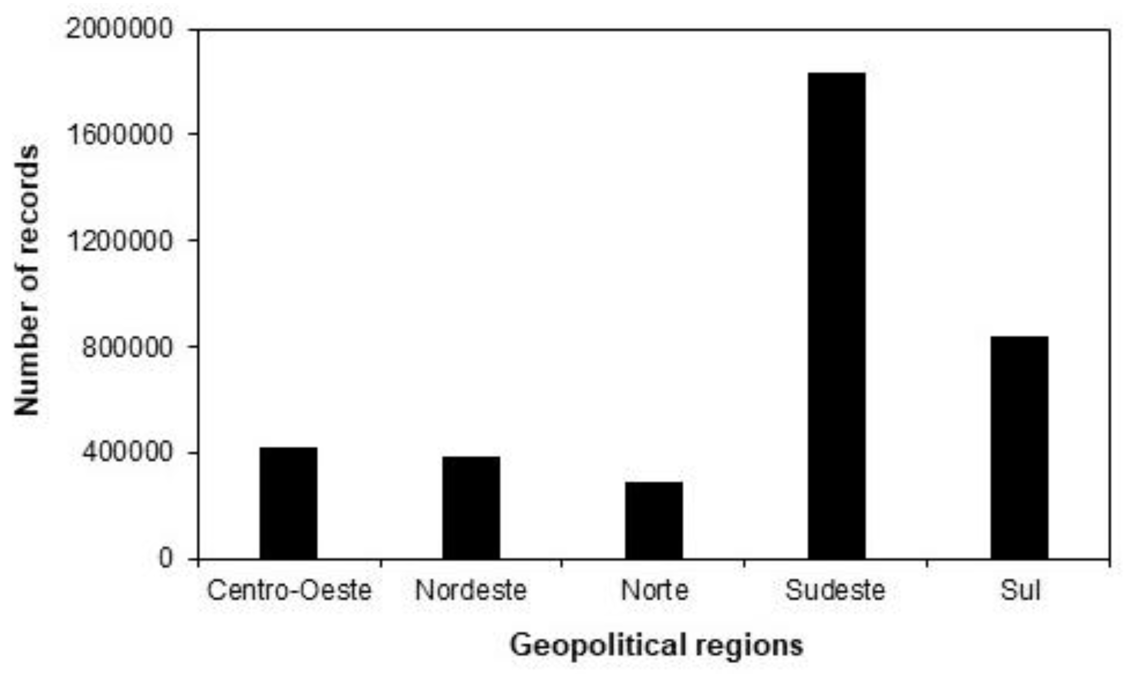
The total record production obtained by citizen scientists until 2022 was substantially higher in Sudeste (49% of the total for Brazil) than in other regions (Figure 3). Sul region had an intermediate record production (22%). The Centro–Oeste and Nordeste regions had comparable record productions (11% and 10%, respectively), while fewer records were obtained in the Norte region—about 300,000 photographs (8%) (Figure 3).
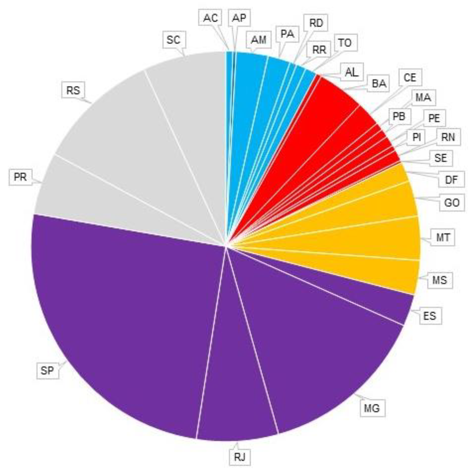
In the Sudeste region, most records were obtained in the São Paulo and Minas Gerais states (Figure 4). In the Sul region, most records were obtained in the Rio Grande do Sul state. In the Norte region, the Amazonas and Para states had the highest record numbers. In the Nordeste region, Bahia and Ceará had the most records. Further, the Mato Grosso state had the highest record production in the Centro–Oeste region, while Mato Grosso do Sul and Goiás had comparable record numbers. (Figure 4).
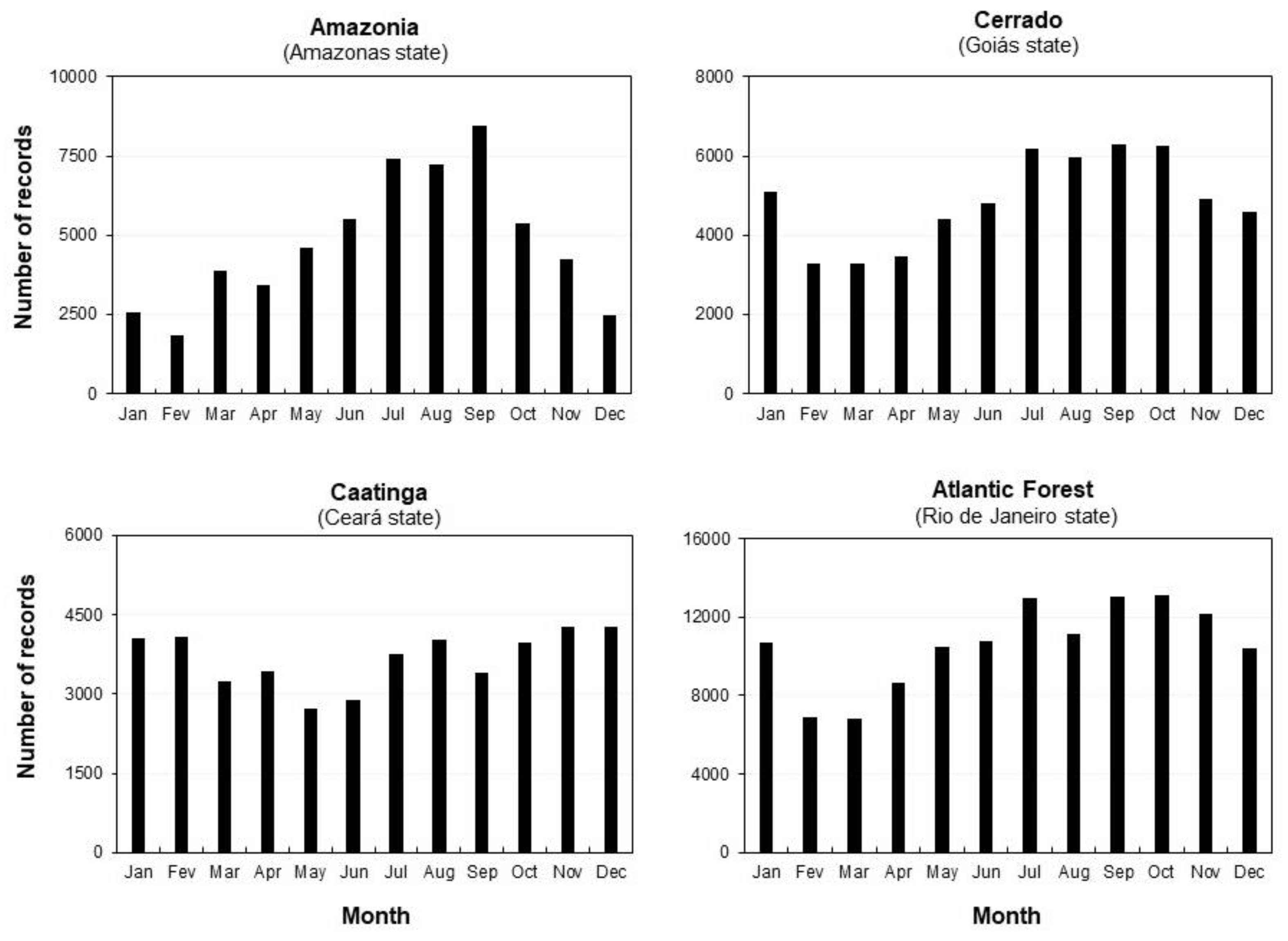
3.3. Seasonal Variation in the Monthly Record Production within Ecosystems
From 2016 to 2021, photographic records were gathered year-round by citizens in the states selected to represent portions of Brazilian ecosystems (Figure 5). When summed for this six-year period, the highest monthly record productions in central Cerrado (Goiás state) occurred between July and October. On the other hand, a period that comprises six months (November to April, except January) was marked by fewer records. May and June had intermediate record productions. A comparable seasonal variation in record production was observed in the southeastern Atlantic Forest (Rio de Janeiro state). In both ecosystems, the highest monthly record productions corresponded to nearly double those obtained in months marked by relatively low record production (e.g., compare March with September) (Figure 5).
However, a more substantial seasonal variation in record production occurred in central Amazonia (Amazonas state). A three-month period (July to September) had a relatively high monthly record production. Then, a substantial decrease in record production was observed since October, with fewer records obtained in February. Further, increasing monthly record production from March to June was observed when intermediate values occurred. Months with the highest record productions (July to September) had about three times more records than December to February (Figure 5). In contrast, differences in the seasonal variation in record production in northern Caatinga (Ceará state) were less remarkable than in other biomes. Relatively high monthly record productions occurred from November to February and were about 1.5 times higher than those obtained in May to June when fewer records occurred (Figure 5).
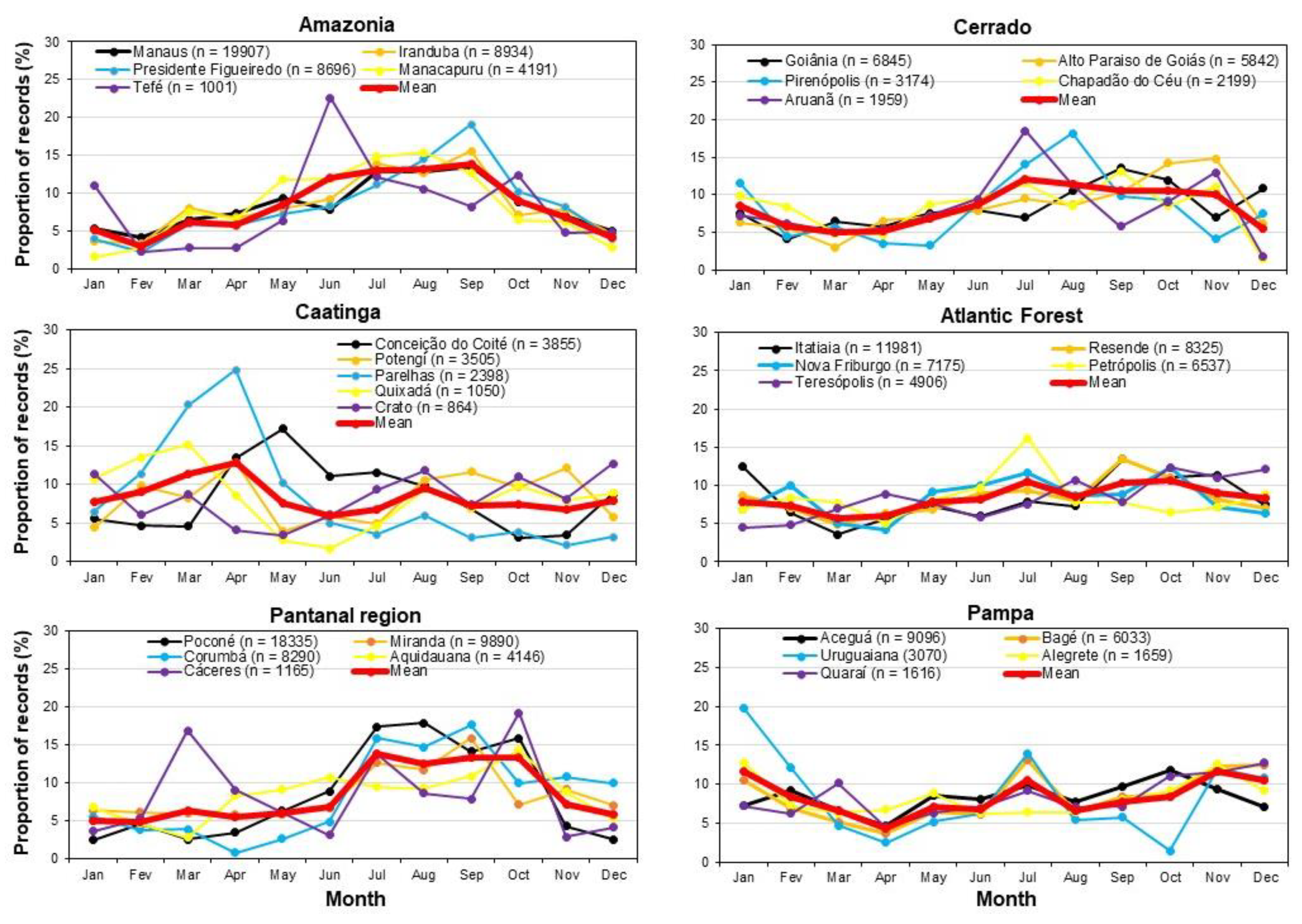
3.4. Seasonal Variation in the Monthly Record Production within Municipalities
For municipalities located in central Cerrado, when considering a six-year period (2016–2021), the mean record production was higher between July and November than in other months. The greatest differences between the monthly record productions of the five selected municipalities occurred from July to August and November to December (Figure 6). Aruanã was the municipality that showed the greatest differences in relation to the mean production. In the southeastern Atlantic Forest, seasonal variation in the mean record production was similar to that observed in the Cerrado municipalities; the main differences occurred due to relatively fewer records in August. The greatest differences between the monthly record productions of the five selected municipalities and the mean production occurred in July and October due to records obtained in Petrópolis (Figure 6).
In central Amazonia, the mean monthly record production was substantially higher between June and September than in other months (Figure 6). The monthly record production of the five localities was similar in most months, except in June and September, mainly to records obtained at Tefé. In the Caatinga, the mean monthly record production was higher from March to April and in August than in other months (Figure 6). Substantial differences between the monthly record productions of the five selected municipalities occurred throughout the year, mainly in Parelhas.
On the other hand, the monthly record production was similar in the five selected municipalities during most months in Pampa (Figure 6). The main differences occurred due to records obtained in Uruguaiana in January and October. In the Pantanal region, substantial variation in the mean monthly record production occurred throughout the year, with higher values between July and October than in other months. The main differences between the monthly record productions of the five selected municipalities occurred due to record obtention in Cáceres (mainly March) and Corumbá (April–May) (Figure 6).
4. Discussion
The amount of photographic records produced by citizen scientists and deposited in the WikiAves database until May 2022 led to the detection of 1957 bird species, which represent 99.3% of the national avifauna recorded by professional ornithologists [20]. This means that data produced by citizen scientists can contribute to the knowledge of the great majority of the bird species found in Brazil. The set of search options available in the WikiAves website allowed the examination of data through several spatial and temporal scales.
4.1. Factors Influencing the Spatiotemporal Record Production
The increasing annual record production observed for Brazil since 2009 might be strongly influenced by the number of citizen scientists that contribute to the WikiAves database. Their numbers have been increasing since its creation [15], and more records might reflect mainly more active contributors. Interestingly, record production kept increasing in 2020 and 2021 despite the COVID-19 pandemic. Citizens likely found a range of ways to keep birdwatching by connecting with nature or other green areas and maintaining the need for social isolation because of this pandemic. Contrary to this pattern shown by WikiAves records, a study based on questionnaires sent to birders worldwide reported that COVID-19 had changed their birding behavior—birdwatching activities increased significantly [61]. In part, this difference occurs because the WikiAves website does not provide refined information on the record location within municipalities. As quarantines were not uniform throughout Brazil, future studies interested in this topic could examine the influence of the pandemic by comparing record productions in municipalities or regions with distinct rigidity.
The Sudeste and Sul regions, where people’s income is relatively high [62], comprised more than 70% of the record production obtained in Brazil. The purchasing power of citizen scientists might contribute to this concentration of records, as photographic equipment used for record obtention is usually expensive. Other explanatory factors might be the widespread inclusion of birdwatching in the culture of people that live in these two geopolitical regions [15]. Moreover, they are marked by relatively large human populations [62], and more citizens might lead to more records. Other factors that might influence positively record production in some regions are citizen science projects, ecotourism, the cohesion of birdwatching groups, landscape leisure, and safety and facilities for birdwatchers, including those with relative access to target areas; moreover, incentives for the obtention of photographic records and their inclusion in databases might increase record production [15,63,64,65,66]. Further, characteristics of the regional avifauna, such as the presence of rare, endemic, threatened and/or beautiful species, as well as remarkable bird abundance and diversity, might attract more birdwatchers [64,65,66], with a consequent increase in record production (Figure 7).
By examining seasonal variation in record production in portions of different ecosystems, more explanatory factors become evident. The Goiás and Rio de Janeiro states had similar patterns of record production throughout the year. The relatively low record productions obtained from November to March might reflect mainly high precipitation during this period in these portions of the Cerrado and the Atlantic Forest. Heavier rainfall makes gathering records difficult, as more care is needed with the photographic equipment. Moreover, more rainfall represents less time with good weather, and sometimes rainfall might lead to inadequate terrain for walking or driving. The negative influence of heavy rainfalls on record production appears to be stronger for central Amazonia (Amazonas state), where values decreased substantially from November to March (mainly from December to February). In this region, heavy rainfall is combined with flooding [52,67], and thus both might contribute considerably to reducing birdwatching activities.
On the other hand, seasonal variation in record production was not so dramatic in northern Caatinga (Ceará state), and this pattern also might be influenced partially by precipitation. This region is marked by strong spatiotemporal variation in precipitation [49]. Thus, the combination of numerous municipalities within a single state might lead to unremarkable differences in precipitation over a year, considering the six-year period involved in this study. Rainfall might lead to the difficulties mentioned above, in addition to substantially increasing the foliage density, possibly making it difficult to record obtention as birds become more cryptic. As birds tend to move from particular areas after periods marked by the absence of rain (see review in Araújo and Silva [68]), low rainfall might lead to fewer records. Further studies are necessary to quantify and understand the role of precipitation on record production in the Caatinga and other ecosystems.
Increases in record production from July to September/October, as observed for the southeastern Atlantic Forest, central Cerrado and central Amazonia, might result from several factors. Among them is bird activity, which increases in this period due to the arrival of the breeding season for many species in most parts of Brazil [69]. With more frequent bird songs and movement due to breeding activities, birdwatchers might have more opportunities to photograph birds from July to October. Holidays, expeditions and other birdwatching activities also might contribute to increasing record production in this period marked by relatively low precipitation.
When municipalities with relatively high record production were examined, mean values showed seasonal patterns similar to those observed for the four ecosystems assessed. This is because higher values occurred from July to October in municipalities located in the Cerrado, the Atlantic Forest and the Amazon, while no clear pattern occurred in the Caatinga. Thus, there is considerable similarity in record production at local and regional spatial scales in these ecosystems. This might reflect the influence of comparable factors related to humans, birds and the environment at different spatial scales of these ecosystems.
On the other hand, record obtention in each municipality was considerably different from the mean production during some months in four ecosystems (Cerrado, Atlantic Forest, Amazon and Pampa), indicating that some variability occurs within a regional scale. For example, more records in July at Aruanã might reflect its attraction for birdwatchers as river beaches arise [50]. Such variation was more remarkable when comparing municipalities of the Caatinga, which showed substantial differences throughout the year. The high regional variability in rainfall in the Caatinga [49], with consequent influence on bird and birdwatcher abundance, might contribute to this variation among municipalities.
Municipalities of the Pantanal region also showed considerable variation in record production in some months. For example, the lowest record productions occurred from November to March at Poconé and mainly in May and April at Corumbá. This delayed decrease in record production at Corumbá likely reflects a negative influence of flooding on birdwatching in the Pantanal wetland. This is because water from the rainy season in the northern parts of the Pantanal region takes some weeks to arrive at the wetlands of Corumbá through Rio Paraguai [50,54,55]. On the other hand, higher values of record production from July to October in most municipalities of the Pantanal region might reflect relatively easier access to the wetland during dry periods. Moreover, the extraordinary abundance of birds and the breeding season of many species during the dry season [69,70,71] also might attract more citizen scientists, with a consequent increase in record production from July to October.
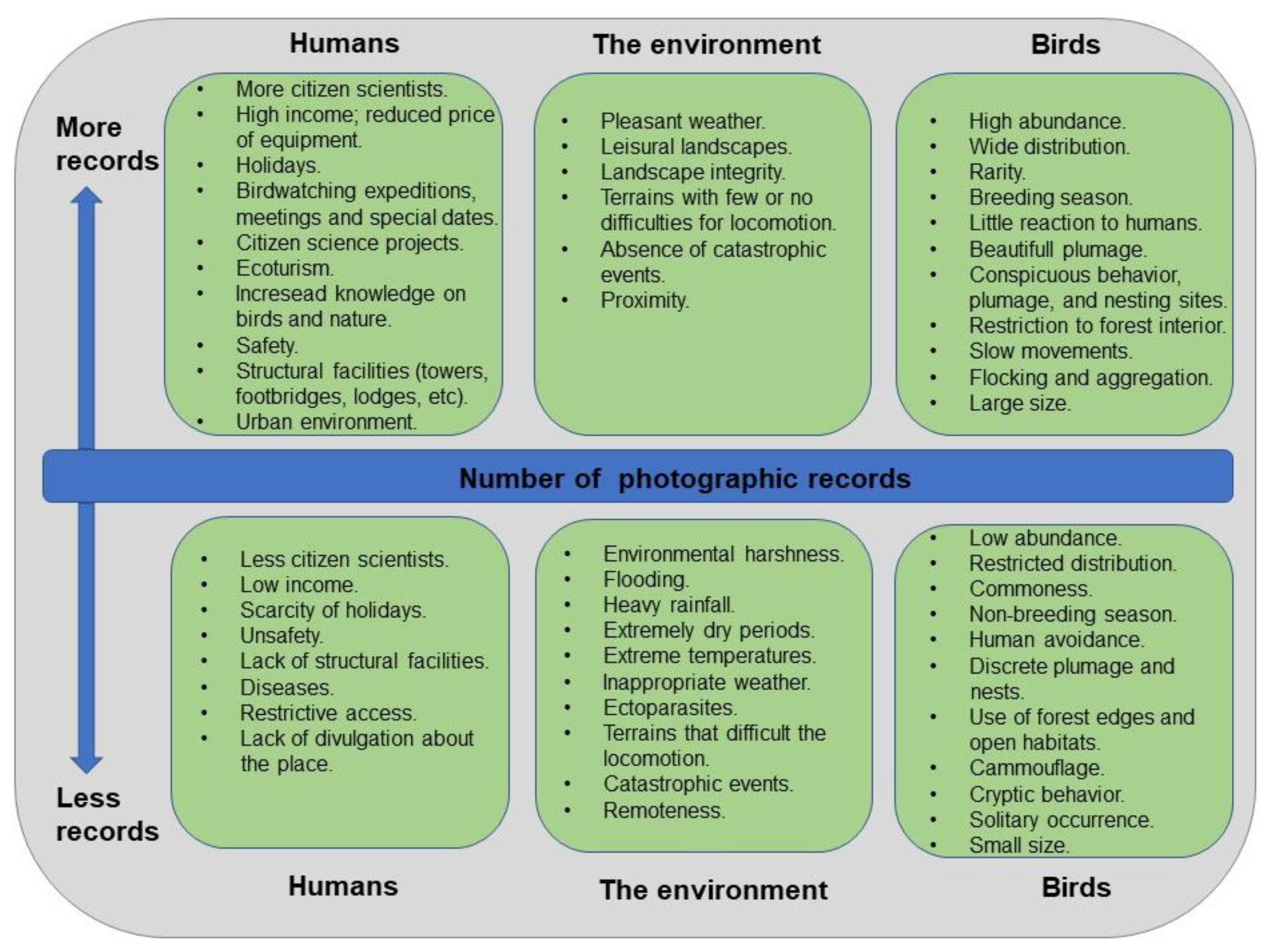
Therefore, the evaluation of the record numbers obtained by citizen scientists in different periods, states, municipalities and portions of major Brazilian ecosystems suggests that numerous factors might lead to variation in record production. An explanatory model shows factors that might lead to higher or lower record production in a given region/area during a certain period (Figure 7). These factors can be grouped into three categories that are related to humans, the environment and birds. Detailed studies are necessary to examine and quantify the influence of these and other factors on record production by citizen scientists in different situations.
4.2. Implications of Variation in Record Production for Scientific Studies
The current amount of photographic records of 1957 bird species available in the WikiAves databse implies a mean of ~1920 photographs per species. Around this mean are large sets of photographs, such as those of widely distributed and common birds [69]. For example, there are 14,739 records of the Toco Toucan (Statius Müller, 1776) and 16,665 records of the Guira Cuckoo Guira guira (Gmelin, 1788) in the database. On the other hand, there are small sets of records for uncommon species with restricted distribution in Brazil [69], such as those of the White-bellied Hummingbird Elliotomya chionogaster (Tschudi, 1846) (n = 42) and the Cinereous Tyrant Knipolegus striaticeps (d’Orbigny and Lafresnaye, 1837) (n = 43). Future studies could examine how species-specific variation in record production can be influenced by characteristics of species, such as their geographic distribution, abundance, size and conspicuousness. Similarly, studies could focus on the role of potential factors related to humans and the environment on record production by citizen scientists (Figure 7).
Record productions have been useful for ornithologists to study a range of aspects of the natural history of birds, such as breeding [35,36,37], behavior [30,34], diet [31,32,33] and migration [25,26,27,28,29]. It is probable that the WikiAves database already provides appropriate data sets for the study of dozens or, maybe, hundreds of species. Thus, valuable information is currently available to be used by professional ornithologists, especially if records are joined with those obtained in other databases, such as eBird Brasil, and those of global audiences, such as iNaturalist and Macaulay Library. Therefore, the WikiAves database is useful not only for the production of updated and reliable maps of the record distribution of species. The contribution of this database for ornithology goes beyond knowledge about the geographic distribution and reaches several aspects of bird biology (see references above). This might be especially true for abundant birds that are found in regions marked by high record production, such as the southeastern Atlantic Forest.
Small sets of photographs might contribute only to the study of the geographic distribution of species at the moment. This is because photographs that show, for example, the breeding activities of birds represented only a small part of the total set of photographs of a given species. For example, only 1–2% of the photographs available for the Orinoco Goose Neochen jubata (Spix, 1825) and the Sunbittern Eurypyga Helias (Pallas, 1781) in Brazil brought information about their breeding activities [38,72]. Thus, researchers should expect hundreds or a few thousands of photographic records to investigate breeding aspects of species through WikiAves records. It is important that researchers inform the total number of available records of the species being studied in addition to showing evidence of their activities, such as those related to breeding and foraging. This would help in learning the proportion of records that bring information on the natural history of birds, an important fact when deciding to study a given species.
Some studies could examine breeding and other aspects of species across large spatial scales and reveal that record numbers were not uniform along the area assessed [38,73,74]. This spatial variation in record numbers might represent a combination of species abundance and citizen activity. In these studies, some regions, such as northern Cerrado and western Caatinga, had no or few records. In part, this represents a low record production by citizen scientists in states with territories in these regions, as shown in this study. Thus, researchers should expect to obtain enough records in states marked by a combination of both high record production and bird abundance. By joining several states, substantial amounts of data can be obtained for investigations of species within a given ecosystem, as occurred for several studies. For example, the Atlantic Forest of southeastern Brazil can be intensively studied as huge amounts of records have been produced in the São Paulo, Rio de Janeiro and Minas Gerais states; the same occurs for central Cerrado.
Citizens scientists produce records throughout the year in the six Brazilian ecosystems. Thus, WikiAves records are appropriate for studying aspects of bird biology, such as migration, breeding season and seasonal variation in trophic habits. However, researchers should be cautious when studying regions such as the Amazon and the Pantanal. This is because record production is substantially reduced during months of heavy precipitation and flooding. Thus, few records during certain periods might represent reduced birdwatching, not necessarily few/no birds or the absence of certain activities, such as incubation. Checking the record production of the whole bird community within a certain region (as in Figure 5) is recommended when dealing with the study of seasonal variation, especially if records of the target species are not abundant.
This is especially true when studying seasonality in species occurrence within municipalities. For example, when searches were performed for the five municipalities located in the Caatinga, record production was nonexistent during several months of a given year. This monthly absence of records has not occurred for the municipalities of other ecosystems. However, record production was substantially lower during several particular months. This problem can be reduced or eliminated by combining several municipalities in the WikiAves search system or studying birds within extensive portions of ecosystems (e.g., northern Pantanal or central Amazonia).
4.3. Suggestions for the WikiAves Citizen Science Project
The possibility of obtaining information on digital records in the database through options such as “mapas de registros” (maps of records) and “busca avançada” (advanced search) provides excellent opportunities for researchers. Despite this, I made some suggestions below in an attempt to improve options for record compilations.
This article suggests that every record should be accompanied by information on the ecosystem (biome) where it was obtained, as currently occurs with the date and municipality. Although WikiAves maps show the distribution of records of a given species within the six Brazilian ecosystems, their compilation by scientists interested in particular ecosystems would become easier if each record were associated with this information. Thus, the creation of a filter “ecosystem/biome” in the search system would be welcome. If possible, programmers could add this information for each record already available in the database, as well as for future additions. This could be based on information provided for each municipality by IBGE (https://cidades.ibge.gov.br/; accessed on 27 December 2022).
Numerous records have been gathered in ecotonal zones throughout Brazil, as can be noted by viewing the distribution maps of widespread species. Thus, more refined information about the locality of record obtention would be important for scientists using data produced in these transitional regions. This is especially important for the Pantanal region because municipalities that contain portions of the wetland also encompass portions of the adjacent highlands. For example, by using the “Território e ambiente” (Territory and environment) option in IBGE for the Poconé municipality, the resulting information on the ecosystem is “Cerrado; Pantanal”. As municipalities associated with the Pantanal wetland (especially Corumbá) are huge, scientists studying its birds currently have to ask for information on the record location for citizen scientists through the comments section. This problem is further complicated by the fact that WikiAves maps do not show any record within the Pantanal wetland for any species, as cities of municipalities lie in the adjacent highlands and not in the wetland. Thus, it would be important that each record obtained in the Pantanal region is associated with more refined information on the location where it occurred. This could be achieved by providing the names of pousadas or farms, geographic coordinates and/or information about the ecosystem (e.g., Pantanal or Cerrado) for each record.
Further, this article suggests the creation of two filters related to temporal scales: “mês” (month) and “ano” (year). This would ease the obtention of records by researchers focusing on the seasonal variation in their occurrence, as performed for Figure 5 and Figure 6 in this study. For example, with this, the 72 searches performed for each ecosystem or municipality would be substantially reduced, especially if months and years can be combined (e.g., January 2015–2021 or June-August 2020).
4.4. Shortcomings
Record obtention in this study led to some minor shortcomings in the results. First, when gathering the annual productions for Brazil (Figure 2), searches also included records obtained overseas. However, I consider that the resulting records for Brazil are minimally influenced by these overseas records, as they were about 33,300 during the search period (shown by the option “Exterior” (overseas) in the state filter). Thus, they represent only 0.8% of thephotopgraphic records available in the database during the search period. Second, although the Rio de Janeiro and Ceará states contain beaches within their limits, I consider that the records obtained in the searches can represent the southeastern Atlantic Forest and northern Caatinga, respectively, as their coastal lines correspond to minimal portions of their territories. Due to less area, records obtained along marine beaches would not have a great influence on the number of records obtained in these two ecosystems (Figure 5). Moreover, as this study was based only on photographic records, different patterns of record distribution throughout Brazil might be obtained if considering exclusively sound records or using questionnaires. This is because distinct people would be involved in record gathering due to the costs of equipment and birding.
5. Conclusions
As WikiAves records have been obtained along the year and throughout the Brazilian territory, studies that use these data to investigate spatiotemporal variation in bird distribution and biology are promising. For example, with these records, it is possible to compare aspects of birds in distinct ecosystems, and over several years, a fact hardly (or never) achieved when considering research-based record obtention by scientists.
Record numbers obtained by citizens have been dramatically higher than those obtained by scientists through fieldwork. Highlighting this fact are recent studies on the breeding biology of aquatic and land birds [38,73,74]. For example, while citizen scientists produced 29 photographic records of mating events by cuckoos with a nuptial gift in Brazil, three articles mentioned the observation of this behavior by species of this bird family in the Neotropics since the 1940s [40].
Although record production is still not intense in some states or regions, the potential of WikiAves data for increasing the knowledge of the Brazilian avifauna is immense. Therefore, this study strongly suggests that ornithologists interested in studying Brazilian birds consider the databases produced by citizen science projects such as WikiAves. Other relevant database is that of eBird Brasil, that currently that harbours records of 1793 species through the contribution of about 11,000 citizen scientists [75]. Further, birdwatching is a nature-related activity whose initial involvement is strongly influenced by factors such as social influence, nature experience, bird-centered triggers, education and cognitive–emotional aspects (interest, curiosity) [76]. Thus, it would be important that Brazilian governmental and non-governmental organizations, birdwatching groups and citizen science projects consider these aspects to make WikiAves and other databases even more important for producing knowledge on birds.
Funding
This research received no external funding.
Institutional Review Board Statement
Not applicable.
Data Availability Statement
Not applicable.
Acknowledgments
I thank Universidade Federal Rural do Semi-Árido for logistic support. I am also grateful to all citizens that contribute to the production of the WikiAves database. Ivinna K. C. Vieira produced the map. Adriano P. Campos reviewed the English. Jukka Jokimäki, two reviewers and Luis Inoue improved this manuscript with numerous suggestions.
Conflicts of Interest
The author declares no conflict of interest.
References
- Bonney, R.; Cooper, C.B.; Dickinson, J.; Kelling, S.; Phillips, T.; Rosenberg, K.V.; Shirk, J. Citizen science: A developing tool for expanding science knowledge and scientific literacy. BioScience 2009, 59, 977–984. [Google Scholar] [CrossRef]
- Bela, G.; Peltola, T.; Young, J.C.; Balázs, B.; Arpin, I.; Pataki, G.; Hauck, J.; Kelemen, E.; Kopperoinen, L.; Van Herzele, A.; et al. Learning and the transformative potential of citizen science. Conserv. Biol. 2016, 30, 990–999. [Google Scholar] [CrossRef] [PubMed] [Green Version]
- Turnhout, E.; Lawrence, A.; Turnhout, S. Citizen science networks in natural history and the collective validation of biodiversity data. Conserv. Biol. 2016, 30, 532–539. [Google Scholar] [CrossRef]
- Bonney, R. Expanding the impact of citizen science. BioScience 2021, 71, 448–451. [Google Scholar] [CrossRef]
- Johnson, N.; Druckenmiller, M.L.; Danielsen, F.; Pulsifer, P.L. The use of digital platforms for community-based monitoring. BioScience 2021, 71, 452–466. [Google Scholar] [CrossRef]
- Sullivan, B.L.; Wood, C.L.; Iliff, M.J.; Bonney, R.E.; Fink, D.; Kelling, S. eBird: A citizen-based bird observation network in the biological sciences. Biol. Conserv. 2009, 142, 2282–2292. [Google Scholar] [CrossRef]
- Chandler, M.; See, L.; Copas, K.; Bonde, A.M.; López, B.C.; Danielsen, F.; Legind, J.K.; Masinde, S.; Miller-Rushing, A.J.; Newman, G.; et al. Contribution of citizen science towards international biodiversity monitoring. Biol. Conserv. 2017, 213, 280–294. [Google Scholar] [CrossRef] [Green Version]
- Callaghan, C.T.; Martin, J.M.; Major, R.E.; Kingsford, R.T. Avian monitoring—Comparing structured and unstructured citizen science. Wildl. Res. 2018, 45, 176. [Google Scholar] [CrossRef]
- Neate-Clegg, M.H.; Horns, J.J.; Adler, F.R.; Aytekin, M.Ç.K.; Şekercioğlu, Ç.H. Monitoring the world’s bird populations with community science data. Biol. Conserv. 2020, 248, 108653. [Google Scholar] [CrossRef]
- LUOMUS—Finnish Museum of Natural History. Bird Monitoring. 2022. Available online: https://www.luomus.fi/en/bird-monitoring (accessed on 23 December 2022).
- British Trust for Ornithology. Our Science. 2022. Available online: https://www.bto.org/our-science (accessed on 23 December 2022).
- Bhattacharjee, Y. Citizen Scientists Supplement Work of Cornell Researchers. Science 2005, 308, 1402–1403. [Google Scholar] [CrossRef]
- Sullivan, B.L.; Phillips, T.; Ashley, A.; Wood, C.L.; Farnsworth, A.; Iliff, M.J.; Davies, I.J.; Wiggins, A.; Fink, D.; Hochachka, W.M. Using open access observational data for conservation action: A case study for birds. Biol. Conserv. 2017, 208, 5–14. [Google Scholar] [CrossRef] [Green Version]
- Kelling, S.; Johnston, A.; Bonn, A.; Fink, D.; Ruiz-Gutierrez, V.; Bonney, R.; Fernandez, M.; Hochachka, W.M.; Julliard, R.; Kraemer, R. Using Semistructured Surveys to Improve Citizen Science Data for Monitoring Biodiversity. BioScience 2019, 69, 170–179. [Google Scholar] [CrossRef] [PubMed] [Green Version]
- De Camargo Barbosa, K.V.; Develey, P.F.; Ribeiro, M.C.; Jahn, A.E. The contribution of citizen science to research on migratory and urban birds in Brazil. Ornithol. Res. 2021, 29, 1–11. [Google Scholar] [CrossRef]
- WikiAves. Observação de Aves e Ciência Cidadã para Todos. 2022. Available online: https://www.wikiaves.com.br/ (accessed on 10 November 2022).
- Develey, P.F. Bird Conservation in Brazil: Challenges and practical solutions for a key megadiverse country. Perspect. Ecol. Conserv. 2021, 19, 171–178. [Google Scholar] [CrossRef]
- Carlos, C.J.; Straube, F.C.; Pacheco, J.F. Conceitos e definições sobre documentação de registros ornitológicos e critérios para a elaboração de listas de aves para os estados brasileiros. Ver. Bras. Ornitol. 2010, 18, 355–361. [Google Scholar]
- Lees, A.C.; Naka, L.N.; Aleixo, A.; Cohn-Haft, M.; de Piacentini, V.Q.; Santos, M.P.D.; Silveira, L.F. Conducting rigorous avian inventories: Amazonian case studies and a roadmap for improvement. Rev. Bras. de Ornitol. 2014, 22, 107–120. [Google Scholar] [CrossRef]
- Pacheco, J.F.; Silveira, L.F.; Aleixo, A.; Agne, C.E.; Bencke, G.A.; Bravo, G.A.; Brito, G.R.R.; Maurício, G.N.; Naka, L.N. Annotated checklist of the birds of Brazil by the Brazilian Ornithological Records Committee—Second edition. Ornithol. Res. 2021, 29, 94–105. [Google Scholar] [CrossRef]
- Sagot-Martin, F.; Lima, R.D.; Pacheco, J.F.; Irusta, J.B.; Pichorim, M.; Hassett, D.M. An updated checklist of the birds of Rio Grande do Norte, Brazil, with comments on new, rare, and unconfirmed species. Bull. Br. Ornithol. Club 2020, 140, 218–298. [Google Scholar] [CrossRef]
- Nunes, A.P.; Straube, F.C.; Posso, S.R.; Laps, R.R.; Vasconcelos, M.F.; Hoffmann, D.; Morante-Filho, J.C.; Donatelli, R.J.; Ragusa-Netto, J.; Faxina, C. Checklist of the birds of Mato Grosso do Sul state, Brazil: Diversity and conservation. Pap. Avulsos Zool. 2022, 62, e202262029. [Google Scholar] [CrossRef]
- Nunes, A.P.; Posso, S.R.; da Frota, A.V.B.; Vitorino, B.D.; Laps, R.R.; Donatelli, R.J.; Straube, F.C.; Pivatto, M.A.C.; Oliveira, D.M.M.; Carlos, B. Birds of the Pantanal floodplains, Brazil: Historical data, diversity, and conservation. Pap. Avulsos Zool. 2021, 61, e20216182. [Google Scholar] [CrossRef]
- Tubelis, D.P. Methods used in recent avian inventories conducted in the Caatinga: A review. Ornithol. Res. 2020, 28, 195–208. [Google Scholar] [CrossRef]
- Lees, A.C.; Martin, R.W. Exposing hidden endemism in a Neotropical forest raptor using citizen science. Ibis 2014, 157, 103–114. [Google Scholar] [CrossRef]
- Lees, A.C. Evidence for longitudinal migration by a “sedentary” Brazilian flycatcher, the Ash-throated Casiornis. J. Field Ornithol. 2016, 87, 251–259. [Google Scholar] [CrossRef] [Green Version]
- Schubert, S.C.; Manica, L.T.; Guaraldo, A.D.C. Revealing the potential of a huge citizen-science platform to study bird migration. Emu Austral. Ornithol. 2019, 119, 364–373. [Google Scholar] [CrossRef]
- DeGroote, L.W.; Hingst-Zaher, E.; Moreira-Lima, L.; Whitacre, J.V.; Slyder, J.B.; Wenzel, J.W. Citizen science data reveals the cryptic migration of the Common Potoo Nyctibius griseus in Brazil. Ibis 2020, 163, 380–389. [Google Scholar] [CrossRef]
- Lopes, L.E.; Schunck, F. Unravelling the migratory patterns of the rufous-tailed attila within the Neotropics using citizen science and traditional data sources. Ornithol. Res. 2022, 30, 87–98. [Google Scholar] [CrossRef]
- Cunha, F.C.R.; Fontenelle, J.C.R. Registros de tumulto em aves no Brasil: Uma revisão usando a plataforma WikiAves. Atual. Ornitol. 2014, 177, 46–53. [Google Scholar]
- Teixeira, F.D.; Mesquita, E.P.; Ferreira, M.A.; Araújo, F.C. Diet of Ornate Hawk-Eagle (Spizaetus ornatus). Rev. Bras. Ornitol. 2019, 27, 31–39. [Google Scholar] [CrossRef]
- Tubelis, D.P.; Wachlevski, M. Citizen science for the knowledge of tropical birds: The diet of the Maguari Stork (Ciconia maguari) in the Pampa ecoregion of southern Brazil. North-West J. Zool. 2021, 17, 106–110. [Google Scholar]
- De Souza, E.; Lima-Santos, J.; Entiauspe-Neto, O.M.; Hingst-Zaher, E.; Santos, M.M.; Moura, P.R. Ophiophagy in Brazilian birds: A contribution from a collaborative platform of citizen science. Ornithol. Res. 2022, 30, 15–24. [Google Scholar] [CrossRef]
- Tubelis, D.P.; Sazima, I. Hopeful robber: Piracy attempts by the Black-collared Hawk on a Cocoi Heron in the Brazilian Pantanal wetland. Ornithol. Res. 2021, 29, 38–41. [Google Scholar] [CrossRef]
- Barnett, J.M.; Ingels, J.; Roos, A.L.; Lima, J.L.G.; Naka, L.N. Observations on the breeding biology of the Pygmy Nightjar Nyctipolus hirundinaceus in the Caatinga of Bahia and Ceará, Brazil. Rev. Bras. Ornitol. 2014, 22, 201–209. [Google Scholar] [CrossRef]
- Marçal, B.F.; Lopes, L.E. Breeding biology of the Helmeted Manakin Antilophia galeata in an ecotone between the Atlantic Forest and the Cerrado. Rev. Bras. Ornitol. 2019, 27, 1–9. [Google Scholar] [CrossRef]
- Tubelis, D.P.; Sazima, I. Biologia reprodutiva do Carão, Aramus guarauna (Gruiformes: Aramidae) no Pantanal, com uso de dados da ciência-cidadã. Atual. Ornitol. 2020, 215, 8–11. [Google Scholar]
- Tubelis, D.P.; Mendonça, L.G.A.; Vieira, I.K.; Borges, K. Breeding and seasonal occurrence of the Orinoco Goose (Neochen jubata) in Brazil. Ornithol. Res. 2020, 28, 105–114. [Google Scholar] [CrossRef]
- Tubelis, D.P.; Salis, S.M. Nest support plants and breeding season of two ibis (Theristicus) species in the Pantanal wetland, Brazil. Iheringia Sér. Zool. 2022, 112, e2022009. [Google Scholar] [CrossRef]
- Tubelis, D.P.; Sazima, I. Nuptial gifts among Brazilian cuckoos: An outline based on citizen science. Ornithol. Res. 2021, 29, 188–192. [Google Scholar] [CrossRef]
- Olson, D.M.; Dinerstein, E.; Wikramanayake, E.D.; Burgess, N.D.; Powell, G.V.N.; Underwood, E.C.; D’amico, J.A.; Itoua, I.; Strand, H.E.; Morrison, J.C. Terrestrial ecoregions of the World: A new map of life on Earth. BioScience 2001, 51, 933–938. [Google Scholar] [CrossRef]
- MMA. Biomas. 2022. Available online: https://www.mma.gov.br/biomas.html (accessed on 26 May 2022).
- Ab’Saber, A.N. Os domínios morfoclimáticos na América do Sul. Primeira aproximação. Geomorfologia 1977, 52, 1–21. [Google Scholar]
- Rizzini, C.T. Tratado de Fitogeografia do Brasil; Âmbito Cultural Ltda: Rio de Janeiro, Brazil, 1997. [Google Scholar]
- Eiten, G. Cerrado vegetation of Brazil. Bot. Rev. 1972, 38, 205–341. [Google Scholar] [CrossRef]
- Assad, E.D. Chuva nos Cerrados. Análise e Espacialização; Embrapa/SPI: Brasília, Brazil, 1994. [Google Scholar]
- Leal, I.R.; Tabarelli, M.; Silva, J.M.C. Ecologia e Conservação da Caatinga; Universidade Federal de Pernambuco: Recife, Brazil, 2003. [Google Scholar]
- Silva, J.M.C.; Leal, I.R.; Tabarelli, M. Caatinga: The Largest Tropical Dry Forest Region in South America; Springer International Publishing: New York, NY, USA, 2017. [Google Scholar]
- Prado, D.E. As Caatingas da América do Sul. In Ecologia e Conservação da Caatinga; Leal, I.R., Tabarelli, M., Silva, J.M.C., Eds.; Universidade Federal de Pernambuco: Recife, Brzail, 2003; pp. 3–73. [Google Scholar]
- Nunes da Cunha, C.; Junk, J.J. Parte II: A Classificação dos Macrohabitats do Pantanal Mato-Grossense. In Classificação e Delineamento das Áreas Úmidas Brasileiras e de Seus Macrohabitats; Nunes da Cunha, C., Piedade, M.T.F., Junk, J.J., Eds.; EdUFMT: Cuiabá, Brazil, 2015; pp. 83–130. [Google Scholar]
- ICMBio. Unidades de Conservação. 2022. Available online: https://www.icmbio.gov.br (accessed on 25 May 2022).
- Sombroek, W. Spatial and Temporal Patterns of Amazon Rainfall—Consequences for the planning of agricultural occupation and the protection of primary forests. AMBIO 2001, 30, 388–396. [Google Scholar] [CrossRef]
- Godoi Filho, J.D. Aspectos Geológicos do Pantanal Mato-Grossense e de Sua Área de Influência. In Anais do I Simpósio Sobre Recursos Naturais e Sócio-Econômicos do Pantanal; Embrapa: Corumbá, Brazil, 1986; pp. 63–76. [Google Scholar]
- Hamilton, S.K.; Sippel, S.J.; Melack, J.M. Inundation patterns in the Pantanal wetland of South America determined from passive microwave remote sensing. Arch. Hydrobiol. 1996, 137, 1–23. [Google Scholar] [CrossRef]
- Da Paz, A.R.; Collischonn, W.; Bravo, J.M.; Bates, P.D.; Baugh, C. The influence of vertical water balance on modelling Pantanal (Brazil) spatio-temporal inundation dynamics. Hydrol. Process. 2013, 28, 3539–3553. [Google Scholar] [CrossRef]
- Rodela, L.G.; Queiroz Neto, J.P. Estacionalidade do clima no Pantanal da Nhecolândia, Mato Grosso verSul. Rev. Bras. Cartogr. 2007, 59, 101–113. [Google Scholar]
- Guimarães, D.P.; Landau, E.C.; Santos, M.C.B.; Mendes, S.H.G.S. Caracterização das Chuvas no Pantanal Mato-Grossense. In Anais do VII Simpósio de Geotecnologias no Pantanal; EMBRAPA/INPE: Jardim, Brazil, 2018; pp. 555–562. [Google Scholar]
- Morellato, L.C.P.; Haddad, C. Introduction: The Brazilian Atlantic Forest1. Biotropica 2000, 32, 786–792. [Google Scholar] [CrossRef]
- Alvares, C.A.; Stape, J.L.; Sentelhas, P.C.; Gonçalves, J.L.M.; Sparovek, G. Köppen’s climate classification map for Brazil. Meteorol. Z. 2013, 22, 711–728. [Google Scholar] [CrossRef] [PubMed]
- Andrade, B.O.; Bonilha, C.L.; Overbeck, G.E.; Vélez-Martin, E.; Rolim, R.G.; Bordignon, S.A.L.; Schneider, A.A.; Ely, C.V.; Lucas, D.B.; Garcia, É.N. Classification of South Brazilian grassland: Implications for conservation. Appl. Veg. Sci. 2019, 22, 168–184. [Google Scholar] [CrossRef] [Green Version]
- Randler, C.; Tryjanowski, P.; Jokimäki, J.; Kaisanlahti-Jokimäki, M.-L.; Staller, N. SARS-CoV2 (COVID-19) Pandemic Lockdown Influences Nature-Based Recreational Activity: The Case of Birders. Int. J. Environ. Res. Public Health 2020, 17, 7310. [Google Scholar] [CrossRef]
- IBGE. Conheça Cidades e Estados do Brasil. 2022. Available online: https://cidades.ibge.gov.br (accessed on 30 May 2022).
- Allenspach, N.; Zuin, P.B. Aves como subsídio para a educação ambiental: Perfil das iniciativas brasileiras. Atual. Ornitol. 2013, 176, 50–57. [Google Scholar]
- Cavarzere, V. A observação de aves no Brasil: Uma riqueza nacional desperdiçada. Atual. Ornitol. 2018, 205, 18–19. [Google Scholar]
- Mamede, S.; Benites, M. Por que Campo Grande é a capital brasileira do turismo de observação de aves e propostas para o fortalecimento da cultura local em relação a esta prática. Atual. Ornitol. 2018, 201, 8–15. [Google Scholar]
- SAVE Brasil. Projeto Cidadão Cientista. 2022. Available online: http://savebrasil.org.br/cidadao-cientista-1 (accessed on 30 May 2022).
- Endo, W.; Haugaasen, T.; Peres, C.A. Seasonal abundance and breeding habitat occupancy of the Orinoco Goose (Neochen jubata) in western Brazilian Amazonia. Bird Conserv. Int. 2014, 24, 518–529. [Google Scholar] [CrossRef]
- Araújo, H.F.P.; Silva, J.M.C. The Avifauna of the Caatinga: Biogeography, Ecology and Conservation. In Caatinga, the Largest Tropical Dry Forest Region in South America; Silva, J.M.C., Leal, I.R., Tabarelli, M., Eds.; Springer: Cham, Switzerland, 2017; pp. 181–210. [Google Scholar]
- Sick, H. Ornitologia Brasileira, uma Introdução; Editora Nova Fronteira: Rio de Janeiro, Brazil, 1997. [Google Scholar]
- Brown, K.S. Zoogeografia da Região do Pantanal Matogrossense. In Anais do I Simpósio Sobre Recursos Naturais e Sócio-Econômicos do Pantanal; Embrapa: Corumbá, Brazil, 1986; pp. 137–182. [Google Scholar]
- Antas, P.T.Z. Pantanal—Guia de Aves; SESC: Rio de Janeiro, Brazil, 2004. [Google Scholar]
- Tubelis, D.P.; Dornas, T. Breeding of the Sunbitter eliasypga helias in Brazil, based on citizens science data. Ornitol. Colomb. 2021, 20, 1–10. [Google Scholar]
- Miranda, E.B.P. Rhea americana Distribution: Range Expansion and Introductions of America’s Largest Bird. In Birds—Challenges and Opportunities for Business, Conservation and Research; Mikkola, H., Ed.; Intech Open: Rijeka, Croatia, 2021; pp. 1–12. [Google Scholar]
- Turella, I.Z.; da Silva, T.L.; Rumpel, L.; Marini, M.A. Breeding biology of swallow-tailed hummingbird (Eupetomena macroura) based on citizen science data. Ornithol. Res. 2022, 30, 181–189. [Google Scholar] [CrossRef]
- eBird Brasil. Sobre o eBird. Available online: https://ebird.org/brasil/home (accessed on 20 January 2023).
- Randler, C.; Marx, N. Initial involvement into birding: Triggers, gender, and decade effects—A mixed-methods study. Humanit. Soc. Sci. Commun. 2022, 9, 1–10. [Google Scholar] [CrossRef]
Figure 1.
Brazil and its six major ecosystems, five geopolitical regions, 26 states, and the Federal District. Geopolitical regions are delimitated by black contour, and their names are in white color; states are delimitated by white contour, and abbreviations of their names are in black color. Abbreviations are AC (Acre), AL (Alagoas), AM (Amazonas), AP (Amapá), BA (Bahia), CE (Ceará), DF (Distrito Federal), ES (Espírito Santo), GO (Goiás), MA (Maranhão), MG (Minas Gerais), MS (Mato Grosso do Sul), MT (Mato Grosso), PA (Pará), PB (Paraíba), PE (Pernambuco), PI (Piauí), PR (Paraná), RJ (Rio de Janeiro), RN (Rio Grande do Norte), RO (Rondônia), RR (Roraima), RS (Rio Grande do Sul), SE (Sergipe), SP (São Paulo) and TO (Tocantins).

Figure 2.
Annual record numbers produced by citizen scientists in Brazil since 2009 and deposited in the WikiAves database. Data were gathered on 11 May 2022.
Figure 2.
Annual record numbers produced by citizen scientists in Brazil since 2009 and deposited in the WikiAves database. Data were gathered on 11 May 2022.

Figure 3.
Record production obtained by citizen scientists in the five Brazilian geopolitical regions between 2009 and 2022 and deposited in the WikiAves database. Data were gathered on 12 May 2022.
Figure 3.
Record production obtained by citizen scientists in the five Brazilian geopolitical regions between 2009 and 2022 and deposited in the WikiAves database. Data were gathered on 12 May 2022.

Figure 4.
Record production obtained by citizen scientists in the 26 Brazilian states, and at the Federal District, between 2009 and 2022 and deposited in the WikiAves database. States and the Federal District were grouped into five geopolitical regions: Centro–Oeste (orange), Nordeste (red), Norte (light blue), Sudeste (purple) and Sul (gray). Their abbreviations are AC (Acre), AL (Alagoas), AM (Amazonas), AP (Amapá), BA (Bahia), CE (Ceará), DF (Distrito Federal), ES (Espírito Santo), GO (Goiás), MA (Maranhão), MG (Minas Gerais), MS (Mato Grosso do Sul), MT (Mato Grosso), PA (Pará), PB (Paraíba), PE (Pernambuco), PI (Piauí), PR (Paraná), RJ (Rio de Janeiro), RN (Rio Grande do Norte), RO (Rondônia), RR (Roraima), RS (Rio Grande do Sul), SE (Sergipe), SP (São Paulo) and TO (Tocantins).

Figure 5.
Monthly record production obtained by citizen scientists in states that lie within four Brazilian ecosystems during the last six years (2016–2021) and deposited in the WikiAves database. Data were gathered in May 2022. The four states representing each ecosystem have relatively high record production and encompass areas of only one of the major ecosystems found in Brazil. The Pantanal and the Pampa were not included in this analysis because they do not encompass a whole state within their limits.

Figure 6.
Monthly record production (mean in red color) obtained by citizen scientists in five municipalities (other colors) found in the six major Brazilian ecosystems during the last six years (2016–2021). Data were gathered in the WikiAves database in May 2022. The selected municipalities of each ecosystem are marked by relatively high record production (see methods for detailed explanation).

Figure 7.
Explanatory model with potential factors that might influence the production of photographic records of birds by citizen scientists in Brazil. Factors were grouped into those related to human activities, the environment and birds. Information used to produce this model resulted from (1) examination of the results of this study; (2) experience of the author acquired when exploring the WikiAves database; (3) experience of the author acquired when birding or conducting fieldwork for research; (4) conversations with birdwatchers; (5) visits to citizen science and birdwatching websites; (6) the literature; (7) suggestions provided by the editor and reviewers.

Disclaimer/Publisher’s Note: The statements, opinions and data contained in all publications are solely those of the individual author(s) and contributor(s) and not of MDPI and/or the editor(s). MDPI and/or the editor(s) disclaim responsibility for any injury to people or property resulting from any ideas, methods, instructions or products referred to in the content. |
© 2023 by the author. Licensee MDPI, Basel, Switzerland. This article is an open access article distributed under the terms and conditions of the Creative Commons Attribution (CC BY) license (https://creativecommons.org/licenses/by/4.0/).
Share and Cite
MDPI and ACS Style
Tubelis, D.P. Spatiotemporal Distribution of Photographic Records of Brazilian Birds Available in the WikiAves Citizen Science Database. Birds 2023, 4, 28-45. https://doi.org/10.3390/birds4010003
AMA Style
Tubelis DP. Spatiotemporal Distribution of Photographic Records of Brazilian Birds Available in the WikiAves Citizen Science Database. Birds. 2023; 4(1):28-45. https://doi.org/10.3390/birds4010003
Chicago/Turabian StyleTubelis, Dárius Pukenis. 2023. "Spatiotemporal Distribution of Photographic Records of Brazilian Birds Available in the WikiAves Citizen Science Database" Birds 4, no. 1: 28-45. https://doi.org/10.3390/birds4010003