
Geoheritage Threats in South African National Parks

Department of Environmental Sciences, University of South Africa, Pretoria 1709, South Africa
*
Author to whom correspondence should be addressed.
Tour. Hosp. 2023, 4(1), 202-213; https://doi.org/10.3390/tourhosp4010012
Submission received: 26 January 2023
/
Revised: 27 February 2023
/
Accepted: 14 March 2023
/
Published: 17 March 2023
(This article belongs to the Special Issue Geotourism: The Tourism of Geology and Landscape)
Abstract
:The uniqueness and potential of South African geoheritage to contribute to sustainable development is undoubtedly unmatched. However, little is known about the geoheritage threats in South Africa because geoheritage research is geographically skewed to the global North, while little focus is given to the global South. This study characterises the geoheritage threats in South Africa through a qualitative method design. This involved qualitative semi-structured interviews with 16 key informants (from the South African National Parks, national government, local communities as well tour operators, and tourism agencies). Consequently, qualitative content analysis was performed to outline geoheritage threats in South African national parks. The study concludes that the construct of geoheritage threats consists of human- and nature-induced threats. The identified human-induced geoheritage threats include mining, damage to heritage, and loss of biodiversity due to overcrowding. Furthermore, results showed that incorrect management of geoheritage has the potential to cause community conflicts, which can lead to a decrease in tourists visiting the destination. The identified nature-induced geoheritage threats are climate change, floods, and fires. These results suggest the need for the immediate protection of geoheritage sites within and outside protected area in South Africa. Thus, it is necessary to develop protection strategies to conserve South African geoheritage for current and future generations that involve protection areas managers, local communities, government departments and agencies, and academia.
1. Introduction
Geoheritage is defined as the elements of the earth that we value such as the occurrence of landforms, rocks, soils, minerals, and fossils, including also active geological processes (e.g., volcanic activity) [1]. The values and uniqueness of geoheritage in South Africa are known globally and ar undoubtedly unmatched. In the wake of the potential for geotourism development in South Africa and at the Kruger National Park (KNP) [2] (Figure 1), threats related to geoheritage are still not well-established. This may be because of the wrong perception that geoheritage does not need protection [3]. The study by Ólafsdóttir and Tverijonaite [4] identifies a need for a larger body of empirical research focusing on the sustainability of geotourism, including the actual impacts of geotourism on the geoheritage and the ecosystems of geotourism areas. Previous studies highlighted that geoheritage threats can lead to the degradation of geoheritage, and therefore, reduce the geotourism potential of that area [3,5,6]. Scientific research shows that the threats to geoheritage in protected areas are many and varied [3,7,8]. These threats include mining and quarrying [3,6,7], climate change, erosion, vegetation encroachment, and housing developments [7,8]. However, themes on geoheritage inventory and threats are still an underresearched phenomenon geographically skewed towards the global North [9,10,11,12,13,14], while little focus is given on the global South [2,6,15,16,17,18,19,20]. In addition, geoheritage threats such as climate change, the degradation of geosites, and their interests have received comparatively little attention [8,9,10,11,12,13,14,15,16,17,18,19,20,21,22]. For example, on 18 September 2017, Hurricane Maria ‘navigated’ through and caused extensive damage to the natural resources and infrastructure in many islands of the Caribbean, including the Commonwealth of Puerto Rico and the Commonwealth of Dominica, respectively. A few days earlier, on 6 September 2017, to be exact, Hurricane Irma, which maintained hurricane-strength winds from 31 August until 11 September 2017, had followed a similar destructive path through the Caribbean after impacting at least nine states on the US mainland [23]. Building on this little scientific research, this paper outlines the potential geoheritage threats in South African national parks and proposes ways to protect geoheritage value and significance.
Unless outlined and addressed, geoheritage threats in protected areas present a constant challenge for site managers [24]. The International Union for Conservation of Nature World Commission on Protected Areas (IUCN WCPA) guidelines on geoheritage conservation in protected areas [25], such as the South African National Parks (SANPARKS) and Cradle of Humankind World Heritage Site (CoH-WHS), provide the best practices to protect and preserve geoheritage values and significance. Best Practice Guideline No. 18 requires a multi-step approach to address threats to geoheritage, including identifying the typse of threats, the sensitivity of the site to threat, risk assessment, and prioritisation of management actions [24,25]. Natural attractions, especially SANPARKS and CoH-WHS, are rated as top attractions in South Africa. Therefore, it was crucial for this research to investigate geoheritage threats in South African national parks based on the geoheritage sites inventory in the KNP [2,6]. These include geoheritage sites with both very high geotourism and cultural values due to the geological and historical features that are unique and uncommon in both South Africa and its neighbouring countries [2,6]. The KNP is located in the north eastern corner of South Africa (Figure 1). However, this region is very poor with main problems such as the lack of infrastructure and high unemployment and poverty rates [6]. The Park is the largest national park in Africa, one of the top tourist destinations in the world, and borders the countries of Zimbabwe in the north and Mozambique in the east (Figure 1).
This type of study looking at geoheritage threats has not been conducted previously for South Africa. As such, this study will identify geoheritage threats in South Africa and suggest management actions. This study will not only add to the body of knowledge on geoheritage threats but will assist in correctly placing the global South geoheritage research in line with the global North.
2. Materials and Methods
Qualitative, open-ended, and semi-structured interviews were used to collect detailed data from key informants representing different stakeholders involved with geoheritage sites in South African national parks. The informants were recruited using a combination of direct, mediated, and online contact approaches. The study conducted face-to-face interviews with four senior officials of SANPARKS, three senior officials from the National Department of Tourism (NDT), two high school teachers, two leaders of local communities, and two local residents within the vicinity of the Kruger National Park, Makuya Nature Reserve management areas, and other protected areas in the Limpopo province. In addition, two tour operators and one executive of a tourism agency in South Africa were interviewed by telephone. The semi-structured interviews were organized to identify and understand the geoheritage threats in South African national parks and strategies to manage or prevent geoheritage threats. As shown in Figure 1, there are about 15 geoheritage sites in the northern part of the KNP that are in danger due to geoheritage threats. The characteristics of these geoheritage sites are described in Matshusa et al. [2,6].
A purposive sampling strategy was used to gather the data from key Informants with knowledge and/or understanding of the topic [26,27], and to achieve representativeness [28]. The sample size was based on the availability of the key informants to take part in this research. As such, semi-structured interviews were conducted with a total of 16 key informants.
The semi-structured interviews were open-ended in nature to elicit views and opinions from the key informants. By using open-ended questions, the key informants were able to freely express their opinions [29,30]. Predetermined key questions were asked in each interview based on the constructs of the geoheritage threats [31]. The interviews sought to elicit information on geoheritage threats. The semi-structured interviews were structured to ask the participants about the:
- Negative impacts due to geoheritage and geotourism development;
- Priority threats that can hinder geoheritage and geotourism development;
- Possible solutions to manage the geoheritage threats.
The interviews were digitally recorded and then transcribed. The data were analysed using a general inductive approach by way of content analysis. The responses were coded into a meaningful set of categories. Creswell’s [32] six steps of data analysis and interpretation were followed, namely: (i) Organise and prepare the data for analysis; (ii) Read or look at all the data; (iii) Start coding all the data; (iv) Use the coding process to generate a description of the setting or people as well as categories or themes for analysis; (v) Advance how the description and themes will be represented in the qualitative narrative; and (vi) Interpret the data. Manual coding allowed for the recognition of errors in the classification of variables and enabled the researcher to reflect on the participants’ responses. This also allowed for the identification of themes, which may have been missed by an automated coding system or software program (computer-aided coding system). Manual content analysis was achieved by implementing the following steps:
Step 1: Transcription of qualitative semi-structured interviews word for word into a Microsoft Word document, removing any names or information that could compromise the identities of the participants. The interviews were transcribed after each interview.
Step 2: Hard copy printing and reflective reading of the qualitative semi-structured interview transcript to identify any mistakes in the transcription of the data.
Step 3: Re-reading of the printed qualitative semi-structured interview transcripts to familiarise the researcher with the responses of the participants. Finally, listen to the original audio recorder again while proofreading the hard copy transcript for any omissions. Although this process of transcription and proofreading was time-consuming, it helped the researcher familiarise himself thoroughly with the data and helped project the possible themes and coding system in advance.
Step 4: Re-reading of the printed qualitative semi-structured interview transcripts to identify emerging themes and determine the colour schemes for manual coding. While re-reading each interview transcript, important keywords or phrases that appeared to have similar meanings such as ‘I am not aware’ or ‘I don’t know’ were coded with the same colour and grouped within the respective theme. For example, phrases such as climate change, mining, etc., were listed under the theme for geoheritage threats. Irrelevant information or words such as ‘the’ or ‘it’ were ignored as they do not add any value to the coding process. These allowed for the identification of similarities and relationships between themes and participants.
Step 5: Re-reading and coding the printed qualitative semi-structured interview transcripts to highlight the emerging themes with different colours. During this step, important keywords or phrases that fit within a particular theme were highlighted using the same colour.
Step 6: Transferring and coding the identified emergent themes with their respective keywords or phrases into Microsoft Excel. Keywords or phrases that fit within a particular theme were highlighted using the same colour. The identified themes were numbered. For example, Theme One was numbered Theme 1.
Step 7: Identification and grouping of emergent sub-themes with their respective keywords or phrases using the Excel spreadsheet. Keywords or phrases that fit within a particular sub-theme were highlighted using the same colour. For example, phrases such as mining and overcrowding were listed in Sub-theme 1.1 for ‘human-induced threats’, while climate change, erosion, heavy rains, etc., were listed under Sub-theme 1.2 for ‘nature-induced threats’.
Step 8: Once the emerging theme and sub-themes were identified and coded, the statement of participants who strongly defined those themes and sub-themes were quoted for further validation or confirmation.
Step 9: After applying the eight steps used for content analysis in this study, the participants were evaluated and ranked to compare their responses and to determine their similarities and differences across themes and sub-themes. This was achieved by setting up an Excel spreadsheet to analyse comparisons across the themes and sub-themes, but also across different participant types/groups or individual participants. These allowed for the investigation of the patterns in the perceptions of groups of people on issues.
This study includes discussing the findings of the main themes identified from qualitative data analysis and interpretation in line with the dominant perceptions in the literature. The qualitative findings were discussed and compared to the existing body of knowledge that either confirmed and/or refuted the findings of the study to make informed conclusions and recommendations.
3. Results and Discussion
The process of content analysis of the semi-structured interviews resulted in five main emerging themes (geotourism development; local social sustainability and stakeholder participation; geotourism as a new tourism product; benefits of geotourism and; geoheritage threats). This study is related to the main theme on geoheritage threats. Two sub-themes on geoheritage threats emerged from the qualitative content analysis, namely: (i) Human-induced geoheritage threats; and (ii) Nature-induced geoheritage threats (Table 1).
The semi-structured interviews with key informants sought to identify the threats to geoheritage in South African national parks. A significant qualitative finding was that there were two geoheritage threats (human-induced and nature-induced) identified by participants as indicated in Table 1.
3.1. Human-Induced Geoheritage Threats
The findings show that man-made activities pose threats to geoheritage sites. These activities include visitation (overcrowding) by tourists, deforestation, construction, mining, theft, and vandalism (Figure 2). Although many participants indicated that they do not see the negative impacts that geoheritage can bring to the local communities, according to informant TM NDT official, “Because communities are not aware of these sites therefore they don’t see any value. Sometimes they will even destroy the site.”In this context, informant KM, SANPARKS official, demonstrated that
“…the greatest threat to geological sites is mining. The problem whether that is minerals or things like granite or building materials or road materials, all of those are extremely destructive and they are permanent. So you can have spectacular geological site that gets mined and it’s gone. It’s not like biology where you can put cattle in an area and you can overgraze it for 20 years and take them out and recover it. Geological damage is permanent and it’s gone forever.”
To support this, informant R, a representative of local community leaders around the KNP, agreed that destroying rocks inside national parks is not good as these rocks are not renewable once destroyed. Informant R, a representative of local community leaders, further noted that if these geoheritage sites are destroyed, the new generation will not know about them. In addition, informant BM, an NDT official, noted other human-induced geoheritage threats as “environmental impacts due to overcrowding, littering, [and] people destroying plants”. Therefore, geoheritage management must take into account the sustainability of geoheritage sites taking into consideration future generations and cultural heritage. The finding that anthropogenic activities, such as mining, and damage to geoheritage sites are threats to geoheritage is in line with previous studies. For example, a study by Leonard [33] (p. 249) indicated that “besides the short-term jobs offered by mining, the precautionary principle, as suggested in South African regulations, should apply against mining development since there are added threats of serious or irreversible environmental degradation which does not support sustainable tourism development and long-term jobs”.
In addition, Butler [34] noted that tourism development does not only create jobs in hotels, lodges, and restaurants, but employment positions in a plethora of other sectors, including construction, food supplies, and repair services, also indicating the importance of tourism-related linkages and employment generation—suggesting that the total number of tourism jobs is unknown since a full socioeconomic analysis of tourism job pathways is yet to be conducted.
Therefore, geoheritage site visits must be controlled to avoid geoheritage threats through damage by visitors [35]. This also means that SANPARKS and similar sites, such as the CoH-WHS, must use environmentally friendly construction methods for roads, transportation, and infrastructure. It is also vital to make sure that the times for visiting geoheritage sites are pre-determined and linked with the daily operational activities within the sites to avoid unnecessary and unplanned overcrowding. In addition, controlling access to geoheritage sites should also be conditioned by the authorities to cater to large groups of tourists (for example, students or the general public) as recognised by Brilha [36].
The findings of this study also highlight that the sacred and spiritual values of geoheritage sites should be preserved and protected against human-induced geoheritage threats. As noted by informant TK from SANPPARKS,
“…So besides protecting these sites for the sake of them being geoheritage sites, you also protect them for the sacredness because some communities have some sacredness which ethically you [tourists] cannot just go and tamper with them…”
As such, sacred natural sites, such as geoheritage sites within SANPARKS and other protected areas such as the CoH-WHS, must be respected through management policies and plans designed to observe local traditions and beliefs [37]. This view supports the literature stating that geoheritage offers an opportunity to respect local culture (e.g., respect towards traditional use and local beliefs) and a realistic solution to the apparent conflict between environmental and cultural protection [38]. These findings that activities such as visitation by tourists present human-induced geoheritage threats are corroborated by previous studies [36,39,40,41,42,43].
In this case, visits to geoheritage sites must be controlled to avoid human-induced geoheritage threats and constraints on the flow of tourists [39]. In line with research by Harris [44] and UNECA [45], the use of natural heritage for economic benefit must involve limits on population and consumption levels. This will allow tourists to feel confident that they are visiting a geoheritage site that is protected for future generations.
Similarly, findings agreed that man-made activities, such as geotourism, have the potential to damage geoheritage, increase the loss of biodiversity, increase and overcrowding [7,40]. This is also explained by informant BM NDT government official who noted that man-made impacts such as, “environmental impacts due to overcrowding, littering, people destroying plants” can lead to negative perceptions about geoheritage. Furthermore, the results showed that the mismanagement of geoheritage sites has the potential to cause community conflicts resulting from other social challenges faced by local communities. These tensions in communities can threaten the sustainability of geoheritage sites in protected areas. This is in line with Matshusa et al. [40]. This is also explained by informant TK, SANPARKS official, who highlighted that
“…the whole issue when you are dealing with community leaders. You find that you are engaging with the community leaders but down the line you find somebody [new]. There are disputes all the time from the communities on who told you that this is our leader we elected that one, we don’t know him and things like that and you have split up groups. You find in-fighting among the communities. These are some of the challenges that make it difficult to run proper programs. They think somebody is getting the benefits and so and so is not. So you don’t always get communities that are well organised.”
3.2. Nature-Induced Geoheritage Threats
Although many participants noted that they do not see any negative impacts relating to geoheritage because it is not destructive, unfortunately, natural processes, such as floods and climate change, can damage geoheritage sites, thereby limiting benefits that can be drawn from the sustainable use of geoheritage sites, such as geotourism. The findings of this study suggest that natural resources, such as geoheritage sites, are also affected and threatened by nature itself (Figure 3). For example, natural processes such as floods or fires, exacerbated by ongoing climate change, affect the sustainability of geoheritage sites. As noted by CoH, WHS official, “we have temporarily closed Sterkfontein Caves due to the heavy rains for safety concerns”. This supports the view that natural processes, such as floods [23,24], rock falls, vegetation encroachment, and erosion [41] (Figure 3), can damage geoheritage sites and limit tourism activities. Furthermore, participants raised the issue of nature-induced geoheritage threats from unstable grounds (Figure 3) and the attack of tourists by wild animals, which can result in injuries and death. In this case, tourists can feel threatened by wild animals while visiting a geoheritage site, which shows links between geoheritage, wildlife, and tourism. As informant TK, SANPARKS official noted,
“…people [tourists] can get to places where they can fall and get injured as well as safety against animals. But those are things that can be managed…”
In addition, geoheritage sites at the KNP are prone to climatic processes, such as high temperatures, heavy rainfall, and floods [11,44]. The use of natural resources such as geoheritage sites should not threaten people’s safety and health (either physical or mental) [45]. These views indicate that SANPARKS and other protected areas should look into how to avoid the attack injuries and or death of tourists by wild animals due to unstable areas around geoheritage sites. This can be achieved by having armed tour guides and conducting geotechnical studies to assess and ensure the stability of geoheritage sites. In this case, the prevention and management of human- and nature-induced geoheritage threats will assist in the protection and preservation of the geoheritage sites attributes for the benefit of current and future generations.
3.3. Management of Geoheritage Threats
In seeking to understand how people’s actions can affect the quality of natural resource management, Wollenberg and Colfer [46] identified eight social conditions as being necessary for effective resource management by a group:
- Clear boundaries of the resources;
- Capacity to protect the resources;
- Effective decision-making and conflict resolution mechanisms;
- Capacity to monitor the quality of the resources;
- Organisational efficiency, i.e., people organized in small or nested groups to enable regular contact and communication;
- Incentives and benefits for good resource management;
- Inputs—people have the necessary labour, technology, information, capital, and other inputs necessary for sustainable management; and
- Shared value of conservation or commitment to preserving natural resources.
These social conditions must be taken into account in line with the government frameworks for the management of geoheritage sites [11]. As informant TM, an NDT official noted,
“…as the government there are three spheres of government, national, provincial and local. Within the three spheres of government, you also have national entities that are charged legislatively with the mandate to look after natural and protected sites such as SANPARKS… However, in terms of the national government managing these sites, they need to work closely with the provincial and local authorities… Obviously at local government as well we [need to make sure] that the local government arm begins to interact with the local community and businesses and private sector within that local community where we bring the local community into the fold of looking after these natural heritage resources. You can view it [stakeholder engagement] as government, private sector, and the local community working together through a formalised structure…”
Furthermore, packaging tours atdifferent times will also assist in preventing the destruction of geoheritage sites from overcrowding, damage to infrastructure, and danger to the tourist from natural processes such as floods [47]. Furthermore, planning site visitation times will help achieve good observation of geoheritage sites [24,25,47]. Therefore, this study will serve as a baseline for the management authorities to develop strategies for preventing and managing human- and nature-induced geoheritage threats [24,25,48,49,50].
4. Conclusions
The geoheritage threats in South African protected areas were identified and assessed by qualitative method design and content analysis. The findings revealed the emerging theme of geoheritage threats in protected areas at a regional global South level but relevant and applicable to the global North and the world. The main objective of this study was to outline the types of geoheritage threats in South Africa and suggest management actions. The study contributes to the body of knowledge by identifying two types of geoheritage threats in protected areas that are human- and nature-induced geoheritage threats. These geoheritage threats can be averted by packaging tours at different times, which can also prevent the destruction of geoheritage sites from overcrowding, damage to infrastructure, and danger to the tourist from natural processes and climate change. In this view, it is recommended that:
- Government at a national level develops the necessary strategies, guidelines, or regulations for the protection, preservation, and management of geoheritage sites against human- and nature-induced geoheritage threats in protected areas such as national parks and world heritage sites;
- These strategies are necessary for current and future generations and must be developed in consultation with key stakeholders such as protection areas managers, local communities, government departments and agencies, and academia;
- Further research must be conducted to expand knowledge on the impacts of ongoing climate change on geoheritage sites.
Author Contributions
Conceptualisation, K.M. and L.L.; methodology, K.M.; software, K.M.; validation, K.M. and L.L.; formal analysis, K.M. and L.L.; investigation, K.M.; resources, K.M. and L.L.; data curation, K.M.; writing—original draft preparation, K.M.; writing—review and editing, L.L.; visualisation, K.M.; supervision, L.L. All authors have read and agreed to the published version of the manuscript.
Funding
This research received no external funding.
Institutional Review Board Statement
The study was conducted in accordance with the Declaration of Helsinki, and approved by the Institutional Review Board (or Ethics Committee) of University of Johannesburg (STH 039 and 30 May 2018).
Informed Consent Statement
Informed consent was obtained from all subjects involved in the study.
Data Availability Statement
Data are contained within the article. The data presented in this study are available upon request via the editors.
Acknowledgments
We gratefully appreciate the participants’ contribution and time. The authors would like to thank the reviewers for their valuable comments and suggestions.
Conflicts of Interest
The authors declare no conflict of interest.
References
- Newsome, D.; Dowling, R. Geoheritage and Geotourism. In Geoheritage: Assessment, Protection and Management; Reynard, E., Brilha, J., Eds.; Elsevier: Amsterdam, The Netherlands, 2018; pp. 305–321. [Google Scholar]
- Matshusa, K.; Leonard, L.; Thomas, P. The Contribution of Geotourism to Social Sustainability: Missed Opportunity? Int. J. Sustain. Econ. Soc. Cult. Context 2021, 17, 95–118. [Google Scholar] [CrossRef]
- Crofts, R.; Gordon, J.E. Geoconservation in Protected Areas. In Protected Area Governance and Management; Worboys, G.L., Lockwood, M., Kothari, A., Feary, S., Pulsford, I., Eds.; ANU Press: Canberra, Australia, 2015; pp. 531–568. [Google Scholar]
- Ólafsdóttir, R.; Tverijonaite, E. Geotourism: ASystematic Literature Review. Geosciences 2018, 8, 65. [Google Scholar] [CrossRef] [Green Version]
- Reis, D.L.R. Evaluation of the Geotourism Potential of Serra do RolaMoça State Park, MG. RBTUR, São Paulo 2019, 13, 92–107. [Google Scholar]
- Matshusa, K.; Leonard, L.; Thomas, P. Challenges of Geotourism in South Africa: A Case Study of the Kruger National Park. Resources 2021, 10, 108. [Google Scholar] [CrossRef]
- Prosser, C.; Murphy, M.; Larwood, J. Geological Conservation: A Guide to Good Practice; Natural England: Peterborough, UK, 2006. [Google Scholar]
- Gordon, J.E.; Wignall, R.M.L.; Brazier, V.; Crofts, R.; Tormey, D. Planning for Climate Change Impacts on Geoheritage Interests in Protected and Conserved Areas. Geoheritage 2022, 14, 1–25. [Google Scholar] [CrossRef]
- Kubalikova, L.; Kirchner, K. Geoconservation in the Czech Republic and Geomorphosite Assessment for the Geotourism and Educational Purposes: A Case Study from Podyji National Park. Cah. Géographie 2013, 15, 33–40. [Google Scholar]
- Ruban, D.A. Geotourism—A Geographical Review of the Literature. Tour. Manag. Perspect. 2015, 15, 1–15. [Google Scholar] [CrossRef]
- Jaya, A.; Sumantri, I.; Bachri, D.I.; Bachri, D.I.; Maulana, B.R. Understanding and Quantitative Evaluation of Geosites and Geodiversity in Maros-Pangkep, South Sulawesi, Indonesia. Geoheritage 2022, 14, 40. [Google Scholar] [CrossRef]
- Garcia-Ortiz, E.; Fuertes-Gutierrez, I.; Fernandez-Martinez, E. Concepts and Terminology for the Risk of Degradation of Geological Heritage Sites: Fragility and Natural Vulnerability, a Case Study. Proc. Geol. Assoc. 2014, 125, 463–479. [Google Scholar] [CrossRef]
- Selmi, L.; Canesin, T.S.; Gauci, R.; Pereira, P.; Coratza, P. Degradation Risk Assessment: Understanding the Impacts of Climate Change on Geoheritage. Sustainability 2022, 14, 4262. [Google Scholar] [CrossRef]
- Kubalíková, L.; Balková, M. Two-Level Assessment of Threats to Geodiversity and Geoheritage: A Case Study from Hády Quarries (Brno, Czech Republic). Environ. Impact Assess. Rev. 2023, 99, 107024. [Google Scholar] [CrossRef]
- ZangmoTefogoum, G.; DongmoKagou, A.; Nkouathio, D.G.; DedzoGountié, M.; Kamgang, P. The Volcanic Geoheritage of the Mount Bamenda Calderas (Cameroon Line): Assessment for Geotouristic and Geoeducational Purposes. Geoheritage 2016, 9, 255–278. [Google Scholar] [CrossRef]
- Mehdioui, S.; El Hadi, H.; Tahiri, A.; Brilha, J.; El Haibi, H.; Tahiri, M. Inventory and Quantitative Assessment of Geosites in Rabat-Tiflet Region (North Western Morocco): Preliminary Study to Evaluate the Potential of the Area to Become a Geopark. Geoheritage 2020, 12, 35. [Google Scholar] [CrossRef]
- Quesada Román, A.; ZangmoTefogoum, G.; Pérez Umaña, D. Geomorphosite Comparative Analysis in Costa Rica and Cameroon Volcanoes. Geoheritage 2020, 12, 1–14. [Google Scholar] [CrossRef]
- Matshusa, K.; Thomas, P.; Leonard, L. A Methodology for Examining Geotourism Potential at The Kruger National Park, South Africa. GeoJournal Tour. Geosites 2021, 34, 209–217. [Google Scholar] [CrossRef]
- Ech-charay, K.; Boumir, K.; Ouarhache, D.; Ouaskou, M.; Marzouki, A. The Geoheritage of the South-Eastern Frontal Zone of the Middle Atlas (Morocco): First Inventory and Assessment. Geoheritage 2022, 14, 103. [Google Scholar] [CrossRef]
- Mehdioui, S.; Hadi, H.E.; Tahiri, A.; Haibi, H.E.; Tahiri, M.; Zoraa, N.; Hamoud, A. The Geoheritage of Northwestern Central Morocco Area: Inventory and Quantitative Assessment of Geosites for Geoconservation, Geotourism, Geopark Purpose and the Support of Sustainable Development. Geoheritage 2022, 14, 86. [Google Scholar] [CrossRef]
- Steffen, D.; Schlunegger, F.; Preusser, F. Drainage Basin Response to Climate Change in the Pisco Valley, Peru. Geology 2009, 37, 491–494. [Google Scholar] [CrossRef]
- Christian, C.S. The Caribbean’s Geotourism Potential and Challenges: A Focus on Two Islands in the Region. Geosciences 2018, 8, 273. [Google Scholar] [CrossRef] [Green Version]
- CNN. Irma: A Hurricane for the History Books. Available online: https://edition.cnn.com/specials/hurricane-irma (accessed on 29 November 2022).
- Crofts, R.; Gordon, J.E.; Brilha, J.; Gray, M.; Gunn, J.; Larwood, J.; Santucci, V.L.; Tormey, D.; Worboys, G.L. Guidelines for Geoconservation in Protected and Conserved Areas. In Best Practice Protected Area Guidelines Series No. 31; Groves, C., Ed.; IUCN: Gland, Switzerland, 2020. [Google Scholar]
- Crofts, R.; Tormey, D.; Gordon, J.E. Introducing New Guidelines on Geoheritage Conservation in Protected and Conserved Areas. Geoheritage 2021, 13, 1–14. [Google Scholar] [CrossRef]
- Marshall, M.N. Sampling for Qualitative Research. Fam. Pract. 1996, 13, 522–525. [Google Scholar] [CrossRef]
- Gentles, S.J.; Charles, C.; Ploeg, J.; McKibbon, A.K. Samplingin Qualitative Research: Insights from an Overview of the Methods Literature. Qual. Rep. 2015, 20, 1772–1789. [Google Scholar]
- Maxwell, J.A. Designinga Qualitative Study. In The SAGE Handbook of Applied Social Research Methods, Part II: Applied Research Designs; Bickman, L., Rog, D.J., Eds.; Sage Pubilcations: New York, NY, USA, 2009; pp. 214–253. [Google Scholar] [CrossRef] [Green Version]
- Roulston, K.J. Open-Ended Questions. In The SAGE Encyclopedia of Qualitative Research Methods; Given, L.M., Ed.; Sage Pubilcations: New York, NY, USA, 2008; pp. 1–3. [Google Scholar] [CrossRef]
- Albudaiwi, D. Survey: Open-Ended Questions. In The Sage Encyclopedia of Communication Research Methods; Allen, M., Ed.; Sage Pubilcations: New York, NY, USA, 2017; pp. 1–4. [Google Scholar] [CrossRef]
- Edwards, R.; Holland, J. What Is Qualitative Interviewing? Bloomsbury Academic: London, UK, 2013. [Google Scholar]
- Creswell, J.W. Research Design: Qualitative, Quantitative and Mixed Methods Approaches; Sage: Thousand Oaks, CA, USA, 2014. [Google Scholar]
- Leonard, L. Mining and/or Tourism Development for Job Creation and Sustainability in Dullstroom, Mpumalanga. Local Economy 2016, 31, 249–263. [Google Scholar] [CrossRef]
- Buler, G. An Assessmentofthe Socialand EconomicImpacts of Tourism Developmentin Dullstroom, Mpumalanga. Available online: http://fosaf.co.za/documents/Dullstroom-Tourist-Study-Socio-economic-Impacts.pdf (accessed on 25 May 2022).
- Brilha, J. Inventory and Quantitative Assessment of Geositesand Geodiversity Sites: A Review. Geoheritage 2016, 8, 119–134. [Google Scholar] [CrossRef] [Green Version]
- Wild, R.; McLeod, C. Sacred Natural Sites: Guideline for Protected Area Managers; IUCN: Gland, Switzerland, 2008. [Google Scholar]
- Ehsan, S.; Leman, M.S.; Begum, R.A. Geotourism: A Toolfor Sustainable Development of Geoheritage. Adv. Mater. Res. 2013, 622, 1711–1715. [Google Scholar]
- Dwyer, L.; Edwards, D.; Mistilis, N.; Roman, C.; Scott, N. Destination and Enterprise Management for a Tourism Future. Tour. Manag. 2009, 30, 63–74. [Google Scholar] [CrossRef] [Green Version]
- Randrianaly, H.N.; DiCencio, A.; Rajaonarivo, A.; Raharimahefa, T.A. Proposed Geoheritage Inventory System: Case Study of Isalo National Park, Madagascar. J. Geosci. Environ. Prot. 2016, 4, 163–172. [Google Scholar] [CrossRef] [Green Version]
- Matshusa, K.; Thomas, P.; Leonard, L. Developing a Scale for Measuring Influential Factors towards Geotourism Development. Acta Commer. 2020, 20, a861. [Google Scholar] [CrossRef]
- Ahmadi, M.; Mokhtari, D.; Khodadadi, M.; Shahabi, H. Geodiversity Evaluation and Geoconservation Using Grid Analysis: Case Study, North of Ilam Province. Appl. Geo. 2021, 13, 537–553. [Google Scholar] [CrossRef]
- Harris, J.M. Sustainability and Sustainable Development. Available online: http://isecoeco.org/pdf/susdev.pdf (accessed on 25 July 2022).
- United Nations Economic Commission for Africa. Africa Regional Report on the Sustainable Development Goals: Summary. Available online: https://www.uneca.org/sites/default/files/uploaded-documents/SDG/africa_regional_report_on_the_sustainable_development_goals_summary_english_rev.pdf (accessed on 18 August 2022).
- El Hassi, M.F.; Muftah, A.M. An Inventory Study of the Geosites in the Area from Susa to Darnah in Al Jabal al Akhdar, Libya: A Proposed Geopark. Geoheritage 2022, 14, 122. [Google Scholar] [CrossRef]
- Chikodzi, D.; Nhamo, G.; Dube, K.; Chapungu, L. Climate Change Risk Assessment of Heritage Tourism Sites within South African National Parks. Int. J. Geoheritage Park. 2022, 10, 417–434. [Google Scholar] [CrossRef]
- Wollenberg, E.; Colfer, C. Social Sustainability. In Beyond Fences: Seeking Social Sustainability in Conservation; Borrini-Feyerabend, G., Buchan, D., Eds.; IUCN: Cambridge, UK, 1997. [Google Scholar]
- Diez-Herrero, A.; Vegas, J.; Carcavilla, L.; Gomez-Heras, M.; Garcia-Cortes, A. Techniques for the Monitoring of Geosites in Cabaneros National Park, Spain. In Geoheritage: Assessment, Protection and Management; Reynard, E., Brilha, J., Eds.; Elsevier: Amsterdam, The Netherlands, 2018; pp. 417–430. [Google Scholar]
- Moura, P.; Garcia, M.G.M.; Brilha, J.B.; Amaral, W.S. Conservation of Geosites as a Tool to Protect Geoheritage: The Inventory of Ceará Central Domain, Borborema Province—NE/Brazil. Ann. Braz. Acad. Sci. 2017, 89, 2625–2645. [Google Scholar] [CrossRef] [PubMed] [Green Version]
- Brilha, J. Geoheritage and Geoparks. In Geoheritage: Assessment, Protection and Management; Reynard, E., Brilha, J., Eds.; Elsevier: Amsterdam, The Netherlands, 2018; pp. 322–336. [Google Scholar]
- Vereb, V. Geoheritage and Resilience: Selected Studies of Volcanic Geoheritage Areas from Different Geographical Environments and Different Levels of Protection. Ph.D. Thesis, EötvösLoránd University, Budapest, Hungary, 2020. [Google Scholar]
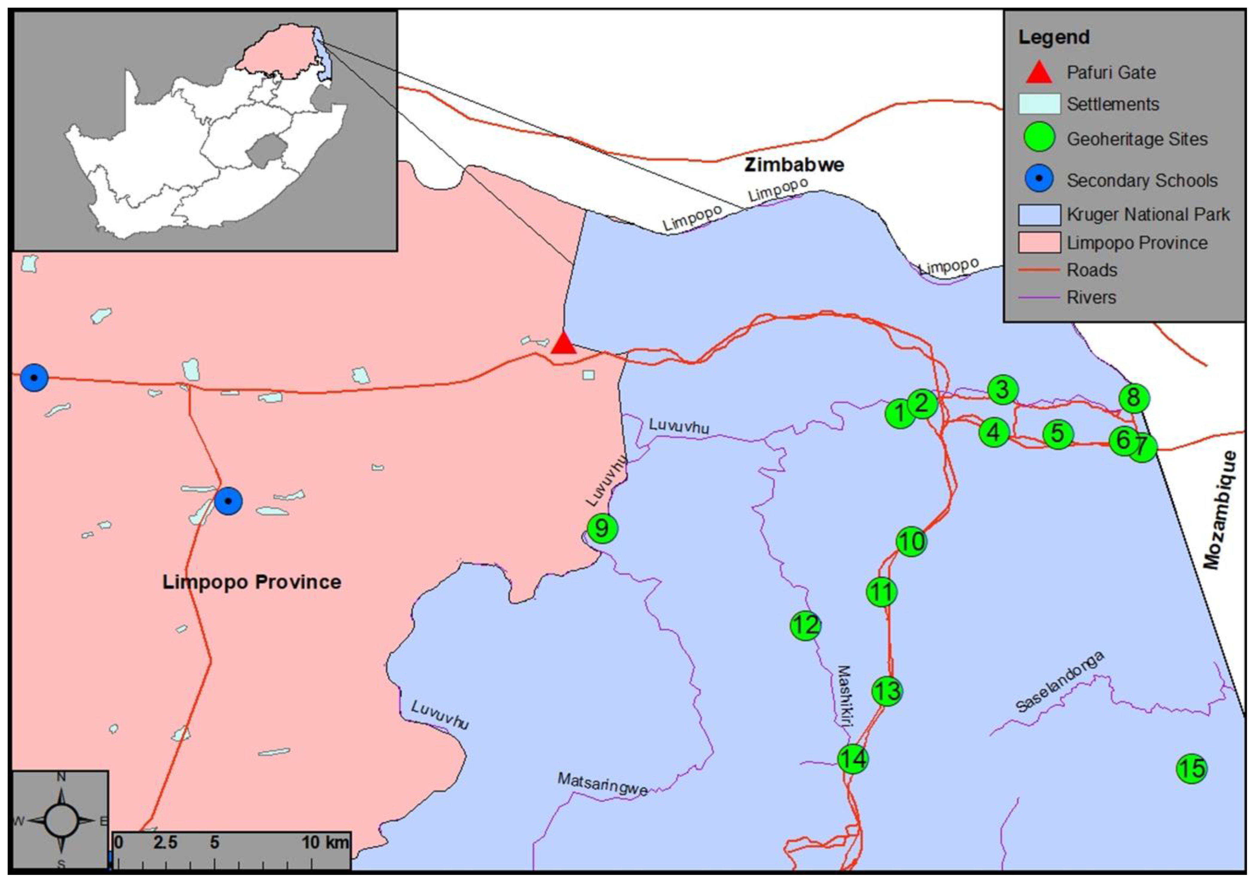
Figure 1.
Map of the northern part of KNP indicating the study area, geoheritage sites and abutting communities. 1, Thulamela; 2, Bobomeni Waterfall; 3, Old Pafuri Tent Camp; 4, Basalt Boulder; 5, Shaluka; 6, Botchers Store; 7, Wenela; 8, Crooks Corner; 9, Makahane; 10, Baobab Hill; 11, Nkovakulu; 12, Mashikiri; 13, A basalt sofa; 14, Kremetart; 15, Malonga Diamond Prospecting Pit.

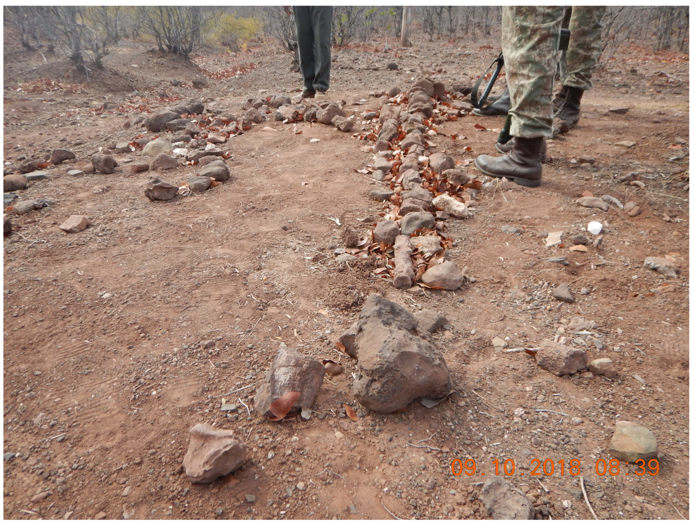
Figure 2.
Picture of incomplete and damaged dinosaur bones due to theft inside the Kruger National, indicating human-induced geoheritage threats.
Figure 2.
Picture of incomplete and damaged dinosaur bones due to theft inside the Kruger National, indicating human-induced geoheritage threats.

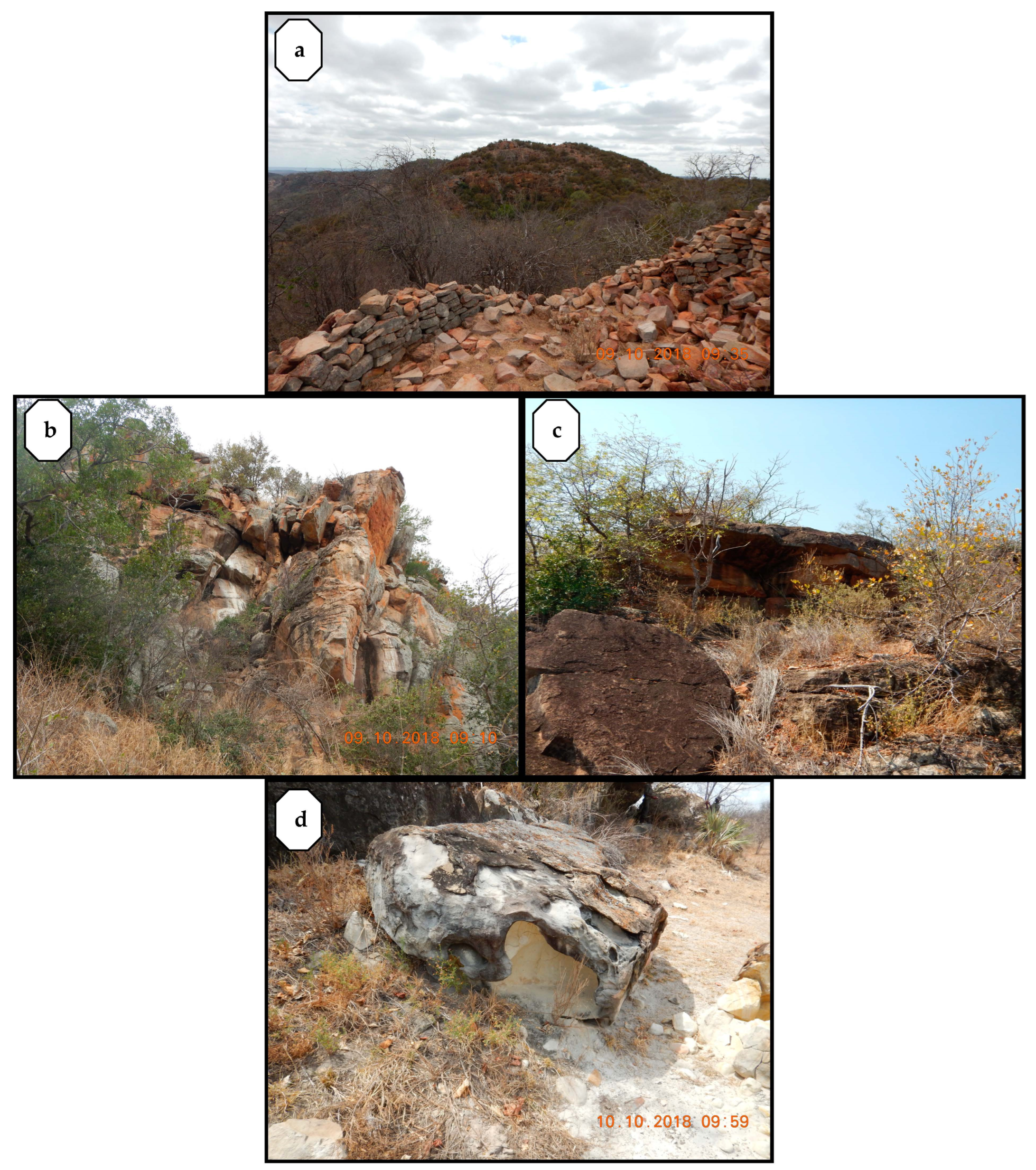
Figure 3.
Pictures indicating nature-induced geohetitage threats inside the KNP. (a) Collapsed stone wall due to floods at Makahanegeoheritage site; (b) Unstable sandstone boulders above the Makahane cave showing susceptibility to rock falls; (c) Vegetation encroachment at Kremetart; (d) Erosion of sandstone at Mashikiri.


Table 1.
Participants interviewed and their summarised view on the threats to geoheritage.
| Participant Group | |||||||
|---|---|---|---|---|---|---|---|
| Types of Threat | Government | Representatives of Local Communities | Local Residents | Tourism Agency | Tour Operators | High School Teachers | |
| Human threats | √ | √ | √ | √ | √ | √ | √ |
| Natural threats | √ | √ | √ | √ | √ | X | √ |
Disclaimer/Publisher’s Note: The statements, opinions and data contained in all publications are solely those of the individual author(s) and contributor(s) and not of MDPI and/or the editor(s). MDPI and/or the editor(s) disclaim responsibility for any injury to people or property resulting from any ideas, methods, instructions or products referred to in the content. |
© 2023 by the authors. Licensee MDPI, Basel, Switzerland. This article is an open access article distributed under the terms and conditions of the Creative Commons Attribution (CC BY) license (https://creativecommons.org/licenses/by/4.0/).
Share and Cite
MDPI and ACS Style
Matshusa, K.; Leonard, L. Geoheritage Threats in South African National Parks. Tour. Hosp. 2023, 4, 202-213. https://doi.org/10.3390/tourhosp4010012
AMA Style
Matshusa K, Leonard L. Geoheritage Threats in South African National Parks. Tourism and Hospitality. 2023; 4(1):202-213. https://doi.org/10.3390/tourhosp4010012
Chicago/Turabian StyleMatshusa, Khodani, and Llewellyn Leonard. 2023. "Geoheritage Threats in South African National Parks" Tourism and Hospitality 4, no. 1: 202-213. https://doi.org/10.3390/tourhosp4010012