1. Introduction
The Las Loras UNESCO Global Geopark (UGGp) has been chosen as one of the two Spanish geoparks studied under the umbrella of the IGCP-730 Project [
1]. The focus of the study is the interaction between surface water and groundwater.
The different aspects of this research are dissected in the following epigraphs where a brief summary is presented on the geology, structure, hydrogeology and the components of the geological diversity recognized in Las Loras UGGp.
2. Methodology
2.1. Las Loras UGGp Description
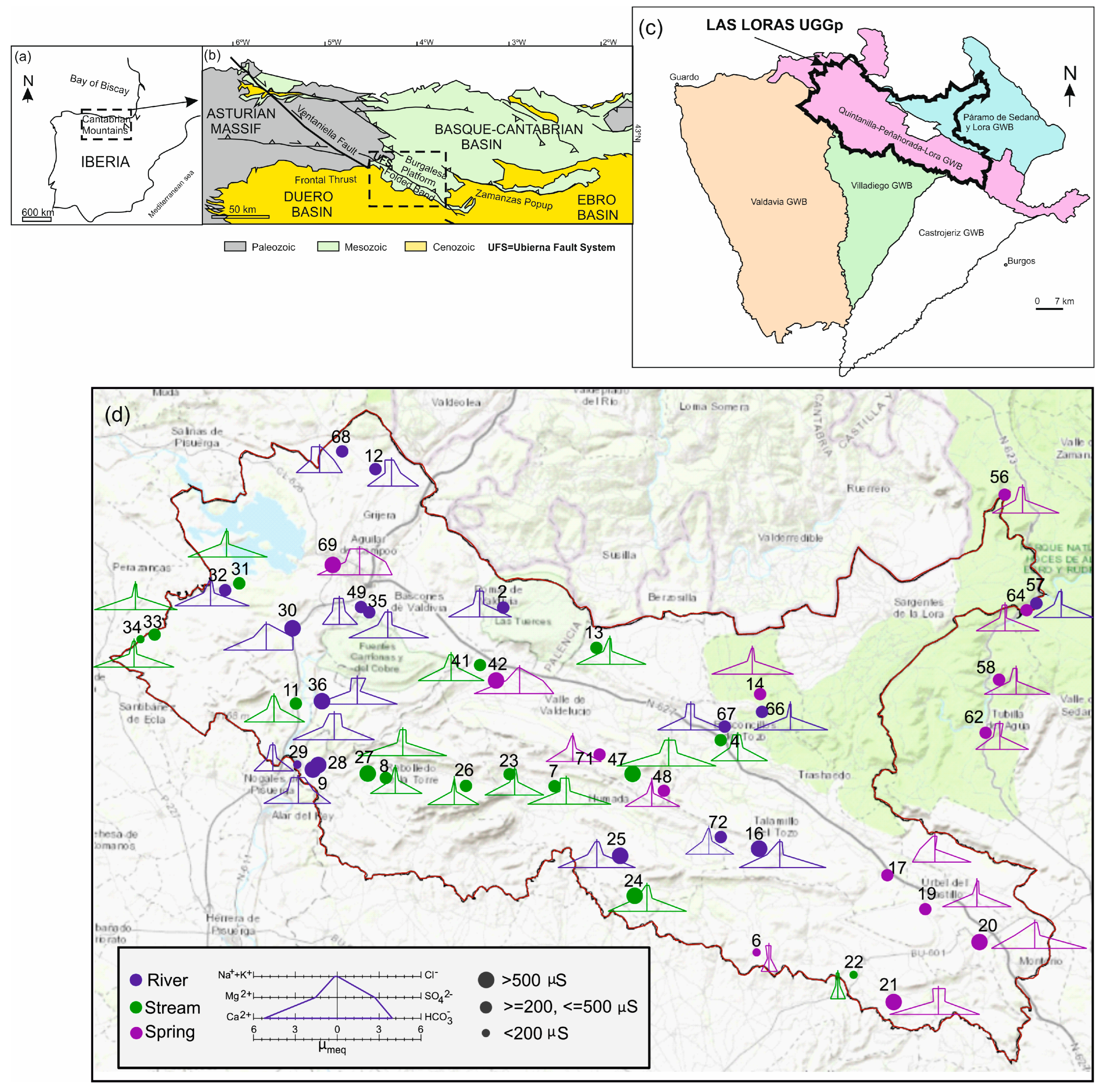
The study area has an extension of 950.76 km
2 in the provinces of Palencia and Burgos, in the north of Spain (
Figure 1) an area with 13,076 inhabitants. The Agriculture is the economic support. Some relevant industries exits in Aguilar de Campoo, and the tourist companies around the Palentina Mountain [
2].
The Ubierna Fault is the main structure which divide Las Loras UGGp into two different domains. These domains correspond to two types of folded relief (
Figure 1): (1) The Burgalesa Platform extends from the Ebro river to the Ubierna Fault, characterized by calcareous moors affected by a slight deformation. And (2) the Folded Band covers the area from the Ubierna Fault to the frontal thrust of the Cenozoic materials of the Duero basin, whose folds give name to the area, “loras”.
The sedimentary materials of Las Loras UGGp is formed by an almost complete record from the Upper Triassic to the Paleogene [
2]. The Keuper facies appears on the main faults acting as a detachment layer with high plasticity.
With regard to climate, Aguilar de Campoo (2009–2021) presents an average annual precipitation of 570 mm, with the temperature ranges between 27.08 °C in July 2013, and −4.66 °C in December 2009, being 9–11 °C the average annual temperature between 2009 and 2021.
Las Loras UGGp includes two rivers flowing into different seas: Duero, towards Atlantic Ocean; and Ebro, towards Mediterranean Sea. Within the second one, the most important rivers are the Lucio River, Rudrón River, Urbel River, and Odra and Brulles Rivers.
Hydrogeologically, the study area includes two adjoining groundwater bodies (GWBs): to the north, the Páramo de Sedano y Lora GWB, (Ebro); and, to the South, Quintanilla-Peñahorada-Lora GWB (Duero) (
Figure 1d) [
3].
2.2. Field Campaigns
46 water samples were obtained from the field campaigns.
Figure 1d show the Stiff diagram obtained for the most relevant samples for this research.
2.3. Review of Data Bases Information
Different resources available at the IGME data bases were used to explore the existence of mineral paragenesis or mining or associated with metallogenetic deposits which could be associated to the Ubierna Fault through hydrotermal activity.
2.4. Water Samples
Different field campaigns were conducted in 2021 and 2022. INAQUAS software [
4] was used for the hydrochemical information analysis and graphical representation in hydrochemical diagrams.
2.5. Compilation of Data and Intagration in a GIS
Data were compiled from literature review, and data bases consulted from different sources.
3. Results
3.1. Ubierna Fault System and Its Relationship with Potential Hydrotermalism
The Ubierna fault is the most important geological element in the study area. It presents slightly sinuous NW-SE orientation and important implications for the geomorphology, hydrogeology and groundwater and surface water interactions.
3.2. Components of Geological Diversity
3.2.1. Loras
The loras are a type of synclines subject to compression with sub-sequent erosion by Quaternary fluvial incision.
3.2.2. Moorlands
Moorlands have formed on extensive platforms of carbonate materials [
2]. They form the Páramo de la Lora de Valdivia and la Pata del Cid in the northern half of the study area. From the point of view of the extension, the moorlands may have several kilometers meanwhile the loras have a much smaller extension, in some cases, with a few tens of meters.
3.2.3. Caves
The caves appear associated with karstic environment and have been formely studied [
5].
3.2.4. Travertine Buildings
A good number of examples exist associated with active springs: Orbaneja del Castillo, Tubilla del Agua, Covalagua, Barriolucio, Hoyos del Tozo, Villaescobedo, Moradillo del Castillo, Revilla de Pomar, Rebolledillo de la Orden and Fuenteodra.
3.2.5. Peat Bogs
They appear restricted to specific examples in La Piedra, Urbel del Castillo, Humada, Fuencaliente de Puerta, Corralejo del Valdelucio.
3.2.6. Canyons and Sickles
Associated to the Ebro, Rudrón and Pisuerga valleys.
3.2.7. Sinkholes
Huron River disappear a few kilometers after its river source to birth as a new river called Rudrón River in the Cueva de Los Moros.
3.2.8. Springs
There are more than two hundred springs in the study area. The most relevant for their cultural significance are: Cueva del Agua (Orbaneja del Castillo), Pozo Azul (Covanera); nevertheless, there are others with hydrogeological relevance as Pisadera and Valdelateja due to both of them present, past or/and current symptoms of hydrothermal activity.
3.3. Main Aquifers Identified and Hydrogeological Model of Functioning
Two types of aquifers are distinguished in the study area: an permeable unconfined aquifer; and a deep confined or semi-confined aquifer [
2] made up of permeable materials of Jurassic age.
3.4. Characteristics of Some Representative Springs
The most relevant springs are shown in
Figure 1d. They could be classified in two main groups according to their geological pattern and associated aquifer formation: (a) Upper Cretaceous springs; (b) Jurassic springs.
The waters in Las Loras show an undifferentiated hydrochemical facies of bicarbonated waters. Almost all samples present a low mineralization.
4. Conclusions
The Las Loras UGGp present a high concentration of geological diversity components. The most part of them are associated to water circle shown a wide range of manifestations (springs, cave, canyons, travertine buildings, etc.) related to active processes whose action keep transforming the landscape.
The hydrogeological study carried out in this work show three types of sediments according to their behaviour: aquifers themselves, aquitards and aquifuges. An upper aquifer in the Las Loras UGGp includes materials between the Lower Cretaceous and the Quaternary. A deep regional aquifer is represented by marine Jurassic sediments. The first one, is characterized by aquifers with springs located above rivers. The deep regional aquifer is formed by confined aquifers.
Both aquifer systems do not show evidences of hydrogeological connection. The Lower Cretaceous materials acts as an aquitard that separates the upper from the deep aquifer. No signs of hydrothermalism have been recognized in the Ubierna Fault zone.
Author Contributions
Conceptualization, Á.d.l.H.-P.; methodology, Á.d.l.H.-P.; software, Á.d.l.H.-P.; validation, M.G., N.-E.L., M.C.-B., A.H.M., B.C., R.F., E.G.R., M.M.C.L., F.K.A.-G.; formal analysis, L.M.-M.; investigation, Á.d.l.H.-P., J.L.-G.; resources, M.G., J.Á.S.-F., K.S.; data curation, Á.d.l.H.-P.; writing—original draft preparation, Á.d.l.H.-P.; writing—review and editing, Á.d.l.H.-P., R.F.; visualization, Á.d.l.H.-P.; supervision, all co-authors; project administration, M.G.; funding acquisition, M.G., J.Á.S.-F., K.S. All authors have read and agreed to the published version of the manuscript.
Funding
This research was funded by UNESCO International Geosciences Programme (IGCP) and by Severo Ochoa extraordinary grants for excellence IGME-CSIC (AECEX2021).
Institutional Review Board Statement
Not applicable.
Informed Consent Statement
Not applicable.
Data Availability Statement
Data supporting reported results can be found in Ref. [
2].
Acknowledgments
The authors particularly thank the anonymous reviewer for the great contribution to the clarity and completeness of this paper.
Conflicts of Interest
The authors declare no conflict of interest.
References
- IGCP-730 Hydrogeological Significance of Mediterranean Geoparks. Available online: https://en.unesco.org/international-geoscience-programme/projects/730 (accessed on 15 January 2023).
- De la Hera-Portillo, Á.; López-Gutiérrez, J.; Moreno-Merino, L.; Llorente-Isidro, M.; Fensham, R.; Fernández, M.; Ghanem, M.; Salman, K.; Sánchez-Fabián, J.Á.; Gallego-Rojas, N.; et al. Geodiversity of Las Loras UNESCO Global Geopark: Hydrogeological Significance of Groundwater and Landscape Interaction and Conceptual Model of Functioning. Resources 2023, 12, 14. [Google Scholar] [CrossRef]
- CHD Information System. Duero River Basin Web Page. Available online: https://mirame.chduero.es (accessed on 15 January 2023).
- Moreno and De la Losa. Interpretación de Análisis Químicos de Aguas Subterráneas Mediante la Hoja INAQUAS. Luis Moreno Merino, Almudena de la Losa Román, Amalia Romero Prados, Sergio Carro Martín. 2016. Available online: https://www.igme.es/Publicaciones/Consulta/Libro/36830 (accessed on 15 January 2023).
- Rioseras, M.; Acha Alarcía, J.; Grupo Espeleológico Edelweiss. Cavidades de Orbaneja del Castillo I. El Conejal-Entrecaminos-Pico Resanquillo; Valle de Sedano: Burgos, Spain, 2016; pp. 12–33. Available online: http://grupoedelweiss.com/pdf/Cubia20.Orbaneja_I.pdf (accessed on 15 January 2023).
| Disclaimer/Publisher’s Note: The statements, opinions and data contained in all publications are solely those of the individual author(s) and contributor(s) and not of MDPI and/or the editor(s). MDPI and/or the editor(s) disclaim responsibility for any injury to people or property resulting from any ideas, methods, instructions or products referred to in the content. |
© 2023 by the authors. Licensee MDPI, Basel, Switzerland. This article is an open access article distributed under the terms and conditions of the Creative Commons Attribution (CC BY) license (https://creativecommons.org/licenses/by/4.0/).


 ,
, 
