

Hydrological Characteristics of the Bakony Region (Hungary)


Department of Geography, Eötvös Lóránd University, 9700 Szombathely, Hungary
Eng 2023, 4(1), 581-601; https://doi.org/10.3390/eng4010035
Submission received: 13 December 2022
/
Revised: 3 February 2023
/
Accepted: 8 February 2023
/
Published: 10 February 2023
(This article belongs to the Section Chemical, Civil and Environmental Engineering)
Abstract
:In this study, the karst systems (karst types) of the Bakony Region are classified and described. The karst features and the groundwater (karstwater) flow, their horst (block) types and the hydrological cycle of horst types were taken into consideration. In the mountains, regional flow with a hypogene branch (hypogene karst system) and epigene karsts systems of local flow were distinguished. Among local epigene systems, epigene karst system, mixed epigene karst system, complex mixed epigene karst system, incomplete epigene karst system and semi-closed epigene karst system were distinguished. Local epigene systems are only temporarily (but not all of them) separated from the regional system that developed below and around them. During their development, separated local systems are more and more becoming the descending branches of regional systems.
1. Introduction
Karst systems may be regional (with hypogene branch) or local epigene systems [1,2]. In the area of the Bakony Region, both flow systems occur, but local epigene systems are various. This study deals with the latter: the epigene karst systems of the Bakony Region are described, classified and characterised.
A comprehensive interpretation on the karstification of karst areas can be provided by the description of their karst hydrogeology. Features and feature assemblages develop along flow and percolation paths. They go along the whole karst or in local development on their geologically morphologically separating part. Thus, for example, in sites where there is impermeable intercalation above the main flow system, a locally individual flow system develops.
Epigene and hypogene karst types are distinguished with consideration of their flow systems [1,2]. The features and feature assemblages of epigene karsts develop along local flow systems and along the descending paths of regional systems. Feature assemblages of hypogene karsts occur along ascending paths of regional systems, but their distribution is local [3]. Here, feature development is influenced by several factors, including their joint effect [1], thus mixing corrosion, sulfuric acid, dissolution by condensed water and CO2 of metamorphic origin [4,5,6,7]. There is a strong genetic relation between surface karst features and the flows of epigene systems, which exert their effect through the epikarst, but the latter also affect cavity formation and cave development, even in case of phreatic caves. The role of regional flow systems may appear in the development of surface karst features at their descending branches. Although the ascending branch of flows does not influence the development of surface karst features, it affects the formation of subsurface karst features (this is true with the exception of collapse dolines, which may also develop by the collapse of cavities related to ascending flows).
In the Transdanubian Mountains and in particular, in the area of the Bakony Region, several regional and local flow systems can be distinguished, to which different karst systems belong. The various regional flow systems can be explained by the magmatism occurring at some sites of the area of the Transdanubian Mountains, and by the different heat flux occurring in the area of the surrounding basins. The diversity of local flows can be traced back to the different geological build-up (mainly to the intercalation of impermeable beds within the karstified limestones), to the dissection of the mountains into blocks and to their different development and different present altitude.
2. Characteristics of the Mountains
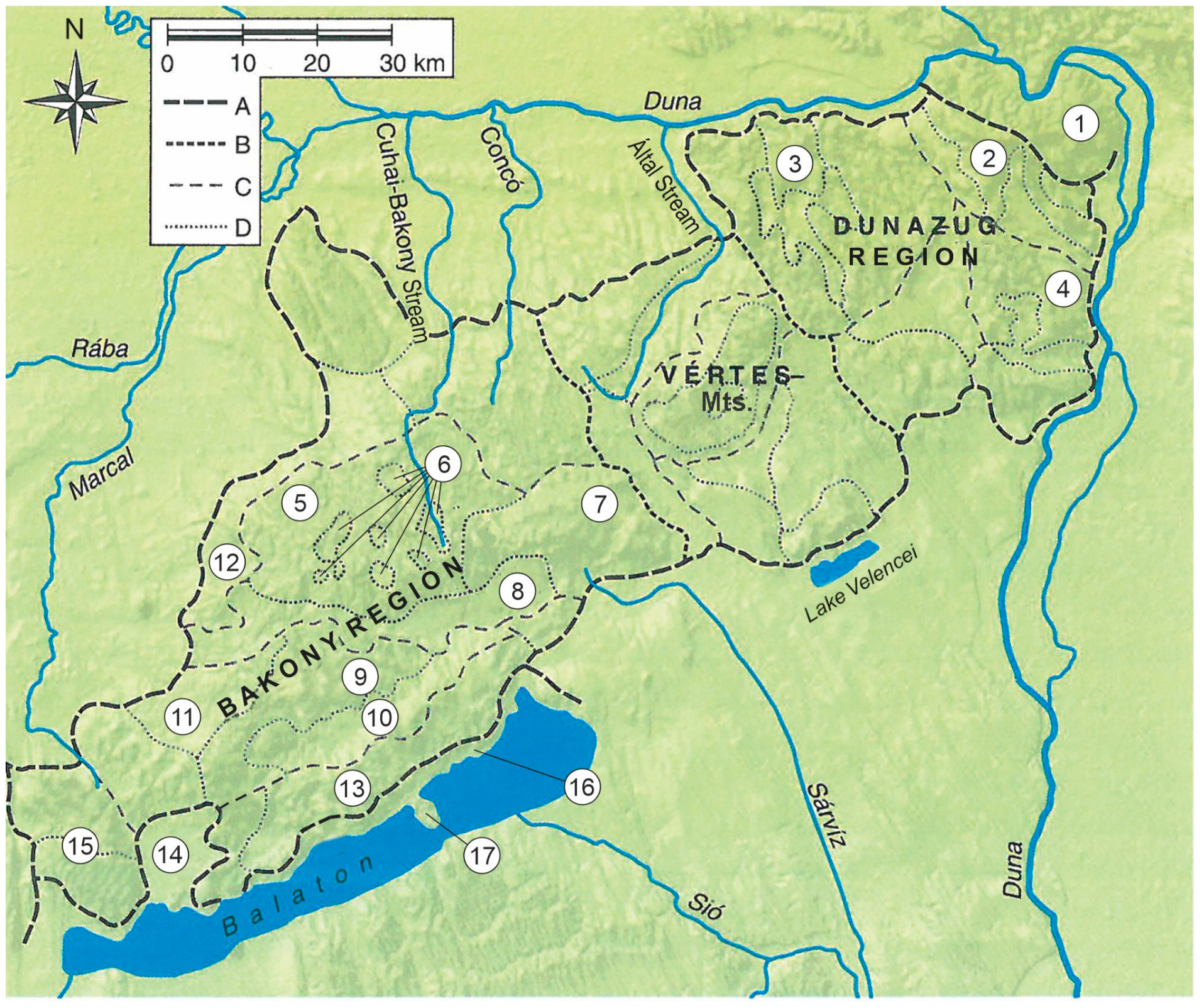
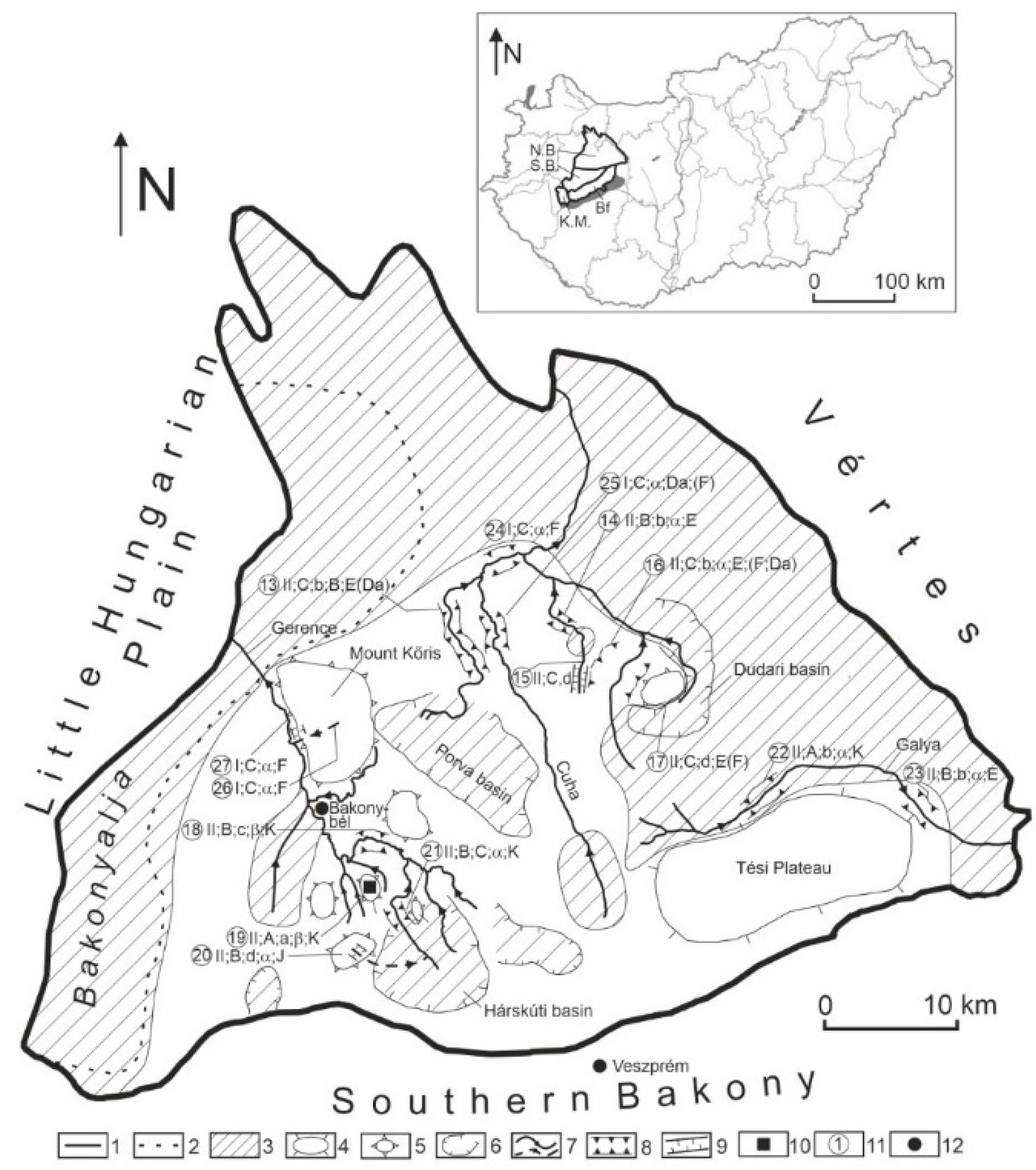
This study describes the effect of mining on the karst of the Bakony Region, which is the southwestern part of the Transdanubian Mountains. It is surrounded by the Little Hungarian Plain to the NW, by Lake Balaton to the SE, and the micro-regions of the Balaton Basin (Balaton Riviera, Tapolca Basin), the Great Hungarian Plain (Mezőföld) and the Vértes Mountains to the NE (and Mór Graben with graben structure). Its elevation is 150–700 m and its area is 4300 km2. Its largest area is the Bakony Mountains (2200 km2). Parts of the Bakony Region are the Keszthely Mountains, Northern Bakony, Southern Bakony, Balaton Uplands and Bakonyalja (Figure 1).
They are peneplain, faulted mountains, whose area became a peneplain by karstification in a tropical climate lasting from the Upper Jurassic to the Lower and Middle Cretaceous [9], then became separated into blocks along faults from the end of the Cretaceous [9]. Blocks with oscillating movement became covered by Oligo–Miocene gravel and Eocene limestone during their subsidence.
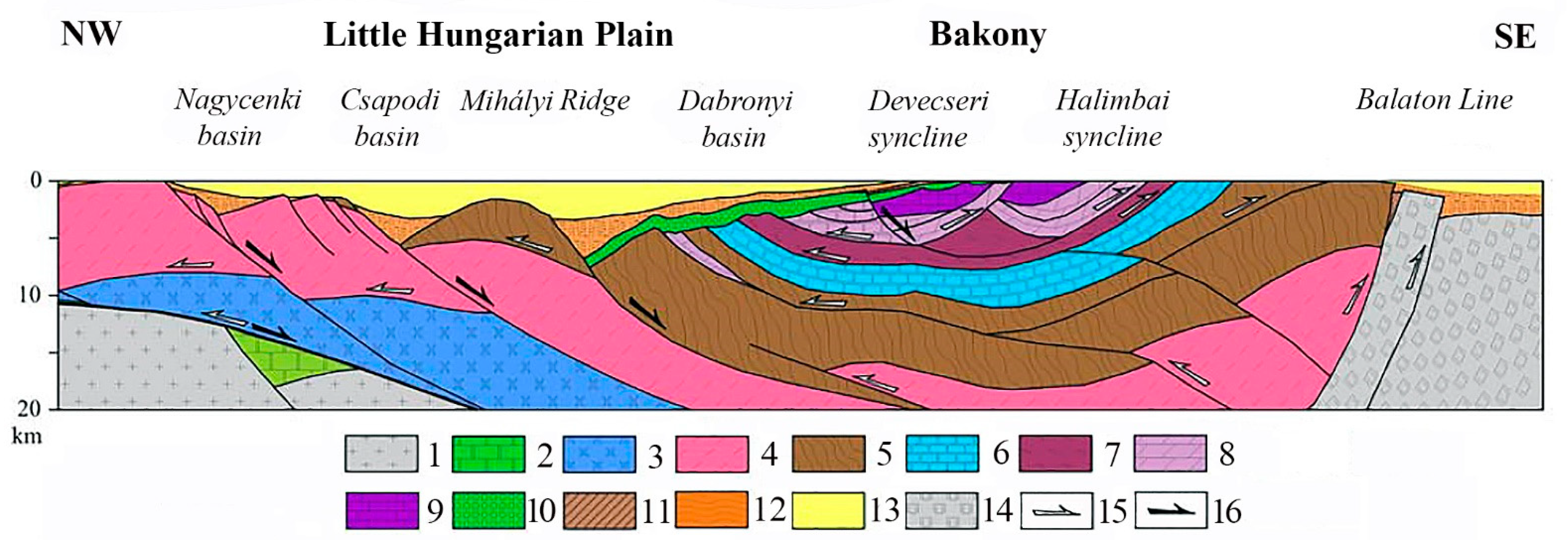
Their main constituting rock is Triassic Main Dolomite (Main Dolomite Formation), with a thickness exceeding 1500 m [10]. In the Bakony Region, the bedrock is the Veszprém Marl (Veszprém Marl Formation) which here constitutes a syncline [11] (Figure 2). The main dolomite is overlain by Triassic, Dachstein, Jurassic, Cretaceous and Eocene limestone in patches [11,12,13,14]. Young beds of the mountain margins are Middle-Miocene limestone (Lajta Limestone Formation) [13,14]. Non-karstic rocks also occur in the mountains and Middle-Oligocene–Lower Miocene delta gravel (Csatka Gravel Formation) [11,13,15] and Pleistocene loess are also widespread.
Jurassic, Cretaceous and Eocene limestone may be disrupted by impermeable beds or beds with poor permeability, particularly in the Bakony Region: silica, clay, clayey limestone, marl, calcareous marl, abrasive pebble and coal beds [16] (Figure 2).
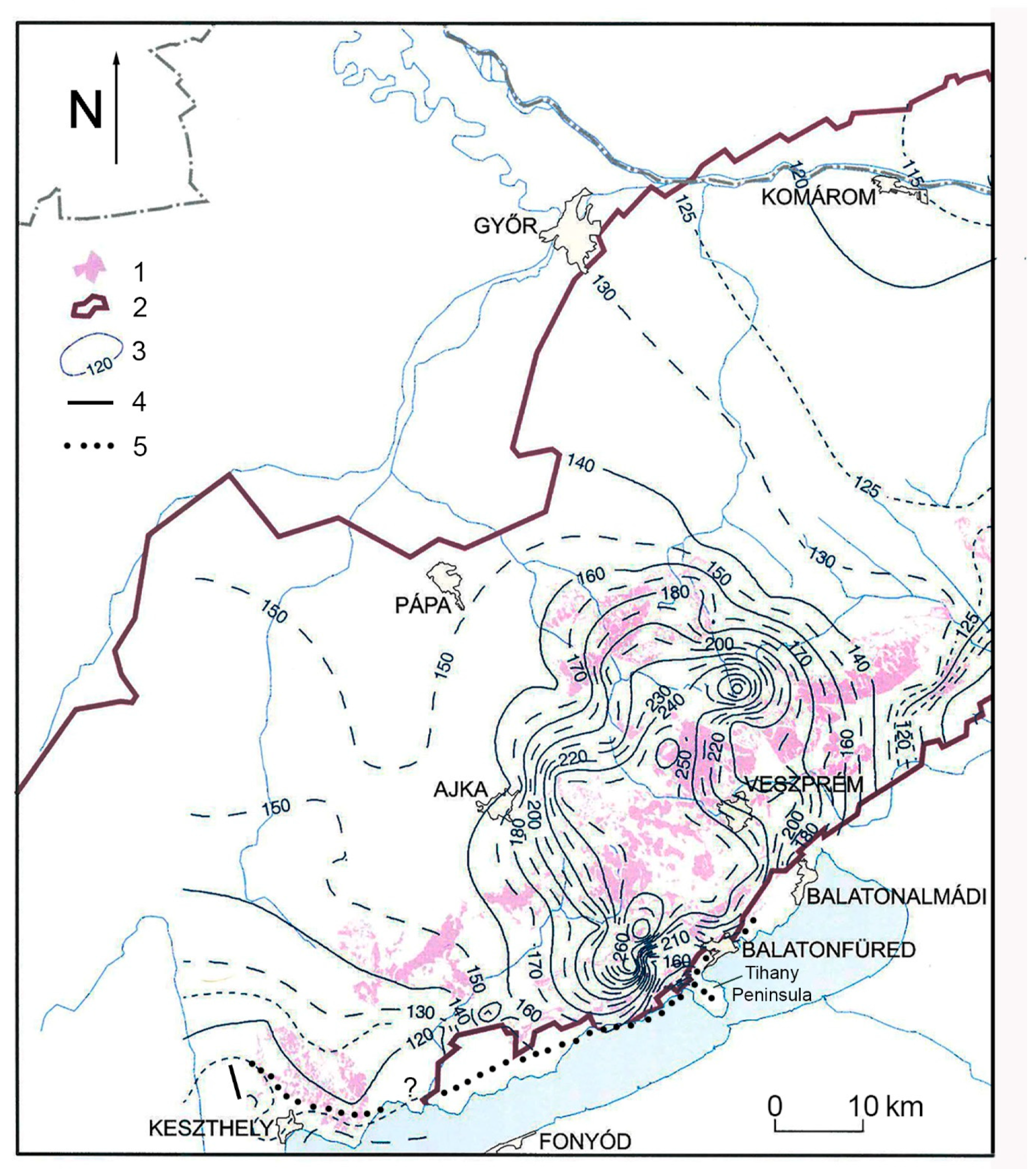
The regional groundwater of the mountains (which is expanded in the whole Transdanubian Mountains) that is called the main karstwater in Hungary mainly developed in the main dolomite and fed karst springs, karstic swamps and lakes (Lake Balaton) [17,18]. However, the groundwater is also transmitted into the basins of its environs [19,20] (Figure 3).
In the Bakony Region, where impermeable intercalations are mainly in the Middle-Eocene limestone (Szőc Limestone Formation) and in Cretaceous limestone, in some blocks and block groups [21,22], therefore, individual groundwater bodies developed above the regional groundwater. Hungarian researchers used the term karstwater storey [21,22] and floating groundwater [23]. In the international literature, the term “perched water table” is used. In the following, the terms perched water table and karstwater storey are used. Particularly, the percolating water of the gorges of the Bakony Mountains [21,24] may significantly feed the perched water table; however, at sites where the aquifuge is absent or has already become exposed by erosion, it feeds the regional groundwater and the karst aquifer [25].
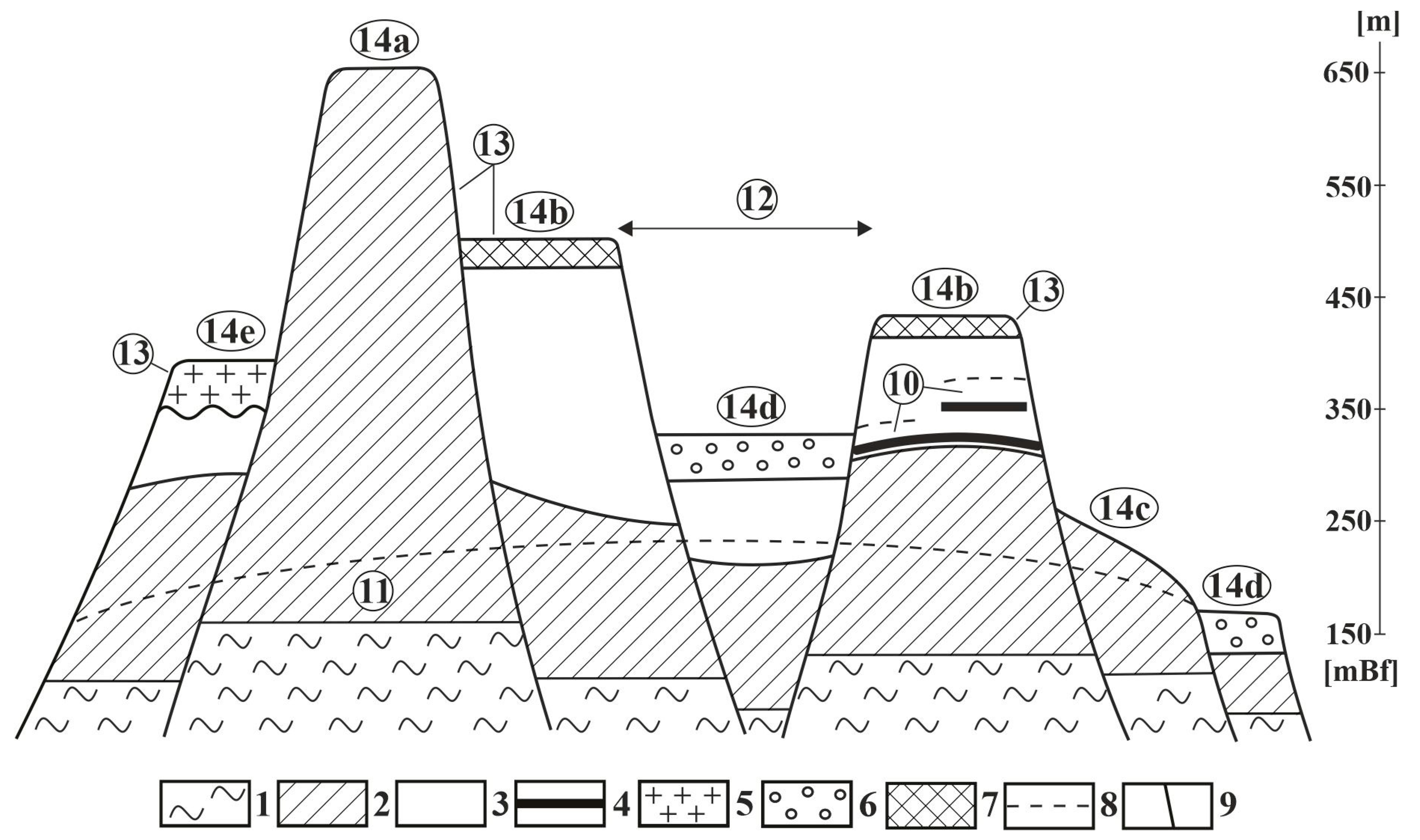
As the mountain blocks were subjected to oscillating movements since the Late Cretaceous, Pécsi [9] put them into different development types (Figure 4).
He distinguished cryptopeneplain (surface altitude is below 300 m, covered with non-karstic impermeable rocks, morphologically basin), low-threshold surface (surface altitude is below 300 m, its surface is built up of Triassic carbonates), horst elevated to summit position (surface elevation is 400–550 m, constituting rocks are Cretaceous and Eocene limestone, on which permeable mainly loess accumulations are found, morphologically mountain), horst in summit position (surface elevation is 600–700 m, Triassic and Jurassic carbonates are widespread at its surface, cover only occurs in patches) and horst type with basalt cover (covered with basalt and widespread loess). Figure 5 describes the water yield of different horst types (Figure 5).
Surface karst developed in larger and smaller patches. Features of covered karst (mainly on Tés Plateau) are subsidence dolines (suffosion dolines). Varieties of subsidence dolines are suffosion dolines, dropout dolines (cover collapse sinkholes), compaction dolines and sagging dolines. Subsidence dolines develop during the material loss of the cover. Suffosion dolines develop by suffosion, dropout dolines are formed by collapse and grain fall, compaction dolines develop by cover compaction and sagging dolines (sinkholes) are formed by the warping of the cover, but in addition to suffosion, the above processes may take part more or less in the development of suffosion dolines [26]. Features of soil-covered karst are solution dolines on Tapolca Karst and on the dolomite in the environs of Veszprém [26] (Veress 2022). Collapse dolines occur on Tapolca Karst [27], and caprock dolines occur on the basalt of Kab Hill and ponors with blind valleys [28,29,30]. Epigenetic-antecedent gorges are specific representatives of the karst of the mountains [30] at which water inlet takes place into the karst [21,24].
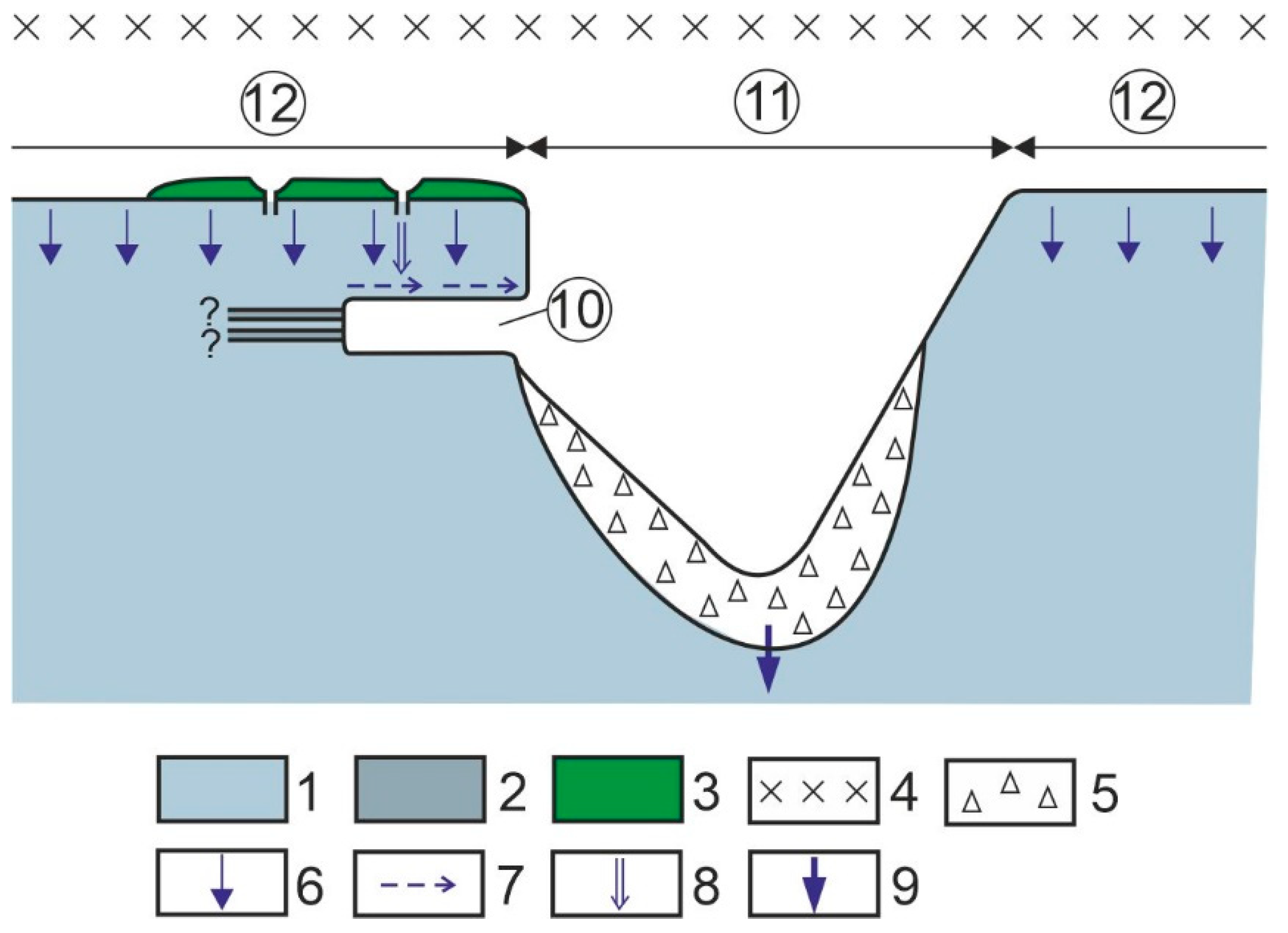
Figure 4.
Block types of the mountains [31] (modified) based on [9,10]. 1. Non-karstic rock, 2. Triassic carbonates, 3. Jurassic, Cretaceous and Eocene limestone, 4. Impermeable intercalation, clay, marly limestone, silica, etc. 5. Basalt, 6. Gravel, 7. Loess, 8. Karst water table, 9. Fault, 10. Perched water table, 11. Main karst water, 12. Basin, graben, 13. Mount, 14a. Horst in summit position, 14b. Horst elevated to summit position, 14c. Threshold surface, 14d. Cryptopeneplain, 14e. Block covered with basalt.

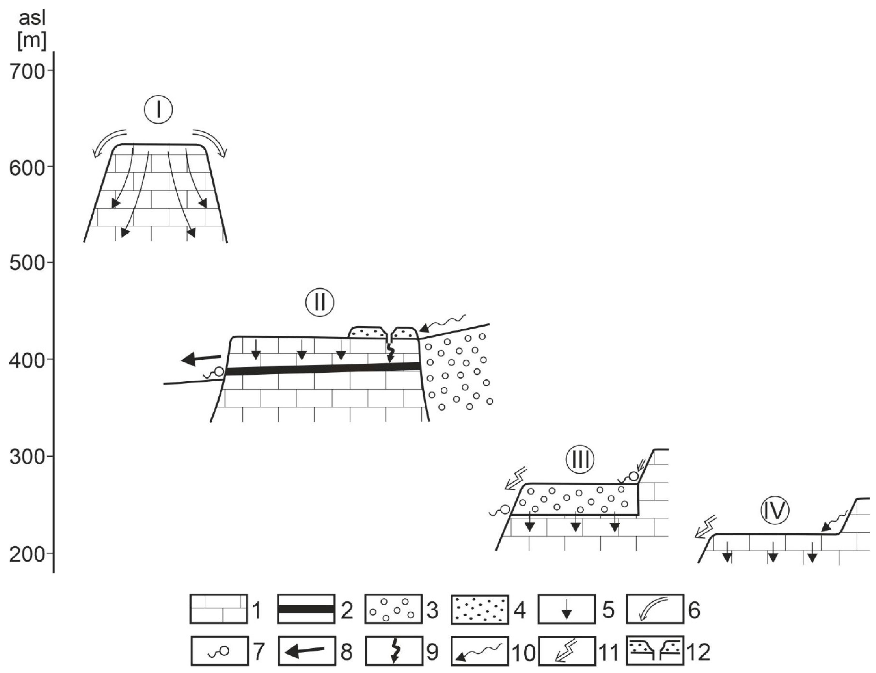
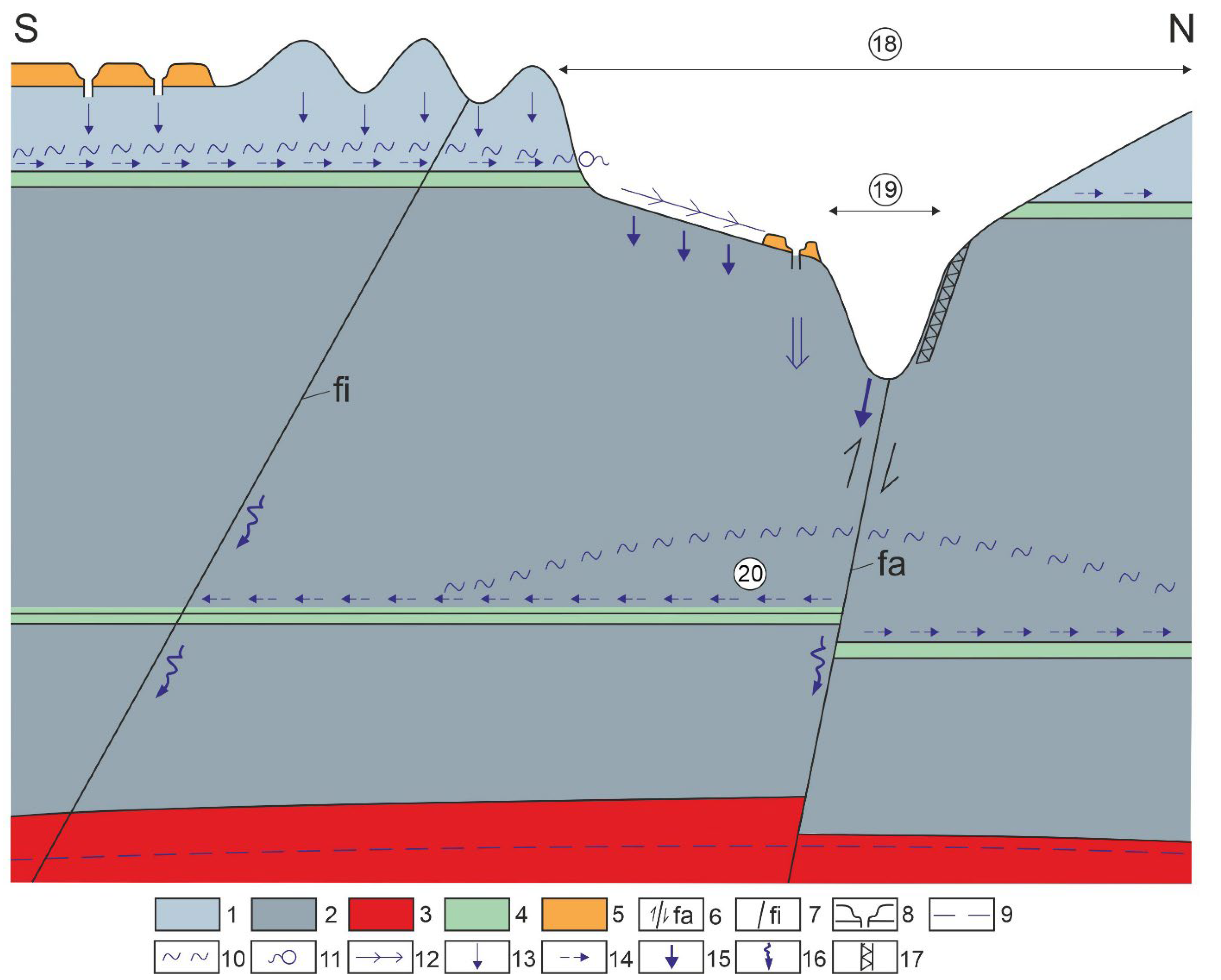
Figure 5.
Hydrological cycle of block types. Legend: I. water discharging block (horst in summit position), II. water transmitting block (horst elevated to summit position), III–IV. water catchment and water discharge block (cryptopeneplain threshold surface), 1. Carbonate rock, 2. Impermeable intercalation, 3. Non-karstic aquifer and impermeable rock, 4. Permeable sediment, 5. Areal seepage, 6. Outflow through dry valleys, 7. Spring, 8. Through-flow in dry valleys or in valleys with permanent water, 9. Local off-flow, 10. Towards-flow, 11. Outflow, 12. Subsidence doline and its shaft.

Cave entrances were developed by erosion and, thus, phreatic cavities opened up which are predominant in the Bakony Region [22,32]. They are mainly widespread in epigenetic-antecedent gorges [22]. Shafts below subsidence dolines are common [22,33], which are drainage sites and are of various patterns. Some caves of the Bakony Region, such as at the spring cave of Hévíz [34], the well caves of Cserszegtomaj [35,36,37] and the Lóczy Cave are warm water caves [38,39].
3. The Regional Flow System and the Hypogene Karst System of the Bakony Region
The descending branch of the regional system is represented by water seeping at the surface of uncovered blocks, the linear seepages of valley floors that became inherited onto the Triassic carbonate rocks. Subsidence dolines and shafts may develop above the descending branches of regional groundwater. In the regional descending branch, water inflows may occur at the shafts of subsidence dolines. Cave-ins also occur in valleys that developed in Triassic Main Dolomite. These developed from the phreatic cavities of regional groundwater since the downcutting valleys opened up the cavities that rose above the level of groundwater. An overview on caves related to the descending branch of the regional system and to the hypogene branch as well as to local flows is provided in Table 1.
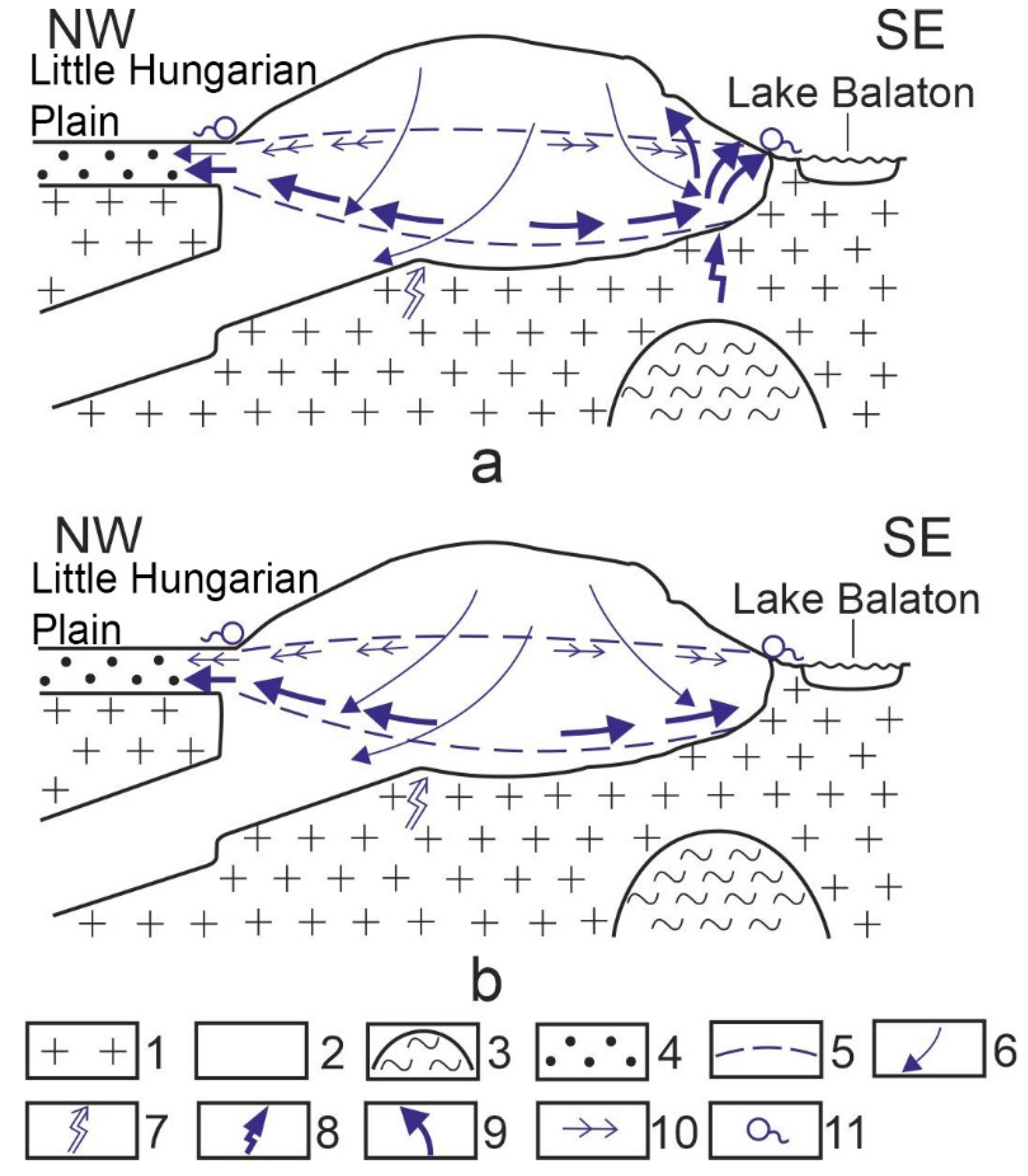
Inactive caves influenced by heat effect, such as the caves of Cserszegtomaj and the Lóczy Cave, refer to the early phase of ascending flow (which includes the water of deep karst). The caves of Cserszegtomaj developed at the interface of Triassic dolomite and Pannonian sandstone [37]; their opening onto the surface is artificial. Similarly, there were former hot water uprushes in the Tihany Peninsula which are indicated by the spring cones of the peninsula [40,41,42]. The Lóczy Cave in Balatonfüred also refers to a former hot water effect [38,39]. In the above cases, the ascending flow was triggered by the heat effect of the magma chamber of the Late Pliocene basalt volcanism (Figure 6a). In the mountains, the former hypogene branch expanded from the caves of Cserszegtomaj to the Lóczy Cave along Lake Balaton (Figure 3). Following the decrease in magma activity, the present flow system developed (Figure 6b). In the NW and SE directions, it flows into the surrounding basins and partly reaches the surface at springs [19,20,43]. It ascends at the southwestern termination of the mountains (hypogene branch). This is represented by the water of the spring cave of Lake Hévíz with a temperature reaching 40 °C degrees [35], where even the temperature of the water of the lake is 38 °C. In the Tapolca cave system (Tapolca Basin), the hypogene branch is less developed where the temperature of the water is lower (18–20 °C), but in drilling in the town of Tapolca, at a depth of 154 m, water with a temperature of 42 °C was reached [44].
4. Local Flows and Epigene Karst Systems of the Bakony Region
Local systems and their related epigene karst systems are the following: closed epigene karst system, mixed epigene karst system, complex mixed epigene karst system, incomplete epigene karst system and half-closed epigene karst system (their occurrence is presented in Figure 7). The data on the geology of the mountains and the studies on the karst of the mountains were used for the recognition and classification of epigene karst systems [22,26]. The theoretical plan views of classified epigene karst systems are described in Figure 8, Figure 9 and Figure 10, while their theoretical cross-sections are presented in Figure 11, Figure 12, Figure 13, Figure 14, Figure 15 and Figure 16. Local flow systems were detected in two ways. Present local systems can be found in sites where karst springs occur above the regional groundwater (even several hundred metres more elevated than the level of the regional groundwater). The distribution of springs determines the expansion of the karst system. Former, inactive (paleo) karst systems occur in sites where there are cave-ins above the impermeable intercalations.
Theoretical plan views of epigene karst systems that were classified based on geological data, karst morphological observations and mapping data are described in Figure 9 and Figure 10, and their theoretical cross-sections are described in Figure 11, Figure 12, Figure 13, Figure 14, Figure 15 and Figure 16.
4.1. Closed, Epigene Karst System
This system develops on horsts elevated to summit position with Middle Eocene and Cretaceous limestone, where soil-covered karst and concealed karst occur. There are no epigenetic valleys on the blocks; subsidence dolines and shafts are the features of the karst system. The waters of areal diffuse infiltration, and through the shafts, the waters of local drainage reaching the impermeable beds or along fractures and faults flows into the regional groundwater or move along. The aquifuge appear at sites where aquifuge is opened up by the stream of the valley surrounding the block (Figure 8a). The water of the springs flows down at the surface of the valley channels or flows into the regional groundwater by linear seepage (Figure 10). Such a karst system developed on Mester-Hajag (Figure 11). A younger version of this karst system occurs when the valley surrounding the block does not cut through the aquifuge. In this case, there are no springs at the margin of the block (for example, Alsó-Hajag and Égett block).
4.2. Mixed Epigene Karst System
This develops on horsts elevated to summit position with Eocene and Middle Cretaceous limestone if the horsts receive water from the area of the surrounding blocks (cryptopeneplain). On the block, permeable superficial deposit (loess) and larger and smaller patches of gravel cover (Csatka Gravel Formation) may also occur.
Water arrives at the blocks in the following way: from the surface of the blocks (with diffuse seepage), from smaller valleys of the block surface by linear seepage and through the shafts of subsidence dolines by water drainage, and from the streams of cryptopeneplains (Figure 8b). The water of the latter partially seeps away on the valley floors. If the aquifuge has not been exposed yet, a perched water table develops above the aquifuge of the block, whose water can only seep into the regional groundwater along fractures (Figure 12) (the water of the stream of the gorge partially flows down at the surface and partially seeping away also flows into the perched water table). In the perched water table, phreatic cavities develop by mixing corrosion [22].
On the rising block, the stream arriving from the cryptopeneplain creates an epigenetic-antecedent valley section (gorge) (gorges are situated on entrenched meandering valley floors). During the deepening of the gorge, the cavities of the perched water table open up, promoting its development [22,31]. If the stream cuts through the aquifuge, the perched water table loses its water, and the cavities become inactive in the environment of the valley. However, a less developed perched water table separated farther from the valley can still exist (but the small expansion of impermeable beds does not favour this). The closed system becomes open (Figure 13). From this time, the seeping water of the stream directly flows into the regional groundwater (it may happen that on the floor of the gorge, not only seepage takes place, but the water flows into open passages and grikes). Open, mixed epigene systems can be found between the settlements of Dudar and Csesznek (Ördög-árok and Kőmosó gorge).
4.3. Complex, Mixed, Epigene Karst System
These systems may develop on Cretaceous limestone blocks, since several impermeable beds may exist in them and, thus, several perched water tables are formed above each other. This type has two varieties. In one of them, the upper perched water table is not active any longer and there are cave-ins in the gorge. In the other, the upper perched water table is active too (there are no cave-ins). The former variety is more common. An example for this is the Kerteskő gorge (Figure 9a and Figure 14). Here, the Gerence Stream had already opened the upper perched water table and thus, there are springs at the opened-up aquifuge whose water seeps away or flows into the Gerence Stream. The perched water table is fed by diffuse seepage and by the water flowing into the subsidence dolines. The seeping water of the stream, the water flowing into the lower subsidence dolines and the seeping water of the Gerence Stream probably feed the lower perched water table. Evidence for this is that according to Bratán et al. [23], the rise in the regional groundwater level did not reduce seepage in the gorge, since the water receiving capacity is independent of the fluctuation of the regional groundwater level. The regional groundwater may be primarily fed by the water of the lower perched water table. At the same time, in the case of a larger discharge in the gorge seepage increasing, at a discharge of 600 l/s, 75% of the water of the Gerence Stream seeped away and at a water depth of 0.6 m, a 300 l/s seepage was estimated [23]. In the side of the gorge, there are no opened-up cavities with phreatic origin (in lack of aquifuge), but shafts and pit remnants that developed in the vadose zone occur. Phreatic cavity formation may take place below the gorge floor.
4.4. Incomplete Epigene Karst System
The bearing block did not have a non-karstic outer feeding area (and it does not have any either), or if it did, it lost it very early. Since impermeable beds occur in the Eocene and Cretaceous (maybe Jurassic) limestone of the block roof, perched water tables can develop. The developing perched water table can only be fed by the seepage waters in the area of the block (areal diffuse seepage, from the water of the shafts of the subsidence dolines, from the seepage water of the waters with low discharge of the valleys that developed in the area). Because of the above, the expansion of the perched water table and the extent of its cavity formation is insignificant. On such blocks, since they had impermeable cover, epigenetic valleys developed. A longitudinal valley is formed if the direction of the valley coincides with the dip direction of the block (Figure 8, epigenetic-regression valley), and a transverse valley develops if the block does not dip (Figure 8d). In this case, a valley develops at the block margin of the large elevation difference, which may retreat to a small degree. In both cases, the valleys may have gorge-like sections. In the current state of the karst system, the valleys of the block opened up the cavities of the perched water table after their inheritance.
In its early phase, the diffuse areal infiltration is weak, and the infiltrated water reached the regional groundwater at the fractures of impermeable beds. In its mature phase, the diffuse infiltration increases (because of the denudation of the aquifuge), but linear seepage appears on the floor of the epigenetic valley of the block and local drainage in the shafts of the subsidence dolines that were formed in the remaining permeable cover (Figure 15). The epigenetic-regression variety developed on several blocks in the Bakony Region.
4.5. Semi-Closed Epigene Karst System
This developed on Kab Mountain. To the north and northwest from the basalt cover of Kab Mountain (which primarily covers Triassic main dolomite), in the Eocene and Cretaceous limestone [45], the elevation of karst springs and the water levels of the artificial shafts of the groundwater monitoring site [46] refer to a water level of 380–400 m. However, to the southwest from the basalt cover, the elevation of springs and the water level of artificial shafts [46] indicate a water level below 250 m. In the environs of Kab Mountain, the elevation of the regional groundwater level is 250 m and below. This refers to the development of a perched water table above the regional groundwater in the Eocene (maybe Cretaceous) limestone, to the north from the basalt cover. This is also proved by the fact that the water of the manganese ore wash was drained into a depression, which appeared in the Temető Valley 1.5 km away from this site about 3 weeks later [46]. Thus, the drainage cavity system developed in the cavity system of the perched water table.
Therefore, on Kab Mountain, the water of the karst bedrock partially constitutes a perched water table and partially belongs to the regional groundwater. The water of basalt terrains may flow down at the surface in valleys, or it reaches the karst through the ponors of karst marginal blind valleys (Figure 9b and Figure 16). However, ponors with blind valleys occur on epigenetic valley floors and at the karst windows in the basalt terrain [27,28,29], where the karstic rock outcrops to the surface (which are complex karst depressions morphologically). In some complex karst depressions, caprock dolines and subsidence dolines occur, which also transmit water into the karst. The water flowing into the basalt may seep into the bedrock or resurge in springs and/or flow down in the valleys, or seep away on valley floors into the karst bedrock.
On Kab Mountain, there are two flow systems and, thus, two karst systems. In the Eocene and Cretaceous limestone, the epigene karst systems are of local flows, while in Triassic carbonates, the descending branches and karst systems are of the regional system. The waters are of the local flow system and thus, the waters of the perched water table are fed by areal diffuse seepages and by the waters of local inflows (at karst marginal ponors and at subsidence dolines) and by linear seepages (Figure 16).
The descending branches of the regional system may be fed by the waters accumulating in areic complex karst depressions (ponor with blind valley, caprock doline, subsidence doline), by the water of the ponor of the epigenetic valley floor, by the linear seepage of the epigenetic valley, by the karst marginal spring, by the water of the perched water table and by the seepage water of the inflow cave that developed in it. A peculiarity of the Kab Mountain karst is that here, the regional karst system is associated with a relatively rich surface karst landscape.
5. Conclusions
Two types of regional flows can be distinguished in the Bakony Region: towards-flow and off-flow. These developed because of various geological environment and different heat effects. Karst systems belonging to certain flow types are also different from each other. The off-flow type is richer in surface karst features and poorer in hypogene caves. The towards-flow type is poorer in surface karst features and rich in hypogene caves and calcareous sinters.
The number and diversity of the local systems of the Bakony Region is great. Epigene karst systems such as the closed epigene karst system, the mixed epigene karst system, the complex mixed epigene karst system, the incomplete epigene karst system and the semi-closed epigene karst system are rich in surface and subsurface karst features. They show significant differences in the degree of their hydrodynamic connection to the regional groundwater, but complete separation from the regional groundwater does not occur in closed systems either. The flows of epigene systems during their karstic development are more and more becoming part of the regional system.
There may be features of various ages (recent active features, recent inactive features and paleokarst features) in the epigene systems of the Bakony Region. Flow systems of different types have similar surface karst features. This refers to the fact that the epikarst of epigene systems has great independence regarding its dissolution processes.
Funding
This research received no external funding.
Institutional Review Board Statement
Not applicable.
Informed Consent Statement
Not applicable.
Data Availability Statement
Data available in a publicly accessible repository.
Conflicts of Interest
The author declares no conflict of interest.
References
- Klimchouk, A.B. Hypogene Speleogenesis: Hydrogeological and Morphogenetic Perspective Special Paper No 1; National Cave and Karst Research Institute: Carlsbad, NM, USA, 2007; 106p. [Google Scholar]
- Goldscheider, N.; Mádl-Szőnyi, J.; Erőss, A.; Schill, E. 2010: Review: Thermal water resources in carbonate rock aquifers. Hidrogeol. J. 2010, 18, 1303–1318. [Google Scholar] [CrossRef]
- Erőss, A.; Mádl-Szőnyi, J. Pávai Vajna Ferenc és a hipogén barlangképződés, a budai barlangokra vonatkozó új modellek a hidrogeológiai kutatások tükrében (Pávai Vajna Ferenc and the hypogene cave development, new models on the caves of Buda in the light of hydrogeological researches). Hidrológiai Tájékoztató 2011, 85–86. (In Hungarian) [Google Scholar]
- Müller, P. A metamorf eredetű széndioxid karsztkorróziós hatása (The karst corrosion effect of metamorphic carbon-dioxide). Karszt és Barlang 1971, II, 53–56. (In Hungarian) [Google Scholar]
- Jakucs, L. A magyarországi karsztok fejlődéstörténeti típusai (Evolutionary types of Hungarian karsts). Karszt és Barlang I-II 1977, 1–16. (In Hungarian) [Google Scholar]
- Szunyogh, G. A hévizes eredetű gömbfülkék kioldódásának elméleti vizsgálata (A theoretical study of the dissolution of spherical cavities with hydrothermal origin). Karszt és Barlang 1982, II, 83–88. (In Hungarian) [Google Scholar]
- Ford, D.C.; Williams, P.W. Karst Hydrogeology and Geomorphology; John Wiley & Sons: Chichester, UK, 2007; 561p. [Google Scholar]
- Mezősi, G. The Physical Geography of Hungary; Springer: Cham, Switzerland, 2016; 334p. [Google Scholar] [CrossRef]
- Pécsi, M. A Pannóniai-medence morfogenetikája. (The Morphogenesis of the Pannonian basin). Földrajzi Értesítő 1980, 29, 105–127. (In Hungarian) [Google Scholar]
- Haas, J. A Budaörsi Dolomit Formáció, Fődolomit Formáció, Kösseni Formáció (Budaörs Dolomite Formation, Main Dolomite Formation, Kössen Formation). In Magyarország Litosztratigráfiai Alapegységei; Haas, J., Ed.; Triász, Földtani Intézet kiadványa: Budapest, Hungary, 1993. (In Hungarian) [Google Scholar]
- Budai, T.; Gy, K. Magyarország Földtana (Geology of Hungary); Pécsi Tudományegyetem: Pécs, Hungary, 2011; 102p. (In Hungarian) [Google Scholar]
- Gyalog, L. Magyarázó Magyarország Fedett Földtani Térképéhez (az Egységek Rövid Leírása) 1:100000 (An Interpretation to the Covered Geological Map of Hungary, a Short Description of the Units); Magyar Állami Földtani Intézet: Budapest, Hungary, 2005; 189p. (In Hungarian) [Google Scholar]
- Haas, J.; Hámori, G.; Jámbor, Á.; Kovács, S.; Nagymarosi, A.; Szederkényi, T. (Eds.) Geology of Hungary; Eötvös University Press: Budapest, Hungary, 2001; 317p. [Google Scholar]
- Haas, J. Geological and Tectonic Background. In Landscapes and Landforms of Hungary; Lóczy, D., Ed.; Springer: Cham, Switzerland; Berlin/Heidelberg, Germany; New York, NY, USA; Dordhrecht, The Netherlands; London, UK, 2015; pp. 7–17. [Google Scholar]
- Korpás, L. A Dunántúli-középhegység oligocén-alsó-miocén képződményei (Oligocene-Lower Miocene features of the Transdanubian Mountains). MÁFI Évkönyve 1981, 64, 142. (In Hungarian) [Google Scholar]
- Deák, M. Magyarázó Magyarország 200000-es Földtani Térképsorozatához (An Interpretation to the 200000 Geological Map Series of Hungary) L-33-XII. In Veszprém; Magyar Állami Földtani Intézet: Budapest, Hungary, 1972; 271p. (In Hungarian) [Google Scholar]
- Szádeczky-Kardos, E. A Dunántúli középhegység karsztvízének néhány problémájáról (On some problems of the karst water of the Transdanubian Mountains). Hidrológiai Közlöny 1941, 21, 67–92. (In Hungarian) [Google Scholar]
- Papp, F. Dunántúl karsztvizei és a feltárás lehetősége Budapesten (The karstwaters of Transdanubia and the opportunity of exploration in Budapest). Hidrológiai Közlöny 1942, 21, 146–196. (In Hungarian) [Google Scholar]
- Mádl-Szőnyi, J.; Erőss, A.; Csondor, K.; Iván, V.; Tóth, Á. Hydrogeology of the Karst regions in Hungary. In Cave and Karst Systems of Hungary; Veress, M., Leél-Őssy, S., Eds.; Springer: Berlin/Heidelberg, Germany, 2022; pp. 137–160. [Google Scholar]
- Csepregi, I. A karsztvízkiemelés hatása a Dunántúli-középhegység vízháztartására (The effect of karst water extraction on the water balance of the Transdanubian Mountains). In Ányászati Karsztvízszint-Süllyesztés a Dunántúli-Középhegységben, Magyar Tudományos Akadémia; Alföldi, L., Kapolyi, L., Eds.; Földrajztudományi Kutatóintézet: Budapest, Hungary, 2007; pp. 77–112. (In Hungarian) [Google Scholar]
- Jaskó, J. A balatonfelvidéki és északbakonyi patakok vízhozamának kapcsolata a földtani felépítéssel (The relation of discharge of the streams of Balaton Highlands and Northern Bakony with geological structure). Hidrológiai Közlöny 1961, 41, 75–84. (In Hungarian) [Google Scholar]
- Veress, M. Covered Karst Evolution Northern Bakony Mountains, W-Hungary. A Bakony Természettud. Kut. Eredményei 23; Bakonyi Természettudományi Múzeum: Zirc, Hungary, 2000; 167p. [Google Scholar]
- Rónaki, L. Karsztnevezéktani javaslat (Nomenclature recommendation). Karszt és Barlang II 1970, 77–84. (In Hungarian) [Google Scholar]
- Bratán, M.; Mohos, P.; Zsuffa, I. A Gerence-patak hidrológiai tanulmánya (The hydrological study of Gerence stream). Hidrológiai Közlöny 1967, 47, 284–296. (In Hungarian) [Google Scholar]
- Schmidt Elegius, R.; Láng, S.; Gy, O. Adatok Egyes Középhegységeink Vízháztartásához (Data on the Water Balance of Some Middle Mountains in Hungary)–Vázlatok És Tanulmányok Magyarország Vízföldtani Atlaszához; Műszaki Könyvkiadó: Budapest, Hungary, 1962; pp. 48–56. (In Hungarian) [Google Scholar]
- Gutierrez, F.; Parise, M.; De Waele, J.; Jourde, H. A review on natural and human-induced geohazards and impacts in karst. Earth Sci. Rev. 2014, 138, 61–88. [Google Scholar] [CrossRef]
- Veress, M. The surface morphology of karsts in Hungary. In Leél-Őssy Sz: Cave and Karst Systems of Hungary; Veress, M., Ed.; Springer: Berlin/Heidelberg, Germany, 2022; pp. 179–248. [Google Scholar]
- Móga, J.; Kiss, K.; Szabó, M.; Kériné Borsodi, A.; Kéri, A.; Mari, L.; Knáb, M.; Iván, V. Természeti és antropogén hatások vizsgálata a Tapolcai-karszt epikarsztos rendszerében. Karsztfejlődés 2011, XVI, 185–201. [Google Scholar]
- Móga, J.; Németh, R. The morphological research of the basalt and loess covered plateaus in the Bakony Mts. (Transdanubian Middle Mts.-Hungary). Acta Carsologica 2005, 34, 397–414. [Google Scholar]
- Veress, M.; Unger, Z. Kab Mountain: Karst Under a Basalt Cap. In Landscapes and Landforms of Hungary; Lóczy, D., Ed.; Springer: Berlin/Heidelberg, Germany; New York, NY, USA; Dordrecht, The Netherlands; London, UK, 2015; pp. 55–62. [Google Scholar] [CrossRef]
- Veress, M.; Vetési-Foith, S. The Distribution of Surface Karst Features in the Bakony Region (Transdanubian Mountains, Hungary). J. Geol. Res. 2019, 1, 21–35. [Google Scholar] [CrossRef]
- Veress, M.; Vetési-Foith, S. The cave opening types of the Bakony region (Transdanubian Mountains, Hungary). Int. J. Curr. Res. 2019, 11, 3546–3552. [Google Scholar]
- Veress, M. Shaft Lengths and Shaft Development Types in the Vadose Zone of the Bakony-Mountains (Transdanubian, Hungary. J. Soil Water Sci. 2019, 3, 54–74. [Google Scholar]
- Plózer, I. A Hévízi-tó forrásbarlangjának feltárása (Exploration of the spring caves of Lake Hévíz). Karszt És Barlang I-II 1977, 65–66. (In Hungarian) [Google Scholar]
- Leél-Őssy, S. A Cserszegtomaji-kútbarlang (The well cave of Cserszegtomaj). Hidrológiai Közlöny 1953, 33, 309–313. (In Hungarian) [Google Scholar]
- Venkovits, I. Hozzászólás a Cserszegtomaji-kútbarlang című cikkhez (A remark to the article on the well cave of Cserszegtomaj). Hidrológiai Közlöny 1953, 33, 471–472. (In Hungarian) [Google Scholar]
- Kárpát, J. A Cserszegtomaji-kútbarlang (The well cave of Cserszegtomaj). Karszt És Barlang 1982, I, 35–40. (In Hungarian) [Google Scholar]
- Leél-Őssy, S. Karsztmorfológiai vizsgálatok a balatonfüredi Lóczy-barlangban és környékén (Karstmorphological investigations in the Lóczy cave in Balatonfüred and in its environs). Földrajzi Értesítő VII 1958, 3, 379–381. (In Hungarian) [Google Scholar]
- Láng, S. A Bakony geomorfológiai képe (The geomorphology of the Bakony Mountains). Földrajzi Közlemények 1958, 6, 325–343. (In Hungarian) [Google Scholar]
- Lóczy, L. A Balaton környékének geológiai képződményei és ezeknek vidékek szerinti telepedése (The geological features of the surroundings of Lake Balaton and their regional distribution). In A Balaton Tudományos Tanulmányozásának Eredményei, I.K.; Magyar Tudományos Akadémia: Budapest, Hungary, 1913; 617p. (In Hungarian) [Google Scholar]
- Hoffer, A. A Tihanyi-félsziget vulkáni képződményei (Volcanic formations of the Tihany Peninsula). Földtani Közlemények 1943, 73, 375–429. (In Hungarian) [Google Scholar]
- Kovács-Pálffy, P.; Kalmár, J.; Veress, M. A Tihanyi-félsziget algás eredetű forrásüledékeinek ásvány-kőzettani vizsgálata. (Mineralogical-petrographic analyses of spring deposits of algal origin on the Tihany Peninsula). Karsztfejlődés 2007, XII, 111–135. (In Hungarian) [Google Scholar]
- Böcker, T. A hazai karsztvízkutatás gazdasági jelentősége (Economic significance of karst water research in Hungary). Karszt és Barlang 1977, I–II, 17–22. (In Hungarian) [Google Scholar]
- Plózer, I. Adalékok a Tapolcai tavasbarlang kutatásához (Data on the research of the Tapolca Lake Cave). Karszt és Barlang 1975, I–II, 15–18. (In Hungarian) [Google Scholar]
- Vörös, I. A Kab-hegy vulkanológiai és hegységszerkezeti viszonyai (Volcanological and mountain structural relations of Kab Mountain). Földtani Közlöny 1966, XCVI, 294–300. (In Hungarian) [Google Scholar]
- Kálmán, G.; Pethő, J. Úrkút és Ajka környékének részletes karsztvíz térképe (Detailed kartswater map of the environs of Úrkút and Ajka). Hidrológiai Közlony 1950, XXX, 175–178. (In Hungarian) [Google Scholar]
Figure 1.
Parts of the Transdanubian Mountains [8]. Legend: 1. Visegrád Mountains, 2. Pilis Mountains, 3. Gerecse Mountains, 4. Buda Hills, 5. Old Bakony, 6. Small basins of Bakony, 7. Tés Plateau (Northern Bakony), 8. Veszprém–Devecser graben, 9. Kab Mountain–Agártető group, 10. Veszprém–Nagyvázsony basin, 11. Sümeg–Tapolca ridge, 12. Devecser–Bakonyalja (Southern Bakony), 13. Balaton Uplands, 14. Tapolca Basin, 15. Keszthely Mountains, 16. Balatoni–Riviera, 17. Tihany Peninsula. A. boundary of macro region, B. boundary of meso region, C. boundary of micro region group, D. boundary of micro region.

Figure 2.
Geological profile [11]. 1. European Upper Crust, 2. European autochton Mesozoic, 3. Penninic, 4. Lower, Upper and Austroalpine Paleozic 5. Uppermost Austroalpine Palozoic, 6. Lower, Middle Triassic, 7. Veszprém Marl 8. Main Dolomite, 9. Dachstein and Kardosréti limestone, 10. Gosau beds, 11. Paleogenic beds, 12. Lower, Middle Miocene beds, 13. Upper Miocene beds, 14. Paleo Mezozoic of dinaric type (Middle Hungarian Main Unit), 15. Mesozoic overthrusts, 16. Miocene dip faults.

Figure 3.
Regional groundwater of the mountains in January 2006 [20] (modified). Legend: 1. Infiltration area, 2. Boundary of groundwater storage, 3. Altitude of the isoline of groundwater level, 4. Hypogene branch, 5. Former hypogene branch.
Figure 3.
Regional groundwater of the mountains in January 2006 [20] (modified). Legend: 1. Infiltration area, 2. Boundary of groundwater storage, 3. Altitude of the isoline of groundwater level, 4. Hypogene branch, 5. Former hypogene branch.

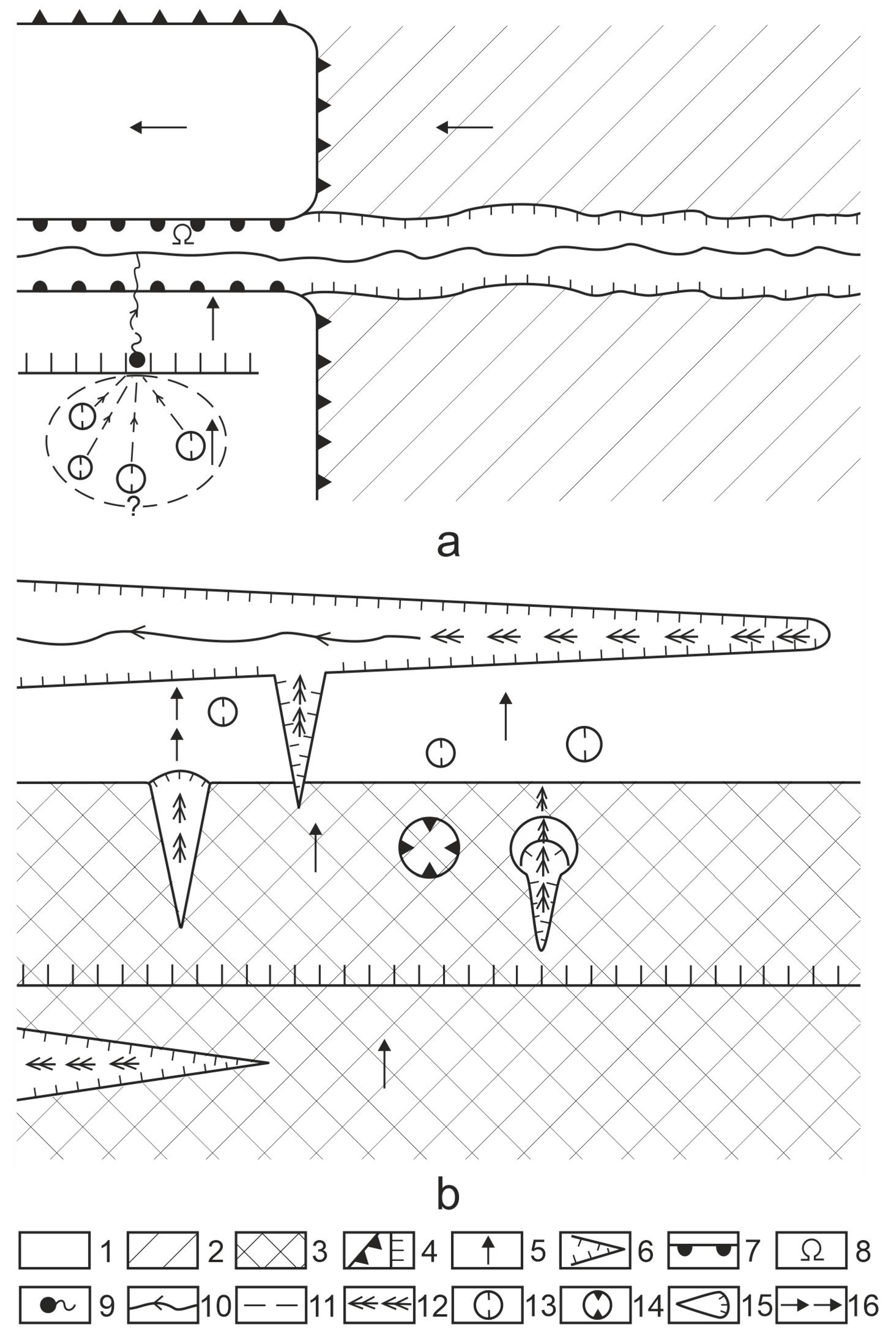
Figure 6.
Ways that groundwater is heated up in the Bakony Region (based on [19,20]). Legend: (a) Initial state, (b) Present state, 1. Non-karstic rock, 2. Carbonate rocks, 3. Melt, 4. Basin sediment, 5. Groundwater level, 6. Infiltration, 7. Groundwater heating up as a result of high heat flux, 8. Heat flow from the magma chamber, 9. Heating up and ascending flow of groundwater, 10. Groundwater flow, 11. Karst spring.

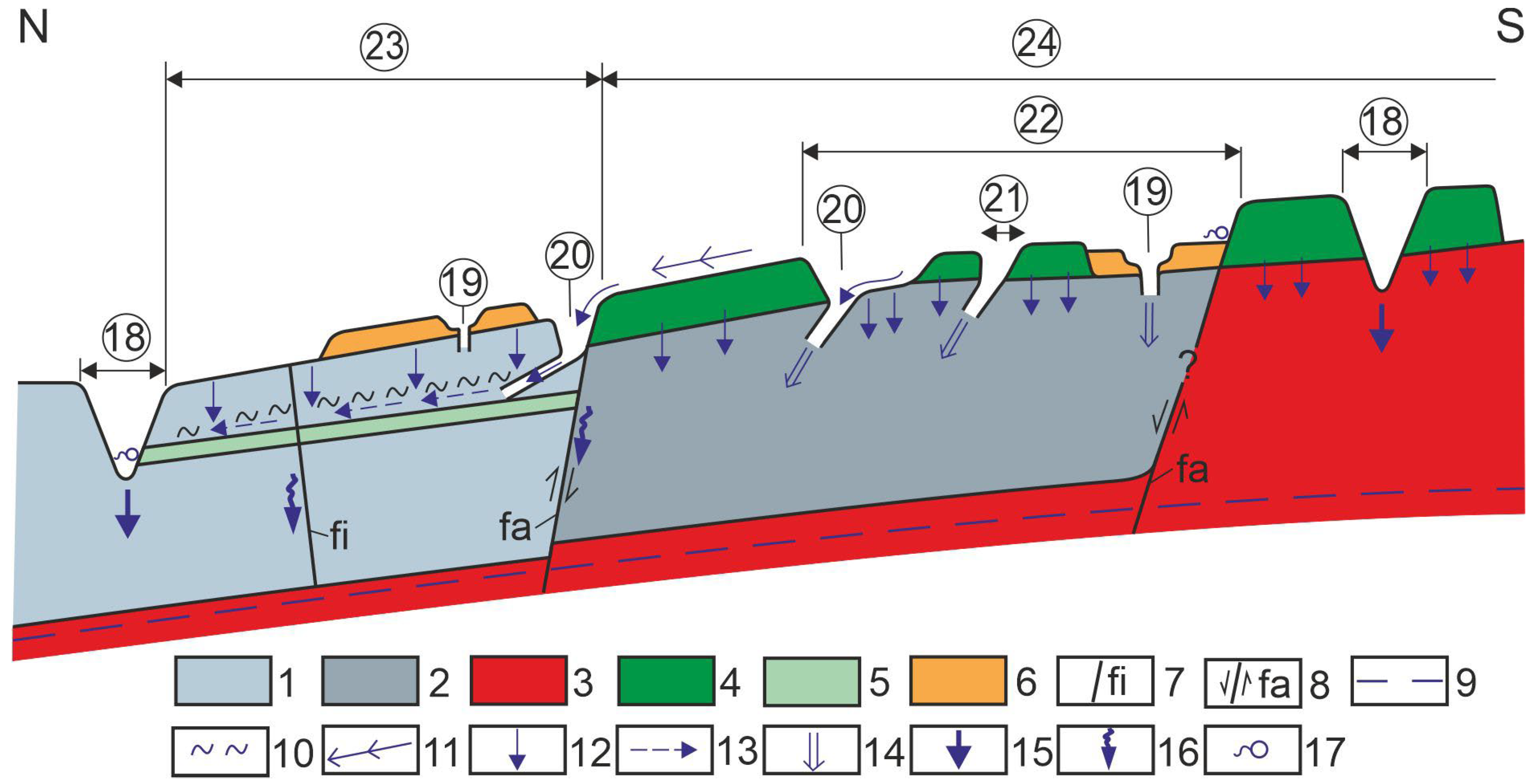
Figure 7.
Karst systems in Northern Bakony that developed in the descending flows of local and regional flows. Legend: NB: Northern Bakony, SB: Southern Bakony, KM: Keszthely Mountains, Bf: Balaton Uplands, 1. Boundary of Northern Bakony, 2. Boundary of micro region group, 3. Impermeable cover, 4. Plateau, 5. Block roof, 6. Basin, 7. Permanent and intermittent streams and their valleys, 8. Epigenetic-antecedent gorge (epigene karst system in valley), 9. Epigenetic-regression gorge, valley section with a spring (epigene karst system in valley), 10. Epigene karst system on block, 11. Identification mark of karst system, 12. Settlement, 13. Kőris block, 14. Som block, 15. Magos block, 16. Mester-Hajag, 17. Alsó-Hajag, 18. Égett block, 19. Középső-Hajag, 20. Tés Plateau, 21. Porva basin, 22. Dudar basin, 23. Lókút basin, 24. Hárskút basin, 25. Csehbánya basin, 26. Cuha stream, 27. Hódos stream, A. Juvenile system, B. Adult system, C. Mature system. a. Closed epigene system, b. Mixed epigene system, c. Complex mixed epigene system, d. Incomplete system, e. Semi-closed epigene system. E. Middle Eocene limestone, K. Cretaceous limestone, J. Jurassic limestone, Da. Dachstein limestone, F. Main dolomite. α. There is phreatic opened-up cavity, β. Lack of phreatic opened up cavity.

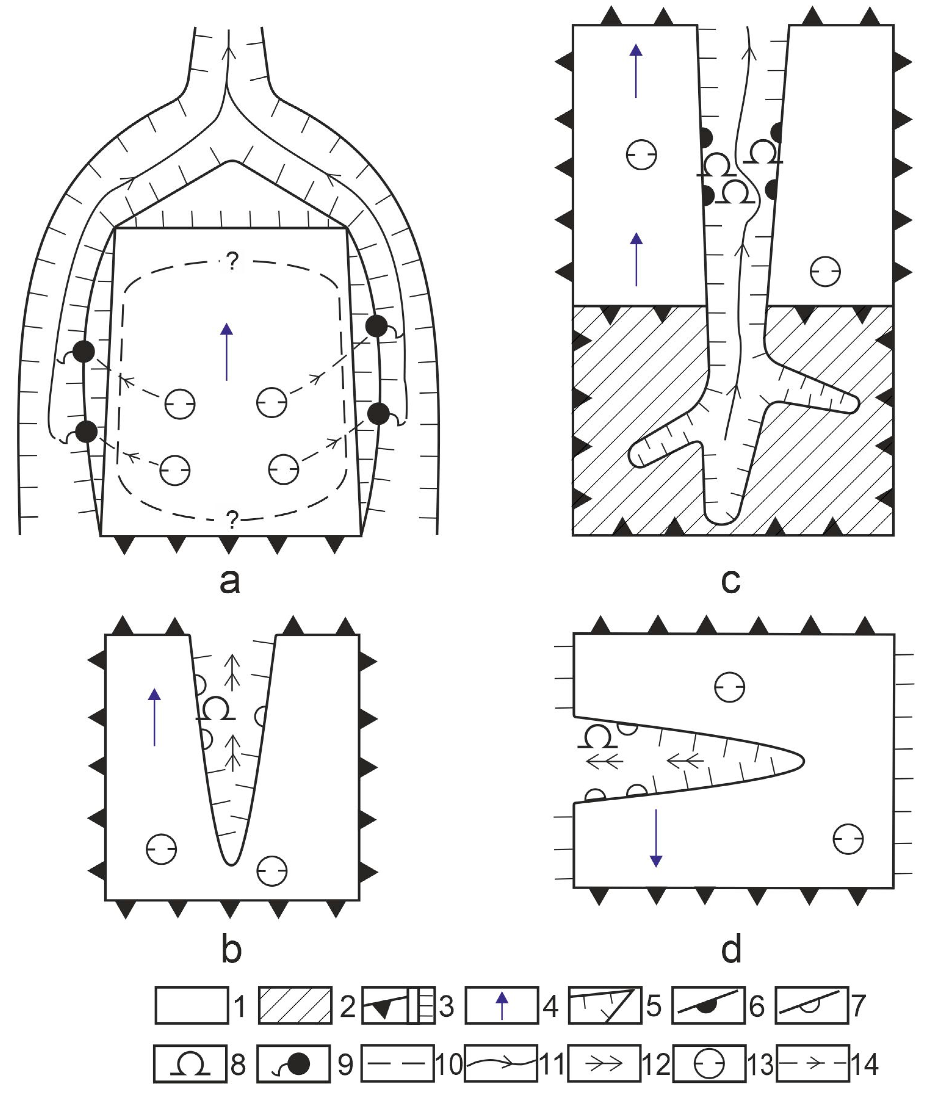
Figure 8.
Closed epigene karst system (a), mixed epigene karst system (b), incomplete epigene karst system at valley coinciding with block inclination (c) and incomplete epigene karst system in the case of valley situated anti-dip of block (d), in plan view. Legend: 1. Limestone covered with soil and permeable cover, 2. Block covered with aquifuge, 3. Fault scarp of block, 4. Dip direction of block surface, 5. Epigenetic valley, 6. Epigenetic-antecedent gorge, 7. Other valley section with gorges, 8. Cave-ins, 9. Spring, 10. Approximate boundary of perched water table, 11. Stream, 12. Intermittent stream, 13. Suffosion doline, 14. Water flow in the karst.

Figure 9.
Complex, mixed epigene karst system (a), semi-closed epigene karst system (b), in plan view. Legend: 1. Limestone covered with soil and permeable cover, 2. Block covered with impermeable superficial deposit, 3. Block covered with basalt, 4. Cuesta of block, 5. Dip direction of block surface, 6. Epigenetic valley, 7. Epigenetic-antecedent gorge, 8. Cave-in, 9. Spring, 10. Approximate boundary of perched water table, 11. Permanent stream, 12. Intermittent stream, 13. Suffosion doline, 14. Caprock doline, 15. Ponor with blind valley, 16. Water flow in the karst.

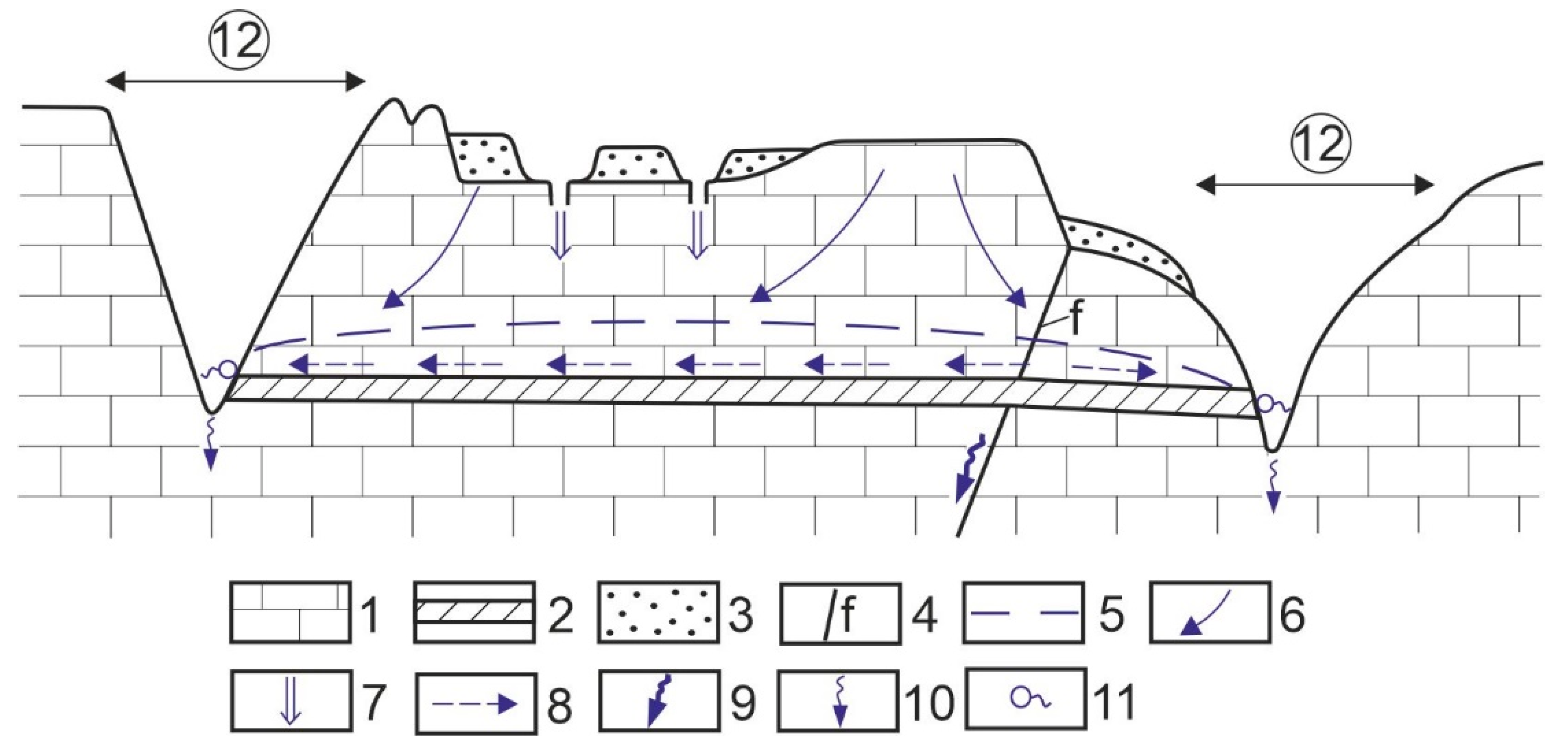
Figure 10.
Closed epigene karst system in cross-section. Legend: 1. Limestone, 2. Impermeable intercalation, 3. Permeable cover, 4. Fault, 5. Groundwater level, 6. Infiltration, 7. Local water inflow, 8. Water motion above aquifuge, 9. Water drainage along fault, 10. Linear seepage, 11. Spring, 12. Epigenetic valley.

Figure 11.
An example of a closed epigene karst system: the Mester-Hajag area and its environment (a), the distribution of surface karst features on the block (b), a section with karst features (c). Legend: 1. Contour line, 2. Mound, 3. Permanent stream, 4. Intermittent stream, 5. Karst features, 6. Section that is described in a detailed way in Figure 11c, 7. Exhumed mound, 8. Semi-exhumed mound, 9. Limestone outcrop on the mound, 10. Karstifying terrain with superficial deposit between the mounds that developed by exhumation, 11. Material reworking, 12. Occurrence of subsidence dolines (suffosion dolines), 13. Suffosion doline on terrain between mounds, 14. Depression of superficial deposit, 15. Forest boundary, 16. Forest road, 17. Farm.

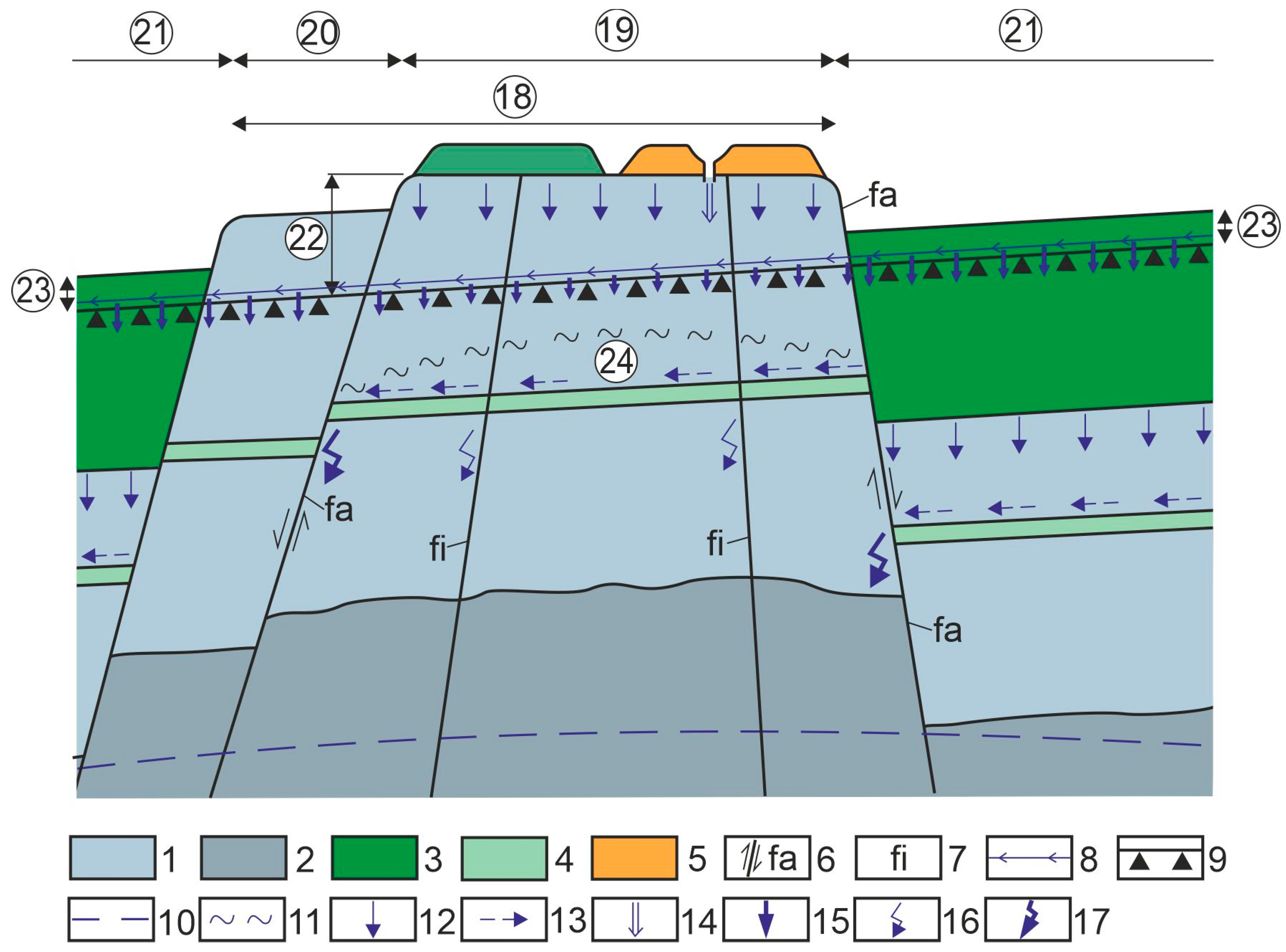
Figure 12.
Mixed epigene karst system in early phase in cross-section. Legend: 1. Young (Eocene, Cretaceous) limestone, 2. Older (Triassic) carbonates, 3. Impermeable and water storage cover, 4. Impermeable, partly impermeable intercalation, 5. Permeable cover, 6. Fault and fault scarp, 7. Fracture, 8. Stream, 9. Valley floor, 10. Regional groundwater level, 11. Level of perched water table, 12. Areal, diffuse infiltration, 13. Water motion above impermeable intercalation, 14. Local water inflow, 15. Linear seepage, 16. Water motion along fracture, 17. Water motion along fault, 18. Horst elevated to summit position 19. Epigenetic-antecedent valley section, 20. Epigenetic valley section, 21. Cryptopeneplain with inheriting valley section, 22. Side of epigenetic-antecedent valley section, 23. Side of valley section that developed in non-karstic rock, 24. Perched water table.

Figure 13.
Mixed epigene karst system in mature phase in cross-section. Legend: 1. Young (Eocene, Cretaceous) limestone, 2. Older (Triassic) carbonates, 3. Impermeable and water storage cover, 4. Impermeable, partly impermeable intercalation, 5. Permeable cover, 6. Fault and fault scarp, 7. Fracture, 8. Valley floor, 9. Stream, 10. Regional groundwater level, 11. Water level of inactive perched water table, 12. Water motion along fracture, 13. Water motion along fault, 14. Areal diffuse infiltration, 15. Water motion above impermeable intercalation, 16. Local water inflow, 17. Linear seepage, 18. Cave-in, 19. Horst elevated to summit position, 20. Epigenetic-antecedent valley section, 21. Epigenetic valley section, 22. Cryptopeneplain with inheriting valley section, 23. Epigenetic-antecedent valley side, 24. Side of valley section that developed in non-karstic rock.

Figure 14.
Complex, mixed epigene karst system in cross-section. Legend: 1. Limestone of Albian storey (Requinian limestone), 2. Limestone of Aptian storey, 3. Main dolomite, 4. Aquifuge, 5. Permeable cover, 6. Fault, 7. Fracture, 8. Subsidence doline, 9. Regional groundwater level, 10. Level of perched water table, 11. Spring, 12. Stream, 13. Diffuse infiltration, 14. Water motion above aquifuge, 15. Seepage in the channel, 16. Seepage along fault, fracture, 17. Pit remnants, 18. Epigenetic valley (Gerence valley), 19. Gorge, 20. Perched water table.

Figure 15.
Incomplete epigene karst system in mature phase in cross-section. Legend: 1. Limestone, 2. Impermeable intercalation (silica), 3. Permeable cover, 4. Former surface of the cover that denuded by present, 5. Slope debris, 6. Areal diffuse infiltration, 7. Former water motion above impermeable intercalation, 8. Local water inflow, 9. Linear seepage, 10. Cave-in, 11. Epigenetic valley, 12. Block roof.

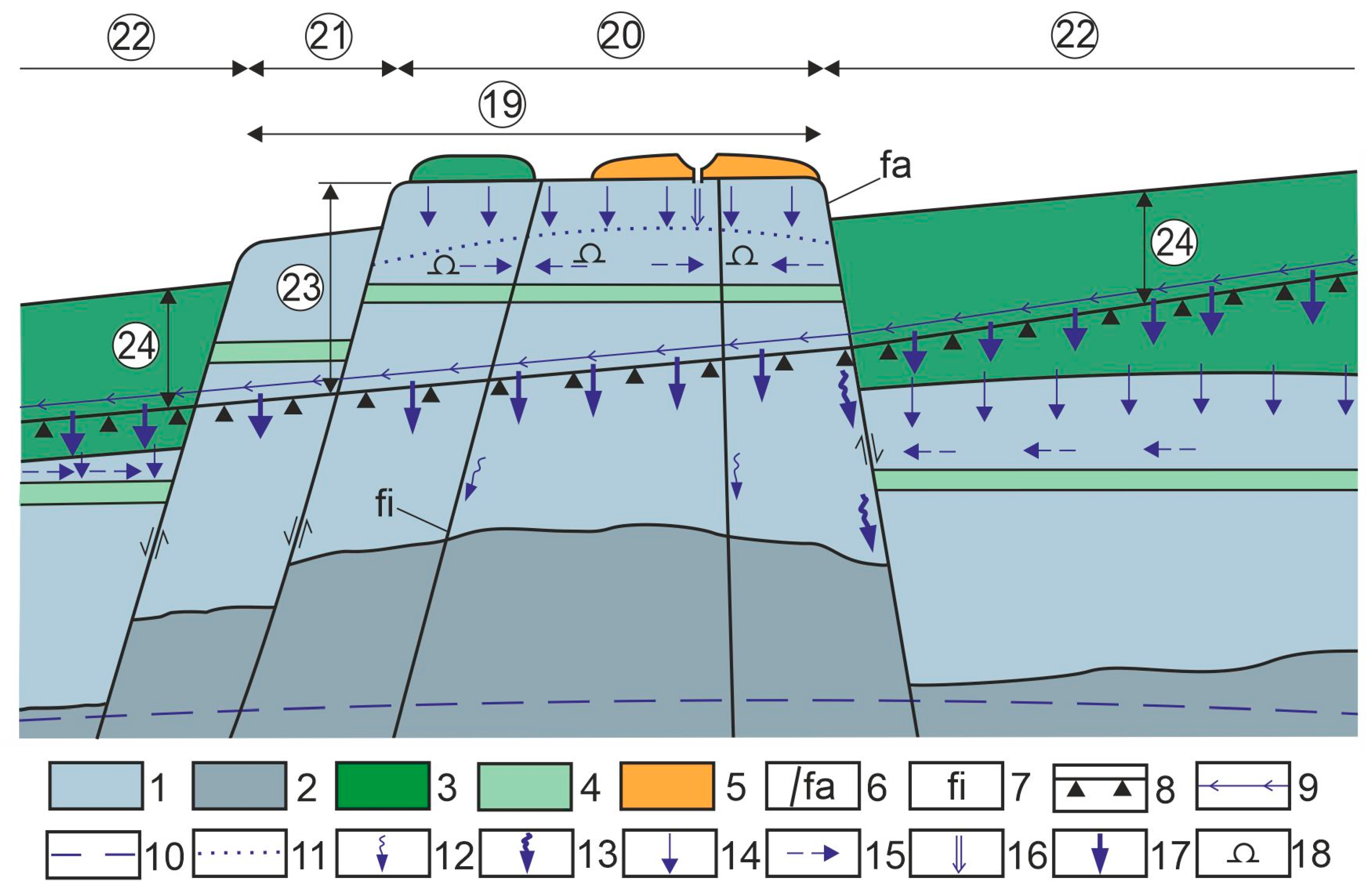
Figure 16.
Semi-closed epigene karst system in cross-section. Legend: 1. Young limestone, 2. Older (Jurassic, Triassic) limestone, 3. Main dolomite, 4. Basalt, 5. Impermeable intercalation, 6. Permeable cover (loess), 7. Fracture, 8. Fault, 9. Regional groundwater level, 10. Level of perched water table, 11. Surface stream, 12. Infiltration, 13. Water motion above impermeable intercalation, 14. Local water inflow, 15. Linear infiltration, 16. Infiltration along fracture, fault, 17. Spring, 18. Valley, 19. Subsidence doline, 20. Ponor with blind valley, 21. Caprock doline, 22. Complex karst system, 23. Epigene local karst system, 24. Epigene regional karst system.


Table 1.
The caves of the Bakony Region according to flow systems.
| Flow System | Cave Type | Cave Development | Number of Caves | Position of Caves | Occurrence Site or Name | State | Function |
|---|---|---|---|---|---|---|---|
| epigene (local flow) and regional flow, descending branch | opened-up | from the water of the perched water table | 180 (e) | valley side, horst top, horst side | Ördög-árok Valley, Kő-árok Valley, Kőmosó Valley, Valley of Dudar Stream etc. | inactive | - |
| from the cavity of the regional groundwater | 45 (e) | valley side | Burok Valley (Tés Plateau), Gerence Valley, etc. | inactive | - | ||
| shaft | from the cavity of the epikarst below subsidence dolines | 102 | plateau, horst top | Tés Plateau, Kőris Mount, Hárskút Basin, Keszthely Mountains, etc. | active or inactive | water inflow | |
| inflow cave | erosion of stream | 8 | at rock boundary on plateau | Kab Mountain | active | water inflow | |
| partly hypogene branch | spring cave | dissolution effect of regional groundwater and former ascending branch | 4 | mountain margin | Tapolca Caves 1, cavities of the spring cones of Tihany Peninsula Lóczy Cave, Tapolcafő Spring cave | inactive | water outflow |
| hypogene branch | opened-up cavity | dissolution effect of inactive ascending branch | 2 | mountain margin | Cserszegtomaj Caves | inactive | - |
| spring cave | active ascending branch | 1 | mountain margin | Hévíz Spring cave | active | water outflow |
e: estimated data. 1 They are still active caves.
Disclaimer/Publisher’s Note: The statements, opinions and data contained in all publications are solely those of the individual author(s) and contributor(s) and not of MDPI and/or the editor(s). MDPI and/or the editor(s) disclaim responsibility for any injury to people or property resulting from any ideas, methods, instructions or products referred to in the content. |
© 2023 by the author. Licensee MDPI, Basel, Switzerland. This article is an open access article distributed under the terms and conditions of the Creative Commons Attribution (CC BY) license (https://creativecommons.org/licenses/by/4.0/).
Share and Cite
MDPI and ACS Style
Veress, M. Hydrological Characteristics of the Bakony Region (Hungary). Eng 2023, 4, 581-601. https://doi.org/10.3390/eng4010035
AMA Style
Veress M. Hydrological Characteristics of the Bakony Region (Hungary). Eng. 2023; 4(1):581-601. https://doi.org/10.3390/eng4010035
Chicago/Turabian StyleVeress, Márton. 2023. "Hydrological Characteristics of the Bakony Region (Hungary)" Eng 4, no. 1: 581-601. https://doi.org/10.3390/eng4010035