
Closed Season and the Distribution of Small-Scale Fisheries Fishing Effort in Davao Gulf, Philippines
by
 , and
, and
Edison D. Macusi
1,2,* ,
,
Andre Chagas da Costa-Neves
3,
Christian Dave Tipudan
2 and
and
Ricardo P. Babaran
4 1
Institute of Agriculture and Life Sciences (IALS), Davao Oriental State University (DOrSU), Mati City 8200, Davao Oriental, Philippines
2
Fisheries Catch Assessment Project, Davao Oriental State University (DOrSU), Mati City 8200, Davao Oriental, Philippines
3
The International Master of Science in Marine Biological Resources (IMBRSea Program), University of Ghent, 9000 Ghent, Belgium
4
Institute of Marine Fisheries and Oceanology, College of Fisheries and Ocean Sciences, University of the Philippines Visayas, Miagao 5023, Iloilo, Philippines
*
Author to whom correspondence should be addressed.
World 2023, 4(1), 40-55; https://doi.org/10.3390/world4010004
Submission received: 4 November 2022
/
Revised: 4 January 2023
/
Accepted: 5 January 2023
/
Published: 16 January 2023
Abstract
:The Davao Gulf supports various livelihoods and activities for small-scale and commercial fisheries. However, facing a declining catch, a closed season was implemented to arrest the decline. This study aimed to describe the Davao Gulf fisheries, determine the movement patterns of fishing boats during closed and open seasons, and quantify and compare their catch and their fishing distances. Boat tracking was combined with catch logbook monitoring of fishers and supplemented with interview surveys (N = 35) and mapping surveys (N = 167), including the use of secondary catch data. Results from the interviews showed that the average age of the fishers was 45 years old, with 27 years of fishing experience using motorized boats with 8 HP engines. Their average catch was 7 kg per trip dominated by big-eyed scad (Selar crumenophthalmus), frigate tuna (Auxis thazard), roundscad (Decapterus spp.), skipjack tuna (Katsuwonus pelamis), and yellowfin tuna (Thunnus albacares). There were highly significant differences between the volume of catch of small-scale fishers and commercial fishers after the closure in 2014 (278 t vs. 80 t; p < 0.001) and between the species caught (p < 0.001). Fishing activities were associated with a speed class of 0–1 km/h, while the average moving speed was 5.28 km/h. Fishing ground overlap was common among fishers from the same port of origin but not fishers of different ports. Some fishers move farther away from their port during the closure period. Our study provided a better understanding of fishing effort distribution in the Davao Gulf.
1. Introduction
The Davao gulf has diverse marine resources that support various fisheries’ livelihoods in the region. It hosts both commercial and small-scale fishers that are engaged in fishing-related activities in their coastal communities that target valuable finfish species [1]. The total annual fish landings of the capture fisheries in the gulf increased from 18,000 tons in 1987 to approximately 21,000 tons in 1995 and increased to 27,000 tons in 2015 [2]. These small pelagic fisheries are vital for nourishing the coastal fishing communities that are highly dependent on the Davao Gulf for their food and livelihood [1].
In the past, part of the fisheries management action plan for the gulf was to increase fish stocks through the establishment of marine protected areas (MPAs). However, the management of small-scale fisheries in a tropical multi-species and multi-gear fishery was challenging and imposed a lot of pressure due to a growing population [3,4]. Fishers who were highly dependent on their coastal resources were more likely to oppose the establishment of MPAs, resulting in marginalization [5]. The displacement of fishers due to the establishment of an MPA could result in fishing farther offshore to exploit new fishing grounds [6,7,8].
Resource use conflict and the displacement of fishers due to fisheries management actions could result in less cooperation among coastal communities, even if there are existing management programs. For example, the implementation of MPAs and large fishery closures in fishing areas can be jeopardized due to the opposition of fishers and their communities unless they are properly consulted regarding these areas [9,10]. In most cases, closure areas are known to host diverse marine organisms and productive fishing grounds, making fishers reluctant to give them up because they are highly dependent on these resources [11,12]. Large closures are therefore not acceptable to most of them [13,14]. Moreover, studies have shown that successful coastal resources and fisheries management are achieved when these are supported by fishing communities, there is a united leadership, and they are adopted by the local government [15,16]. For these reasons, the implementation of fishing closures on various fishing grounds in the country may require consultation among stakeholders and a legal basis from the local government units for its implementation [17].
One way to ensure that sustainable management of the fish stocks in the gulf occurs is through effort monitoring by tracking the movement and spatial behavior of fishers [18]. The long-term monitoring of fishers’ spatial behavior on the fishing ground integrated with catch logbooks and habitat monitoring can provide critical data and insights that will help fisheries management to understand the condition of fish stocks and their marine resources [19,20]. Fishing effort is the product of the fisher’s displacement from his home port to the fishing ground and back with his catch [21]. Spatial fisheries management has become a tool of choice among fishery managers and marine ecologists looking to preserve the ecosystem and restore depleted fish stocks [22,23,24].
Given the availability of GPS technology, this could help the fisheries management authorities with automation processes as other agricultural sectors have already conducted [25,26,27,28]. It will be very helpful to adapt and use it to apprehend illegal fishers in the closure area, which could enhance the abundance of target species and offer biological, ecological, and industrial benefits [23]. Tampering GPS trackers could be difficult when these are already pre-programmed remotely and sealed which are also used in the transportation sector.
The closed season in the gulf is usually imposed for three months annually, which entails socioeconomic costs in terms of the number of working days for the fishers [29,30]. However, only the commercial fishers are banned from fishing for those three months, preventing them from conducting any fishing operations in the Davao Gulf. These commercial fishing vessels are called ringnets and bagnets, usually described together with the gear that they used to capture fish in Davao Gulf. When not operating during the period of the closed season, some of the fishing crews also take to the sea and fish using small boats until they can be re-hired by the ringnet fishing company. On the other hand, the small-scale fishers (municipal fishers) are free to fish, which means less economic impact on the fisheries in general. There are, however, no supporting data on whether the fishing activities of small-scale fishers do not have consequences on the overall catch in the Davao Gulf. Our study fills this gap by assessing how the closed fishing season could influence the fishing strategies of the small-scale fishers (municipal fishers) and track their movement patterns, as well as their fish catches through logbooks. Our objectives were the following: (1) to describe the existing small-scale fisheries in the Davao Gulf, including the extent of their fishing activities; (2) to determine how far small-scale fishers fish from their homeports, and to identify how the fishing effort was spatially distributed through the area; (3) to investigate whether small-scale fishers differ in their movement patterns during the closed season and the open season. To do this, GPS trackers were deployed to map their fishing effort, and fisher interviews were conducted and supplemented with other types of data.
2. Materials and Methods
2.1. Boat Tracking and Description of Study Sites
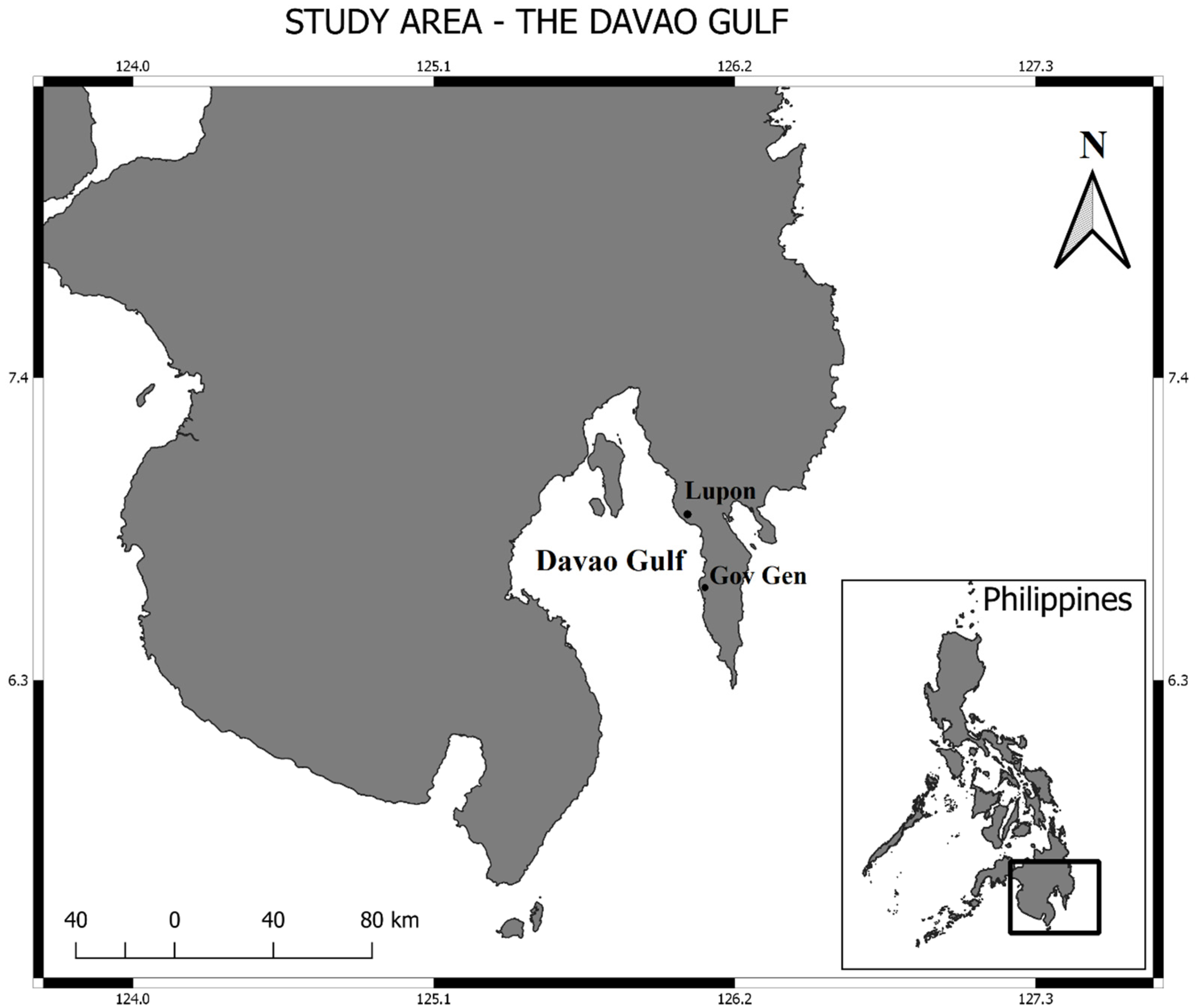
Estimates on the number of fishing boats in the Davao Gulf area show 13,930 municipal boats and 289 commercial fishing boats that fish in the gulf [31]. There is a total of 47,000 fishers in the Davao region most of them fish in the gulf, which has an area of 3087 km2. Any fishing boat that weighs greater than three gross tons (>3 GT) and operates for commercial purposes is considered a commercial fishing vessel. Examples of commercial fishing boats operating in the Davao Gulf include ringnets and bagnets, which weigh more than 3 GT and use encircling nets. A ringnet boat usually operates as a fleet having a motherboat, service boat, and light boats to catch a school of fish near a fish aggregating device (FAD), bring the catch to the shore, and use light for aggregating fish schools underneath FADs [32]. Ringnets are smaller than purse seines, usually composed of wood, and do not use power blocks to haul the fish; they will usually haul the fish using their crews. Large handliners are not usually allowed in the Davao Gulf, they operate outside the Davao Gulf and also make use of a mother boat and smaller handline boats called pakuras that are carried on its sides. It weighs more than 3 GT and fishes near the east coast of Davao Oriental, Surigao del Sur, and the Sulu-Celebes Sea, anchoring and fishing where fish aggregating devices (fads; payao) can be found to catch adult yellowfin, skipjack, and bigeye tunas. In contrast, small-scale fishing boats are classified in the Philippines as municipal fishing vessels characterized by less than three gross tons (<3 GT) used mainly for subsistence fishing. These municipal fishing boats are only allowed to operate within the 1–15 km range, while commercial fishing boats need to go beyond 15 km to operate. Moreover, the small-scale fishers were the only fishing sector allowed to fish during the closed fishing season in the Davao Gulf. This study only tracked small-scale fishing boats, using GPS trackers in combination with interviews. We did not track commercial fishers, mainly due to the hesitation of the boat owners to participate in the study. The selected study sites were Governor Generoso and Lupon, which were chosen due to the sizable presence of commercial and small-scale fishers in the two areas (Figure 1).
Governor Generoso has the largest number of active ringnet boats operating in the Davao Gulf with 38 ringnet boats and hosts four fishing companies, with 2341 registered fishers. In contrast, Lupon has a sizable number of active municipal fishers, with 1504 registered. In both areas, the small-scale fishers own their boats and use hooks and lines for fishing. Hook and line fishers use single lines, but they also use multiple hooks and lines, carrying these gears together when they catch fish. There are only a few ringnet boats compared to municipal or small-scale pumpboats because these boats require substantial capital to build the boat, equip it with fishing gear, and invest in fish aggregating devices or payao. An initial study on fisheries and catch monitoring has already provided an active collaboration between participant fishers and the authors, which facilitated the acceptance of the GPS tracking study among them. These small-scale fishers have been part of the pool of respondents in earlier interviews conducted in fisheries surveys in Davao Gulf [30].
Under the fisheries law of the Philippines, small-scale fishers are not obligated to carry GPS trackers or satellite transponders. Only commercial fishing boats operating as medium-scale commercial fishing boats (between 20 and 150 GT) and large-scale commercial fishing boats (>150 GT) are required by the law. During the study, the initial number of GPS trackers deployed was 30 (February 2020). GPS trackers from Reachfar RF-V20 multi-functional personal GPS tracker with a power bank by Shenzhen Reachfar Technology Company Limited were used. These trackers work for GSM networks with bands of 850/900/1800/1900 MHz, which send signals every 10 min on the location of the tracker. This was reduced to 16, mainly due to technical problems and malfunctions of the trackers, and by the end of the study in August, there were only 13 left that were functioning and giving useful coordinates to be analyzed. (Most of the technical problems and malfunctions came from trackers that were inadvertently submerged or splashed with seawater so that afterwards they did not function anymore as reported by our fisher cooperators). The GPS trackers automatically send data to satellites with the movement and track of the fishing boats and then send back the coordinates position to a database that is stored on an internet cloud for easy access and downloading.
2.2. Interview Survey
The boat tracking information was also supplemented with interviews of fisher participants from Governor Generoso and Lupon (N = 35). The interview questions referred to their demographic information (age, fishing experience), fishing operation (number of hours fishing, boat engine power, boat movement speed), catch characteristics, and common fishing areas. Moreover, additional data based on mapping interviews of fishers were also separately conducted, and all identified sites by the fishers as their fishing grounds were plotted and summarized on a map (N = 167).
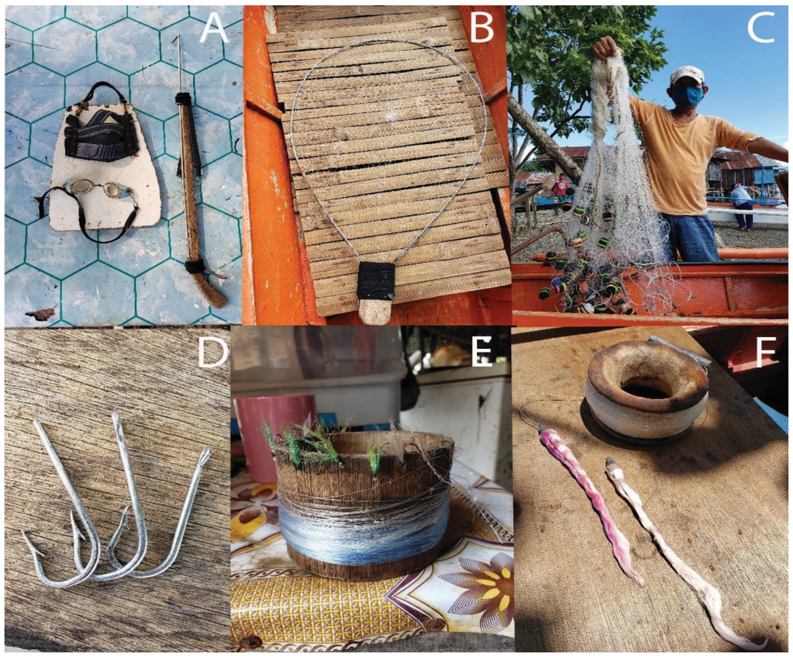
In addition, the fishers also still use the traditional fishing gears, such as scoopnets and spearguns, that are used to catch large-bodied reef fishes including groupers, snappers, and parrotfishes. While hooks and lines are usually used to catch yellowfin tuna, skipjack tuna, and frigate or bullet tuna (see Figure 2). Some fishing gears, however, have evolved into species-specific fishing gears, such as gillnets for catching finfish. Other gears found were bottom-set gillnets designed to catch crabs and shrimps, locally known as panglambay and pamasayan, while drift or surface gillnets, such as pambolinao or panamban, were intended to catch anchovies and sardines.
2.3. Supplementary Catch Data
Additional supplementary catch data downloaded from the Philippine Statistics Authority website (https://openstat.psa.gov.ph/; accessed on 17 January 2021) were used to compare the catches of the small-scale (municipal fishers) and commercial fisheries before and after the implementation of the closed fishing season in 2014. The data were a record of the quarterly catch of fishers used to check for differences before and after the implementation of the closed fishing season. Catch logbook monitoring data for Lupon and Governor Generoso were also analyzed for participant fishers (N = 20) from January 2020 to September 2020.
2.4. Data Analysis
All quantitative interview data from the fishers were recorded, averaged, and percentages were taken for the age, years of fishing, the number of hours fishing, boat power (hp), catch composition, average catch (kg), and boat speed (km/h). Fishing grounds were identified, processed, and analyzed using raw data downloaded from the GPS website, which consisted of Excel spreadsheets containing the positions (latitude and longitude), speed, direction, date, and time, with each tab divided by day. The data from the PSA (Philippine Statistics Authority), which includes quarterly catch data of various top commercial and small-scale fish catches, were first checked for their normality and then log10 transformed when it did not follow a normal distribution. Afterward, a test for equal variance was done on the data before using ANOVA for comparison of the catches. The same procedure was also done for the data coming from the catch logbooks. These data included the catch per trip, the date of the trip, and the price of the catch. Since there were few complete entries, data were pooled for the analysis to compare the top five species and the area or fishing ground in terms of their catch. A one-way ANOVA and t-test were used for the comparison of the before and after implementation of the closed fishing season and a comparison of the small-scale fish and commercial catches. A two-way ANOVA was used for the species and area analyses of the catch data from the participatory catch logbook monitoring. The software Minitab 17 was used for the data analyses (State College, PA, USA: Minitab, Inc.).
2.5. Identifying the Fishing Grounds and Fishing Effort
All GPS data were georeferenced using Quantum Geographic Information System (QGIS v.3.10.1, www.qgis.org; accessed on 1 April 2020). Each fishing trip was uploaded in QGIS as a shapefile in order to observe the fishers’ behavior. The positions on the land were excluded (usually, this happened when the GPS device was not turned off after the boat reached the coast). One of the standard practices to estimate the fishing effort allocation is based on a boat speed threshold, which identifies gear-dependent speed classes [33]. Thus, to identify the fishing grounds in Davao Gulf, only the speed class that indicates that the fishers were fishing was used in the evaluation. A histogram was built using all speeds recorded, and the speed classes associated with the fishing gears were observed [34]. This resulted in all the coordinates within this speed class being assumed as undertaking a fishing activity. Moreover, in the QGIS environment, a grid layer covering the entire study area was created using the tool “Create Grid Layer”. Each hexagon in this grid area was given a pre-set area equivalent to 3.2 km2 [35], and the number of GPS readings inside each hexagon was counted [36] using the Analysis Tool “Count Points in Polygon”. Note that only the positions within the speed class associated with the fishing gear used in the study area were counted in the analyses; the GPS positions related to travel to the fishing area were not included to make the visual representation of the fishing grounds more straightforward. This procedure created a new grid layer containing the information about the fishing grounds and the fishing effort allocated among them. In the end, the resolution of the fishing grounds was reduced to protect local knowledge regarding the exact location of the fishing grounds. Complementary to this spatial analysis, the number of fishers using each area in the Davao Gulf was estimated by determining the area used by each small-scale fisher and by overlapping these areas to evaluate which ones are more intensively used by several fishers. The minimum convex polygon was used to determine the maximum range that each fisherman fishes. Thus, using the same selected positions (within the fishing gears’ speed class), a polygon was drawn for each fisher using the geoprocessing tool “Convex Hull” to estimate the boundaries of their fishing grounds. The shapefiles of these polygons were projected on the map, and transparency was reduced (20%) to show the overlapping areas, estimating the areas used by more than one fisher.
2.6. Commercial Fishing Seasons Comparisons
To evaluate if the small-scale fishers changed their behavior when the commercial fishing season was closed, we analyzed GPS data from the time before the closure was implemented (20 February–31 May) and during the closure (1 June–31 August). Only five fishers have provided enough data during the open and closed fishing seasons to carry out this analysis. Using statistical software (IBM SPSS Statistics for Windows, Version 26.0. Armonk, NY, USA: IBM Corp.), we tested two hypotheses to evaluate if a possible reduction of the available space for fishing is reflected in two parameters (distance from the port and the speed classes). Seeing that the commercial vessels must fish farther than 15 km from the coast when the commercial fishing season is open, we aimed to understand if the small-scale fishers go to more distant fishing grounds when the commercial boats are not allowed to fish. Also, we hypothesized that during the closed fishing season, the small-scale fishers try to visit a higher number of fishing grounds, which is reflected in the distribution of the speed classes. Therefore, we tested these two hypotheses:
Hypothesis 1.
The fishers forage farther from the home port when the commercial vessels are prohibited.
Hypothesis 2.
The small-scale fishing boats’ distribution of speed classes changes when the commercial fishing season is closed.
First, the distance from each GPS recording to the port of origin was calculated in QGIS using the tool “Distances Matrix” to measure the distance in meters between the two layers. The recently created layer with the distances was extracted as an Excel file, and only the lines within the speed class associated with fishing activity were selected. The non-parametric test Kruskal-Wallis was used to evaluate if the distance from the port to fishing grounds varies significantly between fishers. Hypothesis one was tested by selecting the fishers who had fishing trips recorded during either the open or closed commercial fishing season, selecting only the speed class associated with fishing, and comparing the variance of the distance they fished using the Kruskal–Wallis test. On the other hand, hypothesis two was tested by comparing the variation in speed depending on the commercial fishing season status (open or closed) using the Mann-Whitney U test. In this last analysis, we included all GPS readings from these five fishers.
3. Results
3.1. Description of the Fishers and the Fisheries
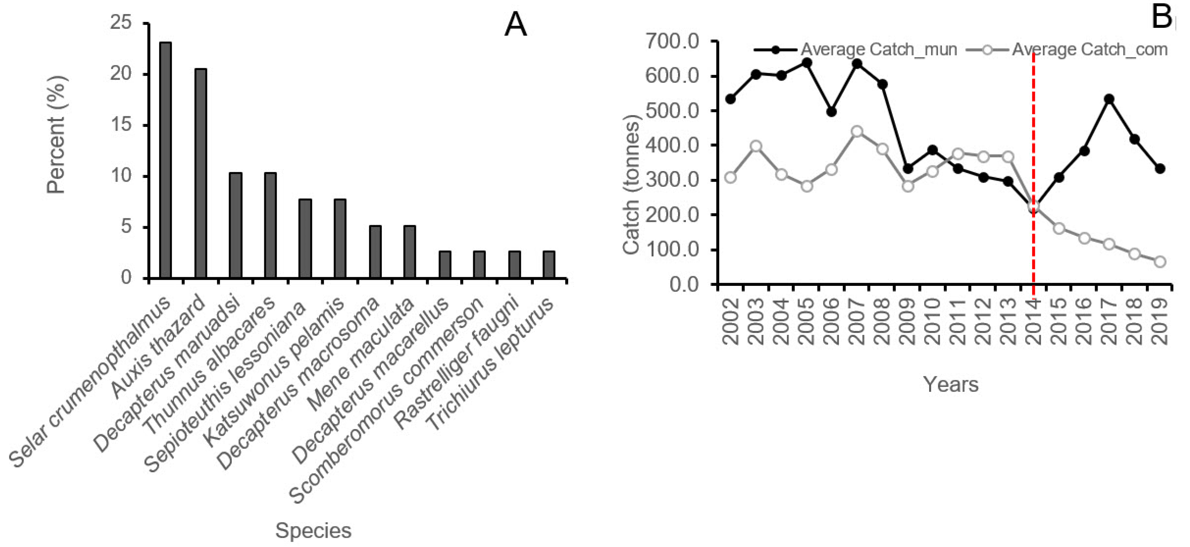
The age of participant fishers ranged from 35 to 64 years old, with an average age of 45 years old and with a fishing experience of 27 years; their cumulative fishing experience totaled to 328 years. Each fishing trip from port departure to arrival lasted for 18 h. Their boat engines ranged from 5 to 12 HP, with an average speed of 5.28 km.h−1. These fishers catch 7 kg of fish per fishing trip, using a hook and line. Their primary catch was dominated by big-eyed scad (Selar crumenophthalmus), 23%, frigate tuna (Auxis thazard), 21%, roundscad (Decapterus maruadsi), 10%, yellowfin tuna (Thunnus albacares), 10%, skipjack tuna (Katsuwonus pelamis), 8%, and common reef squid (Sepioteuthis lessoniana), 8% (Figure 3A). The catch trends of the municipal and commercial fishers are shown in Figure 3B, where their catch data were analyzed comparing before the implementation of the 2014 closed fishing season (data used 2002–2013) and after the implementation in 2014 (data used 2014–2019).
The analyses of the catch data before the period of the closed fishing season in 2014 showed highly significant differences [F(1, 670) 45.74, p < 0.001], with the small-scale fishers having an average annual catch of 357 t compared to 217 t for the commercial fishers; this difference in catch further widened after the implementation of the closure in 2014, with the commercial fisheries catch dropping to an average of just 80 t since 2014 while the small-scale fisheries catch also decreased to an average of 278 t [F(1, 334) 123.41, p < 0.001].
The t-test between catches of small-scale and commercial fisheries (using the catch data from 2002–2019) showed that the catch of small-scale fishers (329 t) was twice as high compared to the catch of commercial fishers (156 t) (t (1006) = −11.43, p < 0.001). At the same time, a quarterly analysis of the catch comparison did not yield any significant differences in the catch of the small-scale and commercial fishers [F(3, 500) 1.19, p = 0.314]. For the catch logbook data, significant differences were shown for the catch of the top five species with more than 30 entries compared [F(4, 298) 13.15, p < 0.001], but not in terms of the location or site [F(1, 298) 1.16, p = 0.282]. This means that the length of time of participation of fishers matters when using the catch logbook, e.g., nine months for those enrolled fishers in Lupon and Governor Generoso where data was compared. In addition, the number of participants using the catch logbook may not have been enough due to fewer data entries retrieved from the fishers at the study sites. However, it was shown that in terms of catch composition in the pooled data, the following catch species were frequently recorded and counted: skipjack tuna was highest (8 kg·trip−1), followed by the common reef squid (4 kg·trip−1), then big-eyed scad (2.5 kg·trip−1), frigate tuna (2.2 kg·trip−1), and roundscad (1.8 kg·trip−1).
3.2. Fishing Grounds and Effort Allocation
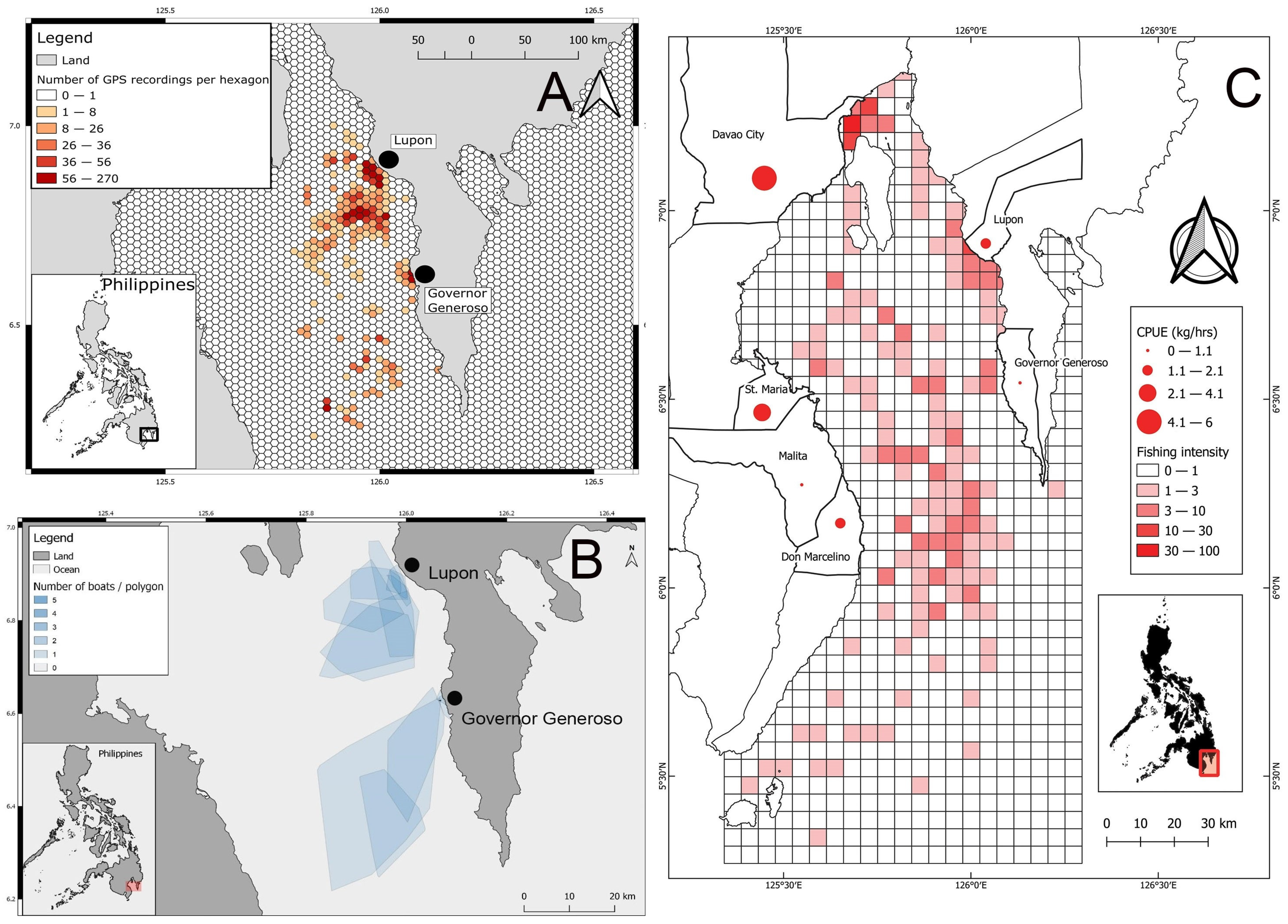
There were a total of 51 fishing boat tracks for Governor Generoso fishers and 213 boat tracks for Lupon fishers during the period of boat tracking. Most of the fishing trips were day or night trips, with fishers usually visiting shallow (<100 m) or deeper fishing areas (<1800 m). Line fishing was usually used for small-pelagics but could also be used for catching tuna. The speed recorded by the GPS devices was grouped into speed classes averaging 5.28 km/h with a standard deviation of 7.13 km/h (N = 8861), and by far, the most frequent speed class was between 0 and 1 km/h with more than N = 4000 GPS readings within this speed class. During the data analysis, we associated the frequent boat stops and waiting habit of the fishers to hook and line because, during the interview, the fishers have mentioned that they would depart from the port carrying baits with them or fish as a bait and then begin fishing once they reach their fishing grounds. Thus, we associated the speed class between 0 and 1 km/h with this fishing gear. Hence, when a GPS position had a speed that was within this speed class, we assumed that a fishing activity was taking place and used that information to identify the fishing grounds (Figure 4A,B).
Usually, the fishers leave the port and travel at a faster speed with a straighter trajectory to their fishing grounds. Once they reach their destinations, they slow down and stay there to fish. These fishing sites, where they stop and stay for a while, recorded speeds lower than 1 km/h and were identified on the map (Figure 4A), and the respective time spent in each hexagonal area was represented by different colors. As can be observed in Figure 4A, hexagons with more intense colors represent fishers who spent more time in that area. In both ports, they have an area that was intensely fished near the port and some areas with varying degrees of effort that spread further away from the port. This high frequency of GPS recordings indicates a higher degree of fishing effort in the area, which can be caused by a few fishers who spend a long time in the area or by many fishers who also use the area for fishing.
To investigate the number of fishers visiting each area, the minimum convex polygon analysis can reveal where the fishers may overlap with each other for their fishing grounds (Figure 4B). Most fishers from Lupon and Governor Generoso showed a tendency to fish towards the southwest direction from their respective home ports. In addition, some fishers have effort distributed just a few kilometers from their homeport (<10 km from Lupon and roughly 22 km from Governor Generoso), while other fishers concentrated only in a smaller area closer to the port. Moreover, the map also showed that intra-zonal visits of fishers from the same port occurred in their various fishing areas, but there were no recorded instances of interzonal visits from the two ports of origin throughout the duration of tracking, which seems to show that they strictly adhere to their own designated fishing areas (Figure 4B). In both ports of Lupon and Governor Generoso, several fishers were observed fishing in either the offshore areas or in areas closer to the shore, which was confirmed by the consolidated map based on interviews of fishers in the Davao Gulf, with fishing intensity being high nearshore in Lupon and Governor Generoso as well as in Bunawan and Lasang in the Davao City and towards the middle portion of the gulf (Figure 4C).
3.3. Comparison between Open and Closed Fishing Seasons and between Sites
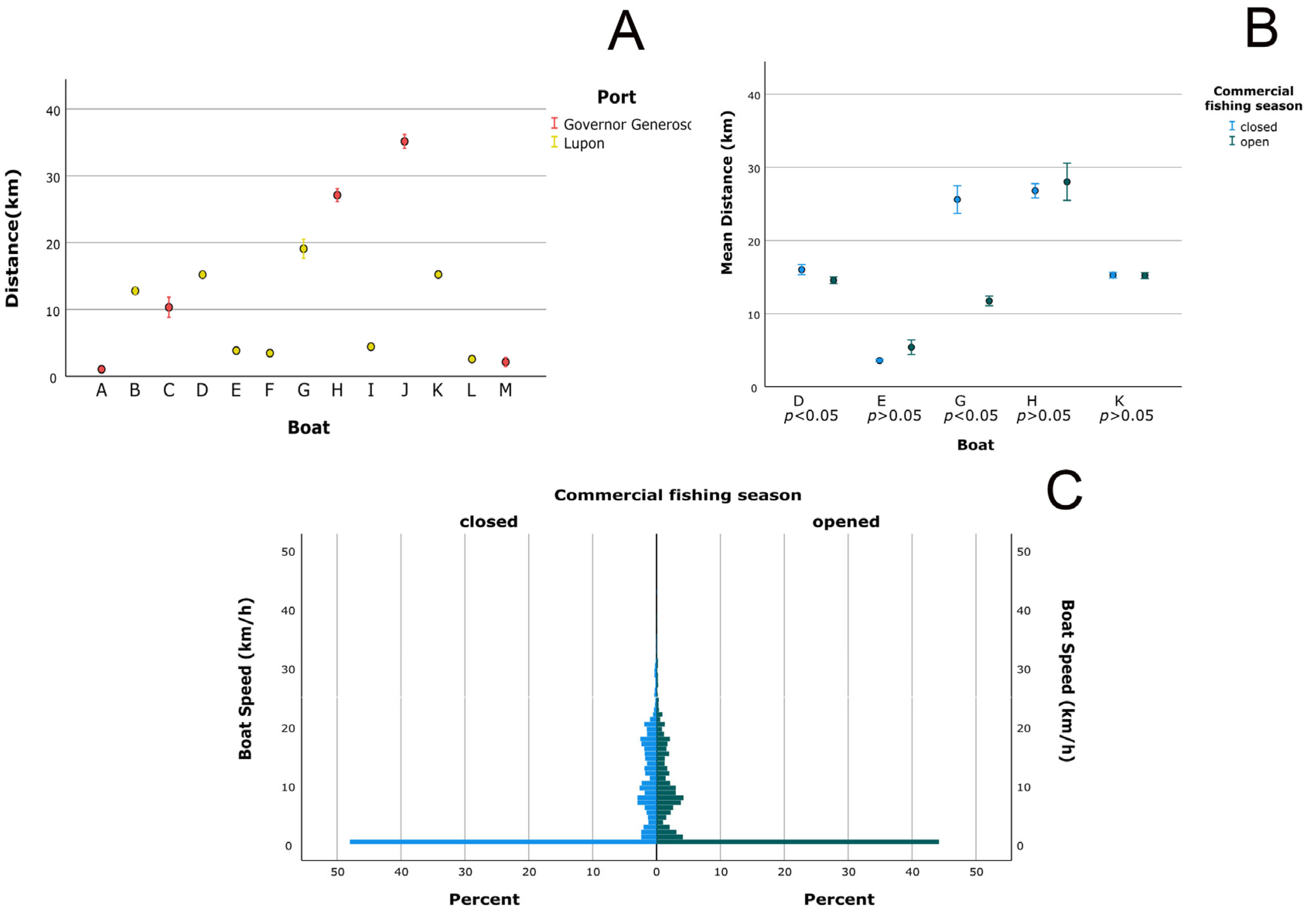
The result of comparing the distance traveled between fishers using the Kruskal–Wallis test on distance traveled from port to fishing ground varied significantly between each fisher (p < 0.05). For instance, some fishers did not travel farther than 10 km from the port, such as fishers A, E, F, I, L, and M, while other fishers would fish between 10 and 20 km from their port of origin, such as fishers B, C, D, G, and K (see Figure 5A). Only a few other fishers would usually fish farther than 20 km from the port using hook and line; they were fishers H and J, approximately 27 km and 35 km, respectively. Even though the variation in the distance fished was significantly high among all fishers, there were significant similarities among the small groups of fishers. Those fishers operating from Lupon (eight fishers) were fishing less than 20 km most of the time, but so were the three fishers from Governor Generoso. This could indicate that the two fishers who were fishing much farther away than the rest of the group could have been avoiding heavily fished areas near the shore (see Figure 5).
In addition, the comparison between the speed and distance traveled during the open and closed fishing seasons by the selected fishers with complete tracks were compared to identify changes in the behavior of the small-scale fishers (Figure 5B). The distance traveled from the home port was tested on five fishers who had enough data during both the open and the closed fishing seasons. Two of them were observed fishing significantly farther away from the port during the closed fishing season when compared to the open season. The other three fishers (E, H, and K) did not exhibit significant changes regarding the distance they fished during the open and closed fishing seasons. In summary, for Hypothesis 1 on whether the fishers went farther away from their home port during the closed fishing season, fishers D and G have shown that they fished in more distant fishing grounds.
On the other hand, the speed at which the fishers moved to their fishing grounds did not vary significantly (p > 0.05), even when there was an implementation of the closed fishing season (June, July, and August). The five small-scale fishing boats tracked in this analysis did not show a significant change in their speed between seasons. Although, we observed a slight increase in the relative frequency of the speed class associated with the fishing activity 0–1 km·h−1 (Figure 5C). The other speed classes follow roughly the same pattern in both seasons, with similar peaks in the same classes.
4. Discussion
4.1. Boat Tracking and Sustainable Fishing
Studies on the assessment of fishing effort using GPS trackers provided to fishers are rare in most tropical areas. This is because only commercial fishing boats are required to carry satellite transponders, with automatic identification systems (AIS) and vessel monitoring system (VMS) as standard practices [37]. These are used to monitor the movement and fishing activities of commercial fishing vessels and are known to provide effective management oversight [38]. The use of GPS for time-area closures has been applied for a long time in temperate fisheries and is being used to provide more accurate data of positions and tracks and give a more precise effort assessment in the fisheries management [6,20,38]. It seems that the application of GPS in the small-scale fisheries could provide a motivation for fishers to be more conservative in their attitude toward fishing compared to considering their fishing grounds as an open access as they become more conscious or aware of different area restrictions imposed on their fishing activities [6,18]. In the Davao Gulf, the use of GPS trackers could enhance the implementation of a closed fishing season among fishers to detect the magnitude or intensity of their presence in an area during the closed or open season. The gulf is for exclusive use by small-scale fishers but also for tourism and commercial logistics or transportation. However, there is no international commercial fishing allowed in the area.
In addition, given that the sheer number of small-scale fishers in the country can have a collective and negative impact on the marine ecosystem due to unsustainable fishing practices, pilot sites can be implemented where small-scale fishers are incentivized by the government and NGOs (non-government organizations) by connecting them directly to their markets when their catches are traceable using digital technology [39,40].
Sustainable fishing, which includes solutions such as catch traceability, area restrictions, and time closures, is sometimes presented as an “either-or” choice between food security and the conservation of fish stocks. Fishers gain more when their catches are traceable and are facilitated to be directly connected to their markets [41,42]. Without gear-based restrictions, sustainable eco-tourism, time area closures, and market-based solutions, the open-access nature of the fisheries can lead to further deterioration of the food security and a possible loss of slow-growing, large-bodied fishes due to overfishing [11,43,44,45]. The removal of these fishes, which are the top predators in the ecosystem, can lead to broad phase shifts, resulting in algal growth and an increasing number of invertebrates [46,47,48]. As previously shown in the frequently caught species in the study areas, apart from fish species that included Selar crumenophthalmus, Auxis thazard, Decapterus maruadsi, D. macarellus, Katsuwonus pelamis, and Thunnus albacares, invertebrates such as common reef squid and the Philippine octopus were also abundant in the catches. Although there were no studies relating the abundance of these invertebrates to the decreased abundance of pelagic fishes, it could be possible that their recent increasing abundance might indicate the over-harvesting of large finfish species that usually prey on them and control their abundance in the marine ecosystem.
4.2. Comparison between Small-Scale and Commercial Fisheries
The comparison of the fish catch between the small-scale and commercial fisheries has shown that ever since the implementation of the closed fishing season, there was a downward trend in the catch of commercial fishers, while there was an increase in the catch of small-scale fishers [2]. While this could be laudable, it has been shown that protected sites need multiple years of protection for the effects of conservation to become evident [16,49]. There is a needed period of adjustment for both the commercial and small-scale fishers, including the coastal communities, with the implementation of new management regimes [10]. Managing the excess boat and fishing gear capacities may take some time after the imposition of the closed fishing season, but a follow-up moratorium in terms of the number of boats and fishing gears to be licensed in the fishing grounds should be actively sought [30,50]. Together with a more effective campaign for a fishing and non-fishing-based alternative livelihood program, e.g., eco-tourism, this could help some, if not many, of the fishers eventually leave the fisheries, moving on to fish processing activities such as drying, salting fish, fish sauce processing, seaweed farming, vegetable gardening, and livestock raising [50].
4.3. Effort Allocation of Fishers
There were differences in terms of the effort allocation of the fishers from the two homeports, especially in terms of the distance traveled and as well as in the depth of fishing grounds exploited. This probably has some relationship with regards to their target species [32] and their boat power. Based on our previous interviews, the age of fishers and their boat power generally show a pattern of how far they can go fishing and the type of fishing grounds that they will exploit. Larger engine sizes will enable the fishers to navigate against larger waves and stronger winds.
We have also identified that the fishers usually visit the same fishing grounds that they visited the previous day. This was similar to the case of FAD fishers interviewed before, who also behaved in the same way by previously visiting FADs they had previously exploited [8]. Some significant changes to their fishing route were also observed, but they were less frequent, and this type of behavior was assumed to be due to their years of fishing, taking into account some factors such as the estimated arrival time in their fishing grounds and the amount of fuel needed for their overall travel [51]. The fishers usually exploit the fishing grounds, which have proven to provide enough fish catches. Occasionally, they try to explore new fishing grounds to fish. However, as shown by the intensity of effort allocation in the two study sites, small-scale fishers seem to have a preference for nearby areas [51], which quickly become intensely fished [52]. It is also possible that because the boat power and boat designs are usually small; the boats cannot go far from the shoreline. This might have a consequence on the primary goal of conserving fish stocks. Understanding why these fishers usually exploit these areas should provide a better reason to protect or limit the fishing intensity occurring in these areas. Although the individual catch contribution of small-scale fishers was much smaller compared to commercial fishers, the constant fishing pressure can also cause fish stock depletion and allowing them to fish beyond what is necessary could result in a highly exploited fish stock in the area [53,54]. Most of the catch of small-scale fishers are usually sold to their neighbors and the public market. During the closed season, the prices of fish in the public market are usually higher than other months due to lower supply [55].
Since the overlap between small-scale and commercial fishing grounds has been observed in some areas [56], we expected to see a possible competition for marine resources in the Davao Gulf reflected in the small-scale fishers’ behavior. However, the differences in the behavior of small-scale fishers observed between the closed and open fishing seasons were not significant regarding the differences in speed classes and the distance they go fishing. It might be caused by the fact that small-scale fishers did not change their behavior when commercial fishers were not allowed to fish. It could also be possible that the small number of fishers who provided enough data in both seasons (N = 5) was not sufficiently powerful to identify changes in their behavior. Although there were two fishers (D and G) who significantly changed the distance they went fishing during the closed fishing season by fishing in more distant fishing areas relative to their homeport, this might indicate possible exploitation of available fishing grounds more distant from the nearshore [21]. The closed fishing season in the Davao Gulf was rarely a problem for the small-scale fishers, as they remained free to fish in whatever season, and they can target their preferred fish.
Furthermore, participatory GPS tracking that includes fishers’ anecdotal information can lead to accurate estimates of the distribution of their fishing effort. Although it is advocated that using speed alone can represent the fishing grounds with inaccuracy [57], for small-scale hook and line fishers, their effort allocation was illustrated well when this was compared with the tracks obtained containing GPS positions that were connected chronologically. Remarkably, the small-scale fishers in the Davao Gulf tend to move in the southwest direction of their port of origin, without any overlap being observed between fishers from the two ports studied. This indicates a possible division of resources (i.e., fishing areas) between ports and suggests a degree of turfing behavior between fishers, as can also be observed in commercial fishing. Although the speed related to the fishing activity was identified between 0 and 1 km/h for most of the fishing gears used in the Davao Gulf, it was also noticed that the histogram of speeds has other peaks in different speed classes (e.g., 2–3 km·h−1 and 7–10 km·h−1), which might indicate the use of other fishing gears to a smaller extent. Hence, it is suggested that some fishing gear might have been used with those boat movements, and the use of other fishing gear might require the boat to be almost stationary. It is possible that the other peaks in the different speed classes also represent the traveling speed to the fishing grounds, which were identified to follow a straighter course. Given that the number of fishers tracked in this study was relatively small, more studies considering other variables, such as turning angles and more fishers tracked, are necessary for a more complete description and understanding of the fishing grounds and fishing effort allocation in southern Philippines.
5. Conclusions
This study generated new insights regarding small-scale fisheries in the Davao Gulf by providing primary fisheries data on the movement patterns of boats, their speed, frequency, and intensity of fishing, and by mapping their spatial behavior. It presents the essential information required for more complex and reliable estimations of catch, effort, and CPUE [58]. In this study, the effort allocation was different in the two study areas (Lupon and Governor Generoso) due to differences in age, fishing experience, engine size, and spatial behavior among fishers. We also described the main fishing gears used by the small-scale fishers, observed patterns of the fishing trips, and evaluated the seasonality. Moreover, this study demonstrated that a low-cost GPS tracker can be used by fishers in their daily fishing activities, which could instill a compliance behavior among fishers and enable more traceable, well-managed local fisheries. If this study were applied to a wider area, the success of its implementation could lead to benefits related to solving fisheries management issues such as open-access fisheries. Moreover, the data generated from the monitoring of the impacts of fishing on the target stocks can show distribution patterns and changes in fishing activities due to the impact of regulations in such closure areas [59,60]. Thus, this study supports the use of GPS tracking to evaluate the small-scale fishing effort and enhance the engagement and participation of fishers in fisheries management. In some areas or other fishing grounds where the fisheries management may not prosper, there could be a need for other types of intervention, e.g., livelihood provisions, payment for seasonal work, together with seasonal area closures to be implemented [61].
Author Contributions
Conceptualization, E.D.M., A.C.d.C.-N. and R.P.B.; methodology, E.D.M. and A.C.d.C.-N.; software, A.C.d.C.-N. and C.D.T.; validation, C.D.T. and R.P.B.; formal analysis, E.D.M., A.C.d.C.-N. and R.P.B.; investigation, E.D.M., A.C.d.C.-N. and C.D.T.; resources, E.D.M.; data curation, E.D.M. and A.C.d.C.-N.; writing—original draft preparation, C.D.T.; writing—review and editing, E.D.M., A.C.d.C.-N. and R.P.B.; visualization, E.D.M. and A.C.d.C.-N.; supervision, R.P.B.; project administration, E.D.M.; funding acquisition, E.D.M. All authors have read and agreed to the published version of the manuscript.
Funding
This research was made possible through the funding of PCAARRD (Philippine Council for Agriculture, Aquatic and Natural Resources Research and Development) for the project: Fisheries catch assessment using GPS trackers and effort survey of municipal and commercial fishers in Mindanao and SEARCA (Southeast Asian Regional Center for Graduate Study and Research in Agriculture) for the project: Biological and socioeconomic impacts of the closure fishing ban in Davao Gulf and the Zamboanga Peninsula: relevance of effort distribution and role of governance. Part of the data analysis was performed co-funded by the Erasmus+ Programme of the European Union.
Informed Consent Statement
Informed consent was obtained from all subjects involved in the study for participation in the GPS tracking as well as interviews.
Data Availability Statement
Data is available with consent from the authors.
Acknowledgments
We are grateful for the assistance provided by Ilah Dianne Morales, Charlen Mae G. Canales, and Arianne Kay Liguez during the field monitoring and interviews of this project. We are also thankful for the warm welcome of the fishing communities during the data validation and for making this study possible because of their cooperation in Governor Generoso and Lupon.
Conflicts of Interest
The authors declare no conflict of interest.
References
- Villanueva, J.A. Assessment of Commercially Important Small Pelagic Fishes in Davao Gulf CY 2004–2013. Philipp. J. Fish. 2018, 25, 163–182. [Google Scholar] [CrossRef]
- NEDA. Davao Regional Development Plan, 2017–2022; National Economic and Development Authority Regional Office XI: Davao City, Philippines, 2017; p. 402.
- McClanahan, T.; Allison, E.H.; Cinner, J.E. Managing fisheries for human and food security. Fish Fish. 2015, 16, 78–103. [Google Scholar] [CrossRef]
- Bell, J.D.; Albert, J.; Andréfouët, S.; Andrew, N.L.; Blanc, M.; Bright, P.; Brogan, D.; Campbell, B.; Govan, H.; Hampton, J.; et al. Optimising the use of nearshore fish aggregating devices for food security in the Pacific Islands. Mar. Policy 2015, 56, 98–105. [Google Scholar] [CrossRef]
- Muallil, R.N.; Mamauag, S.S.; Cabral, R.B.; Celeste-Dizon, E.O.; Aliño, P.M. Status, trends and challenges in the sustainability of small-scale fisheries in the Philippines: Insights from FISHDA (Fishing Industries’ Support in Handling Decisions Application) model. Mar. Policy 2014, 44, 212–221. [Google Scholar] [CrossRef]
- Daw, T.; Maina, J.; Cinner, J.; Robinson, J.; Wamukota, A. The Spatial Behaviour of Artisanal Fishers: Implications for Fisheries Management and Development (Fishers in Space); Western Indian Ocean Marine Science Association (WIOMSA): Zanzibar, Tanzania, 2011; p. 79. [Google Scholar]
- Stevenson, T.C.; Tissot, B.N.; Walsh, W.J. Socioeconomic consequences of fishing displacement from marine protected areas in Hawaii. Biol. Conserv. 2013, 160, 50–58. [Google Scholar] [CrossRef]
- Macusi, E.D.; Babaran, R.P.; van Zwieten, P.A.M. Strategies and tactics of tuna fishers in the payao (anchored FAD) fishery from general Santos city, Philippines. Mar. Policy 2015, 62, 63–73. [Google Scholar] [CrossRef]
- Pomeroy, R.; Douvere, F. The engagement of stakeholders in the marine spatial planning process. Mar. Policy 2008, 32, 816–822. [Google Scholar] [CrossRef]
- Pomeroy, R.; Parks, J.; Pollnac, R.; Campson, T.; Genio, E.; Marlessy, C.; Holle, E.; Pido, M.; Nissapa, A.; Boromthanarat, S.; et al. Fish wars: Conflict and collaboration in fisheries management in Southeast Asia. Mar. Policy 2007, 31, 645–656. [Google Scholar] [CrossRef]
- Cabral, R.; Cruz-Trinidad, A.; Geronimo, R.; Napitupulu, L.; Lokani, P.; Boso, D.; Casal, C.M.; Ahmad Fatan, N.; Aliño, P. Crisis sentinel indicators: Averting a potential meltdown in the Coral Triangle. Mar. Policy 2013, 39, 241–247. [Google Scholar] [CrossRef]
- Horigue, V.; Pressey, R.L.; Mills, M.; Brotánková, J.; Cabral, R.; Andréfouët, S. Benefits and Challenges of Scaling Up Expansion of Marine Protected Area Networks in the Verde Island Passage, Central Philippines. PLoS ONE 2015, 10, e0135789. [Google Scholar] [CrossRef]
- Muallil, R.N.; Geronimo, R.C.; Cleland, D.; Cabral, R.B.; Doctor, M.V.; Cruz-Trinidad, A.; Aliño, P.M. Willingness to exit the artisanal fishery as a response to scenarios of declining catch or increasing monetary incentives. Fish. Res. 2011, 111, 74–81. [Google Scholar] [CrossRef]
- Brillo, B.B.C.; Elazegui, D.D.; Cervantes, C.P.; Rola, A.C. Assessing the Formulation and Implementation of the Closed Fishing Season Policy for Sardines in Zamboanga Peninsula, Philippines. Philipp. J. Sci. 2016, 145, 395–404. [Google Scholar]
- Toribio, M.Z.; Arceo, H.O.; Aliño, P.M. Sharing the Costs and Benefits of Marine Protected Areas: Implications for Good Coastal Resource Governance. In Governing the Provision of Ecosystem Services, Studies in Ecological Economics; Muradian, R., Rival, L., Eds.; Springer Science and Business Media: Dordrecht, The Netherlands, 2013; Volume 4, pp. 149–169. [Google Scholar]
- Alcala, A.C.; Russ, G.R. No-take marine reserves and reef fisheries management in the Philippines: A new people power revolution. Ambio 2006, 35, 245–254. [Google Scholar] [CrossRef] [PubMed]
- Bagsit, F.; Frimpong, E.; Asch, R.G.; Monteclaro, H.M. Effect of a seasonal fishery closure on sardine and mackerel catch in the Visayan Sea, Philippines. Front. Mar. Sci. 2021, 8, 640772. [Google Scholar] [CrossRef]
- Fernandez, P.N.; Gaje, A.; Babaran, R.P. Comparison of Low-Cost Global Positioning System (GPS) Data Loggers for Their Potential Application in Fishing Vessel Monitoring System in the Philippines. Asian Fish. Sci. 2019, 32, 56–63. [Google Scholar] [CrossRef]
- Obura, D.O.; Aeby, G.; Amornthammarong, N.; Appeltans, W.; Bax, N.; Bishop, J.; Brainard, R.E.; Chan, S.; Fletcher, P.; Gordon, T.A.C.; et al. Coral Reef Monitoring, Reef Assessment Technologies, and Ecosystem-Based Management. Front. Mar. Sci. 2019, 6, 580. [Google Scholar] [CrossRef] [Green Version]
- Rijnsdorp, A.D.; Poos, J.J.; Quirijns, F.J. Spatial dimension and exploitation dynamics of local fishing grounds by fishers targeting several flatfish species. Can. J. Fish. Aquat. Sci. 2011, 68, 1064–1076. [Google Scholar] [CrossRef]
- Daw, T.M. Spatial distribution of effort by artisanal fishers: Exploring economic factors affecting the lobster fisheries of the Corn Islands, Nicaragua. Fish. Res. 2008, 90, 17–25. [Google Scholar] [CrossRef] [Green Version]
- Weeks, R.; Aliño, P.M.; Atkinson, S.; Beldia, P.; Binson, A.; Campos, W.L.; Djohani, R.; Green, A.L.; Hamilton, R.; Horigue, V.; et al. Developing Marine Protected Area Networks in the Coral Triangle: Good Practices for Expanding the Coral Triangle Marine Protected Area System. Coast. Manag. 2014, 42, 183–205. [Google Scholar] [CrossRef] [Green Version]
- Brillo, B.B.C.; Jalotjot, H.C.; Cervantes, C.C.; Rola, A.C. Impact on income and livelihood of fisheries workers: Closed fishing season policy for sardines in Zamboanga Peninsula, Philippines. J. Coast. Conserv. 2019, 23, 1057–1067. [Google Scholar] [CrossRef]
- Cohen, P.; Cinner, J.; Foale, S. Fishing dynamics associated with periodically-harvested marine closures. Glob. Environ. Chang. 2013, 23, 1702–1713. [Google Scholar] [CrossRef]
- Duncombe, R. Mobile Phones for Agricultural and Rural Development: A Literature Review and Suggestions for Future Research. Eur. J. Dev. Res. 2016, 28, 213–235. [Google Scholar] [CrossRef]
- Donner, J. The use of mobile phones by micro-entrepreneurs in Kigali, Rwanda: Changes to social and business networks. Inf. Technol. Int. Dev. 2007, 3, 3–19. [Google Scholar] [CrossRef]
- Merrifield, M.S.; McClintock, W.; Burt, C.; Fox, E.; Serpa, P.; Steinback, C.; Gleason, M. MarineMap: A web-based platform for collaborative marine protected area planning. Ocean. Coast. Manag. 2013, 74, 67–76. [Google Scholar] [CrossRef]
- Hoang, H.G. Determinants of the adoption of mobile phones for fruit marketing by Vietnamese farmers. World Dev. Perspect. 2020, 17, 100178. [Google Scholar] [CrossRef]
- Rola, A.C.; Narvaez, T.A.; Naguit, M.R.A.; Elazegui, D.D.; Brillo, B.B.C.; Paunlagui, M.M.; Jalotjot, H.C.; Cervantes, C.P. Impact of the closed fishing season policy for sardines in Zamboanga Peninsula, Philippines. Mar. Policy 2018, 87, 40–50. [Google Scholar] [CrossRef]
- Macusi, E.D.; Liguez, A.K.O.; Macusi, E.S.; Digal, L.N. Factors influencing catch and support for the implementation of the closed fishing season in Davao Gulf, Philippines. Mar. Policy 2021, 130, 104578. [Google Scholar] [CrossRef]
- Armada, N.B. Fishery resources assessment of Davao Gulf, Philippines. In Resource and Social Assessment of Davao Gulf, Philippines; University of the Philippines Visayas: Miagao, Iloilo, Philippines, 2002. [Google Scholar]
- Macusi, E.D. Fish Aggregating Devices and the Role of Socio-Economic Factors in Driving Spatial Effort Allocation of Fishers; SEARCA: Los Baños, Laguna, Philippines, 2016. [Google Scholar]
- Behivoke, F.; Etienne, M.-P.; Guitton, J.; Randriatsara, R.M.; Ranaivoson, E.; Léopold, M. Estimating fishing effort in small-scale fisheries using GPS tracking data and random forests. Ecol. Indic. 2021, 123, 107321. [Google Scholar] [CrossRef]
- Forero, G.N.; Miñarro, S.; Mildenberger, T.K.; Breckwoldt, A.; Sudirman; Reuter, H. Participatory boat tracking reveals spatial fishing patterns in an Indonesian artisanal fishery. Front. Mar. Sci. 2017, 4, 409. [Google Scholar] [CrossRef] [Green Version]
- Mills, C.M.; Townsend, S.E.; Jennings, S.; Eastwood, P.D.; Houghton, C.A. Estimating high resolution trawl fishing effort from satellite-based vessel monitoring system data. ICES J. Mar. Sci. 2007, 64, 248–255. [Google Scholar] [CrossRef] [Green Version]
- Murawski, S.A.; Wigley, S.E.; Fogarty, M.J.; Rago, P.J.; Mountain, D.G. Effort distribution and catch patterns adjacent to temperate MPAs. ICES J. Mar. Sci. 2005, 62, 1150–1167. [Google Scholar] [CrossRef]
- de Souza, E.N.; Boerder, K.; Matwin, S.; Worm, B. Improving Fishing Pattern Detection from Satellite AIS Using Data Mining and Machine Learning. PLoS ONE 2016, 11, e0158248. [Google Scholar] [CrossRef]
- Rijnsdorp, A.D.; Buys, A.M.; Storbeck, F.; Visser, E.G. Microscale distribution of beam trawl effort in the southern North Sea between 1993 and 1996 in relation to the trawling frequency of the sea bed and the impact on benthic organisms. ICES J. Mar. Sci. 1998, 55, 403–419. [Google Scholar] [CrossRef]
- Digal, L.N.; Placencia, S.G.P. Factors affecting the adoption of sustainable tuna fishing practices: The case of municipal fishers in Maasim, Sarangani Province, Region 12, Philippines. Mar. Policy 2017, 77, 30–36. [Google Scholar] [CrossRef]
- Tolentino-Zondervan, F.; Berentsen, P.; Bush, S.R.; Digal, L.; Oude Lansink, A. Fisher-Level Decision Making to Participate in Fisheries Improvement Projects (FIPs) for Yellowfin Tuna in the Philippines. PLoS ONE 2016, 11, e0163537. [Google Scholar] [CrossRef] [Green Version]
- Tabios, B. Tuna traceability, the Philippine national plan of action against IUU Fishing. In Proceedings of the 16th National Tuna Congress, General Santos City, Philippines, 4–5 September 2014. [Google Scholar]
- Jacquet, J.; Hocevar, J.; Lai, S.; Majluf, P.; Pelletier, N.; Pitcher, T.; Sala, E.; Sumaila, R.; Pauly, D. Conserving wild fish in a sea of market-based efforts. Oryx 2010, 44, 45–56. [Google Scholar] [CrossRef] [Green Version]
- Lavides, M.N.; Molina, E.P.V.; de la Rosa, G.E., Jr.; Mill, A.C.; Rushton, S.P.; Stead, S.M.; Polunin, N.V.C. Patterns of Coral-Reef Finfish Species Disappearances Inferred from Fishers’ Knowledge in Global Epicentre of Marine Shorefish Diversity. PLoS ONE 2016, 11, e0155752. [Google Scholar] [CrossRef] [PubMed] [Green Version]
- Pauly, D.; Christensen, V.; Dalsgaard, J.; Froese, R.; Torres, F. Fishing down marine food webs. Science 1998, 279, 860–863. [Google Scholar] [CrossRef]
- Cabral, R.B.; Aliño, P.M. Transition from common to private coasts: Consequences of privatization of the coastal commons. Ocean. Coast. Manag. 2011, 54, 66–74. [Google Scholar] [CrossRef]
- Hughes, T.P.; Bellwood, D.R.; Hoegh-Guldberg, O.; Moltschaniwskyj, N.; Steneck, R.S.; Rodrigues, M.J.; Ceccarelli, D.; Laurence McCook, L.; Pratchett, M.S.; Bette Willis, B. Phase Shifts, Herbivory, and the Resilience of Coral Reefs to Climate Change. Curr. Biol. 2007, 17, 360–365. [Google Scholar] [CrossRef] [Green Version]
- Brotz, L.; Cheung, W.W.L.; Kleisner, K.; Pakhomov, E.; Pauly, D. Increasing jellyfish populations: Trends in Large Marine Ecosystems. Hydrobiologia 2012, 690, 3–20. [Google Scholar] [CrossRef]
- Fogarty, M.J.; Gamble, R.; Perretti, C.T. Dynamic Complexity in Exploited Marine Ecosystems. Front. Ecol. Evol. 2016, 4, 68. [Google Scholar] [CrossRef] [Green Version]
- Yang, D.; Pomeroy, R. The impact of community-based fisheries management (CBFM) on equity and sustainability of small-scale coastal fisheries in the Philippines. Mar. Policy 2017, 86, 173–181. [Google Scholar] [CrossRef]
- Salayo, N.; Garces, L.; Pido, M.; Viswanathan, K.; Pomeroy, R.; Ahmed, M.; Siason, I.; Seng, K.; Masae, A. Managing excess capacity in small-scale fisheries: Perspectives from stakeholders in three Southeast Asian countries. Mar. Policy 2008, 32, 692–700. [Google Scholar] [CrossRef]
- Estrella, C.; Swartzman, G. The Peruvian artisanal fishery: Changes in patterns and distribution over time. Fish. Res. 2010, 101, 133–145. [Google Scholar] [CrossRef]
- Caddy, J.F.; Carocci, F. The spatial allocation of fishing intensity by port-based inshore fleets: A GIS application. ICES J. Mar. Sci. 1999, 56, 388–403. [Google Scholar] [CrossRef]
- Muallil, R.N.; Mamauag, S.S.; Cababaro, J.T.; Arceo, H.O.; Aliño, P.M. Catch trends in Philippine small-scale fisheries over the last five decades: The fishers’ perspectives. Mar. Policy 2014, 47, 110–117. [Google Scholar] [CrossRef]
- Lavides, M.N.; Polunin, N.V.C.; Stead, S.M.; Tabaranza, D.G.; Comeros, M.T.; Dongallo, J.R. Finfish disappearances around Bohol, Philippines inferred from traditional ecological knowledge. Environ. Conserv. 2010, 36, 235–244. [Google Scholar] [CrossRef] [Green Version]
- Macusi, E.D.; Morales ID, G.; Macusi, E.S.; Pancho, A.; Digal, L.N. Impact of closed fishing season on supply, catch, price and the fisheries market chain. Mar. Policy 2022, 138, 105008. [Google Scholar] [CrossRef]
- Horta, S.; Defeo, O. The spatial dynamics of the whitemouth croaker artisanal fishery in Uruguay and interdependencies with the industrial fleet. Fish. Res. 2012, 125–126, 121–128. [Google Scholar] [CrossRef]
- Bastardie, F.; Nielsen, J.R.; Andersen, B.S.; Eigaard, O.R. Effects of fishing effort allocation scenarios on energy efficiency and profitability An individual-based model applied to Danish fisheries. Fish. Res. 2010, 106, 501–516. [Google Scholar] [CrossRef]
- Stamatopoulos, C. Sample-Based Fishery Surveys: A Technical Handbook; Food and Agriculture Organization (FAO): Rome, Italy, 2002; p. 144. [Google Scholar]
- Hiddink, J.G.; Jennings, S.; Kaiser, M.J. Assessing and predicting the relative ecological impacts of disturbance on habitats with different sensitivities. J. Appl. Ecol. 2007, 44, 405–413. [Google Scholar] [CrossRef]
- Torres-Irineo, E.; Gaertner, D.; de Molina, A.D.; Ariz, J. Effects of time-area closure on tropical tuna purse-seine fleet dynamics through some fishery indicators. Aquat. Living Resour. 2011, 24, 337–350. [Google Scholar] [CrossRef]
- Macusi, E.D.; Sabino, L.L.; Macusi, E.S. Closed Season Policy Is Only Partly Practiced in Surigao del Sur, Philippines. World 2022, 3, 1067–1079. [Google Scholar] [CrossRef]
Figure 1.
Map of the study sites Lupon and Governor Generoso in Davao Gulf, Philippines.

Figure 2.
Samples of fishing gears used by small-scale fishers of Governor Generoso and Lupon; (A) speargun, (B) scoopnet, (C) gillnet, (D) samples of hooks, (E) multiple hook and line, and (F) species specific handline.
Figure 2.
Samples of fishing gears used by small-scale fishers of Governor Generoso and Lupon; (A) speargun, (B) scoopnet, (C) gillnet, (D) samples of hooks, (E) multiple hook and line, and (F) species specific handline.

Figure 3.
Fisheries catch characteristics of Davao Gulf, based on interview of fishers (N = 35) (A); catch trends (tons) since 2002–2019 of the municipal (small-scale fishers) and commercial fishers (broken line shows start of implementation of closed fishing season) (B).
Figure 3.
Fisheries catch characteristics of Davao Gulf, based on interview of fishers (N = 35) (A); catch trends (tons) since 2002–2019 of the municipal (small-scale fishers) and commercial fishers (broken line shows start of implementation of closed fishing season) (B).

Figure 4.
Fishing grounds identified in the eastern side of the Davao Gulf: (A) shows the density of GPS recordings from the boats departing from Lupon and Governor Generoso (number of GPS recordings inside each hexagon is indicated in the legend of each map); (B) shows intensity of fishing effort estimated by number of boats (darker blue polygons represent more fishers have been observed fishing in that area); (C) shows the interview map used to validate the outcome of the GPS tracking, showing the various fishing grounds of fishers from Davao Gulf including their fishing intensity.

Figure 5.
Mean distance from homeport to fishing ground with error bars, 95% CI (A); the other graph also shows the mean distance travelled by fishers from the homeport depending on the fishing season (closed, open) with error bars, 95% CI (B); the histograms on boat speed compared speed classes between fishing seasons (open and closed) in Davao Gulf (C).

Disclaimer/Publisher’s Note: The statements, opinions and data contained in all publications are solely those of the individual author(s) and contributor(s) and not of MDPI and/or the editor(s). MDPI and/or the editor(s) disclaim responsibility for any injury to people or property resulting from any ideas, methods, instructions or products referred to in the content. |
© 2023 by the authors. Licensee MDPI, Basel, Switzerland. This article is an open access article distributed under the terms and conditions of the Creative Commons Attribution (CC BY) license (https://creativecommons.org/licenses/by/4.0/).
Share and Cite
MDPI and ACS Style
Macusi, E.D.; da Costa-Neves, A.C.; Tipudan, C.D.; Babaran, R.P. Closed Season and the Distribution of Small-Scale Fisheries Fishing Effort in Davao Gulf, Philippines. World 2023, 4, 40-55. https://doi.org/10.3390/world4010004
AMA Style
Macusi ED, da Costa-Neves AC, Tipudan CD, Babaran RP. Closed Season and the Distribution of Small-Scale Fisheries Fishing Effort in Davao Gulf, Philippines. World. 2023; 4(1):40-55. https://doi.org/10.3390/world4010004
Chicago/Turabian StyleMacusi, Edison D., Andre Chagas da Costa-Neves, Christian Dave Tipudan, and Ricardo P. Babaran. 2023. "Closed Season and the Distribution of Small-Scale Fisheries Fishing Effort in Davao Gulf, Philippines" World 4, no. 1: 40-55. https://doi.org/10.3390/world4010004