
Multi-Hazard Susceptibility Assessment Using the Analytical Hierarchy Process in Coastal Regions of South Aegean Volcanic Arc Islands

 ,
,  , ,
, , 
Abstract
:1. Introduction
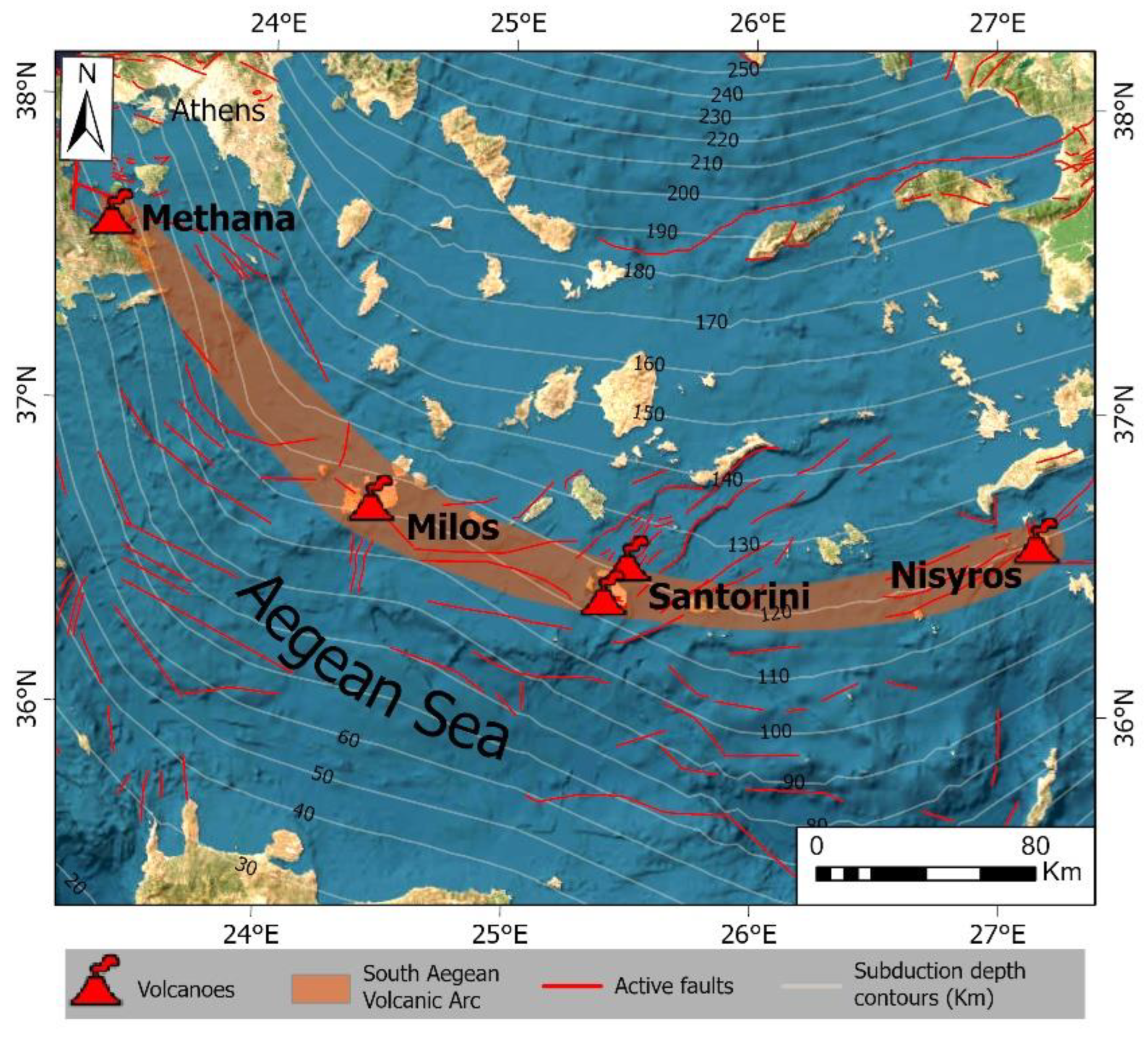
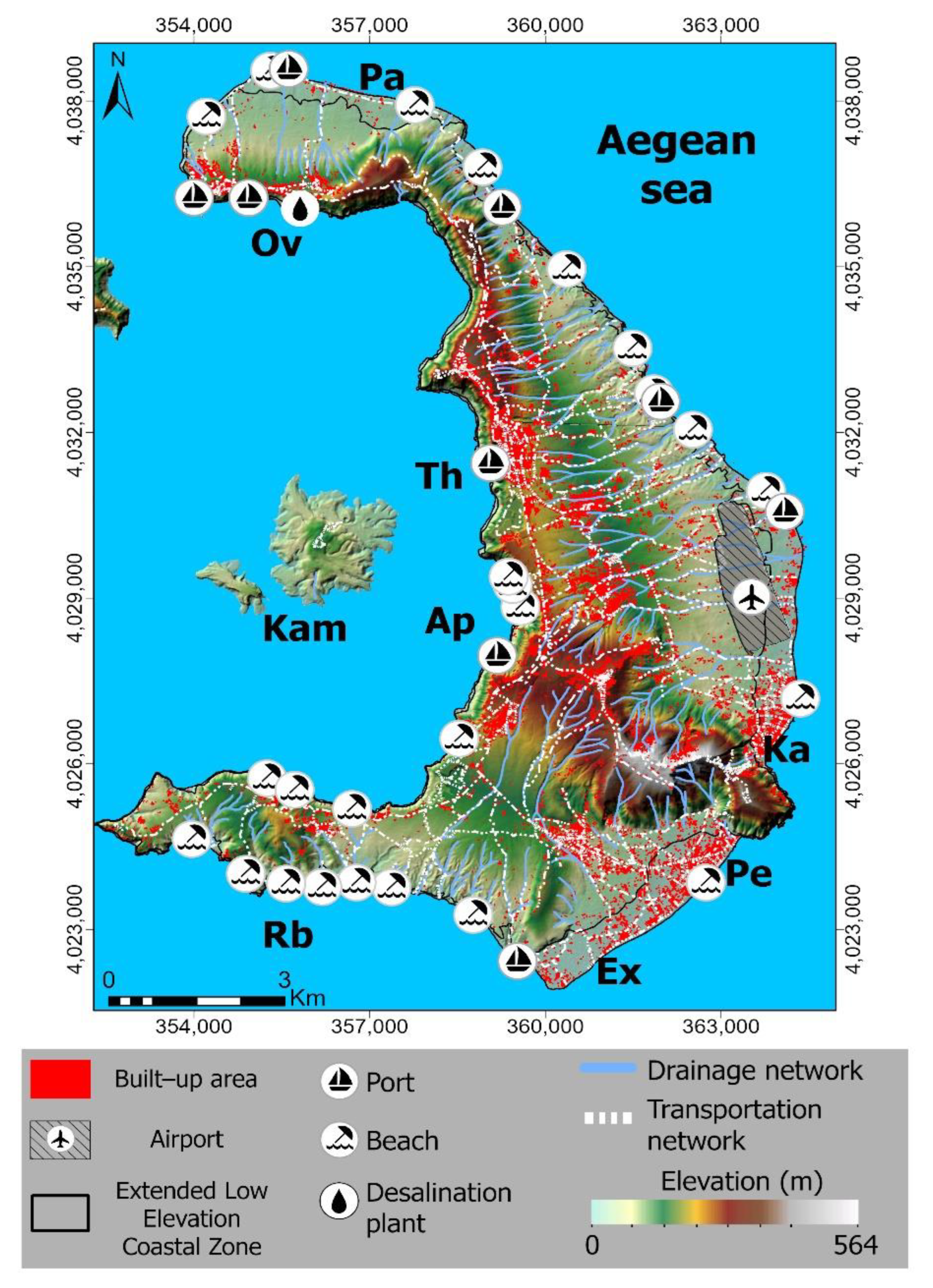
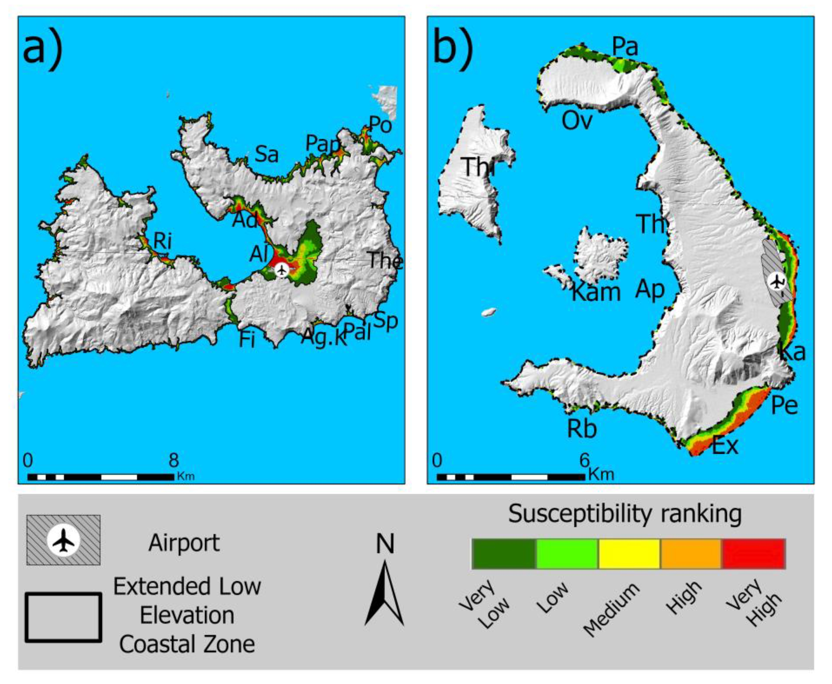
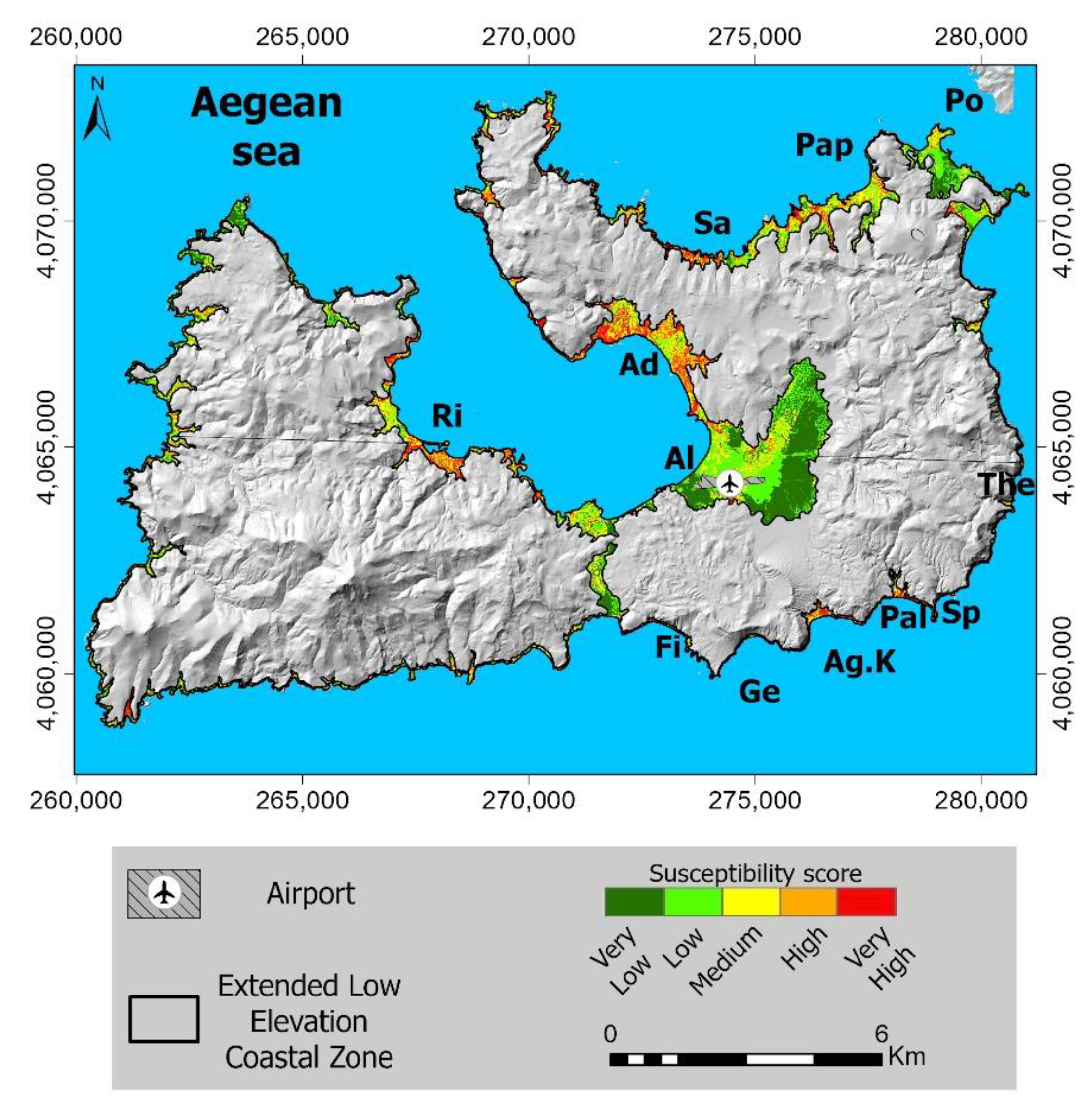
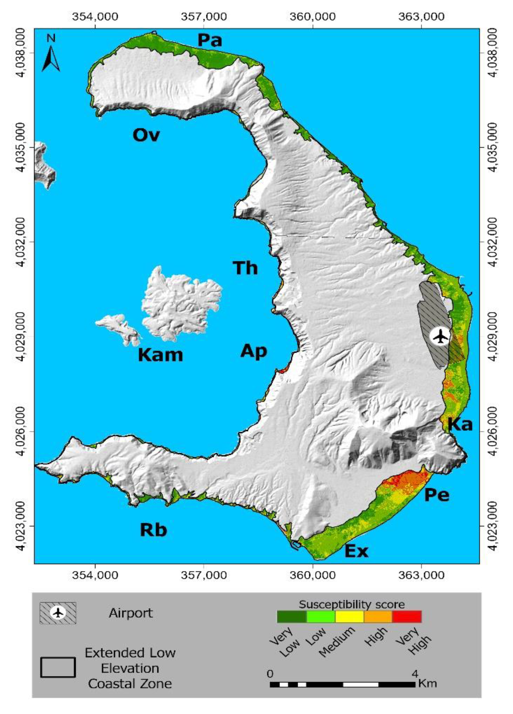
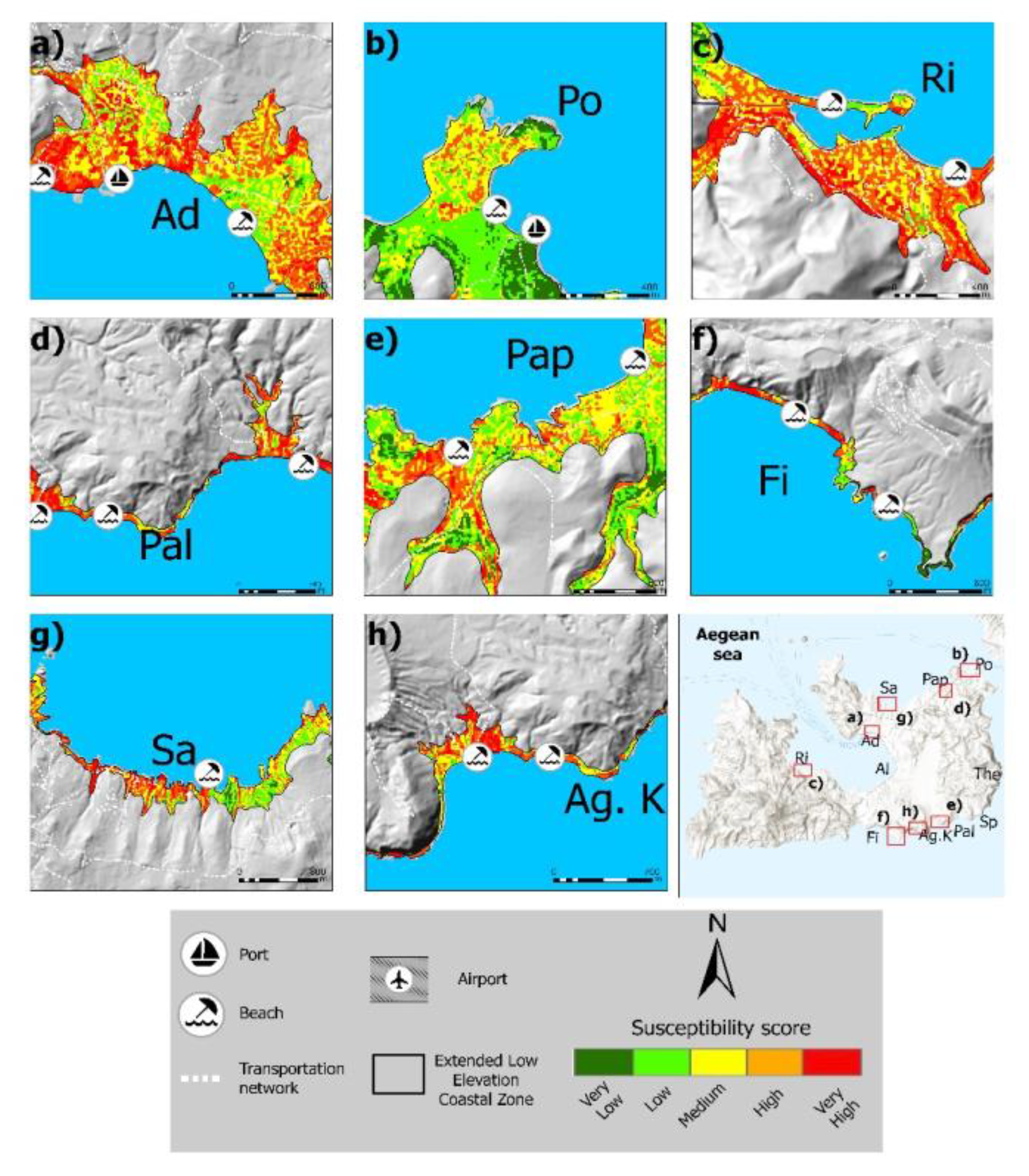
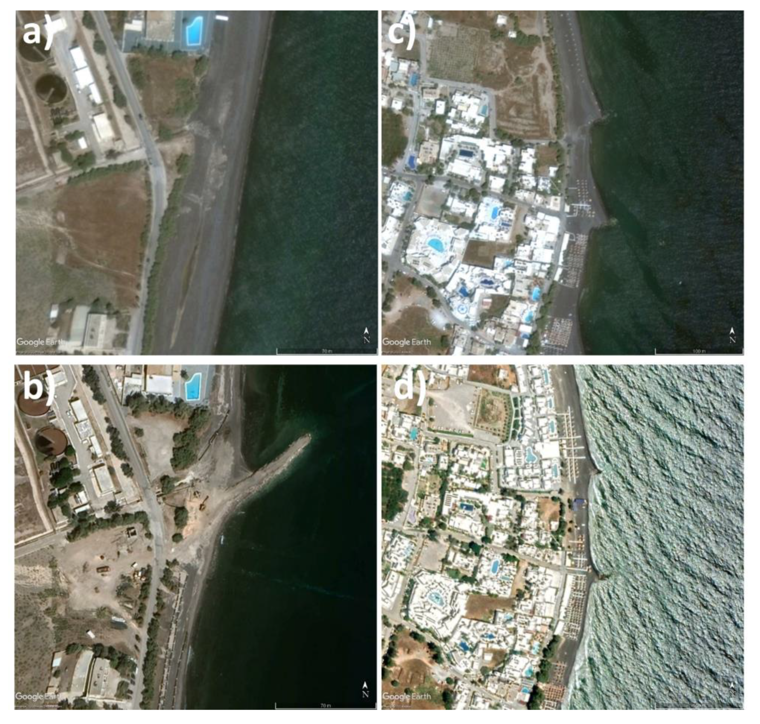
2. Study Areas
3. Materials and Methods
3.1. Data Collection
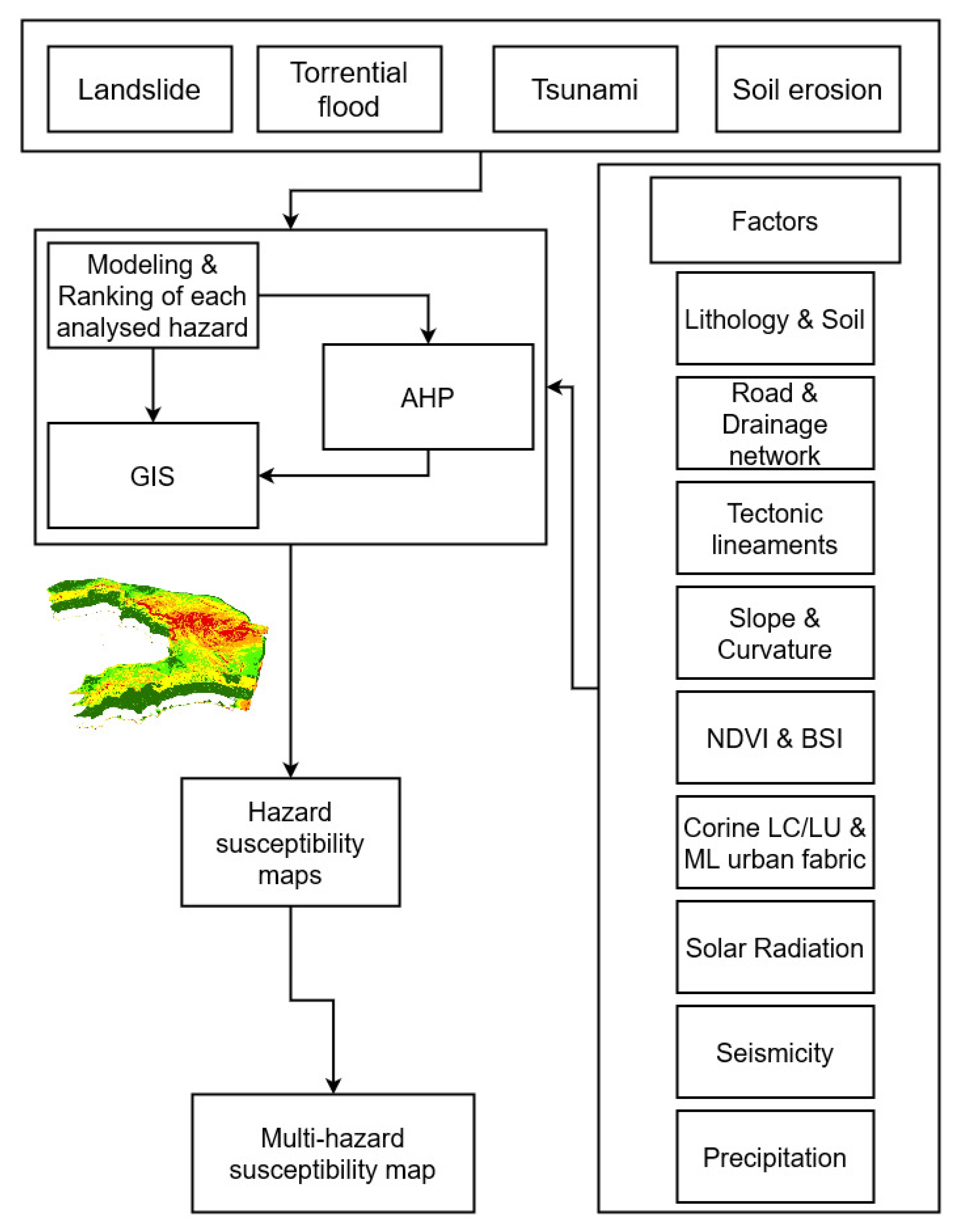
3.2. Methodology
3.3. Landslide Susceptibility
Conditioning Factors
- Lithology
- Slope gradient
- Slope Curvature
- Annual Solar Radiation (WH/m2)
- Proximity to tectonic structures (m)
- Distance from the main road network
- Mean annual precipitation
- Seismic parameters
3.4. FFPI Methodology
Torrential Flood Factors
- Slope gradient
- Soil type
- Land cover/Land use
- Vegetation density

| Causal Factor | Class | Rank Values |
|---|---|---|
| Slope Gradient (°) | <7.50 | 5 |
| 7.51–16.44 | 4 | |
| 16.45–27.70 | 3 | |
| 27.71–40.39 | 2 | |
| >40.40 | 1 | |
| Vegetation Density | <7.43 | 5 |
| 7.43–8.04 | 4 | |
| 8.04–8.45 | 3 | |
| 8.45–9.46 | 2 | |
| >9.46 | 1 | |
| Soil Type | Alluvials | 5 |
| Andosols | 3 | |
| Cambisol | 2 | |
| Regosols | 1 | |
| Land cover/Land use | Airports & Ports Mineral extraction sites Non-irrigated arable land Sparsely vegetated areas Salines | 5 |
| Complex cultivation patterns & Pastures Land principally occupied by agriculture, with significant areas of natural vegetation Bare rocks | 4 | |
| Olive groves Natural grasslands | 3 | |
| Continuous urban fabric & Discontinuous urban fabric | 2 | |
| Sclerophyllous vegetation | 1 |
3.5. Soil Loss Susceptibility Assessment–Revised Universal Soil Loss Equation (RUSLE)
RUSLE Factors
- Rainfall (R) factor
- Soil Erodibility (K) factor
- Topographic Slope Length & Steepness (LS) factor
- Cropping and Land-Cover (C) factor
- Conservation Practices (P) factor
3.6. Tsunami Run-Up Scenario
3.7. Analytical Hierarchy Process
4. Results
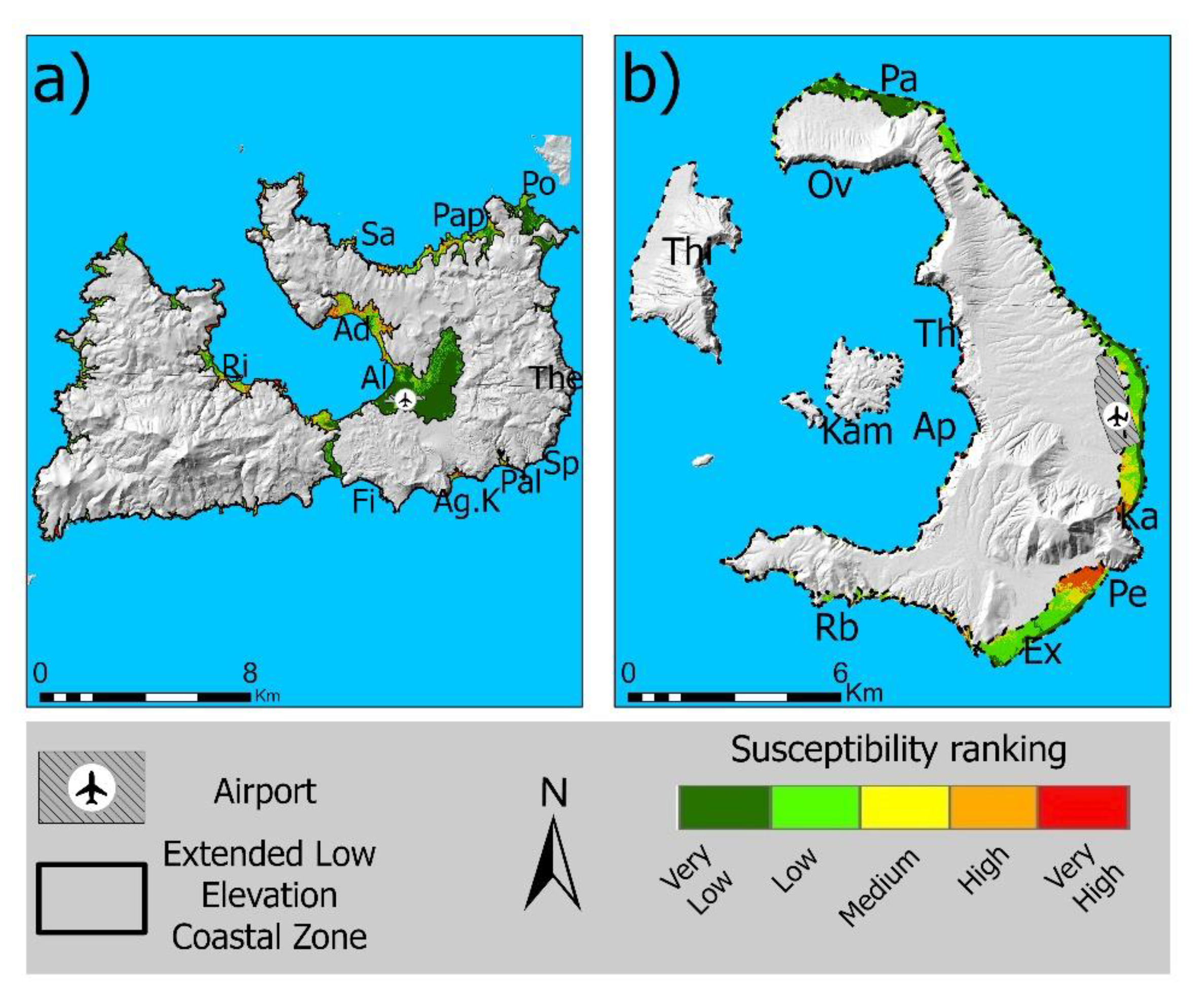
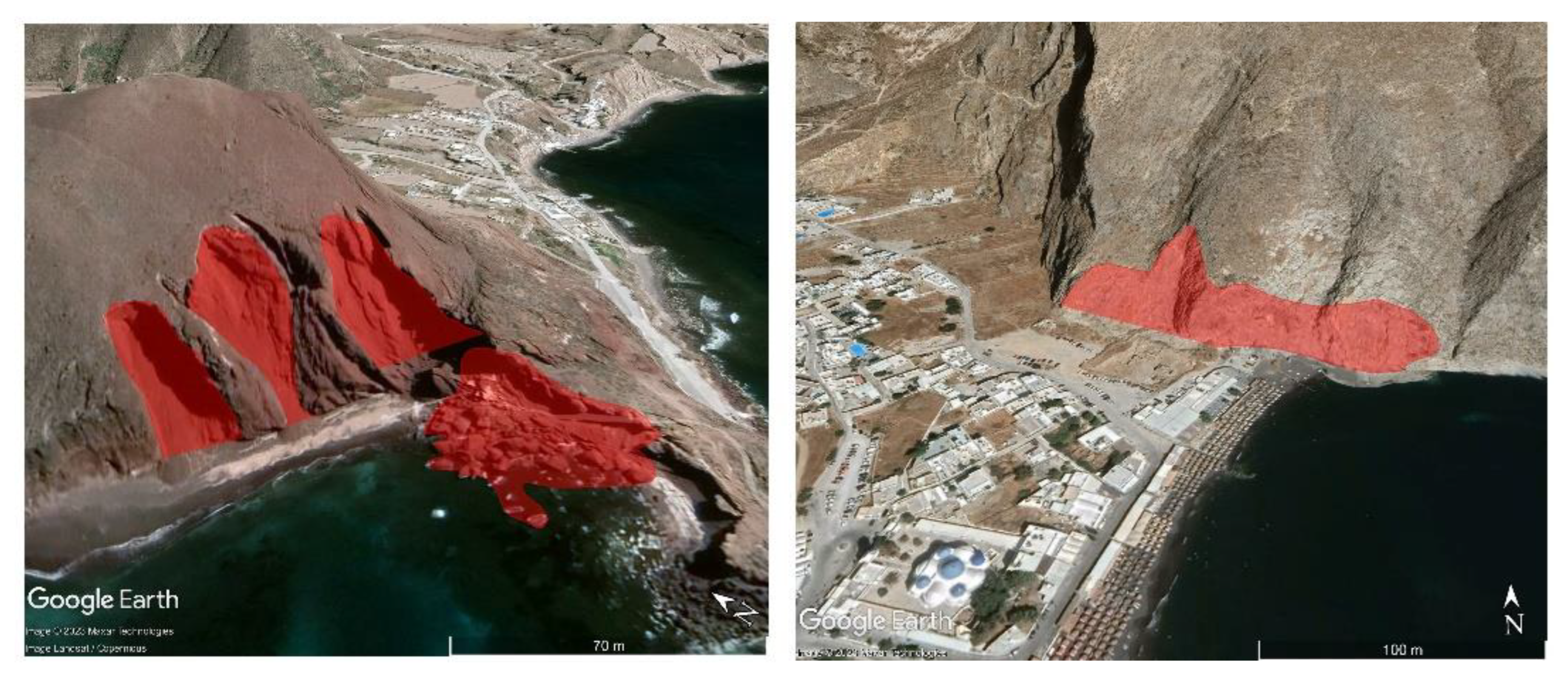
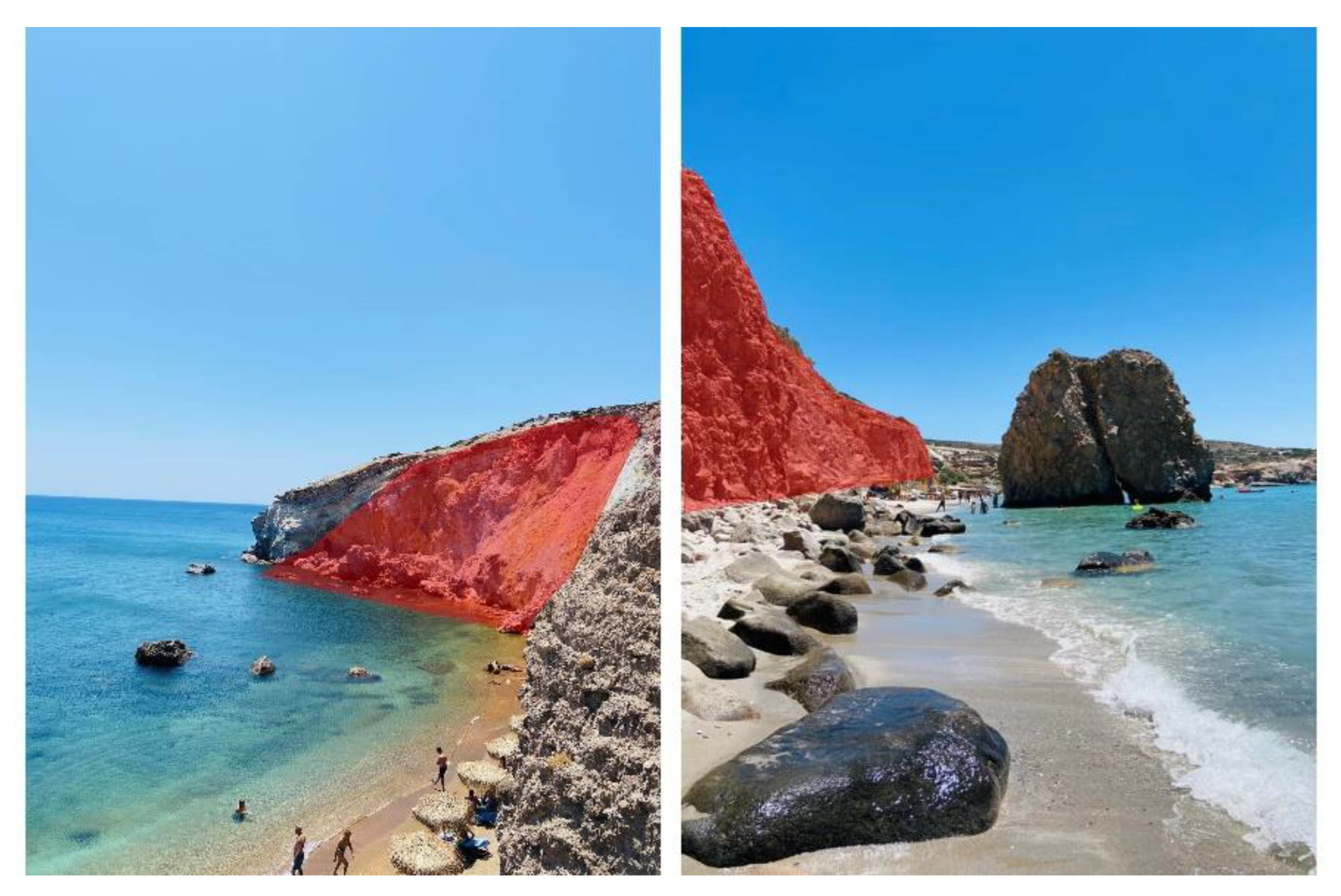
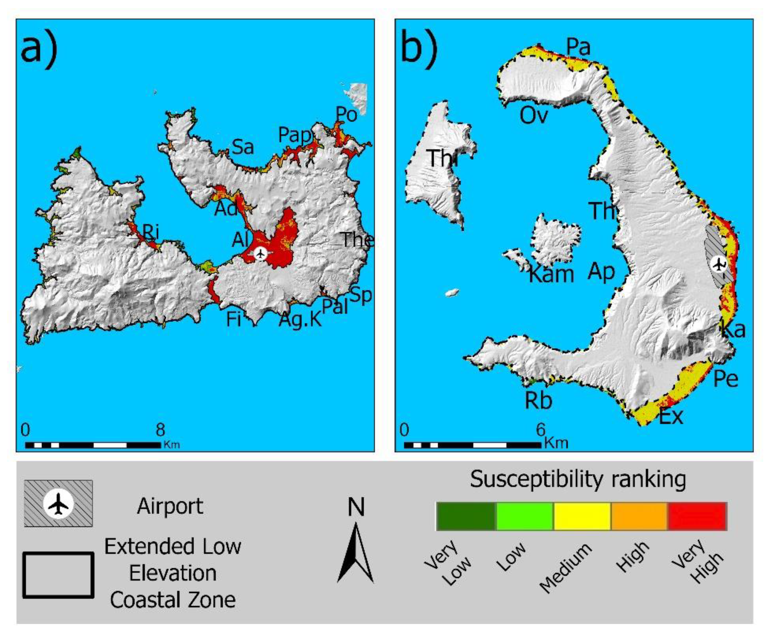
4.1. Susceptibility to Landslides
4.2. Susceptibility to Torrential Floods
4.3. Soil Loss
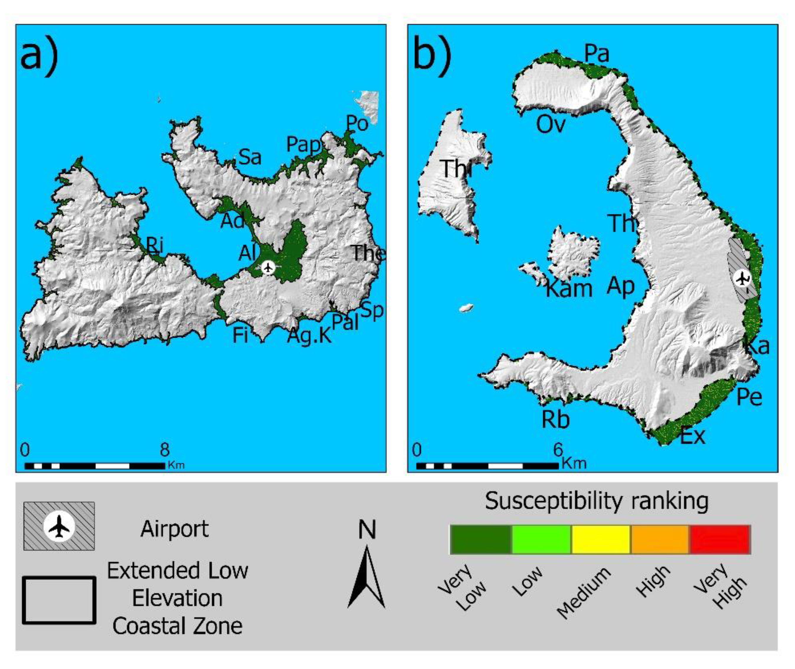
4.4. Susceptibility to Tsunami
4.5. Total Susceptibility to Hazards
4.6. Result Validation
5. Discussion and Conclusions
Author Contributions
Funding
Data Availability Statement
Acknowledgments
Conflicts of Interest
References
- Mestanza-Ramón, C.; Pranzini, E.; Anfuso, G.; Botero, C.M.; Chica-Ruiz, J.A.; Mooser, A. An Attempt to Characterize the “3S” (Sea, Sun, and Sand) Parameters: Application to the Galapagos Islands and Continental Ecuadorian Beaches. Sustainability 2020, 12, 3468. [Google Scholar] [CrossRef] [Green Version]
- OECD. Socio-Economic Trends, Growth Potential and Opportunities. Available online: https://www.oecd-ilibrary.org/sites/72a96a49-en/index.html?itemId=/content/component/72a96a49-en (accessed on 10 March 2023).
- ELSTAT. Greece with Numbers, ELSTAT. 2021. Available online: https://www.statistics.gr/ (accessed on 17 January 2023).
- Nomikou, P.; Krassakis, P.; Kazana, S.; Papanikolaou, D.; Koukouzas, N. The Volcanic Relief Within the Kos-Nisyros-Tilos Tectonic Graben at the Eastern Edge of the Aegean Volcanic Arc, Greece and Geohazard Implications. Geosciences 2021, 11, 231. [Google Scholar] [CrossRef]
- IPCC. Special Report Global Warming of 1.5 °C. Available online: https://www.ipcc.ch/sr15/ (accessed on 23 December 2021).
- Alexandrakis, G.; Karditsa, A.; Poulos, S.; Ghionis, G.; Kampanis, N.A. An assessment of the vulnerability to erosion of the coastal zone due to a potential rise of sea level: The case of the Hellenic Aegean coast. In Encyclopedia of Life Support Systems (EOLSS), Developed under the Auspices of the UNESCO; Sydow, A., Ed.; Eolss Publishers: Oxford, UK, 2010. [Google Scholar]
- Krassakis, P.; Karavias, A.; Nomikou, P.; Karantzalos, K.; Koukouzas, N.; Kazana, S.; Parcharidis, I. Geospatial Intelligence and Machine Learning Technique for Urban Mapping in Coastal Regions of South Aegean Volcanic Arc Islands. Geomatics 2022, 2, 297–322. [Google Scholar] [CrossRef]
- Akgun, A.; Türk, N. Landslide susceptibility mapping for Ayvalik (Western Turkey) and its vicinity by multicriteria decision analysis. Environ. Earth Sci. 2009, 61, 595–611. [Google Scholar] [CrossRef]
- Hunter, N.M.; Bates, P.D.; Horritt, M.S.; Wilson, M.D. Simple spatially-distributed models for predicting food inundation: A review. Geomorphology 2007, 90, 208–225. [Google Scholar] [CrossRef]
- Kamp, U.; Owen, L.A.; Growley, B.J.; Khattak, G.A. Back analysis of landslide susceptibility zonation mapping for the 2005 Kashmir earthquake: An assessment of the reliability of susceptibility zoning maps. Nat. Hazards 2009, 54, 54. [Google Scholar] [CrossRef]
- Pourghasemi, H.R.; Kariminejad, N.; Amiri, M.; Edalat, M.; Zarafshar, M.; Blaschke, T.; Cerda, A. Assessing and mapping multi-hazard risk susceptibility using a machine learning technique. Sci. Rep. 2020, 10, 3203. [Google Scholar] [CrossRef] [Green Version]
- UN. Johannsburg Plan of Implementation of the World Summit on Sustainable Development; Technical Report; United Nations: New York, NY, USA, 2002. Available online: https://digitallibrary.un.org/record/478154?ln=en (accessed on 10 March 2023).
- van Westen, C.J.; Kappes, M.S.; Luna, B.Q.; Frigerio, S.; Glade, T.; Malet, J.P. Medium-Scale Multi-hazard Risk Assessment of Gravitational Processes. In Mountain Risks: From Prediction to Management and Governance. Advances in Natural and Technological Hazards Research; Van Asch, T., Corominas, J., Greiving, S., Malet, J.P., Sterlacchini, S., Eds.; Springer: Dordrecht, The Netherland, 2014; Volume 34. [Google Scholar] [CrossRef]
- Marzocchi, W.; Mastellone, M.; Di Ruocco, A. Principles of Multi-Risk Assessment: Interactions amongst Natural and Man-Induced Risks; Project Report; European Commission: Brussels, Belgium, 2009; printed in Luxembourg and coordinated by Dopiavoce, Napoli (Italy).
- Zuccaro, G.; Leone, M. Volcanic Crisis Management and Mitigation Strategies: A Multi-Risk Framework Case Study. Earthzine. 2011. Available online: https://earthzine.org/2011/03/21/volcanic-crisis-management-and-mitigation-strategies-a-multi-risk-framework-case-study/ (accessed on 20 September 2019).
- Fan, X.; Scaringi, G.; Korup, O.; West, A.J.J.; van Westen, C.; Tanyas, H.; Hovius, N.; Hales, T.C.; Jibson, R.W.; Allstadt, K.E.; et al. Earthquake-induced chains of geologic hazards: Patterns, mechanisms, and impacts. Rev. Geophys. 2019, 57, 421–503. [Google Scholar] [CrossRef] [Green Version]
- Bathrellos, G.D.; Skilodimou, H.D.; Chousianitis, K.; Youssef, A.M.; Pradhan, B. Suitability estimation for urban development using multi-hazard assessment map. Sci. Total Environ. 2017, 575, 119–134. [Google Scholar] [CrossRef]
- Kaur, H.; Gupta, S.; Parkash, S.; Thapa, R. Application of geospatial technologies for multi-hazard mapping and characterization of associated risk at local scale. Ann. GIS 2018, 24, 33–46. [Google Scholar] [CrossRef] [Green Version]
- Skilodimou, H.D.; Bathrellos, G.D.; Chousianitis, K.; Youssef, A.M.; Pradhan, B. Multi-hazard assessment modeling via multi-criteria analysis and GIS: A case study. Environ. Earth Sci. 2019, 78, 47. [Google Scholar] [CrossRef]
- Hoffmann, G.; Reicherter, K.R. Geohazards: Coastal Disasters. In Encyclopedia of Marine Geosciences; Harff, J., Meschede, M., Petersen, S., Thiede, J., Eds.; Springer: Dordrecht, The Netherland, 2015. [Google Scholar] [CrossRef]
- Nicholls, R.J.; Cazenave, A.A. Sea-Level Rise and Its Impact on Coastal Zones. Science 2010, 328, 1517–1520. [Google Scholar] [CrossRef] [PubMed]
- IPCC. Climate Change 2013: The Physical Science Basis. In Contribution of Working Group I to the Fifth Assessment Report of the Intergovernmental Panel on Climate Change; Stocker, T.F., Qin, D., Plattner, G.K., Tignor, M., Allen, S.K., Boschung, J., Nauels, A., Xia, Y., Bex, V., Midgley, P.M., Eds.; Cambridge University Press: Cambridge, UK; New York, NY, USA, 2013; p. 1535. [Google Scholar]
- Islam, M.A.; Mitra, D.; Dewan, A.; Akhter, S.H. Coastal multi-hazard vulnerability assessment along the Ganges deltaic coast of Bangladesh–A geospatial approach. Ocean. Coast. Manag. 2016, 127, 1–15. [Google Scholar] [CrossRef]
- Vitousek, S.; Barnard, P.L.; Fletcher, C.H.; Frazer, N.; Erikson, L.; Storlazzi, C.D. Doubling of coastal flooding frequency within decades due to sea-level rise. Sci. Rep. 2017, 7, 1399. [Google Scholar] [CrossRef] [Green Version]
- Maramai, A.; Brizuela, B.; Graziani, L. The euro-mediterranean tsunami catalogue. Ann. Geophys. 2014, 57, s0435. Available online: http://www.annalsofgeophysics.eu/index.php/annals/article/view/6437/6380 (accessed on 10 March 2023).
- Papazachos, B.C.; Papazachou, C. The Earthquakes of Greece; Ziti Publ. Co.: Thessaloniki, Greece, 2003. [Google Scholar]
- Sørensen, M.B.; Spada, M.; Babeyko, A.; Wiemer, S.; Grünthal, G. Probabilistic tsunami hazard in the Mediterranean Sea. J. Geophys. Res. 2012, 117, 1–15. [Google Scholar] [CrossRef] [Green Version]
- Papadopoulos, G.A. Tsunami hazard in the Eastern Mediterranean: Strong earthquakes and tsunamis in the Corinth Gulf, Central Greece. Nat. Hazards 2003, 29, 437–464. [Google Scholar] [CrossRef]
- Papadopoulos, G.A.; Daskalaki, E.; Fokaefs, A.; Giraleas, N. Tsunami hazards in the Eastern Mediterranean: Strong earthquakes and tsunamis in the East Hellenic arc and Trench System. Nat. Hazards Earth Syst. Sci. 2007, 7, 57–64. [Google Scholar] [CrossRef] [Green Version]
- Ighodaro, I.D.; Lategan, F.S.; Yusuf, S.F. The impact of soil erosion on agricultural potential and performance of Sheshegu community farmers in the Eastern Cape of South Africa. J. Agric. Sci. 2013, 5, 140. [Google Scholar] [CrossRef] [Green Version]
- De Souza, F.G.; Melo, V.F.; Araújo, W.F.; Araújo, T.H.D.C. Losses of soil, water, organic carbon and nutrients caused by water erosion in different crops and natural savannah in the northern Amazon. Ambient. E Agua Interdiscip. J. Appl. Sci. 2018, 14, 1–16. [Google Scholar] [CrossRef]
- Durlević, U.; Momčilović, A.; Ćurić, V.; Dragojević, M. Gis application in analysis of erosion intensity in the Vlasina River Basin. Glas. Srp. Geogr. Društva 2019, 99, 17–36. [Google Scholar] [CrossRef]
- Stefanidis, S.; Chatzichristaki, C.; Stefanidis, P. An ArcGIS toolbox for estimation and mapping soil erosion. J. Environ. Prot. Ecol. 2021, 22, 689–696. [Google Scholar]
- Dominey-Howes, D.; Cundy, A.; Croudace, I. High energy marine flood deposits on Astypalaea Island, Greece: Possible evidence for the AD 1956 southern Aegean tsunami. Mar. Geol. 2000, 163, 303–315. [Google Scholar] [CrossRef]
- Ambraseys, N.N. The seismic sea wave of 9 July 1956, in the Greek Archipelago. J. Geophys. Res. 1960, 65, 1257–1265. [Google Scholar] [CrossRef]
- Stiros, S.C.; Marangou, L.; Arnold, M. Quaternary uplift and tilting of Amorgos Island (southern Aegean) and the 1956 earthquake. Earth Planet. Sci. Lett. 1994, 128, 65–76. [Google Scholar] [CrossRef]
- Dominey-Howes, D.T.M. Sedimentary deposits associated with the July 9th 1956 Aegean Sea Tsunami. Phys. Chem. Earth 1996, 21, 51–55. [Google Scholar] [CrossRef]
- Batzakis, D.-V.; Misthos, L.-M.; Voulgaris, G.; Tsanakas, K.; Andreou, M.; Tsodoulos, I.; Karymbalis, E. Assessment of Building Vulnerability to Tsunami Hazard in Kamari (Santorini Island, Greece). J. Mar. Sci. Eng. 2020, 8, 886. [Google Scholar] [CrossRef]
- Dominey-Howes, D. A re-analysis of the Late Bronze Age eruption and tsunami of Santorini, Greece, and the implications for the volcano–tsunami hazard. J. Volcanol. Geoth. Res. 2004, 130, 107–132. [Google Scholar] [CrossRef]
- Fytikas, M.; Marinelli, G. Geology and Geothermics of the Island of Milos (Greece). (No. NP-22876). Ph.D. Thesis, Institute of Geology and Mining Research, Athens, Greece, Istituto di Mineralogia e Petrografia, Pisa University, Pisa, Italy, 1976. [Google Scholar] [CrossRef] [Green Version]
- Nomikou, P.; Papanikolaou, D. The morphotectonic structure of Kos-Nisyros-Tilos volcanic area based on onshore and offshore data. In Proceedings of the XIX Congress of the Carpathian-Balkan Geological Association, Thessaloniki, Greece, 23–26 September 2010; Volume 99, pp. 557–564. [Google Scholar]
- Microsoft. Microsoft/Roaddetections: Road Detections from Microsoft Maps Aerial Imagery. Available online: https://github.com/microsoft/RoadDetections/?url= (accessed on 1 February 2023).
- Copernicus Open Access Hub. Available online: https://scihub.copernicus.eu/ (accessed on 23 December 2022).
- OpenStreetMap. Available online: https://www.openstreetmap.org/#map=9/36.6904/25.0516 (accessed on 20 November 2022).
- CLC. Copernicus Land Monitoring Service. 2018. Available online: https://land.copernicus.eu/pan-european/corine-land-cover/clc2018 (accessed on 10 November 2022).
- Pichler, H.; Gunther, D.; Kussmaul, S. Geological Map of Greece (Scale 1:50,000), Thira Island; Institute of Geology and Mineral Exploration: Athens, Greece, 1980. [Google Scholar]
- Fitikas, M. Geological Map of Greece (Scale 1:25,000), Milos Islands; Institute of Geology and Mineral Exploration: Athens, Greece, 1977. [Google Scholar]
- Ganas, A.; Oikonomou, I.A.; Tsimi, C. NOAfaults: A digital database for active faults in Greece. Bull. Geol. Soc. Greece 2017, 47, 518–530. [Google Scholar] [CrossRef] [Green Version]
- Kassaras, I.; Kapetanidis, V.; Ganas, A.; Tzanis, A.; Kosma, C.; Karakonstantis, A.; Valkaniotis, S.; Chailas, S.; Kouskouna, V.; Papadimitriou, P. The New Seismotectonic Atlas of Greece (v1.0) and Its Implementation. Geosciences 2020, 10, 447. [Google Scholar] [CrossRef]
- Database of Individual Seismogenic Sources (DISS). Version 3.3.0: A Compilation of Potential Sources for Earthquakes Larger than M 5.5 in Italy and Surrounding Areas. [Data Set]. Istituto Nazionale di Geofisica e Vulcanologia—INGV. 2021. Available online: https://data.ingv.it/dataset/488#additional-metadata (accessed on 10 March 2023).
- HNMS—Climate Atlas. Available online: http://climatlas.hnms.gr/sdi/?lang=EN (accessed on 11 February 2023).
- European Soil Data Centre (ESDAC). Available online: https://esdac.jrc.ec.europa.eu (accessed on 25 January 2021).
- Tzeng, G.-H.; Huang, J.-J. Multiple Attribute Decision Making: Methods and Applications, 1st ed.; Chapman and Hall/CRC: Boca Raton, FL, USA, 2011. [Google Scholar] [CrossRef]
- Jenks, G.F. The data model concept in statistical mapping. Int. Yearb. Cartogr. 1967, 7, 186–190. [Google Scholar]
- Chen, J.; Yang, S.T.; Li, H.W.; Zhang, B.; Lv, J.R. Research on Geographical Environment Unit Division Based on the Method of Natural Breaks (Jenks). ISPRS Int. Archiv. Photogram. Remote Sens. Spatial Inf. Sci. 2013, XL4, 47–50. [Google Scholar] [CrossRef] [Green Version]
- Hudson, J.A. Rock Engineering Systems, Theory and Practice; Ellis Horwood Limited: Chichester, UK, 1992; p. 185. [Google Scholar]
- Hudson, J.A.; Harrison, J.P. A new approach to studying complete rock engineering problems. Q. J. Eng. Geol. 1992, 25, 93–105. [Google Scholar] [CrossRef]
- Jiao, Y.; Hudson, J. The fully-coupled model for rock engineering systems. Int. J. Rock Mech. Min. Sci. Géoméch. Abstr. 1995, 32, 491–512. [Google Scholar] [CrossRef]
- Khalokakaie, R.; Naghadehi, M.Z. Ranking the rock slope stability potential using the interaction matrix (IM) technique; a case study in Iran. Arab. J. Geosci. 2012, 5, 263–273. [Google Scholar] [CrossRef]
- Krassakis, P.; Loupasakis, C. Assessment of Landslide Susceptibility Using Geospatial Analysis and Interferometry Data, in the Mountainous Municipalities of Nafpaktia and Karpenisi. In Proceedings of the 1st Conference of the Remote Sensing and Space Applications Committee of the Geological Society of Greece, 2018; pp. 43–44. Available online: http://etde.space.noa.gr/wp-content/uploads/2019/08/Book-of-Abstracts-1st-conference-of-the-Remote-Sensing-and-Space-Applications-Committee-of-the-Geological-Society-of-Greece_final.pdf (accessed on 9 February 2023).
- Krassakis, P.; Ioannidou, A.; Tsangaratos, P.; Loupasakis, C. Landslide Susceptibility Mapping of the Aitoloakarnania and Evrytania Regional Units, Western Greece, Updated with the Exten-Sive Catastrophic of Winter 2015. In Proceedings of the 1st International Conference on Environmental Design (ICED2020), Patras, Greece, 2020; p. 431. Available online: https://iced.eap.gr/wp-content/uploads/ICED2020/Papers/IDED2020_full_paper_9.pdf (accessed on 9 February 2023).
- Adam, S.; Athinelis, I.; Krassakis, P.; Nomikou, P. Landslide Susceptibility Assessment of Heraklion Prefecture in Crete, Greece. Bull. Geol. Soc. Greece 2022, 59, 23–67. [Google Scholar] [CrossRef]
- Antoniou, V.; Lappas, S.; Leoussis, C.; Nomikou, P. Landslide Risk Assessment of the Santorini Volcanic Group. In GISTAM—3rd International Conference on Geographical Information Systems Theory, Applications and Management; SciTePress: Porto, Portugal, 2017; pp. 131–141. [Google Scholar] [CrossRef] [Green Version]
- Kouli, M.; Loupasakis, C.; Soupios, P.; Vallianatos, F. Landslide hazard zonation in high risk areas of Rethymno Prefecture, Crete Island, Greece. Nat. Hazards 2009, 52, 599–621. [Google Scholar] [CrossRef]
- Psomiadis, E.; Papazachariou, A.; Soulis, K.X.; Alexiou, D.-S.; Charalampopoulos, I. Landslide Mapping and Susceptibility Assessment Using Geospatial Analysis and Earth Observation Data. Land 2020, 9, 133. [Google Scholar] [CrossRef]
- Ladas, I.; Fountoulis, I.; Mariolakos, I. Using GIS & Multicriteria Decision analysis in landslide susceptibility mapping—A case study in Messinia prefecture area (SW Peloponnesus, Greece). Bull. Geol. Soc. Greece 2007, 40, 1973–1985. [Google Scholar]
- Ali, S.A.; Parvin, F.; Vojteková, J.; Costache, R.; Linh, N.T.T.; Pham, Q.B.; Vojtek, M.; Gigović, L.; Ahmad, A.; Ghorbani, M.A. GIS-based landslide susceptibility modeling: A comparison between fuzzy multi-criteria and machine learning algorithms. Geosci. Front. 2020, 12, 857–876. [Google Scholar] [CrossRef]
- Teja, T.S.; Dikshit, A.; Satyam, N. Determination of Rainfall Thresholds for Landslide Prediction Using an Algorithm-Based Approach: Case Study in the Darjeeling Himalayas, India. Geosciences 2019, 9, 302. [Google Scholar] [CrossRef] [Green Version]
- Li, F.; Torgoev, I.; Zaredinov, D.; Li, M.; Talipov, B.; Belousova, A.; Kunze, C.; Schneider, P. Influence of Earthquakes on Landslide Susceptibility in a Seismic Prone Catchment in Central Asia. Appl. Sci. 2021, 11, 3768. [Google Scholar] [CrossRef]
- Durlević, U.; Novković, I.; Lukić, T.; Valjarević, A.; Samardžić, I.; Krstić, F.; Batoćanin, N.; Mijatov, M.; Ćurić, V. Multihazard susceptibility assessment: A case study—Municipality of Štrpce (Southern Serbia). Open Geosci. 2021, 13, 1414–1431. [Google Scholar] [CrossRef]
- Smith, G. Flash Flood Potential: Determining the Hydrologic Response of FFMP Basins to Heavy Rain by Analyzing Their Physiographic Characteristics; NWS Colorado Basin River Forecast Center: Salt Lake City, UT, USA, 2003. Available online: http://www.cbrfc.noaa.gov/papers/ffp_wpap.pdf (accessed on 19 February 2019).
- Smith, G.E. Development of a Flash Flood Potential Index Using Physiographic Data Sets within a Geographic Information System. Master’s Thesis, University of Utah, Salt Lake City, UT, USA, 2010. [Google Scholar]
- Minea, G. Assessment of the flash flood potential of Bâsca River Catchment (Romania) based on physiographic factors. Open Geosci. 2013, 5, 344–353. [Google Scholar] [CrossRef] [Green Version]
- Pham, B.T.; Avand, M.; Janizadeh, S.; Van Phong, T.; Al-Ansari, N.; Ho, L.S.; Das, S.; Van Le, H.; Amini, A.; Bozchaloei, S.K.; et al. GIS Based Hybrid Computational Approaches for Flash Flood Susceptibility Assessment. Water 2020, 12, 683. [Google Scholar] [CrossRef] [Green Version]
- Al-Areeq, A.M.; Abba, S.I.; Yassin, M.A.; Benaaf, M.; Ghaleb, M.; Aljundi, I.H. Computational Machine Learning Approach for Flood Susceptibility Assessment Integrated with Remote Sensing and GIS Techniques from Jeddah, Saudi Arabia. Remote Sens. 2022, 14, 5515. [Google Scholar] [CrossRef]
- Cao, C.; Xu, P.; Wang, Y.; Chen, J.; Zheng, L.; Niu, C. Flash Flood Hazard Susceptibility Mapping Using Frequency Ratio and Statistical Index Methods in Coalmine Subsidence Areas. Sustainability 2016, 8, 948. [Google Scholar] [CrossRef] [Green Version]
- Mohamed, S.A.; El-Raey, M.E. Vulnerability assessment for flash floods using GIS spatial modeling and remotely sensed data in El-Arish City, North Sinai, Egypt. Nat. Hazards 2019, 102, 707–728. [Google Scholar] [CrossRef]
- Waqas, H.; Lu, L.; Tariq, A.; Li, Q.; Baqa, M.F.; Xing, J.; Sajjad, A. Flash Flood Susceptibility Assessment and Zonation Using an Integrating Analytic Hierarchy Process and Frequency Ratio Model for the Chitral District, Khyber Pakhtunkhwa, Pakistan. Water 2021, 13, 1650. [Google Scholar] [CrossRef]
- Rikimaru, A. Development of forest canopy density mapping and monitoring model using indices of vegetation, bare soil and shadow. In Proceedings of the 18th Asian Conference on Remote Sensing, Kuala Lumpur, Malaysia, 1–6 June 1997. [Google Scholar]
- Rouibah, K.; Belabbas, M. Applying Multi-Index approach from Sentinel-2 Imagery to Extract Urban Area in dry season (Semi-Arid Land in North East Algeria). Rev. Teledetección 2020, 56, 89–101. [Google Scholar] [CrossRef]
- Tselka, I.; Krassakis, P.; Rentzelos, A.; Koukouzas, N.; Parcharidis, I. Assessing Post-Fire Effects on Soil Loss Combining Burn Severity and Advanced Erosion Modeling in Malesina, Central Greece. Remote Sens. 2021, 13, 5160. [Google Scholar] [CrossRef]
- Bewket, W.; Teferi, E. Assessment of soil erosion hazard and prioritization for treatment at the watershed level: Case study in the Chemoga watershed, Blue Nile basin, Ethiopia. Land Degrad. Dev. 2009, 20, 609–622. [Google Scholar] [CrossRef]
- Wischmeier, W.H.; Smith, D.D. Predicting rainfall erosion losses: A guide to conservation planning. In Agriculture Handbook; No. 537; US Department of Agriculture Science and Education Administration: Washington, DC, USA, 1978; pp. 1–69. [Google Scholar]
- Renard, K.G.; Foster, G.R.; Weesies, G.A.; McCool, D.; Yoder, D. Predicting soil erosion by water: A guide to conservation planning with the revised universal soil loss equation (rusle). In Agriculture Handbook; US Department of Agriculture: Washington, DC, USA, 1997; Volume 703, pp. 1–251. [Google Scholar]
- Yang, T.; Tedersoo, L.; Lin, X.; Fitzpatrick, M.C.; Jia, Y.; Liu, X.; Ni, Y.; Shi, Y.; Lu, P.; Zhu, J.; et al. Distinct fungal successional trajectories following wildfire between soil horizons in a cold-temperate forest. New Phytol. 2020, 227, 572–587. [Google Scholar] [CrossRef]
- Kinnell, P. Event soil loss, runoff and the Universal Soil Loss Equation family of models: A review. J. Hydrol. 2010, 385, 384–397. [Google Scholar] [CrossRef]
- Zhang, H.; Wei, J.; Yang, Q.; Baartman, J.E.; Gai, L.; Yang, X.; Li, S.; Yu, J.; Ritsema, C.J.; Geissen, V. An improved method for calculating slope length (λ) and the LS parameters of the Revised Universal Soil Loss Equation for large watersheds. Geoderma 2017, 308, 36–45. [Google Scholar] [CrossRef]
- Kebede, Y.S.; Endalamaw, N.T.; Sinshaw, B.G.; Atinkut, H.B. Modeling soil erosion using RUSLE and GIS at watershed level in the upper beles, Ethiopia. Environ. Challenges 2020, 2, 100009. [Google Scholar] [CrossRef]
- Covelli, C.; Cimorelli, L.; Pagliuca, D.N.; Molino, B.; Pianese, D. Assessment of Erosion in River Basins: A Distributed Model to Estimate the Sediment Production over Watersheds by a 3-Dimensional LS Factor in RUSLE Model. Hydrology 2020, 7, 13. [Google Scholar] [CrossRef] [Green Version]
- Moore, I.D.; Burch, G.J. Physical Basis of the Length-slope Factor in the Universal Soil Loss Equation. Soil Sci. Soc. Am. J. 1986, 50, 1294–1298. [Google Scholar] [CrossRef]
- Durigon, V.L.; de Carvalho, D.F.; Antunes, M.A.H.; Oliveira, P.T.; Fernandes, M.M. NDVI time series for monitoring RUSLE cover management factor in a tropical watershed. Int. J. Remote Sens. 2014, 35, 441–453. [Google Scholar] [CrossRef]
- Yang, D.; Kanae, S.; Oki, T.; Koike, T.; Musiake, K. Global potential soil erosion with reference to land use and climate changes. Hydrol. Process. 2003, 17, 2913–2928. [Google Scholar] [CrossRef]
- David, W.P. Soil and water conservation planning: Policy issues and recommendations. Philipp. J. Dev. 1988, 15, 47–84. [Google Scholar]
- Iida, K. A relation of earthquake energy to tsunami energy and the estimation of the vertical displacement in a tsunami source. J. Earth Sci. Nagoya Univ. 1963, 11, 49–67. [Google Scholar]
- Saaty, T.L. Modeling unstructured decision problems—The theory of analytical hierarchies. Math. Comput. Simul. 1978, 20, 147–158. [Google Scholar] [CrossRef]
- Krassakis, P.; Karavias, A.; Zygouri, E.; Roumpos, C.; Louloudis, G.; Pyrgaki, K.; Koukouzas, N.; Kempka, T.; Karapanos, D. GIS-Based Assessment of Hybrid Pumped Hydro Storage as a Potential Solution for the Clean Energy Transition: The Case of the Kardia Lignite Mine, Western Greece. Sensors 2023, 23, 593. [Google Scholar] [CrossRef]
- Kyriakopoulos, K.; Gaki-Papanastassiou, K.; Papanastassiou, D.; Vassilopoulos, A.; Komianou, A.; Evelpidou, N. Natural Hazards and Anthropogenic Parameters Affecting Milos Island landscape, Greece. In Conference: HAZARDS, 2006. Available online: https://www.researchgate.net/publication/339254847_Natural_hazards_and_anthropogenic_parameters_affecting_Milos_Island_landscape_Greece (accessed on 10 March 2023).
- Vamvakaris, D.A.; Papazachos, C.B.; Papaioannou, C.A.; Scordilis, E.M.; Karakaisis, G.F. A detailed seismic zonation model for shallow earthquakes in the broader Aegean area. Nat. Hazards Earth Syst. Sci. 2016, 16, 55–84. [Google Scholar] [CrossRef] [Green Version]
- ELSTAT (Hellenic Statistical Authority). 2011 Buildings Census; Hellenic Statistical Authority: Athens, Greece, 2015. [Google Scholar]
- Wang, Y.; Imai, K.; Mulia, I.E.; Ariyoshi, K.; Takahashi, N.; Sasaki, K.; Kaneko, H.; Abe, H.; Sato, Y. Data Assimilation Using High-Frequency Radar for Tsunami Early Warning: A Case Study of the 2022 Tonga Volcanic Tsunami. J. Geophys. Res. Solid Earth 2023, 128, e2022JB025153. [Google Scholar] [CrossRef]


| Data Usage | Data Source | Spatial Resolution/Scale | Temporal Scale | Primary Format |
|---|---|---|---|---|
| NDVI & BSI | Sentinel-2 [43] | 10 m | 2016–2021 | Raster |
| DEM | National Cadastre | 5 m | 2019 | Raster |
| Road network | Open Street Map/Microsoft [44] | - | 2016–2022 | Vector (polylines) |
| Urban fabric and coastline | Krassakis et al. [7] | Vector (polygons/polyline) | ||
| Pan-European/CORINE Land Cover/CLC 2018 | Copernicus–EU [45] | 100 m | 2018 | Vector (polygons) |
| Geology of Milos and Thira islands | HSGME [46,47] | 1:50,000 | 1977, 1980 | Raster |
| Beaches, ports, & airports | ESRI basemap | 1:10,000 | 2021 | Vector (polygons/polylines) |
| Active Faults | National Observatory of Athens [48] | - | 2019 | Vector (polylines) |
| Earthquake epicenters | National and Kapodistrian University of Athens [49] | - | 1900–2020 | Vector (points) |
| Subduction depth contours | European Commission [50] | - | Vector (polylines) | |
| Precipitation (mm) | Hellenic National meteorological service (HNMS) [51] | - | 1971–2020 | Raster (grid) |
| K-factor | Joint Research Centre (JRC) [52] | 500 m | 2015 | Raster (grid) |
| Causal Factor | Class | Rank Values |
|---|---|---|
| Lithology | Debris flows & Scree | 5 |
| Schists & Volcanic rocks | 4 | |
| Volcano-sedimentary rocks | 3 | |
| Sedimentary rocks & Limestones | 2 | |
| Loose Sediments | 1 | |
| Slope Gradient (°) | >40.40 | 5 |
| 27.71–40.39 | 4 | |
| 16.45–27.70 | 3 | |
| 7.51–16.44 | 2 | |
| <7.50 | 1 | |
| Curvature | <−18.72 | 5 |
| −14.78–−3.95 | 4 | |
| −3.95–−0.01 | 3 | |
| >0.01 | 2 | |
| 0.01–−0.01 | 1 | |
| Mean Annual Rainfall (mm) | >431.06 | 5 |
| 422.89–431.05 | 4 | |
| 414.09–422.88 | 3 | |
| 406.08–414.08 | 2 | |
| <406.07 | 1 | |
| Distance from the river network (m) | <149.33 | 5 |
| 149.34–355.56 | 4 | |
| 355.57–640.00 | 3 | |
| 640.00–1073.78 | 2 | |
| >1073.79 | 1 | |
| Distance from the road network (m) | <132.29 | 5 |
| 132.30–321.28 | 4 | |
| 321.29–566.96 | 3 | |
| 566.97–894.54 | 2 | |
| >894.55 | 1 | |
| Distance from tectonic structures (m) | <86.59 | 5 |
| 86.60–188.24 | 4 | |
| 188.25–308.70 | 3 | |
| 308.71–474.35 | 2 | |
| >474.36 | 1 | |
| Annual Solar Radiation (Wh/m2) | >50,094.64 | 5 |
| 42,347.82–50,094.64 | 4 | |
| 35,350.69–42,347.82 | 3 | |
| 26,104.48–35,350.69 | 2 | |
| <26,104.48 | 1 | |
| Earthquake Kernel Density (magnitude/m2) | >0.14 | 5 |
| 0.11–0.14 | 4 | |
| 0.07–0.11 | 3 | |
| 0.04–0.07 | 2 | |
| <0.04 | 1 | |
| Earthquake Depth (km) | <11.52 | 5 |
| 11.52–16.88 | 4 | |
| 16.88–21.61 | 3 | |
| 21.61–27.44 | 2 | |
| >27.44 | 1 |
| P1 | 0 | 1 | 0 | 0 | 2 | 0 | 4 | 3 | 3 |
| 4 | P2 | 2 | 4 | 0 | 0 | 2 | 2 | 4 | 4 |
| 4 | 0 | P3 | 1 | 0 | 1 | 3 | 4 | 3 | 0 |
| 4 | 2 | 1 | P4 | 0 | 0 | 0 | 0 | 0 | 0 |
| 4 | 0 | 1 | 0 | P5 | 4 | 0 | 3 | 0 | 3 |
| 3 | 0 | 2 | 0 | 4 | P6 | 0 | 3 | 0 | 2 |
| 0 | 0 | 4 | 0 | 0 | 0 | P7 | 0 | 0 | 3 |
| 0 | 0 | 3 | 1 | 3 | 3 | 0 | P8 | 0 | 3 |
| 2 | 0 | 2 | 0 | 0 | 0 | 2 | 0 | P9 | 2 |
| 2 | 0 | 1 | 3 | 0 | 0 | 0 | 0 | 0 | P10 |
| Landslide Factors | Interactive Intensity C+E | Dominance C − E | C+E % | Max. Pij Rating | Wi |
|---|---|---|---|---|---|
| P1 | 36 | −10 | 14.88 | 5 | 0.595 |
| P2 | 24 | 20 | 9.92 | 5 | 0.397 |
| P3 | 33 | −1 | 13.64 | 5 | 0.546 |
| P4 | 16 | −2 | 6.61 | 5 | 0.264 |
| P5 | 22 | 8 | 9.09 | 5 | 0.364 |
| P6 | 24 | 4 | 9.92 | 5 | 0.397 |
| P7 | 14 | 0 | 5.79 | 5 | 0.232 |
| P8 | 29 | −3 | 11.98 | 5 | 0.479 |
| P9 | 18 | −2 | 7.44 | 5 | 0.298 |
| P10 | 26 | −14 | 10.74 | 4 | 0.671 |
| Very Low | Low | Medium | High | Very High | |
|---|---|---|---|---|---|
| Milos | 34.87 | 24.09 | 20.98 | 13.79 | 6.25 |
| Thira | 28.19 | 35.90 | 22.56 | 11.14 | 2.20 |
| Very Low | Low | Medium | High | Very High | |
|---|---|---|---|---|---|
| Milos | 16.81 | 4.68 | 4.44 | 24.04 | 50 |
| Thira | 5.11 | 4.77 | 59.82 | 10.78 | 19.50 |
| Very Low | Low | Medium | High | Very High | |
|---|---|---|---|---|---|
| Milos | 95.28 | 3.12 | 0.97 | 0.46 | 0.15 |
| Thira | 94.94 | 3.78 | 0.85 | 0.28 | 0.12 |
| Very Low | Low | Medium | High | Very High | |
|---|---|---|---|---|---|
| Milos | 43.69 | 20.25 | 15.25 | 10.71 | 10.08 |
| Thira | 36.70 | 19.73 | 16.87 | 20.31 | 6.36 |
| Landslide | Flood | Soil Erosion | Tsunami | Ui | Weights | |
|---|---|---|---|---|---|---|
| Landslide | 1.00 | 2.00 | 3.00 | 4.00 | 0.4637 | 0.4669 |
| Flood | 0.50 | 1.00 | 2.00 | 3.00 | 0.2757 | 0.2776 |
| Soil erosion | 0.33 | 0.50 | 1.00 | 2.00 | 0.1592 | 0.1603 |
| Tsunami | 0.25 | 0.33 | 0.50 | 1.00 | 0.0947 | 0.0953 |
| High & Very High Susceptibility | ||
|---|---|---|
| Land Cover | Milos (%) | Thira (%) |
| Built-up area | 25.85 | 33.38 |
| Port area | 56.46 | 44.51 |
| Airport area | 3.77 | 33.02 |
| Beach | 35.48 | 12.76 |
| Transportation network | 20.44 | 22.19 |
Disclaimer/Publisher’s Note: The statements, opinions and data contained in all publications are solely those of the individual author(s) and contributor(s) and not of MDPI and/or the editor(s). MDPI and/or the editor(s) disclaim responsibility for any injury to people or property resulting from any ideas, methods, instructions or products referred to in the content. |
© 2023 by the authors. Licensee MDPI, Basel, Switzerland. This article is an open access article distributed under the terms and conditions of the Creative Commons Attribution (CC BY) license (https://creativecommons.org/licenses/by/4.0/).
Share and Cite
Krassakis, P.; Karavias, A.; Nomikou, P.; Karantzalos, K.; Koukouzas, N.; Athinelis, I.; Kazana, S.; Parcharidis, I. Multi-Hazard Susceptibility Assessment Using the Analytical Hierarchy Process in Coastal Regions of South Aegean Volcanic Arc Islands. GeoHazards 2023, 4, 77-106. https://doi.org/10.3390/geohazards4010006
Krassakis P, Karavias A, Nomikou P, Karantzalos K, Koukouzas N, Athinelis I, Kazana S, Parcharidis I. Multi-Hazard Susceptibility Assessment Using the Analytical Hierarchy Process in Coastal Regions of South Aegean Volcanic Arc Islands. GeoHazards. 2023; 4(1):77-106. https://doi.org/10.3390/geohazards4010006
Chicago/Turabian StyleKrassakis, Pavlos, Andreas Karavias, Paraskevi Nomikou, Konstantinos Karantzalos, Nikolaos Koukouzas, Ioannis Athinelis, Stavroula Kazana, and Issaak Parcharidis. 2023. "Multi-Hazard Susceptibility Assessment Using the Analytical Hierarchy Process in Coastal Regions of South Aegean Volcanic Arc Islands" GeoHazards 4, no. 1: 77-106. https://doi.org/10.3390/geohazards4010006