Article

Impact of Deferred Versus Continuous Sheep Grazing on Soil Compaction in the Mediterranean Montado Ecosystem

by
João Serrano
1,*,
Emanuel Carreira
1,
Shakib Shahidian
1,
Mário de Carvalho
1,
José Marques da Silva
1,2,
Luís Lorenzo Paniagua
3,
Francisco Moral
4 and
Alfredo Pereira
1
1
MED—Mediterranean Institute for Agriculture, Environment and Development and CHANGE—Global Change and Sustainability Institute, Universidade de Évora, Pólo da Mitra, Ap. 94, 7006-554 Évora, Portugal
2
AgroInsider Lda., 7005-841 Évora, Portugal
3
Escuela de Ingenierías Agrarias, Universidad de Extremadura, Avenida Adolfo Suárez, S/N, 06007 Badajoz, Spain
4
Departamento de Expresión Gráfica, Escuela de Ingenierías Industriales, Universidad de Extremadura, Avenida de Elvas, S/N, 06006 Badajoz, Spain
*
Author to whom correspondence should be addressed.
AgriEngineering 2023, 5(2), 761-776; https://doi.org/10.3390/agriengineering5020047
Submission received: 17 March 2023 / Revised: 9 April 2023 / Accepted: 18 April 2023 / Published: 20 April 2023
(This article belongs to the Section Livestock Farming Technology)

Abstract

:
Deferred grazing (DG) consists in adapting the number of animals and the number of days grazed to the availability of pasture. Compared to continuous grazing (CG), which is based on a permanent and low stocking rate, DG is a management strategy that aims at optimizing the use of the resources available in the Mediterranean Montado ecosystem. This study with sheep grazing, carried out between 2019 and 2021 on a 4 ha pasture in Alentejo region of the Southern of Portugal, assesses the impact of these two grazing management systems on soil compaction as a result of animal trampling. This area of native natural grassland (a dryland pasture, mixture of grasses, legumes, and composite species) was divided into four grazing parks of 1 ha each, two under DG management and two under CG management. At the end of the study, the cone index (CI, in kPa) was measured in the topsoil layer (0–30 cm) with an electronic cone penetrometer at 48 georeferenced areas (12 in each park). The results of CI measurement showed no significant differences between treatments in all depths measured (0–10, 10–20, and 20–30 cm). These findings are encouraging from the point of view of soil conservation and sustainability, revealing good prospects for the intensification of extensive livestock production. Future work should evaluate the long-term impact and consider, at the same time, other ecosystem services and system productivity indicators.

Graphical Abstract

1. Introduction

Mediterranean pasture ecosystems are usually extensive, with low use of inputs, while they are utilized predominantly by small ruminants due to their high efficiency in the use of locally available feeding resources and their adaptation to specific environments [1]. The extensive livestock production in Alentejo region of the south of Portugal, particularly sheep husbandry, is characterized by low profit margins as a result of the marginal lands, and consequently, poor pasture productivity and quality [2,3]. The productivity of Mediterranean grazing lands is limited by physical constraints, such as climate and soil conditions [1]. Therefore, the predominant system in this region is the continuous grazing system (CG), a grazing management modality with low animal stocking rates (≤1 unit animal, UA, per hectare, corresponding to approximately 6–7 sheep.ha−1) [2] and without a grazing control based on the amount of effective forage accumulation (height monitoring) [4]. Continuous grazing is characterized by minimal technical input [3,4].
The control of grazing intensity through the management of stocking rates is a key tool to adjust the forage offered to animals in livestock systems [3]. Grazing intensity refers to the frequency with which animals use the pasture and the combination of more animals present for a variable time, which depends on the instantaneous growth rate of the pasture. In recent years, with the aim of improving the use of the resources available in the Mediterranean Montado ecosystem, more dynamic, intensive, and productive strategies for grazing management have been implemented [4], among them deferred grazing (DG), i.e., intermittent grazing [5]. This consists in adapting the number of animals and the number of days grazed to the availability of pasture to manage feed surpluses, especially in the spring period [6]. These grazing systems differ substantially in terms of animal load: while in CG, a small number of animals are permanently in grazing, in DG, in periods of higher pasture availability, a high stocking density (large number of animals) is used in grazing for a restricted period [7]. When grazing availability decreases below a certain threshold, animals are removed from the plot to allow vegetative recovery [7]. This is intended to limit preferential grazing of certain areas and to promote the homogenous and integral grazing of the plot, preventing less interesting botanical species from gaining prevalence after successive pasture vegetative cycles [5,6,7]. However, the implementation of grazing systems that aim to make homogeneous use of the entire pasture area can lead to large animal loads in sensitive areas of the plots and at critical times [8]. The degree to which grazing increases soil compaction severity (livestock trampling) is affected by several factors, including grazing management (stocking rate, stocking density, timing, etc.), soil type (texture), soil moisture during grazing, and climate [9,10]. Periods following concentrated rainfall events, which are increasingly frequent in the region, are susceptible to pasture degradation and soil compaction, particularly in areas with structural limitations [10]. This is particularly important in the global context: about 20% of the world’s pastures and rangelands are considered degraded through overgrazing and compaction [11] and land degradation affects 23% of the world’s terrestrial area [3].
As a reference, the estimated force applied by sheep hoofs to the soil surface (static pressure) is approximately 80 kPa [12,13], similar to those of tractor wheels [14]. Several studies have assessed the impact of different grazing systems, more intensive or less intensive, on the productivity, quality, and floristic composition of pasture [5,6,11,15,16,17]. Nevertheless, the impact of sheep trampling on soil compaction, associated with different grazing systems, is a little-studied process and could become an important tendency indicator of sustainability, which will tend to be considered in future Common Agricultural Policy (PAC) decisions. Within this framework, it will be fundamental to have technological tools that make the decision-making process more expeditious, based on electronic sensors and spatial knowledge of the relevant variables of the Montado ecosystem. The development and application in recent decades of various sensors in Precision Agriculture projects associated with global navigation satellite systems (GNSS) today provides the technology to monitor the spatial variability of soil and crops, identifying areas of similar management potential (known as homogeneous management zones, HMZ) [18]. Notable among these are soil electrical conductivity measuring sensors (by contact or electromagnetic induction), which have come to provide smart soil sampling systems [18,19]. The electronic cone penetrometer, which measures soil compaction, is another practical sensor that, complementarily, has the potential to characterize the impact of different grazing management systems from a Precision Grazing (PG) perspective [8], and to provide the farmer with the tools necessary to make decisions related to soil physical condition [11]. Soil compaction influences crop yield, wherefore the delimitation of management zones connected with this parameter is of great importance [18]. Since the crop, in this case pasture, is the expression of soil characteristics, as well as climate and animal grazing management, then pasture vegetation growth patterns obtained over time, before and after grazing, through vegetation indices based on images of the Sentinel-2 satellite could be very interesting [20]. Optical remote sensors, capable of measuring vegetation spectral response and time series of vegetative indices, such as NDVI (Normalized Difference Vegetation Index) or NDWI (Normalized Difference Water Index), with variable spatial resolution and sensitive to changes in the vegetation cover [20], are frequently used in agriculture. These can address the goal of measuring, for example, pasture growth rates or post-grazing regrowth [4] in DG treatment, and complement a holistic approach on this soil–pasture–tree and animal ecosystem [8,19]. It is expected that this article can contribute to better support future decision-making by farm managers in regard to the implementation of PG from the perspective of intensification using expedient technological tools, namely, the electronic cone penetrometer, the soil electrical conductivity meter, and satellite imagery.
Despite the fact that in recent years several works have been published that relate soil, pasture, tree, and animal interactions [8,12], to the best of our knowledge, there are no published studies that have quantified the effect of deferring grazing on soil compaction. This study aims to assess the impact that two grazing management strategies (CG versus DG) have on soil compaction as result of animal trampling.

2. Materials and Methods

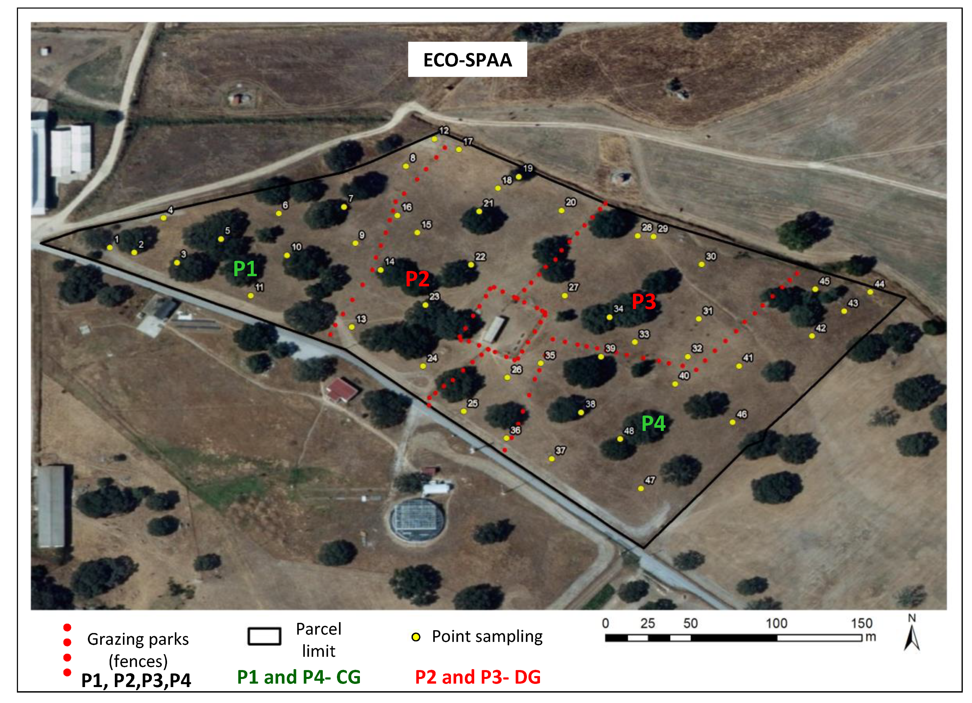
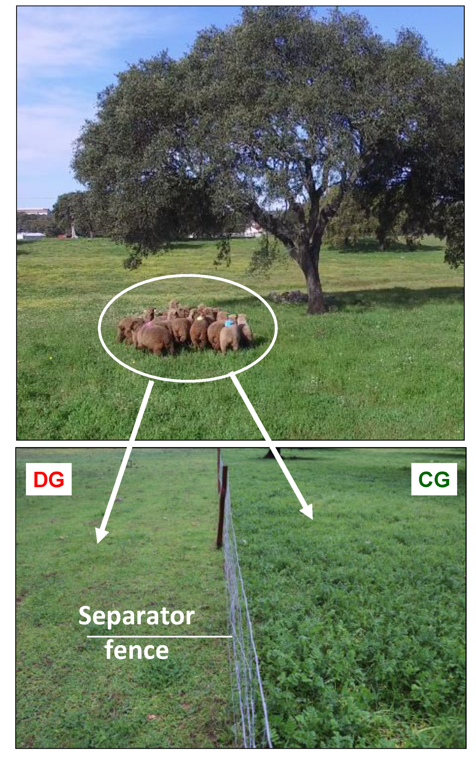
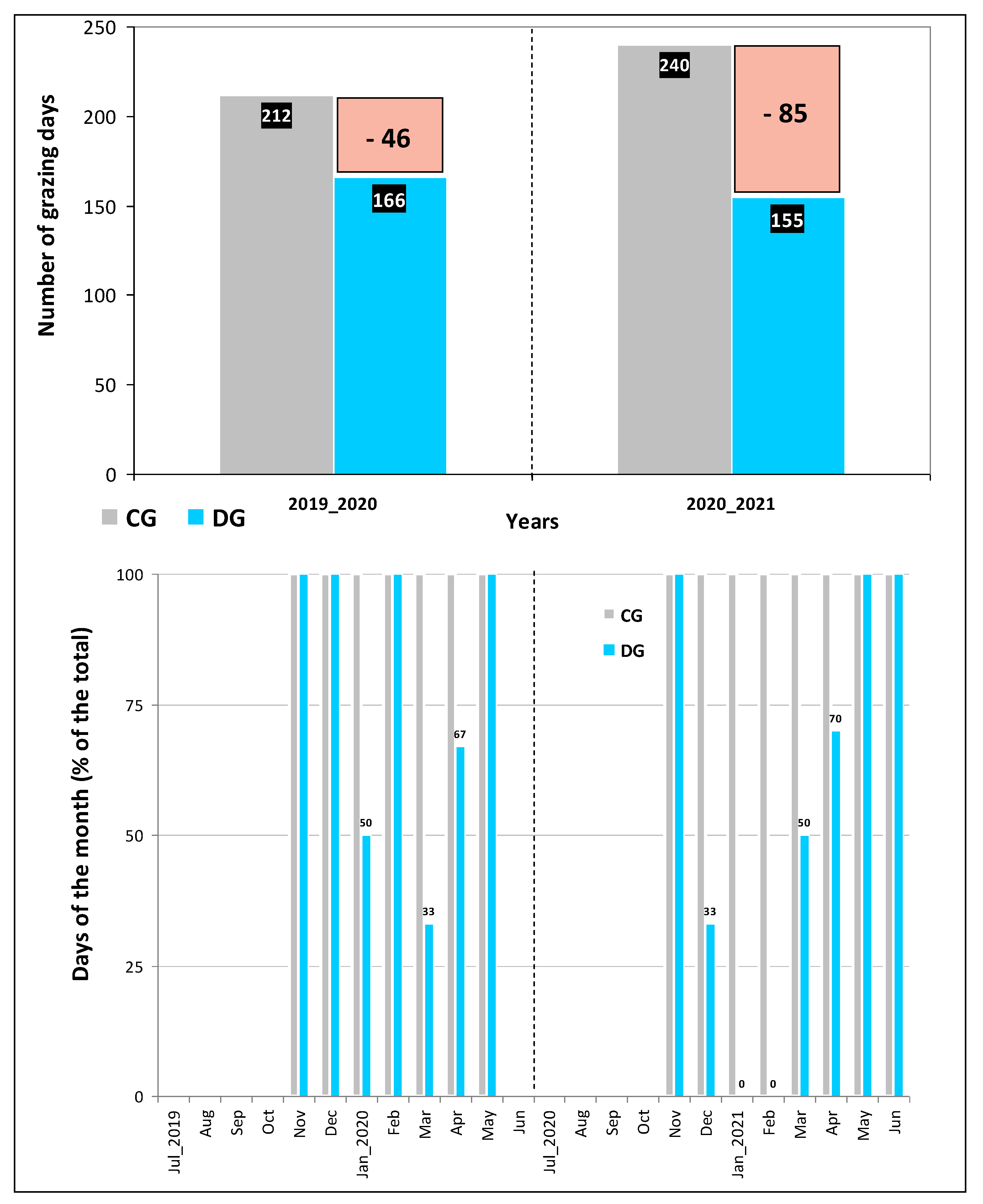
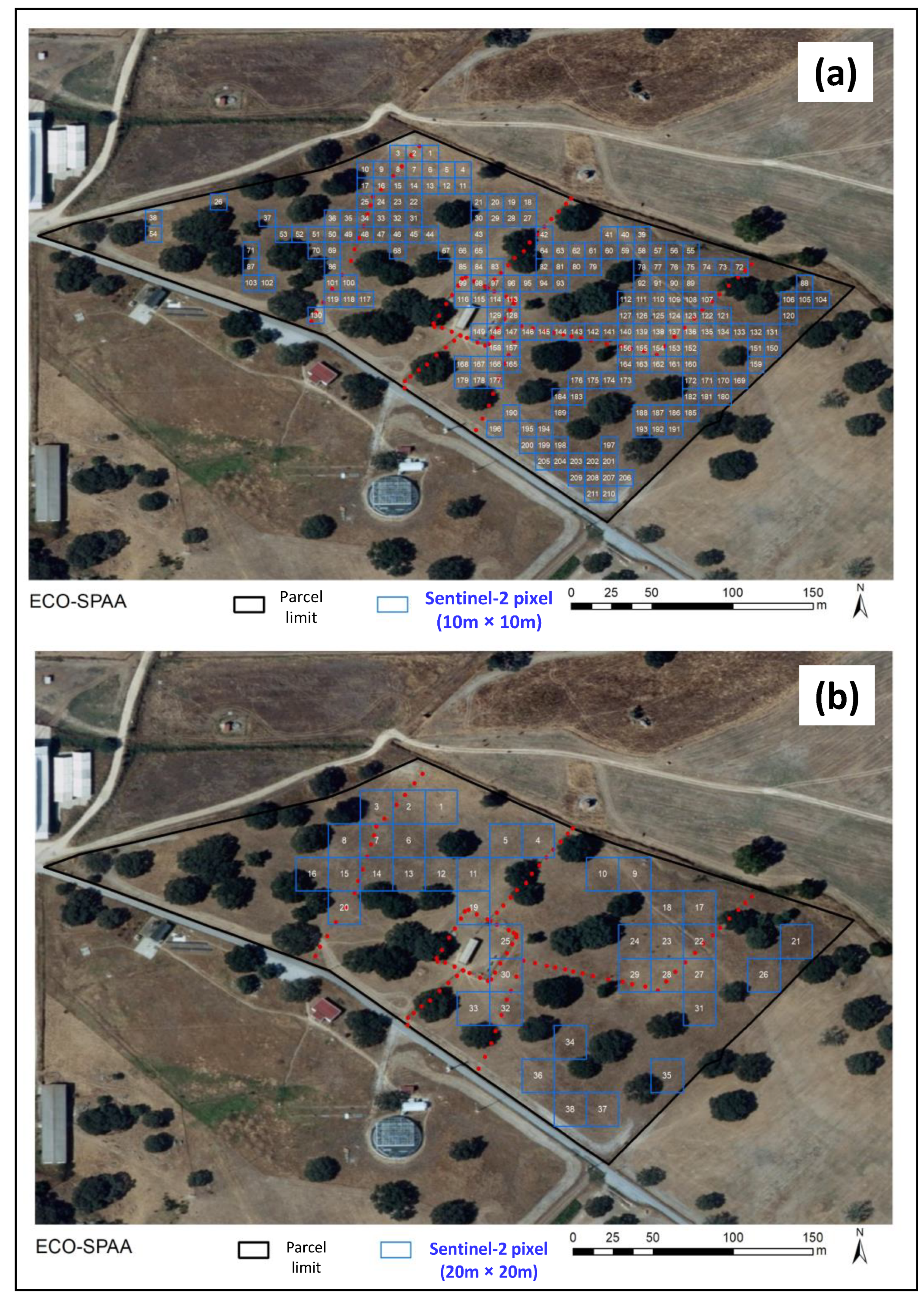
2.1. Experimental Site Description and Grazing Management

This research was conducted at an experimental pasture called Eco-SPAA which is located in the Mitra farm (38°53.10 N; 8°01.10 W), of University of Évora, in Southern Portugal. The area of study was 4 ha. An overview of the experimental field is given in Figure 1. The study was performed between September 2019 and June 2021.
This pasture was subdivided with fences in 2019, as part of a study to evaluate different grazing systems [7], into four parks (P1 to P4), each with an area of approximately 1 hectare. In parks P1 and P4, a continuous grazing system was implemented (CG; stocking rate of 1 UA throughout the whole vegetative cycle of the pasture), while in parks P2 and P3 a deferred grazing system was implemented, and with a higher stocking rate (DG; stocking rate of 2 UA; they entered or left the grazing parks according to the average height of the pasture, left when this was less than 5 cm, and re-entered when this was greater than 10 cm) [7]. A buffer park outside the experimental pasture receives the animals during the grazing rest periods of parks P2 and P3 (DG treatment). To determine the average height of the pasture in each of the 4 grazing parks (P1 to P4), 12 sampling points were geo-referenced from a total of 48 sampling areas (Figure 1). The detail of the separator fence between the two grazing systems under study (CG and DG) and the respective pasture development are presented in Figure 2. The total number of grazing days that animals spent in each treatment (grazing system) in each year (2019/2020 and 2020/2021) is shown in Figure 3. The number of days between years was different because the life cycles of the pastures were different. After all, the onset of autumn rains was different between years. The number of days spent in each treatment is also described across months, highlighting the relationships between the pastures’ growth rates and their intake rate.
In this area, the soil can be classified as a Cambisol derived from granite [21]. Usually, these acid soils are utilized for grazing and forest land or mixed with arable farming [21]. In this specific case, this pasture was used in extensive sheep grazing systems for over three decades. It integrates the Montado ecosystem, with biodiverse permanent dryland pastures under Holm oak trees (Quercus ilex ssp. rotundifolia Lam.) with a low density (about 8–10 trees.ha−1). From a textural classification, the soil has a sandy loam texture (mean clay content = 9.3 ± 1.3%); acid (mean pH = 5.4 ± 0.2); rich in potassium (mean = 150.4 ± 51.6 mg kg−1); medium CEC (11.4 ± 2.7 cmol.kg−1) and ECa (12.4 ± 4.4 mS.m−1), low levels of organic matter (mean = 1.6 ± 0.6%), and phosphorus (mean = 55.6 ± 21.5 mg kg−1) [22].

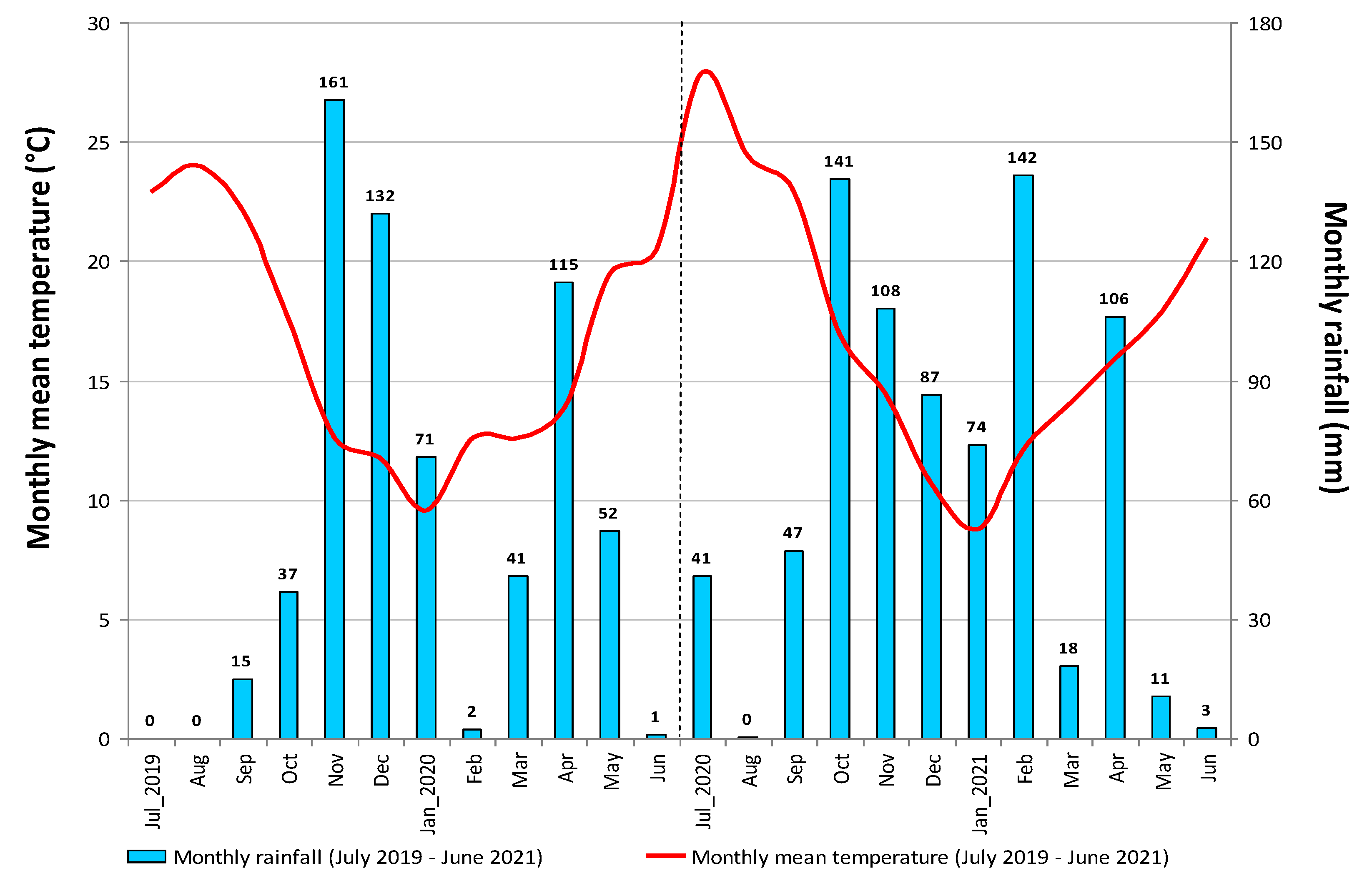
2.2. Characterisation of the Climate

The climate of the area where the experimental field was located is Mediterranean. It can be classified as Csa (Köppen–Geiger classification; [23]). High inter-annual irregularity and low rainfall (usually <600 mm), mainly in the autumn–winter seasons and practically expressionless during the summer [8].
The evolution of the monthly mean temperature and rainfall between July 2019 and June 2021 are presented in Figure 4. The above-mentioned inter-annual irregularity is very clear: while 2019/2020 recorded a total accumulated rainfall of 627 mm, close to what is common in the region and evenly distributed over the autumn, winter, and spring seasons (213, 205, and 208 mm, respectively), 2020/2021 was a relatively rainy year, with total accumulated precipitation of 778 mm evenly distributed over the autumn and winter (approximately 300 mm in each season), but with low rainfall in spring (total of 135 mm) and abnormal rainfall events in summer. Flooding and the consequent increase in soil compaction by animal trampling are usual due to the rainfall irregularity, particularly the high concentration of rainfall during some events, which is associated with the poor drainage of these soils [8].

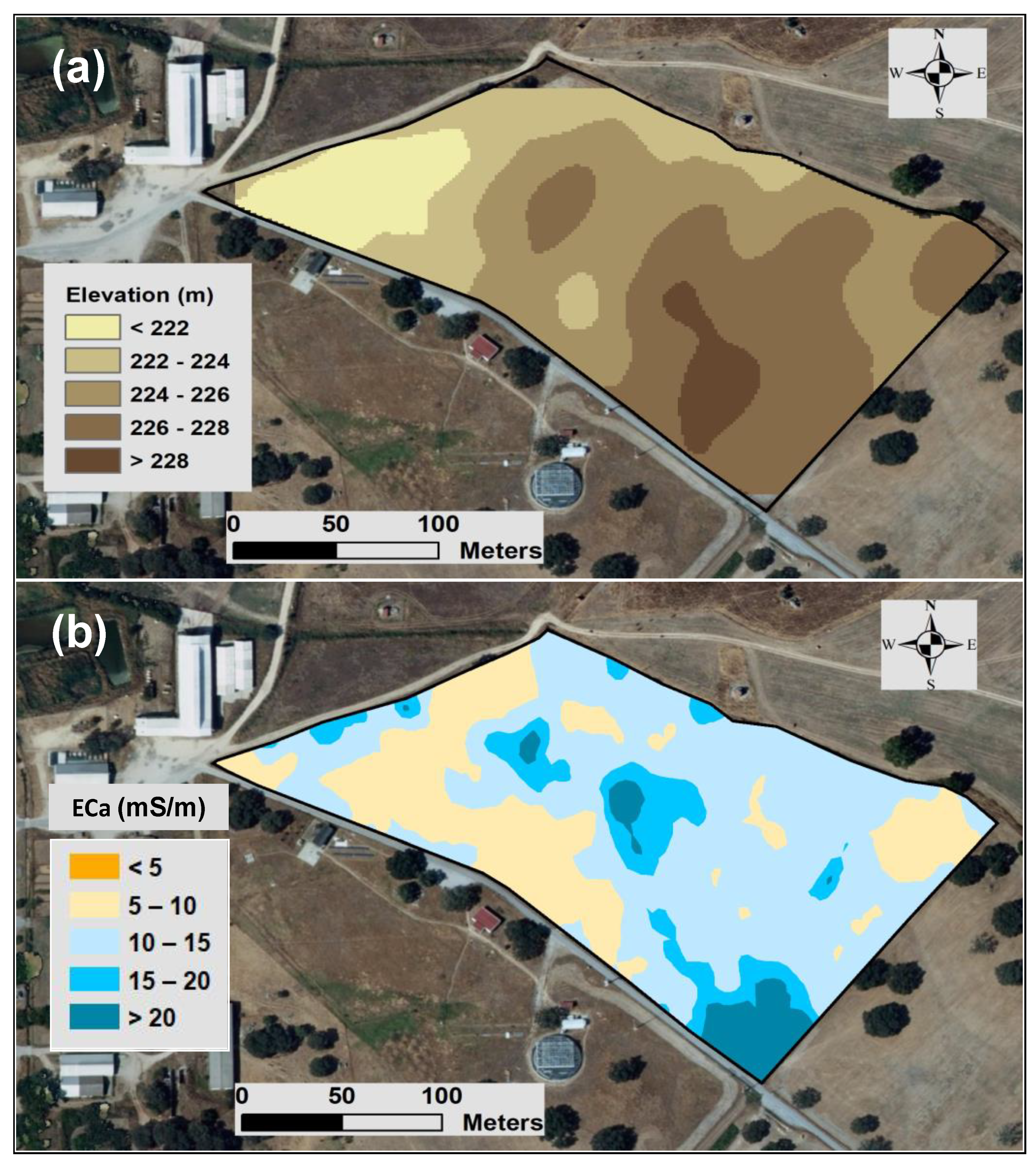
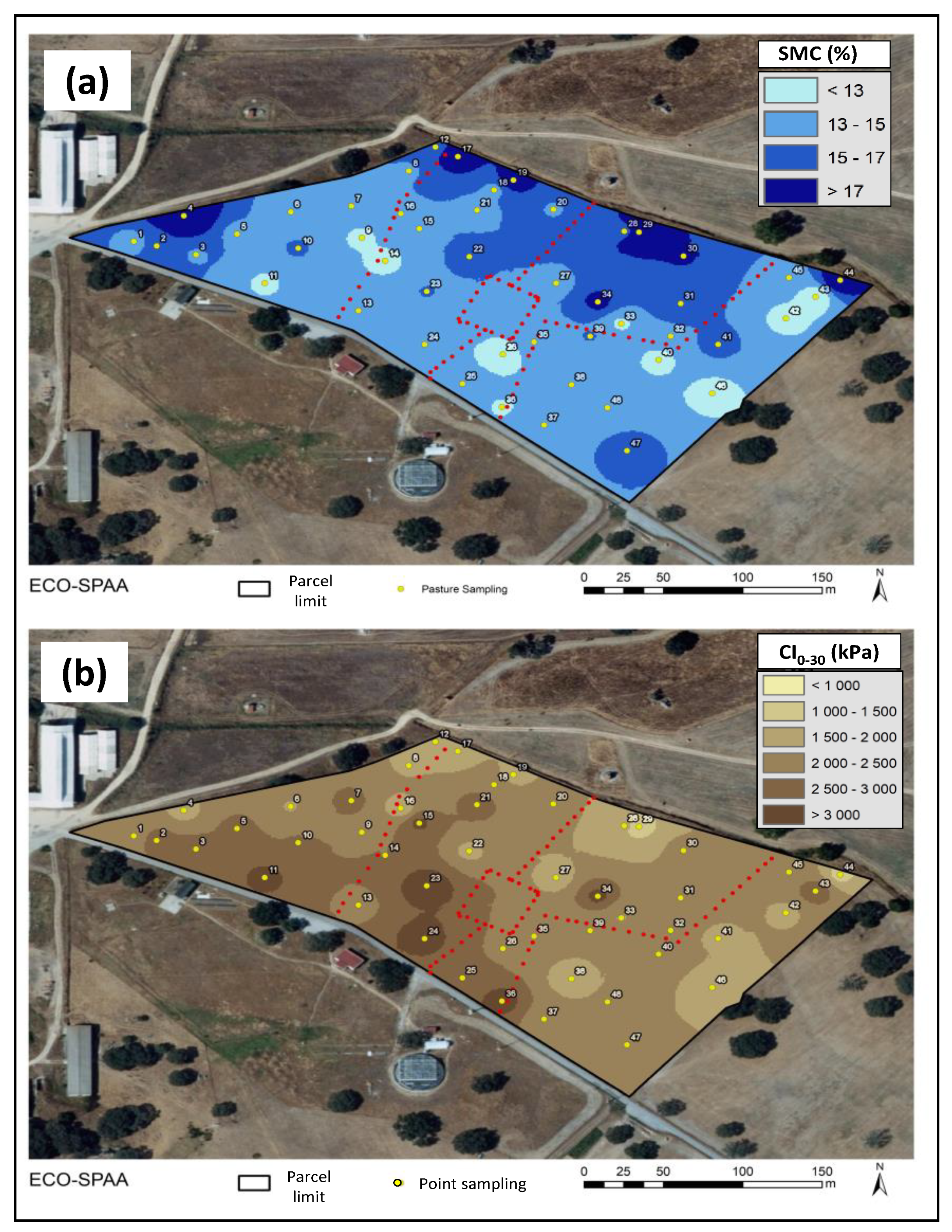
2.3. Soil Apparent Electrical Conductivity (ECa) and Altimetric Surveys

To characterize the soil spatial variability of the experimental pasture, a soil apparent electrical conductivity (ECa) survey was carried out in October 2019. Topsoil data (0–37.5 cm) obtained by an “EM38” device (Geonics Ltd., Mississauga, ON, Canada) were used. A metal-free sledge was used to mount the ECa sensor, and it was pulled behind an all-terrain vehicle equipped with a GNSS receiver. Thus, a topographic survey was also provided.

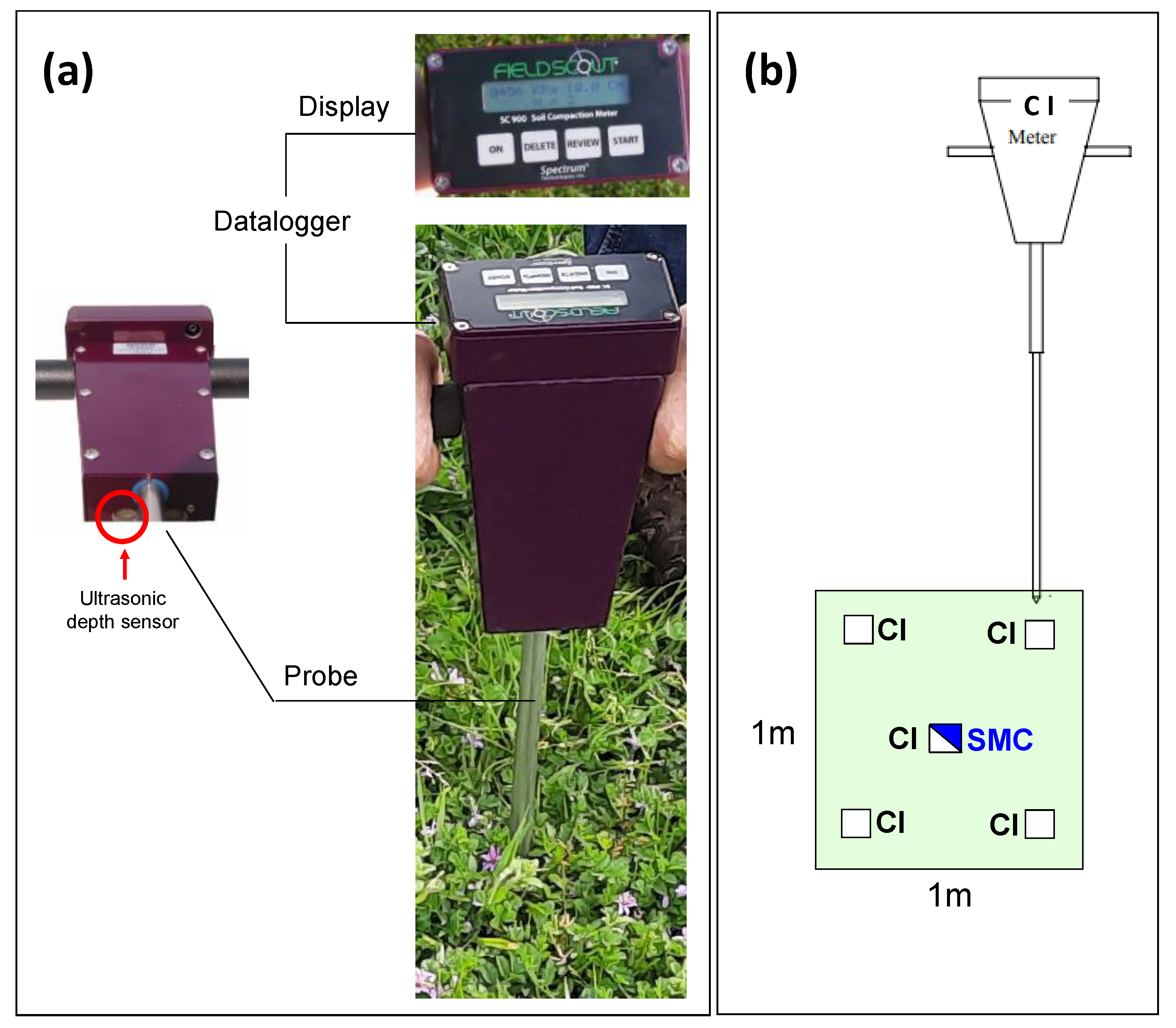
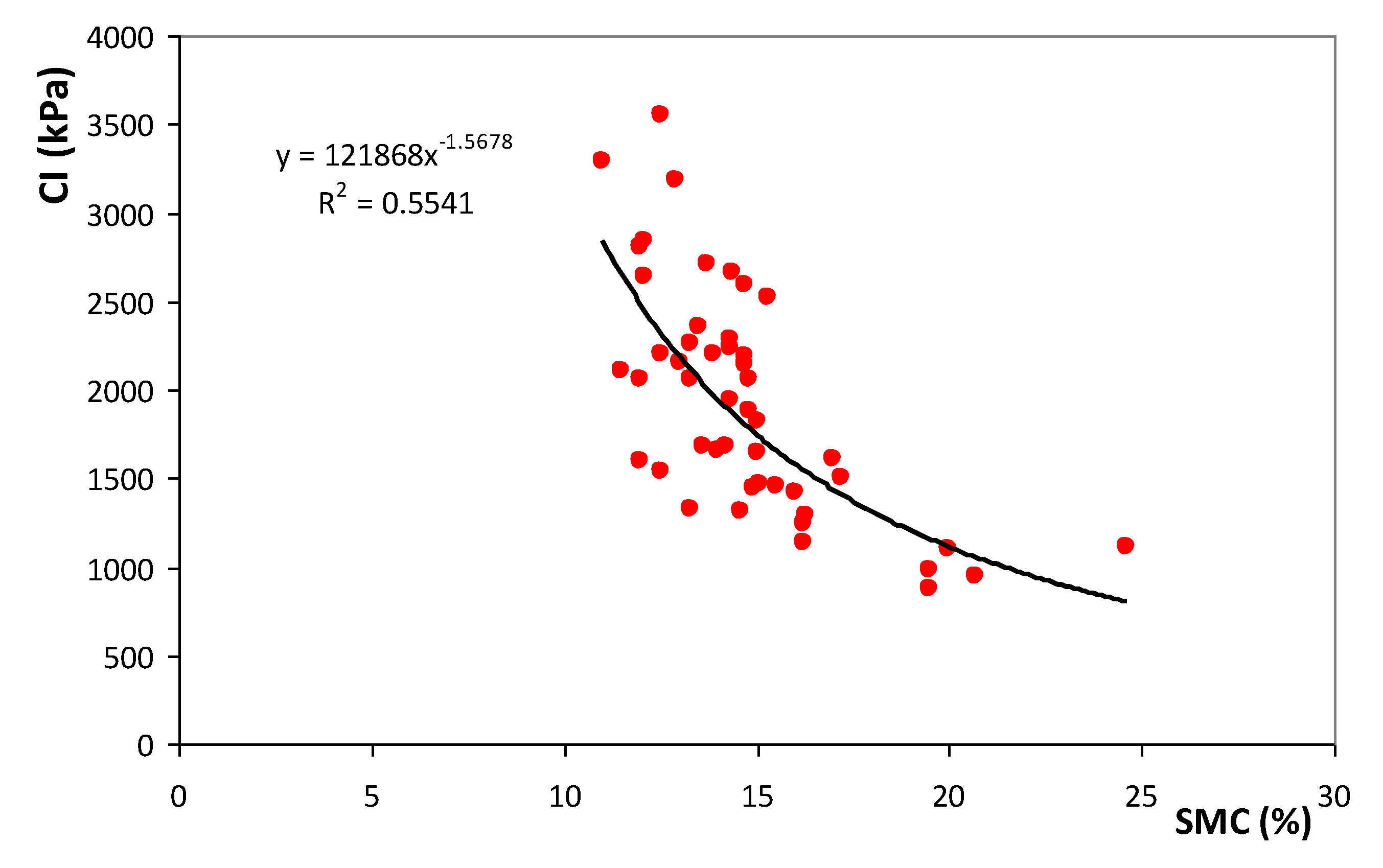
2.4. Cone Index and Soil Moisture Measurements

With the aim of measuring the soil resistance to penetration (Cone Index, CI, in kPa), an electronic cone penetrometer “FieldScout SC 900” (Figure 5a) (Spectrum Technologies, Aurora, IL, USA) equipped with an ultrasonic depth sensor was used in October 2021. In each of the 48 sampling areas of 1 m2, five CI measurements were performed between 0 and 45 cm (maximum depth allowed by the device). These measurements were conducted with this pattern: one in the central point of the sampling location, and one in each of its four quadrants (Figure 5b). The same operator performed the measurements to avoid errors from the uncertainty of maintaining a constant penetration rate [8]. After the field measurements, data were processed: (i) outliers were removed with a preliminary analysis; (ii) the mean CI value of the set of five measurements were computed for each sampling location and each depth (0–10, 10–20, 20–30 and 0–30 cm); (iii) the graphic representation of CI as a function of soil depth was generated. Readings for all treatments were taken on the same day to avoid soil moisture variability, which can affect the resistance measurements. A gouge auger and a hammer were used to collect soil samples from the 0–30 cm soil layer with the aim of characterizing the soil moisture content (SMC) at the time of CI measurement in the central point of each measurement area (Figure 5b). Soil samples were weighed and dried at 70 °C for 48 h; then they were weighed again to establish the SMC [8].

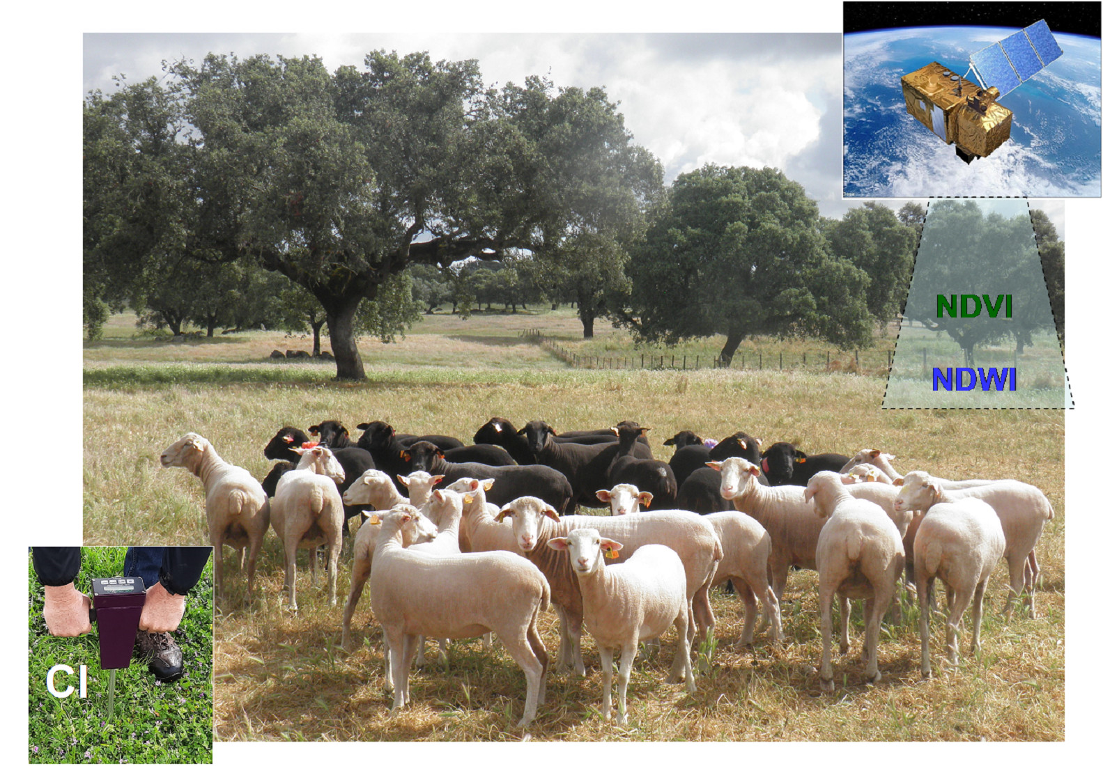
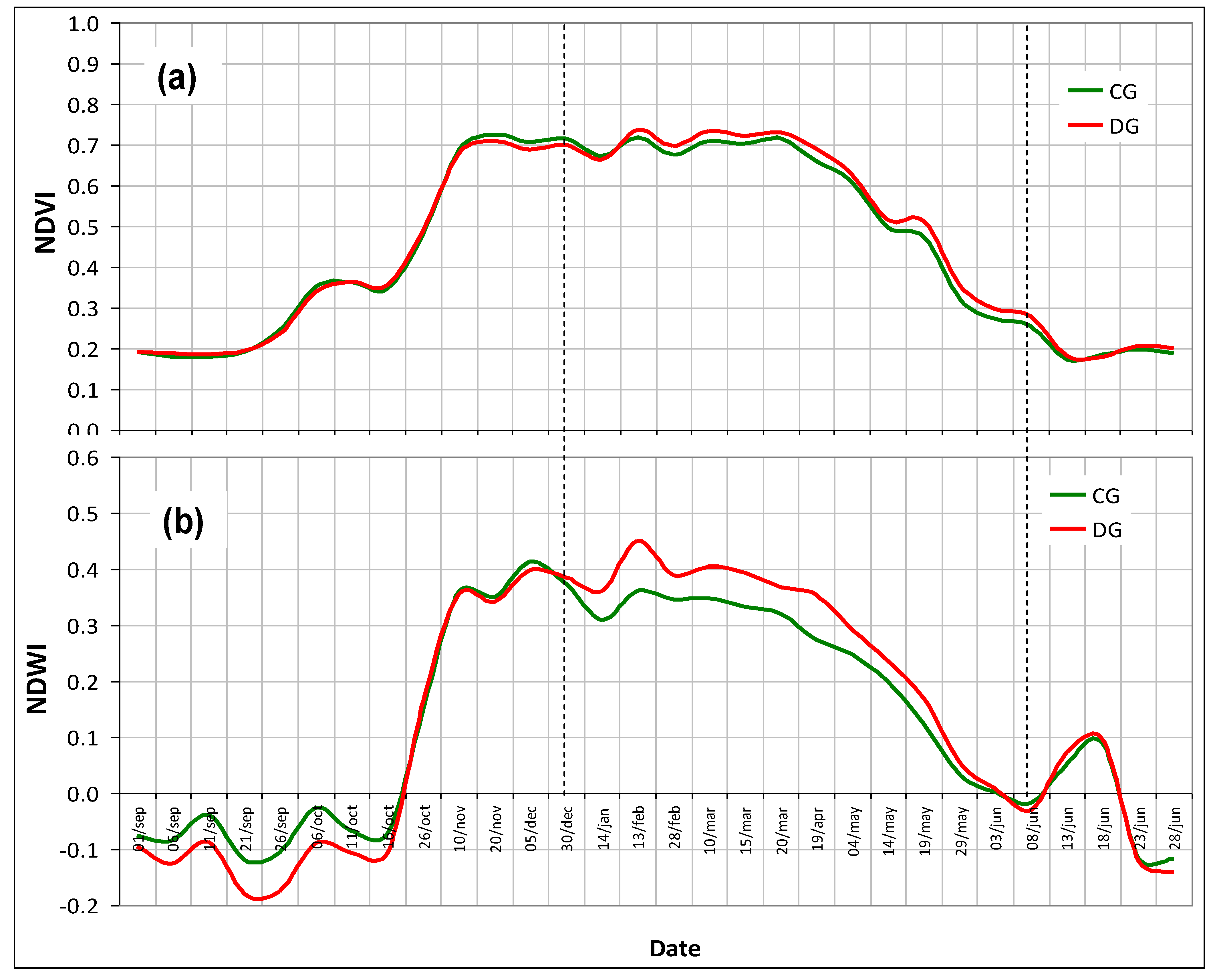
2.5. Vegetation Multispectral Measurement: NDVI and NDWI Time Series Reconstruction

From the Copernicus data hub, a multi-temporal Sentinel-2 imagery dataset (between 1 September 2020 and 30 June 2021), free of clouds and atmospherically corrected, was downloaded. Band 8 (B8; near infrared, NIR; 842 nm) and band 4 (B4; RED; 665 nm), both with a 10 m spatial resolution, were utilized to compute the satellite normalized difference vegetation index (NDVI = (B8 − B4)/(B8 + B4)) and for the reconstruction of the mean NDVI trends (NDVI time series records). Band 8A (B8A; NIR; 865 nm) and band 11 (B11; short-wave infrared, SWIR; 1610 nm), both with a 20 m spatial resolution, were utilized to compute the satellite normalized difference water index (NDWI = (B8A − B11)/(B8A + B11)) and for the reconstruction of the mean NDWI trends (NDWI time series records).
The calculation of the mean values of these indices took into account, for each grazing park, the set of values of the “10 m × 10 m” Sentinel-2 pixel sampling areas for NDVI (Figure 6a), and the “20 m × 20 m” Sentinel-2 pixel sampling areas for NDWI (Figure 6b).

2.6. Statistical Analysis

A descriptive statistical analysis was conducted for CI. Inferential analysis consisted of: (i) regression analysis between SMC and CI to 0–30 cm data (with a 95% significance level); and (ii) analysis of variance (ANOVA) between treatments (CG versus DG) and between CI depths (0–10, 10–20, 20–30 and 0–30 cm). The IBM SPSS Statistics package for Windows (version 28.0, IBM Corp., Armonk, NY, USA) was used to perform these analyses.
With the aim of analysing the mean separation whenever the variables presented significant differences in the ANOVA (p < 0.05), multiple comparisons were conducted using the Tukey’s HSD test.
The maps of soil variables (SMC, ECa, and CI) and the altimetric map were produced through geostatistical analyses with the “Geostatistical Analyst” extension of ArcGIS software (version 10.5, ESRI, Inc., Redlands, CA, USA). Kriged maps were generated using the ArcMap module of ArcGIS.

3. Results

The elevation map (Figure 7a) is representative of the undulating topography characteristic of the region, which is known to have an impact on the spatial variability of soil parameters. This soil spatial variability is also evident in the ECa map (Figure 7b): although as well as the preponderance of areas with intermediate values (10–15 mS.m−1), there are also representative areas with low ECa (<10 mS.m−1) and areas with high ECa (>15 mS.m−1).
The cone index (mean, standard deviation, and range) for different depths in each treatment (CG versus DG) is presented in Table 1. Although average CI values tend to be higher in areas with DG (Figure 8a) at all depths (Figure 8b), the differences obtained are not statistically significant (p = 0.337). The ANOVA showed CI significant differences (p = 0.000) between depths, with higher CI values at 10–20 cm depth (p = 0.000) compared to 0–10 cm depth, and 20–30 cm depth (p = 0.000) compared to 0–10 cm depth. The multiple comparisons showed no significant differences (p = 0.949) between 10–20 cm and 20–30 cm depths. These multiple comparisons also showed no significant differences (p = 0.891) for interactions between treatments and depths.
The maps of SMC (a) and CI (b) at 0–30 cm depth are presented in Figure 9. The spatial patterns of these two parameters are relatively opposite, with higher CI values in areas with lower SMC content. This inverse relationship between CI and SMC is evident in Figure 10. The spatial pattern of CI at different depths is presented in Figure 11.
The pattern of NDVI (a) and NDWI (b) time series (CG versus DG) over the pasture vegetative cycle of the 2020/2021 (between 1 September 2020 and 30 June 2021) indicates a trend of higher vegetative vigour (higher NDVI and higher NDWI) in areas under DG (relative to areas under CG) between the beginning of January and the end of May 2021 (Figure 12).

4. Discussion

It is known that increased stocking rates have negative effects on soil properties and are positively correlated with animal trampling [15]. Donkor et al. [24] suggested that DG systems have associated greater CI than CG systems. Recent studies [8,10] have sought to assess the impact of different cattle management approaches on CI. It is known that sheep have a much lower individual impact on soil compaction than cattle (based in the ratio between the body weight and the soil contact area) [25]; however, this specie has a very marked gregarious behaviour [2], therefore, this pilot study aims to assess the impact that two grazing management strategies (CG versus DG) on soil penetration resistance (CI) as result of sheep trampling. The practical question is: which situation has a greater impact on soil compaction, (i) low stocking rates (few animals) in permanent grazing (CG) or (ii) high stocking rates (many animals) in intermittent grazing with periods, of variable duration, of recovery, i.e., temporary livestock exclusion (DG).
Several works have shown the strong spatial variability of topsoil characteristics in Montado areas in general [26,27], and, in particular, in the pasture used in this study (Mitra farm), either through direct and exhaustive soil sampling [19], and/or by the use of expedient tools, usually based on ECa surveys with contact sensors [28] or electromagnetic induction sensors [29]. The CI tool has been widely used by researchers and service providers because it is easily used in the field [30], allowing farmer’s decision support to adopt sustainable grazing management [28].
This spatial variability is the first condition for differentiated management implementation, a fundamental step in the intensification of forage-based livestock systems [19], characteristic of the Mediterranean region of southern Portugal [2]. Spatial variability reflects the effect of several factors, mainly such as edaphic, climatic and management [2]. Among the edaphic factors, the nature of the original rocks and, consequently, the texture [18], has the potential to identify and predict spatial variability of soil compaction. In this study, predominate coarse-textured soils, typically less susceptible to compaction than silt loam soils [10,30], which demonstrates the interest, in the future, in extending these exploratory studies to other soil types.
The spatial variability in the CI found in this study (CV of 22 to 41%; Table 1) combined with the variability in the soil profile (depths of 0–10; 10–20; 20–30; and 0–30 cm; Figure 8), are similar to those found in a study with cows, in a nearby plot and with very similar characteristics [8]. The scale of magnitude of these CVs shows that the measurement of CI value is influenced by the management system, in addition to the soil intrinsic factors (e.g., soil structure, texture, and moisture) [29].
Although average CI values tend to be higher in areas with DG (Figure 8a) at all depths (Figure 8b), as indicated by the study of Donkor et al. [24], the differences obtained are not statistically significant. These findings are a positive signal in terms of soil conservation and sustainability from the perspective of potential intensification of forage-based livestock systems. These results, that correspond to two years (2019/2020 and 2020/2021), suggest that this could be a dynamic process, with recovery cycles [8], where physical and biological restorative processes may mitigate near surface soil impacts [10,12]. In future works, longer term monitoring of changes in soil penetration resistance may be required [10].
The multiple comparisons showed significant differences (p = 0.000) in CI values between depths, with lower CI values at 0–10 cm depth compared to the other two soil layers considered (10–20 or 20–30 cm). This pattern is different from that registered in other study of animal trampling for the same soil type but carried out with cattle grazing [8], where the highest compaction was recorded in the 10-20 cm soil layer. In this same study, livestock trampling effect was significant at a depth of 0-10 cm. In general, studies report that the highest animal trampling impact occurs at the topsoil layer [10,12,24,25,26,30,31,32,33]: 0–5 cm according to Debiasi et al. [31] and Roesh et al. [25], 0-10 cm according to Sharrow [12], and 0–15 or 0–20 cm according to Donkor et al. [24], Nawaz et al. [30] and Mayerfeld et al. [10]. The CI pattern registered in this study justifies replicating this study of trampling monitoring in other soil types.
Another result of this study confirms the significant and inverse relationship between CI and SMC (R2 = 0.55): the exponential increase in the CI with the decrease in SMC content, or vice-versa [32]. This pattern, attributed to the lubricating effect of SMC on cone penetration [33] and to the reduction in the cohesive forces between soil clay particles [34], was registered in several works [8,32,33].
The prospect of intensifying extensive forage-based livestock through the adoption of dynamic grazing systems should take into consideration the long-term impact on soil compaction and, mainly, the system’s productivity indicators. One of the criteria used in the comparison and evaluation of grazing systems is the development and vegetative vigour of the pasture. Time series of RS indices (Sentinel-2 imagery), such as NDVI and NDWI [35], can address this goal because they are sensitive to changes in the vegetation cover before and after grazing and can be efficient tools to determine the response pattern of pasture [20]. The typical pattern of these indices throughout the vegetative cycle of the pastures (Figure 12) reflects the effect of temperature and precipitation [34]. In this study, a trend of higher vegetative vigour (higher NDVI and higher NDWI) was observed in areas under DG (relative to areas under CG), between the beginning of January and the end of May 2021 (Figure 12). This vegetative response shows that DG livestock systems, with appropriate sheep stocking rates and recovery periods, despite causing small changes to soil penetration resistance (CI), are unlikely to negatively impact plant growth, aspect also highlighted by Mayerfeld et al. [10] and Ma et al. [36].
These results show that soil physical parameters, namely soil compaction, and pasture response relationships are needed to provide improved practical tools for farmers [11]. These tools are particularly important to enhance the ability to make informed and economically viable decisions for management options [11]. An approach that uses monitoring tools to support decisions in complex and dynamic systems exposed to changing conditions, as is the case of the Montado ecosystem, should be used in the future to guide and aid farmers’ decision-making process [3]. Although statistically not significant, the systematic tendency observed at all depths evaluated in this study towards greater CI in plots subjected to DG, suggests that future works of longer duration to evaluate compaction/recovery cycles, should also consider the trend towards increased intensification of extensive livestock production, based on electric and mobile fences, with a stocking rates of up to three times higher than in CG systems (approximately 1 UA, per hectare, corresponding to approximately 6–7 sheep.ha−1).
Since sheep exhibit highly selective grazing, CG is said to be responsible for degradation of vegetation and soils and declines in productivity and biodiversity [37,38]. In contrast, DG can be used as a tool to improve pasture resilience, livestock performance, pasture quality and profitability at a farm scale, when considering a typical spring surplus [36,39]. Dynamic grazing systems, that combine DG with flexible stocking rate based on changing rainfall conditions, are fundamental for achieving sustainable outcomes [36,38]. Nevertheless, long term studies are required [37] to quantify responses of different pasture types in variable climatic scenarios and, mainly, whole-farm analysis to integrate the multiple impacts of DG on the farm system, which include the positive impacts on the pasture performance after the deferred period, and the negative impact on pasture growth and nutritive value during the deferred period [39]. These studies should also include the measurement of parameters indicating change in ecosystem function, resilience, and ecological services [36,38].
Recent studies show the potential of the Montado to provide a range of ecosystem services. Guimarães et al. [40] go further and propose a results-based model implemented under Common Agricultural Policy and based on specific environmental results, namely, a healthy and functional soil ecosystem and a biodiverse native Mediterranean pasture. For example, soil degradation is identified as an important problem in the Montado, where animal grazing activity impacts soil health and its productivity through trampling [40]. It is in this framework that expedient technologies such as the electronic cone penetrometer, the soil electrical conductivity meter, satellite imagery and others will become indispensable monitoring tools for the quantification of payments to farmers and for the follow-up by public authorities and policy makers.

5. Conclusions

Compared to continuous grazing (CG), deferred grazing (DG) consists in adapting the number of animals and the number of days grazed to the availability of pasture and represents a more dynamic, intensive, and productive strategy for grazing management. The impact of sheep trampling on soil compaction, associated with different grazing systems, is a complex and little-studied process and could become an important tendency indicator of soil sustainability. This reflects the balance between restorative and compactive mechanisms on grazed and ungrazed areas.
The results of soil resistance measurements (CI) in this study showed no significant differences between CG and DG in all depths evaluated (0–10, 10–20, and 20–30 cm). At the same time, there was no negative impact on vegetative response, measured by vegetation indices obtained by RS (NDVI and NDWI). These findings are encouraging not only from the perspective of sustainability, but also reveal good prospects for the intensification of extensive forage-based livestock systems.
In future works, decision support tools should evaluate the long-term impact on soil compaction of grazing management systems with appropriate sheep stocking rates and recovery periods and should consider at the same time the system’s productivity indicators.

Author Contributions

Conceptualization, J.S.; methodology, J.S., E.C., S.S., M.d.C., J.M.d.S., L.L.P., F.M., and A.P.; software, J.S., L.L.P., F.M., and J.M.d.S.; validation, J.S.; formal analysis, J.S. and L.L.P.; investigation, J.S., E.C. and A.P.; resources, J.S. and A.P.; data curation, J.S.; writing—original draft preparation, J.S.; writing—review and editing, J.S. and S.S.; visualization, J.S.; supervision, J.S.; project administration, J.S. and A.P.; funding acquisition, J.S. and A.P. All authors have read and agreed to the published version of the manuscript.

Funding

This work was funded by National Funds through the FCT (Foundation for Science and Technology) under the Project UIDB/05183/2020.

Data Availability Statement

Not applicable.

Conflicts of Interest

The authors declare no conflict of interest.

References

  1. Psyllos, G.; Hadjigeorgiou, I.; Dimitrakopoulos, P.G.; Kizos, T. Grazing land productivity, floral diversity, and management in a semi-arid Mediterranean landscape. Sustainability 2022, 14, 4623. [Google Scholar] [CrossRef]
  2. Efe Serrano, J. Pastures in Alentejo: Technical Basis for Characterization, Grazing and Improvement; Universidade de Évora—ICAM: Évora, Portugal, 2006; pp. 165–178. (In Portuguese) [Google Scholar]
  3. Jaurena, M.; Durante, M.; Devincenzi, T.; Savian, J.V.; Bendersky, D.; Moojen, F.G.; Pereira, M.; Soca, P.; Quadros, F.L.F.; Pizzio, R.; et al. Native grasslands at the core: A new paradigm of intensification for the campos of Southern South America to increase economic and environmental sustainability. Front. Sustain. Food Syst. 2021, 5, 547834. [Google Scholar] [CrossRef]
  4. Bégué, A.; Arvor, D.; Bellon, B.; Betbeder, J.; De Abelleyra, D.; Ferraz, R.; Lebourgeois, V.; Lelong, C.; Simões, M.; Verón, S.R. Remote sensing and cropping practices: A review. Remote Sens. 2018, 10, 99. [Google Scholar] [CrossRef]
  5. Ferreira, P.M.A.; Andrade, B.O.; Podgaiski, L.R.; Dias, A.C.; Pillar, V.D.; Overbeck, G.E.; Mendonça, M.S., Jr.; Boldrini, I.I. Long-term ecological research in southern Brazil grasslands: Effects of grazing exclusion and deferred grazing on plant and arthropod communities. PLoS ONE 2020, 15, e0227706. [Google Scholar] [CrossRef]
  6. Tozer, K.N.; Muller, K.; Craven, T.; Tarbotton, I.; Coster, A.; Burke, R.; Sherlock, J.; Cameron, C. Effect of deferred grazing during late spring and summer on pasture productivity in Waikato and Bay of Plenty hill country. J. N. Z. Grassl. 2020, 82, 111–119. [Google Scholar] [CrossRef]
  7. Carreira, E.; Serrano, J.; Gomes, C.J.P.; Shahidian, S.; Paniagua, L.L.; Pilirito, A.; Castro, J.; Carvalho, M.; Pereira, A.F. Effect of sheep grazing, stocking rates and dolomitic limestone application on the floristic composition of a permanent dryland pasture, in the montado agroforestry system of Southern Portugal. Animals 2022, 12, 2506. [Google Scholar] [CrossRef]
  8. Serrano, J.; Marques, J.; Shahidian, S.; Carreira, E.; Marques da Silva, J.; Paixão, L.; Paniagua, L.L.; Moral, F.; Ferraz de Oliveira, I.; Sales-Baptista, E. Sensing and mapping the effects of cow trampling on the soil compaction of the montado Mediterranean ecosystem. Sensors 2023, 23, 888. [Google Scholar] [CrossRef]
  9. Reichert, J.M.; Suzuki, L.E.; Reinert, D.J. Compactação do solo em sistemas agropecuários e florestais: Identificação, efeitos, limites críticos e mitigação. Tópicos Ci. Solo 2007, 5, 49–134. (In Portuguese) [Google Scholar]
  10. Mayerfeld, D.; Kruger, E.; Gildersleeve, R.; Rickenbach, M. Impacts of different grazing approaches on woodland ecosystem properties. Agrofor. Syst. 2022, 96, 527–540. [Google Scholar] [CrossRef]
  11. Drewry, J.J.; Cameron, K.C.; Buchan, G.D. Pasture yield and soil physical property responses to soil compaction from treading and grazing—A review. Aust. J. Soil Res. 2008, 46, 237–256. [Google Scholar] [CrossRef]
  12. Sharrow, S. Soil compaction by grazing livestock in silvopastures as evidenced by changes in soil physical properties. Agrofor. Syst. 2007, 71, 215–223. [Google Scholar] [CrossRef]
  13. Jordon, M.W. Does mixed vs separate sheep and cattle grazing reduce soil compaction? Soil Use Manag. 2021, 37, 822–831. [Google Scholar] [CrossRef]
  14. Medina, M.C. Effects of soil compaction by trampling of animals in soil productivity. Remediations. Rev. Colomb. Cienc. Anim. 2016, 8, 88–93. [Google Scholar] [CrossRef]
  15. Teague, R.; Proenza, F.; Norton, B.; Steffens, T.; Barnes, M.; Kothmann, M.; Roath, R. Benefits of multi-paddock grazing management on rangelands: Limitations of experimental grazing research and knowledge gaps. In Grassland Ecology, Management and Restoration; Schroder, H.G., Ed.; Nova Science Publishers, Inc.: Hauppauge, NY, USA, 2008; Cap. 1; pp. 41–80. [Google Scholar]
  16. Devantier, B.P.; Stevens, D.R.; Rennie, G.M.; Tozer, K.N. The effect of deferred grazing in spring and early summer pastures on pasture growth rate and feed quality. J. N. Z. Grassl. 2017, 79, 189–196. [Google Scholar] [CrossRef]
  17. Gao, T.; Yang, X.C.; Jin, Y.X.; Ma, H.L.; Li, J.Y.; Yu, H.D.; Yu, Q.Y.; Xiao, Z.; Xu, B. Spatio-temporal variation in vegetation biomass and its relationships with climate factors in the Xilingol grasslands, Northern China. PLoS ONE 2013, 8, e83824. [Google Scholar] [CrossRef]
  18. Pentos, K.; Pieczarka, K.; Serwata, K. The relationship between soil electrical parameters and compaction of sandy clay loam soil. Agriculture 2021, 11, 114. [Google Scholar] [CrossRef]
  19. Serrano, J.; Shahidian, S.; Costa, F.; Carreira, E.; Pereira, A.; Carvalho, M. Can soil pH correction reduce the animal supplementation needs in the critical autumn period in Mediterranean Montado ecosystem? Agronomy 2021, 11, 514. [Google Scholar] [CrossRef]
  20. Batista, P.; Almeida, G.; Silva, J.; Pandorfi, H.; Silva, M.; Silva, R.; Melo, M.; Lins, F.; Junior, J. Short-term grazing and its impacts on soil and pasture degradation. Rev. DYNA 2020, 87, 123–128. [Google Scholar] [CrossRef]
  21. FAO. World Reference Base for Soil Resources; Food and Agriculture Organization of the United Nations, World Soil Resources Reports N 103; FAO: Rome, Italy, 2006. [Google Scholar]
  22. Serrano, J.; Shahidian, S.; Marques da Silva, J.; Sales-Baptista, E.; Ferraz de Oliveira, I.; Lopes de Castro, J.; Pereira, A.; Cancela de Abreu, M.; Machado, E.; Carvalho, M. Tree influence on soil and pasture: Contribution of proximal sensing to pasture productivity and quality estimation in montado ecosystems. Int. J. Remote Sens. 2018, 39, 4801–4829. [Google Scholar] [CrossRef]
  23. Peel, M.C.; Finlayson, B.L.; McMahon, T.A. Updated world map of the Köppen-Geiger climate classification. Hydrol. Earth Syst. Sci. 2007, 11, 1633–1644. [Google Scholar] [CrossRef]
  24. Donkor, N.T.; Gedir, J.V.; Hudson, R.J.; Bork, E.W.; Chanasyk, D.S.; Naeth, M.A. Impacts of grazing systems on soil compaction and pasture production in Alberta. Can. J. Soil Sci. 2002, 82, 1–8. [Google Scholar] [CrossRef]
  25. Roesch, A.; Weisskopf, P.; Oberholzer, H.; Valsangiacomo, A.; Nemecek, T. An approach for describing the effects of grazing on soil quality in life-cycle assessment. Sustainability 2019, 11, 4870. [Google Scholar] [CrossRef]
  26. Benavides, R.; Douglas, G.B.; Osoro, K. Silvopastoralism in New Zealand: Review of effects of evergreen and deciduous trees on pasture dynamics. Agrofor. Syst. 2009, 76, 327–350. [Google Scholar] [CrossRef]
  27. McCormick, S.; Jordan, C.; Bailey, J. Within and between-field spatial variation in soil phosphorus in permanent grassland. Prec. Agric. 2009, 10, 262–276. [Google Scholar] [CrossRef]
  28. Moral, F.J.; Serrano, J.M. Using low-cost geophysical survey to map soil properties and delineate management zones on grazed permanent pastures. Prec. Agric. 2019, 20, 1000–1014. [Google Scholar] [CrossRef]
  29. Pias, O.H.C.; Cherubin, M.R.; Basso, C.J.; Santi, A.L.; Molin, J.P.; Bayer, C. Soil penetration resistance mapping quality: Effect of the number of subsamples. Acta Sci. 2018, 40, e34989. [Google Scholar] [CrossRef]
  30. Nawaz, M.F.; Bourrié, G.; Trolard, F. Soil compaction impact and modelling. A review. Agron. Sustain. Dev. 2013, 33, 291–309. [Google Scholar] [CrossRef]
  31. Debiasi, H.; Franchini, J.C.; Junior, A.A.B.; Oliveira, F.A. Variabilidade espacial e temporal da resistência do solo à penetração após diferentes pressões de pastejo no Norte do Paraná. In Agricultura de Precisão: Resultados de um Novo Olhar; Bernardi, A., Naime, J., Resende, Á., Inamasu, R.B.e.R., Eds.; Embrapa: Brasília, Brasil, 2014; Cap. 53; pp. 507–512. (In Portuguese) [Google Scholar]
  32. Moraes, M.T.; Silva, V.; Zwirtes, A.; Carlesso, R. Use of penetrometers in agriculture: A review. Eng. Agríc. 2014, 34, 179–193. [Google Scholar] [CrossRef]
  33. Duarte, T.F.; Silva, T.J.A.; Bonfim-Silva, E.M.; Fenner, W. Resistance of a Red Latosol to penetration: Comparison of penetrometers, model adjustment, and soil water content correction. Eng. Agr. Jaboticabal 2020, 40, 462–472. [Google Scholar] [CrossRef]
  34. Kostic, M.; Raijovik, M.; Ljubicic, N.; Ivosevic, M.; Radulovic, M.; Blagojevic, D.; Dedovic, N. Georeferenced tractor wheel slip data for prediction of spatial variability in soil physical properties. Prec. Agric. 2021, 22, 1659–1684. [Google Scholar] [CrossRef]
  35. Serrano, J.; Shahidian, S.; Marques da Silva, J. Evaluation of normalized difference water index as a tool for monitoring pasture seasonal and inter-annual variability in a Mediterranean agro-silvo-pastoral system. Water 2019, 11, 62. [Google Scholar] [CrossRef]
  36. Ma, L.; Yuan, F.; Liang, H.; Rong, Y. The effects of grazing management strategies on the vegetation, diet quality, intake and performance of free grazing sheep. Livest. Sci. 2014, 161, 185–192. [Google Scholar] [CrossRef]
  37. Glindemann, T.; Wang, C.; Tas, B.M.; Schiborra, A.; Gierus, M.; Taube, F.; Susenbeth, A. Impact of grazing intensity on herbage intake, composition, and digestibility and on live weight gain of sheep on the Inner Mongolian steppe. Livest. Sci. 2009, 124, 142–147. [Google Scholar] [CrossRef]
  38. Wang, T.; Teague, W.R.; Park, S.C. Evaluation of continuous and multipaddock grazing on vegetation and livestock performance—A modelling approach. Rangel. Ecol. Manag. 2016, 69, 457–464. [Google Scholar] [CrossRef]
  39. Tozer, K.N.; Howarth, S.M.; Sherlock, J.; Tarbotto, I.S. Impact of Deferred Grazing on Profitability of a Hill Country Farm in North-western Waikato. In Proceedings of the Resilient Pastures Symposium, Lake Karapiro, New Zealand, 11–12 May 2021; Grassland Research and Practice Series. New Zealand Grassland Association: Dunedin, New Zealand, 2021; Volume 17, pp. 393–400. [Google Scholar]
  40. Guimarães, M.H.; Pinto-Correia, T.; Costa Freitas, M.B.; Ferraz-de-Oliveira, I.; Sales-Baptista, E.; Ferragolo da Veiga, J.F.; Tiago Marques, J.; Pinto-Cruz, C.; Godinho, C.; Belo, A.D.F. Farming for nature in the Montado: The application of ecosystem services in a results-based model. Ecosyst. Serv. 2023, 61, 101524. [Google Scholar] [CrossRef]
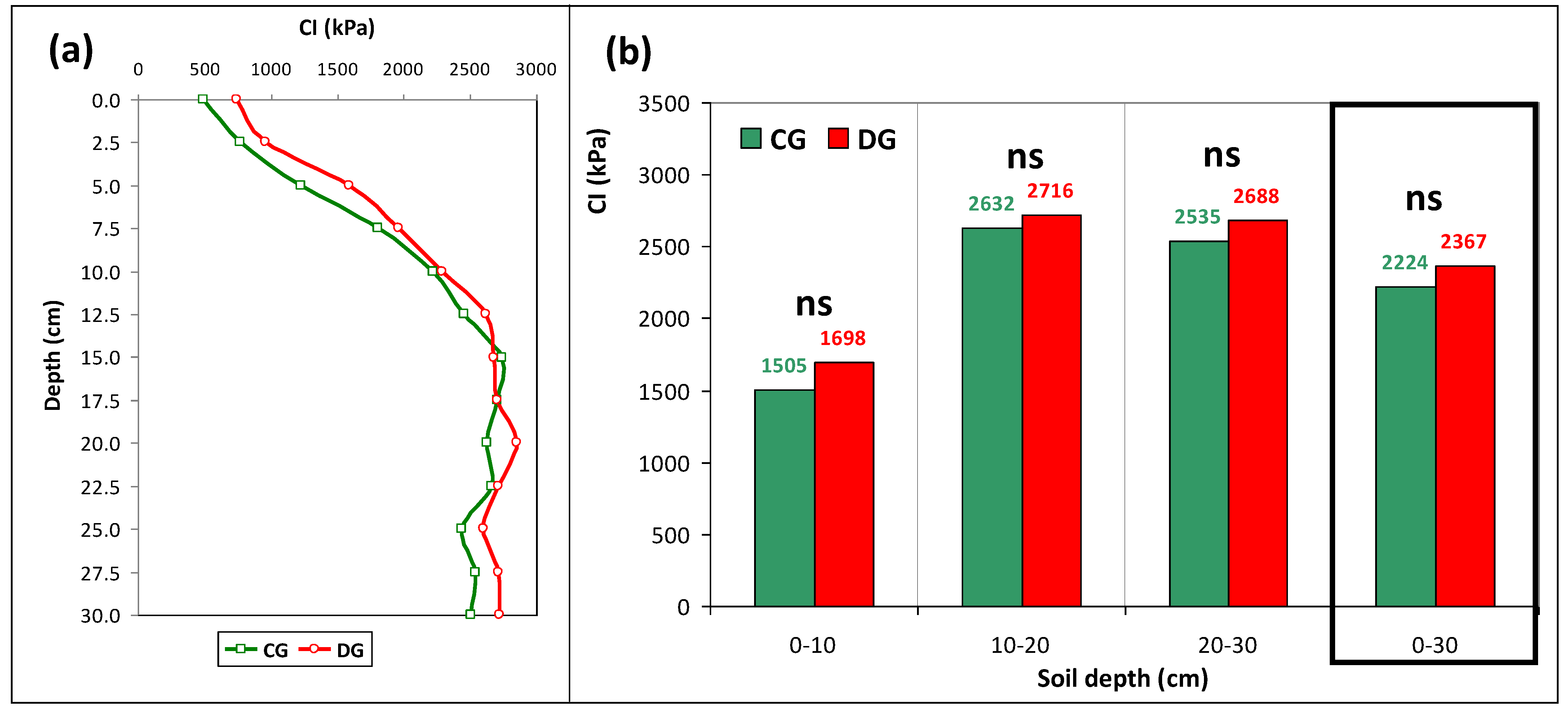
Figure 1. Experimental pasture “Eco-SPAA”, located at Mitra farm.
Agriengineering 05 00047 g001
Figure 2. Detail of the separator fence between the two grazing systems under study.
Agriengineering 05 00047 g002
Figure 3. Number of grazing days in each treatment in 2019/2020 and 2020/2021.
Agriengineering 05 00047 g003
Figure 4. Thermo-pluviometric diagram of Meteorological Station of Mitra (Évora, Portugal) between July 2019 and June 2021.
Agriengineering 05 00047 g004
Figure 5. “FieldScout SC 900” cone penetrometer (a) and schematic representation of Cone Index (CI) and Soil Moisture Content (SMC) sampling area (b).
Agriengineering 05 00047 g005
Figure 6. Sentinel-2 pixel sampling areas of the experimental pasture: (a) “10 m × 10 m” pixels; (b) “20 m × 20 m” pixels.
Agriengineering 05 00047 g006
Figure 7. Elevation map (a) and soil apparent electrical conductivity (ECa) map (b) of the experimental pasture.
Agriengineering 05 00047 g007
Figure 8. Average cone index (CI, in kPa) for continuous (CG) versus deferred grazing (CG) at: (a) 0–30 cm soil depth; (b) 0–10 cm, 10–20 cm, 20–30 cm and 0–30 cm soil depths. “ns”—Not significant.
Agriengineering 05 00047 g008
Figure 9. Soil moisture content (SMC) map (a) and cone index (CI) map (b) at 0–30 cm depth.
Agriengineering 05 00047 g009
Figure 10. Relationship between soil moisture content (SMC) and mean cone index (CI) in the 0–30 cm soil layer.
Agriengineering 05 00047 g010
Figure 11. Cone index maps at different depths: (a) 0–10 cm; (b) 10–20 cm; (c) 20–30 cm.
Agriengineering 05 00047 g011
Figure 12. Sentinel-2 time series: (a) normalized difference vegetation index (NDVI); and (b) normalized difference water index (NDWI), between 1 September 2020 and 30 June 2021.
Agriengineering 05 00047 g012
Table 1. Mean, standard deviation (SD) and range of cone index (CI, in kPa) for different depths in each treatment (continuous grazing, CG versus deferred grazing, DG).
DepthCGDG
(cm)Mean ± SDRangeMean ± SDRange
0–10 1501 ± 617500–34501696 ± 624837–2795
10–20 2619 ± 6551334–35362664 ± 8941078–4200
20–30 2520 ± 893802–45192656 ± 8861483–4511
0–30 2194 ± 4841303–32142338 ± 6391250–3597
Disclaimer/Publisher’s Note: The statements, opinions and data contained in all publications are solely those of the individual author(s) and contributor(s) and not of MDPI and/or the editor(s). MDPI and/or the editor(s) disclaim responsibility for any injury to people or property resulting from any ideas, methods, instructions or products referred to in the content.

