1. Introduction
The concept of historic districts first appeared in The Athens Charter. Buildings and districts of historical value shall be appropriately preserved and shall not be destroyed [
1], distilling buildings and districts of historical value into a single category. The concept of historic districts was introduced in The Washington Charter, which defined them as cities, towns, historical centers, and residential areas, regardless of their size, and also their natural and manufactured environments [
2]. The introduction of this concept extended the original concept of buildings and districts of historical value to include the environments in which they are located. Historic districts refer to areas where the architectural heritage is more concentrated or where the traditional style and local characteristics of a certain period are better reflected intact. However, with the accelerating urbanization, many cities with traditional historic districts are undergoing large-scale urban renewal. Although the physical environment of historic districts has been improved, the spatial form of historic districts has been severely damaged by massive demolition and construction [
3]. Historic districts are still trapped in a situation of insufficient spatial group vitality, lack of spatial quality, and lack of regional culture. Many of them lack daily activities for residents to maintain vitality and meet the growing social needs [
4]. Historic districts are facing the problem of balancing development and conservation [
5]. In order to retain urban diversity and vitality, historic districts with diverse roles and appropriate scales must be preserved [
6,
7] but also for preserving traditional urban culture.
China State Council published the initial administrative document on urban planning in February 2016. The document highlights the need for orderly urban restoration and organic renewal, addressing issues with environmental quality degradation, spatial disorder, and the destruction of historical and cultural heritage in old cities, restoring the functions and vitality of old cities, better preserving the historical heritage, and presenting the urban landscape [
8]. The historic quarter is, without a doubt, the source of the city’s life. The historic district keeps the artifacts’ vibrant real-life history and true historical knowledge intact. It has a certain size that may accurately capture the special qualities of a particular historical era, a particular nationality, or a particular location. It serves as a vehicle for preserving the city’s historical culture and displaying the urban environment. In the environment of urban renewal, it is inevitable to explore and analyze its spatial form to find a targeted conservation strategy. The urban form depends on the interaction between people and urban public space, and the intertwined processes of people’s activities and places of residence make urban life more diverse and dynamic [
6,
9]. The Venice Charter promotes the original conservation of the historic spatial environment [
10]. Urban space can be defined as a perception revealed by the urban fabric [
11,
12,
13], a social and cultural phenomenon that shapes the relationship between people and the environment [
14]. This scene forms a way of daily life, capable of meeting people’s needs [
15]. In particular, street networks are a long-term component of the urban form [
16,
17,
18,
19] and are an essential driver in the urbanization process [
20], with street layout identified as a significant factor influencing pedestrian movement in cities [
21,
22,
23,
24]. Data-based urban morphology attempts to model spatial data to track urban morphology, spatial order, configuration, and orientation, and one approach is the space syntax.
Understanding urban space in its physical, morphological, and social components is made possible by the space syntax [
25,
26,
27], providing a different approach that focuses on topological aspects of urban morphology to estimate the supportiveness of the built environment. The space syntax initially focused on city pedestrian movement [
22,
28]; however, further research discovered a strong correlation between topological measures and social engagement [
29,
30,
31]. This circumstance can clarify the connection between spatial shape and human behavior in the environment [
27]. The Sishengci historic district has a long history, and it is crucial to study the spatial form of the historic district to conserve the spatial form of architectural heritage. In order to solve the problem of social integration of the residents in the historic district and to maintain the sustainable organic vitality of the district, this study is a methodological exploration of conservation and renewal in the Sishengci historic district, uses the space syntax of the axial lines analysis method, discusses the analysis of the historic district and its development law from a rational point of view, quantifies the interpretation of the spatial form of the historic district, and proposes the strategy of conservation and renewal of the historic district here to meet the social integration of the residents.
2. Methodology
2.1. Research Area
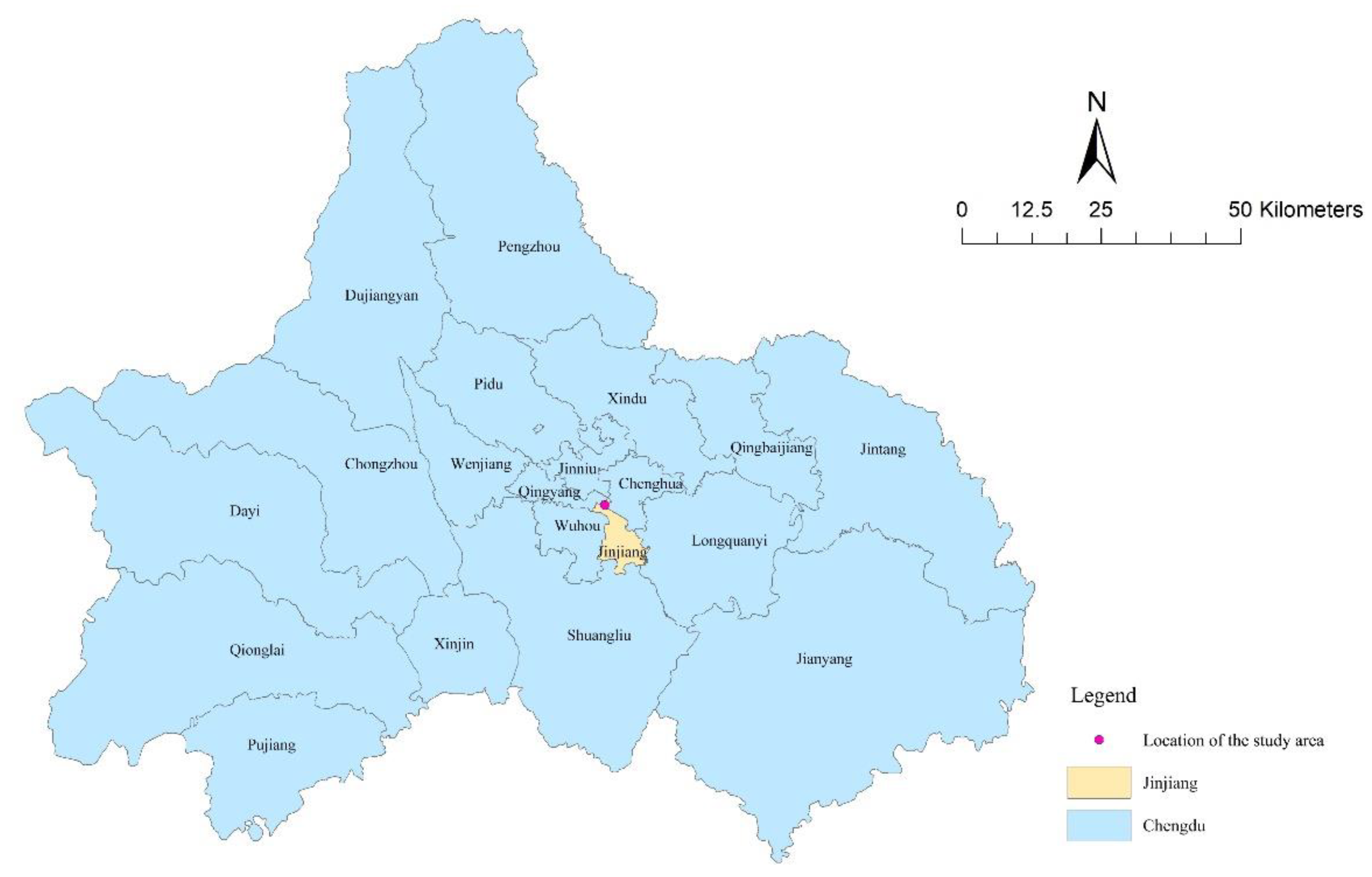
The Sishengci historic district is located in Jinjiang District, Chengdu, China (
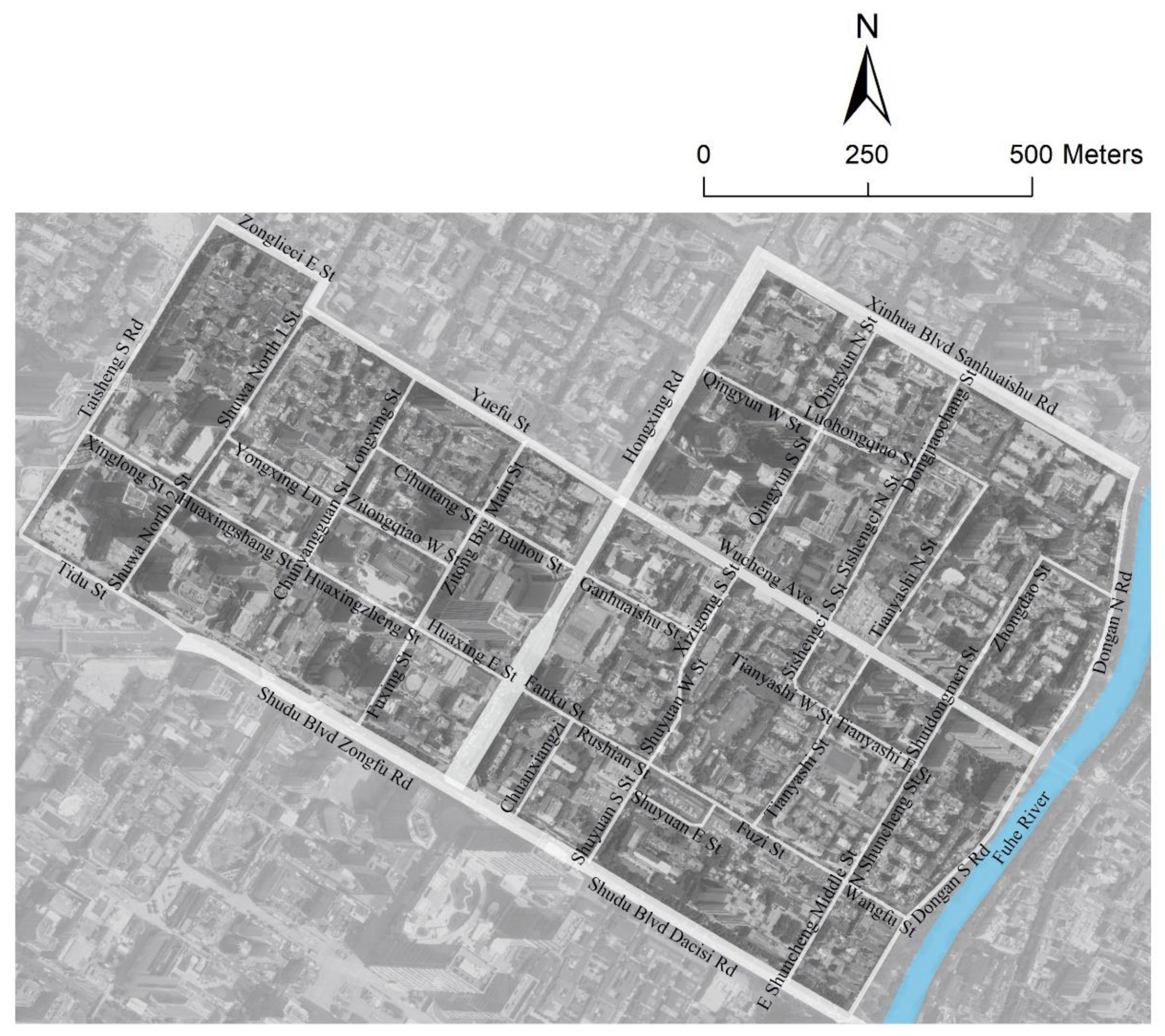
Figure 1), and the district extends from Xinhua Boulevard and Yuefu Street in the north, to Shudu Avenue in the south, to Taisheng South Road and Hongxing Road in the west, and to Dongan North Road and Dongan South Road in the east (
Figure 2). The Sishengci historic district is strategically located, with a deep historical and cultural heritage and many indigenous inhabitants. As a Chinese historical and cultural district, it still preserves the intact architectural style of the Republic of China era. The existing buildings are mainly western-style buildings and residential buildings with western Sichuan structures.
The Sishengci historic district basically follows the road structure of the traditional streets and alleys of Chengdu, forming a complete urban node as early as the Republic of China era. After going through the round-trip process of reconstruction, destruction, and reconstruction again in different eras, the district’s buildings have also survived the construction characteristics of each period.
2.2. Space Syntax and Syntactic Variables
Human perception of spatial systems is always dependent on small-scale space, and the integration of local information creates an understanding of the whole, according to the perspective of spatial perception. Therefore, understanding large-scale space begins with comprehending small-scale space. In spatial studies based on space syntax, it is presumable that the street network divides the large-scale urban spatial system into multiple identifiable small-scale core components. Axial lines analysis is the dividing technique that is most frequently employed. The dividing method that is most frequently used is axial lines analysis. In this study, we choose axial lines analysis, where the generated morphological variables are used by space syntax to quantitatively characterize the space, and axial maps are used to examine the spatial morphological structure [
27]. The following section lists the main morphological variables.
2.2.1. Connectivity
The number of spaces in the system that are connected to space
is indicated by the connectivity value [
32]. In the map of the axial lines, transportation networks are abstracted as interconnected axial lines, which correlate spatial systems. The more an axial line is connected to other axial lines, the better the spatial accessibility and the higher the value of connectivity, as shown in the formula:
where
is the number of spaces that are connected to space
,
;
is the total number of spaces in the system;
is the connectivity value of space
.
2.2.2. Control
The control value refers to the relative degree of control of space
over the spaces intersecting it [
27], and the control value reveals the relationship between adjacent spaces in the system, as shown in the formula:
where
is the control value of space
, space
is the space connected with space
, and
is the connectivity value of space
,
.
2.2.3. Depth
Depth is the minimum number of spaces traveled to reach a destination [
27] and expresses the accessibility of the axial nodes in the system in a topological sense. The sum of the depths of each other space in the system determines a space’s overall depth. The mean depth, which is the average distance from space
to all other spaces, reflects how simple it is to access the designed space in the system [
27]. This is an essential measure of the accessibility of an area, as shown in the formula:
where
is the shortest distance between space
to space
,
denotes the total depth value of space
, and
is the mean depth value of space
.
2.2.4. Integration
Integration shows how space
is connected to other spaces and their surroundings, considering the earliest lines and the systematic distances between all points of the system [
33] and real relative asymmetry (RRA) is the opposite of integration. RRA eliminates the effects of the spatial structure itself and the spatial structure based on the mean depth. The formula is as follows:
where
represents the integration measure’s standardized value and
denotes the RRA value of space
.
3. Results
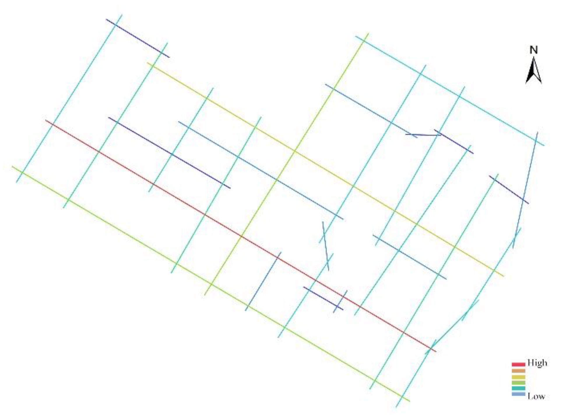
Firstly, the basic information about the Sishengci historic district was collected, and the axial lines map of the Sishengci historic district was drawn through the space with the longest and least axial lines according to the relationship between the streets. DepthmapX was used to calculate the axial lines, quantify the relationship between each street space, and analyze them with the field survey. When the axial lines are analyzed, each has different colors and represents different parameter values. Warm colors represent larger parameter values, and cool colors represent smaller parameter values, and the darker the warm color is, the larger the parameter value it represents. The darker the cool color is, the smaller the parameter value it represents.
3.1. Integration Analysis
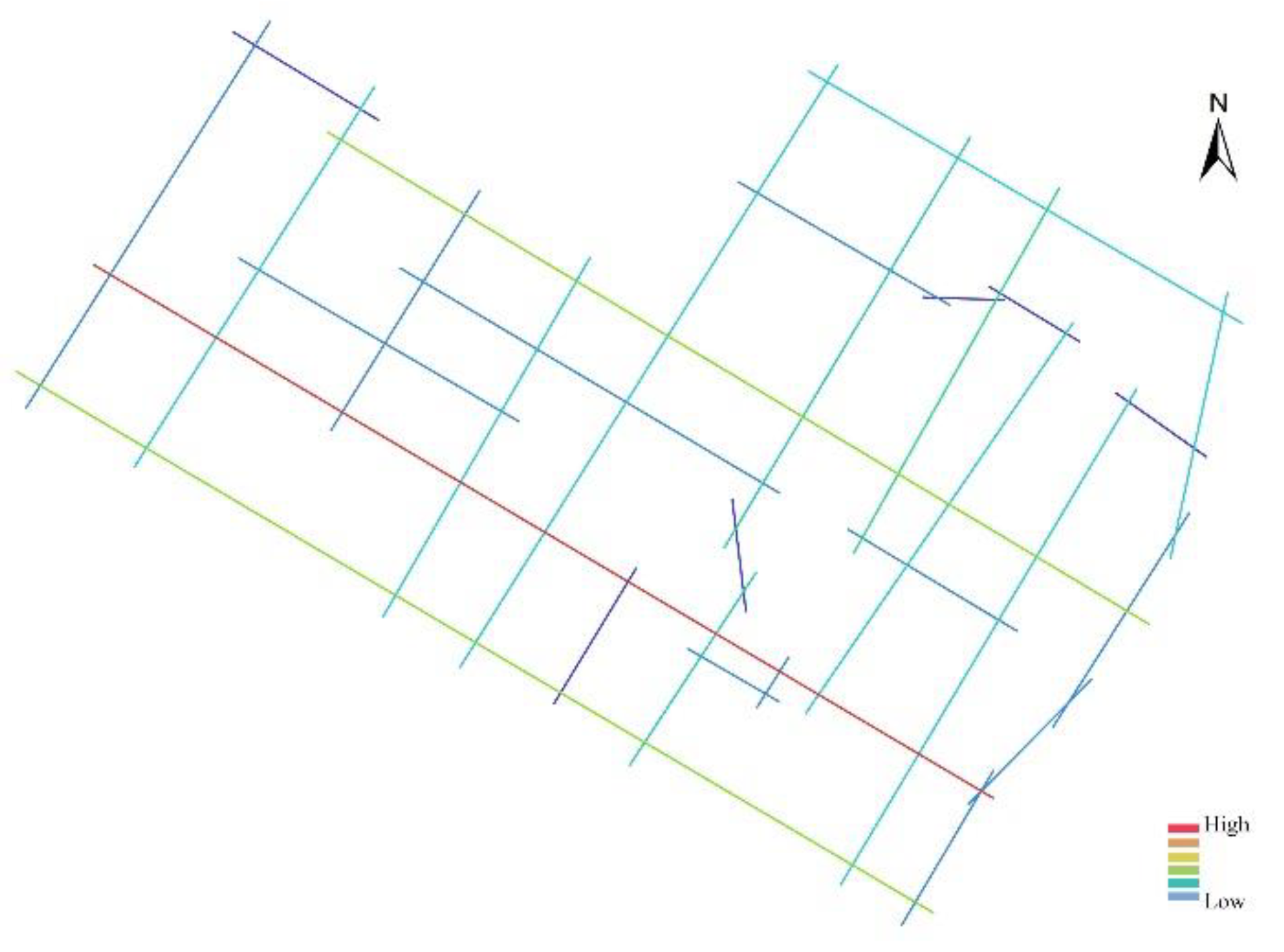
Global integration describes how closely a space is connected with all other spaces. The part of axial lines with higher integration in the axial lines system is often the spatial core, whose spatial accessibility and publicness degree is higher and plays an essential role in the district. Analyzing the global integration map (
Figure 3) shows that its spatial core position is relatively apparent, and the red axial lines with high integration constitute the spatial core of the Sishengci historic district. In this case, it refers to the axial lines with the highest integration, namely the axial lines formed by Xinglong Street, Huaxingshang Street, Huaxingzheng Street, Huaxing East Street, Fanku Street, Rushian Street, Fuzi Street, and Wangfu Street, which shows a highlighted red color. It passes through the whole Sishengci historic district in the form of a straight line.
This axial line is located on one of the longer horizontal roads in the neighborhood and has high accessibility. These streets are the most accessible and convenient places in the district, where traffic and pedestrian flow are most frequent, and are also critical public spaces. The form of this space still maintains the original traditional form, and this axial line is adjacent to the Jinjiang Theater, Wangfujing Shopping Mall, and other public activity spaces, which is a relatively dense public space.
The Sishengci historic district is crisscrossed with streets and alleys and has many historical relics of cultural protection units. The Sishengci historic district has a high integration of axial lines concentrated throughout, with a prominent center of the district and a very convenient core space for transportation. It continues the spatial structure of the traditional district and is a living place suitable for human-spatial relations, social functions, and spatial relations. The short axial lines located near the Fuhe River and inside the district are less integrated, and the district has more residential buildings. However, some of its spaces are relatively less accessible because they are located relatively deeper in the road. In conclusion, the Sishengci historic district has apparent spatial integration with significant core spaces, while some spaces are less integrated due to the distribution of roads and their locations.
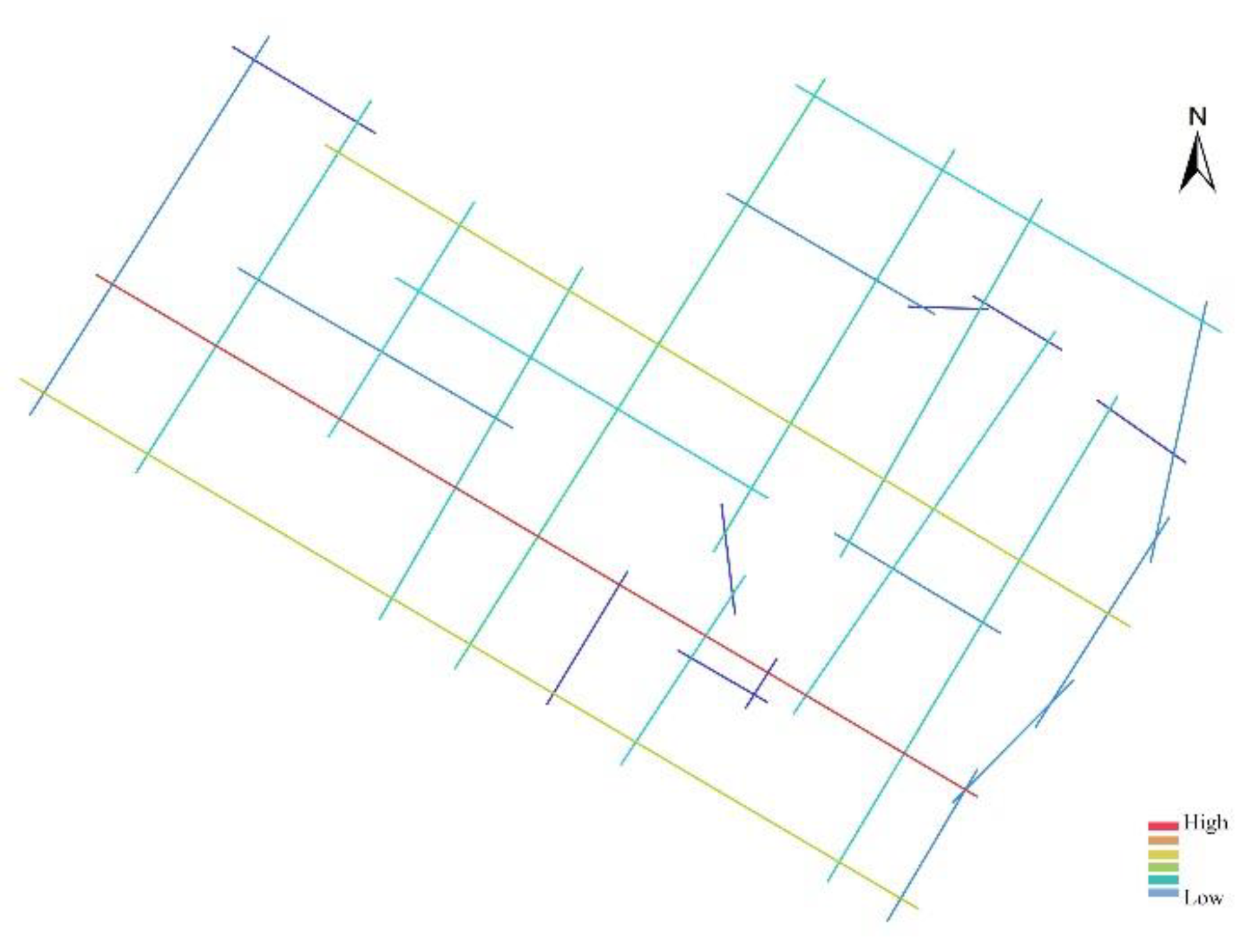
3.2. Connectivity Analysis
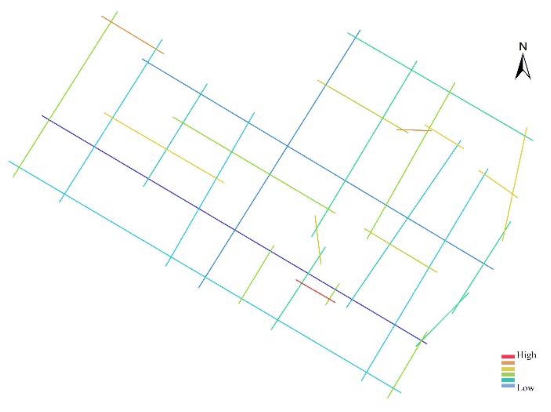
The connectivity indicates the number of axial lines directly connected to an axial line. The higher the spatial connectivity, the higher the breadth of visual penetration. The connectivity value map (
Figure 4) shows that the connectivity value of the axial lines connecting Xinglong Street, Huaxingshang Street, Huaxingzheng Street, Huaxing East Street, Fanku Street, Rushian Street, Fuzi Street, and Wangfu Street is very high at 12. This axial line is very regular and points to the center of the district, indicating that the road in the center of the district has strong permeability and takes on a crucial traffic function. Among them, Huaxing Street is the most prosperous section of the whole area of commerce and trade. Sichuan Daily Newspaper Press Group, Hampton By Hilton, and Western Culture Industry Center are in this area. The connectivity value of the axial line connecting Yuefu Street and Wucheng Avenue is also high, with a connectivity value of 9, and their directions are consistent with the center of the district. The axial line connectivity value at Hongxing Road is 6, closer to the center of the district and connects the school and transportation stations with the center of the district. In general, the Sishengci historic district extends in two directions, northeast–southwest and northwest–southeast, regardless of the direction of the roads or rivers. The development trend of its historical urban space is basically along this direction. Axial lines with low connectivity values are scattered within the district, which is related to the fact that the roads are irregularly connected, causing obstruction to the sight lines and affecting the connectivity values.
3.3. Control Analysis
The Sishengci historic district is the earliest cluster of Western-style buildings in Sichuan, China, with a full range of types, including churches, hospitals, schools, and residential houses. The analysis was conducted from the control values and indicates the degree of influence of space on its adjacent spaces; higher values indicate that it is easier to reach. In the control value map (
Figure 5), it can be seen that the axial lines formed by Xinglong Street, Huaxingshang Street, Huaxingzheng Street, Huaxing East Street, Fanku Street, Rushian Street, Fuzi Street, and Wangfu Street have the highest control value, which is importantly related to the fact that the roads on the axial lines are connected to many streets in the district. This shows the high control of the central space of the district in the Sishengci historic district. The high intensity of control of the center of the neighborhood over the surrounding spaces adjacent to it indicates that it occupies a certain position in the district and has a strong influence, and the space extending along this direction can become a field for the future spatial development of the historic district. The short axial lines in the district have low control values, indicating that these axial line spaces do not have a high degree of mutual control with each other.
3.4. Depth Analysis
The streets in the Sishengci historic district are narrow. They are used for social interaction on foot or by bicycle, so the streets are public spaces for people to carry out their activities. The analysis is carried out from the depth value, which indicates the minimum number of spatial transitions required to reach other spaces in a system. The higher the depth value, the less accessible the space is, and the lower the intensity of human activities in this space. In the depth value map (
Figure 6), the axial lines with lower depth values are mainly located in the center of the district, Xinglong Street, Huaxingshang Street, Huaxingzheng Street, Huaxing East Street, Fanku Street, Rushian Street, Fuzi Street, and Wangfu Street, which are road spaces with higher accessibility. This axial line divides the district, and this road division pattern helps to disperse people’s flow, which is in line with the development law of the human living environment. The axial lines with higher depth values are concentrated and distributed in the same area as the overall higher integration range, indicating that these spaces of Xinglong Street, Huaxingshang Street, Huaxingzheng Street, Huaxing East Street, Fanku Street, Rushian Street, Fuzhi Street, and Wangfu Street are closely connected to the center of the district and easily accessible.
3.5. Intelligibility Analysis
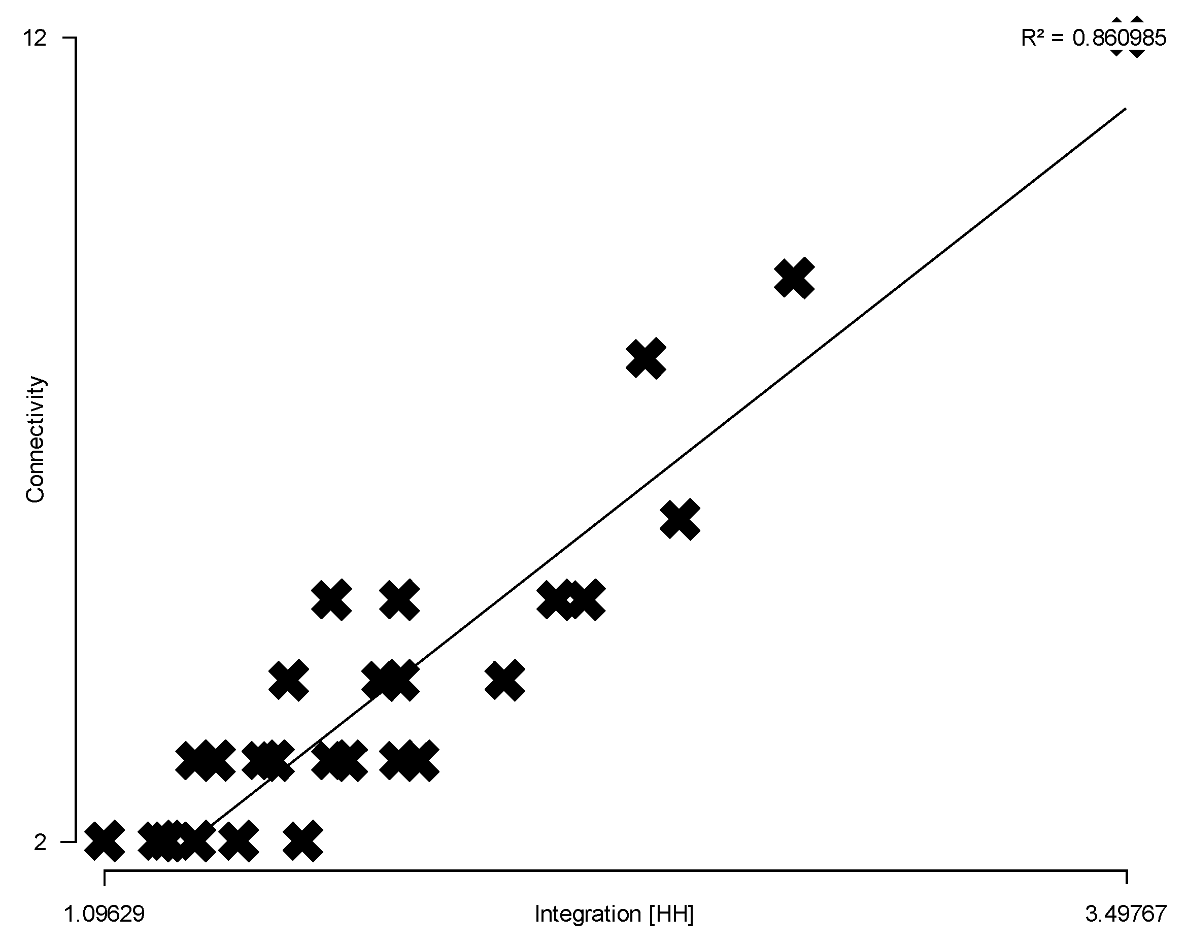
Sishengci historic district is the starting point of Western medicine in Sichuan, the origin of modern medicine in Sichuan, and once made a significant contribution to the life and health of the Sichuan people. In terms of intelligibility analysis, intelligibility is a variable that represents the relationship between connectivity and global integration, and its value is expressed by the linear regression coefficient
between these two types of variables. Intelligibility is used to represent and index the readability of the overall space based on the local space. It means the amount of connected space seen from space can be a helpful guide to integrating the space that we cannot see. It can be used to measure whether the local spatial structure seen contributes to the understanding of the overall spatial system. An unintelligible environment can be interpreted as a rupture of this cognitive and grouping relationship. In the intelligibility analysis, the connectivity was selected for linear regression analysis with the global integration, and the intelligibility of the axial lines system was derived from the
scatter plot (
Figure 7) to quantify the spatial relationship between the historic district locally and as a whole. In the figure,
denotes global integration,
denotes connectivity, and
denotes intelligibility. The red dots at the top right indicate the axial lines with higher intelligibility, while the blue dots at the bottom left indicate axial lines with lower intelligibility.
The scatterplot shows that the axial lines represented by the red dots with high intelligibility are formed by the connection of Xinglong Street, Huaxingshang Street, Huaxingzheng Street, Huaxing East Street, Fanku Street, Rushian Street, Fuzi Street, and Wangfu Street. These axial lines are surrounded by critical public spaces, in line with the axial lines in the center of the district. They occupy an important position in the district and are iconic. The intelligibility value of the Sishengci historic district is about 0.86, which is high. It shows that it is easier to perceive the overall spatial system of the historic district from the local space, the recognition of the streets is high, and its street space presents a regular form. During the development process of the historic district, attention should be paid to the conservation of the texture and natural form of the historic district.
4. Conservation Strategies for the Sishengci Historic District
As a carrier of urban heritage, the systematic conservation, utilization, and inheritance of historical and cultural heritage in urban construction are of great significance to the continuation of the city’s history and culture and the promotion of urban development. When carrying out district conservation, it is possible to refer to the syntactic model data to understand the district characteristics. Here, the example of the Sishengci historic district in Chengdu is used as a reference for the conservation of historic districts.
(1) Conservation of the core area of the district. A long-term practice called conservation works to prevent harm to a building’s or area’s unique character. It is a deliberate process that, over time, maintains little change. According to The Burra Charter, conservation refers to all actions taken to safeguard a location in order to maintain its cultural relevance [
34]. The term “conservation” encompasses all aspects of preservation together with interventions of every sort, including restructuring, revitalization, restoration, and regeneration. The historic district has a long history and preserves a splendid architectural heritage. The core of these historic districts’ overall space is Xinglong Street, Huaxingshang Street, Huaxingzheng Street, Huaxing East Street, Fanku Street, Rushian Street, Fuzi Street, and Wangfu Street, which is the crucial object of the district’s protection. Chengdu, as a historical city, has carried out region-wide tourism in recent years, which has caused a certain impact on the conservation of historic districts. According to the spatial axial lines analysis, the complete preservation of the local and overall core areas should be firmly ensured so their spatial forms are not destroyed, and the core influence of the cultural sources is brought into play. Under the premise of conservation, the tourist flow should be adequately controlled to avoid destroying the protected area space and architecture.
(2) Emphasis on street space interaction function. People exist in local social life practices, and their daily settlement behavior constantly repeats their experience of place and strengthens their interaction with it, making it a key element in the construction of self-identity and reflecting the strong connection between people and place. As a result, history is not only fixed in the buildings of the historic district, but also penetrates into the lives, work, and social networks of the residents. The conservation of historic districts should also focus on promoting community management, activities, and cultural promotion. The core concept of conservation also lies in promoting sustainable social development through economic and cultural recovery and other diversified means. Therefore, it is important to pay attention to the participation of residents in the conservation of historic districts and inform them in time to enhance their sense of participation. The street space in the historic district is mainly a space where people’s behavioral activities are frequent and communication is high, so it is possible to set up benches, landscape vignettes, and other resting service facilities according to the current situation to increase the time of people staying in the space and play the interaction function of the street space. By continuing the existing social networks and daily life experiences, the conservation of the Sishengci historic district integrates the residents into the social space of the district and preserves the spatial connections between the residents and the original social attributes of the Sishengci historic district. By creating multi-level tourism routes, visitors can learn about the actual residents’ living conditions and have a richer viewing experience while traveling. As a common memory of urban residents’ life, the historic district space is a valuable resource for future development and can inject new vitality into the city [
35,
36].
(3) Extraction of the cultural genes of the historic district. The public space of the historic district has the functions of worship, assembly, life, and transportation, closely related to the life of residents and the activities of visitors, and is a valuable material cultural heritage of the historic district, as well as a carrier of immaterial culture. As imagery of material culture and living environment, the Sishengci historic district can be regarded as a container of time. Once the past time is attached to the long-established heritage, it is bound to penetrate into countless fragmented individual experiences and is constantly reshaped by recollection or forgetfulness, taking on a variety of complex forms, not so much as real history, but as constructed memory [
37]. Therefore, in the conservation process, in addition to adhering to the basis of authenticity and cultural living preservation, we must also fully understand the spatial characteristics of the heritage resources in the historic district, refine the cultural genes of the ancient town, and excavate the deep cultural structure. By making architectural places and cultural symbols of historical relics into cultural carriers, shaping local characteristics and creating memories of places, triggering pride and identity of residents in their way of life, and promoting positive human experiences in historic districts, they become a set of readable symbols and messages that become an environment that expresses itself [
38]. The future can be based on this to attract socio-economic investment and implement industrial operations through cultural heritage and innovation.
5. Discussion
In recent years, research has begun to focus on historic districts in cities, and quantitative studies can accurately determine the problems in the spatial development process of the districts and remedy the current situation that heritage planning projects ignore the relationship between the local and the whole. Koohsari used the historic district of Taiping Street in Changsha, China, as an example, compared the cognitive map and the syntactic model, and found that the syntactic model and the cognitive map’s nodes had a strong correlation, as well as the road networks [
39]. Using axial and image maps, Yu and Liu investigated a specific variation of Gulangyu Island in Xiamen, China [
40]. Kubat investigated pedestrian and vehicular activities in Sharjah historic center in the United Arab Emirates (UAE) to comprehend the existing movement patterns and examine the physical structure [
41]. Wang and Bramwell compared historical urban districts in China using a space syntax [
42]. Previous research results have focused on comparing and analyzing the relationship between space syntax and cognition to provide a basis for the design process. In this study, we use the integration, connectivity, control value, depth value, and intelligibility of space syntax theory to dissect the spatial cognition of the Sishengci historic district, not only to analyze the spatial structure but also to propose the conservation strategy of the historic district as a result, which provides a new perspective for the study of strategic conservation of the historic district.
In this study, some insights can be drawn from the case of the Sishengci historic district in the conservation and development of historic districts. Quantitative analysis should be integrated into the whole dynamic process of district conservation and development. The conservation of historic districts is a dynamic process. Urban problems will arise if the focus is only on the material heritage, such as historic buildings and historical relics, ignoring the social logic of space formation. It is necessary to comprehensively balance various factors, such as people’s life, historical carriers, and newly implanted functions, and quantitative analysis and simulation integrated into the process of district conservation can maximize the conservation of the spatial structure and material carriers of historic districts. For example, in the stage of historic district conservation planning, quantitative analysis by space syntax is used to investigate, analyze the spatial structure of the district, and delineate the core conservation area of the district, which can maximize the conservation of the physical environment and social structure of the district.
6. Conclusions
Conservation of the historic districts’ space is an important way for cities to inherit history and continue their cultural lineage. The formation of the historic district is influenced by various factors, such as natural conditions and social development, and its spatial form has shown its inherent development law in the development process. This study analyzes the space of the Sishengci historic district based on the space syntax, aiming to study the spatial form of the conservation and development strategy of the Sishengci historic district from a new perspective. The overall space and street space of the historic district are interpreted through the space syntax, analyzed in terms of integration, connectivity, control value, depth value, and intelligibility, and the conservation strategies are proposed in a targeted manner: emphasizing the focus on conserving the core area in the whole, refining the cultural genes of the historic district in the spirit, and emphasizing the street space interaction function in the social attributes, all of which have a guiding significance for the conservation and renewal of the space of the Sishengci historic district.
The analysis of the morphology of the historic district through the space syntax and the exploration of targeted development strategies are conducive to the inheritance of historical culture, regional characteristics, and the development of spatial morphology. At the same time, it is also conducive to the conservation and continuation of the spatial configuration of the historic district from a long-term perspective and the systematic conservation and development from a sustainable development perspective. Historic districts rich in cultural connotation and place memory not only promote the creation of urban image and cultural value but also satisfy people’s pursuit of culture and spiritual enjoyment in the future, which has important strategic significance for the development of historic district space in Chengdu.


