
Systematic Review on Civilian Drones in Safety and Security Applications


Department of Electronic and Electrical Engineering, College of Engineering, Design and Physical Sciences, Brunel University London, Uxbridge UB8 3PH, UK
*
Author to whom correspondence should be addressed.
Drones 2023, 7(3), 210; https://doi.org/10.3390/drones7030210
Submission received: 8 February 2023
/
Revised: 27 February 2023
/
Accepted: 28 February 2023
/
Published: 18 March 2023
Abstract
:The employment of unmanned aerial vehicles, also known as UAVs, is expanding rapidly across various civil application areas. Some of these domains include real-time tracking, the provision of wireless coverage, sensing, searches and rescue, the delivery of goods, safety and surveillance, security, and safety checks of engineering structures. Smart UAVs represent the next technology revolution in UAV technology. They promise to provide new possibilities in various applications, notably lower risk and costs for civil infrastructure. The military has traditionally used unmanned aerial vehicles (UAVs) in countries such as the United Kingdom or the United States to partake in military and dangerous operations. The application and usage of these UAVs have become more commercial. Civilians can easily buy UAVs, commonly known as drones, from online platforms or shops. The main aim of this study is to review selected publications presenting previous efforts on using Civilian Drones in Safety applications. The study was accomplished using a systematic review research approach reviewing 45 publications. Drones have become more common, and it is crucial to understand how they work, especially since they entered the civilian domain. The research shows how civilian drones have been used in numerous safety applications, such as security cameras videotaping a house to ensure its safety.
1. Introduction
Drones are unpiloted and unmanned aircraft. They are sometimes known as unmanned aerial vehicles or UAVs for short [1]. They operate without a human pilot on board. They have different levels of autonomy. A drone can rely on its own systems that houses Light Detection and Ranging (LIDAR) detectors, sensitive sensors, all of which are used to calculate its movements and its surroundings, ensuring it does not crash while on its flight plan. This is known as autopilot or advanced autonomy [2]. It can also rely on a human controlling its movements, known as a remotely piloted autonomy. Drones come in different sizes and shapes depending on what task they are completing. They have varying travelling capabilities in the high and distance that they can go. Very close-range drones can travel up to three miles. These are commonly used by hobbyists. Meanwhile close-range drones can have a range up to 30 miles [3]. The longest-range drones can travel up to or beyond 400 miles and 3000 feet in the sky.
There are many purposes for them, ranging from collecting data for scientists to dropping groceries off or even finding people trapped under debris or avalanches. These drones are commonly used for dangerous tasks. They were originally created for aerospace industries as well as the military to aid in their tasks [4]. The drones were commonly used for safety applications such as ensuring that an area was safe for troops to move in to, or to see if someone was buried under rubble before rescue teams went in, and in some cases used in place of soldiers where drones are fitted with weapons such as bombs [4]. Over the years, drone technology has become mainstream and has slowly entered into civilian hands due to their efficiency and the effective safety they can bring. Civilian drones can be used to carry groceries to the doorstep or to photograph any view a person wants from different angles or heights [5].
Drones can supplement human guards by conducting site inspections, obtaining aerial footage of resources, securing perimeters, and attempting to prevent break-ins [6]. They can also be used to patrol work sites. They can provide real-time data streaming around the clock because they are integrated with AI technologies [7]. On the other hand, the monitoring drone foreshadows the development of new applications for “tomorrow’s security” due to the extraordinary observation and movement possibilities it offers, which are continually being improved by the most recent technological advances. Because of its wide range of applications and significant operational value, it is an invaluable air asset in complex or high-stakes circumstances, regardless of whether the situation involves public or private security [8]. Therefore, the success of a drone safety system is based, above and beyond its technical features, on its operations and maintenance functionalities, the application intelligence created, and its ability to be embraced by professionals [9]. In the performance of their duties, security officers can benefit significantly from using professional drones because they enable them to reduce potential dangers, foresee potential hazards, and respond to emergencies at an earlier stage. The expert drone is, therefore, exceptionally suitable for use in safety and security; it also meets the requirements of public safety and security, such as monitoring mega events or monitoring outdoor venues. Altawy et al. [10] also conducted a study on safety and security in sporting events. As a result, it is possible to incorporate it into the services offered by private security companies, where it would bolster the overarching risk management plan and work closely with team members of security officers. Therefore, the benefits are an increase in quality, a decrease in emissions, and a safety improvement. As a result of the substantial benefits that unmanned surface vehicles (USVs) provide in the areas of efficiency, costs, ecologic imprint, logistical support, and safety, this field is undergoing increased utilization and development. Altawy et al. [10] found that hobbyists using drones recreationally currently account for the vast majority of civilian drone usage.
This paper seeks to provide a comprehensive systematic review extracted from 45 published articles within the year of 2011 to 2021; in order to highlight the potential for using drones for safety and security purposes. In addition, it will enable the identification of different areas that could benefit from drones to achieve better security and safety outcomes. Moreover, the paper will be very beneficial for researchers, developers, and other stakeholders to have one reference that includes a summary of a wide range of references to refer to achieve future objectives, rather than spending more time on searching and reviewing.
The paper has been structured into five sections. Following this introduction, the research methodology is presented, followed by the findings from the systematic review, the findings from the meta-analysis, discussion, and conclusion. The references follow the main body.
2. Research Methodology
2.1. Research Desing (Qualitative Research Design)
The study used qualitative research design in order to do a systematic literature review. It’s possible to conduct a systematic review using either qualitative or quantitative methods or a hybrid of the two [11]. The research topic and the breadth of the investigation both play a role in determining the methodology that will be utilised [12]. The term “mixed method” refers to an approach to research that combines qualitative and quantitative approaches within the same investigation. One way to compile research on a subject is through a systematic qualitative review, which involves searching in an organized manner for research evidence from primary qualitative studies and then bringing those findings together [13]. The question of whether or not it is necessary for the search to be comprehensive is currently being discussed. In a qualitative literature review, the data from the studies are analysed using either a qualitative approach, a thematic approach, or a narrative approach. However, the study’s objectives lead us to use qualitative systematic literature review. Using a qualitative research approach is to evaluate the factors and elements that implement the applications of drones in safety and security purposes.
2.2. Systematic Literature Review
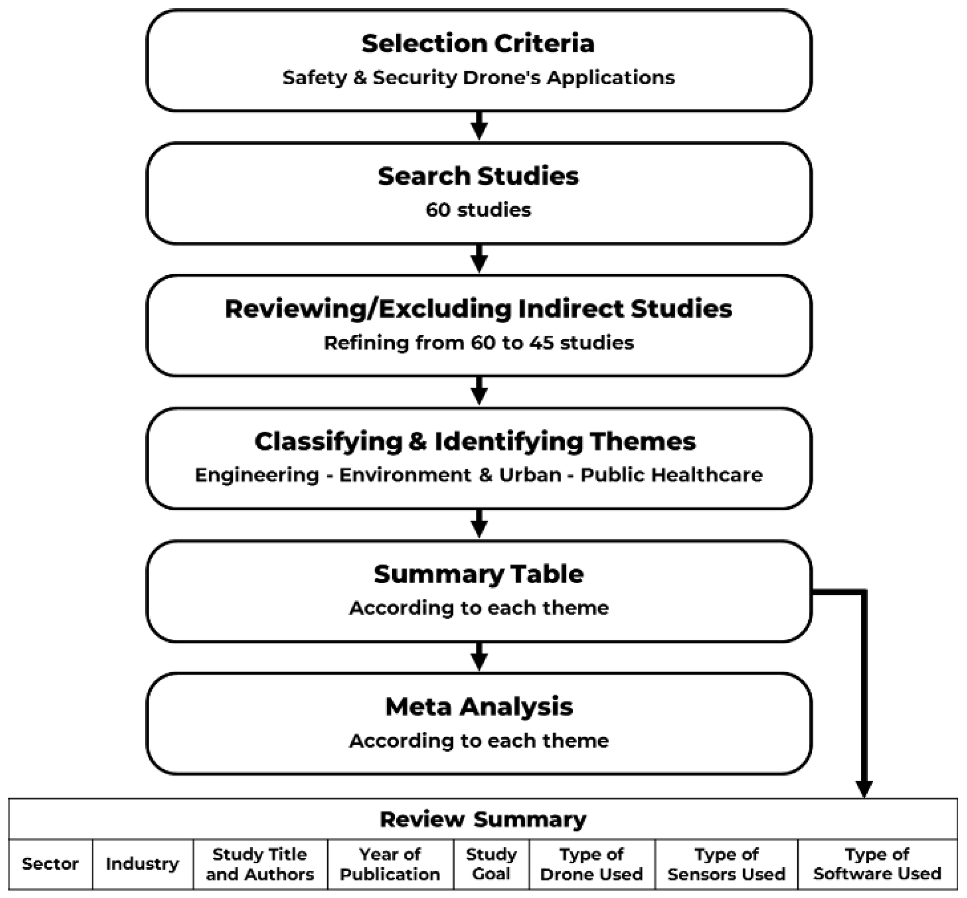
As illustrated in Figure 1 for this study, a systematic review method has been used. A systematic review is a style of analysis that researchers carry out to find all different forms of evidence on a particular question [14]. This form of review is seen as a reliable source of evidence due to it critically reviewing and giving a summary of different research papers that can help with research. The papers and publications reviewed are known as secondary research and data. This data and research are done by someone else. These reviews are needed to establish a better understanding of the research field and to generate new data. This literature review is different from a systematic review. Unlike the literature review, which is also called narrative review, which represents all available information on a given subject or topic, whereas a systematic review attempts to find all the materials and resources available that answer a specific question the researcher has [15]. Therefore, a systematic literature review is used to identify the factors that lead companies and organizations to implement drone usage in safety and security.
For those who are interested in UAV (drone) technology, the following contributions were made by researchers who used cyber security and safety to advance their work. The present investigation is supplemented by this systemic literature review (SLR), which offers these contributions. While searching for UAV papers about this particular field, we found thirty primary studies. In order to provide an up-to-date perspective of the UAV, we perform an analysis of the data that was collected by the different studies and present our findings. Our goal in conducting this review is to acquire a more in-depth understanding of the topic. This review aims to investigate the many different approaches that can be taken to improve the security of a wide variety of cybertechnologies. Through establishing guidelines and making representations, we hope to stimulate additional research in this area. The following section will also discuss the numerous facets of UAV security in depth.
2.3. Inclusion and Exclusion Criteria
This article aims to conduct a literature review on safety and security using unmanned aerial vehicles (UAVs), specifically focusing on cybersecurity problems and potential solutions applicable to this context. The study selection criteria were applied to select the papers most pertinent for the review. After compiling the results of the search, the information was run through Google scholar to locate the most relevant papers. The criteria used to decide which papers should be included and which should be excluded from the primary studies are outlined. The search string pertaining to UAVs in safety and security was utilised to search through the hundreds of research papers available. Following the removal of duplicates and studies that were not relevant to the topic at hand, there were 45 research papers left to evaluate using the inclusion and exclusion criteria. Following the application of the criteria, there were a total of 60 papers retained. The discovery of two and three additional papers through snowballing in different directions brought the total number of papers included in this SLR up to 45.
2.4. Data Extraction
Since we now have our complete set of research papers, the next step is to plot out how we will extract information from them. Considering that safety and security are connected to the subject that we are discussing, the first thing that we look for safety and security through UAVs. We are looking for those papers that contain extensive information regarding the safety of UAVs, and in order to evaluate it, we will use the information on UAVs that was provided by other papers. In order to conduct additional research, we created two categories and then divided the papers into those categories. These classifications are as follows:
The UAV: Its Functions and Use-Cases Threats, attacks, and potential countermeasures are discussed with regard to safety and security.
2.5. Selection Criteria of Sampling
This study focused on civilian drones in safety and security application as the criteria for inclusion in this review, hence, 60 articles have been reviewed and only 45 articles included (Figure 1). This allows us to see all possible research that show similar results or similar hypotheses or understanding on how civilian drones can be utilized in safety and security applications. Another selection criterion was to only cover publications within the period of 10 years from 2011 to 2021, to see if past observations and findings align with present ones. Each review will note down the aim of the study, the method used within the study, their findings as well as recommendation for future research and conclusions. That have been useful to establish and refine classification diagram to represent the four candidate industries for drones’ application in safety and security purposes along with three key areas within each industry.
2.6. Meta-Analysis
Meta-analysis is an important component of this systematic review because it allows for the analysis of previous studies’ summarized findings in Table 1, to identify trends and features within the studies conducted. In other words, it involves analyzing the analyses of other studies to gain a deeper understanding of the data [16]. Therefore, meta-analysis has been used in this study to establish when and where studies were focused, a high of systems used basic GPS and camera within the application, in addition to the use of advanced sensors and software.
3. Findings from SLR
As highlighted in the methodology section for the systematic review findings, in Table 1, essential items were included to enable the achievement of the goal of this study. It starts with identifying the drone application sector, industry of use, study title and authors, year of publication, study goal, type of drone used, type of sensors used, type of software used, and finally, the key outcomes from the study were listed following each.
From Table 1, the key findings from SLR(a) on drones’ applications for security and safety within the engineering sector can be summarized as follows:
- Drone technology has a range of applications in different industries, including construction, mining, and urban development. In construction, drones can make managers’ safety inspections easier by providing real-time footage and pictures, and by spotting hazards much quicker than human inspectors [17]. Drones can also improve worker safety by performing tasks that are hard for them to do, such as mapping areas and using thermal imagery to ensure site stability, and they can save time and money for those who use them [18].
- However, more work and research are required to use drones on a daily basis and outside of a controlled environment, and the hazards associated with drones have not been thoroughly researched [19,23]. Nevertheless, participants in studies found the benefits of drone usage to be positive and preferred the clear view it provided [22,28].
- In the mining industry, drones can help with the challenges faced by workers [26], but some types of drones and sensors face challenges, which suggests more research on alternative drone usage is needed [27]. In construction, the use of the 4D (3D + Schedule) BIM-based model system can mitigate accidents and fatalities during construction by following regulations and improving safety for all stakeholders [24].
- The proposed system of augmented reality (AR) and drones can provide safety for difficult and dangerous access for humans and modify and perform different operations for the models created by the system [25].
- In urban development, smart cities are turning to technology, including drones, to improve their quality of life, accommodate new residents, and offer benefits such as package delivery, policing, traffic monitoring, and ambulance drones [30].
- Overall, drone technology has a variety of applications in engineering sector, and while more research is needed to address the hazards and improve daily usage, their benefits cannot be overlooked.
From Table 1, key findings from SLR(b) for drones’ applications for security and safety within the environment and urban sector can be summarized as follows:
- Drones have proven to be useful in a variety of applications, including environmental monitoring and gas detection. In one study, drones equipped with gas monitors accurately determined the amount of gas released from known sites [31]. However, it is important to consider the potential risks associated with drone usage. While drones can aid in management, it is necessary to determine if their benefits outweigh the risks [32].
- One advantage of using drones for environmental monitoring is the ability to install sensors and software specific to certain tasks, such as monitoring ground movement. This not only provides a more comprehensive view but also increases human safety and reduces the need for physically demanding work [33].
- Drone control systems offer users the ability to manually fly the drone or set waypoints that conform to a desired trajectory. Google Maps can be used to ensure the drone stays on course and does not pose a danger to those on the ground [34].
- While drones have shown promising results in various applications, more research is needed, particularly in active environments such as roads outside of university campuses. Researchers have also identified the potential for drones to identify conflicts [35].
- As the popularity of drones continues to increase, it is necessary to study their long-term impact on infrastructure and transportation. Additionally, achieving unmanned aircraft traffic management within the next five years could enhance economic growth while maintaining privacy for those not involved in drone operations [36].
- One proposed application for drones is a swarm of autonomous drones that can assist first-responders from multiple organizations. Researchers plan to study path selection mechanisms to reduce end-to-end delay using a wireless mesh network [38].
From Table 1, key findings from the systematic literature review on drones’ applications for security and safety within the public sector can be summarized as follows:
- With the rise of police drones, the radical asymmetry between the techniques of the hunters and the hunted becomes more apparent, bringing this relationship of dominance even more to the forefront, in a similar but even more dramatic fashion than SWAT teams and armored vehicles. This unmanning of the police manhunt is but the newest symbol of the pacification project that the poor and oppressed have been living and dying under. Pacification, however, always assumes populations that resist and is, therefore, never a completed project [39].
- For homeland security missions, UAV requirements and preliminaries are largely different from those for military operations. UAVs transmit telemetry and payload data using frequencies that are not owned by homeland security agencies. As fire and police departments have limited funding, cost is also a major concern for them. On the other hand, the requirements for payload weight, operating conditions, and ranges are relatively lax. Work on getting past these issues is needed [40].
- Firefighters support the use of drones due to their benefits, and future work should consider using drones in a real fire situation to see if they are still functional or beneficial [41]. UAVs will be beneficial for the network, but more research on how to solve issues is needed [42]. One study notes how useful or strong the communication capability of the drone is. The study proposes that the D2D drone’s communication be extended to the wireless coverage of the public safety network [43]. Another study found that the drone was useful in tracking targeted people and worked well in the field. However, some issues came up that would need to be studied further to ensure they do not happen again in the field [44].
- Drones are shown to be a valuable tool for detecting sharks in one study, meeting increasing demands for better protection while remaining minimally destructive to marine life. Drones are useful in notifying staff and lifeguards when a shark has been spotted, making evacuation quicker [45]. It is important to understand people’s perception of this technology. Many of the people using this technology were pilots, army members, and first responders such as firefighters [47].
- Drones provide users with a bird’s eye view that can be used almost anywhere and at any time. In recent years, however, criminals and cybercriminals have begun to use drones maliciously [48]. Using surveillance drones is one way to detect amateur drones and is cost effective. More research on how to maximize the time and energy of the drone is needed [49].
- In sports, typically 80% of injuries are sprains, cramps, and abrasions. Drones equipped with Elide-brand fire extinguishable balls are used to stop fires during such accidents as soon as possible. Organizers of sports events can provide athletes with medical support with the aid of the solution presented here as quickly as possible. This is due to how effective drone usage is in ensuring the safety of athletes should an emergency occur [50].
- While humans could be replaced by robots and computers in jobs requiring physical exertion in hazardous conditions, automation can negatively impact the job market and can change people’s behavior, such as how they spend their free time. Technology during sports is viewed negatively when it engages in unacceptable, unjudged behavior defined as abusing modern technological solutions, commonly known as “technology doping.” A German competitor’s bicycle was found to have an electric engine in its frame in Heusden-Zolder in 2016 [51].
From Table 1, key findings from SLR(d), for drones’ applications for security and safety within healthcare sector can be summarised as followed:
- The United States faces a major challenge with drone companies. FAA regulations are causing limitations on drone operators, whether large or small. It is not possible to access some airspace. If cities and states released their aerial easements, that would be helpful. Medical innovation is encouraged by drones, which enhance supply logistical efficiency. Switzerland, Rwanda, and China all have drone delivery networks in place. In many hard-to-reach areas of the United States, there are several companies and organizations that can provide medical care and mail. Due to their top speed of 60 to 100 mph, drones can shorten supply chains since they don’t need to navigate through traffic. Since drones deliver goods directly to rural homes instead of distribution centres, they could also in-crease social distance. By downloading an app, you can have the grocery store employee’s load up your items and send them back to you [52].
- Drones are useful in aid of the healthcare sector. However, as this may be the first-time drones have been used during a pandemic, more research is needed [53]. Drone use will reduce human contact. This will reduce rates of infection and those who die from COVID 19. Nurses and doctors as well as patients will be safer [54]. Despite regulation issues, drones are a useful technology to use [55].
- By utilizing surgical robots to maintain high quality care, the healthcare system in Europe will operate at a much higher performance and cost-effectiveness. The operator should be close to the remote site in order to reduce performance degradation caused by large latencies. 5G technology would reduce latency issues, making mobile robotic surgery more accessible. This paper also presents a data sharing mechanism and personalized data analysis model for 5G-Smart Diabetes. A cyber-physical healthcare system allows the recognition of a patient’s condition at the first step of a fully digitized remote healthcare system. ML is used in a multi-layer framework that consists of many low-cost lightweight devices. 5G technology makes it possible to establish virtual hospitals via a communication channel, offering a variety of services [56].
- Researchers found that the drone transportation system tested in this study had no negative effects on the growth times of sample types or microbes. All microbes studied showed similar recovery times, colony counts, and morphologies [57]. These findings contribute to the development of future research directions for humanitarian drones, their performance outcomes, and their respective barriers. In this study, we analyze potential humanitarian applications of drones, and we present a comprehensive agenda to structure and guide future research on this topic [58].
- Drone usage in disaster areas is beneficial as it keeps people safe. In conclusion, they provide an example of how UAVs can be used to aid rescue teams in detecting and observing. This approach is nonetheless promising, both technically and operationally, in enhancing disaster management efforts. Search and rescue can benefit from drone use in a variety of ways. They are more likely to become a burden if they cannot function autonomously and independently [59]. Drones are capable of tracking people after implementing software and training them to move left or right to follow the person. Their durability makes them effective against falling debris or shaking of the ground. They are not perfect as their durability does need more work, as well as there being a need to implement programs where the drone, once it detects trouble, immediately moves out of the way to stay safe and keep tracking people. Overall, the use of drones in a disaster area is beneficial [60].
- Despite its limited payload capacity, wind speed, and flight endurance, small, remotely piloted aircraft can be used as effective tool carriers. A major incident scene can be assessed, and information exchanged using remote sensing using RPA technology already in use in pre-hospital settings. Future work on real-time video footage from an incident is important as it will allow decision-makers and situational analysts to assess [61].
4. Findings from Meta-Analysis
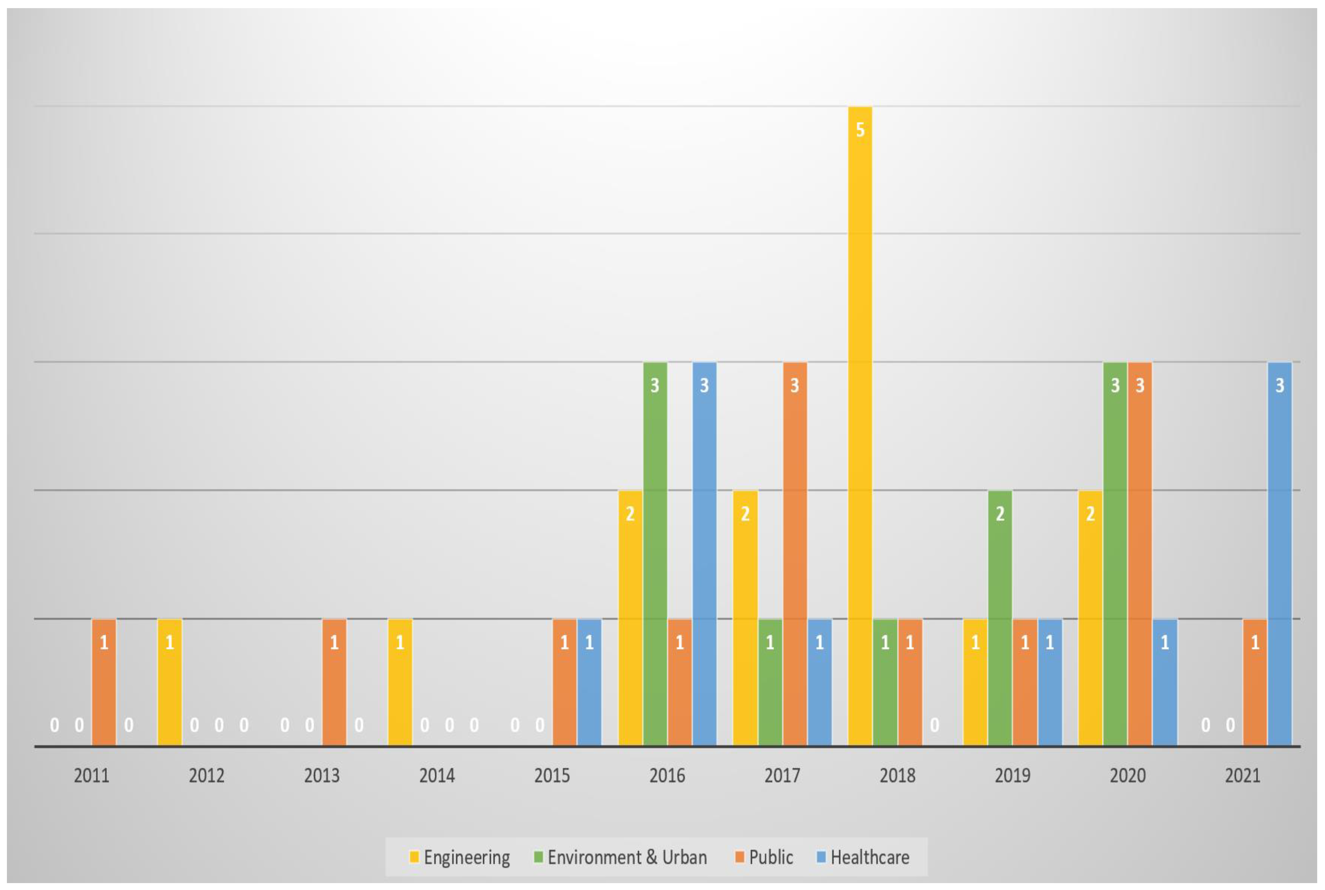
Figure 2 demonstrates the numbers of papers that have been taken place in the safety applications of drones to each theme—Engineering, Environment & Urban, Public, and Healthcare—during the last 10 years from 2011 to 2021. We considered the safety applications of drones of each theme—Engineering, Environment & Urban, Public, and Healthcare—during the last 10 years from 2011 to 2021. As the diagram shows, most of the selected papers to this research have been published just from the last 5 years of this study, while in the first 5 years are just a few papers from different themes.
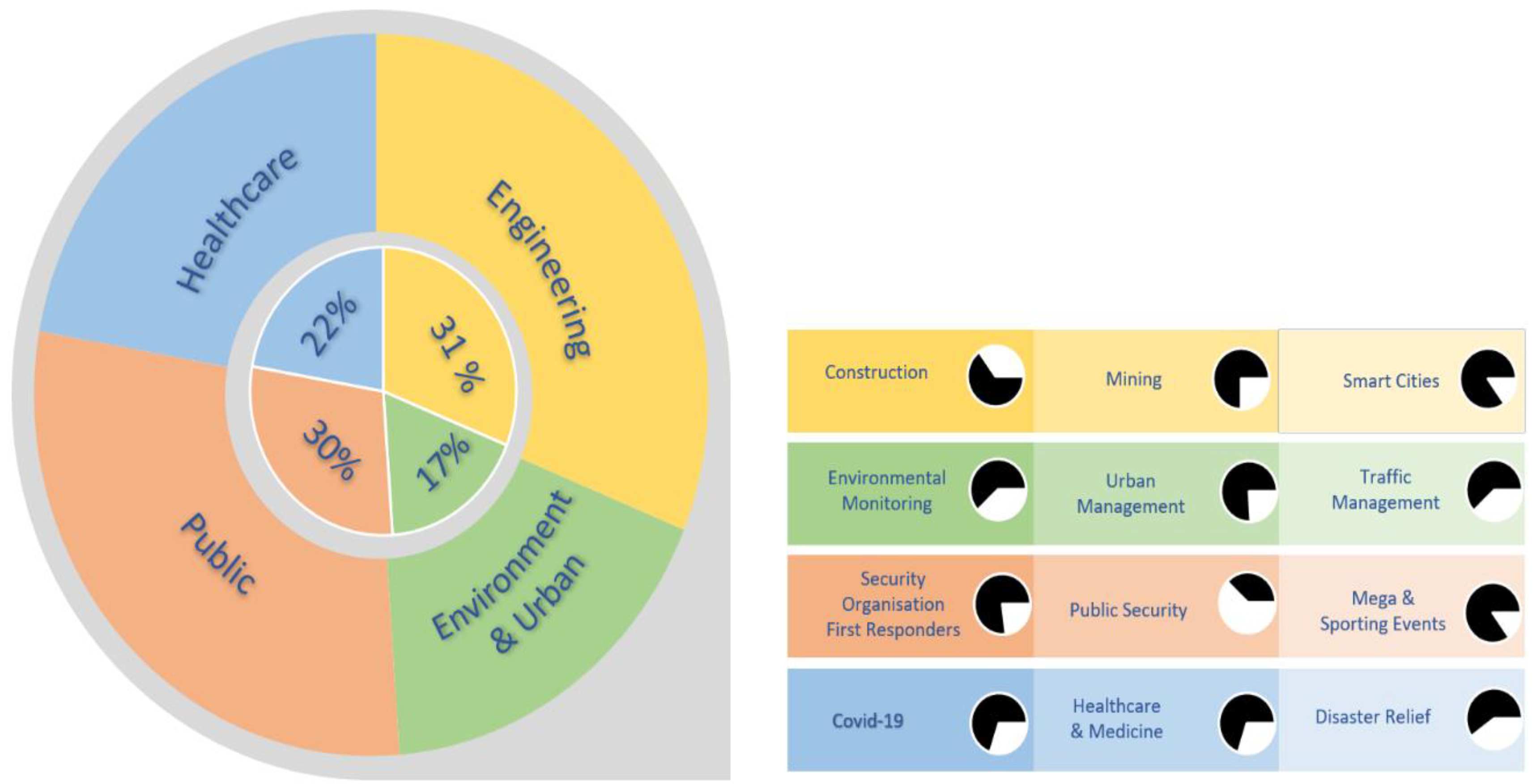
Figure 3 illustrates the percentage of each theme that has taken place in the safety applications of drones. The table on the right-hand side is an illustration showing the percentage of each industry in each theme, where the colours refer to each theme. The Engineering and Public themes have more focus on this research in comparison with the Environment & Urban and Healthcare themes.
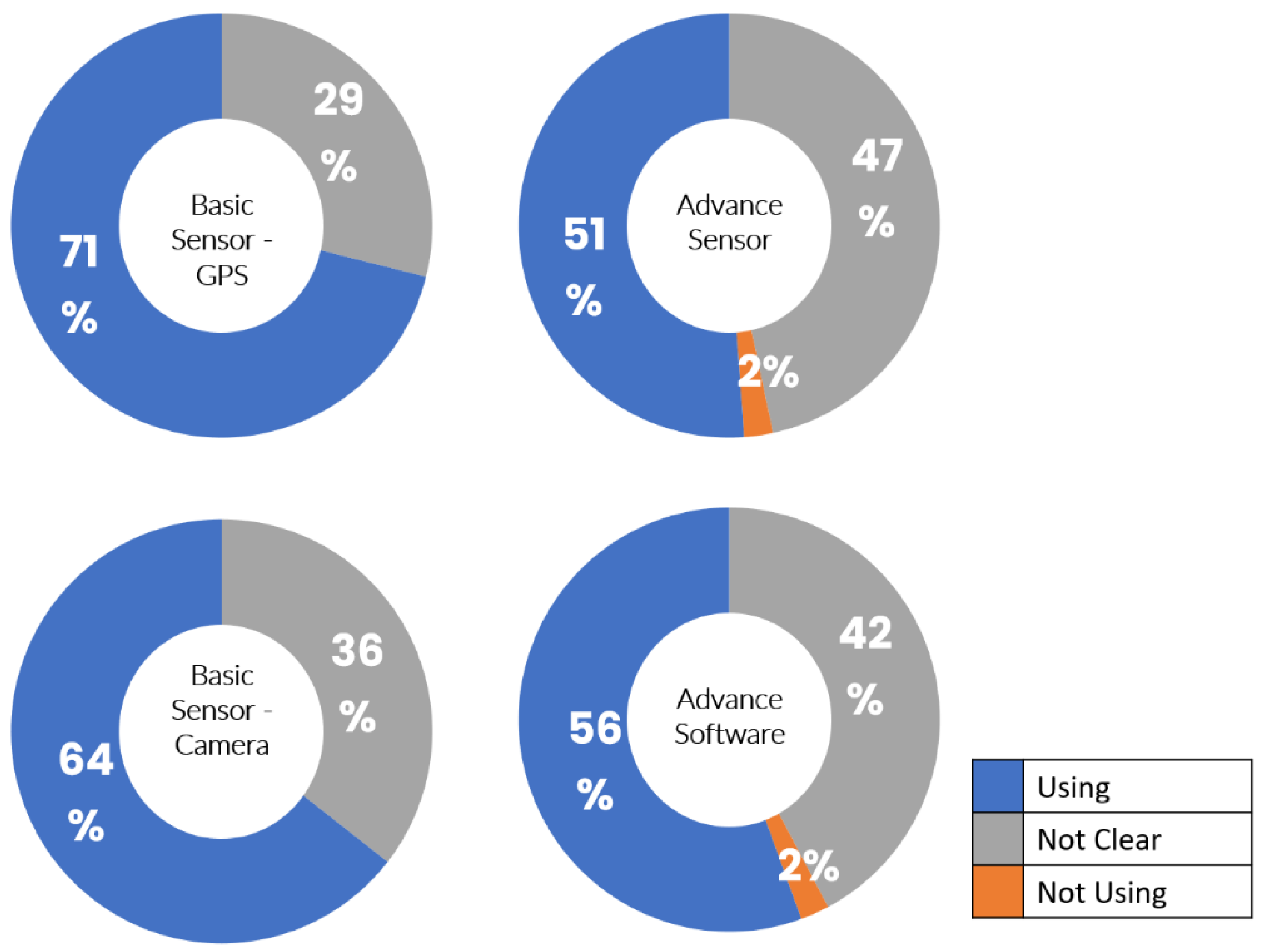
The pie charts in Figure 4, generated from Appendix A (Table A1). present the proportion of papers or studies that used drones with Basic Sensor GPS/Camera, Advance Sensor, and Advance Software in their research. As the diagrams show 71% of the involved studies in this research used the Basic Sensor as GPS and 64% of them used the Basic Sensor as a Camera. 51% of the involved studies used Advanced Sensors and 56% used Advance Software.
5. Discussion
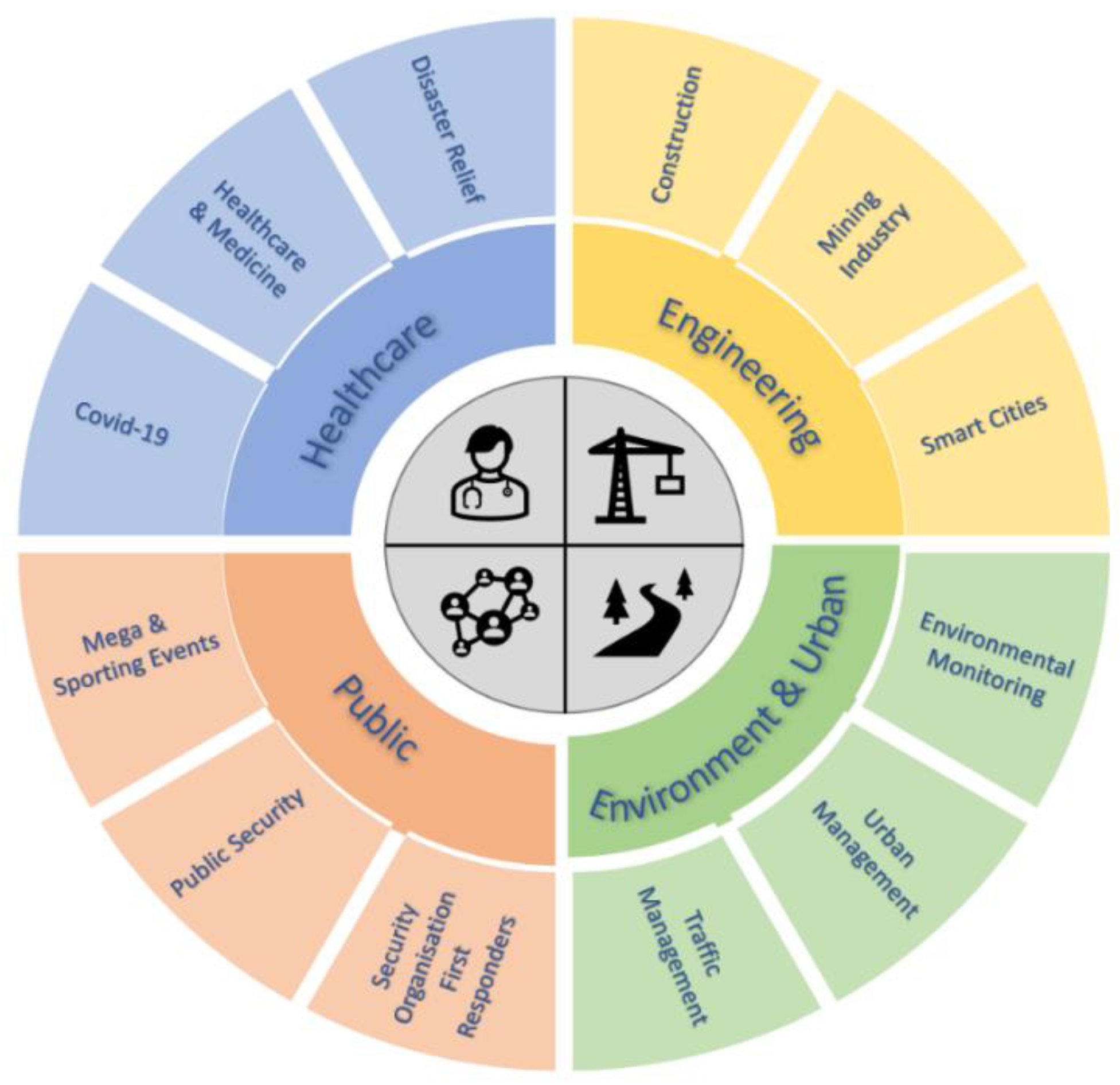
The outcomes of this systematic review clearly revealed that drones have great potential within the safety and security applications in different industries, as appears from the great increase in number of publications within the last 5 years of this study. Moreover, the analysis revealed that the majority of applications have used the global positioning system as the means of location sensor and camera in their system. Meanwhile, over 50% of the applications have extended to include advanced sensors and software to enable advanced applications. Furthermore, the systematic analysis revealed that there are two key areas which still have a limited number of publications or research papers, which are smart cities and mega sporting events. Figure 5 shows the comprehensive applications of drones in safety and security matters in Healthcare, Engineering, Public and Environment, and Urban units. In the field of drone technology, it is important to remember that drone technology is still evolving. Despite the endless opportunities they offer, challenges are still to be met to ensure the safe, secure, and effective deployment of drone applications in real life [62]. This includes various important aspects, such as privacy and security concerns [63,64] and energy restrictions of the battery on board [65]. Moreover. to ensure the safe and effective integration of unmanned aerial vehicles (UAVs) into global airspace, it is necessary to establish civilian UAV deployment frameworks in accordance with the global efforts endorsed by the International Civil Aviation Organization (ICAO) [66].
6. Conclusions
The main goal of this study was to conduct a systematic review of published papers from 2011 to 2021 in order to identify possible applications for drones in the areas of safety and security. It was clear from the systematic review that there is great potential for drone applications starting to emerge, mainly during the past five years, in these two domains across a wide range of sectors and industries. The study also revealed that drones need to be equipped with specific sensors and software to achieve such applications. Hence, further research is required to focus is needed to establish standards for safety and security a drones-based applications. The outcomes from this paper will be very useful in different ways, such as supporting further research and enabling stakeholders to use one paper as an index for 45 documents, allowing them to explore those applications further. The search was limited within the scope of the pre-identified systematic review criteria. It would be useful for future research to expand and identify key requirements for drone applications in safety and security in each sector.
Author Contributions
Conceptualization, K.A.-D. and Z.H.; methodology, K.A.-D. and Z.H.; investigation, K.A.-D. and Z.H.; writing original draft preparation, K.A.-D.; writing—review and editing, Z.H.; supervision, W.B. All authors have read and agreed to the published version of the manuscript.
Funding
This research received no external funding.
Data Availability Statement
The data can be shared up on request.
Conflicts of Interest
The authors declare no conflict of interest.
Appendix A

Table A1.
Industry-Based Sensors.
| Sector | Industry | Study | Basic Sensor | Advanced Sensor | Advanced Software | |||||||||
|---|---|---|---|---|---|---|---|---|---|---|---|---|---|---|
| GPS | Camera | |||||||||||||
| Yes | No | Not Clear | Yes | No | Not Clear | Yes | No | Not Clear | Yes | No | Not Clear | |||
| Engineering | Construction 1/9 | Usability assessment of drone technology as safety inspection tools. | GPS Not Clear | Camera Yes | Ad-Sensor Not Clear | Ad-Software Yes | ||||||||
| Engineering | Construction 2/9 | Utilizing drone technology in civil engineering. | GPS Not Clear | Camera Not Clear | Ad-Sensor Yes | Ad-Software Not Clear | ||||||||
| Engineering | Construction 3/9 | Site inspection drone: A solution for inspecting and regulating construction sites. | GPS Not Clear | Camera Yes | Ad-Sensor Yes | Ad-Software Not Clear | ||||||||
| Engineering | Construction 4/9 | A review on potential applications of unmanned aerial vehicles for the construction industry. | GPS Not Clear | Camera Not Clear | Ad-Sensor Not Clear | Ad-Software Yes | ||||||||
| Engineering | Construction 5/9 | Utilization of Drone Technology to Improve Tower Worker Safety and Productivity. | GPS Yes | Camera Yes | Ad-Software No | Ad-Software No | ||||||||
| Engineering | Construction 6/9 | UAS4SAFETY: The potential of unmanned aerial systems for construction safety applications. | GPS Not Clear | Camera Yes | Ad-Sensor Not Clear | Ad-Software Not Clear | ||||||||
| Engineering | Construction 7/9 | Unmanned aerial vehicles in construction and worker safety. | GPS Not Clear | Camera Not Clear | Ad-Sensor Not Clear | Ad-Software Not Clear | ||||||||
| Engineering | Construction 8/9 | UAS-BIM based real-time hazard identification and safety monitoring of construction projects. | GPS Yes | Camera Not Clear | Ad-Sensor Not Clear | Ad-Software Not Clear | ||||||||
| Engineering | Construction 9/9 | Virtual Design Review and Planning Using Augmented Reality and Drones | GPS Not Clear | Camera Not Clear | Ad-Sensor Not Clear | Ad-Software Yes | ||||||||
| Engineering | Mining Industry 1/3 | Reviews of unmanned aerial vehicle (drone) technology trends and its applications in the mining industry. | GPS Not Clear | Camera Yes | Ad-Sensor Yes | Ad-Software Yes | ||||||||
| Engineering | Mining Industry 2/3 | A comprehensive review of applications of drone technology in the mining industry. | GPS Not Clear | Camera Yes | Ad-Sensor Yes | Ad-Software Not Clear | ||||||||
| Engineering | Mining Industry 3/3 | A safer, faster, leaner workplace? Technical-maintenance worker perspectives on digital drone technology ‘effects’ in the European steel industry. | GPS Not Clear | Camera Not Clear | Ad-Sensor Not Clear | Ad-Software Not Clear | ||||||||
| Engineering | Smart Cities 1/2 | The drone-following models in smart cities. | GPS Not Clear | Camera Not Clear | Not Clear | Ad-Software Not Clear | ||||||||
| Engineering | Smart Cities 2/2 | Drones for good in smart cities: a review. | GPS Not Clear | Camera Not Clear | Ad-Sensor Not Clear | Ad-Software Not Clear | ||||||||
| Environment & Urban | Environmental Monitoring 1/3 | Fast and safe gas detection from underground coal fire by drone fly over. | GPS Not Clear | Camera Not Clear | Ad-Sensor Yes | Ad-Software Not Clear | ||||||||
| Environment & Urban | Environmental Monitoring 2/3 | Drone applications for environmental management in urban spaces: A review. | GPS Not Clear | Camera Yes | Ad-Sensor Yes | Ad-Software Yes | ||||||||
| Environment & Urban | Environmental Monitoring 3/3 | UAV for surveillance and environmental monitoring. | GPS Yes | Camera Yes | Ad-Sensor Yes | Ad-Software Yes | ||||||||
| Environment & Urban | Urban Management 1/2 | Drone flight planning for safe urban operations. | GPS Not Clear | Camera Not Clear | Ad-Sensor Not Clear | Ad-Software Not Clear | ||||||||
| Environment & Urban | Urban Management 2/2 | Pedestrian and bicycle volume data collection using drone technology. | GPS Not Clear | Camera Yes | Ad-Sensor Not Clear | Ad-Software Not Clear | ||||||||
| Environment & Urban | Traffic Management 1/3 | Applications of unmanned aerial vehicles (UAV) in road safety, traffic, and highway infrastructure management: Recent advances and challenges. | GPS Not Clear | Camera Not Clear | Ad-Sensor Not Clear | Ad-Software Not Clear | ||||||||
| Environment & Urban | Traffic Management 2/3 | Unmanned Aircraft System traffic management: Concept of operation and system architecture. | GPS Yes | Camera Not Clear | Ad-Sensor Not Clear | Ad-Software Yes | ||||||||
| Environment & Urban | Traffic Management 3/3 | Drone-assisted multi-purpose roadside units for intelligent transportation systems. | GPS Not Clear | Camera Not Clear | Ad-Sensor Yes | Ad-Software Yes | ||||||||
| Public | Security Organization/First Responders 1/3 | Unmanning the police manhunt: Vertical security as pacification. | GPS Not Clear | Camera Not Clear | Ad-Sensor Yes | Ad-Software Not Clear | ||||||||
| Public | Security Organisation/First Responders 2/3 | Using public network infrastructures for UAV remote sensing in civilian security operations. | GPS Not Clear | Camera Not Clear | Ad-Sensor Not Clear | Ad-Software Yes | ||||||||
| Public | Security Organisation/First Responders 3/3 | A Survey on Robotic Technologies for Forest Firefighting: Applying Drone Swarms to Improve Firefighters’ Efficiency and Safety. | GPS Yes | Camera Not Clear | Ad-Sensor Yes | Ad-Software Yes | ||||||||
| Public | Public Security 1/8 | Drone-assisted public safety networks: The security aspect. | GPS Yes | Camera Not Clear | Ad-Sensor Yes | Ad-Software Yes | ||||||||
| Public | Public Security 2/8 | Drone-assisted public safety wireless broadband network. | GPS Not Clear | Camera Not Clear | Ad-Sensor Not Clear | Ad-Software Not Clear | ||||||||
| Public | Public Security 3/8 | A study on auto patrol drone development for safety management. | GPS Yes | Camera Not Clear | Ad-Sensor Yes | Ad-Software Yes | ||||||||
| Public | Public Security 4/8 | Beach safety: can drones provide a platform for sighting sharks? | GPS Not Clear | Camera Yes | Ad-Sensor Yes | Ad-Software Yes | ||||||||
| Public | Public Security 5/8 | Malicious UAV Detection Using Integrated Audio and Visual Features for Public Safety Applications. | GPS Not Clear | Camera Yes | Ad-Sensor Yes | Ad-Software Yes | ||||||||
| Public | Public Security 6/8 | Survey of Drone Usage in Public Safety Agencies. | GPS Not Clear | Camera Not Clear | Ad-Sensor Not Clear | Ad-Software Not Clear | ||||||||
| Public | Public Security 7/8 | Security analysis of drone’s systems: Attacks, limitations, and recommendations. | GPS Yes | Camera Not Clear | Ad-Sensor Not Clear | Ad-Software Yes | ||||||||
| Public | Public Security 8/8 | Key technologies and system trade-offs for detection and localization of amateur drones. | GPS Not Clear | Camera Not Clear | Ad-Sensor Yes | Ad-Software Not Clear | ||||||||
| Public | Mega & Sporting Events 1/2 | Drone ambulance for outdoor sports. | GPS Yes | Camera Yes | Ad-Sensor Yes | Ad-Software Not Clear | ||||||||
| Public | Mega & Sporting Events 2/2 | The use of drones in organizing the Olympic Games. | GPS Yes | Camera Yes | Ad-Sensor Yes | Ad-Software Not Clear | ||||||||
| Healthcare | COVID-19 1/3 | How drones can help fight the coronavirus. | GPS Not Clear | Camera Not Clear | Ad-Sensor Not Clear | Ad-Software Not Clear | ||||||||
| Healthcare | COVID-19 2/3 | Do drones have a realistic place in a pandemic fight for delivering medical supplies in healthcare systems problems? | GPS Not Clear | Camera Not Clear | Ad-Sensor Yes | Ad-Software Not Clear | ||||||||
| Healthcare | COVID-19 3/3 | Containing the COVID-19 pandemic with drones-Feasibility of a drone enabled back-up transport system. | GPS Not Clear | Camera Not Clear | Ad-Sensor Not Clear | Ad-Software Not Clear | ||||||||
| Healthcare | Healthcare & Medicine 1/3 | Drones in medicine—the rise of the machines. | GPS Yes | Camera Yes | Ad-Sensor Not Clear | Ad-Software Not Clear | ||||||||
| Healthcare | Healthcare & Medicine 2/3 | 5G communication: an overview of vehicle-to-everything, drones, and healthcare use-cases. | GPS Yes | Camera Not Clear | Ad-Sensor Yes | Ad-Software Yes | ||||||||
| Healthcare | Healthcare & Medicine 3/3 | Drone transport of microbes in blood and sputum laboratory specimens. | GPS Not Clear | Camera Not Clear | Ad-Sensor Not Clear | Ad-Software Not Clear | ||||||||
| Healthcare | Disaster Relief 1/4 | Humanitarian Drones: A Review and Research Agenda. | GPS Not Clear | Camera Not Clear | Ad-Sensor Not Clear | Ad-Software Not Clear | ||||||||
| Healthcare | Disaster Relief 2/4 | Towards” drone-borne” disaster management: future application scenarios. | GPS Yes | Camera Not Clear | Ad-Sensor Yes | Ad-Software Yes | ||||||||
| Healthcare | Disaster Relief 3/4 | Generating evacuation routes by using drone system and image analysis to track pedestrian and scan the area after disaster occurrence. | GPS Not Clear | Camera Yes | Ad-Sensor Yes | Ad-Software Yes | ||||||||
| Healthcare | Disaster Relief 4/4 | A remotely piloted aircraft system in major incident management: concept and pilot, feasibility study. | GPS Not Clear | Camera Yes | Ad-Sensor Not Clear | Ad-Software Yes | ||||||||
References
- Gertler, J. US Unmanned Aerial Systems; Library of Congress Washington DC Congressional Research Service: Washington, DC, USA, 2012.
- Colomina, I.; Molina, P. Unmanned aerial systems for photogrammetry and remote sensing: A review. ISPRS J. Photogramm. Remote Sens. 2014, 92, 79–97. [Google Scholar] [CrossRef] [Green Version]
- Anderson, K.; Gaston, K.J. Lightweight unmanned aerial vehicles will revolutionize spatial ecology. Front. Ecol. Environ. 2013, 11, 138–146. [Google Scholar] [CrossRef] [Green Version]
- Enemark, C. Armed Drones and the Ethics of War: Military Virtue in a Post-Heroic Age; Routledge: Milton Park, UK, 2017. [Google Scholar]
- Kardasz, P.; Doskocz, J.; Hejduk, M.; Wiejkut, P.; Zarzycki, H. Drones and possibilities of their using. J. Civ. Environ. Eng. 2018, 6, 3. [Google Scholar] [CrossRef]
- NLD. NLD MOD Client. 2019. Available online: https://nolimitdronez.com/ (accessed on 5 August 2019).
- Huang, J. Aviation Safety Through the Rule of Law: ICAO’s Mechanisms and Practices; Kluwer Law International: Alphen aan den Rijn, The Netherlands, 2009. [Google Scholar]
- Cai, X.; Nithyanand, R.; Wang, T.; Johnson, R.; Goldberg, I. A systematic approach to developing and evaluating website fingerprinting defenses. In Proceedings of the 2014 ACM SIGSAC Conference on Computer and Communications Security, Scottsdale, AZ, USA, 3–7 November 2014; pp. 227–238. [Google Scholar]
- Huttunen, M. Civil unmanned aircraft systems and security: The European approach. J. Transp. Secur. 2019, 12, 83–101. [Google Scholar] [CrossRef] [Green Version]
- Altawy, R.; Youssef, A.M. Security, privacy, and safety aspects of civilian drones: A survey. ACM Trans. Cyber-Phys. Syst. 2016, 1, 1–25. [Google Scholar] [CrossRef]
- Onwuegbuzie, A.J.; Leech, N.L.; Collins, K.M. Qualitative analysis techniques for the review of the literature. Qual. Rep. 2012, 17, 56. [Google Scholar] [CrossRef]
- Dixon-Woods, M.; Bonas, S.; Booth, A.; Jones, D.R.; Miller, T.; Sutton, A.J.; Shaw, R.L.; Smith, J.A.; Young, B. How can systematic reviews incorporate qualitative research? A critical perspective. Qual. Res. 2006, 6, 27–44. [Google Scholar] [CrossRef]
- Dixon-Woods, M.; Agarwal, S.; Jones, D.; Young, B.; Sutton, A. Synthesising qualitative and quantitative evidence: A review of possible methods. J. Health Serv. Res. Policy 2005, 10, 45–53. [Google Scholar] [CrossRef]
- Denyer, D.; Tranfield, D. Producing a systematic review. In The Sage Handbook of Organizational Research Methods; Buchanan, D.A., Bryman, A., Eds.; Sage Publications Ltd.: London, UK, 2009; pp. 671–689. [Google Scholar]
- Rother, E.T. Systematic literature review X narrative review. Acta Paul. Enferm. 2007, 20, 5–6. [Google Scholar] [CrossRef] [Green Version]
- Field, A.P.; Gillett, R. How to do a meta-analysis. Br. J. Math. Stat. Psychol. 2010, 63, 665–694. [Google Scholar] [CrossRef]
- Irizarry, J.; Gheisari, M.; Walker, B.N. Usability assessment of drone technology as safety inspection tools. J. Inf. Technol. Constr. 2012, 17, 194–212. [Google Scholar]
- Tkáč, M.; Mésároš, P. Utilizing drone technology in the civil engineering. Sel. Sci. Pap. J. Civ. Eng. 2019, 14, 27–37. [Google Scholar] [CrossRef] [Green Version]
- Ashour, R.; Taha, T.; Mohamed, F.; Hableel, E.; Kheil, Y.A.; Elsalamouny, M.; Kadadha, M.; Rangan, K.; Dias, J.; Seneviratne, L.; et al. Site inspection drone: A solution for inspecting and regulating construction sites. In Proceedings of the 2016 IEEE 59th International Midwest Symposium on Circuits and Systems (MWSCAS), Abu Dhabi, United Arab Emirates, 16–19 October 2016; pp. 1–4. [Google Scholar]
- Dastgheibifard, S.; Asnafi, M. A review on potential applications of unmanned aerial vehicle for construction industry. Sustain. Struct. Mater. 2018, 1, 44–53. [Google Scholar]
- Ciarletta, L.; Fejoz, L.; Guenard, A.; Navet, N. Development of a safe CPS component: The hybrid parachute, a remote termination add-on improving safety of UAS. In Proceedings of the ERTS 2016-8th European Congress on Embedded Real Time Software and Systems, Toulous, France, 27 January 2016; p. 10. [Google Scholar]
- Gheisari, M.; Irizarry, J.; Walker, B.N. UAS4SAFETY: The Potential of Unmanned Aerial Systems for Construction Safety Applications. In Construction Research Congress 2014: Construction in a Global Network; HAL Open Science: Lyon, France, 2014; pp. 1801–1810. [Google Scholar] [CrossRef]
- Howard, J.; Murashov, V.; Branche, C.M. Unmanned aerial vehicles in construction and worker safety. Am. J. Ind. Med. 2017, 61, 3–10. [Google Scholar] [CrossRef]
- Alizadehsalehi, S.; Asnafi, M.; Yitmen, I.; Celik, T. UAS-BIM based real-time hazard identification and safety monitoring of construction projects. In Proceedings of the 9th Nordic Conference on Construction Economics and Organization, Göteborg, Sweden, 13–14 June 2017; Volume 13, p. 22. [Google Scholar]
- Sreeram, S.; Nisha, K.K.; Jayakrishnan, R. Virtual design review and planning using augmented reality and drones. In Proceedings of the 2018 Second International Conference on Intelligent Computing and Control Systems (ICICCS), Madurai, India, 14–15 June 2018; pp. 915–918. [Google Scholar]
- Lee, S.; Choi, Y. Reviews of unmanned aerial vehicle (drone) technology trends and its applications in the mining industry. Geosyst. Eng. 2016, 19, 197–204. [Google Scholar] [CrossRef]
- Shahmoradi, J.; Talebi, E.; Roghanchi, P.; Hassanalian, M. A Comprehensive Review of Applications of Drone Technology in the Mining Industry. Drones 2020, 4, 34. [Google Scholar] [CrossRef]
- Stroud, D.; Weinel, M. A safer, faster, leaner workplace? Technical-maintenance worker perspectives on digital drone technology ‘effects’ in the European steel industry. New Technol. Work Employ. 2020, 35, 297–313. [Google Scholar] [CrossRef]
- Dung, N.D.; Rohacs, J. The drone-following models in smart cities. In Proceedings of the 2018 IEEE 59th International Scientific Conference on Power and Electrical Engineering of Riga Technical University (RTUCON), Riga, Latvia, 12–14 November 2018; pp. 1–6. [Google Scholar]
- Khan, M.A.; Alvi, B.A.; Safi, A.; Khan, I.U. Drones for good in smart cities: A review. In Proceedings of the 2018 International Conference on Electrical, Electronics, Computers, Communication, Mechanical and Computing (EECCMC), Vellore, India, 28–29 January 2018; pp. 1–6. [Google Scholar]
- Dunnington, L.; Nakagawa, M. Fast and safe gas detection from underground coal fire by drone fly over. Environ. Pollut. 2017, 229, 139–145. [Google Scholar] [CrossRef]
- Gallacher, D. Drone Applications for Environmental Management in Urban Spaces: A Review. Int. J. Sustain. Land Use Urban Plan. 2016, 3, 1–14. [Google Scholar] [CrossRef]
- Sharma, S.; Muley, A.; Singh, R.; Gehlot, A. UAV for Surveillance and Environmental Monitoring. Indian J. Sci. Technol. 2016, 9, 43. [Google Scholar] [CrossRef]
- Besada, J.; Campaña, I.; Bergesio, L.; Bernardos, A.; de Miguel, G. Drone flight planning for safe urban operations. Personal and Ubiquitous Computing. In Proceedings of the 2019 IEEE International Conference on Pervasive Computing and Communications Workshops (PerCom Workshops), Kyoto, Japan, 11–15 March 2019; pp. 1–20. [Google Scholar]
- Kim, D. Pedestrian and Bicycle Volume Data Collection Using Drone Technology. J. Urban Technol. 2020, 27, 45–60. [Google Scholar] [CrossRef]
- Outay, F.; Mengash, H.A.; Adnan, M. Applications of unmanned aerial vehicle (UAV) in road safety, traffic and highway infrastructure management: Recent advances and challenges. Transp. Res. Part A Policy Pract. 2020, 141, 116–129. [Google Scholar] [CrossRef] [PubMed]
- Jiang, T.; Geller, J.; Ni, D.; Collura, J. Unmanned Aircraft System traffic management: Concept of operation and system architecture. Int. J. Transp. Sci. Technol. 2016, 5, 123–135. [Google Scholar] [CrossRef]
- Saputro, N.; Akkaya, K.; Algin, R.; Uluagac, S. Drone-Assisted Multi-Purpose Roadside Units for Intelligent Transportation Systems. In Proceedings of the 2018 IEEE 88th Vehicular Technology Conference (VTC-Fall), Chicago, IL, USA, 27–30 August 2018; pp. 1–5. [Google Scholar] [CrossRef]
- Wall, T. Unmanning the Police Manhunt: Vertical Security as Pacification. Social. Stud. Études Social. 2013, 9, 32–56. [Google Scholar] [CrossRef] [Green Version]
- Daniel, K.; Wietfeld, C. Using Public Network Infrastructures for UAV Remote Sensing in Civilian Security Operations; Technical University Dortmund: Dortmund, Germany, 2011. [Google Scholar]
- Roldán-Gómez, J.; González-Gironda, E.; Barrientos, A. A Survey on Robotic Technologies for Forest Firefighting: Applying Drone Swarms to Improve Firefighters’ Efficiency and Safety. Appl. Sci. 2021, 11, 363. [Google Scholar] [CrossRef]
- He, D.; Chan, S.; Guizani, M. Drone-Assisted Public Safety Networks: The Security Aspect. IEEE Commun. Mag. 2017, 55, 218–223. [Google Scholar] [CrossRef]
- Li, X.; Guo, D.; Yin, H.; Wei, G. Drone-assisted public safety wireless broadband network. In Proceedings of the 2015 IEEE Wireless Communications and Networking Conference Workshops (WCNCW), New Orleans, LA, USA, 9–12 March 2015; pp. 323–328. [Google Scholar]
- Kwon, D.; Yoon, G.; Kim, S.Y.; Kwon, Y. A study on auto patrol drone development for safety management. In Proceedings of the International Conference on Compute and Data Analysis, Lakeland, FL, USA, 19–23 May 2017; pp. 293–297. [Google Scholar]
- Butcher, P.A.; Piddocke, T.P.; Colefax, A.P.; Hoade, B.; Peddemors, V.M.; Borg, L.; Cullis, B.R. Beach safety: Can drones provide a platform for sighting sharks? Wildl. Res. 2019, 46, 701–712. [Google Scholar] [CrossRef] [Green Version]
- Jamil, S.; Fawad; Rahman, M.; Ullah, A.; Badnava, S.; Forsat, M.; Mirjavadi, S.S. Malicious UAV Detection Using Integrated Audio and Visual Features for Public Safety Applications. Sensors 2020, 20, 3923. [Google Scholar] [CrossRef]
- Nguyen, H.V.; Manley, T.W.; Saidi, K.S. Survey of Drone Usage in Public Safety Agencies; US Department of Commerce, National Institute of Standards and Technology: Gaithersburg, MD, USA, 2020. [CrossRef]
- Yaacoub, J.-P.; Noura, H.; Salman, O.; Chehab, A. Security analysis of drones systems: Attacks, limitations, and recommendations. Internet Things 2020, 11, 100218. [Google Scholar] [CrossRef]
- Azari, M.M.; Sallouha, H.; Chiumento, A.; Rajendran, S.; Vinogradov, E.; Pollin, S. Key Technologies and System Trade-offs for Detection and Localization of Amateur Drones. IEEE Commun. Mag. 2018, 56, 51–57. [Google Scholar] [CrossRef] [Green Version]
- Kumar, G.D.; Jeeva, B. Drone ambulance for outdoor sports. Asian J. Appl. Sci. Technol. 2017, 1, 44–49. [Google Scholar]
- Nadobnik, J. The use of drones in organizing the Olympic Games. Handel Wewn. 2016, 365, 288–299. [Google Scholar]
- Skorup, B.; Haaland, C. How Drones Can Help Fight the Coronavirus; Mercatus Center Research Paper Series; Special Edition Policy Brief: Fairfax, VA, USA, 2020. [Google Scholar]
- Euchi, J. Do drones have a realistic place in a pandemic fight for delivering medical supplies in healthcare systems problems? Chin. J. Aeronaut. 2021, 34, 182–190. [Google Scholar] [CrossRef]
- Kunovjanek, M.; Wankmüller, C. Containing the COVID-19 pandemic with drones—Feasibility of a drone enabled back-up transport system. Transp. Policy 2021, 106, 141–152. [Google Scholar] [CrossRef] [PubMed]
- Balasingam, M. Drones in medicine—The rise of the machines. Int. J. Clin. Pract. 2017, 71, e12989. [Google Scholar] [CrossRef] [Green Version]
- Ullah, H.; Nair, N.G.; Moore, A.; Nugent, C.; Muschamp, P.; Cuevas, M. 5G Communication: An Overview of Vehicle-to-Everything, Drones, and Healthcare Use-Cases. IEEE Access 2019, 7, 37251–37268. [Google Scholar] [CrossRef]
- Amukele, T.K.; Street, J.; Carroll, K.; Miller, H.; Zhang, S.X. Drone Transport of Microbes in Blood and Sputum Laboratory Specimens. J. Clin. Microbiol. 2016, 54, 2622–2625. [Google Scholar] [CrossRef] [Green Version]
- Rejeb, A.; Rejeb, K.; Simske, S.; Treiblmaier, H. Humanitarian Drones: A Review and Research Agenda. Internet Things 2021, 16, 100434. [Google Scholar] [CrossRef]
- Tanzi, T.J.; Chandra, M.; Isnard, J.; Camara, D.; Sébastien, O.; Harivelo, F. Towards “drone-borne” disaster management: Future application scenarios. In Proceedings of the XXIII ISPRS Congress, Commission VIII (Volume III-8), Copernicus GmbH, Prague, Czech, 12–19 July 2016; Volume 3, pp. 181–189. [Google Scholar]
- Maher, A.; Inoue, M. Generating evacuation routes by using drone system and image analysis to track pedestrian and scan the area after disaster occurrence. In Proceedings of the 10th SEATUC (South East Asian Technical University Consortium) Conference, Tokyo, Japan, 22–24 February 2016; pp. 22–24. [Google Scholar]
- Abrahamsen, H.B. A remotely piloted aircraft system in major incident management: Concept and pilot, feasibility study. BMC Emerg. Med. 2015, 15, 12. [Google Scholar] [CrossRef] [Green Version]
- Al-Dosari, K.; Hunaiti, Z.; Balachandran, W. A review of civilian drones’ systems, applications, benefits, safety, and security challenges. In The Effect of Information Technology on Business and Marketing Intelligence Systems; Alshurideh, M., Al Kurdi, B., Masa’deh, R., Salloum, S.A., Eds.; Springer International Publishing: Cham, Switzerland, 2023. [Google Scholar]
- Abro, G.E.M.; Zulkifli, S.A.B.M.; Masood, R.J.; Asirvadam, V.S.; Laouti, A. Comprehensive Review of UAV Detection, Security, and Communication Advancements to Prevent Threats. Drones 2022, 6, 284. [Google Scholar] [CrossRef]
- Ko, Y.; Kim, J.; Duguma, D.G.; Astillo, P.V.; You, I.; Pau, G. Drone Secure Communication Protocol for Future Sensitive Applications in Military Zone. Sensors 2021, 21, 2057. [Google Scholar] [CrossRef] [PubMed]
- Citroni, R.; Di Paolo, F.; Livreri, P. A Novel Energy Harvester for Powering Small UAVs: Performance Analysis, Model Validation and Flight Results. Sensors 2019, 19, 1771. [Google Scholar] [CrossRef] [PubMed] [Green Version]
- AL-Dosari, K.; Hunaiti, Z.; Balachandran, W. Civilian UAV Deployment Framework in Qatar. Drones 2023, 7, 46. [Google Scholar] [CrossRef]
Figure 1.
Research Design.

Figure 2.
Number of Papers to Each Theme from 2011 to 2021.

Figure 3.
Percentage of Each Drones Application Theme.

Figure 4.
Percentage of Papers that are using Advanced/Basic Sensors and Software.

Figure 5.
Drones Themes in Safety and Security Applications.

Table 1.
Findings from SLR.
| (a). Engineering | |||||||
| Sector | Industry | Study Title and Authors | Year of Publication | Study Goal | Type of Drone Used | Type of Sensors Used | Type of Software Used |
| Engineering | Construction 1/9 | Usability assessment of drone technology as safety inspection tools. Irizarry et al. [17] | 2012 | To see if using drones is beneficial in a construction site where it is known to be dangerous. | Aerial quadcopter. |
|
|
| Engineering | Construction 2/9 | Utilizing drone technology in civil engineering. Tkáč and Mésároš [18] | 2019 | It reviews the types of drones that can be used in civil engineering and their components. It mentions the benefits of how drones can be used. | Mentions 4 types of drones that can be used in civil engineering: fixed wing drones; multi rotor drones; single rotor drones; and fixed wing hybrid VTOL drones. |
| N/A |
| Engineering | Construction 3/9 | Site inspection drone: A solution for inspecting and regulating construction sites. Ashour et al. [19] | 2016 | The study created their own drone and experimented with it to see if it could inspect a construction site. | Site Inspection Drone (SID). |
| N/A |
| Engineering | Construction 4/9 | A review on potential applications of unmanned aerial vehicles for the construction industry. Dastgheibifard and Asnafi [20] | 2018 | Identifying benefits and applications of drone usage in the construction industry. | UAV | N/A | 3D mapping |
| Engineering | Construction 5/9 | Utilization of Drone Technology to Improve Tower Worker Safety and Productivity. Ciarletta [21] | 2017 | The aim was to see if rates of injury or death of inspectors could be reduced if drones were used in their place and what benefits they have. | UAV drone |
| GPS |
| Engineering | Construction 6/9 | UAS4SAFETY: The potential of unmanned aerial systems for construction safety applications. Gheisari et al. [22] | 2014 | It aims to see if drones can be used in a live construction site by experimenting with a drone and seeing what people prefer. | A.R Drone |
| N/A |
| Engineering | Construction 7/9 | Unmanned aerial vehicles in construction and worker safety. Howard et al. [23] | 2018 | The aim of the study is to understand how UAVs can be used in the construction industry as well as the hazards they bring. | UAV | N/A | N/A |
| Engineering | Construction 8/9 | UAS-BIM based real-time hazard identification and safety monitoring of construction projects. Alizadehsalehi et al. [24] | 2017 | This study aims to improve safety during construction and pre-construction phases by integrating BIM, data capturing and drone technology. In their paper, they present a framework for monitoring construction safety in real-time in an accurate and an approximate manner. | Remotely Piloted Vehicle (RPV), Remotely Operated Aircraft (ROA), Remote Controlled (RC) Helicopter, Unmanned Vehicle Systems (UVS) and Model Helicopter. | N/A | GPS |
| Engineering | Construction 9/9 | Virtual Design Review and Planning Using Augmented Reality and Drones Sreeram et al. [25] | 2018 | The aim of this study is experimenting with a combined model of Augmented Reality and Drones in order to provide design review and planning beforehand constructing, where human access is difficult and not safe all the time. | UAV | N/A | Unity and Maya |
| Engineering | Mining Industry 1/3 | Reviews of unmanned aerial vehicle (drone) technology trends and its applications in the mining industry. Lee and Choi [26] | 2016 | It considers whether drone technology is beneficial in the mining industry. |
|
| 3D geological modelling |
| Engineering | Mining Industry 2/3 | A comprehensive review of applications of drone technology in the mining industry. Shahmoradi et al. [27] | 2020 | The aim of the study is to review the different drones being used in the mining industry as well as their applications. | Mentions some types of drones being used in the mining industry:
| Mentioned sensors:
| N/A |
| Engineering | Mining Industry 3/3 | A safer, faster, leaner workplace? Technical-maintenance worker perspectives on digital drone technology ‘effects’ in the European steel industry. Stroud and Weinel [28] | 2020 | The study examines how maintenance workers perceive the integration of drone technology into the steel industry in European countries. | N/A | N/A | N/A |
| Engineering | Smart Cities 1/2 | The drone-following models in smart cities. Dung and Rohacs [29] | 2018 | The study reviews different models that follow drones, especially with their increasing use in smart cities. |
| N/A | N/A |
| Engineering | Smart Cities 2/2 | Drones for good in smart cities: a review. Khan et al. [30] | 2018 | In the last few decades, the term drone is rarely used without mention of combat or target killing. As with all technologies and innovations, their value depends on their use and who is using them. Drones have only been associated with military applications. The paper notes other safe ways for drones to be used, especially in a smart city. | UAV | N/A | N/A |
| (b). Environment & Urban | |||||||
| Environment & Urban | Environmental Monitoring 1/3 | Fast and safe gas detection from underground coal fire by drone fly over. Dunnington and Nakagawa [31] | 2017‘ | The study aims to see if a gas sensor mounted on a drone is as effective as physical sample-taking or as effective as sensors mounted in the ground. It wanted to see if the drone with the sensor could produce similar results to other sensors and other research in the area. | N/A |
| N/A |
| Environment & Urban | Environmental Monitoring 2/3 | Drone applications for environmental management in urban spaces: A review. Gallacher [32] | 2016 | It tries to review if drone usage is acceptable in environmental management, looking at urban spaces in particular. | Micro drones | Aerial sensing: Electromagnetic spectrum (visible light, infrared, ultraviolet), Atmospheric composition, Data collection from detached sensors (e.g., camera traps, sound recorders, animal tracking devices). |
|
| Environment & Urban | Environmental Monitoring 3/3 | UAV for surveillance and environmental monitoring. Sharma et al. [33] | 2016 | It reviews how drones, and their applications, can be used to monitor an environment. It is more of a literature review. |
|
|
|
| Environment & Urban | Urban Management 1/2 | Drone flight planning for safe urban operations. Besada et al. [34] | 2020 | The paper researches an unmanned traffic management system that is used to collaboratively plan flights considering traffic constraints and limitations. |
| Tactical conflict detection and resolution process- checks for potential future loss of the drone separating from their intended flight plan, etc. | Unmanned Traffic Management program, or the European U-Space concept from SESAR program Mapping information using google maps is downloaded into drones |
| Environment & Urban | Urban Management 2/2 | Pedestrian and bicycle volume data collection using drone technology. Kim [35] | 2020 | The aim of the study is to see if drones can differentiate between pedestrians and bicycles and if they can be used to notify people of conflicts. It consider how they can be used for future planning of roads. | DJI Phantom 4 Pro drone | N/A |
|
| Environment & Urban | Traffic Management 1/3 | Applications of unmanned aerial vehicles (UAV) in road safety, traffic, and highway infrastructure management: Recent advances and challenges. Outay et al. [36] | 2020 | This was a detailed literature review giving a history on drone usage in road safety, traffic, and highway infrastructure management. | UAV | N/A | N/A |
| Environment & Urban | Traffic Management 2/3 | Unmanned Aircraft System traffic management: Concept of operation and system architecture. Jiang et al. [37] | 2016 | The study does a literature review, seeing if unmanned drones can be used to organise traffic. | UTM (Unmanned traffic management drone) | Ground based radar |
|
| Environment & Urban | Traffic Management 3/3 | Drone-assisted multi-purpose roadside units for intelligent transportation systems. Saputro et al. [38] | 2018 | The paper proposes the use of autonomous drones to assist first responders in ITS scenarios by providing an RSU that serves multiple purposes. | Flying RSU |
| Swarm aerial proxy control |
| (c). Public | |||||||
| Public | Security Organization/First Responders 1/3 | Unmanning the police manhunt: Vertical security as pacification. Wall [39] | 2013 | It notes the use of drones from armies to comestic use to being used by the police in public spaces within the US. It notes issues stopping domestication such as the Federal Aviation Administration, which blocked widespread access to both public and private spaces for the use of national airspace. It notes the benefits of the usage of drones to ensure effective security |
| Scope technologies tracking devices, geospatial satellite-tracking devices, Closed-Circuit Television | N/A |
| Public | Security Organisation/First Responders 2/3 | Using public network infrastructures for UAV remote sensing in civilian security operations. Daniel and Wietfeld [40] | 2011 | Many new application areas, such as in-depth reconnaissance and surveillance of major incidents, can be realized on this basis. The article reviews the current state of the art and research activities related to UAV communication. | Civilian concepts of operations (CONOPS) for UAV | CBRN detection | ISM-based Air-to-Air (A2A) Links
|
| Public | Security Organisation/First Responders 3/3 | A Survey on Robotic Technologies for Forest Firefighting: Applying Drone Swarms to Improve Firefighters’ Efficiency and Safety. Roldán-Gómez et al. [41] | 2021 | The study aims to see if drone usage is beneficial for firefighters and if they support it. | Quadcopter drone has a Size and weight: No more than 1600 × 1600 × 800 mm unfolded and 15 kg including drone and payload. | Surveillance and monitoring sensors | Navigation: Fusion of IMU measurements, visual odometer and GPS/GLONASS/GALILEO signal.
|
| Public | Public Security 1/8 | Drone-assisted public safety networks: The security aspect. He et al. [42] | 2017 | The study looked at how to use UAVs for the public safety network, their benefits, and the risk of something going wrong. | Traditional UAVs |
| Communication modules |
| Public | Public Security 2/8 | Drone-assisted public safety wireless broadband network. Li et al. [43] | 2015 | Its purpose is to propose a drone-assisted multi-hop device-to-device (D2D) communication program as a way to extend network coverage over areas where it is hard to deploy a land-based relay. | Drone-assisted multi-hop D2D communication | N/A | Communication |
| Public | Public Security 3/8 | A study on auto patrol drone development for safety management. Kwon et al. [44] | 2017 | This paper wants to see if drones can be used to reduce crime rates. | Fixed-wing, multi-rotor, and hybrid Quadcopter-based auto patrol drone. | LED sensor | Arduino platform based APM board
|
| Public | Public Security 4/8 | Beach safety: can drones provide a platform for sighting sharks? Butcher et al. [45] | 2019 | The purpose of this study is to determine whether drones can reliably detect shark analogues in the water across a range of environmental conditions on New South Wales beaches. | Standard multirotor drone (DJI Inspire 1) |
| - DJI Zenmuse X5 camera (DJI MFT 15 mm F/1.7 ASPH lens) |
| Public | Public Security 5/8 | Malicious UAV Detection Using Integrated Audio and Visual Features for Public Safety Applications. Jamil et al. [46] | 2020 | The study researches different ways to detect UAVs that are being used illegally and criminally. | UAV |
|
|
| Public | Public Security 6/8 | Survey of Drone Usage in Public Safety Agencies. Nguyen et al. [47] | 2020 | The aim of the study is to understand what first responders who use UAVs, as well as civilians, understand using this technology. | UAV | N/A | N/A |
| Public | Public Security 7/8 | Security analysis of drone’s systems: Attacks, limitations, and recommendations. Yaacoub et al. [48] | 2020 | A comprehensive review of the different aspects of drones’ cyber-security is presented in this paper, including two main aspects: drones’ security vulnerabilities and the security concerns associated with compromised drones. They discuss countermeasures for securing drone systems and detecting malicious ones. |
| N/A |
|
| Public | Public Security 8/8 | Key technologies and system trade-offs for detection and localization of amateur drones. Azari et al. [49] | 2018 | The study gives a summary on how to detect amateur drones. | Amateur dronesSurveillance Drones |
| N/A |
| Public | Mega & Sporting Events 1/2 | Drone ambulance for outdoor sports. Kumar and Jeeva [50] | 2017 | The purpose of this paper is to provide first aid for injured sportsmen while participating in outdoor activities using drones, in addition to preventing fire accidents during outdoor sporting events. Drones are usually used to accomplish this. |
|
| Thermal camera and GIMBAL camera |
| Public | Mega & Sporting Events 2/2 | The use of drones in organizing the Olympic Games. Nadobnik [51] | 2016 | This paper explains how modern technology is being used to organize mass sporting events, with a particular focus on Unmanned Aerial Vehicles (drones) during events such as the Olympic Games. |
|
|
|
| (d). Healthcare | |||||||
| Healthcare | COVID-19 1/3 | How drones can help fight the coronavirus. Skorup and Haaland [52] | 2020 | The aim of the study is to see how drones can be helpful in encouraging social distancing and reduce human to human contact. | N/A | N/A | N/A |
| Healthcare | COVID-19 2/3 | Do drones have a realistic place in a pandemic fight for delivering medical supplies in healthcare systems problems? Euchi [53] | 2021 | With a pandemic going on, the study wishes to understand if drones can aid its treatment. It provides a detailed summary. | UAV | Thermal sensors | N/A |
| Healthcare | COVID-19 3/3 | Containing the COVID-19 pandemic with Drones-Feasibility of a drone enabled back-up transport system. Kunovjanek and Wankmüller [54] | 2021 | The aim of the study is seeing if drones are feasible as a way to reduce the risk of infection. | Their approach relied on the retrofitting of drones of private owners and public institutions (e.g., disaster management agencies, non-governmental organizations, etc). | N/A | N/A |
| Healthcare | Healthcare & Medicine 1/3 | Drones in medicine—the rise of the machines. Balasingam [55] | 2017 | It notes the benefits and limitations of drones in the medical sector. | N/A |
| N/A |
| Healthcare | Healthcare & Medicine 2/3 | 5G communication: an overview of vehicle-to-everything, drones, and healthcare use-cases. Ullah et al. [56] | 2019 | This paper examines 3 major use-cases of 5G: V2X communication, drone communication, and healthcare. The aim is to identify which use-case is most challenging for future research. Their discussion of V2X networking was followed by discussions of V2V, V2P, V2I, and IV networking, as well as their applications. | Single UAV Multiple UAV | V2X communication Vehicle-to-infrastructure (V2I) | Vehicle on-board unit (OBU), Roadside Unit (RSU), and a safe communication channel. Radio transceiver Night-time pedestrian detection infrared sensors. GPS, audio and visual entertainment, and on-board internet facilities |
| Healthcare | Healthcare & Medicine 3/3 | Drone transport of microbes in blood and sputum laboratory specimens. Amukele et al. [57] | 2016 | The aim of the study is to see if microbiological specimens could be transported with unmanned aerial vehicles. | Small fixed-wing aircraft (Aero, 3D Robotics, Berkeley, CA) | N/A | N/A |
| Healthcare | Disaster Relief 1/4 | Humanitarian Drones: A Review and Research Agenda. Rejeb et al. [58] | 2021 | This study seeks to improve the understanding of current tools and technologies that humanitarian organizations can use to support efficient and effective rescue interventions by systematizing the growing but still limited literature on drones. | UAV | N/A | N/A |
| Healthcare | Disaster Relief 2/4 | Towards “drone-borne” disaster management: future application scenarios. Tanzi et al. [59] | 2016 | Various humanitarian relief scenarios are discussed in the paper. Also, the article examines possible issues that may arise in such scenarios. The authors examine recent experiments to determine whether autonomous flight operations have inherent advantages, both on a lone basis and in formation. After sketching out an embedded security architecture and its specific hardware capabilities, the question of autonomy is discussed. | Sense fly
| Optical sensors
|
|
| Healthcare | Disaster Relief 3/4 | Generating evacuation routes by using drone system and image analysis to track pedestrian and scan the area after disaster occurrence. Maher and Inoue [60] | 2016 | The purpose of the study is to see if drones can be used to help with disaster events. The study aims to see how a drone will act when tasked with finding humans, such as victims that are hard to find such as being under rubble, or in tracking different people if they are running away from danger and are lost. | AR Drone |
| Fully reprogrammable motor controller, water resistant motor’s electronic controller |
| Healthcare | Disaster Relief 4/4 | A remotely piloted aircraft system in major incident management: concept and pilot, feasibility study. Abrahamsen [61] | 2015 | In pre-hospital environments, rotor-wing drones can transport tools and audiovisual equipment, and can serve as flying platforms for sensors and audiovisual equipment. This paper introduces the ways a drone can be used in a hospital setting, as well as what it can do in major incidents to reduce injury of the search and rescue teams as well as finding victims quickly. There are many ethical issues. | Remotely controlled multirotor unmanned aerial vehicle Rotor-wing RPA. The RPA was propelled by six standard brushless electric (DC) rotors. The rotor span was 84 cm and maximum take-off weight was 3 kg. |
| Aerial imagery and remote sensing Video camera Avalanche beacon |
Disclaimer/Publisher’s Note: The statements, opinions and data contained in all publications are solely those of the individual author(s) and contributor(s) and not of MDPI and/or the editor(s). MDPI and/or the editor(s) disclaim responsibility for any injury to people or property resulting from any ideas, methods, instructions or products referred to in the content. |
© 2023 by the authors. Licensee MDPI, Basel, Switzerland. This article is an open access article distributed under the terms and conditions of the Creative Commons Attribution (CC BY) license (https://creativecommons.org/licenses/by/4.0/).
Share and Cite
MDPI and ACS Style
AL-Dosari, K.; Hunaiti, Z.; Balachandran, W. Systematic Review on Civilian Drones in Safety and Security Applications. Drones 2023, 7, 210. https://doi.org/10.3390/drones7030210
AMA Style
AL-Dosari K, Hunaiti Z, Balachandran W. Systematic Review on Civilian Drones in Safety and Security Applications. Drones. 2023; 7(3):210. https://doi.org/10.3390/drones7030210
Chicago/Turabian StyleAL-Dosari, Khalifa, Ziad Hunaiti, and Wamadeva Balachandran. 2023. "Systematic Review on Civilian Drones in Safety and Security Applications" Drones 7, no. 3: 210. https://doi.org/10.3390/drones7030210