1. Introduction
Santa Maria is the oldest island of the Azores archipelago; therefore, its origin and history generate great curiosity in the scientific community because of its biodiversity and geodiversity. The island is located to the south and east of the archipelago, integrating the Eastern Group, and its drier and warmer climate makes it known as the Island of the Sun.
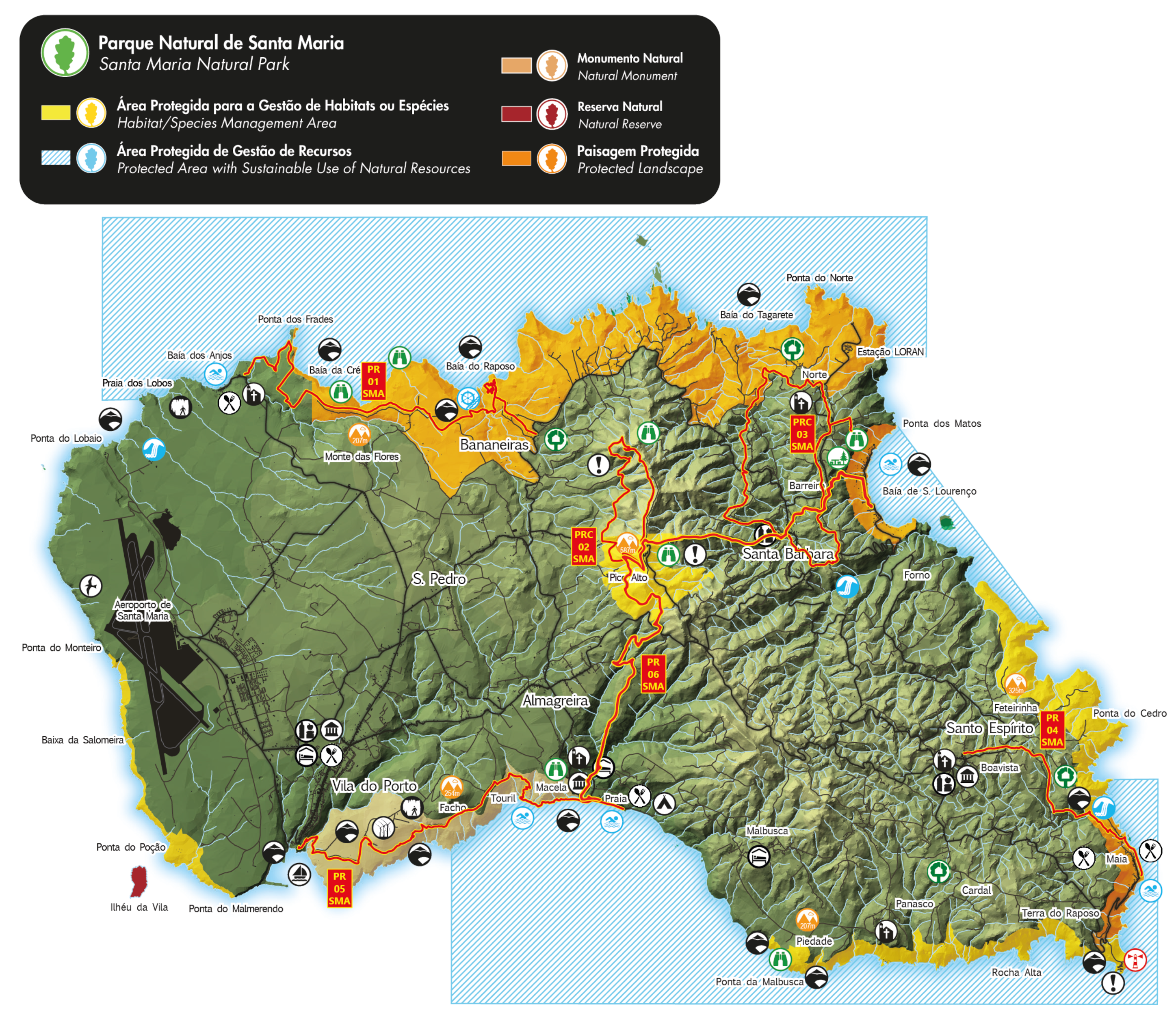
Santa Maria Natural Park, as shown in
Figure 1, is composed of different areas that are classified into two Natural Reserves, one Natural Monument, four Habitat/Species’ Management Areas, three Protected Landscape Areas, and three Protected Areas with Sustainable Use of Natural Resources. To better explore the island, there are six official trails and one great route that goes through some of the Natural Park areas, these being:
PR01SMA Costa Norte,
PRC02SMA Pico Alto,
PRC03SMA Entre a Serra e o Mar,
PR04SMA Santo Espírito-Maia,
PR05SMA Costa Sul,
PR06SMA Areia Branca and
GR01SMA Grande Rota de Santa Maria.
Currently, most of the information about the trails is available on posters and pamphlets (physical and online). These information posters are generally distributed at the beginning of the trails, but also near the main points of interest along each of them. The placards are often difficult to read and easily damaged, both by the sun and humidity and by people. Although these posters are easily accessible and no other means is required to access that information, they are not easy to maintain or update.
The main goal of this work [
1] is to develop and evaluate an application for mobile devices that provides the user with a more interactive and ludic experience through the use of Augmented Reality (AR), navigation assistance for visitors, and access to information that is easy to maintain and update. Thus, it is intended to expand and attract even more locals and visitors to the protected areas of the island and its specificities, as well as to new technologies and the various possibilities that they provide.
The use of Augmented Reality to enhance the interactive experience with the physical space represents the added value of this work, as it generates and increases curiosity about the points of interest of the island and about this technology, contributing to providing a richer experience. This paper describes the study conducted to develop and evaluate a mobile application to enrich the user experience by guiding visitors on hiking trails. The study is focused on the use of augmented reality technology as a way to interact with the environment.
The paper is structured as follows:
Section 2 discusses the related work;
Section 3 presents the analysis and methodology used;
Section 4 describes the development process;
Section 5 presents the evaluation of the mobile application and discusses its results;
Section 6 presents the conclusions and future work.
2. Related Work
The study described in this paper is related to works and approaches developed in different scopes like Navigation, Mobile Tour Guides, or Augmented Reality in tourism.
2.1. Navigation
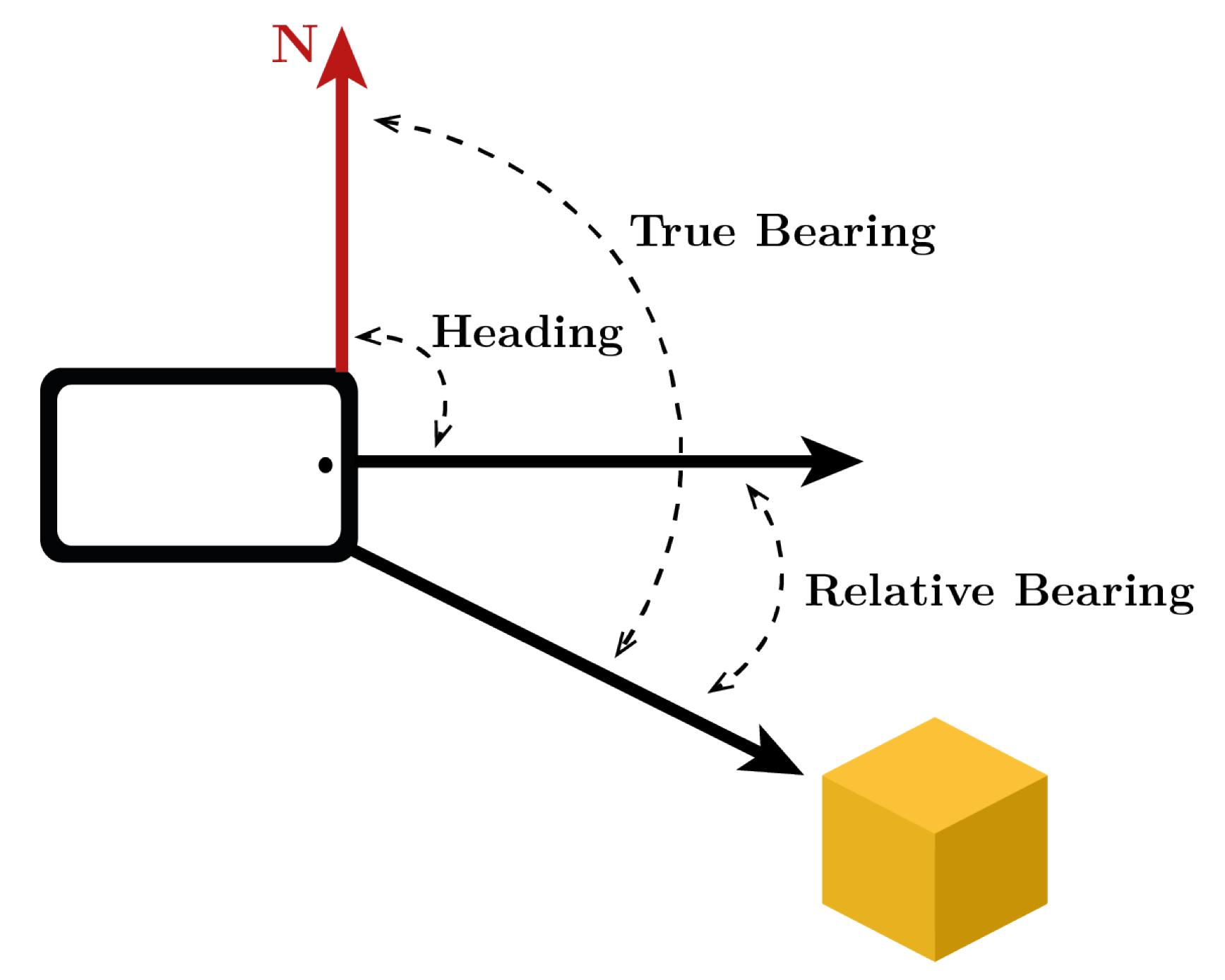
In general, mobile applications associated with hiking trails need to use concepts in the navigation field [
2] related to localization and orientation. To determine positions and distances, usually, they used Global Navigation Satellite System (GNSS) signals and the Haversine equation [
3,
4]. The diagram of
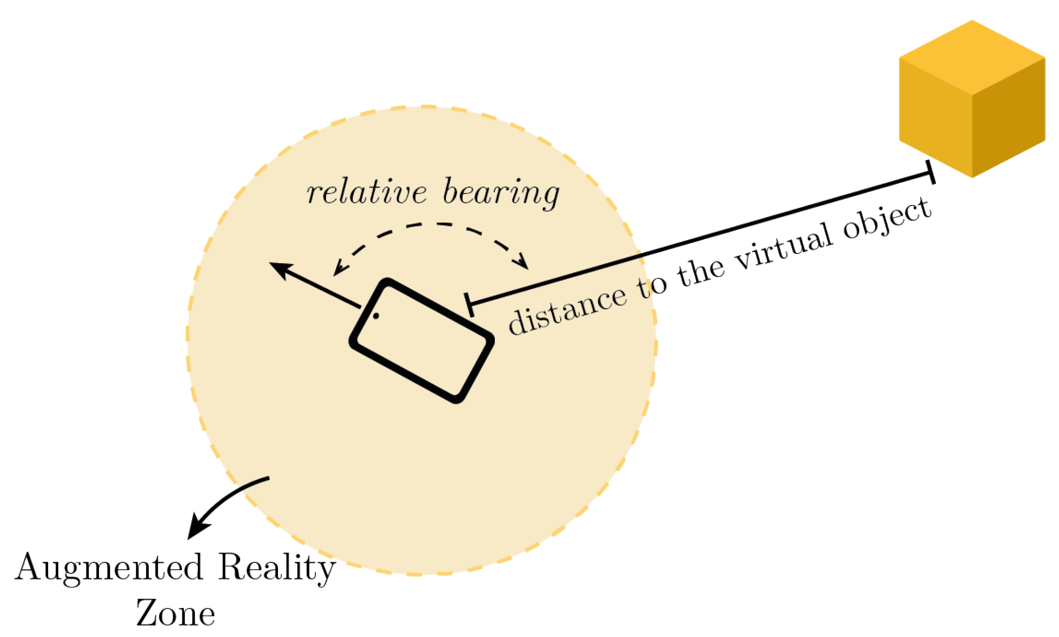
Figure 2 helps understand the terms used, such as heading, true bearing, and relative bearing [
5,
6].
The horizontal angle between the magnetic North and the direction of the device is called heading, and this is the angle indicated by the compass. True bearing represents the horizontal angle between the North and the line that links the device to a point of interest. Relative bearing represents the horizontal angle between the heading and the true bearing.
2.2. Mobile Tour Guides
The audio guides were the first ways to introduce multimedia content to the visitors’ experience [
7,
8]. Mobile tour guides replaced audio guides with the introduction of new mobile technologies in tourism. In general, these mobile tour guides should provide, fully or partially, four of these functionalities: navigation services, content-based services, communication/social services, and commercial services [
9].
Some studies have been carried out on the acceptance of mobile tourist guides by visitors [
10,
11,
12], demonstrating that the main factor that leads visitors to use this type of guide is the quality of the information available, as well as the type of experience they provide. In addition, they bring a degree of independence and flexibility to users that many traditional guides do not offer.
Regarding the usability of this type of tour guide applications, in [
13] a study is presented where it is possible to observe that the main measures of user experience in this type of scenario are: the quality of interaction between users and mobile guides (these should not be a barrier, but an extension); the ease of learning how to use and control the mobile guide; and overall usability (through the ability to convey more information about the points of interest/exhibitions and the enrichment of their experience).
The work published in [
14] presents an exhaustive study of various mobile tour guides, ranking them in terms of their development approach, availability, customization, usability, social aspect, and the type of evaluation used.
In [
15], a mobile guide is proposed for cultural heritage sites based on pictures. It presents information related to the place based on pictures and includes sharing features that help the visitor understand the place. One pioneer work including games in cultural heritage was proposed by Correia et al. [
16]. The goal of this work is to define and implement a platform for mobile storytelling, information access, and gaming activities that are evaluated in a cultural heritage site.
These mobile applications and other digital platforms are expected to enhance and improve the engagement and satisfaction of the tourists exploring cultural and heritage sites. Therefore, [
17] presents a location-aware mobile application that supports users’ exploration of sites of heritage and cultural value in Singapore, facilitating better navigation and digital socializing.
2.3. Augmented Reality
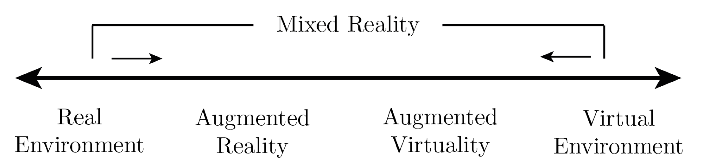
Milgram and Kishino [
18] describe the notion of a virtuality continuum (
Figure 3), where at one end are the totally real environments, and at the other end are the totally virtual environments (Virtual Reality). Mixed Reality is everything in between these two extremes and is the most general and broad term to describe the core area of the virtuality continuum.
To better define this gray area, two concepts were adopted that are distinguished by the “amount” of real environment present, that is, if the environment is predominantly real or virtual. Thus, in Augmented Reality, the real world is enhanced by virtual objects, and in Augmented Virtuality, real objects are integrated into the virtual environment. Ronald Azuma [
19] defines Augmented Reality as a system that combines real and virtual, is interactive in real-time, and registered in 3D. In this study, we follow this definition of AR.
One of the main challenges of AR is motion tracking and geo-localization [
20]. The success of this technology is based on the accuracy with which it is possible to establish the position and orientation of the camera in a three-dimensional space, the so-called pose. To do this, sensors such as accelerometer, gyroscope, compass, camera or GNSS data can be used to establish the pose with the best accuracy possible.
Depending on its application, there are several types of AR [
20,
21,
22]. It can be marker-based, by using fiducial marks or Natural Feature Tracking (NFT), or markerless, by using Simultaneous Localization and Mapping (SLAM).
The virtual object is placed in the scene according to its distance from the camera and with a certain rotation on itself. The calculation of this rotation is important to create an even more realistic experience for the user, since different views of the virtual object must be rendered depending on the user’s orientation.
Different solutions have been proposed for tourism using Augmented Reality [
23,
24]. Initially, the main problems for the widespread implementation of this type of technology were the lack of funding for equipment acquisition [
25], the interoperability between the platforms available for the development of this type of AR applications [
26], and the hardware resources needed [
27].
A pioneering study by Aluri [
28] investigated an existing mobile reality application with a gaming purpose (Pokemón Go) and examined the intentions to use it as a mobile travel guide in the future.
In [
29], the development of a guide with smart glasses is proposed that provides visitors with an outdoor museum with context-aware information regarding the points of interest in their field of view (using orientation and location functionalities). This smart glass-based guide is also compared with an identical smartphone-based application, concluding that the smart glasses offer a more seamless and private experience, while the smartphone offers a better group experience, due to the possibility of information sharing in its exposed display.
More recently, Grammatikopoulou and Grammalidis [
30] propose a self-guided tour tool with augmented reality and social features that enables information sharing and interactions between museum staff and visitors to create an online learning community.
Mobile platforms using Augmented Reality aim to provide users with a more fluid experience in which the obstruction of space by virtual objects is not evident and too intrusive [
31] and for that, an approach focused on the user and the purpose of the platform is often used [
32,
33].
Some existing and published mobile applications, such as SmartGuide [
34], PocketSights [
35], and AR Trails [
36], have similar objectives and functionalities as the proposed application. Our proposal is focused on the study of using an interaction model based on augmented reality to improve the user experience.
3. User Research
The work described in this paper proposes a way to explore relevant information in outdoor environments, making it possible to provide additional information that is easy to maintain and update. The main idea is to help the user navigate and observe the physical space using several sensors of the mobile device (including geolocation) and presenting information (including 3D content) in the form of Augmented Reality to enrich the user experience.
The domain of our study is the hiking trails on the island of Santa Maria. We started our study by performing a user research questionnaire to 77 users including residents and visitors of the island.
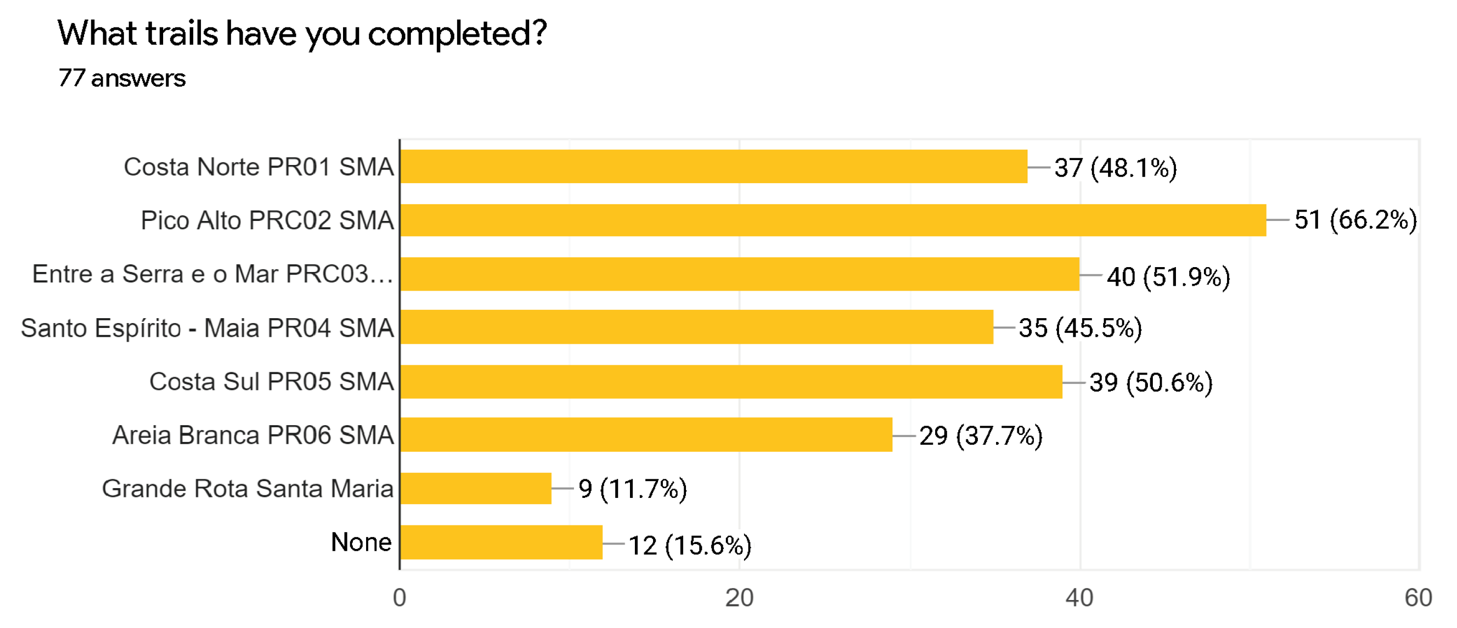
3.1. Analysis
In order to characterize the target audience and understand their needs, a questionnaire was conducted which counted 77 responses from residents (63–81.8%) and visitors (14–18.2%) of the island of Santa Maria. Of these, only 12 had never been on a trail, and the most popular trail was the
PRC02SMA Pico Alto (completed by 51 respondents), followed by the
PRC03SMA Entre a Serra e o Mar and
PR05SMA Costa Sul trails (completed by 40 and 39 respondents, respectively), as shown in the graph in
Figure 4.
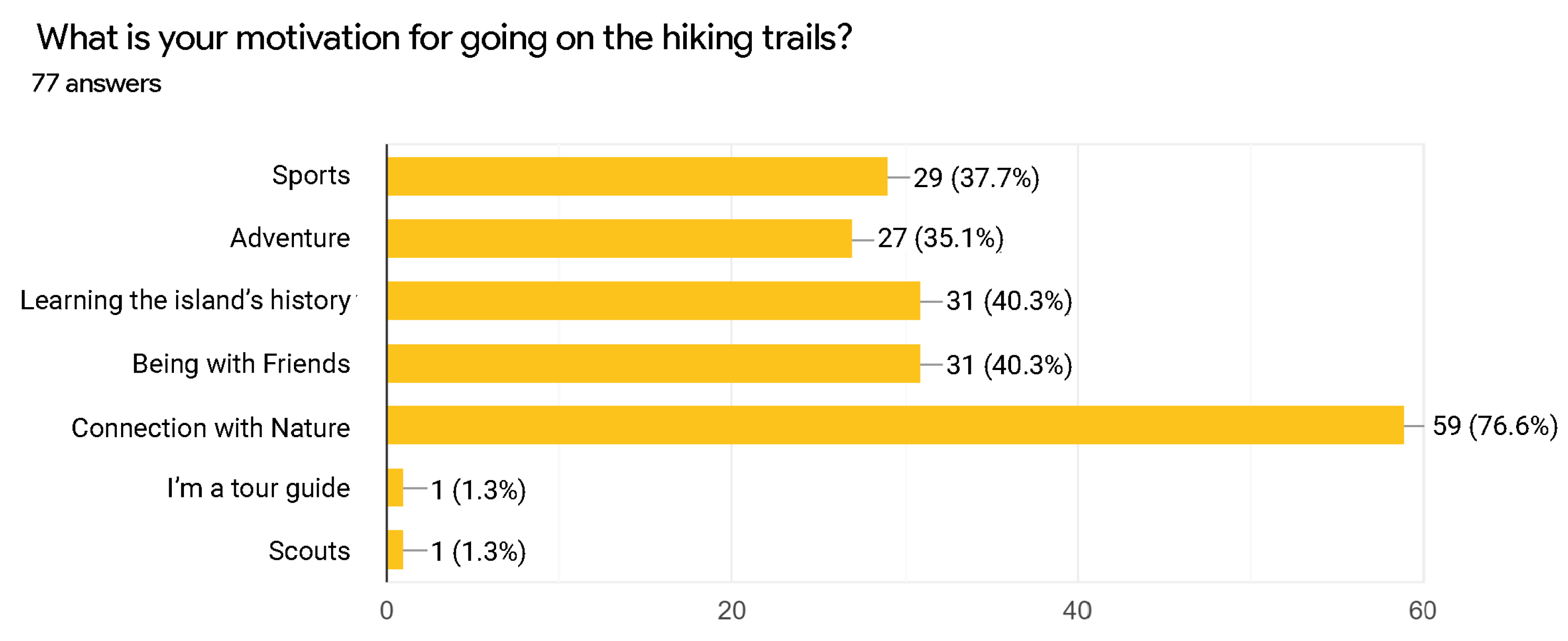
When asked about the frequency with which they hike, 40.3% reveal that they do it very rarely (about once a year), 26% rarely (about once a month), and 20.8% regularly (about once a week). According to the graph of
Figure 5, the major motivation for going on the trails is the connection with nature that they provide (76.6%); however, they also consider that it is important for them to know more about the history of the island and that this is a good way to spend time with friends (40.3% in both cases).
About 70% of those questioned consider that they do not have enough information about the island’s points of interest, and this is also the biggest difficulty revealed (pointed out by 41 of those questioned), as well as the orientation during the tours (pointed out by 29 respondents).
All the participants consider a mobile application to guide the hiking trails in Santa Maria useful, and 91% of them “agree” or “completely agree” that they would frequently use this application.
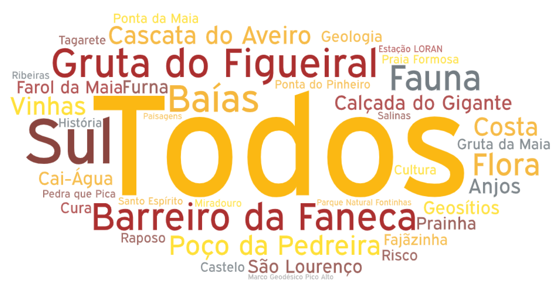
A word cloud (words in the Portuguese language) was created to illustrate the main points of interest mentioned by the participants (
Figure 6). In general, the participants think that all (“Todos”) the points of interest are important, but the most mentioned ones are “Gruta do Figueiral”, “Barreiro da Faneca”, and “Costa Sul”.
When asked about the technologies they would like to see in an application of this type, most mentioned “Navigation during the route (via GPS)” (62 respondents). Text and audio information about points of interest were mentioned by 46 and 30 participants, respectively, and “Augmented Reality” only by 16 of them. More users were expected to mention “Augmented Reality”, but this can be justified by some lack of knowledge of the technology. In a study presented later in this document, participants were curious about using this technology and mentioned that they enjoyed the experience.
3.2. Requirements and Use Cases
Based on the user research, the user tasks for the application were defined for two different roles:
User:
- –
Make the registration and authentication using three ways: (1) Anonymous, (2) Email and Password, and (3) Google account;
- –
View information about the trails: difficulty, duration, length, map, topography, main points of interest, and images;
- –
Start the navigation on a trail (with information about the distance traveled and time elapsed since the beginning of the trail);
- –
Enter the Augmented Reality mode when you are close enough to a point of interest;
- –
Save the completed trail (with information on distance traveled, duration, and points of interest visited along the way);
- –
View the previously completed trails;
- –
Delete previously completed trails.
Administrator
- –
Add points of interest to available trails;
- –
Delete points of interest from the available trails.
4. Development of the Mobile Application
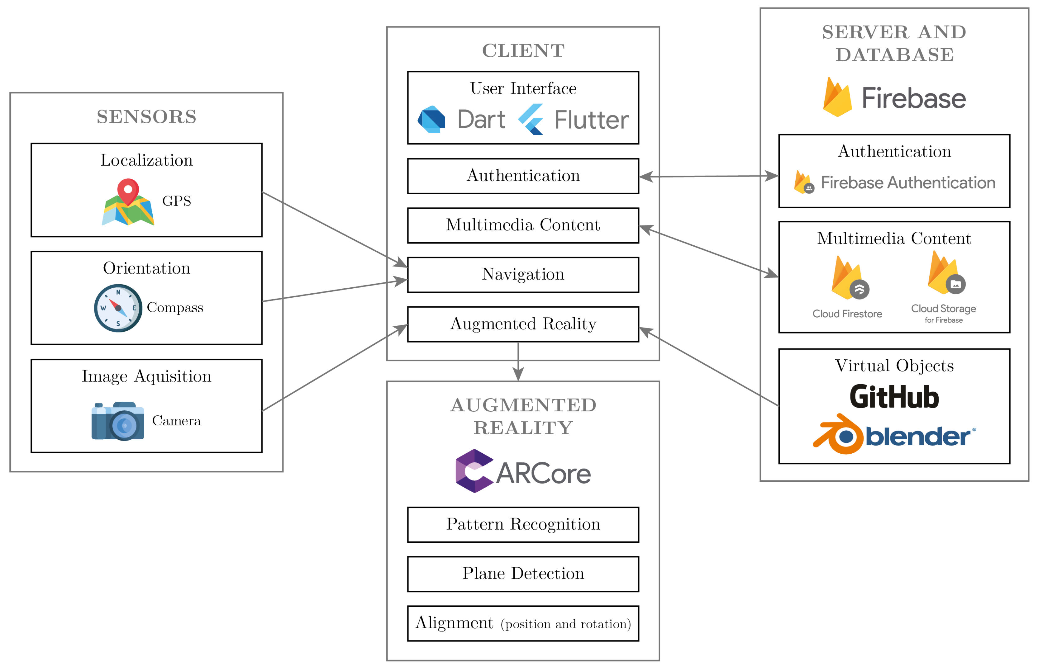
To implement the system, in the first phase, the concept phase, a study of the technologies available to be used is performed to select the more suitable technologies to use. In the second phase, the construction phase, the architecture of the system is translated into Dart/Flutter code and the application is fully implemented.
4.1. Functional Architecture
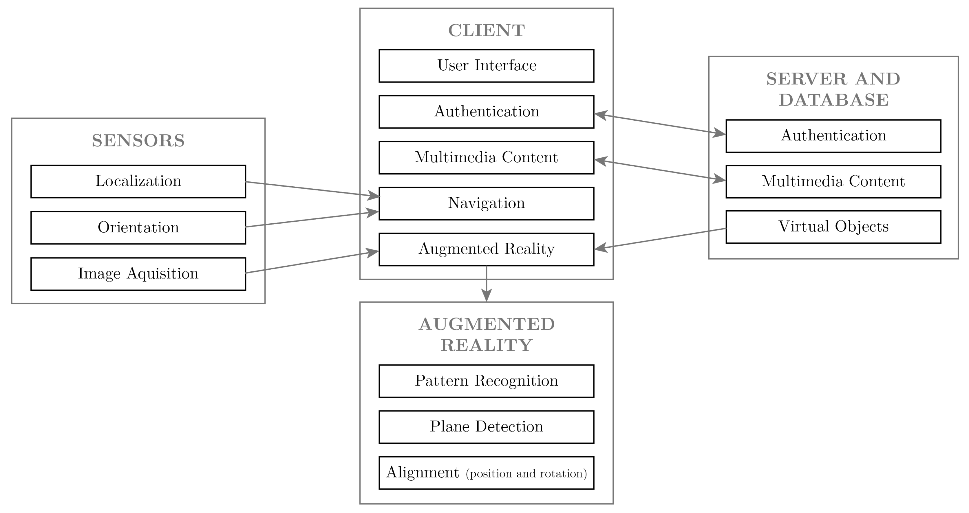
To meet these requirements, a system based on a client-server architecture (including services in external clouds) was implemented.
This system consists of a mobile application (
Client) that includes two main modules (
Navigation and
Augmented Reality) with the functionalities defined previously (
Section 3.2), depending on the type of user. To do this, it is necessary to access the
Sensors available on the smartphone, as well as a set of tools available to implement the Augmented Reality component.
The user will perform the Authentication on the mobile phone but all the logic process is conducted in the backend (
Server and
Database), which also includes the storage of multimedia information (text, images, and virtual objects). The diagram in
Figure 7 illustrates the architecture of the application.
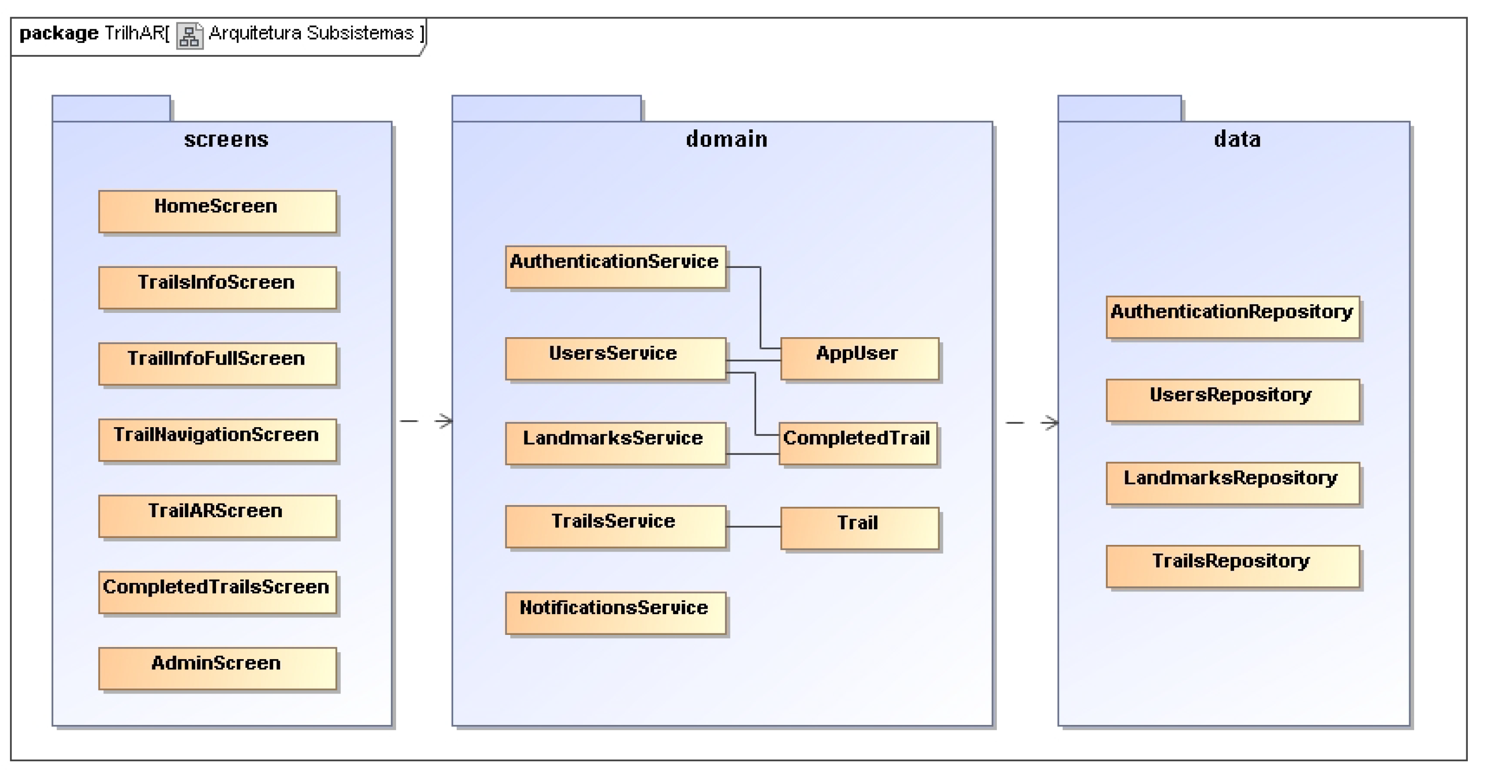
The application is implemented following a 3-Layer Logical Architecture as the architecture pattern, where the subsystems are divided into three layers: Presentation, Domain, and Data Access (
Figure 8). The mobile application consists of seven main screens, each one being responsible for one main functionality. The following sections explain the principal screens as well as the related logic.
4.2. Technological Architecture
In the process of choosing the technologies, research was conducted in order to understand which are the most widely used technologies and which best meet the objectives of this project.
Three leading technologies/frameworks were analyzed for the development of the mobile application: Ionic, React Native, and Flutter. The first two are the oldest and best known and the last one is a newer technology with higher popularity [
37,
38].
Flutter was chosen for the development of the application since it is multiplatform and has proven to be a powerful technology with advantages for this type of project, including the fact that it is natively compiled, increasing its performance when compared to other frameworks [
39].
The application developed in this work has some degree of relationship between the data, but implementing a relational database in such a project is not justified. Therefore, it was decided to use Firebase, a Backend as a Service (BaaS) platform from Google, for the development of mobile and web applications, which, among other services, provides authentication (Firebase Authentication), a non-relational database that allows you to store a larger amount of data and make it available in real-time to all users (Firebase Cloud Firestore), and a cloud storage service can store images, videos, and audio, among other types of files (Firebase Cloud Storage).
Although Firebase has a cloud storage service, it is based on absolute paths, which makes it very difficult to access and handle the virtual objects on this platform. Thus, GitHub was used as a Content Delivery Network (CDN), i.e., a distribution network that enables faster content delivery to a larger number of users. In addition, GitHub is based on relative paths, a fundamental aspect in the handling of the referenced files in the virtual objects. The virtual object were modeled and manipulated using Blender.
The selection of Flutter for the development of the mobile application narrowed down the choice of platform to integrate Augmented Reality. Thus, ARCore was chosen, since it is multiplatform and there is already a compatible plugin developed for integration with Flutter. However, the documentation regarding this plugin is limited, and not all the features provided by ARCore are implemented, which limited the development of some of the functionalities of this work.
Figure 9 shows the architecture of the application with the associated technological dependencies chosen.
Figma was the tool used to create the mockups and the non-implemented prototype of the mobile application.
4.3. Trail Information
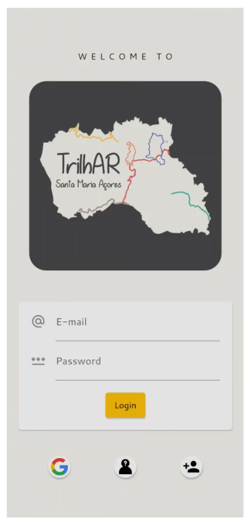
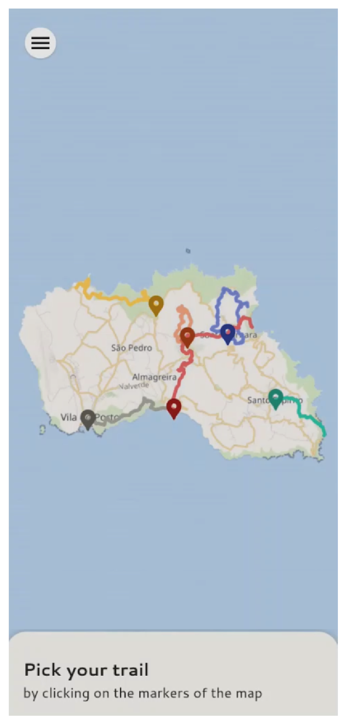
The launching screen (
HomeScreen) is shown in
Figure 10, where the authentication options are provided, including the registration, shown in
Figure 11. After that, the users are redirected to the screen shown in
Figure 12 (
TrailsInfoScreen). A trail can be chosen by clicking on the markers on the map.
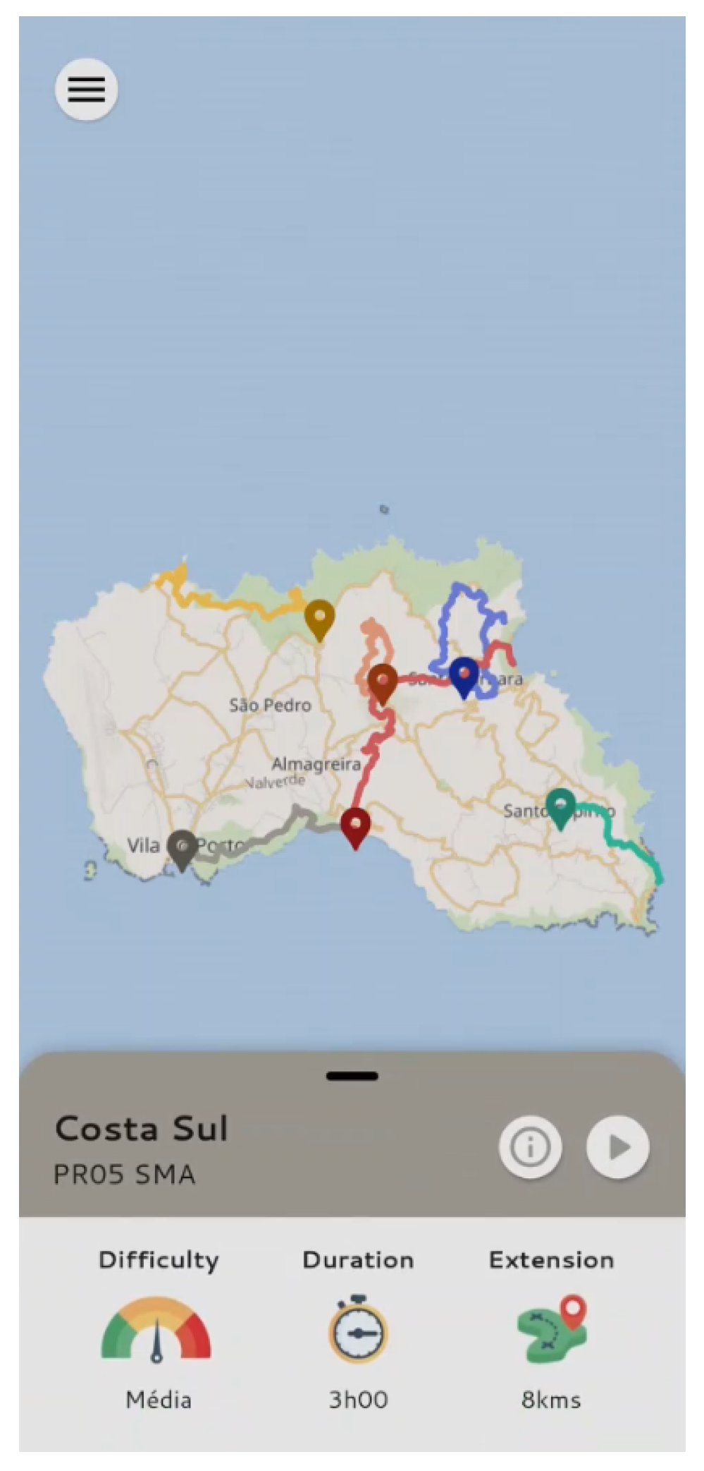
Selecting a trail allows the user to observe some basic information about it in the sliding panel shown in
Figure 13, such as the difficulty, duration, and length of the trail.
By clicking on the information button
![Mti 07 00058 i001]()
in
Figure 13, the user is redirected to the screen shown in
Figure 14 (
TrailInfoFullScreen). On this screen, more details about the hiking trail are available: map, topography, main points of interest, and images.
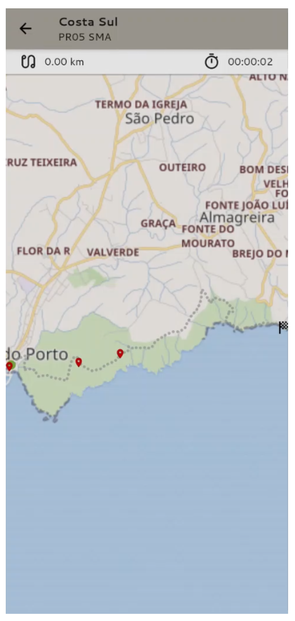
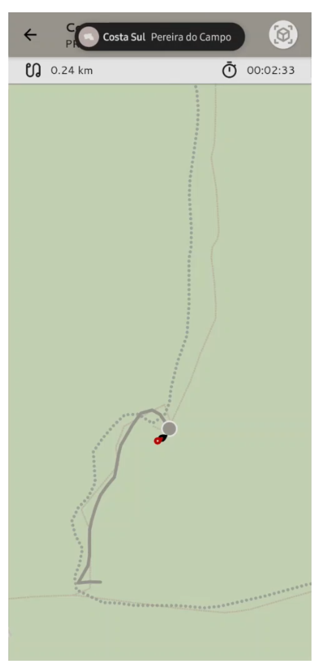
4.4. Navigation
To start the hike, the user must click the play button
![Mti 07 00058 i002]()
in
Figure 13 or
Figure 14. The user is then redirected to a new screen (
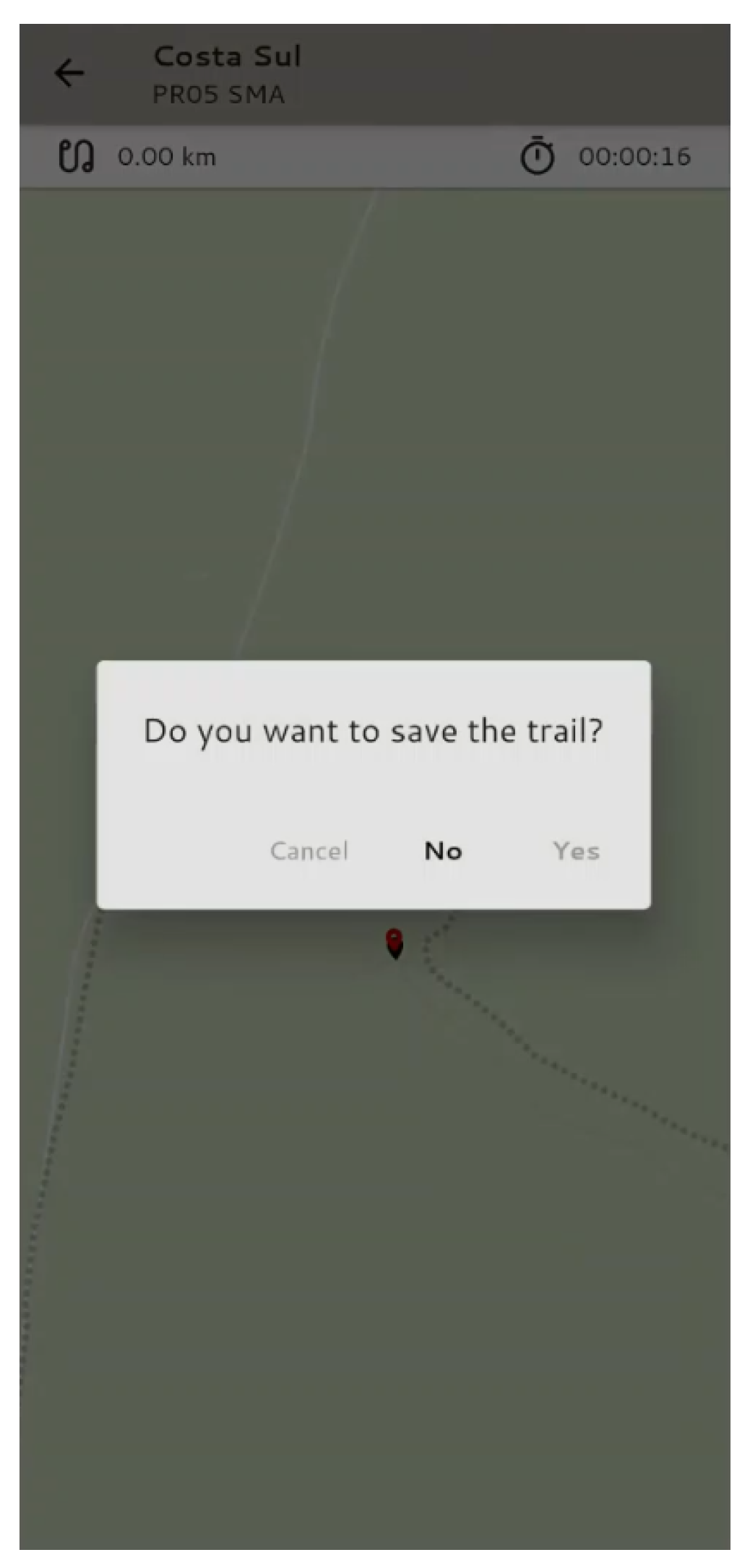
TrailNavigationScreen), where the route is marked as well as the points of interest along the way. It is also possible to observe the distance, the time elapsed, and the current position of the user, allowing the user to understand if he is following the right path (
Figure 15). When the trail is completed, there is a possibility to save the completed trail for future reference (
Figure 16).
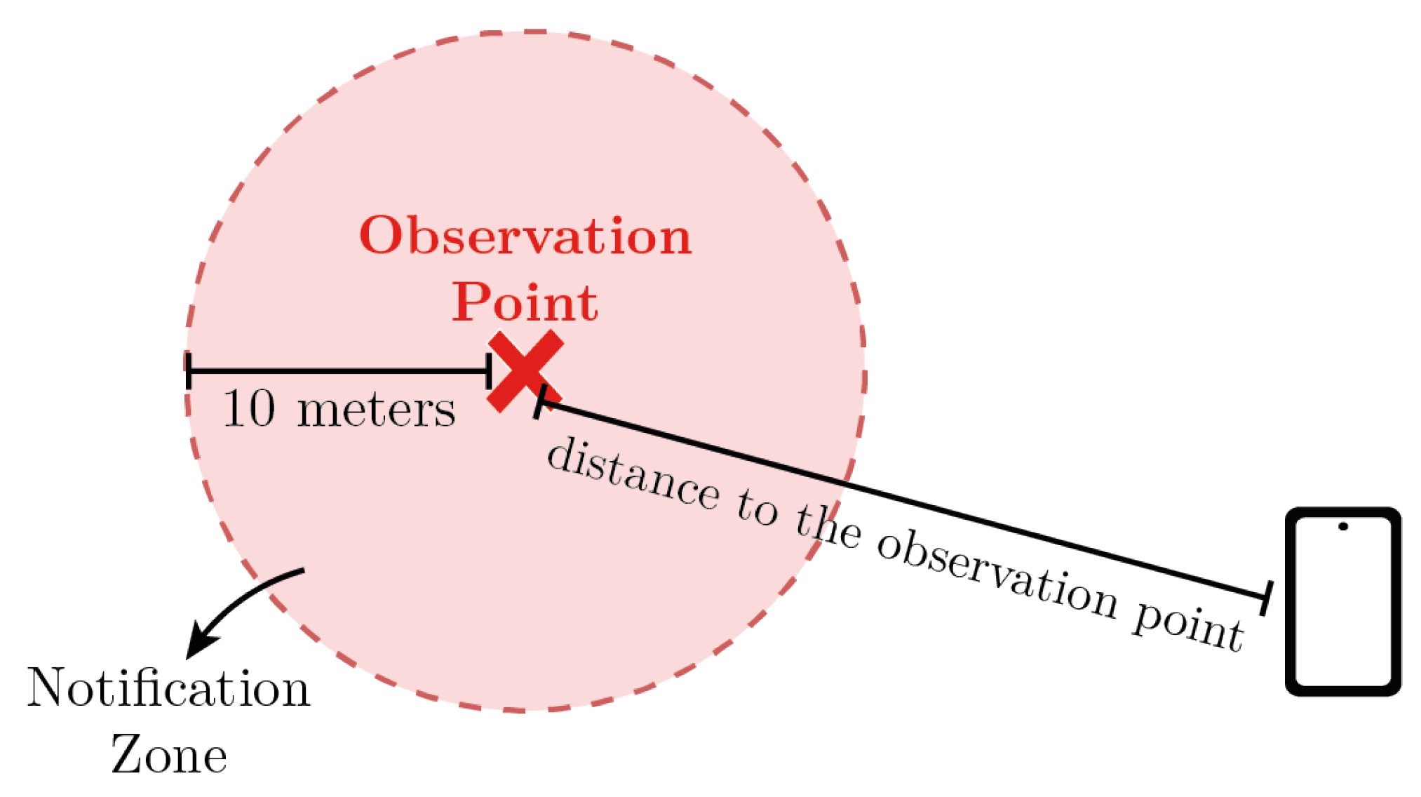
Notifications
To ensure the safety of the visitor, it is important that they stay focused on the hiking trail instead of constantly looking at their smartphone. Thus, a local notification system was implemented to make sure the user is alerted only when they are close to a point of interest ahead (10 m). The diagram in
Figure 17 helps explain the triggering of the notification system.
4.5. Augmented Reality
By clicking on the local notification (
Figure 18) or the AR button
![Mti 07 00058 i003]()
, the user is redirected to a new screen (
TrailARScreen), where the Augmented Reality component is implemented. Two possible views can be presented: Compass View (
COMPASS_VIEW) and AR View (
AR_VIEW).
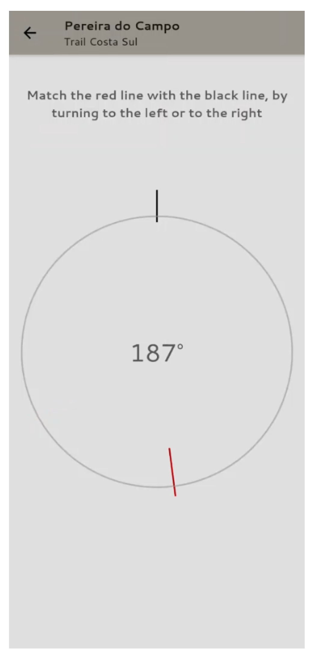
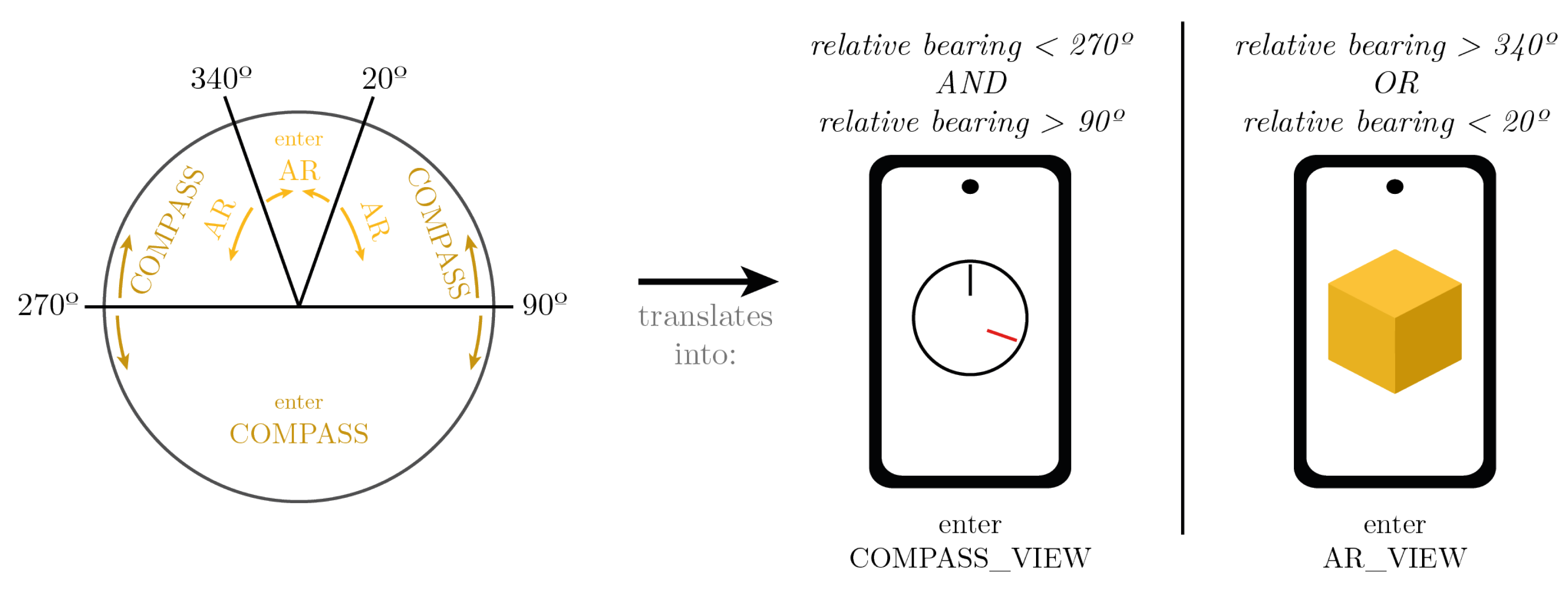
In the first case (
COMPASS_VIEW), it is assumed the user is not turned in the direction of the virtual object (the relative bearing is outside of an interval, see
Figure 19); therefore, the information on the screen (
Figure 20) indicates that the visitor needs to turn around (making sure the red line matches the black one) so that the user is in the right orientation to see the object.
In the second case (AR_VIEW), the user is turned in the right direction, the augmented reality process starts.
The process starts with the Compass View (COMPASS_VIEW) and consulting the smartphone’s compass. Thus, it is possible to understand whether the user is headed to the place where the virtual object was previously registered or not. The change from COMPASS_VIEW to AR_VIEW is performed based on the orientation of the device relative to the point of interest. It was considered that from a device orientation of less than ±20° (340° to 20°), the application should change to AR_VIEW. However, when the application is in AR_VIEW, this range is increased to avoid instabilities caused by the systematic change of views, that is, the range varies according to the view the application is in (hysteresis).
Figure 21 shows a diagram that represents the entry conditions in each of the views (taking into account only the orientation of the device).
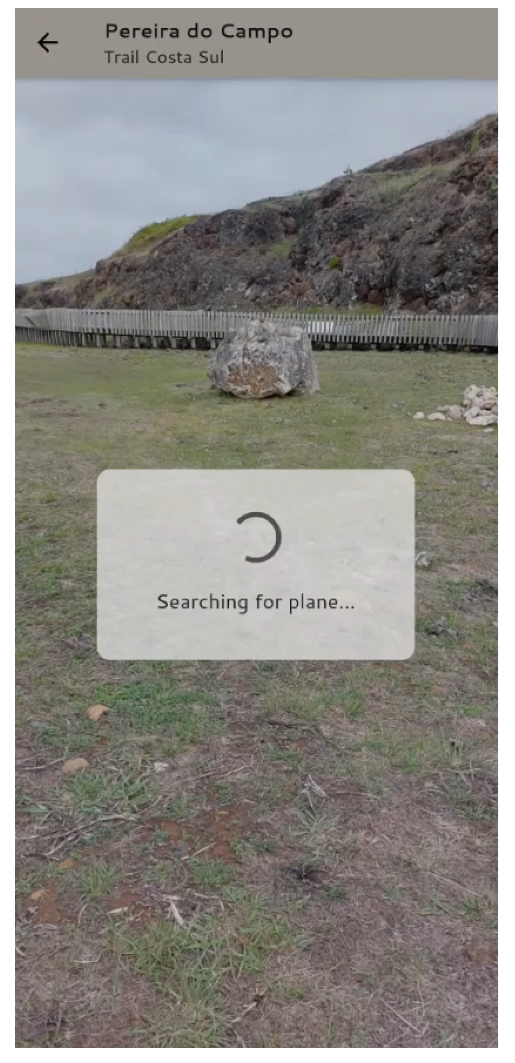
When the application enters the AR_VIEW, a plane is detected in the environment captured by the smartphone’s camera (using ARCore’s SLAM) and after that, the rendering of the virtual objects starts.
In order to make sure the object is well aligned with the view of the smartphone’s camera, a few calculations (specified in
Section 2.1) need to be conducted, regarding the position and rotation of the virtual object itself.
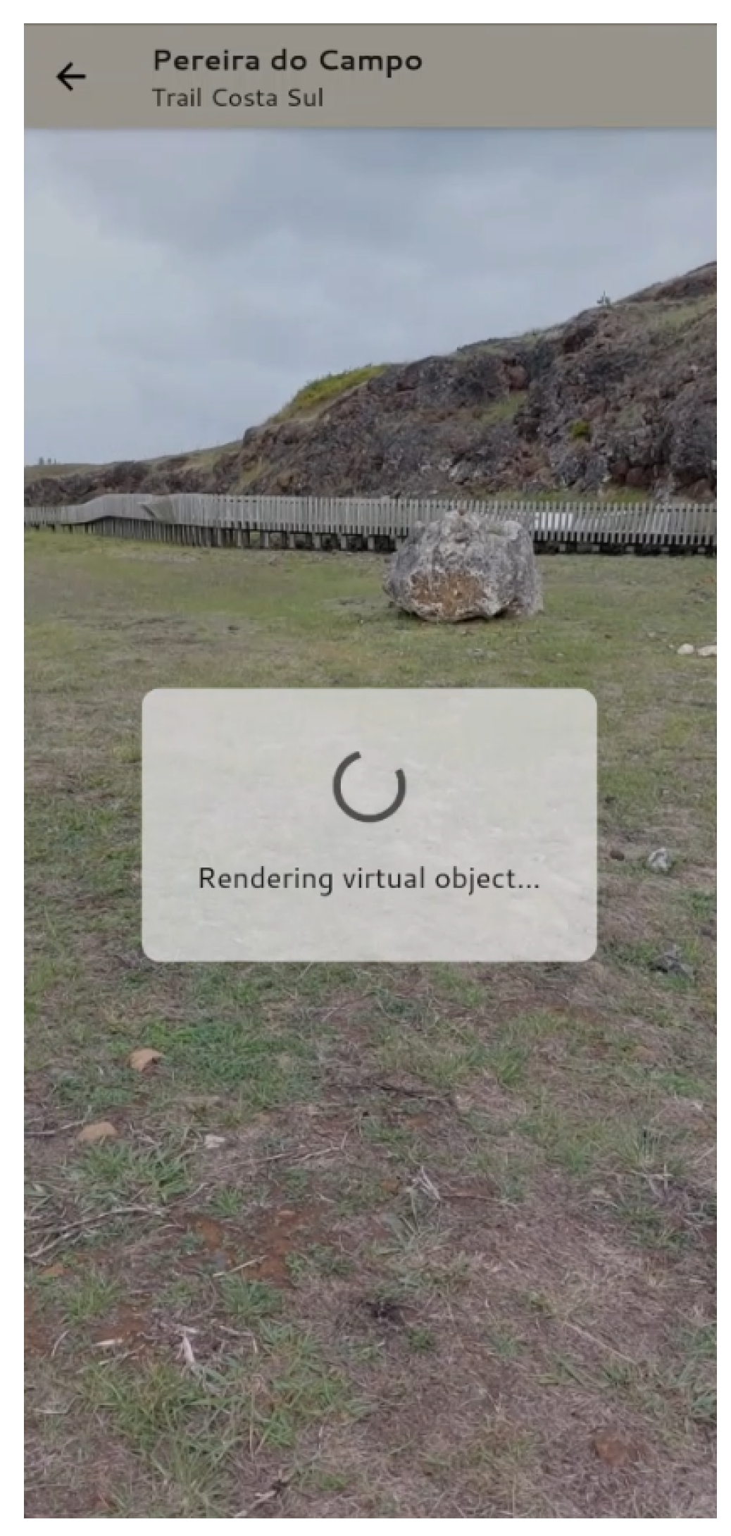
The user is constantly being informed of the process that is happening at the moment, as shown in
Figure 22 and
Figure 23.
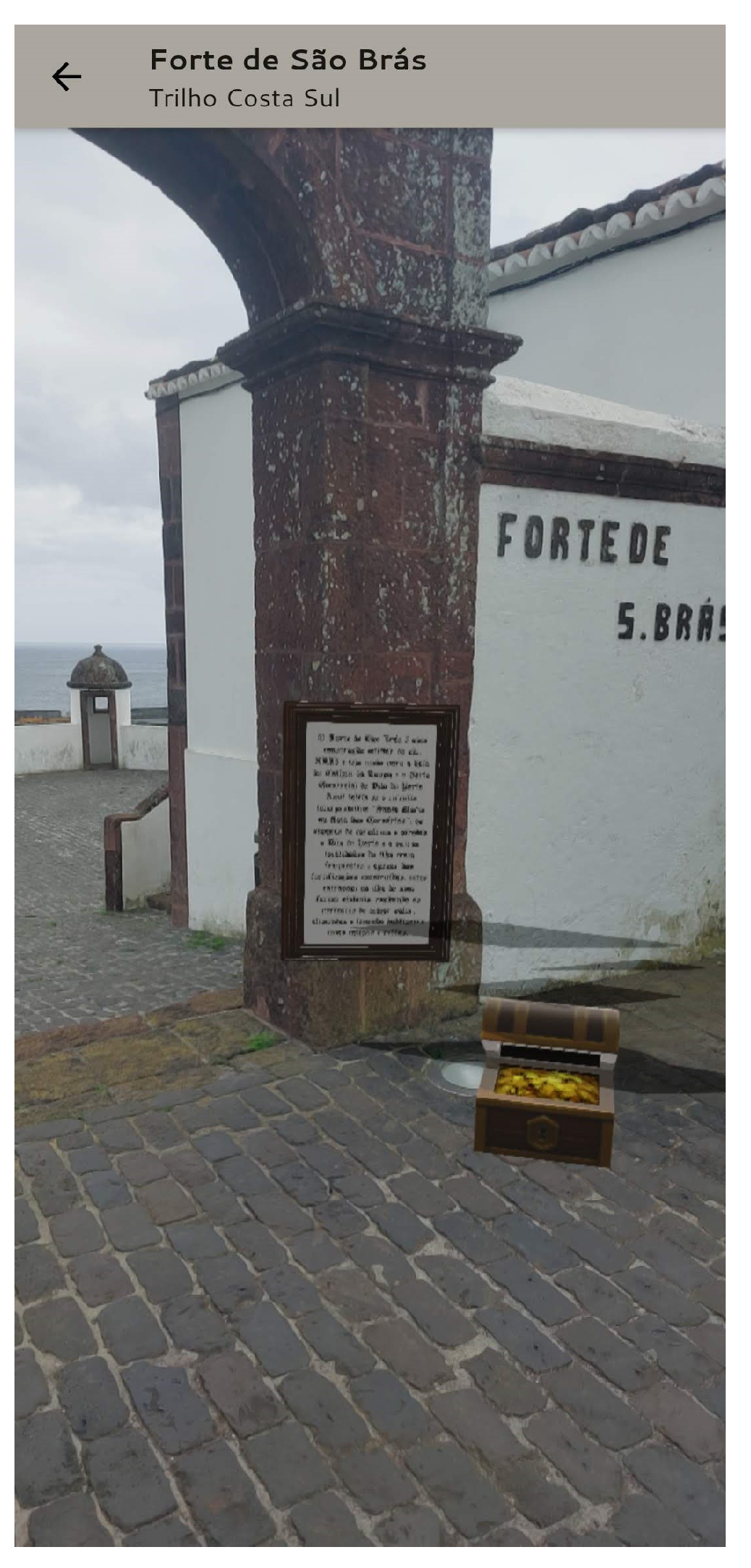
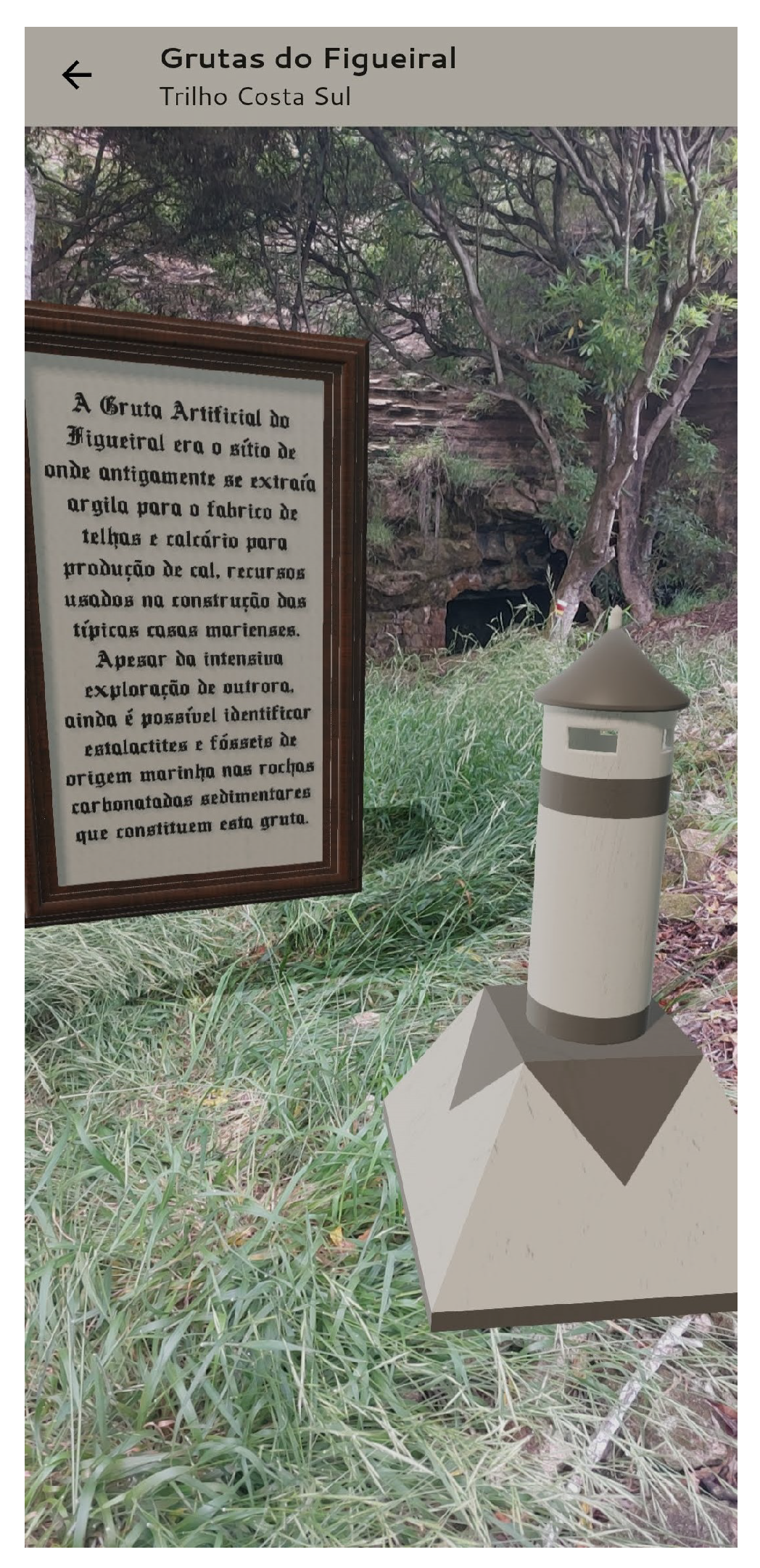
Figure 24,
Figure 25 and
Figure 26 show examples of the virtual objects present in one of the trails. The virtual object consists of the 3D model of an object allusive to the physical place and a placard with informative and concise text.
4.6. Completed Trails
After finishing a trail and saving it, the user can observe on the respective page (CompletedTrailsScreen) the previously completed trails sorted from the most recent to the oldest, with information about the name of the trail, the starting date and time, the time taken to complete the trail and the points of interest visited. It is also possible to delete the trails using the swipe movement.
4.7. Administrator/Points of Interest
Before having access to all the Augmented Reality experiences provided by the mobile application, the administrator needs to add the points of interest to the respective hiking trails (AdminScreen). To perform this, the administrator must go to the respective location and determine the direction in which the object should be placed (by using the corresponding functionality of the proposed application and pointing the smartphone in the desired orientation). It is also necessary to define the name and determine how far the virtual object should be from the current observation point (by inputing the distance manually). It is possible to delete the points of interest by using the swipe movement.
5. Evaluation and Discussion
The evaluation of the mobile application is mainly focused on the evaluation of the user experience promoted by the interaction process based on the augmented reality component. This also includes the assessment of certain performance criteria that can influence the augmented reality component. The experiments were conducted in a real context with users belonging to the audience on-site, in Santa Maria island, Azores.
The tests were carried out individually by each participant using their own smartphone. The hiking trail chosen for the field tests was PR05SMA Costa Sul. The participants were briefed about the goals of the tests and told to follow the questionnaire provided by the supervisor. The supervisor took notes and recorded problems/suggestions explicitly mentioned by the participants.
The questionnaire is divided into six main sections: (1) Application setup, (2) user characterization, (3) before starting the trail, (4) during the trail, (5) after the trail, and (6) overall evaluation of the application. Participants should answer the first two sections before starting to test the application.
Section 3-5 should be followed and answered by participants while testing the application, and
Section 6 should be answered after testing the application.
The questionnaire is mainly composed of multiple-choice questions. There are also open questions that allow the participant to write errors, suggestions, or comments. System Usability Scale (SUS) [
40] questions and the User Experience Questionnaire (UEQ) [
41] are also included in
Section 6 of the questionnaire used.
5.1. Participants
The tests were performed by 10 participants living on Santa Maria island and mostly with ages between 26 and 40 years old. The first contact of the participants with the mobile application was during the experiment.
Most of the participants use their smartphones from 1 to 5 h a day, mostly to communicate and access social media networks. Only two of the participants frequently use mobile applications for monitoring their hiking trails. Nine in ten participants use Samsung smartphones, with one being Huawei.
5.2. Performance
Performance tests were carried out to understand the location system’s accuracy and calculate the error inherent to this approach, how the smartphone’s battery is influenced by the use of the mobile application, and also the rendering time of the virtual objects.
Most of the performance tests were conducted in a more controlled environment with the smartphone Samsung Galaxy A52s 5G (2021), 256 GB 8 GB RAM, CPU Snapdragon 778 G, a battery of 4500 mAh with an accelerometer, gyroscope, compass, proximity sensor, and camera.
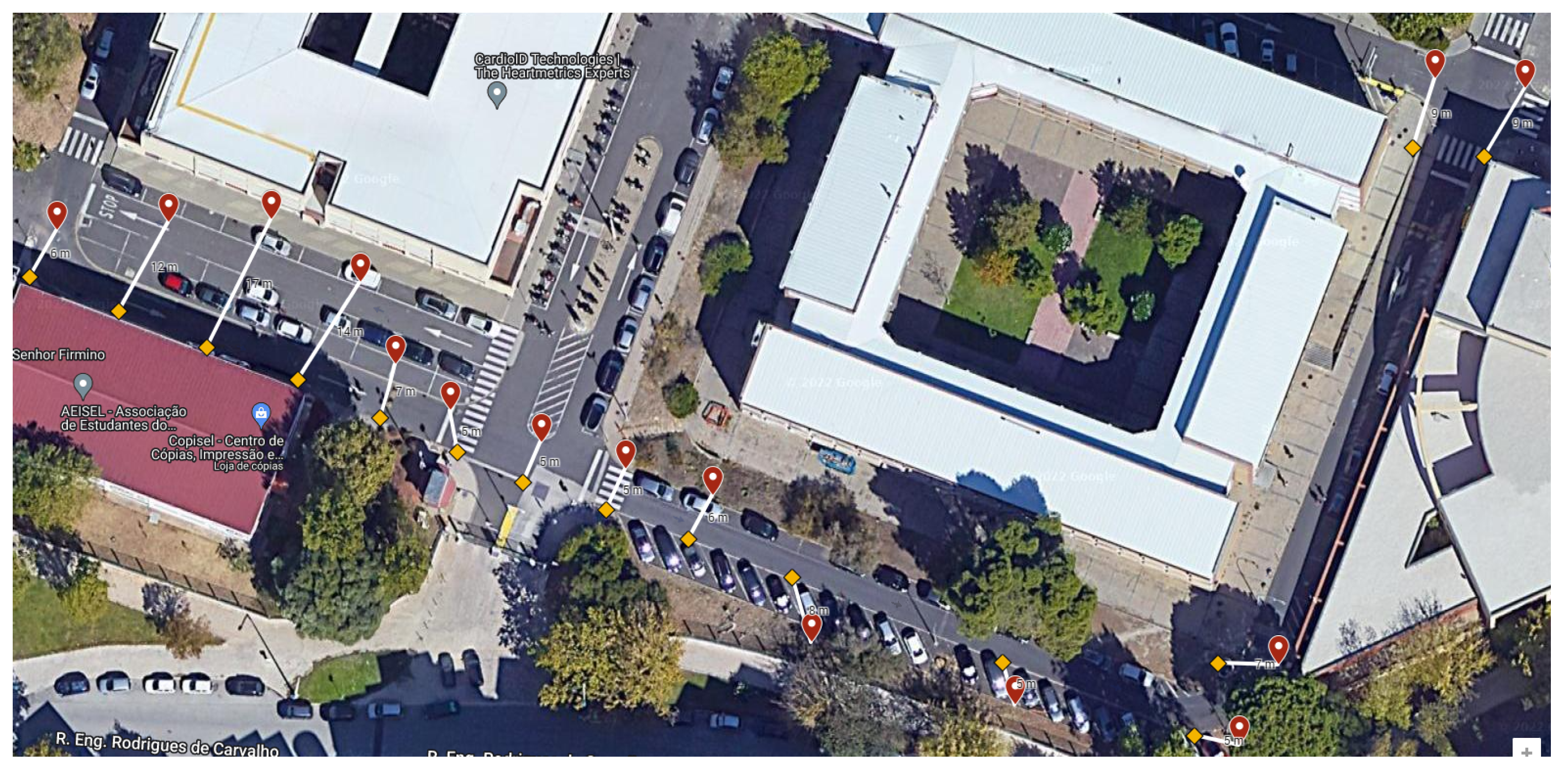
The GPS accuracy was tested in a controlled route inside the campus of the Lisbon School of Engineering (ISEL), as illustrated in
Figure 27, where the real position (yellow symbol) and the one indicated in the mobile application location system (red symbol) was marked. By calculating the distance between both locations, an average error of 8 m was obtained. These results were not obtained on Santa Maria Island. This means the average error can be slightly different. These preliminary experiments were made to verify whether the location error is relevant enough, in terms of the user experience.
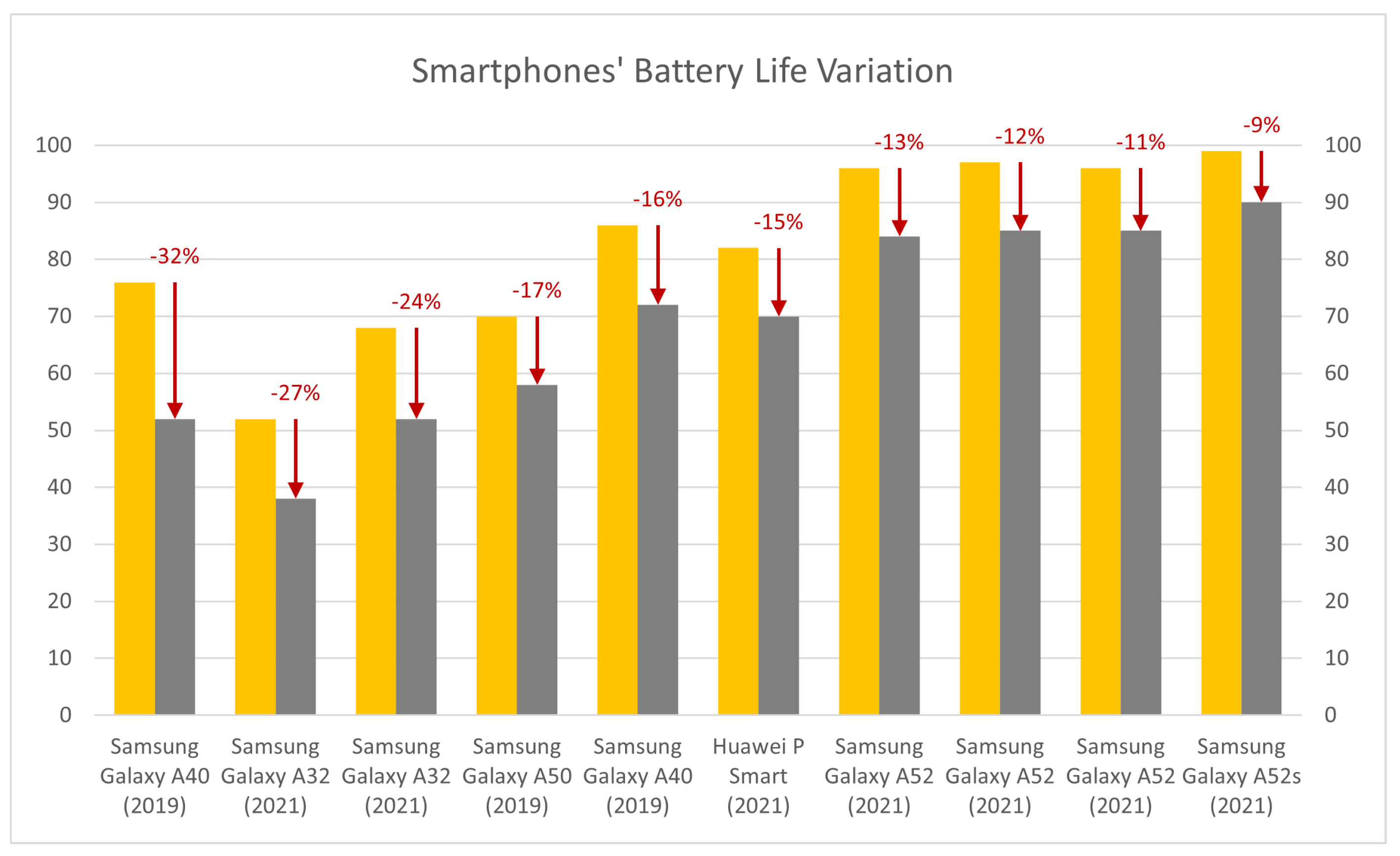
In order to test the battery life with different types of smartphones, users were asked to indicate the battery value at the beginning and end of the hiking route. After analyzing the data obtained, the average battery consumed during the tests was 13.6%. In the graph of
Figure 28, it can be observed that, for the most part, older devices have a higher battery drain than newer devices.
Since it is not possible to concretely measure how long each object takes to render for each user, the participants were asked for their opinion on how they felt the waiting time was. By their responses, it can be concluded the users felt that the rendering time was slow for the first object, however, the waiting time for the remaining objects decreased or remained the same.
However, when asked which objects they were able to observe, only 6 of the 10 users were able to visualize the last object on their smartphone (traditional chimney). It is possible to understand that it happened on smartphones with less processing power and RAM. This fact is also due to the decrease and sometimes complete lack of a mobile network in the place where this virtual object was positioned, making it impossible to download the information.
5.3. Usability
Section 6 of the questionnaire, besides the SUS, also includes a set of specific questions to measure the usability of the application. When analyzing the answers, in general, the results were very positive, as they considered the application to be simple, intuitive, and aesthetically appealing.
SUS is a standard questionnaire used to evaluate the overall usability of the application. It consists of ten questions with five response options (from “I strongly agree” to “I strongly disagree”) and is a very easy-to-perform questionnaire, valid even for small user samples.
After calculating the SUS score of each questionnaire, the average of the results is calculated. Thus, according to the participants, this application has a SUS score of 83, getting a rating of B (Excellent) on the scale used by the SUS [
42].
5.4. User Experience
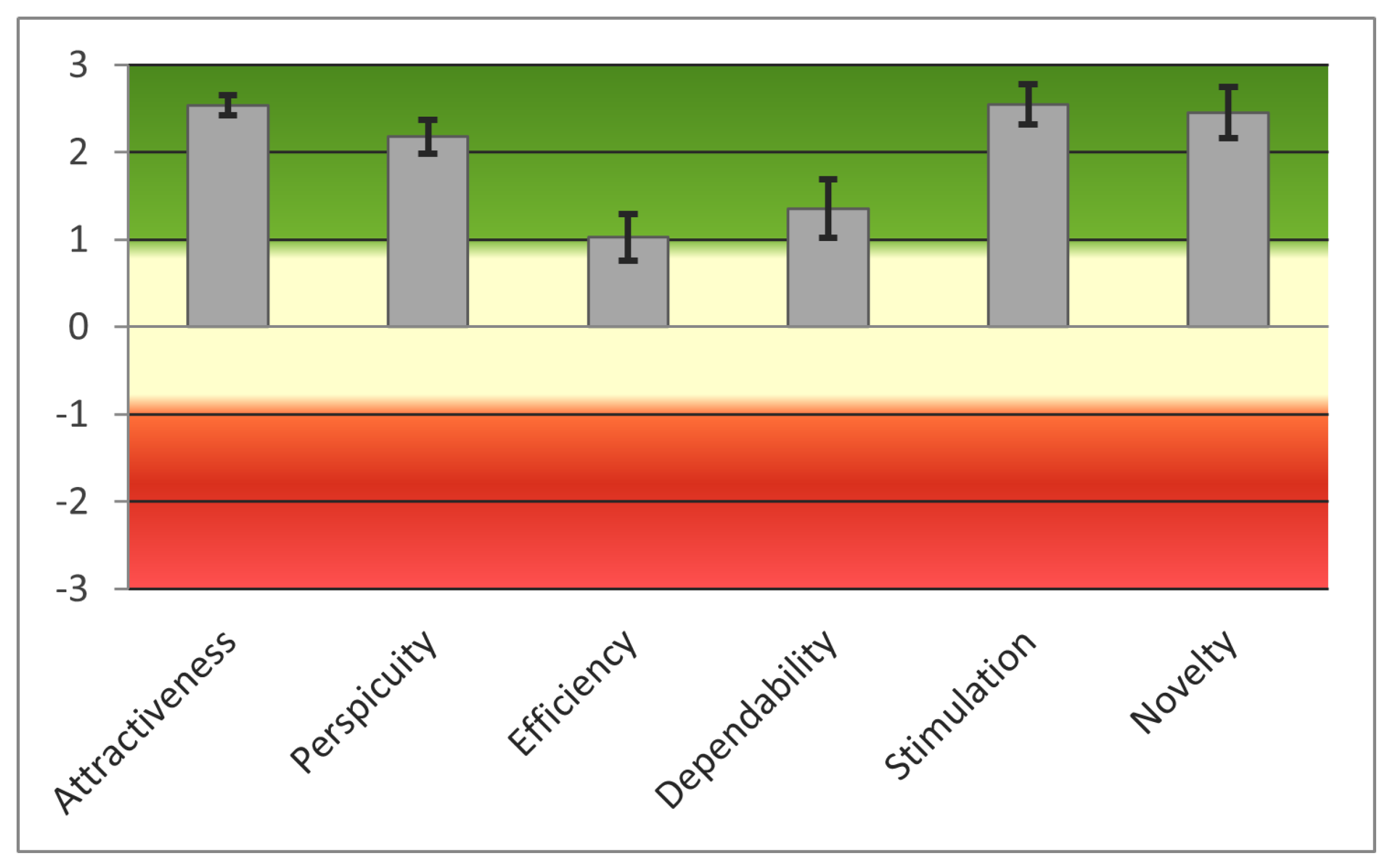
UEQ is used to evaluate the user experience, and it consists of 26 pairs of opposite adjectives related to the properties of the application. It is intended to be answered as spontaneously as possible since immediate evaluation is the most important thing for this type of questionnaire. Using this procedure, the mobile application is evaluated according to six parameters: Attractiveness, Perspicuity, Efficiency, Dependability, Stimulation, and Novelty.
The average results for each of the UEQ evaluation parameters (vertical bars), as well as their variance (black lines on top of the vertical bars), can be observed in
Figure 29. The parameters where the worst results were obtained are efficiency and dependability. By analyzing the pairs of opposites corresponding to these categories, it can be observed that most users considered the product slow and unpredictable. When questioning the participants that expressed this opinion, it was determined that the application was slow because of the rendering time of the virtual objects and that the notion of the unpredictability considered was not related to the control of the application, but to the fact that the application itself was innovative and unexpected.
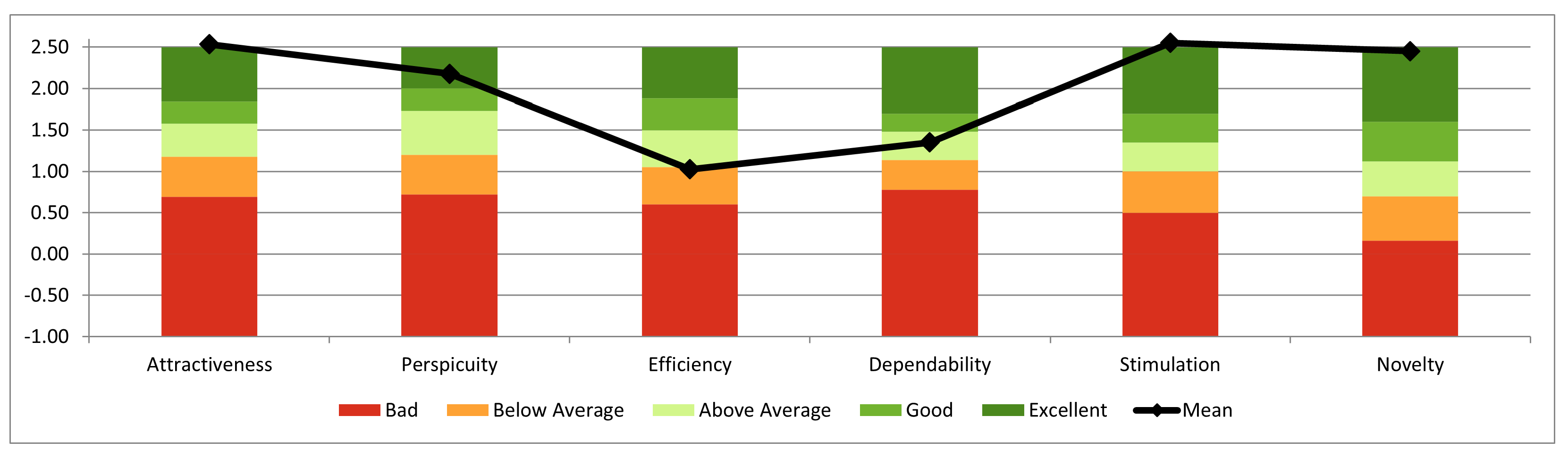
The results obtained in the evaluation of this mobile application were compared with the benchmark data provided in the Data Analysis Tool [
43] (containing information on 468 studies with a total participation of 21,175 people). When comparing the data (
Figure 30), it is possible to verify that regarding attractiveness, transparency, stimulation, and innovation, the results were excellent as compared to the top 10%. However, regarding efficiency, the result was below average, and regarding control, the result was above average.
5.5. User’s Opinions
Most users revealed that they had never used Augmented Reality applications on their smartphone before and the integration with the island’s hiking trails was very interesting. It also increased their curiosity about the technology itself and its different applications. In addition, they also considered it a good feature to send the notification near the point of interest to draw the attention of visitors. As for the objects presented, most of them liked them, but they liked the object that was modeled especially for this purpose (
Figure 31) even more, since it better fits with the place and represents the island of Santa Maria. In this experiment, the application used a set of general 3D objects obtained in the free assets store and a specific 3D object for the Santa Maria Island created in the scope of this work. In the future, it is planned to create more specific 3D models to enrich the visit to the island of Santa Maria.
6. Conclusions and Future Work
Tourism on the island of Santa Maria, Azores, has been increasing due to its characteristics in terms of biodiversity and geodiversity. This island has several official hiking trails and the information available can be found on placards or physical and online pamphlets.
Augmented Reality in the tourism sector brings even more interactivity to the already well-known mobile tourist guides. By conducting a study among the target audience, it is possible to understand that their curiosity about Augmented Reality is still low, however, navigation using GPS would be an added value pointed out by most of the respondents.
During the course of this project, it was possible to study and develop a mobile platform to monitor the walking trails of Santa Maria Island, Azores. This provides visitors with a more interactive and recreational experience through Augmented Reality, helps in navigation during the route, and provides updated information and easy maintenance.
The development of the mobile platform using Flutter brings great added value to the continuation of this project since it is a cross-platform technology, that is, the same code can be used in different mobile operating systems. The fact that it is a natively compiled language increases its performance on the smartphone.
The use of Augmented Reality to provide information to users generated great curiosity among the locals who participated in the evaluation tests carried out on the island of Santa Maria. Most of the participants revealed that they had never used AR on their smartphones before and were generally enthusiastic about their experience using the developed mobile application.
Although the proof of concept was successful, this application can always be improved by integrating new features and taking into account the suggestions of the participants in the evaluation. Thus, adding more trails and routes on the island and information (textual and audio on the AR side) about them would be the first step to extending the reach of this application. This information would be added as a new functionality of the administrator role. In addition, the possibility of downloading a priori information about the trail would be an added value in a way that there is no constant need to connect to the internet to acquire the information, since, in some parts of the island, connectivity is not always possible. It could also be a way to reduce the time of downloading and rendering virtual objects. The modeling of virtual objects even more related to the history of the island would further motivate the target audience to observe them through the mobile application.
Through conversation and interaction with some of the participants, it is noticeable that the focus on the mobile application is somewhat lost when the points of interest are too far away. This can be a positive aspect, to the extent that visitors remain focused on the route and the landscape and not on the smartphone, but from the point of view of the experience on the mobile platform, this would be improved if there were points of interest closer together, providing a greater sense of continuity, as well as helping guide the visitors. Therefore, this would be one of the points to be reviewed in the future.
Author Contributions
Conceptualization, R.S., R.J. and P.J.; methodology, R.S., R.J. and P.J.; software, R.S.; validation, R.S., R.J. and P.J.; formal analysis, R.S., R.J. and P.J.; resources, R.S.; data curation, R.S.; writing—original draft preparation, R.S.; writing—review and editing, R.S., R.J. and P.J.; supervision, R.J. and P.J. All authors have read and agreed to the published version of the manuscript.
Funding
This research received no external funding.
Informed Consent Statement
Informed consent was obtained from all subjects involved in the study and the participation to the study was voluntary.
Data Availability Statement
Questionnaire data are available upon request from the corresponding author.
Acknowledgments
The authors would like to thank all the participants for volunteering their time to conduct the experimental tests and for responding to the survey, as they gave us their time to contribute to our study. This work is supported by NOVA LINCS (UIDB/04516/2020) with FCT.IP.
Conflicts of Interest
The authors declare no conflict of interest.
Abbreviations
The following abbreviations are used in this manuscript:
| AR | Augmented Reality |
| GNSS | Global Navigation Satellite System |
| NFT | Natural Feature Tracking |
| SLAM | Simultaneous Localization and Mapping |
| RAM | Random Acess Memory |
| CPU | Central Processing Unit |
| SUS | System Usability Scale |
| UEQ | User Experience Questionnaire |
| ISEL | Instituto Superior de Engenharia de Lisboa |
References
- Silva, R. Plataforma de Realidade Aumentada Para Dispositivos Móveis de Acompanhamento dos Percursos Pedestres da Ilha de Santa Maria, Açores; MSC, Instituto Superior de Engenharia de Lisboa: Lisbon, Portugal, 2022. [Google Scholar]
- Miguens, A.P. Navegação: A Ciência e a Arte; Diretoria de Hidrografia e Navegação: Rio de Janeiro, Brazil, 1996. [Google Scholar]
- Mwemezi, J.; Huang, Y. Optimal Facility Location on Spherical Surfaces: Algorithm and Application. New York Sci. J. 2011, 7, 21–28. [Google Scholar]
- Chris Veness: Calculate Distance, Bearing and More between Latitude/Longitude Points. Available online: http://www.movable-type.co.uk/scripts/latlong.html (accessed on 15 September 2022).
- Bektas, S. Direct Bearing Angles Determination on Globe. MOJ Civil Eng. 2019, 5, 78–80. [Google Scholar] [CrossRef]
- Hofmann-Wellenhof, B.; Legat, K.; Wieser, M. Navigation: Principles of Positioning and Guidance; Springer Science & Business Media: Vienna, Austria, 2003. [Google Scholar]
- Tallon, L. Digital Technologies and the Museum Experience: Handheld Guides and Other Media; Introduction: Mobile, Digital and Personal; AltaMira Press: Plymouth, UK, 2008. [Google Scholar]
- Lee, S. A review of audio guides in the era of smart tourism. Inf. Syst. Front. 2017, 19, 705–715. [Google Scholar] [CrossRef]
- Kourouthanassis, P.; Boletsis, C.; Bardaki, C.; Chasanidou, D. Tourists responses to mobile augmented reality travel guides: The role of emotions on adoption behavior. Pervasive Mob. Comput. 2014, 18, 71–87. [Google Scholar] [CrossRef]
- Kramer, R.; Modsching, M.; ten Hagen, K.; Gretzel, U. Behavioural Impacts of Mobile Tour Guides. In Information and Communication Technologies in Tourism; Springer: Vienna, Austria, 2007. [Google Scholar]
- Lai, I.K.W. Traveler Acceptance of an App-Based Mobile Tour Guide. J. Hosp. Tour. Res. 2015, 39, 401–432. [Google Scholar]
- Podsukhina, E.; Smith, M.K.; Pinke-Sziva, I. A critical evaluation of mobile guided tour apps: Motivators and inhibitors for tour guides and customers. Tour. Hosp. Res. 2022, 22, 414–424. [Google Scholar]
- Othman, M.; Petrie, H.; Power, C. Measuring the Usability of a Smartphone Delivered Museum Guide. Procedia Soc. Behav. Sci. 2013, 97, 629–637. [Google Scholar] [CrossRef]
- Larga, F.E.S.V. A Mobile Tour Guide App for Sustainable Tourism. 2020. Available online: http://hdl.handle.net/10071/22033 (accessed on 15 September 2022).
- Jesus, R.; Dias, R.; Frias, R.; Abrantes, A.; Correia, N. Memoria mobile: Sharing pictures of a point of interest. In Proceedings of the Workshop on Advanced Visual Interfaces AVI: 412–415, Napoli, Italy, 28–30 May 2008. [Google Scholar]
- Correia, N.; Alves, L.; Correia, H.; Romero, L.; Morgado, C.; Soares, L.; Cunha, J.; Romão, T.; Dias, A.E.; Jorge, A. InStory: A System for Mobile Information Access Storytelling and Gaming Activities in Physical Spaces. In ACE-05 Proceedings of the 2005 ACM SIGCHI International Conference on Advances in Computer Entertainment Technology, Valencia, Spain, 15–17 June 2005; pp. 102–109. [Google Scholar]
- Yew, J.; Deshpande, S.; Precians, N.; Cheng, K.; Yi-Luen Do, E. A location-aware app to support the heritage trail experience in Singapore. J. Herit. Tour. 2020, 15, 680–695. [Google Scholar] [CrossRef]
- Milgram, P.; Kishino, F. A Taxonomy of Mixed Reality Visual Displays. IEICE Trans. Inf. Syst. 1994, 77, 1321–1329. [Google Scholar]
- Azuma, R.T. A survey of augmented reality. Presence Teleoperators Virtual Environ. 1997, 6, 355–385. [Google Scholar] [CrossRef]
- Peddie, J. Augmented Reality: Where We Will all Live; Springer: Cham, Switzerland, 2017. [Google Scholar]
- Papagiannis, H. Augmented Human: How Technology is Shaping the New Reality; O’Reilly Media, Inc.: Sebastopol, CA, USA, 2017. [Google Scholar]
- Schmalstieg, D.; Hollerer, T. Augmented Reality: Principles and Practice; Addison-Wesley Professional: Boston, MA, USA, 2016. [Google Scholar]
- Olsson, T.; Salo, M. Online user survey on current mobile augmented reality applications. In Proceedings of the 10th IEEE International Symposium on Mixed and Augmented Reality, ISMAR, Basel, Switzerland, 26–29 October 2011. [Google Scholar]
- Moro, S.; Rita, P.; Ramos, P.; Esmerado, J. Analysing recent augmented and virtual reality developments in tourism. J. Hosp. Tour. Technol. 2019, 10, 571–586. [Google Scholar] [CrossRef]
- Fritz, F.; Susperregui, A.; Linaza, M.T. Enhancing cultural tourism experiences with augmented reality technologies. In Proceedings of the 6th International Symposium on Virtual Reality, Archaeology and Cultural Heritage VAST, Pisa, Italy, 8–11 November 2005. [Google Scholar]
- Kounavis, C.D.; Kasimati, A.E.; Zamani, E.D. Enhancing the tourism experience through mobile augmented reality: Challenges and prospects. Int. J. Eng. Bus. Manag. 2012, 4, 10. [Google Scholar] [CrossRef]
- Kečkeš, A.L.; Tomičić, I. Augmented reality in tourism–research and applications overview. Interdiscip. Descr. Complex Syst. Indecs 2017, 15, 157–167. [Google Scholar] [CrossRef]
- Aluri, A. Mobile augmented reality (MAR) game as a travel guide: Insights from Pokémon GO. J. Hosp. Tour. Technol. 2017, 8, 55–72. [Google Scholar]
- Litvak, E.; Kuflik, T. Enhancing cultural heritage outdoor experience with augmented-reality smart glasses. Pers. Ubiquitous Comput. 2020, 24, 873–886. [Google Scholar]
- Grammatikopoulou, A.; Grammalidis, N. Artful—An AR Social Self-Guided Tour App for Cultural Learning in Museum Settings. Information 2023, 14, 158. [Google Scholar] [CrossRef]
- Han, D.; Weber-Sabil, J.; Bastiaansen, M.; Mitas, O.; Lub, X. Virtual and Augmented Reality Technologies to Enhance the Visitor Experience in Cultural Tourism. In Augmented Reality and Virtual Reality: The Power of AR and VR for Business; Springer: Cham, Switzerland, 2019; pp. 113–128. [Google Scholar]
- Williams, M.; Yao, K.; Nurse, J. Developing an Augmented Reality Tourism App through User-Centred Design (Extended Version). arXiv 2020, arXiv:2001.11131. [Google Scholar]
- Abras, C.; Maloney-krichmar, D.; Preece, J. User-Centered Design. In Encyclopedia of Human-Computer Interaction; Bainbridge, W., Ed.; Sage Publications: Thousand Oaks, CA, USA, 2004. [Google Scholar]
- SmartGuide. Available online: https://www.smart-guide.org/ (accessed on 15 September 2022).
- PocketGuides. Available online: https://pocketsights.com/ (accessed on 15 September 2022).
- AR Trails. Available online: https://artrails.app/ (accessed on 15 September 2022).
- Google Trends. Interest Over Time in Web Search (Flutter vs. React Native vs Ionic). 2021. Available online: https://trends.google.com/trends/explore?date=2018-01-01%202022-09-29&q=%2Fg%2F11f03_rzbg,%2Fg%2F11h03gfxy9,%2Fg%2F1q6l_n0n0 (accessed on 29 September 2022).
- JetBrains. Cross-Platform Mobile Frameworks Used by Software Developers Worldwide from 2019 to 2021. Available online: https://www.statista.com/statistics/869224/worldwide-software-developer-working-hours/ (accessed on 29 September 2022).
- Mota, D.L. Estudo Comparativo de Frameworks Multiplataforma de Desenvolvimento de Aplicações móVeis; Dissertação de mestrado, Politécnico de Leiria: Leiria, Portugal, 2020. [Google Scholar]
- Brooke, J. SUS-A quick and dirty usability scale. Usability Eval. Ind. 1996, 189, 4–7. [Google Scholar]
- Laugwitz, B.; Held, T.; Schrepp, M. Construction and Evaluation of a User Experience Questionnaire. In Proceedings of the HCI and Usability for Education and Work: 4th Symposium of the Workgroup Human-Computer Interaction and Usability Engineering of the Austrian Computer Society, USAB 2008, Graz, Austria, 20–21 November 2008. [Google Scholar]
- Bangor, A.; Kortum, P.; Miller, J. Determining What Individual SUS Scores Mean: Adding an Adjective Rating Scale. J. Usability Stud. 2009, 4, 114–123. [Google Scholar]
- UEQ—User Experience Questionnaire: Download Data Analysis Tools. Available online: https://www.ueq-online.org/ (accessed on 9 January 2022).
Figure 1.
Santa Maria Natural Park (Adapted figure from the pamphlet of GR01SMA Grande Rota de Santa Maria).
Figure 1.
Santa Maria Natural Park (Adapted figure from the pamphlet of GR01SMA Grande Rota de Santa Maria).
Figure 2.
Representation of the concept used in orientation.
Figure 2.
Representation of the concept used in orientation.
Figure 3.
Simplified representation of
virtuality continuum (based on the figure proposed by Milgram and Kishino [
18]).
Figure 3.
Simplified representation of
virtuality continuum (based on the figure proposed by Milgram and Kishino [
18]).
Figure 4.
Responses to the question “What trails have you completed?”
Figure 4.
Responses to the question “What trails have you completed?”
Figure 5.
Responses to the question “What is your motivation for going on the hiking trails?”
Figure 5.
Responses to the question “What is your motivation for going on the hiking trails?”
Figure 6.
Word cloud of points of interest.
Figure 6.
Word cloud of points of interest.
Figure 7.
Functional architecture of the mobile application.
Figure 7.
Functional architecture of the mobile application.
Figure 8.
3-Layer Logical Architecture divided by subsystems: Presentation (screens), Domain (domain), and Data Access (data).
Figure 8.
3-Layer Logical Architecture divided by subsystems: Presentation (screens), Domain (domain), and Data Access (data).
Figure 9.
Technological architecture of the mobile application.
Figure 9.
Technological architecture of the mobile application.
Figure 11.
Register User.
Figure 11.
Register User.
Figure 13.
Basic Information.
Figure 13.
Basic Information.
Figure 14.
Completed Information.
Figure 14.
Completed Information.
Figure 17.
Diagram to explain the notification trigger.
Figure 17.
Diagram to explain the notification trigger.
Figure 19.
Diagram to explain the Augmented Reality system.
Figure 19.
Diagram to explain the Augmented Reality system.
Figure 21.
Representation of the changes between COMPASS_VIEW and AR_VIEW.
Figure 21.
Representation of the changes between COMPASS_VIEW and AR_VIEW.
Figure 22.
“Searching for plane…”
Figure 22.
“Searching for plane…”
Figure 23.
“Rendering virtual object…”
Figure 23.
“Rendering virtual object…”
Figure 24.
Treasure Chest.
Figure 24.
Treasure Chest.
Figure 26.
Traditional Chimney.
Figure 26.
Traditional Chimney.
Figure 27.
GPS Accuracy Tests.
Figure 27.
GPS Accuracy Tests.
Figure 28.
Smartphones’ Battery Life Variation.
Figure 28.
Smartphones’ Battery Life Variation.
Figure 29.
Mean and variance values of each parameter.
Figure 29.
Mean and variance values of each parameter.
Figure 30.
Comparison with benchmark data.
Figure 30.
Comparison with benchmark data.
Figure 31.
Traditional chimney in the modeling software (Blender as stated in
Section 4.2).
Figure 31.
Traditional chimney in the modeling software (Blender as stated in
Section 4.2).
| Disclaimer/Publisher’s Note: The statements, opinions and data contained in all publications are solely those of the individual author(s) and contributor(s) and not of MDPI and/or the editor(s). MDPI and/or the editor(s) disclaim responsibility for any injury to people or property resulting from any ideas, methods, instructions or products referred to in the content. |
© 2023 by the authors. Licensee MDPI, Basel, Switzerland. This article is an open access article distributed under the terms and conditions of the Creative Commons Attribution (CC BY) license (https://creativecommons.org/licenses/by/4.0/).


 in Figure 13 or Figure 14. The user is then redirected to a new screen (TrailNavigationScreen), where the route is marked as well as the points of interest along the way. It is also possible to observe the distance, the time elapsed, and the current position of the user, allowing the user to understand if he is following the right path (Figure 15). When the trail is completed, there is a possibility to save the completed trail for future reference (Figure 16).
 , the user is redirected to a new screen (TrailARScreen), where the Augmented Reality component is implemented. Two possible views can be presented: Compass View (COMPASS_VIEW) and AR View (AR_VIEW).


