Review

Planning Tools to Revitalise Urban Vacant Land from Ecological Perspectives: A Systematic Review

by
Izyan Ayuni Mohamad Selamat
1,2,*,
Sreetheran Maruthaveeran
1,*,
Mohd Johari Mohd Yusof
1 and
Mohd Fairuz Shahidan
1
1
Faculty of Design and Architecture, Universiti Putra Malaysia, Serdang 43400, Malaysia
2
Faculty of Sustainable Agriculture, Universiti Malaysia Sabah, Sandakan 90509, Malaysia
*
Authors to whom correspondence should be addressed.
Urban Sci. 2023, 7(2), 58; https://doi.org/10.3390/urbansci7020058
Submission received: 28 February 2023 / Revised: 28 April 2023 / Accepted: 9 May 2023 / Published: 1 June 2023
(This article belongs to the Special Issue The Study of Urban Geography and City Planning)

Abstract

:
Urban vacant land availability offers revitalisation opportunities in the form of improving ecological functions. However, less is known about the available planning tools with which to mobilise this effort. Hence, this systematic review adopts ecological perspectives to explore planning tools to revitalise urban vacant land. The search strategy employs Preferred Reporting Items for Systematic Reviews and Meta-Analysis (PRISMA) guidelines to track original research on vacant urban land from selected electronic databases. The search revealed thirty-six studies focusing on substance-oriented planning tools (indicator systems, Geographic Information System (GIS), models/simulations, field surveys, and experiments) and process-oriented tools (questionnaire surveys, the Delphi method, focus groups, and interviews). This review suggests that future studies adopt hybrid planning tools that combine the essence of substance- and process-oriented tools. Furthermore, as a framework, it recommends taking a stepwise approach at various planning stages to revive vacant land. Additional studies from the perspective of growing cities are necessary to provide insights into urban vacant land revitalisation planning, considering the competing objectives of economic prosperity and green space preservation.

1. Introduction

As part of the urban fabric, vacant land contains complex social-ecological patches that host multiple benefits; thus, transforming such land into green spaces could promote urban greening [1,2,3]. Several existing policies and programmes concerning vacant urban land revitalisation should be addressed. First, many municipalities have utilised city-specific policies and programmes and designated a unit to oversee this process and foster efficient intergovernmental cooperation [4,5]. A shrinking city’s adaptation strategy must consider its slowing growth rate and shift attention to improving the standard of living for its populace [6]. Rightsizing can be accomplished, for example, by ensuring that a city’s planning system is closely aligned with the needs of current and future communities so as to improve unstable markets and impoverished neighbourhoods [7]. Expanding green spaces in the form of community gardens, urban agriculture, and greenways is also central to urban greening strategies [8].
Densification has been proposed in Europe, in which most cities face urban sprawl, to improve the connectivity and accessibility of infrastructure and services. This strategy can be implemented through brownfield regeneration, urban renewal, vacant land redevelopment, and building vertical extension [9]. Infill development encourages mixed-use and social interaction, while preventing future land vacancies from spreading to the surrounding area [10]. Furthermore, the resulting compact urban fabric promotes spatial proximity by reducing reliance on transportation and promoting walkability [11].
Another aspect of vacant land revitalisation policy is encouraging community involvement in planning and management, particularly in the greening strategy in residential zones. Municipalities should maintain an extensive database of vacant land, complete with information about the land’s classification and suitability for various uses, in order to inform the general public about the prospects for its potential use [12]. They can encourage partnerships with the public and private sectors to contribute to and fund community projects. In addition, decision-makers and community members can brainstorm repurpose ideas and discuss the challenges involved in establishing and managing vacant land [13]. This platform empowers diverse communities, especially marginalised and impoverished ones. Furthermore, putting vacant land to interim use offers a platform via which the neighbourhood can co-author social, cultural, and economic activities on undeveloped land [1,14,15]. Property owners gain several advantages from the conditional public use of their property, including subsidised land clean-up, tax exemptions, and lower maintenance costs [16]. Such initiatives may promote the creation of new green spaces, thereby enhancing residents’ quality of life and the surrounding area’s aesthetic appeal.
Planning tools help urban practitioners to gauge the landscape capacity of vacant lands and project their potential to improve urban ecosystem health. However, it is necessary to distinguish between the types of tools and their application in the planning processes. Planning tools are classified as substance-oriented, process-oriented, and hybrid [17]. Substance-oriented planning tools seek to investigate the urban environment’s conditions and project the effects of spatial development. Geographic Information System (GIS) and urban models are examples of substance-oriented tools. Meanwhile, process-oriented tools promote the inclusion of experts and stakeholders in decision-making. Related dialogues are typically mediated through platforms such as focus groups and interviews to generate ideas and achieve consensus. Hybrid planning tools, on the other hand, combine elements of the substance- and process-oriented tools to build a feasible action plan. Within the context of reviving vacant land, there seems to be indecisiveness regarding the most appropriate approach. At the same time, previous studies have attested to the urban vacant land’s potential to provide ecological qualities similar to those of formal urban green spaces, such as preserving biodiversity [18,19,20,21,22]. Consequently, this unity in terms of promoting urban greening provides an assumption for the current study, that the planning tools utilised by urban practitioners are similar within these differing contexts.
A great deal of research has focused on the application of tools in urban green space planning. For example, the GIS, as a tool, and remote sensing data have been widely used to map urban green spaces [23,24,25], detect green cover change [26,27,28,29], and map urban green space vegetation [30,31]. These urban greening studies mainly discussed the use of planning tools in managing formal green spaces, or green areas formally maintained by municipalities or other governing bodies. However, systematic reviews of planning tools to determine the ecological potential of vacant lands have been scarce. These include assessing the land conditions, exploring the land’s ecological potential, and evaluating the overall performance of restored sites. Identifying the best planning tools with which to revive vacant land is crucial to attaining the benefits of the conservation and rehabilitation of these areas.
A recent review by Kim et al. [13] synthesised evidence of vacant land revitalisation through community engagement in shrinking cities. The study offered vital insights into several approaches to addressing land vacancy; however, the potential of other planning tools has yet to be systematically reviewed. This study seeks to address this gap. The method used for this study involves gathering relevant studies on a specific topic that fulfil the eligibility criteria to answer preformulated research questions [32]. In this review, the central task involved exploring constructive approaches to advocating for vacant land revitalisation from ecological perspectives. The focus was on planning tools that facilitate assessment, decision-making, and monitoring. The current study aims to: (1) explore the present status of studies on planning tools to revive urban vacant land from ecological perspectives, and (2) develop a stepwise framework to revitalise vacant land.

2. Materials and Methods

2.1. Eligibility Criteria

This systematic review focuses on planning tools with which to revive urban vacant land from ecological perspectives. It defines urban vacant land as undeveloped or developed land that may host natural or planted vegetation, structures, or remnants of previous use. The authors’ decision to focus on ecological approaches to reviving urban vacant land does not in any way disregard the equal importance of the economic and social spectrums. Rather, the goal is to seek opportunities to increase a city’s resilience in the face of climate change through nature-based solutions. Enhancing the ecological values of vacant land creates a solid foundation for increasing urban resilience, securing cities from known and unprecedented climate change threats, and thus, promoting economic and social prosperity. This review also covered studies discussing general revitalisation with multiple planning objectives (environmental, economic, and social), as well as those that were without specific goals but did employ planning tools taken from ecological approaches.

2.2. Search Strategy and Keywords

The search strategy employed the ‘Preferred Reporting Items for Systematic Reviews and Meta-Analysis (PRISMA)’ guidelines by focusing on electronic databases, including Scopus and Science Direct (Figure 1). In August 2021, a systematic literature search was conducted to identify relevant studies according to the specified eligibility criteria. Keywords were utilised to represent urban vacant land (‘vacant land’, ‘urban vacant land’, ‘urban vacant lot’), revitalisation efforts (‘revitalisation’, ‘redevelopment’, ‘greening’), and ecological-themed phrases (‘wildlife’, ‘urban wildlife’, ‘trees’, ‘vegetation’, ‘greening’, ‘soil’, ‘water’, ‘air’, ‘urban biodiversity’, ‘biodiversity’, ‘green corridor’, ‘blue corridor’, ‘green infrastructure’). Relevant studies were also retrieved using other methods, such as snowballing.

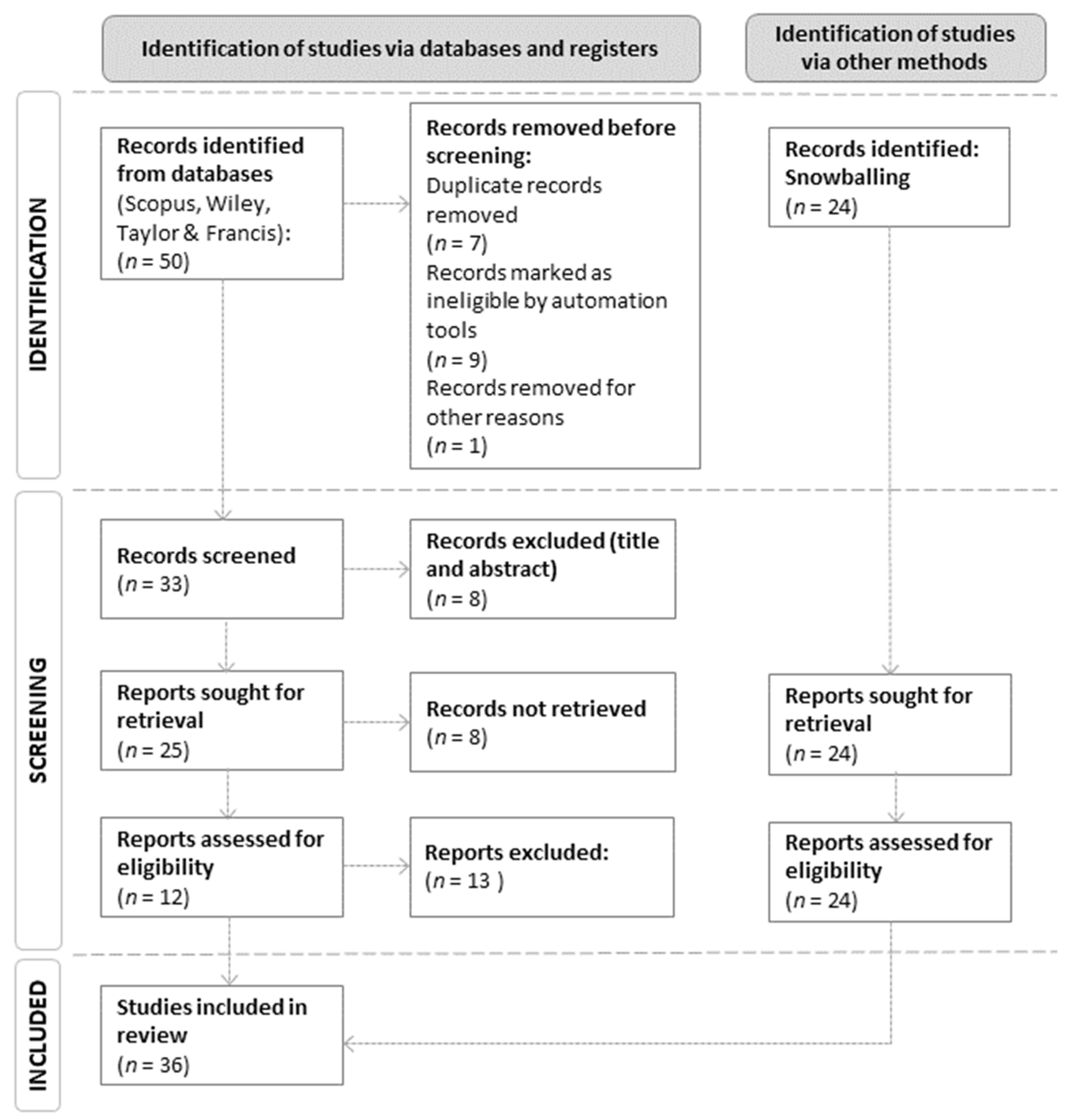
2.3. Study Selection Process

The initial database search identified 50 studies, which were further filtered to include only original research articles written in English and published between 2011 and 2021. This date range was selected because a previous general literature search on urban vacant land revealed that revitalisation efforts had gained traction during these years. After further screening, 12 studies from the database search and 24 studies obtained via other methods were selected for this review.

2.4. Data Extraction

Table 1 lists 36 studies utilising planning tools in different planning stages, including information on the author/s and study context (country).

3. Results and Discussion

3.1. Characteristics of the Studies
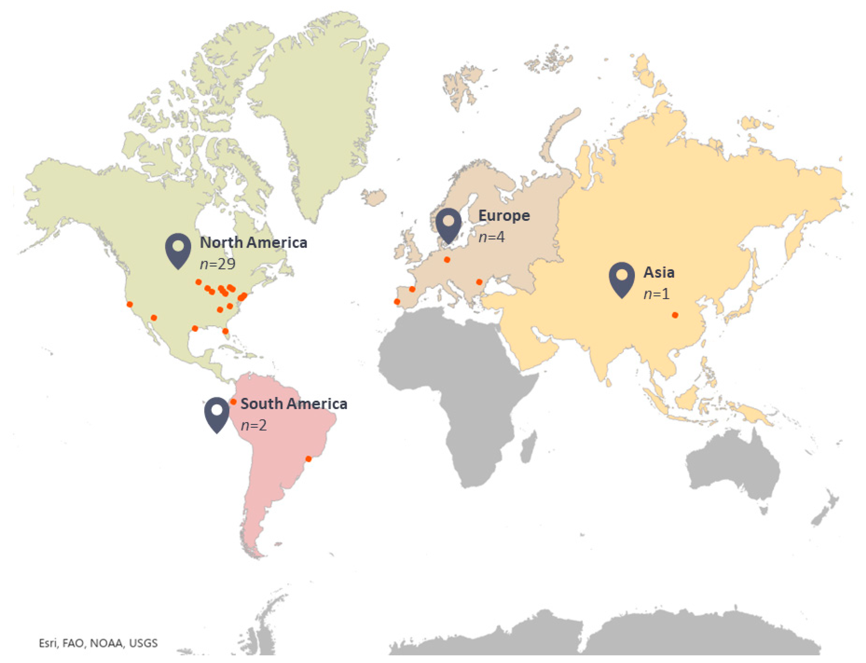
This review encompasses 36 studies discussing vacant land revitalisation planning tools. These studies covered planning tools that can be further classified as substance- and process-oriented tools (Figure 2). Substance-oriented planning tools are indicator systems, field surveys, GIS, models/simulations, and experiments. Majority of the studies utilised GIS (n = 19), followed by models/simulations (n = 13), indicator systems (n = 11), field surveys (n = 9), and experiments (n =3). Process-oriented planning tools include experts and community involvement using focus groups, the Delphi method, interviews, and questionnaire surveys. Two studies employed process-oriented tools with the community and expert involvement, and five used hybrid planning tools, combining the substance- and process-oriented tools.

3.2. Study Settings

Most of the studies were conducted in North America, with the majority originating from the United States (n = 26), and three were from Canada. The remaining studies were conducted in South America (n = 2), Europe (n = 4), and Asia (n = 1), in Shaanxi, China. Figure 3 represents the geographical distribution of the studies selected for this review.

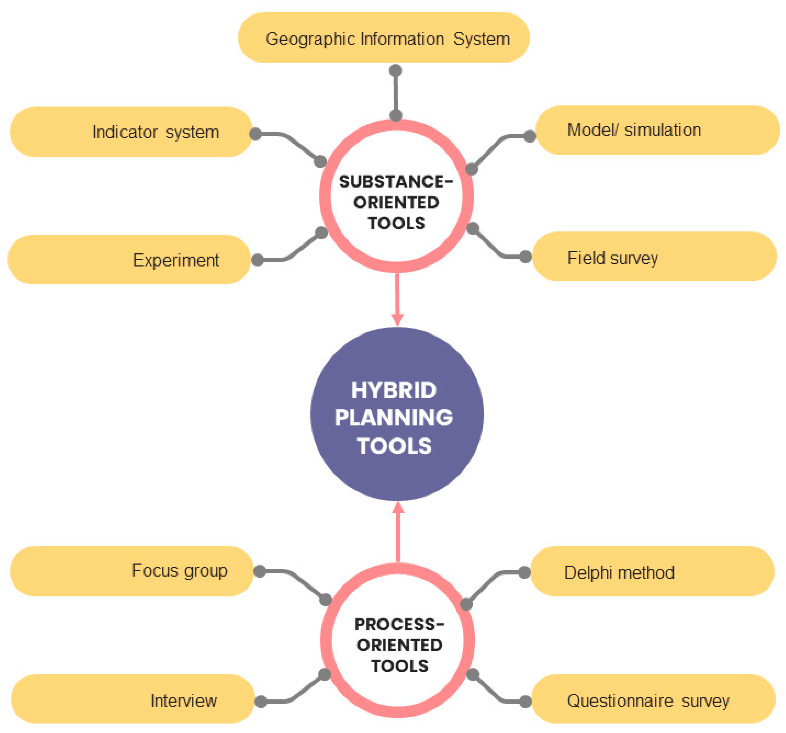
3.3. Planning Tools to Revive Urban Vacant Land

The first step in understanding the spatial distribution and site characteristics involved in urban planning is mapping and classifying land. Urban mapping creates spatial data by examining the processes that influence how a city is seen, imagined, and lived in [65]. Mapping is also necessary for researchers and professionals working in the built environment to identify urban transformation capacities. Urban practitioners utilise GIS and remote sensing data to streamline the mapping process and enable a more thorough examination of the area in question. In this regard, several studies have highlighted the use of GIS applications in mapping and assessing vacant land. Kremer et al. [33] used this approach in a land cover classification study to identify vacant parcels’ social and ecological characteristics in New York City. Similarly, McPhearson et al. [2] developed an assessment tool to capture vacant parcel heterogeneity. This tool identifies priority areas for social-ecological transformation by facilitating the quantification of ecological and social variables. Additionally, aerial photographs allow for analysing urban vacant land’s structure, function, and economic benefits, as Kim et al. [19] demonstrate. These studies show the importance of mapping as a first step towards revitalising vacant land by identifying and classifying the social and ecological characteristics of vacant parcels.
Despite the availability of remotely sensed data to aid in land mapping and preliminary assessment, conducting an inventory of the actual urban vacant land is still necessary to allow researchers to identify site qualities. To accurately capture the actual conditions of vacant parcels, field observation is typically required when assessing site characteristics. Researchers’ analysis of the results also enables them to determine how land characteristics, neighbourhood characteristics, and land cover relate to one another [33]. Additionally, it is advantageous to involve communities in this process because they may have useful local knowledge that the researchers are unaware of. Zefferman et al. [37] used a case study to identify potential vacant land for biodiversity conservation and conducted a field survey with citizen scientists to observe the existing flora and fauna. Similarly, Drake et al. [35] involved the local community in conducting vacant land inventories using smartphones; however, a lack of access to cloud-based and desktop GIS applications can be a limitation. Nevertheless, citizen involvement represents an affordable means of primary data collection. Community involvement can also spur further engagement and foster community empowerment in the form of neighbourhood improvement decision-making.
A typology of vacant land can depict patterns and ecological characteristics that help identify potential issues and select the best kind of greening strategy. Desktop studies employing GIS, satellite, or aerial imagery, as well as field surveys, can all be used to establish the land’s typology. Table 2 lists several studies that create various land vacancy types using these methods and tools. Kim et al.’s [12] comprehensive examination of urban vacant land used field observations and aerial photographs to construct a typology based on physical, biological, and social characteristics. Alternatively, Maldonado López et al. [39] developed vacant land typologies based on literature reviews, expert interviews, and an online survey. Urban vacant land’s value and potential benefits can be determined by classifying the land and identifying its economic, ecological, sociocultural, and policy components [39]. Thus, determining the types of vacant land that are suitable for restoration is crucial and can help guide regeneration planning.
Goal setting for the revitalisation effort takes centre stage in Phase 2 of the planning process. Indicator systems, GIS, models/simulations, and experiments are all examples of decision-support systems and analytical planning tools that can be used to envision potential futures for redeveloping vacant land. Through its many spatial analysis tools, GIS is a powerful resource for identifying the areas with the greatest potential for urban greening. McClintock et al. [34] utilised remotely sensed data to map areas with potential for urban agriculture. Using hotspot analysis in GIS, Smith et al. [51] mapped potential greening areas by focusing on privately owned land lacking buildings and impervious surfaces. In addition, the spatial analysis tools available in GIS can be used to assess the potential to revive vacant land. Based on the generated suitability map, vacant land reclamation strategies may be suggested, along with functions and activities that improve the city’s ecological or social health. With a focus on privately owned land that is devoid of buildings and impervious surfaces, Pearsall [36] discovered the potential of green conversions of vacant parcels to reduce urban heating inequities. This was accomplished by examining socio-spatial patterns using land surface temperature (LST) and the normalised difference vegetation index (NDVI). The Python script in GIS was developed and implemented by Newman et al. [38] to prioritise vacant lands requiring immediate intervention, particularly in cities that are shrinking and experiencing land inactivity. The tool could support a smart decline policy that prioritises citizens’ health and well-being by improving the quality and accessibility of green spaces. Furthermore, it is crucial to take into account how long urban land has been vacant, as this will likely have a more significant impact on a city than the overall number of vacant properties [38].
In addition, urban professionals can use a measurement technique called an indicator or index system, which establishes parameters for data collection. The tool is useful because it would be impractical to list all physical, environmental, social, and economic constraints and opportunities within the study areas [66]. Examples of indicator systems utilised to assess vacant land in the studies reviewed here are shown in Table 3. In a deindustrialised urban South American context, Sanches and Pellegrino [47] established criteria and indicators with which to assess the greening potential of derelict and vacant urban land by considering environmental, social, and economic factors. This analysis provided greening potential scores for vacant parcels in São Bernardo do Campo, Brazil, and indicated their use (social, environmental, or socioenvironmental) to prioritise vacant land greening. Within the context of Ploieşti, a sprawling European city, Gavrilidis et al. [53] developed criteria with which to assess vacant land’s suitability for new urban green spaces, and thus introduce an urban sprawl control framework. The process concluded with identifying the nearest available vacant land in the selected urban functional zone. Morckel [50], on the other hand, conducted a suitability analysis based on criteria that were used as variables in selecting and prioritising vacant land naturalisation in a shrinking city. As demonstrated by these studies, the establishment of indicator systems enables suitability analysis facilitated by GIS to prioritise vacant parcels’ revitalisation along ecological and social dimensions. An indicator system also envisions researchers’ and urban planners’ agenda and underlying objectives in decision-making and facilitates knowledge transfer between experts and nonexperts [67].
In some cases, citizen involvement can become a crucial aspect of reviving vacant land. Kirnbauer and Baetz [42] created a prototype of a community-based decision-support tool with which to assess the suitability of reusing vacant land. It helps citizens identify, inventory, and evaluate site suitability regarding the temporary use of vacant land. In a further extension of the same decision-support tool, the authors integrated the additional capability to produce design drawings for the vacant land reuse strategy and perform lifecycle cost analysis [43]. The tool highlights the potential to develop vacant urban land and allows for exploring trade-offs between various design alternatives. The site suitability criteria used in evaluating potential vacant sites for community gardens were developed by Eanes and Ventura [45], who incorporated input from experts and stakeholders. The site suitability evaluation process has three steps: (1) an analysis of previous inventories of vacant land, (2) an examination of community gardens already in place, and (3) obtaining input from experts and gardeners. Therefore, it is advantageous to involve the local community, as they have a deep understanding of the area, which is essential for urban practitioners and experts. Furthermore, this involvement could also promote social inclusion in place regeneration.
Planning models approximate city systems, which are represented in the form of logical and mathematical notation to enable scientific predictions [68]. These models may be quantitative or qualitative representations of phenomena, systems, or issues found in the real world [41]. Software for simulation and modelling, which integrates various environmental parameters, makes it easier to calculate projected land transformation during the decision-making process. It helps to model ecological processes on vacant land, such as the cooling effect, create networks of green spaces, and apply connectivity metrics or least-cost methods. The use of simulations in urban green space studies is similar to its use in previous studies that have investigated the effects of urban green space vegetation on cooling benefits [69], as well as the adsorption capabilities of atmospheric particulate matter [70].
Smart decline strategies primarily aim to manage declining neighbourhoods with limited resource availability. Land parcel demolition can be adopted to guide the defragmentation of urban green spaces. Frazier and Bagchi-Sen [46] mapped targeted land demolition using connectivity metrics to defragment urban green spaces. On the other hand, Johnson et al. [41] introduced a municipal shrinkage planning model to generate development strategies that jointly optimise multiple objectives associated with residential satisfaction and scale economies in terms of development and equity. One essential consideration when strategising about vacant land revitalisation is addressing the multiple objectives of urban planners. Planning models can facilitate complex decision-making involving competing objectives. Jacobs et al. [40] developed MURL-CLE (Maximizing Utility for the Reuse of Land), an open-source model in a web-based software platform, for repurposing vacant land. Additionally, a GIS-based decision-support tool provides a policy-oriented framework and methodology with which to balance competing vacant land planning objectives. Pearsall et al. [44] used a GIS-based multi-objective land allocation (MOLA) tool within a policy-oriented framework to balance competing green space, commercial, and residential planning objectives.
Planning models have also been used to simulate vacant land’s potential as urban green corridors. Two studies included in this review integrated modelling software and GIS for this purpose. Newman et al. [10] proposed structural connections between vacant lands with low development potential and high ecological prospects, which were selected by applying a raster-based suitability analysis process in GIS. These connections were mapped using the least-cost path model in the Linkage Mapper software to link habitat patches, wildlife conservation areas, wetlands, riparian corridors, and small-scale green spaces. Zhang et al. [54] introduced a two-stage connectivity modelling process, assessing landscape connectivity patterns using the FRAGSTATS software programme and identifying priority locations for green corridors on vacant lands using the least-cost path approach. Next, Kelleher et al. [55] developed an infiltration–excess model to assess the cumulative potential of vacant lands for use in stormwater management. Additionally, Koch et al. [52] integrated the application of modelling, visualisation techniques, and socioeconomic data to assess the projection of cool and compact cities. Notably, these studies were conducted in cities with prevalent land vacancies due to urban shrinkage, thus offering opportunities to defragment urban green spaces by integrating vacant land areas of ecological and hydrological significance.
Photo-elicitation simulates the evocation or anticipation of a simulated future, simplifying interactions between decision-makers and stakeholders [58]. Using this approach, Costa et al. [58] sought community input on interim planning for vacant land. In their study of an interim strategy, Todd et al. [48] introduced three stages of design guidelines for a strategy: predesign considerations, case study site selection, and guideline application. The goals of the guidelines were to communicate the design intent to the necessary stakeholders and convert contaminated vacant lands into public green space. This finding is aligned with other research that used comparable methods to analyse the public’s acceptance of wilderness in urban green spaces [71], as well as representing an instrument that can be used in a landscape-based research design phytoremediation strategy [72]. Urban practitioners can also encourage experts and the community to participate in decision-making to reach an agreement on development objectives that is consistent with the decision-makers’ initial values. Participatory workshops were introduced by Lindquist and Campbell-Arvai [59] to design and test Land.Info, a decision-support system that is used in redesigning vacant land and based on video games. This simulation tool identifies goals that are pertinent to the community and associated landscape characteristics, such as stormwater management and sociocultural advantages. This method demonstrates the benefits of the co-design process and its outcomes, with participants valuing the chance to observe how design goals shifted as they manipulated the virtual environment.
In addition to the decision-support system, experimental studies are essential in determining how vacant land can enhance ecological function. Recent studies have uncovered three experimental studies that highlight ecological restoration efforts on vacant land, with two concentrating on soil rehabilitation techniques. These include mulching methods, straw blankets, bark plots, wood shavings [55], and phyto-management using biofuel crops and bio-stabilised material [56]. Anderson and Minor [57] also investigated four methods via which to increase native plant diversity in vacant lands: seed bombing, broadcast seeding, planting plugs, and intensive gardening. These three studies provide essential evidence for practical, low-cost strategies to restore degraded urban soil and increase the prevalence of native vegetation.
The third planning stage emphasises the monitoring and ongoing evaluation of the effort to revitalise vacant land. Strategies for greening vacant land can be assessed by means of an indicator system. Simultaneously, a survey can help evaluate the success of the strategies, particularly those that involve the local community. Chicago’s Large Lot Programme is a community-based vacant land revitalisation initiative, and four case studies have shown how this programme uses a condition–care index to track and evaluate landscape change over time [60,61,62,64]. The programme enables locals to buy nearby vacant land and carry out activities such as cleaning up the blighted area and adding features that enhance its aesthetic value. Based on the same programme, Jeong et al. [63] examined the voluntary leisure activities of locals who planted trees in their vacant lots, highlighting the potential for citizen-owned vacant land to revitalise urban neighbourhoods. This evidence suggests that the programme’s ownership being transferred to residents near vacant land improved the state and maintenance of the parcels. In addition, it may be possible to anticipate the community’s land use and recreation preferences by observing their routines. A similar programme has been introduced in Detroit to mobilise residents to eradicate blight and improve the appearance of vacant lots [73]. This programme, Clean and Green, is a citywide goal to improve municipal services and residents’ quality of life by reducing maintenance costs [60]. A more equitable and fruitful co-design process between experts and citizens can be fostered through community involvement, resulting in landscape designs that are both user-centric and sustainable [59]. This opportunity allows them to explore their ideas and visions, which improves the quality of decision-making.

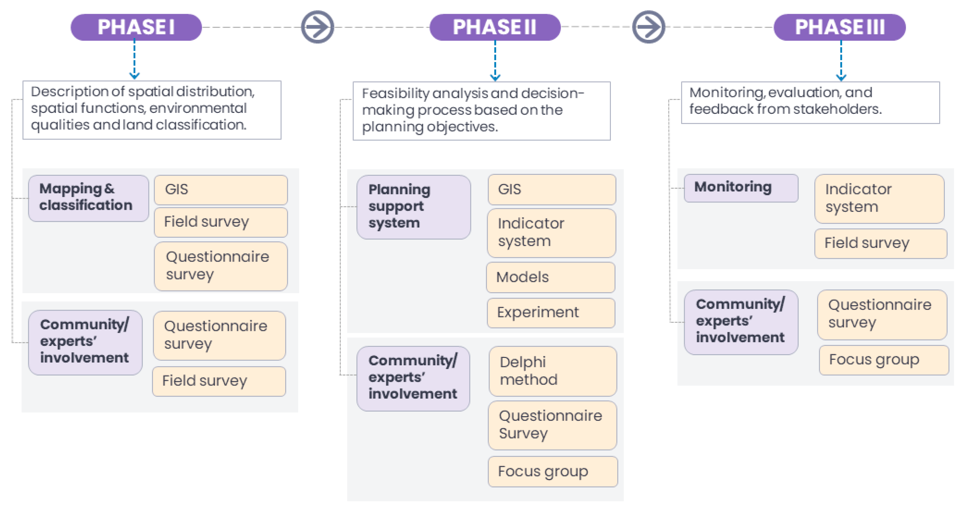
3.4. Framework to Revitalise Urban Vacant Land: A Stepwise Approach

Figure 4 depicts a framework for urban vacant land revitalisation from an ecological standpoint. It emphasises a step-by-step approach to the phases and examples of tools to help in the planning process: Phase I (mapping and classification), Phase II (decision-making), and Phase III (monitoring and maintenance). Several factors should be taken into account as the best practices for managing vacant land evolve. This requires sharing accurate geospatial data through an open-access system [74]. It is essential to maintain an accurate database of a city’s vacant land distribution to track the quantity and quality of and potential for growth in these areas. These steps involve key planners and development stakeholders in decision-making, making site suitability assessments easier [58]. Local governments that are interested in implementing or expanding their GIS and remote sensing data capacity should be prepared for a complex process, as these technologies demand substantial data-processing capabilities and trained specialists to manage the associated data.
Urban planners may benefit from simulations and models that reflect real-world phenomena, helping them make better decisions and account for all the factors that matter. Time-series aerial and street-level imagery is a more time- and cost-effective alternative to field observation for tracking the greening of vacant land. During this stage, it is also important to perform fine-scale analyses of landscape change in order to facilitate ongoing monitoring. Along with a random selection of lots, a concurrent large-scale assessment is also necessary to ensure a more effective process [60].
Notably, majority of the studies examined in this review are concentrated in the United States, primarily in declining cities, while those from Europe and South America offered viewpoints from shrinking and sprawling cities. Thus, there may be a contextual constraint due to the emphasis on shrinking and sprawling cities, in which the situation in growing cities may be disregarded. Although this analysis focuses on vacant land planning in all types of cities, perspectives on growing cities are relevant because they may reveal problems that are not present in more established, declining, or expanding cities.

3.5. Future Research

We offer three recommendations based on the findings of this systematic review. First, reviving urban vacant land necessitates adopting a holistic approach to deliver optimal outcomes. As suggested in this review, a stepwise approach that aims to provide a general idea of the planning processes, with recommendations of the tools or methods to be used for each task, may be the most appropriate. The selection of tools will also depend on the planning objectives, data availability, and data acquisition feasibility. It is imperative to consider the data-creation and monitoring process to ensure that local governments with low levels of resources will not find this process challenging to implement [51,74].
Second, the current study recommends utilising hybrid planning tools to revive vacant land, which supports an interactive process that ensures optimal output from the communicative and analytical aspects of planning [75]. Clarifying the guidelines for conducting productive, interactive sessions with stakeholders can also help translate project aims into usable workflows [76]. For example, visualisations in manual or digital illustrations can play an important role in communicating perceptions and design intentions between planning professionals and the participating communities [77]. Furthermore, clear ownership, resource allocation for maintenance, competency, and access to tools and technology are all critical components of an organisation’s readiness for such efforts [78].
Third, future research must focus on vacant land revitalisation efforts from a growing city perspective. In growing cities, especially in Asia and Africa, land utilisation decisions for urban development demand careful consideration for sustainable land use. Comparing the various approaches to valorising vacant land in this context will provide a different point of view, and thus help to guide other cities in managing vacant land resources.

4. Conclusions

The present study synthesised the existing literature on planning tools to revive urban vacant land from ecological perspectives. The review characterised these tools as substance-oriented, process-oriented, and hybrid. These tools manage the planning process, including identifying land characteristics and land assessment, simulating analysis, and monitoring the fulfilment of the overall goals. Urban practitioners can optimise the available tools and resources to plan and monitor vacant land, and thus encourage better-informed decisions and successful vacant land revitalisation. While this review focused on planning tools that emphasise the ecological improvement of vacant land, the benefits/potential outcomes along the economic and social dimensions can be observed in most of these studies’ findings. These include the potential for the green conversion of vacant lands to mitigate urban heating, which causes thermal discomfort among vulnerable populations. Furthermore, turning vacant parcels into community gardens for urban agriculture will address food-deficit issues and promote social inclusion by encouraging local community involvement. From a shrinking city’s perspective, this move will improve the quality of life of the urban inhabitants, attract new investments, and ultimately, encourage the repopulation of declining cities. On the other hand, regenerating urban voids in growing and sprawling cities through urban greening will increase the likelihood of new green space availability and accessibility to urban inhabitants. In addition, it ensures that efficient infrastructure and amenities are made accessible to the community.

Author Contributions

Conceptualisation, I.A.M.S. and S.M.; methodology, S.M.; validation, S.M., M.J.M.Y. and M.F.S.; formal analysis, I.A.M.S.; writing—original draft preparation, I.A.M.S.; writing—review and editing, I.A.M.S., S.M., M.J.M.Y. and M.F.S.; visualisation, I.A.M.S.; supervision, S.M., M.J.M.Y. and M.F.S.; project administration, I.A.M.S. and S.M.; funding acquisition, I.A.M.S. and S.M. All authors have read and agreed to the published version of the manuscript.

Funding

This research was funded by the Ministry of Higher Education Malaysia (Fundamental Research Grant Scheme (FRGS) 5540527) and Universiti Putra Malaysia (Inisiatif Putra Siswazah GP-IPS 9702400).

Institutional Review Board Statement

Not applicable.

Informed Consent Statement

Not applicable.

Data Availability Statement

Not applicable.

Conflicts of Interest

The funders had no role in the design of the study; in the collection, analyses, or interpretation of data; in the writing of the manuscript, or in the decision to publish the results.

References

  1. Németh, J.; Langhorst, J. Rethinking urban transformation: Temporary uses for vacant land. Cities 2014, 40, 143–150. [Google Scholar] [CrossRef]
  2. McPhearson, T.; Kremer, P.; Hamstead, Z.A. Mapping ecosystem services in New York City: Applying a social-ecological approach in urban vacant land. Ecosyst. Serv. 2013, 5, 11–26. [Google Scholar] [CrossRef]
  3. Anderson, E.C.; Minor, E.S. Vacant lots: An underexplored resource for ecological and social benefits in cities. Urban For. Urban Green. 2017, 21, 146–152. [Google Scholar] [CrossRef]
  4. Kim, G. The Public Value of Urban Vacant Land: Social Responses and Ecological Value. Sustainability 2016, 8, 486. [Google Scholar] [CrossRef]
  5. Hou, D.; Song, Y.; Zhang, J.; Hou, M.; Connor, D.O.; Harclerode, M. Climate change mitigation potential of contaminated land redevelopment: A city-level assessment method. J. Clean. Prod. 2018, 171, 1396–1406. [Google Scholar] [CrossRef]
  6. Prener, C.G.; Braswell, T.H.; Monti, D.J. St. Louis’s “urban prairie”: Vacant land and the potential for revitalization. J. Urban Aff. 2020, 42, 371–389. [Google Scholar] [CrossRef]
  7. Schilling, J.; Logan, J. Greening the rust belt: A green infrastructure model for right sizing America’s shrinking cities. J. Am. Plan. Assoc. 2008, 74, 451–466. [Google Scholar] [CrossRef]
  8. Pallagst, K.; Vargas-Hernández, J.; Hammer, P. Green Innovation Areas—En Route to Sustainability for Shrinking Cities? Sustainability 2019, 11, 6674. [Google Scholar] [CrossRef]
  9. Laprise, M.; Lufkin, S.; Rey, E. An operational monitoring tool facilitating the transformation of urban brownfields into sustainable neighborhoods. Build. Environ. 2018, 142, 221–233. [Google Scholar] [CrossRef]
  10. Newman, G.D.; Smith, A.L.; Brody, S.D. Repurposing vacant land through landscape connectivity. Landsc. J. 2017, 36, 37–57. [Google Scholar] [CrossRef]
  11. Beames, A.; Broekx, S.; Schneidewind, U.; Landuyt, D.; Meulen, M.V.D.; Heijungs, R.; Seuntjens, P. Amenity proximity analysis for sustainable brownfield redevelopment planning. Landsc. Urban Plan. 2018, 171, 68–79. [Google Scholar] [CrossRef]
  12. Kim, G.; Miller, P.A.; Nowak, D.J. Urban vacant land typology: A tool for managing urban vacant land. Sustain. Cities Soc. 2018, 36, 144–156. [Google Scholar] [CrossRef]
  13. Kim, G.; Newman, G.; Jiang, B. Urban regeneration: Community engagement process for vacant land in declining cities. Cities 2020, 102, 102730. [Google Scholar] [CrossRef] [PubMed]
  14. Wesener, A. Temporary urbanism and urban sustainability after a natural disaster: Transitional community-initiated open spaces in Christchurch, New Zealand. J. Urban. 2015, 8, 406–422. [Google Scholar] [CrossRef]
  15. Patti, D.; Polyak, L. From practice to policy: Frameworks for temporary use. Urban Res. Pract. 2015, 8, 122–134. [Google Scholar] [CrossRef]
  16. Rall, E.L.; Haase, D. Creative intervention in a dynamic city: A sustainability assessment of an interim use strategy for brownfields in Leipzig, Germany. Landsc. Urban Plan. 2011, 100, 189–201. [Google Scholar] [CrossRef]
  17. Runhaar, H.; Driessen, P.P.J.; Soer, L. Sustainable urban development and the challenge of policy integration: An assessment of planning tools for integrating spatial and environmental planning in the Netherlands. Environ. Plan. B Plan. Des. 2009, 36, 417–431. [Google Scholar] [CrossRef]
  18. Gardiner, M.M.; Burkman, C.E.; Prajzner, S.P. The value of urban vacant land to support arthropod biodiversity and ecosystem services. Environ. Entomol. 2013, 42, 1123–1136. [Google Scholar] [CrossRef]
  19. Kim, G.; Miller, P.A.; Nowak, D.J. Assessing urban vacant land ecosystem services: Urban vacant land as green infrastructure in the City of Roanoke, Virginia. Urban For. Urban Green. 2015, 14, 519–526. [Google Scholar] [CrossRef]
  20. Kowarik, I. Urban wilderness: Supply, demand, and access. Urban For. Urban Green. 2018, 29, 336–347. [Google Scholar] [CrossRef]
  21. Anderson, E.C.; Minor, E.S. Assessing social and biophysical drivers of spontaneous plant diversity and structure in urban vacant lots. Sci. Total Environ. 2019, 653, 1272–1281. [Google Scholar] [CrossRef] [PubMed]
  22. Villaseñor, N.R.; Chiang, L.A.; Hernández, H.J.; Escobar, M.A.H. Vacant lands as refuges for native birds: An opportunity for biodiversity conservation in cities. Urban For. Urban Green. 2020, 49, 126632. [Google Scholar] [CrossRef]
  23. Kopecká, M.; Szatmári, D.; Rosina, K. Analysis of Urban Green Spaces Based on Sentinel-2A: Case Studies from Slovakia. Land 2017, 6, 25. [Google Scholar] [CrossRef]
  24. Huang, C.; Yang, J.; Jiang, P. Assessing Impacts of Urban Form on Landscape Structure of Urban Green Spaces in China Using Landsat Images Based on Google Earth Engine. Remote Sens. 2018, 10, 1569. [Google Scholar] [CrossRef]
  25. Haase, D.; Jänicke, C.; Wellmann, T. Front and back yard green analysis with subpixel vegetation fractions from earth observation data in a city. Landsc. Urban Plan. 2019, 182, 44–54. [Google Scholar] [CrossRef]
  26. Kanniah, K.D. Quantifying green cover change for sustainable urban planning: A case of Kuala Lumpur, Malaysia. Urban For. Urban Green. 2017, 27, 287–304. [Google Scholar] [CrossRef]
  27. Deng, J.; Huang, Y.; Chen, B.; Tong, C.; Liu, P.; Wang, H.; Hong, Y. A methodology to monitor urban expansion and green space change using a time series of multi-sensor SPOT and Sentinel-2A images. Remote Sens. 2019, 11, 1230. [Google Scholar] [CrossRef]
  28. Yang, G.; Zhao, Y.; Xing, H.; Fu, Y.; Liu, G.; Kang, X.; Mai, X. Understanding the changes in spatial fairness of urban greenery using time-series remote sensing images: A case study of Guangdong-Hong Kong-Macao Greater Bay. Sci. Total Environ. 2020, 715, 136763. [Google Scholar] [CrossRef]
  29. Dinda, S.; Das Chatterjee, N.; Ghosh, S. An integrated simulation approach to the assessment of urban growth pattern and loss in urban green space in Kolkata, India: A GIS-based analysis. Ecol. Indic. 2021, 121, 107178. [Google Scholar] [CrossRef]
  30. Ucar, Z.; Bettinger, P.; Merry, K.; Akbulut, R.; Siry, J. Estimation of urban woody vegetation cover using multispectral imagery and LiDAR. Urban For. Urban Green. 2018, 29, 248–260. [Google Scholar] [CrossRef]
  31. Yan, J.; Zhou, W.; Han, L.; Qian, Y. Mapping vegetation functional types in urban areas with WorldView-2 imagery: Integrating object-based classification with phenology. Urban For. Urban Green. 2018, 31, 230–240. [Google Scholar] [CrossRef]
  32. Mengist, W.; Soromessa, T.; Legese, G. Method for conducting systematic literature review and meta-analysis for environmental science research. MethodsX 2020, 7, 100777. [Google Scholar] [CrossRef] [PubMed]
  33. Kremer, P.; Hamstead, Z.A.; McPhearson, T. A social-ecological assessment of vacant lots in New York City. Landsc. Urban Plan. 2013, 120, 218–233. [Google Scholar] [CrossRef]
  34. McClintock, N.; Cooper, J.; Khandeshi, S. Assessing the potential contribution of vacant land to urban vegetable production and consumption in Oakland, California. Landsc. Urban Plan. 2013, 111, 46–58. [Google Scholar] [CrossRef]
  35. Drake, L.; Ravit, B.; Lawson, L. Developing a Vacant Property Inventory through Productive Partnerships: A University, NGO, and Municipal Planning Collaboration in Trenton, New Jersey. Cities Environ. 2016, 8, 6. [Google Scholar]
  36. Pearsall, H. Staying cool in the compact city: Vacant land and urban heating in Philadelphia, Pennsylvania. Appl. Geogr. 2017, 79, 84–92. [Google Scholar] [CrossRef]
  37. Zefferman, E.P.; McKinney, M.L.; Cianciolo, T.; Fritz, B.I. Knoxville’s urban wilderness: Moving toward sustainable multifunctional management. Urban For. Urban Green. 2018, 29, 357–366. [Google Scholar] [CrossRef]
  38. Newman, G.; Kim, Y.; Kim, G.; Lee, R.J.; Gu, D.; Forghanparast, K.; Goldberg, D. A python script for longitudinally measuring the duration of vacant land uses. J. Spat. Sci. 2022, 67, 129–141. [Google Scholar] [CrossRef]
  39. Maldonado López, J.I.; Kim, G.; Lei, Y.; Newman, G.; Suppakittpaisarn, P. An assessment method and typology for the regeneration of vacant land in Quito, Ecuador. Urban For. Urban Green. 2021, 62, 127130. [Google Scholar] [CrossRef]
  40. Jacobs, S.; Dyson, B.; Shuster, W.D.; Stockton, T. A Structured Decision Approach for Integrating and Analyzing Community Perspectives in Re-Use Planning of Vacant Properties in Cleveland, Ohio. Urban Land Use 2013, 6, 163–188. [Google Scholar] [CrossRef]
  41. Johnson, M.P.; Hollander, J.; Hallulli, A. Maintain, demolish, re-purpose: Policy design for vacant land management using decision models. Cities 2014, 40, 151–162. [Google Scholar] [CrossRef]
  42. Kirnbauer, M.; Baetz, B.W. A prototype community-based planning tool for evaluating site suitability for the temporary reuse of vacant lands. Int. J. Urban Sustain. Dev. 2014, 6, 221–240. [Google Scholar] [CrossRef]
  43. Kirnbauer, M.; Baetz, B. Prototype Decision-Support System for Designing and Costing Municipal Green Infrastructure. J. Urban Plan. Dev. 2014, 140, 04014004. [Google Scholar] [CrossRef]
  44. Pearsall, H.; Lucas, S.; Lenhardt, J. The contested nature of vacant land in Philadelphia and approaches for resolving competing objectives for redevelopment. Cities 2014, 40, 163–174. [Google Scholar] [CrossRef]
  45. Eanes, F.; Ventura, S. Inventorying Land Availability and Suitability for Community Gardens in Madison, Wisconsin. Cities Environ. 2015, 8, 2. [Google Scholar]
  46. Frazier, A.E.; Bagchi-Sen, S. Developing open space networks in shrinking cities. Appl. Geogr. 2015, 59, 1–9. [Google Scholar] [CrossRef]
  47. Sanches, P.M.; Pellegrino, P.R.M. Greening potential of derelict and vacant lands in urban areas. Urban For. Urban Green. 2016, 19, 128–139. [Google Scholar] [CrossRef]
  48. Todd, L.F.; Landman, K.; Kelly, S. Phytoremediation: An interim landscape architecture strategy to improve accessibility of contaminated vacant lands in Canadian municipalities. Urban For. Urban Green. 2016, 18, 242–256. [Google Scholar] [CrossRef]
  49. Wang, J.; Liu, H.; Wu, X.; Li, C.; Wang, X. Effects of different types of mulches and legumes for the restoration of urban abandoned land in semi-arid northern China. Ecol. Eng. 2017, 102, 55–63. [Google Scholar] [CrossRef]
  50. Morckel, V. Using suitability analysis to select and prioritize naturalization efforts in legacy cities: An example from Flint, Michigan. Urban For. Urban Green. 2017, 27, 343–351. [Google Scholar] [CrossRef]
  51. Smith, J.P.; Li, X.; Turner, B.L. Lots for greening: Identification of metropolitan vacant land and its potential use for cooling and agriculture in Phoenix, AZ, USA. Appl. Geogr. 2017, 85, 139–151. [Google Scholar] [CrossRef]
  52. Koch, F.; Bilke, L.; Helbig, C.; Schlink, U. Compact or cool ? The impact of brown fi eld redevelopment on inner-city micro climate. Sustain. Cities Soc. 2018, 38, 31–41. [Google Scholar] [CrossRef]
  53. Gavrilidis, A.A.; Niță, M.R.; Onose, D.A.; Badiu, D.L.; Năstase, I.I. Methodological framework for urban sprawl control through sustainable planning of urban green infrastructure. Ecol. Indic. 2019, 96, 67–78. [Google Scholar] [CrossRef]
  54. Zhang, Z.; Meerow, S.; Newell, J.P.; Lindquist, M. Enhancing landscape connectivity through multifunctional green infrastructure corridor modeling and design. Urban For. Urban Green. 2019, 38, 305–317. [Google Scholar] [CrossRef]
  55. Kelleher, C.; Golden, H.E.; Burkholder, S.; Shuster, W. Urban vacant lands impart hydrological benefits across city landscapes. Nat. Commun. 2020, 11, 1563. [Google Scholar] [CrossRef]
  56. Míguez, F.; Gómez-Sagasti, M.T.; Hernández, A.; Artetxe, U.; Blanco, F.; Castañeda, J.H.; Lozano, J.V.; Garbisu, C.; Becerril, J.M. In situ phytomanagement with Brassica napus and bio-stabilised municipal solid wastes is a suitable strategy for redevelopment of vacant urban land. Urban For. Urban Green. 2020, 47, 126550. [Google Scholar] [CrossRef]
  57. Anderson, E.C.; Minor, E.S. Assessing four methods for establishing native plants on urban vacant land. Ambio 2021, 50, 695–705. [Google Scholar] [CrossRef]
  58. Costa, P.; Brito-Henriques, E.; Cavaco, C. Interim reuse in urban derelicts: Uncovering the community’s attitudes and preferences through scenario-elicitation. Cities 2021, 111, 103103. [Google Scholar] [CrossRef]
  59. Lindquist, M.; Campbell-Arvai, V. Co-designing vacant lots using interactive 3D visualizations—Development and application of the Land.Info DSS. Landsc. Urban Plan. 2021, 210, 104082. [Google Scholar] [CrossRef]
  60. Gobster, P.H.; Hadavi, S.; Rigolon, A.; Stewart, W.P. Measuring landscape change, lot by lot: Greening activity in response to a vacant land reuse program. Landsc. Urban Plan. 2020, 196, 103729. [Google Scholar] [CrossRef]
  61. Gobster, P.H.; Rigolon, A.; Hadavi, S.; Stewart, W.P. Beyond proximity: Extending the “greening hypothesis” in the context of vacant lot stewardship. Landsc. Urban Plan. 2020, 197, 103773. [Google Scholar] [CrossRef]
  62. Gobster, P.H.; Rigolon, A.; Hadavi, S.; Stewart, W.P. The condition-care scale: A practical approach to monitoring progress in vacant lot stewardship programs. Landsc. Urban Plan. 2020, 203, 103885. [Google Scholar] [CrossRef]
  63. Jeong, W.; Stewart, W.P.; Gobster, P.H.; van Riper, C.J. Green Leisure: Resistance and Revitalization of Urban Neighborhoods. Leis. Sci. 2021, 1–21. [Google Scholar] [CrossRef]
  64. Rigolon, A.; Banerjee, D.; Gobster, P.; Hadavi, S.; Stewart, W. Transferring Vacant Lots to Private Ownership Improves Care and Empowers Residents: Evidence From Chicago. J. Am. Plan. Assoc. 2021, 87, 570–584. [Google Scholar] [CrossRef]
  65. Dovey, K.; Ristic, M.; Pafka, E. Mapping as Spatial Knowledge. In Mapping Urbanities: Morphologies, Flows, Possibilities; Dovey, K., Pafka, E., Ristic, M., Eds.; Routledge: New York, NY, USA, 2018; pp. 1–16. [Google Scholar]
  66. Turnhout, E. The effectiveness of boundary objects: The case of ecological indicators. Sci. Public Policy 2009, 36, 403–412. [Google Scholar] [CrossRef]
  67. Mair, S.; Jones, A.; Ward, J.; Christie, I.; Druckman, A.; Lyon, F. A Critical Review of the Role of Indicators in Implementing the Sustainable Development Goals. In Handbook of Sustainability Science and Research; World Sustainability Series; Springer: Cham, Switzerland, 2018; pp. 41–56. [Google Scholar] [CrossRef]
  68. Batty, M. Classifying urban models. Environ. Plan. B Plan. Des. 2016, 43, 251–256. [Google Scholar] [CrossRef]
  69. Yang, J.; Hu, X.; Feng, H.; Marvin, S. Verifying an ENVI-met simulation of the thermal environment of Yanzhong Square Park in Shanghai. Urban For. Urban Green. 2021, 66, 127384. [Google Scholar] [CrossRef]
  70. Deng, S.; Ma, J.; Zhang, L.; Jia, Z.; Ma, L. Microclimate simulation and model optimization of the effect of roadway green space on atmospheric particulate matter. Environ. Pollut. 2019, 246, 932–944. [Google Scholar] [CrossRef]
  71. Hwang, Y.H.; Yue, Z.E.J.; Ling, S.K.; Tan, H.H.V. It’s ok to be wilder: Preference for natural growth in urban green spaces in a tropical city. Urban For. Urban Green. 2019, 38, 165–176. [Google Scholar] [CrossRef]
  72. Wilschut, M.; Theuws, P.A.; Duchhart, I. Phytoremediative urban design: Transforming a derelict and polluted harbour area into a green and productive neighbourhood. Environ. Pollut. 2013, 183, 81–88. [Google Scholar] [CrossRef]
  73. Kim, G. An integrated system of urban green infrastructure on different types of vacant land to provide multiple benefits for local communities. Sustain. Cities Soc. 2018, 36, 116–130. [Google Scholar] [CrossRef]
  74. Xu, S.; Manzke, N.; De Lange, N.; Zülsdorf, J.; Kada, M.; Ehlers, M. Identification of potential urban development areas and extraction of urban land use information based on open source data. In Proceedings of the 10th International Conference on Environmental Engineering, ICEE 2017, Vilnius, Lithuania, 27–28 April 2017. [Google Scholar] [CrossRef]
  75. Pelzer, P.; Geertman, S.; van der Heijden, R. Knowledge in communicative planning practice: A different perspective for planning support systems. Environ. Plan. B Plan. Des. 2015, 42, 638–651. [Google Scholar] [CrossRef]
  76. van Dijk, T.; Ubels, H. How Dutch professionals conduct interactive design sessions to foster ‘shared understanding. Environ. Plan. B Plan. Des. 2016, 43, 464–479. [Google Scholar] [CrossRef]
  77. Gnatzy, T.; Warth, J.; von der Gracht, H.; Darkow, I.L. Validating an innovative real-time Delphi approach—A methodological comparison between real-time and conventional Delphi studies. Technol. Forecast. Soc. Change 2011, 78, 1681–1694. [Google Scholar] [CrossRef]
  78. Ganis, M.; Minnery, J.; Mateo-Babiano, I. Planning people–places: A small world network paradigm for masterplanning with people in mind. Environ. Plan. B Plan. Des. 2016, 43, 1075–1095. [Google Scholar] [CrossRef]
Figure 1. Flow chart of the systematic review process based on PRISMA guidelines.
Urbansci 07 00058 g001
Figure 2. Planning tools to manage urban vacant land revitalisation planning.
Urbansci 07 00058 g002
Figure 3. Geographical distribution of the selected studies on planning tools to revive urban vacant land.
Urbansci 07 00058 g003
Figure 4. Framework for urban vacant land revitalisation: a stepwise approach.
Urbansci 07 00058 g004
Table 1. Selected studies on planning tools for vacant land revitalisation.
Planning Tools to Revitalise Urban Vacant Land
Author/s CountrySubstance-Oriented ToolsProcess-Oriented Tools
GISModel/SimulationIndicator SystemField SurveyExperimentFocus GroupInterviewDelphi MethodQuestionnaire Survey
Phase I
Mapping and classification
[33]USA
[34]USA
[2]USA
[19]USA
[35]USA
[36]USA
[12]USA
[37]USA
[38]USA
[39]Ecuador
Phase II
Decision-making
[40]USA
[41]USA
[42]Canada
[43]Canada
[44]USA
[45] *USA
[46]USA
[47]Brazil
[48] *Canada
[49]China
[50]USA
[10]USA
[51]USA
[52]Germany
[53] *Romania
[54]USA
[55]USA
[56]Spain
[57]USA
[58] *Portugal
[59]USA
Phase III
Monitoring
[60]USA
[61]USA
[62]USA
[63]USA
[64] *USA
Total191311933114
* Hybrid planning tools.
Table 2. Vacant land typologies with the intended purposes.
AuthorPurposeTypology
[33]Actual uses of vacant lotsUnused land, private house, commercial/industrial, community garden, park, tree cover in residential streets, sport fields, road, roadside pavement or sidewalk, junk yard, parking lot, non-commercial parking, other.
[2]Land cover typeFine vegetation, coarse vegetation, paved surface, building cover, water.
[35]Land cover typeParcels with structure—vacant building, vacant land, occupied building.
Parcels without structure—parking lot, open space (park, garden, or cemetery), utility or rail, lot.
[12]Land cover typePost-industrial sites, unattended sites with vegetation, derelict sites, natural sites, transportation-related sites.
[39]Potential use in economic, ecological, sociocultural, and policy respectsAbandoned land, undeveloped land, post-industrial land, land held for speculation, derelict land.
Table 3. Indicator systems to assess vacant land revitalisation.
AuthorObjectiveCriteria/Indicators
[47]Identifying the greening potential of derelict and vacant lands in urban areas.Ecology—habitat diversity, impact on the surroundings, connectivity with other green spaces, priority for ecological restoration, viability for ecological restoration.
Stormwater—stormwater retention and treatment (volume and quality).
Community—mobility, pedestrian pathway and cycle routes, accessibility, deficit in terms of green spaces, potential for use by the community, social inclusion, and cohesion.
[45]Community garden site suitability index.Adjacent water sources, solar access, size, vehicular access, surface and vegetation, land-use conflicts.
[50]Using suitability analysis to select and prioritise naturalisation efforts in legacy cities.Contiguous vacant land, prospective vacant land, ownership, green land use, parks, green buffer, industrial land use, water features, property values, population change.
[53]The framework assesses which model of UGS is best for planning based
on available vacant lands in a city’s urban functional zone.
Management cost, ease of construction, acceptance, efficiency in combating climate change, air quality improvement efficiency, income generation, biodiversity benefits and conservation, social network simulation, specificity (dependent on natural characteristics).
[10]Socioenvironmental factors via which to determine development potential and ecological values of vacant land. Population, soil, property value, land cover, land use, Federal Emergency Management Agency (FEMA) flood plains, hurricane risk zones, conservation area, proximity to amenities.
[42]Site suitability index for determining the temporary reuse of vacant land. Neighbourhood quality, development potential, visual quality, compatibility, transportation, vulnerable populations.
[60,61,62,63]Assess vacant land management in response to a vacant parcel reuse program (condition–care scale).Mismanaged, unmanaged, periodically managed, regularly managed, small-scale gardens and other cues to care, moderate-scale gardens and other cues to care, extensive gardens and other cues to care.
Disclaimer/Publisher’s Note: The statements, opinions and data contained in all publications are solely those of the individual author(s) and contributor(s) and not of MDPI and/or the editor(s). MDPI and/or the editor(s) disclaim responsibility for any injury to people or property resulting from any ideas, methods, instructions or products referred to in the content.

