


A Typology for Urban Landscape Progression: Toward a Sustainable Planning Mechanism in Kano Metropolis, Nigeria

 ,
, 
Abstract
:1. Introduction
1.1. Landscape-Based Approach
1.2. Sustainability and Urban Landscape
1.3. Aim and Objections
- i.
- To authenticate the historical establishment of some selected wards/districts within the Kano metropolis.
- ii.
- To verify the landscape assets and land-use typology of some sampled wards/districts within the Kano metropolis.
2. Materials and Methods
3. Results
3.1. Theoretical Findings
3.1.1. Kano Urban Patterns in Pre-Colonial, Colonial and Post-Colonial Period
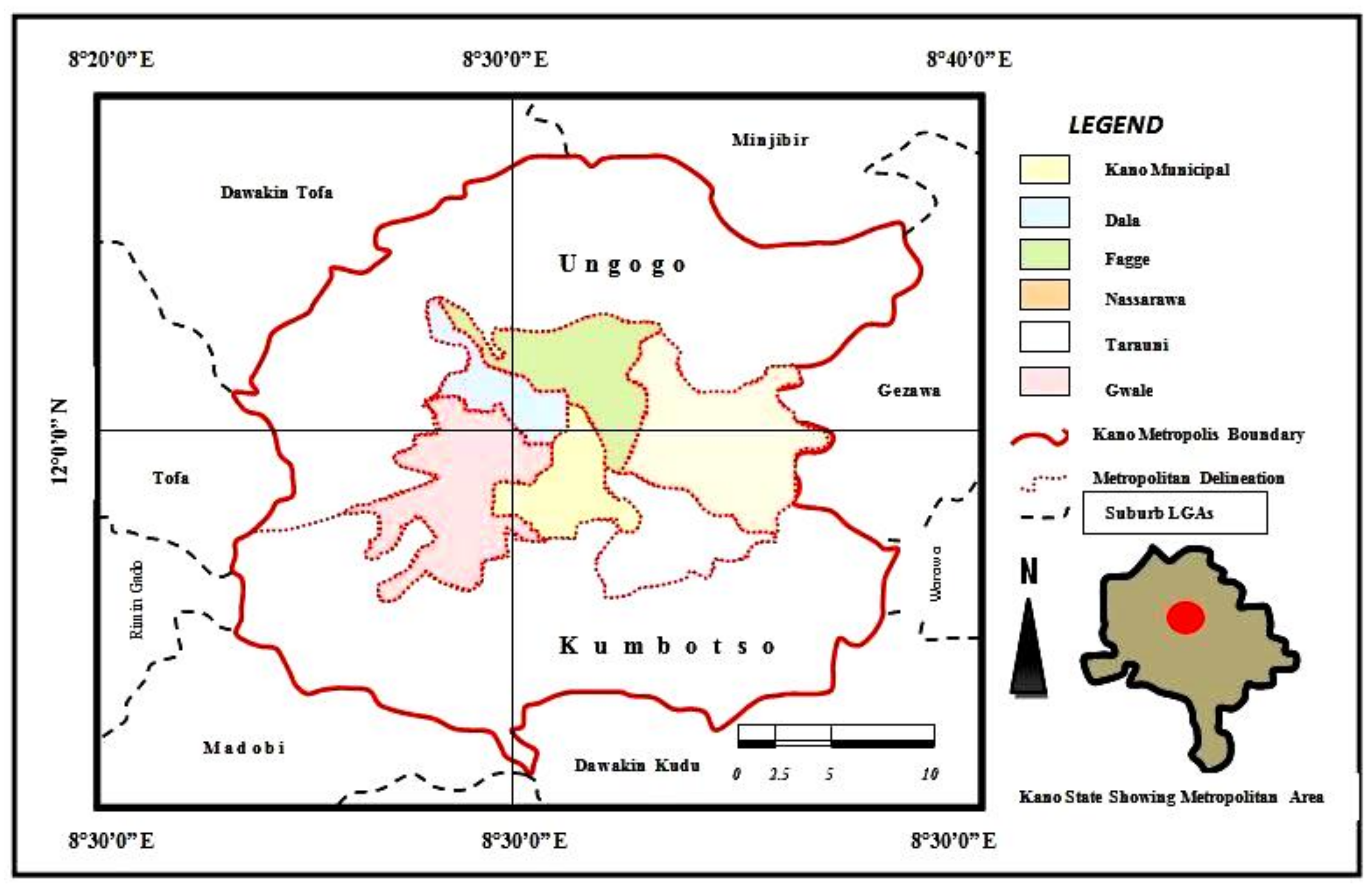
3.1.2. The Evolution of Some Wards within Metropolitan Kano
- (a)
- Ward delineation procedures
- (b)
- Description of the selected wards
- i.
- Babbangiji ward is located in the Tarauni local government area, accessed via the “Massalacin Murtala” road southwest of Kano Metropolis. The Hausa/Fulani clans dominate the commune and other tribes from the northern part of Nigeria. They are mostly artisans, builders, carpenters, and small-scale traders as well low-income workers. There is no marketplace, but it has clinics, government primary schools, and secondary schools for boys and girls.
- ii.
- Bachirawa is situated in the Ungogo local government area, accessed via the Katsina road in the northern part of metropolitan Kano. Established in the 1980s and dominated by the Hausa/Fulani tribes, most people come from Katsina state and other tribes from the northern part of Nigeria. It consists of 75% contemporary Hausa residential structures and 25% modern buildings.
- iii.
- Challawa, located in Panshekara, in the Kumbotso local government area in the western part of the metropolitan areas. It was originally a Fulani settlement due to its closeness to river Challawa, and it had a rich soil suitable for farming and the rearing of animals. The town started developing in the early 1970s due to the institution of the Kano Water Works (WRECCA) and manufacturing industries. Various tribes from all parts of the country live there.
- iv.
- Dakata/Kawaji/Badawa is located in the Nassarawa local government area and accessed via the Yankaba/Hadejia road, in the northeastern part of Kano Metropolis. Dakata/Kawaji was established around the early 1950s and a few houses are built in mud and there are also modern building materials such as cement blocks, metal doors, and windows. On the other hand, Badawa was established in the late 1970s. It is an exemplary ghetto commune with 97% contemporary typologies.
- v.
- Dala is positioned in the Dala local government area and is a name given to one of the ancestors of the “Abagayawa”, known as the original indigenes of Kano. It has been associated with iron smelting and smithing, and the “Tsumburbura Shrine” [43,45]. Dala ward is a settlement at the bottom of a hill, with a gentle slope of about 2–3 mm in the east and south direction, and about 2 min the northern direction toward the Gwammaja Road, while due west, there is a deep and dirty water body of about 6–10 m depth.
- vi.
- Dorayi/Kabuga is located in the Gwale local government area and is accessed via the BUK road, almost at the center of the Kano metropolitan area. The majority of the residents of Rijiyar-Zaki, Dorayi, Kabuga housing estate, and Yamadawa residential areas are, by origin, indigenes of the old city of Kano, who for reasons of choice, city slum, improvement in economic status, and proximity to the place of work, among others, decided to relocate. While Dorayi is a progressive slum commune with 86% contemporary typologies, Kabuga remains a planned layout.
- vii.
- Fagge/Jabba is located in Fagge local government area. Fagge is almost in the center of Kano Metropolis and accessible from the Ibrahim Taiwo road. It is one of the initial areas laid out by the colonial masters in the later 1950s and is a predominantly non-indigenous settlement (absorbing Katsina and Niger immigrants). However, Jabba is accessed through the airport road due northeast of Kano Metropolis. It was founded around 1960 and was originally a resettlement scheme for residents or villagers in the area of the present Aminu Kano International Airport, but is now dominated by the Igbo business class and other ethnic groups from southern part of the country.
- viii.
- Hotoro is located partly in Tarauni and partly in Nassarawa local government area. It is accessible via the Maiduguri road and the eastern ring road by-pass due southeast of metropolitan Kano. Created around 1950 and initially under Ungogo District, it consists of three parts: Hotoro Kudu (South), Hotoro Arewa (North), and Hotoro Danmarke. It was later segregated into sub-units or wards headed by “Dagaci” and “Mai Unguwani”, with the respective ward heads now separated by the Maiduguri highway due south east of Kano Metropolis. Ref. [45] proclaims that the name Hotoro derived from Fulani, from the word “Hutu”, meaning rest. The area used to be the resting place for caravans and hunters (Fatake and Mafarauta) and used as a transit camp (Zango) under one famous well-known “Rijiyar Hagama”.
- ix.
- Kofar Mazugal is located in the Dala local government area, accessed via the Gwamaja/Mayanka road due south of Kano Metropolis. It originated in the 19th century when the area was predominantly dominated by blacksmiths who operated their trade there. The name was taken from a fire-blowing instrument used by the smiths. Blowing of fire continually emits the sound “Zugal-Zugal” which is why the area is called Mazugal [45]. As such, when the ancient wall surrounded Kano, a gate was opened at Mazugal, named “Kofar Mazugal”.
- x.
- Kumbotso remains in the Kumbotso local government area, and joined examples of traditional Hausa and Fulani communes. A modern settlement was purposely established for irrigation farmers from the Kumbotso River from 1977–1982, during Rimi’s administration. The topography remains similar to that of Panshekara, but in recent time it hosts educational institutes, industries, residential quarters, trade zones and farmland.
- xi.
- Sharada is situated in the Municipal local government area, accessible via the B.U.K road due south of Kano metropolitan area. It was established around the 1950s by Malam Aminu Kano, a leading politician in Kano politics. It has two sections and Sharada “Fegin Mayu” is occupied by more craftsmen and low-income earners than the industrial zone which was formally farmland.
- xii.
- Ungogo remains in the Ungogo local government are, accessible through the Katsina road northeast of the Kano Metropolitan area. It was established over 200 years ago as a Fulani cattle farm settlement, and around 1970, the then government sub-divided the farmland into housing layouts. Although in recent times, there is a lot of infill in the typology.
- xiii.
- Unguwa Uku is positioned in Tarauni local government area, accessible via the Zaria Road due southwest of Kano Metropolis. Historically, the name originated from three Fulani compound heads, namely Alu, Mohd, and Nono, surrounded by their farmland, for farming and rearing their animals. Each of them settled in different areas that produced the term “Rikuni Uku” (three provinces or villages), later called “Unguwa Uku” around 1970 [48]. It has one “Dagaci” (district head) and three ward heads (Masu Unguwani) and is dominated by low-income earners such as traders, craftsmen and workers.
- xiv.
- Yakasai remains among the three heads of pre-Islamic Hausa, alongside ‘Gwale’ and ‘Sheshe’, who came from the historic empire of Gaya, east of Kano [20]. The current ward has been relocated from an older ward since the region became a part of the city only after the 15th century extension of the city wall. At one time, Yakasai was the largest ward in the city, in terms of land and inhabitants; later, it was sub-divided into A and B wards [45]. In 1961, an added ward emerged, called Yakasai “Sabuwar Unguwa”, founded to provide relief in governance. During colonial times, its location, its relationship with the Mallam class, and its ability to take in immigrants made it a quarter preferred by the mid-level Native Authority civil servants.
3.2. Spatial Data
Landscape Forms and Typologies
- i.
- In the Dala local government area of Kano Metropolis, Dala ward has an organic and partly gridded arrangement with quite traditional Hausa–Fulani dwellings. However, Kofar-Mazugal ward has a squatter slum with partly traditional Hausa–Fulani dwellings.
- ii.
- The Fagge local government area, Kano Metropolis, comprises Fagge ward with a partly gridded layout and contemporary dwellings, and Jabba ward with a grid and partly irregular layout, as well as contemporary with a few traditional dwellings.
- iii.
- The sampled wards in the Gwale local government area are Gwale, which has an organic and partly gridded layout with traditional Hausa–Fulani dwellings, although transformed over time, while Dorayi/Kabuga has agridded and partly irregular layout with contemporary dwellings.
- iv.
- In Kano Municipal local government area, Kano Metropolis, Sharada ward has a gridded and partly organic layout with contemporary dwellings, whereas Yakasai ward has an organic and partly gridded layout with traditional Hausa–Fulani dwellings.
- v.
- The sampled wards in the Kumbotso local government area are Challawa, with a squatter slum and traditional Hausa–Fulani dwellings, and Kumbotso, which has a gridded and partly organic layout with contemporary and partly traditional Hausa–Fulani dwellings.
- vi.
- In the Nassarawa local government area of Kano Metropolis, wards such as Dakata/Kawaji/Badawa have a gridded and partly “Awon-Igiya” (Squatter slum) layout in the company of contemporary dwellings with partly ghetto settlements. On the other hand, Hotoro ward has a gridded and partly “Awon-Igiya” layout with contemporary and traditional Hausa–Fulani dwellings.
- vii.
- The sampled wards in the Tarauni local government area are Babbangiji/Darmawa/Hausawa which have an organic and partly gridded layout with contemporary dwellings. On the other hand, Unguwa Uku has a gridded and partly ghetto/contemporary outline with few traditional dwellings.
- viii.
- The Ungogo local government area constitutes Bachirawa ward, with an organic and partly gridded layout and contemporary dwellings, and Ungogo ward, which has a predominantly “Awon-Igiya” (ghetto) and partly gridded pattern and traditional dwellings with contemporary settlements.
4. Discussion
5. Conclusions/Way Forward
- On implementing planning programs and development controls, it is recommended that unhealthy development should be discouraged and responsible government agencies should meet its expectations of controlling and regulating urban development, including the formal practice of land allocation, land acquisition, building codes, design, planning and construction.
- Landscape architects should be part and parcel of planning programs and development schemes.
- Integrating techniques for evaluating landscape values, problems and potentials should involve special protection and optimization measures for the urban landscape according to the current development.
- Increase in awareness at all levels (community, local and state levels) for protection, conservation and revitalization of historic landscapes and cultural heritage. This will aid the government and people in the state to redefine urban landscape forms.
- The government should also consider the implementation of the 2011 UNESCO proposals on the successful mapping of Historic Urban Landscape; it is a flexible activity that embeds policy, public involvement, economic empowerment conservation and building partnerships with relevant stakeholders.
Author Contributions
Funding
Acknowledgments
Conflicts of Interest
References
- Abass, K.; Buor, D.; Afriyie, K.; Dumedah, G.; Segbefi, A.Y.; Guodaar, L.; Garsonu, E.K.; Adu-Gyamfi, S.; Forkuor, D.; Ofosu, A.; et al. Urban sprawl and green space depletion: Implications for flood incidence in Kumasi, Ghana. Int. J. Disaster Risk Reduct. 2020, 51, 101915. [Google Scholar] [CrossRef]
- Orire, A.M.; Huang, X.; Oloyede, O.I.; Ayo, B.; Raheem, W.A.; Chukwu, M. Papers in Applied Geography Spatio-Temporal Change Detection of Built-up Areas in Ilorin Metropolis and Implications for Green Space Conservation Spatio-Temporal Change Detection of Built-up Areas in Ilorin Metropolis and Implications for Green Space Cons. Pap. Appl. Geogr. 2022, 8, 357–374. [Google Scholar] [CrossRef]
- Gelo, D.; Turpie, J. Land Use Policy Bayesian analysis of demand for urban green space: A contingent valuation of developing a new urban park. Land Use Policy 2021, 109, 105623. [Google Scholar] [CrossRef]
- Moussa, Y.M.; Diop, I.T.; Soulé, M.; Nafiou, M.M. Urban green spaces accessibility: The current state in Niamey city, niger. J. Glob. Ecol. Environ. 2022, 15, 1–16. [Google Scholar]
- Woldesemayat, E.M.; Genovese, P.V. Functional Land Use Areas in Addis Ababa, Ethiopia, and Their Relationship with Urban Form. Land 2021, 10, 85. [Google Scholar] [CrossRef]
- Yusuf, D.A. Conceptualising Isolated Urban Corridors for Greenway Development Using Secondary Railway Neighbourhoods, Kano; Ahmadu Bello University: Zaria, Nigeria, 2016. [Google Scholar]
- Dyachia, S.; Sugandi, A.; Rafee, M.; Danladi, A.; Emmanuel, P. Urban Greenery a pathway to Environmental Sustainability in Sub Saharan Africa: A Case of Northern Nigeria Cities. Int. J. Built Environ. Sustain. 2017, 4, 180–189. [Google Scholar] [CrossRef]
- Nasidi, N.A. Urbanism and the Conservation of The Natural Environment for Sustainable Development: A Case conservation of the natural environment for sustainable development. Lagos 2022, 87, 1–20. Available online: https://hal.archives-ouvertes.fr/hal-03762087 (accessed on 8 December 2022).
- Idris, H.A. Declining Urban Greenery in Kano Metropolis, Nigeria. J. L. Adm. Environ. Manag. 2022, 2, 1–13. [Google Scholar] [CrossRef]
- Dankani, I.M. Constraints to Sustainable Physical Planning in Metropolitan Kano. Int. J. Manag. Soc. Sci. Res. 2013, 2, 34–42. Available online: www.irjcjournals.org (accessed on 11 November 2022).
- Adhikari, P.; de Beurs, K.M. Mapping and Analyzing Urban Growth: A Study to Identify Drivers of Urban Growth in West Africa; University of Oklahoma: Norman, OK, USA, 2016. [Google Scholar]
- Naibbi, A.I.; Umar, U.M. An appraisal of spatial distribution of solid waste disposal sites in Kano metropolis, Nigeria. J. Geosci. Environ. Prot. 2017, 5, 24–36. [Google Scholar] [CrossRef] [Green Version]
- Mohammed, M.U.; Abdulhamid, A.; Badamasi, M.M.; Ahmed, M. Rainfall Dynamics and Climate Change in Kano, Nigeria. J. Sci. Res. Rep. 2015, 7, 386–395. [Google Scholar] [CrossRef]
- Gwadabe, S. Road Transport Problems in Kano Metropolis, Nigeria; Ahmadu Bello University: Zaria, Nigeria, 2012; Available online: https://kubanni-backend.abu.edu.ng/server/api/core/bitstreams/86771eea-dab3-4073-9975-b9f7fffff428/content (accessed on 28 November 2022).
- Liman, M.A. A Spatial Analysis of Industrial Growth and Decline in Kano Metropolis, Nigeria; Ahmadu Bello University: Zaria, Nigeria, 2015. [Google Scholar]
- Whitehand, J. Urban Morphology and Historic Urban Landscapes. In Managing Historic Cities; UNESCO World Heritage Centre., University of Birmingham: Birmingham, UK, 2010. [Google Scholar]
- Richthofen, F.V. Auƒgaben und Methoden der Heutigen Geographie; Inaugural Lecture: Berlin, Germany, 1883. [Google Scholar]
- Djoki, V. Morphology and Typology as a Unique Discourse of Research. SAJ Serb. Archit. J. 2009, 1, 107–130. [Google Scholar]
- Moughtin, C. Hausa Architecture; Ethnographica: London, UK, 1985. [Google Scholar]
- Kabir, G.U.; Yusuf, D.A. Socio—Cultural rejuvenation: A quest for architectural contribution in kano cultural. Int. J. Adv. Acad. Res. Soc. Manag. Sci. 2019, 5, 46–56. [Google Scholar]
- Tweed, C.; Sutherland, M. Built cultural heritage and sustainable urban development. J. Landsc. Urban Plan. 2007, 84, 62–69. [Google Scholar] [CrossRef]
- Veldpaus, L.; Roders, A.R.P.; Colenbrander, B.J.F. Urban Heritage: Putting the Past into the Future. In The Historic Environment; W. S. Maney & Son Ltd.: Leeds, UK, 2013; Volume 4. [Google Scholar] [CrossRef]
- Kabir, G.U.; Yusuf, D.A.; Mustapha, A. Evolution of Thematic Theory and Theorist the Regionalist Consortium. Int. J. Innov. Hum. Ecol. Nat. Stud. 2019, 7, 1–4. [Google Scholar]
- Yusuf, D.A.; Abdullahi, T.; Hamma, S. Urban Greenway Retrofit: Improving the Pedestrians Walking Experience of Kano Metropolis. Int. J. Adv. Res. Soc. Eng. Dev. Strg. 2016, 4, 77–91. [Google Scholar]
- Jokilehto, J. International Charters on Urban Conservation: Some Thoughts on the Principles Expressed in Current International Doctrine, City & Time. City Time 2007, 3, 23–42. [Google Scholar]
- Kabir, G.U.; Yusuf, D.A.; Mustapha, A. Theory and Design for the Contemporary Residential Buildings: A Case Study of Kano Metropolis. North-West. Part Niger. 2019, 7, 1–8. [Google Scholar]
- UNESCO. Recommendation on the Historic Urban Landscape, Including a Glossary of Definitions (Paris: UNESCO). 2011. Available online: https://whc.unesco.org/document/160163 (accessed on 16 June 2021).
- Bandarin, F.; Oers, R. The Historic Urban Landscape: Managing Heritage in an Urban Century; Wiley-Blackwell: Oxford, UK, 2012. [Google Scholar]
- Girard, L.F. Toward a Smart Sustainable Development of Port Cities/Areas: The Role of the ‘Historic Urban Landscape’ Approach. Sustainability 2013, 5, 4329–4348. [Google Scholar] [CrossRef] [Green Version]
- Fathy, H. Architecture for the Poor; an Experiment in Rural Egypt; University of Chicago Press: Chicago, IL, USA, 1973. [Google Scholar]
- Kabir, G.U.; Yusuf, D.A.; Mustapha, A. Urban land use, planning and historical theories: An overview of Kano Metropolis. World Sci. News 2019, 118, 257–264. [Google Scholar]
- McDonell, G. The Dynamics of Geographic Change: The Case of Kano. Annals of the Association of American Geographers; Taylor & Francis: Singapore, 1964. [Google Scholar]
- Barau, A.S.; Maconachie, R.; Ludin, A.N.M.; Abdulhamid, A. Urban morphology dynamics and environmental change in Kano, Nigeria. Land Use Policy 2015, 42, 307–317. [Google Scholar] [CrossRef] [Green Version]
- Ntachiobi, A.I.; Godfry, E.N.; Agbaire, P.O. Distribution of Trace Elements in Surface Water and Sediments from Warri River in Warri, Delta State of Nigeria. World News Nat. Sci. 2017, 11, 65–82. [Google Scholar]
- MShediec-Rizkallah, C.; Bone, L.R. Planning for the sustainability of community-based health programs: Conceptual framework and future directions for research, practice, and policy. Health Educ. Res. 1998, 13, 87–108. [Google Scholar] [CrossRef] [Green Version]
- Johnsona, K.; Haysb, C.; Centerc, H.; Daleyd, C. Building capacity and sustainable prevention innovations: A sustainability planning model. Eval. Program Plann. 2004, 27, 135–149. [Google Scholar] [CrossRef]
- Shah, M.; Atiqul, H. Urban Green Spaces and an Integrative Approach to Sustainable Environment. J. Environ. Prot. 2011, 2, 601–608. [Google Scholar]
- Emechebe, L.C.; Eze, C.J. Integration of Sustainable Urban Green Space in Reducing Thermal Heat in Residential Area in Abuja. Environ. Technol. Sci. J. 2019, 10, 24–32. [Google Scholar]
- Minjibir, N.A. Ancient Kano City Relics and Monuments: Restoration as Strategy for Kano City Development; Ahmadu Bello University: Zaria, Nigeria, 2012; Available online: http://kubanni.abu.edu.ng:8080/jspui/handle/123456789/2569 (accessed on 3 January 2022).
- Olofin, E.A. Some Aspect of the Physical Geography of the Kano Region and Related Human Responses; Bayero University: Kano, Nigeria, 1987. [Google Scholar]
- NPC. Nigerian population Census report. 2006. Available online: www.npc.ng.org (accessed on 7 March 2019).
- Kabir, G.U.; Yusuf, D.A.; Ahmed, A.; Usman, A.M. The practice of Hausa traditional architecture: Towards conservation and restoration of spatial morphology and techniques. Sci. Afr. 2019, 5, e00142. [Google Scholar] [CrossRef]
- Palmer, H. Kano Chronicle in Sudanese Memoirs; Lagos Government: Ikeja, Nigeria, 1928. [Google Scholar]
- Paden, J. Religion and Political Culture in Kano; California Press: Berkeley, CA, USA, 1973. [Google Scholar]
- Kabir, G.U. Transformation in Hausa Traditional Architecture: A Case Study of Some Selected Parts of Kano Metropolis (1950–2004); Ahmadu Bello University: Zaria, Nigeria, 2008. [Google Scholar]
- Urquhart, A.W. Planned Urban Landscapes of Northern Nigeria: A Case Study of Zaria, 1st ed.; Ahmadu Bello University Press: Zaria, Nigeria, 1977. [Google Scholar]
- Trevallion, W.C. Kano Metropolitan Twenty Years Development Plan 1963–1983; Greater Kano Urban Authority: Glasgow, Scotland, 1966. [Google Scholar]
- Umar, M.A. Analysis of Spatial Morphology Using Space Syntex Method in Kano Metropolis; UCL: London, UK, 1997. [Google Scholar]
- Fisherman, A. The Spatial Growth and Residential Location of Kano; North-Western University: Evanston, IL, USA, 1977. [Google Scholar]
- Ado-Kurawa, I. About Kano Research and Documentation Directorate; Government House: Kano, Nigeria, 2008. [Google Scholar]
- Barau, A.S. Glimpses into Triple Heritage of the Kano Built Environment. In The Relevance of Traditional Architecture: Housing Rural Communities and Urban Poor; INTBAU: Kano, Nigeria, 2008. [Google Scholar]
- Dankani, I.M.; Ibrahim, M.S. The Implication of Fragmented Residential Land on the Built Environment of Metropolitan Kano, Nigeria; Bepress Publisher: Berkeley, CA, USA, 2018. [Google Scholar]


| Wards | Description |
|---|---|
| Dala | The soil is reddish, sandy, gravel and weak for foundation. A total of 80% of the houses are one-storey buildings built in with mud and cement brick, and roofed with zinc. Due to the increase in population, most of the buildings at the edge of the hill are refilled and raised to meet the required floor level. Transformation is observed largely in bigger family houses (Babban Gida) that are sub-divided (i.e., Alfanda houses) and re-built due to inheritance by descendants of the deceased compound head. |
| Landscape forms: | The notable landmarks include the first orthopedic hospital in Northern Nigeria, Masaka textile factory, “Kofar ruwa”, Isyaku Rabiu residence, Dala Hill and a building material market, while due west is a deep and dirty water pond of about 6–10 m depth. |
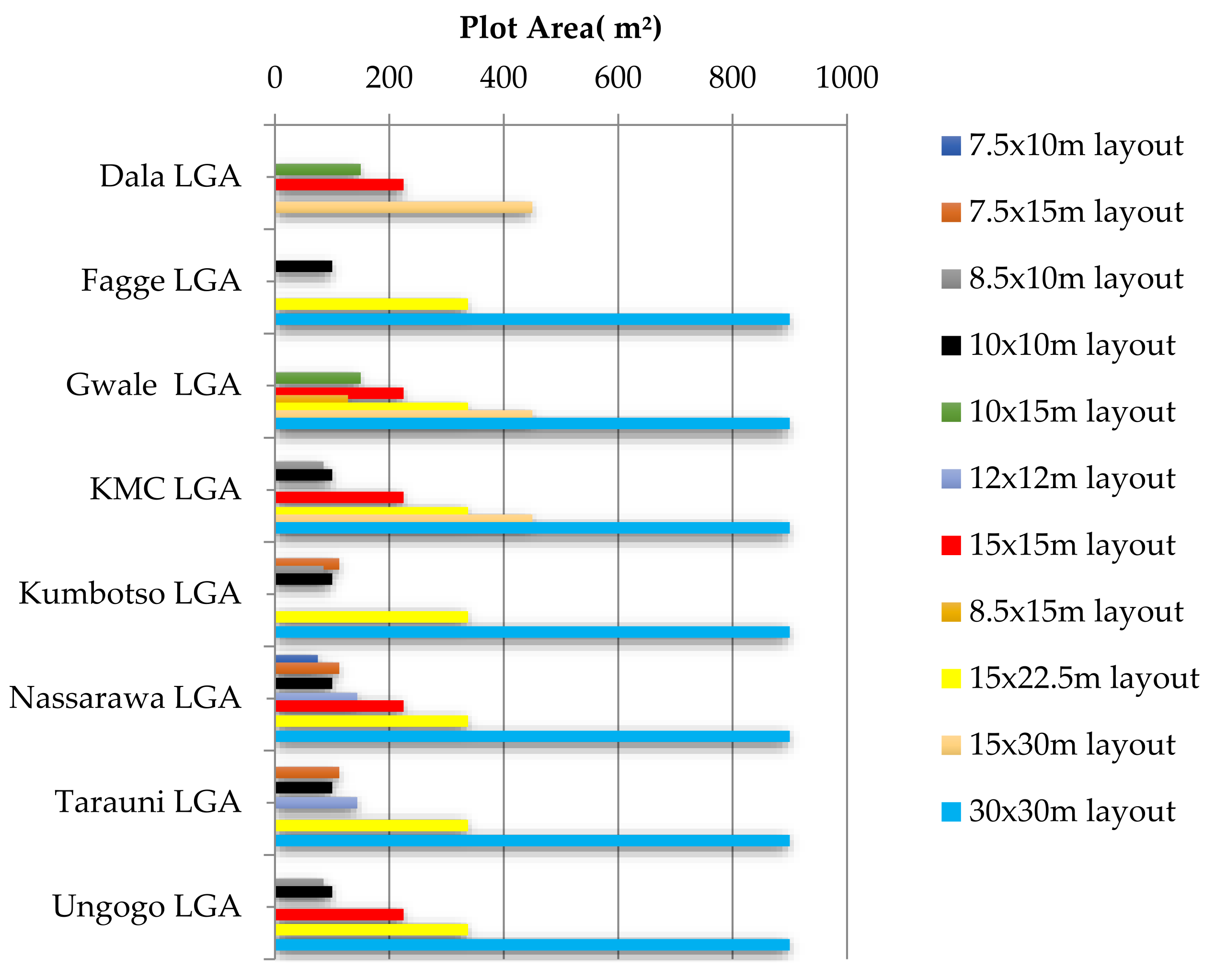
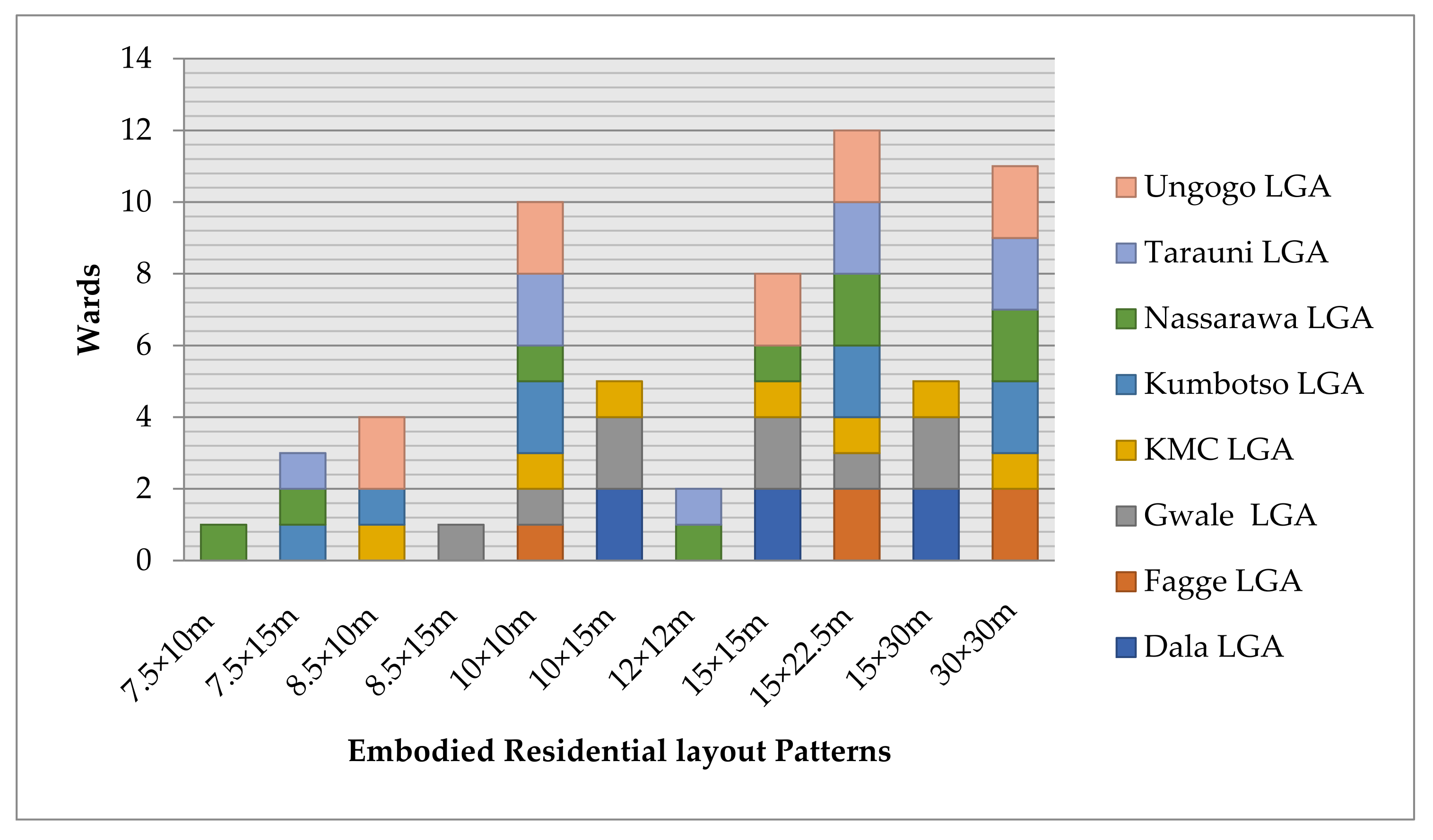
| Embodied Typology: | 10 × 15 m, 15 × 15 m and 15 × 30 mlayout patterns. |
| Kofar Mazugal | Over 86% of buildings are one-storey buildings in mud and brick. It is a typical traditional settlement with poor drainage, population congestion and other environmental hazards. The sample residence is transformed with organic, rectangular and square shapes. |
| Landscape forms: | The notable landmarks include Kofar Mazugal City Gate, Alhassan Dantata house, Yan Awaki Market/“Maitatsine” House. |
| Embodied Typology: | 96–913 m2; 10 × 15 m, 15 × 15 m and 15 × 30 m layout patterns. |
| Wards | Description |
|---|---|
| Fagge | One of the initial layouts by the colonial masters in the later 1950s, with over 92% one-storey buildings. Over 75% of the houses have a commercial shop at the exterior for tailoring, provisions, and so forth. Transformation is as a result of infrastructure construction, inheritance and socio-economic activities. |
| Landscape forms: | The notable landmarks include “kofofin Fagge” (the gates), “Dandali”, Kano Hajj camp, “Kwari” textile market, hospitals (M. Jidda and IDH), “Kudidifinwafa” (water pond), MAK International Airport, “Kwakwaci” green matrix, Jumm’at Mosque, a police station and courts. |
| Embodied Typology: | 10 × 10 m or 15 × 22.5 m, 30 × 30 m layout patterns. |
| Jabba | It has poor accessibility due to persistent soil erosion with a poor drainage system. The settlements show a remarkable 90% typical contemporary typology in most of the residential houses. Presently, it is facing flood risk due to an eroding coast toward the northeast end. It was transformed into a settlement due to the relocation scheme of residents or villagers from the area of the present Aminu Kano International Airport. |
| Landscape forms: | The notable landmarks include the military base/barracks and Aminu International Airport. |
| Embodied Typology: | 15 × 22.50 and 30 × 30 mm layout patterns. |
| Wards | Description |
|---|---|
| Gwale | Over 92% of the buildings are one-storey buildings in mud and brick. It is a typical traditional settlement with poor drainage, population congestion and a poor waste disposal system. Transformation is observed largely in the degradation of the old city wall and backfilling of some “Kudidifis” (water ponds)—“Kukkuъa” and “Mai Allo”. |
| Landscape forms: | The notable landmarks include Bayero University (BUK), Goron Dutse Hill, the old city wall and gates (Dan Agundi, Na’isa, Gadon Kaya, Fanfo, etc.), the ‘Haures’(Wanki, Shanu, etc.), graveyards, FCE Kano, Goron Dutse Prison and Galadanci Mosque. |
| Embodied Typology: | 96–913 m2; 10 × 15 m, 15 × 15 m and 15 × 30 m layout patterns. |
| Dorayi/Kabuga | Over 87% of the buildings are in contemporary bricks blocks and it is also among the indicators of measuring urban environmental quality, based on the minimum housing standard in Nigeria. |
| Landscape forms: | The notable landmarks include the Dorayi mini palace/farm house, “Kabuga” underpass, a pedestrian bridge by the old BUK site and “Jan Bulo”. |
| Embodied Typology: | 8.5 × 15 m, 15 × 15 m, 15 × 22.50 and 30 × 30 m layout patterns. |
| Wards | Description |
|---|---|
| Sharada | It consists of 94% contemporary buildings and 20% one-storey buildings, both in mud and cement brick with zinc sheet roofs, and houses plastered in cement with metal doors and windows. Generally, it consists of a traditional layout/houses, with 20% for renting to low-income earners, with unremarkable roads and poor drainage. It is a typical contemporary Hausa residential building settlement. Transformation is as a result of industrial infrastructure, construction and socio-economic activities. |
| Landscape forms: | The notable landmarks include an industrial estate, zone 1 police station, recreational facilities and religious places. |
| Embodied Typology: | 8.5 × 10 m, 10 × 10 m, 15 × 22.5 m, and 30 × 30 m layout patterns. |
| Yakasai | A total of 85% of the sample houses are one-storey buildings in mud and cement bricks. Due to an increase in population and lack of space for expansion, its houses are sub-divided due to inheritance, and renovated by new owners to suit their needs. In a contemporary archetype, it has sufficient vehicular access roads, but linked inter-connecting alleys (Hanya) with waste drainage in middle of the street. Transformation is observed largely in the degradation of the old city wall. |
| Landscape forms: | The notable landmarks include the “Rimi” market, Gidan Ma’aji and “kofar Nassarawa”, Investment House, Gidan Ado Bayero, “Gidan Murtala” and a fly-over. |
| Embodied Typology: | 96–913 m2; 10 × 15 m, 15 × 15 m and 15 × 30 m layout patterns. |
| Wards | Description |
|---|---|
| Challawa | It is located in a water-logged area with undulating terrain, poor sanitation and a poor drainage system. It is a typical squatter slum with 70% dilapidated buildings. Generally, 80% of the houses are designed for commercial purposes (renting) in one-storey buildings. |
| Landscape forms: | Transformations began with establishment of Kano State Water Works and manufacturing industries and now include socio-economic reasons.The notable landmarks include River Challawa, a water treatment plant, industrial estate and rail road. |
| Embodied Typology: | 8.5 × 10 m, 10 × 10 m, 15 × 22.5 m, 30 × 30 m layout patterns. |
| Kumbotso | Initially, there were Hausa and Fulani settlements with 90% of the buildings in mud plastered with cement, as well as 80% zinc roofs and 20% mud, and 95% cement screed floor finishing. Later, a modern settlement was established for irrigation farmers from the Kumbotso River from 1977–1982. |
| Landscape forms: | Transformations have to do with the establishment of manufacturing industries and residential estates. Notable landmarks are the River Kumbotso, “Dangwauro” Economic City, Sa’atu Rimi College of Education, residential estates (Kwankwasiyya, Amana and Almukab City) and some industrial expansion. |
| Embodied Typology: | 7.5 × 15 m, 10 × 10 m, 15 × 22.5 m, 30 × 30 m with sufficient wider road networks in grid patterns. |
| Wards | Description |
|---|---|
| Dakata/Kawaji/Badawa | Dakata/Kawaji are typical contemporary wards. They have a good planning layout by the government, with both major and minor roads, which are about 5–10 m wide, even though they have an acute water shortage. However, Badawa is typical ghetto settlement with undulating terrain, poor sanitation, and a poor drainage system. It is a typical squatter slum with 67% dilapidated buildings. Generally, 82% of the houses are designed for commercial purposes (renting) in one-storey buildings. |
| Landscape Forms: | Transformations began with the establishment of manufacturing Industries and for some socio-economic reasons. The notable landmarks include a fruit and vegetable Market, religious places, an industrial estate (Bompai industrial expansion) and rail roads. |
| Embodied Typology: | 7.5 × 10 m, 10 × 10 m, 15 × 15 m, 15 × 22.5 m, 30 × 30 m layout patterns. |
| Hotoro | A total of 95% of the Hotoro (arewa) buildings are contemporary houses, with 68% one-storey houses and almost 70% of the houses with cement block walls and zinc sheet. It also has fairly interconnected roads, but a poor drainage system, exposed to the street. There is no dump refuse point. Interestingly, it is the only ward with over 95% contemporary toilets rather than traditional pit latrines, despite the fact that they experience serious water shortages. |
| Landscape Forms: | Transformation began with the establishment of oil/gas filling stations and commercial shops for low-class business. In the early 20th century, a modern settlement (Ladanai and Tinshama) was purposely established for expansion. Notable landmarksare theNNPC mega-station underpass/flyover, Sani Abacha bypass, residential estates (Ladanai and Tinshama), religious places and some oil/gas filling stations (Chula, Nur, Majiya, Matrix, etc.). |
| Embodied Typology: | 7.5 × 15 m, 10 × 10 m, 12 × 12 m with moderate access, while the 15 × 22.5 m and 30 × 30 m comes with a sufficient road network in grid patterns. |
| Wards | Description |
|---|---|
| Babbangiji/Darmawa/Hausawa | Hausawa was established 150 years ago, and owners of farmland from the old city decided to migrate outside due to the problem of congestion in the city in 1972. A modern layout was established at Babbangiji in 1980s during Alhaji Abubakar Rimi’s administration, as the resettlement layout for people or occupants at the present Aminu Kano Teaching Hospital along the Zaria road. |
| Landscape Forms: | Transformation is as a result of infrastructural construction and socio-economic activities. The notable landmarks include Aminu Kano Teaching Hospital and Masallacin Murtala. |
| Embodied Typology: | 10 × 10 m or 15 × 22.5 m and 30 × 30 m layout patterns. |
| Unguwa Uku | A total of 79% of the houses are one-storey buildings with characteristic features of contemporary typologies. A total of 70% of the house are built with cement brick and covered with zinc sheets. It is considered as one of the sub-standard settlements in the Kano metropolitan area. |
| Landscape Forms: | Transformation is as a result of infrastructure construction and socio-economic activities. The ward is dominated by low-income earners such as traders, craftsmen and workers. The notable landmarks include the Yan Awaki Market, NNPC Depot and NNDC Quarters. |
| Embodied Typology: | 7.5 × 15 m, 10 × 10 m, 12 × 12 m have poor access, while the 15 × 22.5 m and 30 × 30 m are in grid patterns. |
| Wards | Description |
|---|---|
| Bachirawa | A total of 90% of the buildings are constructed in cement brick covered with zinc roofs, with modern design concepts and construction. The plot is laid out in a grid pattern planning system, with sufficient open space for lighting and ventilation. It is a typical contemporary building/archetype settlement, but with a poor drainage system. |
| Landscape Forms: | Transformation is as a result of infrastructure construction and socio-economic activities. The notable landmarks include the old NRC Secretariat (Bachirawa Hospital), a police outpost, religious places and filling stations. |
| Embodied Typology: | 8.5 × 10 m, 10 × 10 m, 15 m × 15 m or 15 × 22.5 m and 30 × 30 m layout patterns. |
| Ungogo | A total of 89% of the houses are built in traditional mud with “Azara”, plastered with cement on the walls and floors, and with a poor waste drainage system. The lack of economic activity and access roads limits its general development. The settlement is moderately populated due to a limitation in plot size for a specific family size, which makes it static in its physical development. Transformation is as a result of socio-economic activities. |
| Landscape Forms: | The notable landmarks includes the Fanisau mini palace and farm house, a technical college, Fanisau Hill and Kano free trade zone. |
| Embodied Typology: | 8.5 × 10 m, 10 × 10 m, 15 × 15 m, 15 × 22.5 m, and 30 × 30 m layout patterns. |
| S/No. | Local Governments | Ecological Landscapes | Cultural Landscapes | Scenic Points |
|---|---|---|---|---|
| 1. | Dala | Yan Awaki/Maitatsine house, market, “Kudidifi” (water pond), graveyard and abattoir (Mayanka) | Old City Wall and Gate (kofarruwa), Koki Zawiyya, Masaka Textile Factory (Gwammaja), Dala Hill, Yankilishi, Alfanda and Madabo settlements | Alhassan Dantata house, Federal Secretariat, Dala Orthopaedic Hospital, GGSS Dala, building material market (KofarRuwa) |
| 2. | Fagge | “Kudidifinwafa da na hajji camp” (water pond), “Kwakwaci” green matrix, graveyard and “Kwakwaci” flooded and eroded plain | “kofofinFagge” (the gates) and “Dandali” | Kano hajj camp, “kwari” textile market, Kano guest-in, hospitals (M. Jidda and IDH) Masallacin Jumm’a, police station and courts, military base/barracks andAminu International Airport |
| 3. | Gwale | GoronDutse Hill, “Kudidifi’s” (water ponds), the ‘Haures’ (Wanki, Shanu, etc.), graveyards, etc. | Dorayi mini palace, Old City Wall and Gates (Dan Agundi, Na’isa, Gadon Kaya, Fanfo, etc.) | Goron Dutse Prison and Galadanci Mosque, FCE Kano, Kabuga underpass, the pedestrian bridge by BUK old site and“Jan Bulo”. |
| 4. | Kano Municipal | “Rimi” market, “kofarNassarawa”, GidanMa’aji, old city wall | Investment House (Gidan Ado Bayero), “Gidan Murtala”, Sharada industrial estate, zone 1 police station, recreational facilities, religious places, “K. Nassarawa”(fly-over, fire service andMTD surveillance towers) | |
| 5. | Kumbotso | River Kumbotso, River Challawa, water treatment plant | Dangwauro” Economic City, Sa’atuRimi College of Education, residential estates (Kwankwasiyya, Amana and Almukab City) and some industrial expansion. | |
| 6. | Nassarawa | Fruit and vegetable market, “Bakindogo” graveyards | NNPC mega station, Sani Abacha bypass, residential estates (Ladanai andTinshama), industrial estate (Bompai industrial expansion) and rail roads. Religious places and some oil/gas filling stations. | |
| 7. | Tarauni | Yan Awaki Market (unguwauku) | Aminu Kano Teaching Hospital, NNPC Depot, NNDC Quarters and Masallacin Murtala. | |
| 8. | Ungogo | Fanisau Hill | Fanisau mini Palace | Former NRC secretariat (Bachirawa Hospital), police outpost, GTC Ungogo, Kano free trade zone, religious places and filling stations. |
Disclaimer/Publisher’s Note: The statements, opinions and data contained in all publications are solely those of the individual author(s) and contributor(s) and not of MDPI and/or the editor(s). MDPI and/or the editor(s) disclaim responsibility for any injury to people or property resulting from any ideas, methods, instructions or products referred to in the content. |
© 2023 by the authors. Licensee MDPI, Basel, Switzerland. This article is an open access article distributed under the terms and conditions of the Creative Commons Attribution (CC BY) license (https://creativecommons.org/licenses/by/4.0/).
Share and Cite
Yusuf, D.A.; Zhu, J.; Nashe, S.A.; Usman, A.M.; Sagir, A.; Yukubu, A.; Hamma, A.S.; Alfa, N.S.; Ahmed, A. A Typology for Urban Landscape Progression: Toward a Sustainable Planning Mechanism in Kano Metropolis, Nigeria. Urban Sci. 2023, 7, 36. https://doi.org/10.3390/urbansci7020036
Yusuf DA, Zhu J, Nashe SA, Usman AM, Sagir A, Yukubu A, Hamma AS, Alfa NS, Ahmed A. A Typology for Urban Landscape Progression: Toward a Sustainable Planning Mechanism in Kano Metropolis, Nigeria. Urban Science. 2023; 7(2):36. https://doi.org/10.3390/urbansci7020036
Chicago/Turabian StyleYusuf, Danjuma Abdu, Jie Zhu, Sadiq Abdullahi Nashe, Abdullahi Muhammad Usman, Abdullahi Sagir, Adamu Yukubu, Abdulmalik Sule Hamma, Namadi Sharif Alfa, and Abubakar Ahmed. 2023. "A Typology for Urban Landscape Progression: Toward a Sustainable Planning Mechanism in Kano Metropolis, Nigeria" Urban Science 7, no. 2: 36. https://doi.org/10.3390/urbansci7020036