
A Systematic Review of Applications of Machine Learning Techniques for Wildfire Management Decision Support


Abstract
:1. Introduction
Objective, Contribution, and Organization of the Work
- A summary of the applications developed by the studies mentioned;
- A classification according to the study type, main application of the model, machine learning technique, case study location, and performance metrics.
2. Systematic Review Methodology
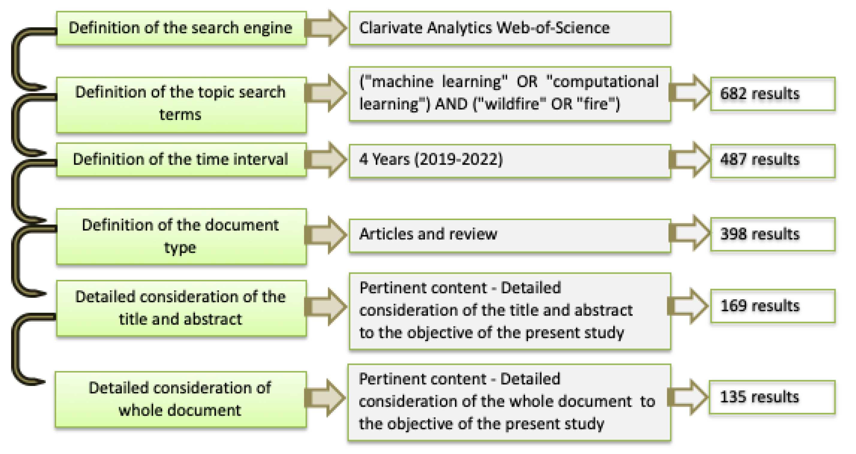
2.1. Database and Search Terms
2.2. Eligibility Criteria
2.3. Data Collection Results
3. Results
3.1. Related Reviews
3.2. Machine-Learning-Based Applications
3.2.1. Pre-Fire Prevention and Preparedness
Wildfire Fuel Modelling
Risk Assessment and Ignition Prediction of Wildfires
Support to Dispatch
Landscape Planning and Prevention Measures for Severity Mitigation
Development of Inventory Data
3.2.2. Management of Active Wildfires (Detection and Response)
Wildfire Detection
Wildfire Spread Prediction
Wildfire Suppression
3.2.3. Post-Fire Wildfires (Restoration and Adaptation Activities)
Burned Area and Severity
Impacts Related to Social Factors
Impacts Related to Carbon Fluxes
Impacts Related to Forest Conditions
3.3. Machine-Learning-Based Model Features and Feature Selection Sensitivity Analysis
3.4. Identified Research Trends and Challenges
- The increase in the use of ensemble modelling, which can reduce the inaccuracy and the computational time of the models by combining different models and machine learning techniques.
- The shifting focus from obtaining detailed physical interpretations to obtaining faster results based on input and output variables, especially at the stages in which the computational time of the modelling process is of critical importance, such as when dealing with active wildfires.
- The increasing concern with reducing the subjective bias associated with expert-opinion-based methods, as well as with incorporating uncertainty analysis at the modelling or sub-modelling stages.
- The use in many papers of the association of remote sensing imageries, machine learning, and geospatial analysis to predict or classify variables of interest, in order to identify areas that are prone to wildfire occurrence.
- The exploration of classification and prediction using the main machine learning methods of random forest, support vector machine, and neural networks.
- The use, in many documents, of the association of multiple methods to obtain a more accurate set of candidate models for the same area, to provide a more refined sampling and to choose a final model, indicating that the researchers are exploring an integrated approach to benefit from the capabilities of different methods to assess the complex problem of wildfire modelling.
- The need for constant improvement, mainly to obtain faster models while enhancing the interpretability of the results. This is still a critical factor in machine-learning-based models.
- Overall, the studies did not present the computational time associated with the modelling process, which is necessary to evaluate the applicability of the models in such an important field as disaster management.
- Few studies developed feature selection to increase the efficiency of decision support.
- Lack of information about simulation platforms, precluding the comparison of the computational efficiency of different tools.
- Lack of experience of using global models that can be applied to different regions and with different datasets and thus of assessing the potential for generalization of the models via a parametric study of bias–variance trade-offs.
- Few studies are available that focus on the multifunctionality of forested landscape management planning, i.e., on integrating wildfire protection concerns in contexts characterized by demands for multiple ecosystem services.
- There is almost no analysis on the bare minimum amount of data needed for a useful model, especially for the active wildfire stage.
- Despite the fact that some methods deal with uncertainty, when models encompass forecasting the uncertainty may be substantial, thus impacting the results (as in the case of models that consider weather features) associated with management prescriptions.
- There are still few datasets for extensive wildfires, and most of the models are developed using smaller wildfire events for training, which may not correctly reflect the context of extreme wildfire events.
- The acquisition of landscape dynamics data usually requires migrating data between datasets to quantify spatial patterns and changes through space and time. More developments are still required in this field.
- There may be issues regarding model overfitting that still need to be addressed.
- There is a need to bridge the gaps between monitorization and learning, and the decision-making process.
- There is a need for broader models that can help integrate the different wildfire management stages.
4. Conclusions
Author Contributions
Funding
Conflicts of Interest
References
- Malik, A.; Rao, M.R.; Puppala, N.; Koouri, P.; Thota, V.A.K.; Liu, Q.; Chiao, S.; Gao, J. Data-Driven Wildfire Risk Prediction in Northern California. Atmosphere 2021, 12, 109. [Google Scholar] [CrossRef]
- Carrasco, J.; Acuna, M.; Miranda, A.; Alfaro, G.; Pais, C.; Weintraub, A. Exploring the multidimensional effects of human activity and land cover on fire occurrence for territorial planning. J. Environ. Manag. 2021, 297, 113428. [Google Scholar] [CrossRef] [PubMed]
- Pais, C.; Miranda, A.; Carrasco, J.; Shen, Z.-J.M. Deep fire topology: Understanding the role of landscape spatial patterns in wildfire occurrence using artificial intelligence. Environ. Model. Softw. 2021, 143, 105122. [Google Scholar] [CrossRef]
- Banerjee, P. Maximum entropy-based forest fire likelihood mapping: Analysing the trends, distribution, and drivers of forest fires in Sikkim Himalaya. Scand. J. For. Res. 2021, 36, 275–288. [Google Scholar] [CrossRef]
- Rego, F.; Rigolot, E.; Fernandes, P.; Montiel, C.; Silva, J.S. Towards Integrated Fire Management. European Forest Institute Policy Brief 4; EFI: Joensuu, Finland, 2010; Available online: http//www.efi.int/files/attachments/publications/efi_policy_brief_4_en.pdf (accessed on 25 October 2021).
- Rego, F.M.C.C.; Rodríguez, J.M.M.; Calzada, V.R.V.; Xanthopoulos, G. Forest Fires: Sparking Firesmart Policies in the EU; European Comission: Brussel, Belgium, 2019. [Google Scholar]
- Botequim, B.; Fernandes, P.M.; Borges, J.G.; González-Ferreiro, E.; Guerra-Hernández, J. Improving silvicultural practices for Mediterranean forests through fire behaviour modelling using LiDAR-derived canopy fuel characteristics. Int. J. Wildl. Fire 2019, 28, 823–839. [Google Scholar] [CrossRef]
- Jain, P.; Coogan, S.C.P.; Subramanian, S.G.; Crowley, M.; Taylor, S.; Flannigan, M.D. A review of machine learning applications in wildfire science and management. Environ. Rev. 2020, 28, 478–505. [Google Scholar] [CrossRef]
- Botequim, B.; Fernandes, P.M.; Garcia-Gonzalo, J.; Silva, A.; Borges, J.G. Coupling fire behaviour modelling and stand characteristics to assess and mitigate fire hazard in a maritime pine landscape in Portugal. Eur. J. For. Res. 2017, 136, 527–542. [Google Scholar] [CrossRef]
- Marques, S.; Marto, M.; Bushenkov, V.; McDill, M.; Borges, J. Addressing wildfire risk in forest management planning with multiple criteria decision making methods. Sustainability 2017, 9, 298. [Google Scholar] [CrossRef] [Green Version]
- EU Horizon 2020 Work Programme 2018–2020 Cross-Cutting Activities; Publications Office of the European Union: Luxemburg, 2020; pp. 70–73.
- Pacheco, A.P.; Claro, J.; Fernandes, P.; de Neufville, R.; Oliveira, T.M.; Borges, J.G.; Rodrigues, J.C. Cohesive fire management within an uncertain environment: A review of risk handling and decision support systems. For. Ecol. Manag. 2015, 347, 1–17. [Google Scholar] [CrossRef]
- Moreira, F.; Ascoli, D.; Safford, H.; A Adams, M.; Moreno, J.M.; Pereira, J.C.; Catry, F.X.; Armesto, J.; Bond, W.J.; E González, M.; et al. Wildfire management in Mediterranean-type regions: Paradigm change needed. Environ. Res. Lett. 2019, 15, 011001. [Google Scholar] [CrossRef]
- Fernandes, P.; Botelho, H. Analysis of the prescribed burning practice in the pine forest of northwestern Portugal. J. Environ. Manag. 2004, 70, 15–26. [Google Scholar] [CrossRef] [PubMed]
- Rigolot, E. Predicting postfire mortality of Pinus halepensis Mill. and Pinus pinea L. Plant Ecol. 2004, 171, 139–151. [Google Scholar] [CrossRef]
- Marques, S.; Borges, J.G.; Garcia-Gonzalo, J.; Moreira, F.; Carreiras, J.; Oliveira, M.; Cantarinha, A.; Botequim, B.; Pereira, J.M.C. Characterization of wildfires in Portugal. Forstwiss. Cent. 2011, 130, 775–784. [Google Scholar] [CrossRef]
- Marques, S.; Garcia-Gonzalo, J.; Botequim, B.; Ricardo, A.; Borges, J.G.; Tomé, M.; Oliveira, M. Assessing wildfire occurrence probability in Pinus pinaster Ait. stands in Portugal. For. Syst. 2012, 21, 111. [Google Scholar] [CrossRef] [Green Version]
- Botequim, B.; Arias-Rodil, M.; Garcia-Gonzalo, J.; Silva, A.; Marques, S.; Borges, J.G.; Oliveira, M.M.; Tomé, M. Modeling Post-Fire Mortality in Pure and Mixed Forest Stands in Portugal—A Forest Planning-Oriented Model. Sustainability 2017, 9, 390. [Google Scholar] [CrossRef] [Green Version]
- Zhai, C.; Zhang, S.; Cao, Z.; Wang, X. Learning-based prediction of wildfire spread with real-time rate of spread measurement. Combust. Flame 2020, 215, 333–341. [Google Scholar] [CrossRef]
- Acuna, M.A.; Palma, C.D.; Cui, W.; Martell, D.L.; Weintraub, A. Integrated spatial fire and forest management planning. Can. J. For. Res. 2010, 40, 2370–2383. [Google Scholar] [CrossRef]
- Mell, W.E.; McDermott, R.J.; Forney, G.P. Wildland fire behavior modeling: Perspectives, new approaches and applications. In Proceedings of the 3rd Fire Behavior and Fuels Conference, Washington, DC, USA, 25–29 October 2010; pp. 25–29. [Google Scholar]
- Duff, T.J.; Tolhurst, K.G. Operational wildfire suppression modelling: A review evaluating development, state of the art and future directions. Int. J. Wildland Fire 2015, 24, 735. [Google Scholar] [CrossRef]
- Martell, D.L. A review of operational research studies in forest fire management. Can. J. For. Res. 1982, 12, 119–140. [Google Scholar] [CrossRef]
- Martell, D.L. A Review of Recent Forest and Wildland Fire Management Decision Support Systems Research. Curr. For. Rep. 2015, 1, 128–137. [Google Scholar] [CrossRef] [Green Version]
- El Naqa, I.; Murphy, M.J. What is machine learning? In Machine Learning in Radiation Oncology; Springer: Berlin/Heidelberg, Germany, 2015; pp. 3–11. [Google Scholar]
- Cunningham, P.; Cord, M.; Delany, S.J. Supervised learning. In Machine Learning Techniques for Multimedia; Springer: Berlin/Heidelberg, Germany, 2008; pp. 21–49. [Google Scholar]
- Muhammad, I.; Yan, Z. Supervised machine learning approaches: A survey. ICTACT J. Soft Comput. 2015, 5, 946–952. [Google Scholar] [CrossRef]
- Kelleher, J.D.; Mac Namee, B.; D’arcy, A. Fundamentals of Machine Learning for Predictive Data Analytics: Algorithms, Worked Examples, and Case Studies; MIT Press: Cambridge, MA, USA, 2020; ISBN 0262361108. [Google Scholar]
- Rish, I. An Empirical Study of the Naive Bayes Classifier. In Proceedings of the IJCAI 2001 Workshop on Empirical Methods in Artificial Intelligence, New York, NY, USA, 2 November 2001; Volume 3, pp. 41–46. [Google Scholar]
- Freund, Y.; Mason, L. The Alternating Decision Tree Learning Algorithm. In Proceedings of the ICML, San Francisco, CA, USA, 27–30 June 1999; Citeseer: University Park, PA, USA, 1999; Volume 99, pp. 124–133. [Google Scholar]
- Lewis, R.J. An Introduction to Classification and Regression Tree (CART) Analysis. In Proceedings of the Annual Meeting of the Society for Academic Emergency Medicine, San Francisco, CA, USA, 22–25 May 2000; Citeseer: University Park, PA, USA, 2000; Volume 14. [Google Scholar]
- Breiman, L. Random forests. Mach. Learn. 2001, 45, 5–32. [Google Scholar] [CrossRef] [Green Version]
- Miikkulainen, R.; Liang, J.; Meyerson, E.; Rawal, A.; Fink, D.; Francon, O.; Raju, B.; Shahrzad, H.; Navruzyan, A.; Duffy, N.; et al. Evolving Deep Neural Networks. In Artificial Intelligence in the Age of Neural Networks and Brain Computing; Elsevier BV: Amsterdam, The Netherlands, 2019; pp. 293–312. [Google Scholar]
- Wang, J.M.; Fleet, D.J.; Hertzmann, A. Gaussian Process Dynamical Models. In Proceedings of the NIPS, Cambridge, MA, USA, 5–8 December 2005; Citeseer: University Park, PA, USA, 2005; Volume 18, p. 3. [Google Scholar]
- Yegnanarayana, B. Artificial Neural Networks; PHI Learning Pvt. Ltd.: New Delhi, Índia, 2009; ISBN 8120312538. [Google Scholar]
- Sivanandam, S.N.; Deepa, S.N. Genetic algorithms. In Introduction to Genetic Algorithms; Springer: Berlin/Heidelberg, Germany, 2008; pp. 15–37. [Google Scholar]
- Mikolov, T.; Karafiát, M.; Burget, L.; Cernocký, J.; Khudanpur, S. Recurrent neural network based language model. In Proceedings of the Interspeech, Baltimore, MD, USA, 20 July 2010; Volume 2, pp. 1045–1048. [Google Scholar]
- Jaynes, E. On the rationale of maximum-entropy methods. Proc. IEEE 1982, 70, 939–952. [Google Scholar]
- Elith, J.; Leathwick, J.R.; Hastie, T. A working guide to boosted regression trees. J. Anim. Ecol. 2008, 77, 802–813. [Google Scholar] [CrossRef]
- Peterson, L.E. K-nearest neighbor. Scholarpedia 2009, 4, 1883. [Google Scholar] [CrossRef]
- Hearst, M.A.; Dumais, S.T.; Osuna, E.; Platt, J.; Scholkopf, B. Support vector machines. IEEE Intell. Syst. Their Appl. 1998, 13, 18–28. [Google Scholar] [CrossRef] [Green Version]
- Likas, A.; Vlassis, N.; Verbeek, J.J. The global k-means clustering algorithm. Pattern Recognit. 2003, 36, 451–461. [Google Scholar] [CrossRef] [Green Version]
- Kohonen, T. Self-Organizing Maps: Ophmization Approaches. In Artificial Neural Networks; Elsevier BV: Amsterdam, The Netherlands, 1991; pp. 981–990. [Google Scholar]
- Rasmussen, C.E. The infinite Gaussian mixture model. In Proceedings of the NIPS, Cambridge, MA, USA, 29 November–4 December 1999; Citeseer: University Park, PA, USA, 1999; Volume 12, pp. 554–560. [Google Scholar]
- Eddy, S.R. What is a hidden Markov model? Nat. Biotechnol. 2004, 22, 1315–1316. [Google Scholar] [CrossRef] [Green Version]
- Fritzke, B. Some Competitive Learning Methods; Ruhr University: Bochum, Germany, 1997. [Google Scholar]
- Belkina, A.C.; Ciccolella, C.O.; Anno, R.; Halpert, R.; Spidlen, J.; Snyder-Cappione, J.E. Automated optimized parameters for T-distributed stochastic neighbor embedding improve visualization and analysis of large datasets. Nat. Commun. 2019, 10, 1–12. [Google Scholar] [CrossRef] [Green Version]
- Miranda, A.; Carrasco, J.; González, M.; Pais, C.; Lara, A.; Altamirano, A.; Weintraub, A.; Syphard, A.D. Evidence-based mapping of the wildland-urban interface to better identify human communities threatened by wildfires. Environ. Res. Lett. 2020, 15, 094069. [Google Scholar] [CrossRef]
- Naderpour, M.; Rizeei, H.M.; Khakzad, N.; Pradhan, B. Forest fire induced Natech risk assessment: A survey of geospatial technologies. Reliab. Eng. Syst. Saf. 2019, 191, 106558. [Google Scholar] [CrossRef]
- Abid, F. A Survey of Machine Learning Algorithms Based Forest Fires Prediction and Detection Systems. Fire Technol. 2021, 57, 559–590. [Google Scholar] [CrossRef]
- Afonso, R.; Neves, A.; Damásio, C.V.; Pires, J.M.; Birra, F.; Santos, M.Y. Assessment of Interventions in Fuel Management Zones Using Remote Sensing. ISPRS Int. J. Geo-Inf. 2020, 9, 533. [Google Scholar] [CrossRef]
- Linn, R.; Winterkamp, J.; Furman, J.; Williams, B.; Hiers, J.; Jonko, A.; O’Brien, J.; Yedinak, K.; Goodrick, S. Modeling Low Intensity Fires: Lessons Learned from 2012 RxCADRE. Atmosphere 2021, 12, 139. [Google Scholar] [CrossRef]
- McCandless, T.C.; Kosovic, B.; Petzke, W. Enhancing wildfire spread modelling by building a gridded fuel moisture content product with machine learning. Mach. Learn. Sci. Technol. 2020, 1, 035010. [Google Scholar] [CrossRef]
- D’Este, M.; Elia, M.; Giannico, V.; Spano, G.; Lafortezza, R.; Sanesi, G. Machine Learning Techniques for Fine Dead Fuel Load Estimation Using Multi-Source Remote Sensing Data. Remote Sens. 2021, 13, 1658. [Google Scholar] [CrossRef]
- Lee, H.; Won, M.; Yoon, S.; Jang, K. Estimation of 10-Hour Fuel Moisture Content Using Meteorological Data: A Model Inter-Comparison Study. Forest 2020, 11, 982. [Google Scholar] [CrossRef]
- Chiang, C.-Y.; Barnes, C.; Angelov, P.; Jiang, R. Deep Learning-Based Automated Forest Health Diagnosis From Aerial Images. IEEE Access 2020, 8, 144064–144076. [Google Scholar] [CrossRef]
- Thurn, N.A.; Wood, T.; Williams, M.R.; Sigman, M.E. Classification of ground-truth fire debris samples using artificial neural networks. Forensic Chem. 2021, 23, 100313. [Google Scholar] [CrossRef]
- Sigman, M.E.; Williams, M.R.; Thurn, N.; Wood, T. Validation of Ground Truth Fire Debris Classification by Supervised Machine Learning. Forensic Chem. 2021, 100358. [Google Scholar] [CrossRef]
- Lauer, C.J.; A Montgomery, C.; Dietterich, T.G. Managing Fragmented Fire-Threatened Landscapes with Spatial Externalities. For. Sci. 2019, 66, 443–456. [Google Scholar] [CrossRef]
- Phelps, N.; Woolford, D.G. Comparing calibrated statistical and machine learning methods for wildland fire occurrence prediction: A case study of human-caused fires in Lac La Biche, Alberta, Canada. Int. J. Wildland Fire 2021. [Google Scholar] [CrossRef]
- Shirazi, Z.; Wang, L.; Bondur, V.G. Modeling Conditions Appropriate for Wildfire in South East China–A Machine Learning Approach. Front. Earth Sci. 2021, 9. [Google Scholar] [CrossRef]
- Campos-Vargas, C.; Vargas-Sanabria, D. Assessing the probability of wildfire occurrences in a neotropical dry forest. Écoscience 2021, 28, 159–169. [Google Scholar] [CrossRef]
- Eskandari, S.; Pourghasemi, H.R.; Tiefenbacher, J.P. Relations of land cover, topography, and climate to fire occurrence in natural regions of Iran: Applying new data mining techniques for modeling and mapping fire danger. For. Ecol. Manag. 2020, 473, 118338. [Google Scholar] [CrossRef]
- Xu, Z.; Liu, D.; Yan, L. Temperature-based fire frequency analysis using machine learning: A case of Changsha, China. Clim. Risk Manag. 2021, 31, 100276. [Google Scholar] [CrossRef]
- Janiec, P.; Gadal, S. A Comparison of Two Machine Learning Classification Methods for Remote Sensing Predictive Modeling of the Forest Fire in the North-Eastern Siberia. Remote Sens. 2020, 12, 4157. [Google Scholar] [CrossRef]
- Ghorbanzadeh, O.; Blaschke, T.; Gholamnia, K.; Aryal, J. Forest Fire Susceptibility and Risk Mapping Using Social/Infrastructural Vulnerability and Environmental Variables. Fire 2019, 2, 50. [Google Scholar] [CrossRef] [Green Version]
- Silva, I.; Valle, M.; Barros, L.; Meyer, J. A wildfire warning system applied to the state of Acre in the Brazilian Amazon. Appl. Soft Comput. 2020, 89, 106075. [Google Scholar] [CrossRef]
- Choi, M.-Y.; Jun, S. Fire Risk Assessment Models Using Statistical Machine Learning and Optimized Risk Indexing. Appl. Sci. 2020, 10, 4199. [Google Scholar] [CrossRef]
- Milanović, S.; Marković, N.; Pamučar, D.; Gigović, L.; Kostić, P.; Milanović, S. Forest Fire Probability Mapping in Eastern Serbia: Logistic Regression versus Random Forest Method. Forests 2020, 12, 5. [Google Scholar] [CrossRef]
- Kang, Y.; Jang, E.; Im, J.; Kwon, C.; Kim, S. Developing a New Hourly Forest Fire Risk Index Based on Catboost in South Korea. Appl. Sci. 2020, 10, 8213. [Google Scholar] [CrossRef]
- Kim, S.J.; Lim, C.-H.; Kim, G.S.; Lee, J.; Geiger, T.; Rahmati, O.; Son, Y.; Lee, W.-K. Multi-Temporal Analysis of Forest Fire Probability Using Socio-Economic and Environmental Variables. Remote Sens. 2019, 11, 86. [Google Scholar] [CrossRef] [Green Version]
- Bjånes, A.; De La Fuente, R.; Mena, P. A deep learning ensemble model for wildfire susceptibility mapping. Ecol. Inform. 2021, 65, 101397. [Google Scholar] [CrossRef]
- Tonini, M.; D’Andrea, M.; Biondi, G.; Degli Esposti, S.; Trucchia, A.; Fiorucci, P. A Machine Learning-Based Approach for Wildfire Susceptibility Mapping. The Case Study of the Liguria Region in Italy. Geosciences 2020, 10, 105. [Google Scholar] [CrossRef] [Green Version]
- Tehrany, M.S.; Jones, S.; Shabani, F.; Martínez-Álvarez, F.; Bui, D.T. A novel ensemble modeling approach for the spatial prediction of tropical forest fire susceptibility using LogitBoost machine learning classifier and multi-source geospatial data. Arch. Meteorol. Geophys. Bioclimatol. Ser. B 2019, 137, 637–653. [Google Scholar] [CrossRef]
- Achu, A.; Thomas, J.; Aju, C.; Gopinath, G.; Kumar, S.; Reghunath, R. Machine-learning modelling of fire susceptibility in a forest-agriculture mosaic landscape of southern India. Ecol. Inform. 2021, 64, 101348. [Google Scholar] [CrossRef]
- Gigović, L.; Pourghasemi, H.R.; Drobnjak, S.; Bai, S. Testing a New Ensemble Model Based on SVM and Random Forest in Forest Fire Susceptibility Assessment and Its Mapping in Serbia’s Tara National Park. Forests 2019, 10, 408. [Google Scholar] [CrossRef] [Green Version]
- Sánchez, M.B.; Tonini, M.; Mapelli, A.; Fiorucci, P. Spatial Assessment of Wildfires Susceptibility in Santa Cruz (Bolivia) Using Random Forest. Geosciences 2021, 11, 224. [Google Scholar] [CrossRef]
- PPham, B.T.; Jaafari, A.; Avand, M.; Al-Ansari, N.; Dinh Du, T.; Yen, H.P.H.; Phong, T.V.; Nguyen, D.H.; Le, H.V.; Mafi-Gholami, D.; et al. Performance Evaluation of Machine Learning Methods for Forest Fire Modeling and Prediction. Symmetry 2020, 12, 1022. [Google Scholar] [CrossRef]
- Eskandari, S.; Amiri, M.; Sãdhasivam, N.; Pourghasemi, H.R. Comparison of new individual and hybrid machine learning algorithms for modeling and mapping fire hazard: A supplementary analysis of fire hazard in different counties of Golestan Province in Iran. Nat. Hazards 2020, 104, 305–327. [Google Scholar] [CrossRef]
- Yousefi, S.; Pourghasemi, H.R.; Emami, S.N.; Pouyan, S.; Eskandari, S.; Tiefenbacher, J.P. A machine learning framework for multi-hazards modeling and mapping in a mountainous area. Sci. Rep. 2020, 10, 1–14. [Google Scholar] [CrossRef] [PubMed]
- Michael, Y.; Helman, D.; Glickman, O.; Gabay, D.; Brenner, S.; Lensky, I.M. Forecasting fire risk with machine learning and dynamic information derived from satellite vegetation index time-series. Sci. Total Environ. 2021, 764, 142844. [Google Scholar] [CrossRef] [PubMed]
- Mohajane, M.; Costache, R.; Karimi, F.; Pham, Q.B.; Essahlaoui, A.; Nguyen, H.; Laneve, G.; Oudija, F. Application of remote sensing and machine learning algorithms for forest fire mapping in a Mediterranean area. Ecol. Indic. 2021, 129, 107869. [Google Scholar] [CrossRef]
- Tuyen, T.T.; Jaafari, A.; Yen, H.P.H.; Nguyen-Thoi, T.; Van Phong, T.; Nguyen, H.D.; Van Le, H.; Phuong, T.T.M.; Nguyen, S.H.; Prakash, I.; et al. Mapping forest fire susceptibility using spatially explicit ensemble models based on the locally weighted learning algorithm. Ecol. Inform. 2021, 63, 101292. [Google Scholar] [CrossRef]
- Tang, X.; Machimura, T.; Li, J.; Liu, W.; Hong, H. A novel optimized repeatedly random undersampling for selecting negative samples: A case study in an SVM-based forest fire susceptibility assessment. J. Environ. Manag. 2020, 271, 111014. [Google Scholar] [CrossRef]
- Galizia, L.F.D.C.; Rodrigues, M. Modeling the Influence of Eucalypt Plantation on Wildfire Occurrence in the Brazilian Savanna Biome. Forests 2019, 10, 844. [Google Scholar] [CrossRef] [Green Version]
- Elia, M.; D’Este, M.; Ascoli, D.; Giannico, V.; Spano, G.; Ganga, A.; Colangelo, G.; Lafortezza, R.; Sanesi, G. Estimating the probability of wildfire occurrence in Mediterranean landscapes using Artificial Neural Networks. Environ. Impact Assess. Rev. 2020, 85, 106474. [Google Scholar] [CrossRef]
- Sayad, Y.O.; Mousannif, H.; Al Moatassime, H. Predictive modeling of wildfires: A new dataset and machine learning approach. Fire Saf. J. 2019, 104, 130–146. [Google Scholar] [CrossRef]
- Coughlan, R.; Di Giuseppe, F.; Vitolo, C.; Barnard, C.; Lopez, P.; Drusch, M. Using machine learning to predict fire-ignition occurrences from lightning forecasts. Meteorol. Appl. 2021, 28, e1973. [Google Scholar] [CrossRef]
- Naderpour, M.; Rizeei, H.; Ramezani, F. Forest Fire Risk Prediction: A Spatial Deep Neural Network-Based Framework. Remote Sens. 2021, 13, 2513. [Google Scholar] [CrossRef]
- Zhang, G.; Wang, M.; Liu, K. Forest Fire Susceptibility Modeling Using a Convolutional Neural Network for Yunnan Province of China. Int. J. Disaster Risk Sci. 2019, 10, 386–403. [Google Scholar] [CrossRef] [Green Version]
- Pourghasemi, H.R.; Gayen, A.; Lasaponara, R.; Tiefenbacher, J.P. Application of learning vector quantization and different machine learning techniques to assessing forest fire influence factors and spatial modelling. Environ. Res. 2020, 184, 109321. [Google Scholar] [CrossRef]
- Sharma, R.; Rani, S.; Memon, I. A smart approach for fire prediction under uncertain conditions using machine learning. Multimed. Tools Appl. 2020, 79, 28155–28168. [Google Scholar] [CrossRef]
- Bui, D.T.; Hoang, N.-D.; Samui, P. Spatial pattern analysis and prediction of forest fire using new machine learning approach of Multivariate Adaptive Regression Splines and Differential Flower Pollination optimization: A case study at Lao Cai province (Viet Nam). J. Environ. Manag. 2019, 237, 476–487. [Google Scholar] [CrossRef]
- Lattimer, B.; Hodges, J.; Lattimer, A. Using machine learning in physics-based simulation of fire. Fire Saf. J. 2020, 114, 102991. [Google Scholar] [CrossRef]
- Barreto, J.; Armenteras, D. Open Data and Machine Learning to Model the Occurrence of Fire in the Ecoregion of “Llanos Colombo–Venezolanos”. Remote Sens. 2020, 12, 3921. [Google Scholar] [CrossRef]
- Hogland, J.; Dunn, C.J.; Johnston, J.D. 21st Century Planning Techniques for Creating Fire-Resilient Forests in the American West. Forests 2021, 12, 1084. [Google Scholar] [CrossRef]
- Agarwal, P.; Tang, J.; Narayanan, A.N.L.; Zhuang, J. Big Data and Predictive Analytics in Fire Risk Using Weather Data. Risk Anal. 2020, 40, 1438–1449. [Google Scholar] [CrossRef] [PubMed]
- Yu, Y.; Mao, J.; Thornton, P.E.; Notaro, M.; Wullschleger, S.D.; Shi, X.; Hoffman, F.M.; Wang, Y. Quantifying the drivers and predictability of seasonal changes in African fire. Nat. Commun. 2020, 11, 1–8. [Google Scholar] [CrossRef] [PubMed]
- Thompson, M.P.; Gannon, B.M.; Caggiano, M.D. Forest Roads and Operational Wildfire Response Planning. Forests 2021, 12, 110. [Google Scholar] [CrossRef]
- Rodrigues, M.; Alcasena, F.; Vega-García, C. Modeling initial attack success of wildfire suppression in Catalonia, Spain. Sci. Total Environ. 2019, 666, 915–927. [Google Scholar] [CrossRef] [PubMed]
- He, Q.; Jiang, Z.; Wang, M.; Liu, K. Landslide and Wildfire Susceptibility Assessment in Southeast Asia Using Ensemble Machine Learning Methods. Remote Sens. 2021, 13, 1572. [Google Scholar] [CrossRef]
- Hanberry, B.B. Reclassifying the Wildland–Urban Interface Using Fire Occurrences for the United States. Land 2020, 9, 225. [Google Scholar] [CrossRef]
- Moustakas, A.; Davlias, O. Minimal effect of prescribed burning on fire spread rate and intensity in savanna ecosystems. Stoch. Environ. Res. Risk Assess. 2021, 35, 1–12. [Google Scholar] [CrossRef]
- Gholamnia, K.; Nachappa, T.G.; Ghorbanzadeh, O.; Blaschke, T. Comparisons of Diverse Machine Learning Approaches for Wildfire Susceptibility Mapping. Symmetry 2020, 12, 604. [Google Scholar] [CrossRef] [Green Version]
- Sulova, A.; Arsanjani, J.J. Exploratory Analysis of Driving Force of Wildfires in Australia: An Application of Machine Learning within Google Earth Engine. Remote Sens. 2021, 13, 10. [Google Scholar] [CrossRef]
- Ghorbanzadeh, O.; Kamran, K.V.; Blaschke, T.; Aryal, J.; Naboureh, A.; Einali, J.; Bian, J. Spatial Prediction of Wildfire Susceptibility Using Field Survey GPS Data and Machine Learning Approaches. Fire 2019, 2, 43. [Google Scholar] [CrossRef] [Green Version]
- Pérez-Porras, F.-J.; Triviño-Tarradas, P.; Cima-Rodríguez, C.; Meroño-De-Larriva, J.-E.; García-Ferrer, A.; Mesas-Carrascosa, F.-J. Machine Learning Methods and Synthetic Data Generation to Predict Large Wildfires. Sensors 2021, 21, 3694. [Google Scholar] [CrossRef]
- Yang, X.; Chen, R.; Zhang, F.; Zhang, L.; Fan, X.; Ye, Q.; Fu, L. Pixel-level automatic annotation for forest fire image. Eng. Appl. Artif. Intell. 2021, 104, 104353. [Google Scholar] [CrossRef]
- Govil, K.; Welch, M.L.; Ball, J.T.; Pennypacker, C.R. Preliminary Results from a Wildfire Detection System Using Deep Learning on Remote Camera Images. Remote Sens. 2020, 12, 166. [Google Scholar] [CrossRef] [Green Version]
- Shi, J.; Wang, W.; Gao, Y.; Yu, N. Optimal Placement and Intelligent Smoke Detection Algorithm for Wildfire-Monitoring Cameras. IEEE Access 2020, 8, 72326–72339. [Google Scholar] [CrossRef]
- Munshi, A. Fire Detection Methods Based on Various Color Spaces and Gaussian Mixture Models. Adv. Sci. Technol. Res. J. 2021, 15, 197–214. [Google Scholar] [CrossRef]
- Jang, E.; Kang, Y.; Im, J.; Lee, D.-W.; Yoon, J.; Kim, S.-K. Detection and Monitoring of Forest Fires Using Himawari-8 Geostationary Satellite Data in South Korea. Remote Sens. 2019, 11, 271. [Google Scholar] [CrossRef] [Green Version]
- Nguyen, M.D.; Vu, H.N.; Pham, D.C.; Choi, B.; Ro, S. Multistage Real-time Fire Detection using Convolutional Neural Networks and Long Short-term Memory Networks. IEEE Access 2021, 9, 146667–146679. [Google Scholar] [CrossRef]
- Liu, Z.; Zhang, K.; Wang, C.; Huang, S. Research on the identification method for the forest fire based on deep learning. Optik 2020, 223, 165491. [Google Scholar] [CrossRef]
- Rossi, R.; Gelfusa, M.; Malizia, A.; Gaudio, P. Adaptive Quasi-Unsupervised Detection of Smoke Plume by LiDAR. Sensors 2020, 20, 6602. [Google Scholar] [CrossRef] [PubMed]
- Saeed, F.; Paul, A.; Hong, W.H.; Seo, H. Machine learning based approach for multimedia surveillance during fire emergencies. Multimed. Tools Appl. 2020, 79, 16201–16217. [Google Scholar] [CrossRef]
- Saeed, F.; Paul, A.; Karthigaikumar, P.; Nayyar, A. Convolutional neural network based early fire detection. Multimed. Tools Appl. 2019, 79, 9083–9099. [Google Scholar] [CrossRef]
- Choi, M.; A Wi, J.; Kim, T.; Kim, Y.; Kim, C.-H. Learning Representation of Secondary Effects for Fire-Flake Animation. IEEE Access 2021, 9, 17620–17630. [Google Scholar] [CrossRef]
- Amici, S.; Piscini, A. Exploring PRISMA Scene for Fire Detection: Case Study of 2019 Bushfires in Ben Halls Gap National Park, NSW, Australia. Remote Sens. 2021, 13, 1410. [Google Scholar] [CrossRef]
- Ma, J.; Cheng, J.C.; Jiang, F.; Gan, V.J.; Wang, M.; Zhai, C. Real-time detection of wildfire risk caused by powerline vegetation faults using advanced machine learning techniques. Adv. Eng. Inform. 2020, 44, 101070. [Google Scholar] [CrossRef]
- Gibson, R.; Danaher, T.; Hehir, W.; Collins, L. A remote sensing approach to mapping fire severity in south-eastern Australia using sentinel 2 and random forest. Remote Sens. Environ. 2020, 240, 111702. [Google Scholar] [CrossRef]
- Imran; Iqbal, N.; Ahmad, S.; Kim, D. Towards Mountain Fire Safety Using Fire Spread Predictive Analytics and Mountain Fire Containment in IoT Environment. Sustainability 2021, 13, 2461. [Google Scholar] [CrossRef]
- Farguell, A.; Mandel, J.; Haley, J.; Mallia, D.; Kochanski, A.; Hilburn, K. Machine Learning Estimation of Fire Arrival Time from Level-2 Active Fires Satellite Data. Remote Sens. 2021, 13, 2203. [Google Scholar] [CrossRef]
- Hodges, J.L.; Lattimer, B.Y. Wildland Fire Spread Modeling Using Convolutional Neural Networks. Fire Technol. 2019, 55, 2115–2142. [Google Scholar] [CrossRef]
- McCarthy, N.; Tohidi, A.; Aziz, Y.; Dennie, M.; Valero, M.; Hu, N. A Deep Learning Approach to Downscale Geostationary Satellite Imagery for Decision Support in High Impact Wildfires. Forests 2021, 12, 294. [Google Scholar] [CrossRef]
- García-Llamas, P.; Suárez-Seoane, S.; Taboada, A.; Fernández-Manso, A.; Quintano, C.; Fernández-García, V.; Fernández-Guisuraga, J.M.; Marcos, E.; Calvo, L. Environmental drivers of fire severity in extreme fire events that affect Mediterranean pine forest ecosystems. For. Ecol. Manag. 2019, 433, 24–32. [Google Scholar] [CrossRef]
- Povak, N.A.; Kane, V.R.; Collins, B.M.; Lydersen, J.M.; Kane, J.T. Multi-scaled drivers of severity patterns vary across land ownerships for the 2013 Rim Fire, California. Landsc. Ecol. 2019, 35, 293–318. [Google Scholar] [CrossRef]
- Coffield, S.R.; Graff, C.A.; Chen, Y.; Smyth, P.; Foufoula-Georgiou, E.; Randerson, J.T. Machine learning to predict final fire size at the time of ignition. Int. J. Wildland Fire 2019, 28, 861–873. [Google Scholar] [CrossRef] [PubMed] [Green Version]
- Zohdi, T. A machine-learning framework for rapid adaptive digital-twin based fire-propagation simulation in complex environments. Comput. Methods Appl. Mech. Eng. 2020, 363, 112907. [Google Scholar] [CrossRef]
- Zohdi, T. A digital twin framework for machine learning optimization of aerial fire fighting and pilot safety. Comput. Methods Appl. Mech. Eng. 2021, 373, 113446. [Google Scholar] [CrossRef]
- Koklu, M.; Taspinar, Y.S. Determining the Extinguishing Status of Fuel Flames With Sound Wave by Machine Learning Methods. IEEE Access 2021, 9, 86207–86216. [Google Scholar] [CrossRef]
- Taspinar, Y.S.; Koklu, M.; Altin, M. Classification of flame extinction based on acoustic oscillations using artificial intelligence methods. Case Stud. Therm. Eng. 2021, 28, 101561. [Google Scholar] [CrossRef]
- Bhattarai, M.; Martinez-Ramon, M. A Deep Learning Framework for Detection of Targets in Thermal Images to Improve Firefighting. IEEE Access 2020, 8, 88308–88321. [Google Scholar] [CrossRef]
- Farasin, A.; Colomba, L.; Garza, P. Double-Step U-Net: A Deep Learning-Based Approach for the Estimation of Wildfire Damage Severity through Sentinel-2 Satellite Data. Appl. Sci. 2020, 10, 4332. [Google Scholar] [CrossRef]
- Montorio, R.; Pérez-Cabello, F.; Alves, D.B.; García-Martín, A. Unitemporal approach to fire severity mapping using multispectral synthetic databases and Random Forests. Remote Sens. Environ. 2020, 249, 249. [Google Scholar] [CrossRef]
- Hu, X.; Ban, Y.; Nascetti, A. Uni-Temporal Multispectral Imagery for Burned Area Mapping with Deep Learning. Remote Sens. 2021, 13, 1509. [Google Scholar] [CrossRef]
- Wang, S.S.; Qian, Y.; Leung, L.R.; Zhang, Y. Identifying Key Drivers of Wildfires in the Contiguous US Using Machine Learning and Game Theory Interpretation. Earth’s Futur. 2021, 9, e2020EF001910. [Google Scholar] [CrossRef]
- Collins, L.; McCarthy, G.; Mellor, A.; Newell, G.; Smith, L. Training data requirements for fire severity mapping using Landsat imagery and random forest. Remote Sens. Environ. 2020, 245, 111839. [Google Scholar] [CrossRef]
- García-Llamas, P.; Suárez-Seoane, S.; Fernández-Manso, A.; Quintano, C.; Calvo, L. Evaluation of fire severity in fire prone-ecosystems of Spain under two different environmental conditions. J. Environ. Manag. 2020, 271, 110706. [Google Scholar] [CrossRef]
- Xie, Y.; Peng, M. Forest fire forecasting using ensemble learning approaches. Neural Comput. Appl. 2019, 31, 4541–4550. [Google Scholar] [CrossRef]
- Bendick, R.; Hoylman, Z.H. Topological data analysis reveals parameters with prognostic skill for extreme wildfire size. Environ. Res. Lett. 2020, 15, 104039. [Google Scholar] [CrossRef]
- Al-Fugara, A.; Mabdeh, A.; Ahmadlou, M.; Pourghasemi, H.; Al-Adamat, R.; Pradhan, B.; Al-Shabeeb, A. Wildland Fire Susceptibility Mapping Using Support Vector Regression and Adaptive Neuro-Fuzzy Inference System-Based Whale Optimization Algorithm and Simulated Annealing. ISPRS Int. J. Geo-Inf. 2021, 10, 382. [Google Scholar] [CrossRef]
- Di Napoli, M.; Marsiglia, P.; Di Martire, D.; Ramondini, M.; Ullo, S.; Calcaterra, D. Landslide Susceptibility Assessment of Wildfire Burnt Areas through Earth-Observation Techniques and a Machine Learning-Based Approach. Remote Sens. 2020, 12, 2505. [Google Scholar] [CrossRef]
- Smith, C.; Panda, S.; Bhatt, U.; Meyer, F.; Badola, A.; Hrobak, J. Assessing Wildfire Burn Severity and Its Relationship with Environmental Factors: A Case Study in Interior Alaska Boreal Forest. Remote Sens. 2021, 13, 1966. [Google Scholar] [CrossRef]
- Carreiras, J.M.B.; Quegan, S.; Tansey, K.; Page, S. Sentinel-1 observation frequency significantly increases burnt area detectability in tropical SE Asia. Environ. Res. Lett. 2020, 15, 054008. [Google Scholar] [CrossRef]
- Wall, W.A.; Hohmann, M.G.; Just, M.G.; Hoffmann, W.A. Characterizing past fire occurrence in longleaf pine ecosystems with the Mid-Infrared Burn Index and a Random Forest classifier. For. Ecol. Manag. 2021, 500, 119635. [Google Scholar] [CrossRef]
- Stroppiana, D.; Bordogna, G.; Sali, M.; Boschetti, M.; Sona, G.; Brivio, P.A. A Fully Automatic, Interpretable and Adaptive Machine Learning Approach to Map Burned Area from Remote Sensing. ISPRS Int. J. Geo-Inf. 2021, 10, 546. [Google Scholar] [CrossRef]
- Hamilton, D.; Levandovsky, E.; Hamilton, N. Mapping Burn Extent of Large Wildland Fires from Satellite Imagery Using Machine Learning Trained from Localized Hyperspatial Imagery. Remote Sens. 2020, 12, 4097. [Google Scholar] [CrossRef]
- Hamilton, D.; Brothers, K.; Jones, S.; Colwell, J.; Winters, J. Wildland Fire Tree Mortality Mapping from Hyperspatial Imagery Using Machine Learning. Remote Sens. 2021, 13, 290. [Google Scholar] [CrossRef]
- Hamilton, D.; Brothers, K.; McCall, C.; Gautier, B.; Shea, T. Mapping Forest Burn Extent from Hyperspatial Imagery Using Machine Learning. Remote Sens. 2021, 13, 3843. [Google Scholar] [CrossRef]
- Bar, S.; Parida, B.R.; Pandey, A.C. Landsat-8 and Sentinel-2 based Forest fire burn area mapping using machine learning algorithms on GEE cloud platform over Uttarakhand, Western Himalaya. Remote Sens. Appl. Soc. Environ. 2020, 18, 100324. [Google Scholar] [CrossRef]
- Belenguer-Plomer, M.A.; Tanase, M.A.; Fernandez-Carrillo, A.; Chuvieco, E. Burned area detection and mapping using Sentinel-1 backscatter coefficient and thermal anomalies. Remote Sens. Environ. 2019, 233, 233. [Google Scholar] [CrossRef]
- Çömert, R.; Matci, D.K.; Avdan, U. Object based burned area mapping with random forest algorithm. Int. J. Eng. Geosci. 2019, 4, 78–87. [Google Scholar] [CrossRef]
- Jiang, Y.; Zhou, L.; Raghavendra, A. Observed changes in fire patterns and possible drivers over Central Africa. Environ. Res. Lett. 2020, 15, 0940b8. [Google Scholar] [CrossRef]
- Gelabert, P.J.; Montealegre, A.; Lamelas, M.; Domingo, D. Forest structural diversity characterization in Mediterranean landscapes affected by fires using Airborne Laser Scanning data. GIScience Remote Sens. 2020, 57, 497–509. [Google Scholar] [CrossRef]
- De Luca, G.; Silva, J.M.; Modica, G. A workflow based on Sentinel-1 SAR data and open-source algorithms for unsupervised burned area detection in Mediterranean ecosystems. GIScience Remote Sens. 2021, 58, 516–541. [Google Scholar] [CrossRef]
- Mpakairi, K.S.; Kadzunge, S.L.; Ndaimani, H. Testing the utility of the blue spectral region in burned area mapping: Insights from savanna wildfires. Remote Sens. Appl. Soc. Environ. 2020, 20, 100365. [Google Scholar] [CrossRef]
- Calp, M.H.; Kose, U. Estimation of burned areas in forest fires using artificial neural networks. Ing. Solidar. 2020, 16, 1–22. [Google Scholar] [CrossRef]
- Huang, Y.; Jin, Y.; Schwartz, M.W.; Thorne, J.H. Intensified burn severity in California’s northern coastal mountains by drier climatic condition. Environ. Res. Lett. 2020, 15, 104033. [Google Scholar] [CrossRef]
- Zou, Y.; O’Neill, S.M.; Larkin, N.K.; Alvarado, E.C.; Solomon, R.; Mass, C.; Liu, Y.; Odman, M.T.; Shen, H. Machine Learning-Based Integration of High-Resolution Wildfire Smoke Simulations and Observations for Regional Health Impact Assessment. Int. J. Environ. Res. Public Health 2019, 16, 2137. [Google Scholar] [CrossRef] [Green Version]
- Watson, G.L.; Telesca, D.; Reid, C.; Pfister, G.G.; Jerrett, M. Machine learning models accurately predict ozone exposure during wildfire events. Environ. Pollut. 2019, 254, 112792. [Google Scholar] [CrossRef] [PubMed]
- Oliveira, S.; Zêzere, J.L. Assessing the biophysical and social drivers of burned area distribution at the local scale. J. Environ. Manag. 2020, 264, 110449. [Google Scholar] [CrossRef] [PubMed]
- Sun, Q.; Meyer, W.S.; Koerber, G.R.; Marschner, P. Rapid recovery of net ecosystem production in a semi-arid woodland after a wildfire. Agric. For. Meteorol. 2020, 291, 108099. [Google Scholar] [CrossRef]
- Cruz-López, M.I.; Manzo-Delgado, L.D.L.; Aguirre-Gómez, R.; Chuvieco, E.; Equihua-Benítez, J.A. Spatial Distribution of Forest Fire Emissions: A Case Study in Three Mexican Ecoregions. Remote Sens. 2019, 11, 1185. [Google Scholar] [CrossRef] [Green Version]
- Shearman, T.M.; Varner, J.M.; Hood, S.M.; Cansler, C.A.; Hiers, J.K. Modelling post-fire tree mortality: Can random forest improve discrimination of imbalanced data? Ecol. Model. 2019, 414, 108855. [Google Scholar] [CrossRef]
- Addison, P.; Oommen, T.; Sha, Q. Assessment of post-wildfire debris flow occurrence using classifier tree. Geomat. Nat. Hazards Risk 2019, 10, 505–518. [Google Scholar] [CrossRef] [Green Version]
- Qiu, J.; Wang, H.; Shen, W.; Zhang, Y.; Su, H.; Li, M. Quantifying Forest Fire and Post-Fire Vegetation Recovery in the Daxing’anling Area of Northeastern China Using Landsat Time-Series Data and Machine Learning. Remote Sens. 2021, 13, 792. [Google Scholar] [CrossRef]
- Guz, J.; Gill, N.S.; Kulakowski, D. Long-term empirical evidence shows post-disturbance climate controls post-fire regeneration. J. Ecol. 2021, 109, 4007–4024. [Google Scholar] [CrossRef]
- Wang, J.; Zhang, X.; Rodman, K. Land cover composition, climate, and topography drive land surface phenology in a recently burned landscape: An application of machine learning in phenological modeling. Agric. For. Meteorol. 2021, 304-305, 108432. [Google Scholar] [CrossRef]
- Fernández-Guisuraga, J.M.; Verrelst, J.; Calvo, L.; Suárez-Seoane, S. Hybrid inversion of radiative transfer models based on high spatial resolution satellite reflectance data improves fractional vegetation cover retrieval in heterogeneous ecological systems after fire. Remote Sens. Environ. 2021, 255, 112304. [Google Scholar] [CrossRef]
- Baker, W.L. Restoration of forest resilience to fire from old trees is possible across a large Colorado dry-forest landscape by 2060, but only under the Paris 1.5 °C goal. Glob. Chang. Biol. 2021, 27, 4074–4095. [Google Scholar] [CrossRef] [PubMed]
- Cai, J.; Luo, J.; Wang, S.; Yang, S. Feature selection in machine learning: A new perspective. Neurocomputing 2018, 300, 70–79. [Google Scholar] [CrossRef]


| Ref. | Title | Addressed Issues |
|---|---|---|
| [8] | A review of machine learning applications in wildfire science and management | Overview of popular machine learning methods, review of applications and advantages and limitations of the methods |
| [49] | Forest fire induced Natech risk assessment: A survey of geospatial technologies | Review methods based on geospatial information systems (GIS) for modelling wildfire risk and their Natural Hazards Triggering Technological Disasters (Natech) potential |
| [50] | A Survey of Machine Learning Algorithms Based Forest Fires Prediction and Detection Systems | Review of various methods used in forest fires prediction and detection |
| Ref. | Classification 1 | Detailed Application | Machine Learning Technique | Case Study Location | Model Performance Metrics Results |
|---|---|---|---|---|---|
| [51] | A | Methods of Fuel Management Zone improvement | Extreme Gradient Boosting, Support Vector Machines, K-Nearest Neighbours, and Random Forest. | F1-score ranging from 90.0% up to 94.0% and a Kappa ranging from 0.80 up to 0.89. | |
| [53] | A | Determining fuel moisture content | Multiple Linear Regression, Random Forests, Gradient Boosted Regression, and Neural Networks | United States | Errors between 25.0–33.0% |
| [54] | A | Estimating fine dead fuel load and understand its determining factors | Multiple Linear Regression, Random Forest, and Support Vector Machine | Random Forest: RMSE: 0.09; MSE: 0.01; r: 0.71; R-2: 0.50) | |
| [55] | A | Estimating 10 h fuel moisture content | Random Forest and Support Vector Machine | (R-2= 0.77–0.82 and root mean squared error [RMSE] = 2.0–2.8%) | |
| [56] | A | Detection of dead trees from aerial images | Mask Region-Based Convolutional Neural Network | Mean average precision score = 54.0% | |
| [57] | A | Detection of ignitable liquids on ground-truth fire debris | Neural Networks | False positive rate of 0.07 and a true positive rate of 0.59 | |
| [58] | A | Detection of ignitable liquid residue on fire debris | Linear and Quadratic Discriminant Analysis, K-Nearest Neighbours, and Support Vector Machines with Radial and Linear Kernels | Area under the receiver operating characteristic curve (0.86–0.92), Equal error rates (17.0–22.0%) | |
| [60] | B | Methods for properly calibrating statistical and machine learning models for fine-scale, spatially explicit daily fire occurrence prediction | Classification Trees, Random Forests, Neural Networks, Logistic Regression Models, and Logistic Generalized Additive Models | Alberta, Canada | |
| [61] | B | Monitoring fire risks over a large region | Transductive PU Learning | Southeast China | High sensitivity (>80.0%) |
| [2] | B | Addressing the multidimensional effects of three groups of drivers in territorial planning under fire risk | Random Undersampling and Boosting | Chile | Area under the receiver operating characteristic curve of 0.967 and an overall accuracy over test data of 93.0% |
| [63] | B | Modelling fire danger | Support Vector Machine, Generalized Linear Model, Functional Data Analysis, and Random Forest | Iran | Area under the receiver operating characteristic curve of 0.855 |
| [64] | B | Analysing the influences of climate warming on fire risk | Random Forest, Support Vector Machine and Polynomial | Changsha, China | |
| [65] | B | Determining the risk of fire | Maxent and Random Forest | Yakutia, Russia | |
| [66] | B | Developing spatial prediction of wildfire susceptibility | Artificial Neural Network, Support Vector Machines, and Random Forest | Iran | Accuracies between 74.0–88.0% |
| [67] | B | Defining a long-term wildfire warning index | Fuzzy K-Nearest Neighbours | Brazil | |
| [68] | B | Optimizing risk indexing for fire risk assessment | Deep Neural Networks | Korea | |
| [69] | B | Determining the main explanatory variables for forest fire occurrence and mapping of probability | Random Forest | Eastern Serbia | |
| [70] | B | Developing an hourly forest fire risk index | CatBoost | South Korea | Area under the receiver operating characteristic curve = 0.8434 |
| [71] | B | Estimating and analysing how human activity is influencing forest fire probability | Maximum Entropy (Maxent) and Random Forest | South Korea | |
| [72] | B | Prediction of fire susceptibility and effects of sample patch sizes on the predictive performance of the algorithms | Deep Neural Network | Chile | Area under the curve = 0.953 |
| [73] | B | Elaborating a wildfire susceptibility map | Random Forests | Italy | |
| [74] | B | Developing a forest fire susceptibility map | LogitBoost Ensemble-Based Decision Tree | Vietnam | 92.0% prediction capability |
| [75] | B | Weighted approach to characterizing the forest fire susceptibility | Artificial Neural Network, Generalized Linear Model, Multivariate Adaptive Regression Splines, Naive Bayesian Classifier, K-Nearest Neighbour, Support Vector Machine, Random Forest, Gradient Boosting Machine, Adaptive Boosting, and Maximum Entropy (Maxent) | Kerala, India | Receiver operating characteristics—area under curve values ranging from 0.869 to 0.924 |
| [76] | B | Generating susceptibility maps of forest fires | Support Vector Machine, Random Forest, and Ensemble | Serbia | Ensemble model had an area under curve = 0.848 |
| [77] | B | Developing a model, in which probabilistic outputs allowed elaboration of wildfire susceptibility maps. | Random Forest | Bolivia | |
| [78] | B | Prediction and mapping of fire susceptibility | Bayes Network, Naive Bayes, Decision Tree, and Multivariate Logistic Regression | Pu Mat National Park, Nghe An Province, Vietnam | Area under curve = 0.96 |
| [79] | B | Predicting the fire hazard in a fire-prone area | Boosted Regression Tree, Classification and Regression Trees, Functional Discriminant Analysis, Generalized Linear Model, Mixture Discriminant Analysis, Random Forest | Northeast Iran, Golestan Province. | Area under curve = 0.855 |
| [80] | B | Producing an accurate multi-hazard risk map for a mountainous area | Support Vector Machine, Boosted Regression Tree, and Generalized Linear Model | Mountainous region of Iran | |
| [81] | B | Investigating the impact of satellite-derived metrics that represent long-term vegetation status and dynamics on fire risk mapping | Logistic Regression, Random Forest, and Extreme Gradient Boosting | Mediterranean woodlands and forests | |
| [82] | B | Mapping forest fire susceptibility | Frequency Ratio–Multilayer Perceptron, Frequency Ratio—Logistic Regression, Frequency Ratio–Classification and Regression Tree, Frequency Ratio–Support Vector Machine, and Frequency Ratio–Random Forest | North Morocco | Area under curve = 0.989 |
| [83] | B | Prediction of forest fire susceptibility | Locally Weighted Learning Algorithm with the Cascade Generalization, Bagging, Decorate, and Dagging Ensemble Learning | Vietnam | Area under curve = 0.993 |
| [84] | B | Computing the probability of hazard occurrence | Support Vector Machine and Genetic Algorithm | ||
| [85] | B | Predicting and detecting changes in the spatial pattern of ignition probability over time. | Random Forest | Brazil | Area under curve = 0.72 |
| [86] | B | Estimating wildfire probability occurrence as a function of biophysical and human-related drivers | Artificial Neural Network | Alpine and subalpine region | Area under curve = 0.68–0.72 |
| [87] | B | Predicting the occurrence of wildfires | Artificial Neural Network and Support Vector Machine | Prediction accuracy = 98.3% | |
| [3] | B | Estimating and predicting wildfire ignition risk | Deep Neural Network | ||
| [4] | B | Proposing forest fire prediction map | Maximum Entropy | Brazil and Australia | Area under curve = 0.95 |
| [1] | B | Predicting the wildfire risk | Random Forest | Monticello and Winters, California | Accuracy of 92.0% |
| [90] | B | Proposing a spatial prediction model for forest fire susceptibility | Convolutional Neural Network | Yunnan Province, China | Area under curve = 0.86 |
| [91] | B | Assessing forest fire susceptibility | Boosted Regression Tree, General Linear Model, and Mixture Discriminant Analysis | Fars Province, Iran | |
| [92] | B | Predicting occurrence of forest fires | Boosted Decision Trees, Decision Forest Classifier, Decision Jungle Classifier, Averaged Perceptron, 2-Class Bayes Point Machine, Local Deep Support Vector Machine, Logistic Regression, and Binary Neural Network | Area under the curve = 0.78 | |
| [93] | B | Analysing and predicting spatial patterns of forest fire danger | Multivariate Adaptive Regression Splines Optimized by Differential Flower Pollination | Lao Cai province (Vietnam) | Area under the curve = 0.91 |
| [94] | B | Providing details on specific techniques being explored for performing low-cost, high fidelity fire predictions | Deep Neural Networks | ||
| [60] | B | Developing methods for properly calibrating statistical and machine learning models for fine-scale, spatially explicit daily predictions | Classification Trees, Random Forests, Neural Networks, Logistic Regression Models, and Logistic Generalized Additive Models | Lac La Biche region of Alberta, Canada | |
| [95] | B | Estimating the probability of fire occurrence | Random Forest | Colombian–Venezuelan plains (llanos) ecoregion in South America. | Accuracy of 94.0% |
| [97] | B | Studying the impact of weather on the damage caused by fire incidents | Gradient Boosting Tree | United States | R-2 value of 0.933 and mean squared error (MSE) of 124.641 out of 10,000 |
| [98] | B | Prediction of African fire one month in advance and generalizing to provide seasonal estimates of regional and global fire risk | Stepwise Generalized Equilibrium Feedback Assessment | Africa | |
| [101] | D | Developing susceptibility maps considering the intersection of landslide and wildfire susceptibility and the spatial uncertainty | Random Forest, Gradient Boosting Decision Tree, and Adaptive Boosting | ||
| [104] | E | Creating wildfire inventory data by integrating the polygons collected through field surveys using global positioning systems (GPS) and the data collected from the moderate resolution imaging spectrometer (MODIS) thermal anomalies product | Artificial Neural Network, Dmine Regression, DM Neural, Least Angle Regression, Multi-Layer Perceptron, Random Forest, Radial Basis Function, Self-Organizing Maps, Support Vector Machine, and Decision Tree | ||
| [105] | E | Developing an automatized and cloud-based workflow for generating a training dataset of fire events at a continental level using freely available remote sensing data | Random Forest, Naive Bayes, and Classification and Regression Tree. | ||
| [106] | E | Creating a wildfire data inventory by integrating global positioning system (GPS) polygons with data collected from the moderate resolution imaging spectroradiometer (MODIS) thermal anomalies product | Artificial Neural Network, Support Vector Machines, and Random Forest | Amol County, northern Iran. |
| Ref. | Classification 1 | Detailed Application | Machine Learning Technique | Case Study Location | Model Performance Metrics Results |
|---|---|---|---|---|---|
| [110] | A | Proposing a two-module video smoke detection framework designed for embedded applications on local cameras | Lightweight Deep Convolutional Neural Network | ||
| [111] | A | Proposing an intelligent fire detection method by investigating three approaches to detect fire based on three different colour models | Decision Rule and Gaussian Mixture Model | ||
| [112] | A | Proposing a combined 3-step forest fire detection algorithm (i.e., thresholding, machine-learning-based modelling, and post-processing) | Random Forest | South Korea | Overall accuracy similar to 99.2%, probability of detection |
| [113] | A | Proposing a multistage fire detection method | Convolutional Neural Networks and Long Short Term Memory Networks | ||
| [114] | A | Proposing a multi-level forest fire detection method | General Advanced Networks, Adaptive Boosting, Convolutional Neural Networks, and Support Vector Machine | ||
| [116] | A | Proposing a method using machine learning techniques for multimedia surveillance during fire emergencies | Adaptive Boosting and Many Multi-Layer Perceptron Neural Networks | ||
| [117] | A | Proposing a fire detection method using sensors and image data | Adaptive Boosting, Multi-Layer Perceptron Neural Networks, and Convolutional Neural Networks | ||
| [118] | A | Proposing a data-driven fire-flake simulation model | Neural Network | ||
| [119] | A | Exploring the potential use of the PRISMA sensor for active wildfire characterization | Support Vector Machine | New South Wales | |
| [108] | A | Proposing a method that widens the view of fire detection from conventional two-class to multi-class classification problems to meet complex forest image background | K-Nearest Neighbour Decision Tree | ||
| [120] | A | Exploring and discovering the numerical patterns from the contact to the ignition process between different upper-storey vegetations and the powerlines | Hybrid Step Extreme Gradient Boosting | ||
| [61] | A | Developing a workflow process to monitor fires over a large region | Transductive PU Learning | Southeast China | |
| [121] | A | Systematically testing and comparing reflectance and fractional cover candidate severity indices | Random Forest | ||
| [123] | B | Estimating the fire arrival time from satellite data | Support Vector Machine | California, United States | 12.0% burned area absolute percentage error; 5.0% total burned area mean percentage error, a 0.21 false alarm ratio average, a 0.86 probability of detection average, and a 0.82 Sorensen’s coefficient average |
| [124] | B | Estimating the time-resolved spatial evolution of a wildland fire front | Deep Convolutional Inverse Graphics Network | ||
| [125] | B | Developing a fire progression model considering the uncertainties | U-Net Convolutional Neural Network | ||
| [126] | B | Identifying the main environmental factors driving fire severity in extreme fire events | Random Forest | California, USA | |
| [128] | B | Investigating the controls and predictability of final fire size at the time of ignition | Decision Tree | 50.4+/−5.2% accuracy | |
| [131] | C | Creating a sound-wave fire-extinguishing system and performing firefighting tests | Artificial Neural Network, K-Nearest Neighbour, Random Forest, Stacking, and Deep Neural Network Methods | ||
| [132] | C | Developing a sound-wave flame extinction system in order to extinguish the flames at an early stage of the fire | Adaptive-Network-Based Fuzzy Inference Systems), CN2 Rule and DT (Decision Tree) | ||
| [133] | C | Creating an automated system that is capable of real-time, intelligent object detection and recognition and facilitating the improved situational awareness of firefighters during an emergency response | Convolutional Neural Network |
| Ref. | Classification 1 | Detailed Application | Machine Learning Technique | Case study Location | Model Performance Metrics Results |
|---|---|---|---|---|---|
| [137] | A | Incorporating predictors of local meteorology, land-surface characteristics, and socio-economic variables to predict monthly burned area | Shapley Additive Explanation | United States | |
| [138] | A | Examining how training data properties affect fire severity classification across forest, woodland, and shrubland communities | Southern Australia | ||
| [139] | A | Determining the main environmental variables that control fire severity in large fires | Random Forest | Iberian Peninsula | |
| [140] | A | Predicting the burned area of forest fires and the occurrence of large-scale forest fires | Portugal | ||
| [141] | A | Topological data analysis to assess the final burned area | United States | ||
| [142] | A | Mapping wildland fires | Support Vector Regression and the Adaptive Neuro-Fuzzy Inference System | Jerash Province, Jordan | |
| [143] | A | Determining relationships existing between the triggering of landslides and burnt areas through processing of the thematic maps of the burnt areas and landslide susceptibility assessment | |||
| [136] | A | Developing models for automatically mapping burned areas from unitemporal multispectral imagery | |||
| [144] | A | Assessing burn severity across the burn scars and testing the effectiveness of several remote sensing methods for generating accurate map products | Random Forest and Support Vector Machine | Interior of Alaska | |
| [145] | A | Mapping of burned areas using microwave data | Random Forests | ||
| [146] | A | Identifying burned areas and estimating the fire history | Random Forest | North Carolina, United States | |
| [147] | A | Using automatic algorithm approach to map burned areas from remote sensing | |||
| [148] | A | Examining the use of sUAS imagery to train and validate burn severity and extent mapping of large wildland fires from various satellite images | |||
| [149] | A | Calculating tree mortality through the comparison of hyperspatial post-fire canopy cover and pre-fire canopy cover | Mask Region-Based Convolutional Neural Network | ||
| [150] | A | Determining trees and burned pixels in a post-fire forest | Mask Region-Based Convolutional Neural Network and Support Vector Machine | ||
| [151] | A | Analysing bi-temporal (pre- and post-fire) reflectance contrast of burn-sensitive spectral bands | Classification Regression Tree, Random Forest, and Support Vector Machine | ||
| [155] | A | Mapping burned and unburned areas, differentiating fire occurrence dates, and distinguishing between old and more recent fires | K-Nearest Neighbours Algorithm (K-NN), Support Vector Machine (SVM) And Random Forest | Mediterranean area | |
| [156] | A | Investigates the use capability of the free synthetic aperture radar data for burned area mapping | Portugal and Italy | ||
| [157] | A | Test the applicability of a normalized difference spectral index with the shortwave infrared and blue spectral bands in accurately mapping burned areas | Random Forest | ||
| [158] | A | Estimating burned areas in forest fires | Artificial Neural Network | ||
| [159] | A | Examine the fine-scale association between burn severity and a suite of environmental drivers | Random Forest | California, United States | Accuracy of 79.0% in classifying categories of burn severity |
| [160] | B | Evaluate public health impacts of wildfire smoke | Ordinary Multi-Linear Regression Method, Generalized Boosting Method, and Random Forest | United States | |
| [161] | B | Prediction models for ground-level ozone during wildfires, evaluating the predictive accuracy | California, United States | ||
| [162] | B | Explored different combinations of biophysical and social factors to characterize wildfire-affected areas | Classification Trees | Portugal | |
| [163] | C | The carbon flux of the woodland was monitored to simulate daily net ecosystem production, ecosystem respiration, and gross primary production | |||
| [164] | C | Calculating emissions associated with forest fires in Mexico, based on different satellite observation products | Random Forest | Mexico and United States | |
| [135] | D | Proposes a unitemporal simulation approach based on the generation of synthetic spectral databases from linear spectral mixing to classify wildfire severity | Random Forest | Spain | Accuracy between 90.0–95.0% |
| [165] | D | Prediction of post-fire tree mortality | Random Forest | Reduced the bias in comparison with logistic regression method | |
| [166] | D | Focus on the post-fire debris flow hazards analysis | Decision Tree Algorithm | Sensitivity of 81.0% and specificity of 78.0% | |
| [167] | D | Map forest disturbance after a wildfire | Multiple Linear Regression, Support Vector Machine, and Random Forest | Northeastern China | |
| [168] | D | Identify temporal trends in post-fire regeneration and influences of climate on post-fire regeneration, with focus on post-fire establishment, initial post-fire density and radial growth | |||
| [169] | D | Assessed the contributions of land cover composition, climate, and topography on the spatial forest regeneration | Boosted Regression Trees | New Mexico, United States | |
| [170] | D | Evaluate the potential of a radiative transfer model inversion approach for estimating fractional vegetation cover after wildfire from satellite reflectance data at high spatial resolution | Gaussian Processes Regression | Mediterranean Basin | |
| [171] | D | Assessed whether passive restoration of old trees could overcome constraints in time | Random Forest | Colorado, United States |
Publisher’s Note: MDPI stays neutral with regard to jurisdictional claims in published maps and institutional affiliations. |
© 2022 by the authors. Licensee MDPI, Basel, Switzerland. This article is an open access article distributed under the terms and conditions of the Creative Commons Attribution (CC BY) license (https://creativecommons.org/licenses/by/4.0/).
Share and Cite
Bot, K.; Borges, J.G. A Systematic Review of Applications of Machine Learning Techniques for Wildfire Management Decision Support. Inventions 2022, 7, 15. https://doi.org/10.3390/inventions7010015
Bot K, Borges JG. A Systematic Review of Applications of Machine Learning Techniques for Wildfire Management Decision Support. Inventions. 2022; 7(1):15. https://doi.org/10.3390/inventions7010015
Chicago/Turabian StyleBot, Karol, and José G. Borges. 2022. "A Systematic Review of Applications of Machine Learning Techniques for Wildfire Management Decision Support" Inventions 7, no. 1: 15. https://doi.org/10.3390/inventions7010015