Article

Toward a Spatially Segregated Urban Growth? Austerity, Poverty, and the Demographic Decline of Metropolitan Greece

1
Department of Sociology, University of the Aegean, Mitilini Hill, EL-81100 Lesvos, Greece
2
Department of Agriculture and Forest Sciences, University of Tuscia, Via S. Camillo De Lellis, I-01110 Viterbo, Italy
3
Department of Methods and Models for Economics, Territory and Finance, Faculty of Economics, Sapienza University of Rome, Via del Castro Laurenziano 9, I-00161 Rome, Italy
*
Author to whom correspondence should be addressed.
Submission received: 15 November 2022 / Revised: 21 February 2023 / Accepted: 24 February 2023 / Published: 1 March 2023
(This article belongs to the Special Issue Data-Driven Approach on Urban Planning and Smart Cities)

Abstract

:
Metropolitan decline in southern Europe was documented in few cases, being less intensively investigated than in other regions of the continent. Likely for the first time in recent history, the aftermath of the 2007 recession was a time period associated with economic and demographic decline in Mediterranean Europe. However, the impacts and consequences of the great crisis were occasionally verified and quantified, both in strictly urban contexts and in the surrounding rural areas. By exploiting official statistics, our study delineates sequential stages of demographic growth and decline in a large metropolitan region (Athens, Greece) as a response to economic expansion and stagnation. Having important implications for the extent and spatial direction of metropolitan cycles, the Athens’ case—taken as an example of urban cycles in Mediterranean Europe—indicates a possibly new dimension of urban shrinkage, with spatially varying population growth and decline along a geographical gradient of income and wealth. Heterogeneous dynamics led to a leapfrog urban expansion decoupled from agglomeration and scale, the factors most likely shaping long-term metropolitan expansion in advanced economies. Demographic decline in urban contexts was associated with multidimensional socioeconomic processes resulting in spatially complex demographic outcomes that require appropriate, and possibly more specific, regulation policies. By shedding further light on recession-driven metropolitan decline in advanced economies, the present study contributes to re-thinking short-term development mechanisms and medium-term demographic scenarios in Mediterranean Europe.

1. Introduction

Urbanization and suburbanization stages were (and still are) regarded as the main engine of metropolitan expansion and decline for most agglomerations in the world [1,2,3]. The inherent limitations of economic theories and empirical frameworks identifying and profiling metropolitan cycles [4] justify a novel investigation of (regional) demographic patterns and processes that integrates multi-disciplinary perspectives—going beyond the quantitative analysis of economic dynamics and approaching the social complexity of local communities more tightly [5,6,7,8]. Taken as the primary factor at the base of urban growth [9], population dynamics in Europe have been increasingly analyzed along the ‘metropolitan continuum’ [10], and are being interpreted as the result of economic attractiveness and local development in contemporary regions [11,12,13]. However, recent demographic scenarios open up a reflection on the intimate processes of metropolitan growth and change [14], moving from exquisitely economic mechanisms of settlement expansion to mixed drivers oriented toward social specificities and territorial heterogeneity [15,16,17].
Recession accompanied the decline of agglomeration economies, sometimes leading to counter-urbanization [18,19,20]. As an indirect result of counter-urbanization, the population increased in peripheral areas [21], suggesting how demographic patterns were progressively decoupled from agglomeration dynamics and scale economies [22]. In a post-crisis context, a refined investigation of the negative impacts of recession on local socioeconomic structures may shed further light on present and future population dynamics [23,24,25]. The notion of ‘urban shrinkage’ was associated with areas that undergo depopulation for a variety of complex processes, all of which require different responses and plans [26,27,28]. Although recent studies were increasingly focused on a refined comprehension of the role of population aging, economic stagnation, and intentional (e.g., policy-driven) shrinkage to improve quality of life [29], industrial decline remains a key factor of demographic contraction in metropolitan regions [30,31,32]. In these regards, the Great Recession was assumed as a powerful driver of shrinkage [33]—although relatively few studies were devoted to quantify the prolonged effect of a global economic crisis at the local level [34,35,36].
Urban shrinkage is a particularly heterogeneous issue in advanced economies [37]. Following a continuous expansion of dense and dispersed settlements as a result of population growth and the spread of activities across suburban districts, cities—and especially large cities—in some European countries started declining as far as demography and wealth are concerned [38,39,40]. Taken as a typical outcome of suburbanization—driving people that resided downtown to move to suburbs with the aim of finding better environmental and housing conditions—core cities were initially involved in such dynamics. More recently, suburbs were involved in processes that reflect an incipient ‘counterurbanization’ (i.e., people coming back to rural settlements), or, more frequently, a particularly unfavorable development path at the regional scale (e.g., [41]). Based on a generalized growth/shrinkage index for metropolitan areas released by OECD regional statistics, Table 1 shows the evolution of growing (or declining) metropolitan areas in selected European countries, evaluating the last two decades (2001–2011 and 2011–2021) separately.
Considering a total of 231 metropolitan areas in 24 European countries, nearly half of the countries (11 out of 24) in the sample had no shrinking cities and a significantly positive average index of metropolitan growth over both 2001–2011 and 2011–2021. These countries were representative of all European macro-regions, with the predominance of western and central Europe. A small (<50%) percentage of shrinking cities was observed in another six countries (the United Kingdom, Turkey, the Netherlands and Czech Republic, Denmark, and Poland). Percentages around 50% (and systematically negative (average) values of the OECD index) were observed in seven countries with a peripheral location in Europe (Greece and Portugal in southern Europe; Hungary, Romania, and Bulgaria in eastern Europe; and Latvia and Lithuania in northeastern Europe). Urban shrinkage in such contexts reflects economic decline in countries already disadvantaged and less dynamic than the European core, thanks to a marginal location in the Union, low accessibility because of a lack of infrastructures, and decelerated wealth accumulation driven by regional and local factors [42,43,44]. Interestingly, this empirical exercise demonstrates how urban shrinkage—originally observed in some economically backward contexts of eastern Europe, following the long transition from socialist regimes to market-oriented models—spread in other socioeconomic contexts both toward the north (Baltic countries) and the south (Mediterranean countries).
In southern Europe, urban decline was particularly infrequent up to ten years ago, since a marked demographic dynamism (e.g., positive natural balance and intense immigration flows) was characteristic of most cities in this region [45,46,47]. A progressive mismatch between population growth, demographic dynamics, household structure, and settlement preferences makes an understanding of the mechanisms governing metropolitan development (and causing urban shrinkage) a particularly hard task in Mediterranean Europe [48,49,50]. This important socioeconomic process requires a more precise definition of both the demographic phenomena at the base of recent shrinkage and the socioeconomic, territorial, and policy implications at large [51,52,53] With this perspective in mind, studies providing an operational example of the integrated use of multiple data sources for a more comprehensive scrutiny of complex socioeconomic issues seem to be timely and appropriate. Thanks to an ever growing information base because of improvements in official statistics and digital (public) data sources (including the ‘open data’ initiatives strongly promoted by the INSPIRE directive at the European level), the present study shows the potentiality of integrating multiple official statistics for the continuous assessment of metropolitan growth—assumed as a complex phenomenon evolving rapidly over time in less predictable directions than observed in the past.
More specifically, our study reviews and scrutinizes, in a comparative perspective, the official statistics derivable from both public authorities of Greece (e.g., ELSTAT) and, more generally, the European Union (e.g., Eurostat), demonstrating that a careful integration of multiple data sources may provide an enhanced description of urban change, metropolitan growth, and the consequent demographic trends vis à vis socioeconomic transformations. We intended our approach as eminently descriptive and exploratory and, despite being quite simplified, our perspective seems to be—to the best of our knowledge—one of the first contributions to the current literature documenting urban change and demographic trends before, during, and after the great crisis, with a tentative exploration of the impact of more recent shocks, namely the COVID-19 pandemic in 2020–2021. The selection of the case study (metropolitan Athens, Greece) is fully justified in light of this rationale: Athens was one of the cities more impacted by the 2007 crisis in the European panorama, possibly more than similar socioeconomic contexts in Mediterranean Europe, and surely more than several other cities in Portugal, Spain, or Italy [14,45,54]. While the descriptive and exploratory nature of our study still represents an original contribution to urban studies, applied demography, and regional science, investigating the latest trends in metropolitan decline referring to such a context—considering Athens as a paradigmatic and representative case—may provide further insight toward a comprehensive understanding of the mechanisms at the base of urban shrinkage in Mediterranean Europe [55,56].
Making an extensive use of official statistics, our study aims at evidencing similarities and differences with other peripheral countries in Europe and, more generally, in other advanced economies outside Europe [57,58,59]. A secondary objective of this study is to demonstrate the validity of a descriptive approach based on multiple official statistics and thematic indicators that allows a practical investigation of short-term dynamics typically observed in the study area. Going beyond the traditional assumption of the city life cycle (e.g., [14]), our study re-visits the main development stages of a representative metropolitan region in southern Europe, offering an alternative interpretation of population growth as a competition process among local districts. In other words, we assume that such districts indirectly compete to attract (or push out) populations on the basis of their intrinsic endowments (accessibility, services, the local job market, amenities), namely their ‘territorial capital’ [60]. Such dynamics reflect broader trends at the regional and country scale. When comparing long-term and short-term population dynamics over a metropolitan cycle, Greece—and its capital region, Attica—are also exemplificative of traditional societies with a polarized economy in central and peripheral districts [23,61,62] and diversified (e.g., socially permeable) urban areas.

2. Materials and Methods
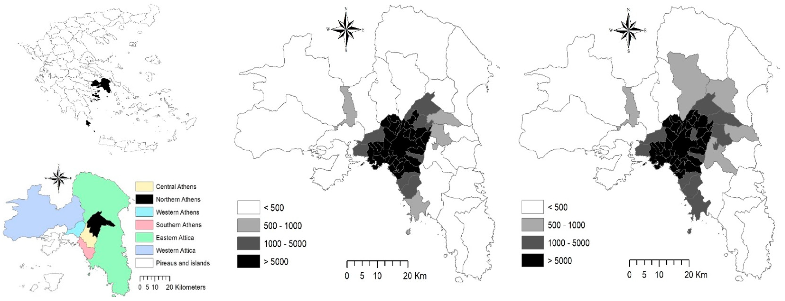
2.1. Study Area

The investigated area coincides with the geographical region of Attica, Central Greece (nearly 3800 km2), corresponding with the NUTS-2 level of the European Nomenclature of Territorial Statistical Units. Occupying a strategic position in the middle of the Aegean Sea, the area has an undulated terrain that alternates between coastal and inland plains (the largest is the ‘Lekanopedio Attikis’, hosting Athens) and mountain ranges (Parnitha, Pendeli, Imitos) frequently exceeding 1000 m of elevation. Attica is administered by 8 regional units (‘Periferiaki Enotites’) according to the ‘Kallikratis’ reform of local authorities (central, western, northern, and southern Athens, western and eastern Attica, Piraeus, and the surrounding islands in the Argosaronic Gulf), that reflect the most recent structure of regional administration in force over a large part of the study period (Figure 1). Most of the local authorities (n = 59), corresponding with the municipal level of governance [63], gravitated toward metropolitan Athens, as delineated in the Urban Atlas initiative of the European Environment Agency [54]. The area (encompassing mainland Attica and the neighboring island of Salamina, few kilometers far from the sea coast of Piraeus and Perama) displays an economic base integrating traditional and advanced services with public administration [64], although manufacturing, tourism, and construction industries were (and still are) important sectors for local development [23,65,66].
Similarly to other Mediterranean cities (Barcelona, Naples, Palermo, Thessaloniki and, in part, Rome, Istanbul, and Valencia), Athens’ expansion was basically radio-centric, shifting to moderate settlement dispersion in recent decades [45]. In the 1950s and the 1960s, metropolitan regions in Greece—and mostly Athens—attracted intense immigration flows from rural districts [67]. While internal migration fueled urban expansion in the 1970s [68], migration flows in the 1980s were directed mostly to peri-urban areas ([13]), leading to stagnant population growth in core cities [69]. Following a relatively short wave of economic expansion encompassing the late 1990s and the early 2000s, Greece has undergone a political and social crisis since 2007 [70], with rising unemployment and urban poverty, austerity urbanism, reduced public spending, and consequent cuts in primary services [54].

2.2. Official Statistics
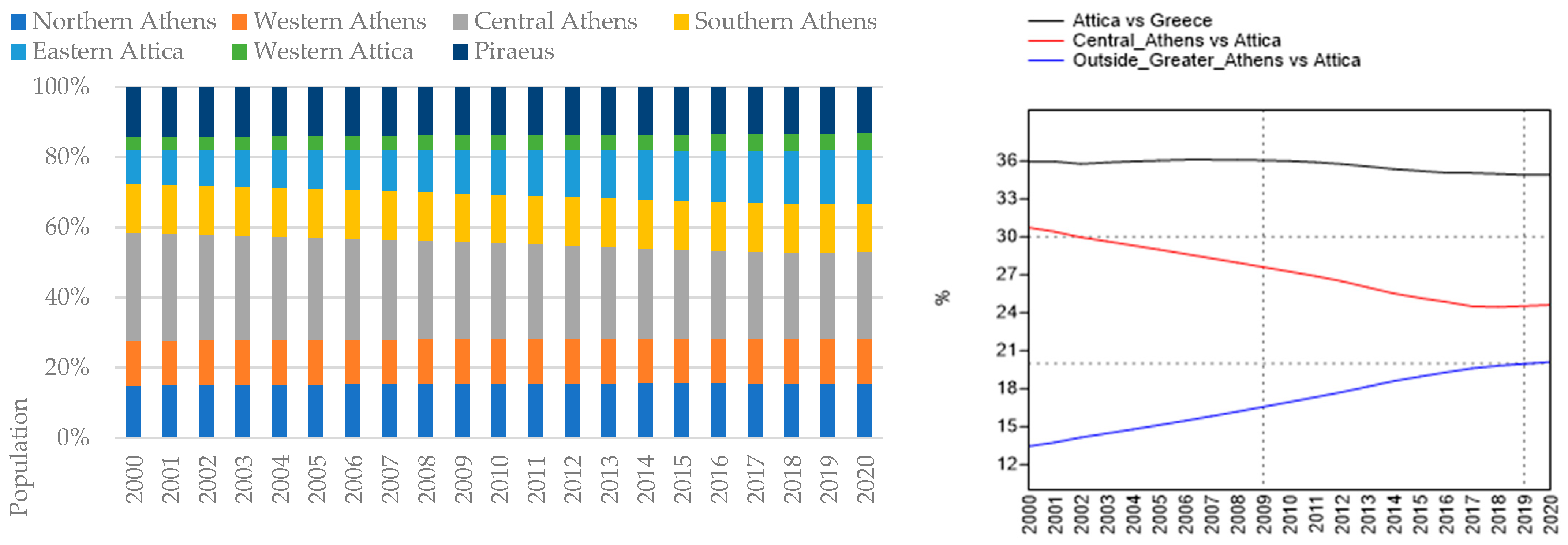
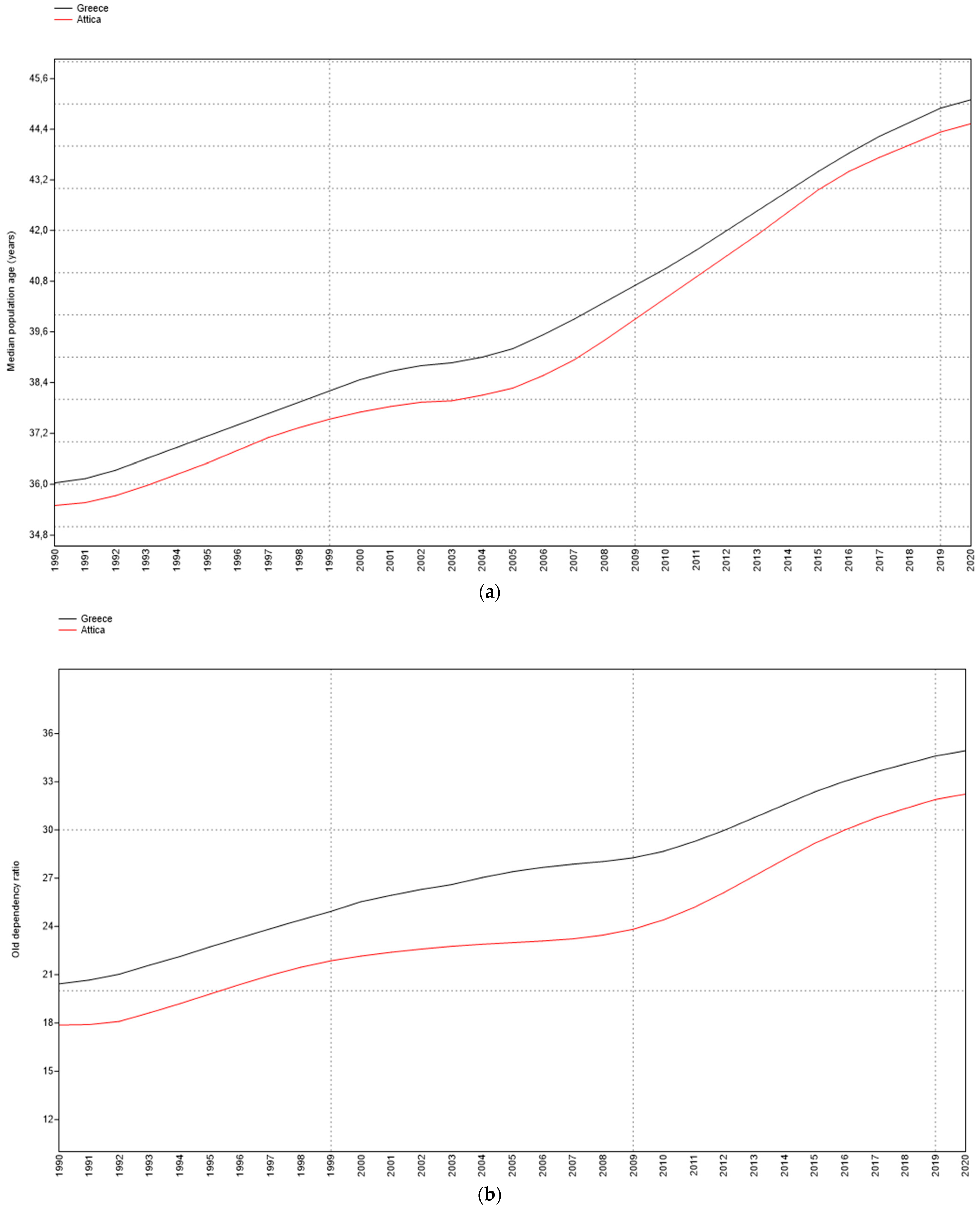
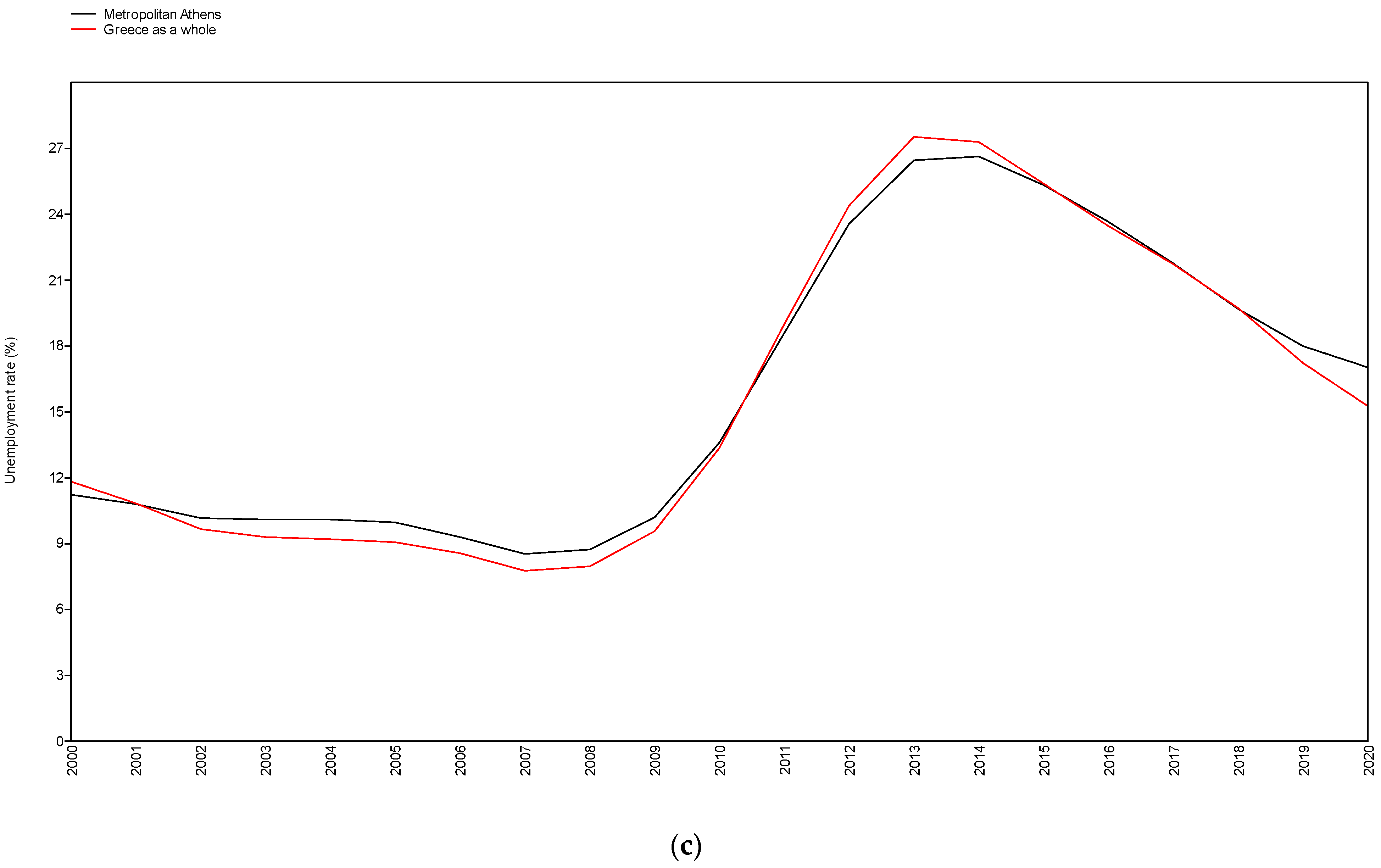
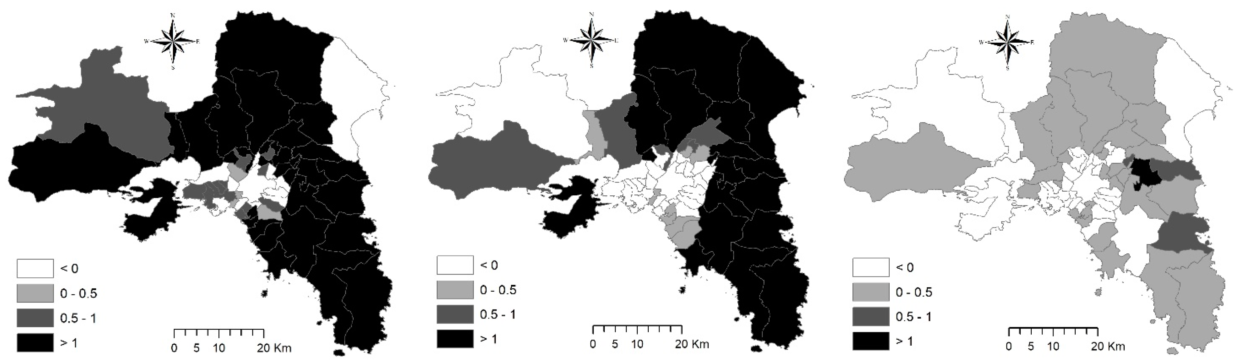
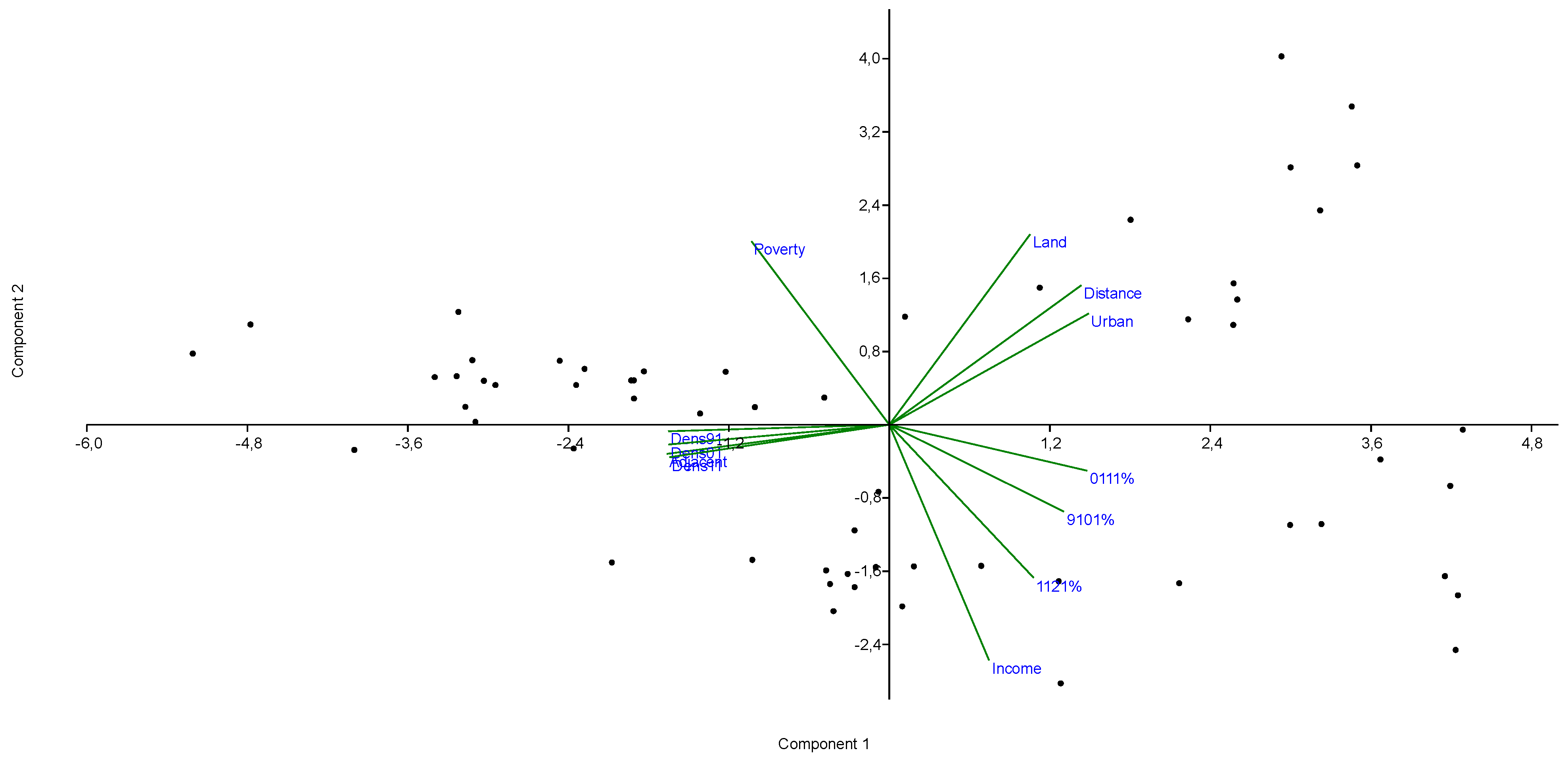
We elaborated on official statistics from multiple sources (Table 2) with the aim at providing a refined analysis of demographic and urban dynamics in Attica [14]. The use of statistical data from multiple sources brings with it some limitations and difficulties of standardization because of heterogeneous time series and divergent spatial definitions [41,45,66]. Population trends were investigated considering the municipal results of the General Censuses of Population and Household held in Greece (1991, 2001, 2011, 2021) by the National Statistical Service (ESYE, now ELSTAT) and short-term data (2000–2020) from population registers by regional unit (NUTS-3 level) released annually by the Greek Statistical Authority (ELSTAT). Population density and selected indicators of population age structure (2014 and 2020) were derived from population censuses (the former aggregate) and from the annual estimation of resident population (the latter aggregate) based on the aggregate information collected in the national demographic register at the same spatial scale [64]. The unemployment rate was finally derived from OECD regional statistics updating and reorganized regional time series originally collected in the Labor Force Survey carried out annually (ELSTAT) on a regional basis in Greece.
Statistical analysis of population growth (annual percent rates by decade: 1991–2001, 2001–2011, 2011–2021) made use of descriptive techniques and visualization of the spatial distribution of relevant variables through mapping. Population growth rates were also correlated pair-wise with a number of independent variables, including (i) population density (inhabitants/km2) at the beginning of each study decade (i.e., 1991, 2001, 2011, labelled as ‘Dens’); (ii) urban condition (a proxy delineating municipalities that belong to the Greater Athens’ area (‘1’) as opposed to municipalities located in the surrounding (peri-urban and rural) territories); (iii) distance from downtown Athens (km); (iv) per-capita income (Euros) from fiscal declarations; (v) a composite index of Poverty sensu Townsend (mixing personal income data with housing variables derived from population and household census); and (vi) municipal surface area (km2), a proxy controlling for the importance of administrative size [23]. Parametric (Pearson) and non-parametric (Spearman and Kendall) coefficients were used in this analysis testing for significance (against H0: no correlation) at p < 0.05 or p < 0.001 after Bonferroni’s correction for multiple comparisons [47]. A principal component analysis (PCA) was finally run on the complete data matrix (including all the variables described above. The analysis decomposed the basic signals of population growth in few independent components associated with specific predictors assumed as relevant (direct or indirect) drivers of urban expansion [3].

3. Results

Based on national censuses, the population followed an inverse U-shape trend in the study area between 1991 and 2021. The total population increased between 1991 and 2001 (moving from 3,562,233 inhabitants to 3,858,454 inhabitants) and then decreased slightly in 2011 (3,793,066 inhabitants) and 2021 (3,759,669 inhabitants). Downtown Athens’ population (comprising the core city) declined more rapidly (a total of 816,556 inhabitants in 1991; 789,166 inhabitants in 2001; 664,046 inhabitants in 2011; and 637,798 inhabitants in 2021) and accounted for a decreasing share in the total population (from 23% in 1991 to 17% in 2021). Considering continuous (annual) data from demographic registers at the prefectural level (NUTS-3), the percent share of district population in total population (study area) transformed slightly during the last 20 years, evidencing how the whole metropolitan region loses population in the last decade after a decade of substantial stability (or weak decline). The (annual) percent rate of change over time in the share of district population in the total Greek population was also calculated and is illustrated in Figure 2.
The percent share of Attica in the total Greek population was relatively constant in the 2000s (from 35.9% in 2000 to 36.1% in 2010), and decreased in the following decade (34.9% in 2020). The share of central Athens’ district in Attica’s population has, in turn, reduced from 30.7% in 2000 to 24.5% in 2017, before a slight recovery (24.6% in 2020). A stable population in the 2000s and a moderate decline in the 2010s was also observed in the Piraeus’ regional unit, which represents a significant part of the urban area. Different dynamics have been observed in the regional units forming the Greater Athens’ area. In northern Athens, the population increased and decreased with the same intensity, respectively, in the first and second decades. Similar dynamics were observed in western Athens, with a peak recorded in 2010. In southern Athens, the population grew slowly until 2008, with a more marked decline starting in 2009. The demographic weight of the areas outside the Greater Athens’ conurbation (i.e., the regional units of eastern Attica and western Attica) has undergone a slow but continuous increase (from 13.5% in 2000 to 20.1% in 2020). These data highlight heterogeneous population dynamics. Compared with the relative stability of Attica’s primacy in Greece, a more intense demographic shrinkage was observed in the Greater Athens’ area, with early signs of recovery since 2018 in central Athens. Piraeus, an industrial district in rapid conversion toward residence, commerce, and tourism since the 1950s, experienced a modest population reduction, following a much more intense decline in the earlier decades.
Socio-demographic dynamics in the study area were summarized with the contribution of distinctive indicators: mean population age and old dependency index showed a continuous increase over time between 1990 and 2020, delineating demographic aging—recognized as one of the most relevant (contextual) factors at the base of metropolitan shrinkage (Figure 3). Regional dynamics in Attica finely resembled those observed for Greece as a whole. More specifically, Attica resulted as a region with a younger age profile than the country as a whole. However, regional differences reduced substantially over the study period. The unemployment rate showed in turn a particularly definite dynamics separating economic expansion (up to 2008) and recession (2008 onwards). Average unemployment rates in these periods were, respectively, 9% and 21%, with slight differences between Attica and Greece as a whole. A rising unemployment rate was a powerful signal of the reduced economic attractiveness, possibly leading to long-term demographic decline because of persistent job shortages and urban poverty, at least for some categories of workers (e.g., working poor). Taken together, population aging and unemployment are considered as candidate factors at the base of urban shrinkage in contemporary Athens and displayed particularly intense effects in the most recent decade.
A more complete outlook of demographic dynamics in the study area was provided, moving toward the local scale and producing a detailed analysis of the annual rate of population change (%) derived from the national censuses of households (Figure 4). The spatial distribution of the annual population growth rate highlights important changes in the socioeconomic context characteristic of metropolitan Athens. In the first decade (1991–2001), a polarized population growth between urban and rural areas was observed, with a demographic decline evident in the former and a very intense growth observed in the latter. This spatial pattern was further consolidated in the following decade (2001–2011), with a thorough expansion of demographic declining dynamics in central areas and a moderate stability of the growing areas at the fringe of compact settlements. On the contrary, the subsequent period (2011–2021) showed a drastic spatial change, with population growth concentrated in the municipalities east of Athens and a decline that radiates from central to peripheral areas west of the capital city. Based on earlier studies, this work assumes the east–west gradient in the metropolitan area of Athens as an axis of wealth-poverty which is, among other things, rather stable on both urban (Greater Athens) and metropolitan (Attica) scales.
A more complete graphical representation of local population dynamics in the study area is provided in Figure 5, classifying municipalities (distinguished with an official, four-digit label in use at ELSTAT and assigned uniquely to each administrative entity) on the basis of demographic growth rates (positive or negative) at two sequential decades, comparing pair-wise the 1991–2001 with the 2001–2011 data series (panel ‘a’), and the 2001–2011 with the 2011–2021 data series (panel ‘b’). The spatial distribution of municipalities within metropolitan Athens (e.g., the specific location of each administrative entity along the center-periphery gradient) can be evaluated considering the first two digits of the municipal code associated with each dot in the scatterplot. These two digits are uniquely associated with a Greek prefecture, as illustrated in Figure 1 (lower left); the first two digits from ‘45’ to ‘52’ correspond to prefectures (NUTS-3 level of the European classification of Territorial Statistical Units) belonging to the administrative region of Attica (NUTS-2 level). More specifically, ‘45’ corresponds with central Athens’ prefecture, ‘46’ with northern Athens’ prefecture, ‘47’ with western Athens’ prefecture, ‘48’ with southern Athens’ prefecture, ‘49’ with eastern Attica’s prefecture, ‘50’ with western Attica’s prefecture, ‘51’ with Piraeus’ prefecture and, finally, ‘52’ with the islands of the Argosaronic Gulf of the Aegean Sea belonging to a unique prefecture gravitating on Piraeus node. Prefectures ‘45’, ‘46’, ‘47’, ’48’, and ‘51’ included municipalities belonging to the Greater Athens’ conurbation, a compact, dense, and spatially continuous settlement area most tightly gravitating toward Athens’ and Piraeus’ urban nodes. Prefectures ‘49’, ‘50’, and ‘52’ include municipalities outside the Greater Athens’ area and thus are considered peripheral as far as their geographical location is concerned.
Based on the results of this analysis, municipalities were classified within one of the four quadrants of the scatterplot, indicating, respectively, positive–positive (quadrant I), negative–positive (quadrant II), negative–negative (quadrant III), and positive–negative population dynamics over time. The number of municipalities with fully declining populations (quadrant III), mainly located in central districts (namely prefectures coded ‘45’, ‘46’, ‘47’, or ‘51’, see above), increased between the first observation time (1991–2011) and the second one (2001–2021). The same dynamics were recorded for municipalities with population recovery after a long decline (quadrant II, comparing the first with the second observation time). Quadrant I includes municipalities in peripheral locations within the Greater Athens’ conurbation and, even more frequently, municipalities from rural places in Attica (prefectures with codes ‘49’, ‘50’, or ‘52’). In both observation times, a positive—and basically linear—relationship between population growth rates at the municipal scale, in both the first and the second decade, was observed (1991–2001 vs. 2001–2011: Pearson linear moment-product correlation coefficient: r = 0.68; Spearman non-parametric rank correlation coefficient: rs = 0.79; both n = 59, p < 0.001). However, the intensity of this relationship declined substantially in the second observation time, indicating a high spatial heterogeneity in population dynamics especially in the last decade, in line with earlier results (2001–2011 vs. 2011–2021: Pearson linear moment-product correlation coefficient: r = 0.58; Spearman non-parametric rank correlation coefficient: rs = 0.51; both n = 59, p < 0.01).
Starting from this preliminary analysis, we profiled municipalities on the basis of positive or negative growth rates by decade, as reported in Table 3. We delineated six classes of municipalities with distinctive population dynamics (e.g., the ‘−/−/−’ label indicates a municipality experiencing a continuous population decline over the three investigated decades; the ‘+/−/−’ label instead defines a municipality with population increase in 1991–2001 that underwent a subsequent demographic decline in both 2001–2011 and 2011–2021). The two extreme municipal classes (continuous population increase and continuous population decline) accounted for the majority of population residing in metropolitan Athens (nearly 60% in both 1991 and 2021). Municipalities with permanent demographic decline—mainly located in central districts—lost nearly 10% of their resident population in metropolitan Athens (passing from 41% in 1991 to 32% in 2021).
Conversely, municipalities with permanent demographic expansion—mainly located in peripheral districts—acquired nearly 10% of their resident population (passing from 19% in 1991 to 28% in 2021). A sequence of positive and negative expansion stages (i.e., ‘+/−/−’ or ‘+/+/−’) reflecting an incipient decline after growth (possibly associated with late suburbanization and early counter-urbanization) was observed in municipalities of the Greater Athens’ basin with (mostly) stable population. A sequence of negative and positive expansion stages (i.e., ‘−/−/+’), reflecting population recovery after a (more or less) long decline, was an infrequent trend involving municipalities that concentrated around 2% of the total population in metropolitan Athens. These municipalities—heterogeneously located across the study area—may represent local communities showing signals for early re-urbanization that should be confirmed along a broader time interval. Finally, a relatively heterogeneous profile (i.e., ‘+/−/+’) delineating more complex demographic dynamics, included both urban and suburban municipalities that concentrated nearly 6–7% of the total population in metropolitan Athens, being rather stable over time.
Results of correlation analysis (Figure 4) and municipal profiling (see Table 3) document the relative stability of the spatial distribution of population growth (and the related socioeconomic impulse) in the long-term development path of metropolitan Athens. An additional investigation based on (parametric and non-parametric) correlation statistics provides a broader interpretation of the influence socioeconomic/territorial contexts and local background conditions have on population growth rates (Table 4). Correlation patterns were rather distinctive when comparing results for 1991–2001 and for 2001–2011 with those for 2011–2021. In both decades (1991–2001 and 2001–2011), population growth rates were higher in the Greater Athens’ area than in the rest of Attica, but the same rate was negatively associated with urban concentration (there were similar results for the percent rate of adjacent buildings—indicating the dominance of compact settlements—and population density).
Interestingly, the distance from downtown Athens—especially during the 1990s—was less positively correlated with population growth rates than other variables of economic agglomeration. Modest differences were found between parametric and non-parametric correlation coefficients, suggesting the existence of linear or quasi-linear relationships between the relevant variables under investigation. On the contrary, per-capita income and the poverty index were less intensively correlated (respectively, with positive and negative coefficient sign) with population growth rates in both decades. Taken as a control variable, municipal area was uncorrelated (or weakly correlated) with population growth rates. All in all, these results indicate a mechanism of urban expansion mostly oriented toward agglomeration economies and suburbanization stimuli. The highest growth rates were observed in semi-urban or suburban contexts within the consolidated urban agglomeration (Greater Athens), but not in central municipalities surrounding the inner city. In line with earlier evidence, the geography of population growth changed in the most recent decade (2011–2021) since pair-wise correlations with per-capita income and the poverty index were more intense than the correlations with variables indicating agglomeration forces (distance from downtown Athens, compact settlements, population density, and urban municipalities).
A principal component analysis (PCA) was finally developed to confirm the results obtained from the bivariate statistical analysis presented above. The analysis extracted two basic components that explain, respectively, 58.3% and 19.3% of the overall variance deriving from 11 input variables. The biplot representing the position of both variables (loadings, blue labels) and cases (municipalities, black dots) in the scatterplot projecting principal components one and two is illustrated in Figure 6. The extracted axes decomposed Athens’ expansion into widely differentiated processes. Population growth rates (at all investigated time intervals: 1991–2001 (‘9101%’), 2001–2011 (‘0111%’), and 2011–2021 (‘1121%’)) were associated with quadrant II. In particular, population growth in the last decade (2011–2021) was moderately associated with the spatial distribution of per-capita income (‘Income’) as opposed to the Townsend poverty index (‘Poverty’). The rate of population growth in the previous two decades (1991–2001 and 2001–2011) was opposed to the level of population density—a variable oriented toward the negative values of Axis 1 (‘Dens91’, ‘Dens01’, ‘Dens11’)—and settlement compactness (‘Adjacent’). The distance from the inner city (‘Distance’), municipal surface area (‘Land’), and the urban dimension (i.e., municipalities belonging to the Greater Athens’ area, labelled with ‘Urban’) were clustered within Quadrant I, highlighting a dimension of growth weakly associated with population dynamics—especially with the most recent ones—and thus confirming the results of bivariate correlations.

4. Discussion

Recent metropolitan dynamics require a holistic governance managing the intrinsic relationship between location factors, land-use, spatial planning, and socio-demographic trends [63,71,72]. As a result of economic change, demographic dynamics have had an influential effect on the evolution of inner cities, suburbs and rural areas, de-concentrating, re-densifying and, in some ways, diversifying those districts e.g., [60,73,74]. Giving value to all the possible official statistics available from the public authorities of Greece and, more generally, the European Union (e.g., Eurostat), our study demonstrates that a refined integration of statistical data from multiple information sources may provide an enhanced description of a given phenomenon, in this case urban change, metropolitan growth, and the related demographic trends vis à vis socioeconomic transformations. While committed to a multivariate exploratory data analysis—without searching for a direct causality between demography and economic aspects—this approach is, to our knowledge, one of the first in the current literature trying to document urban growth and decline via demographic changes and the possible association with the background socioeconomic context (e.g., wealth and income/poverty conditions) before, during and after the great crisis, considering broader dynamics encompassing the last three decades.
A comprehensive scrutiny of official statistics indicates that population growth in metropolitan Athens has been observed for centuries (the first comparable observation available is for 1848) in three geographical partitions (downtown Athens, Greater Athens’ area, Attica region), evidencing an extraordinary stability in long-term population trends [22], and in turn delineating shorter cycles of demographic accelerations and decelerations [75]. Population growth was particularly intense after World War I, and the highest population density in downtown Athens (more than 15,000 inhabitants/km2) was recorded relatively late in the city history, i.e., in the early 1970s [68,69,70]. In the following decade, suburbanization has leveraged the expansion of sparse settlements along the coastal rim and in accessible flat districts at considerable distances from Athens [76]. Rural areas with sparse settlements, especially in the Thriasio (western Attica), Messoghia (eastern Attica), and oropos (Northern Attica) districts, showed traditional landscapes and settlements undergoing intense socioeconomic transformations in recent decades [66]. After uninterrupted expansion [77], the total population started declining—for the first time in recent history—in the 1980s (downtown Athens), in the 2000s (Greater Athens’ area), and in the 2010s (Attica). In the last half century, population density in Attica expanded from less than 500 inhabitants/km2 (1951) to more than 1000 inhabitants/km2 (2021), broadening the divide in Greater Athens and the surrounding (non-urban) districts [78]. Empirical results of independent studies confirm how, for the first time in the contemporary history of Athens [14], several indicators of urban growth assumed negative values at all geographical partitions in the last decade (2011–2021), delineating a process of urban decline [54].
These findings plastically document the intrinsic evolution of Athens toward a spatially segregated development path at the local scale associated with a generalized demographic decline at the regional scale [67,79,80]. Irrespective of their location within the metropolitan region, affluent municipalities—both in urban contexts and in suburban/rural areas—attracted populations and consolidated a long-term settlement growth [81,82,83]. Economically disadvantaged municipalities have lost population (e.g., moving toward affluent communities or outside the study area), as a result of a continuous decline in quality of life [13], a reduced economic attractiveness [74], increased poverty [45], severe material deprivation conditions [66], and a generalized degradation of settlements (territory, environment, infrastructure, education, and job opportunities). Spatially variegated patterns of metropolitan shrinkage—consolidating rapidly in the study area—should be investigated further in a comparative perspective, e.g., in other cities of Mediterranean Europe and, for generalization, in other European urban agglomerations [84], evidencing the peculiarity or the increasing diffusion of local processes of demographic shrinkage in a broader context of economic decline [85,86,87]. Likely for the first time in southern Europe, the recent socio-demographic patterns observed in Athens may document a spatially segregated population growth based on a richness–poverty gradient [88]. Local communities increasingly compete for attracting populations [89]. In this perspective, wealthier communities were assumed to provide high-quality services and a satisfactory economic environment, possibly attracting continuous population flows [65]. Such trends have progressively replaced the most traditional patterns of settlement and population expansion based on accessibility, agglomeration, and scale economies—rarely coinciding with the mechanisms of wealth accumulation at the local scale [63].
By providing an informative base for urban studies in shrinking cities, our work stimulates the implementation of more effective policies that strengthen local competitiveness and sustainability, being applicable to similar socioeconomic and territorial contexts [23]. If regulating long-term demographic dynamics (e.g., population aging, fertility decline) is particularly difficult from a purely local perspective [90], unemployment reduction and the containment of poverty gaps appear as indispensable policy targets on a regional scale [91], together with a more coordinated development strategy for inner cities [92]. Early, although weak, signs of a demographic recovery in Athens, as in other Mediterranean cities, testify how ‘crisis-driven’ shrinkage processes can be managed through multi-target and multi-scalar policies [93]. These policies should valorize the implicit advantages of the new (post-crisis) socioeconomic context, e.g., exploiting opportunities derived from the collapse of land and house prices [20].
From a technical perspective, our work documents the importance of demographic and socioeconomic indicators in the analysis of urban shrinkage, with reference to both local dynamics and latent trends on a regional and national scale [3]. From this perspective, indicators that can be disaggregated at particularly fine territorial levels and are available along a sufficiently long and representative historical series encompassing an entire urban cycle are particularly appreciated [94]. Moreover, the practical availability of these aggregates should be increased, even in advanced countries with a long tradition of official statistics [4]. In many cases, even today, population censuses represent the only reliable source, updated every 10 years, when describing latent socio-demographic dynamics at a municipal (or district) scale [47]. A ten-year updating period (typical of (traditional) census waves—at least in Europe), however, does not seem to be completely compatible with the research needs for specific economic and social phenomena that are articulated in space over a medium-short time span (e.g., [95]), thus requiring administrative information sources, potentially updated on annual scales but possibly biased because of systematic and non-systematic factors that are not completely controlled—as in a formal census or sampling survey of a national statistical system.
The case study analyzed in our work exemplifies such context and provides some relevant insight to official statistics. Spatially explicit analysis in this study was restricted to the use of data and indicators uniquely derived from population censuses. In Greece, population censuses run every 10 years, making it hard to decompose inter-census trends (e.g., delineating short-term tendencies in specific years—or couples of years—in the studied decade) without additional, non-census, data sources [96]. In the case of Greece, inter-census data sources, namely population registers or population sampling surveys, are partial, or released at a very aggregated spatial level, especially as far as total population and population dynamics are concerned. More specifically, municipal data, which is the spatial unit of interest in our study, were released only in correspondence with decadal population censuses. So, based on this timing, the use of census data, the most relevant data source for the country and the most accurate for spatial analysis, forced us to consider decadal periods that went between 1991 and 2001, between 2001 and 2011, and between 2011 and 2021. When possible, we also used other data sources released annually at prefectural (NUTS-3) or regional (NUTS-2) levels, and which are not decomposable further toward lower geographical levels [97]. Based on this timing, we were forced to consider, in the last census decade (2011–2021), some effects of the COVID-19 pandemic in metropolitan Athens’ population and urban dynamics.
Since this paper operationalizes urban growth through total population growth—that aggregates together the individual trends in fertility, mortality, and (internal/international) migration—preliminary evidence suggests how the COVID-19 pandemic has strongly impacted short-term demographic trends [98], but the aggregate effect over longer times could be not more intense than the impact of the great economic crisis ten years before. Compared with economic dynamics, demographic dynamics displayed a sort of intrinsic stability that characterized their long-term trend, even with important, short-term perturbations [96]. In our case, when pandemics can exert a strong negative impact on mortality rates in the short-term, fertility rates may experience a less evident (and delayed) decrease than the increase in mortality rates. In both cases, these impacts can be (more or less) temporary. Some very recent statistics in Europe demonstrate the recovery in fertility rates in 2021, and especially in 2022. The pandemic’s impact on total population growth was demonstrated to go in exactly the same direction as the indirect impacts exerted by the 2007 crisis [99]; this is especially evident in urban areas. In other words, this means that total population may progressively reduce in metropolitan regions because of a progressive shrinkage indirectly driven by the 2007 crisis first and the 2020 pandemic later on. So, it is particularly urgent to jointly consider the impact of both perturbations in order to have a stronger idea of the future demographic trends in urban areas [97]. In other words, taking account of the last data releases, urban demographic trends, moving toward an increased ‘shrinkage’ and spatial heterogeneity because of the 2007 crisis were reinforced by the COVID-19 pandemic. Arguments such as the persistence of the COVID-19 pandemic’s impacts, and the final outcomes of both crises in population growth rates, clearly deserve further investigation and analysis, when more data and longer time series will be released [98]. From this perspective, integrating census data at a very disaggregate spatial scale with annual data from registers and surveys released on more aggregate spatial units provides the necessary clarification of latent demographic processes consolidated in recent years (e.g., [99]). This allows isolating the impact of the pandemic years on demographic trends from the long-term background trends due to economic downturns.
A final issue of this study that merits an explicit comment is the use of aggregate population definition (namely, total population) as a proxy of urban growth or decline instead of a deeper analysis of the individual components of the population balance, namely natural population growth (i.e., the difference between birth rates and death rates) and migration rates. This choice is motivated with the fact that we are interested in a regional demography analysis with outcomes of interest for urban studies and regional studies. Total population growth rates are widely investigated in this perspective, and they constitute, e.g., the topical knowledge for the comprehensive theory of city life cycle, interpreting the metropolitan cycle on the basis of total demographic dynamics [14,28,87]. As clarified above, the only available source of information in Greece is the demographic census with decadal releases for the study of total population dynamics at a quite disaggregated spatial scale (i.e., municipalities). For 2021, population census data were released in a very partial way, because census operations were still on-going. Despite the intrinsic data limitations, decomposing total population growth in natural balance and migratory components can provide an enriched description of urban dynamics. However, the decomposition of total population growth in natural balance and migration components is rather difficult from traditional censuses, and it is better clarified using data from population registers, that for Greece are available at a rather aggregate spatial and conceptual level. The outcomes of this study, and the relevance of the issue at stake, justify a strong technical effort improving official statistics in the country, with a better data integration and information matching among censuses, administrative registers, and public sampling surveys sources.

5. Conclusions

Our study documents how a conceptual integration of multiple data sources contributed to overcome (or, at least, reduce) the limitation of individual statistical sources, providing a more comprehensive framework for analysis of complex and latent phenomena, such as urban dynamics (growth and shrinkage) based on population trends. Far from having exclusively negative impacts on economic performances and social trends, recent demographic dynamics seem to have more complex implications for metropolitan transformations at large [100], possibly representing a natural process of urban de-concentration in hyper-compact contexts [55,86,101]. This process, although intrinsic to urban shrinkage, gives some unexpected opportunities for sustainable, integrated, and spatially balanced post-crisis development [56]. For instance, how much the actual pandemic crisis can affect urban shrinkage in post-crisis Mediterranean contexts is a subject of extensive debate [102]. Moreover, opportunities for urban–rural re-balance inherent in a more intense phase of (smart-working driven) counter-urbanization (e.g., [103]), may stimulate coordinated actions fueling spatial cohesion, fighting poverty, and containing the unwanted consequences of social segregation [104]. Measures promoting local development and city planning could benefit from a tight integration with policies containing urban poverty and orienting spatial transformations toward social cohesion [105]. This framework finally allows an honest interpretation of complex processes of metropolitan shrinkage [106], proposing realistic solutions to a finely tuned city growth with present (and future) population dynamics.

Author Contributions

Conceptualization, L.S. and K.R.; methodology, L.S.; software, K.R.; validation, E.M.M. and M.G.; formal analysis, L.S.; investigation, K.R.; resources, M.G.; data curation, M.G.; writing—original draft preparation, L.S. and K.R.; writing—review and editing, S.M. and M.G.; visualization, M.G. and S.M.; supervision, E.M.M. and S.M.; project administration, E.M.M. All authors have read and agreed to the published version of the manuscript.

Funding

This research received no external funding.

Institutional Review Board Statement

Not applicable.

Informed Consent Statement

Not applicable.

Data Availability Statement

Not applicable.

Conflicts of Interest

The authors declare no conflict of interest.

References

  1. Arribas-Bel, D.; Nijkamp, P.; Scholten, H. Multidimensional urban sprawl in Europe: A self-organizing map approach. Comput. Environ. Urban Syst. 2011, 35, 263–275. [Google Scholar] [CrossRef] [Green Version]
  2. Aurambout, J.P.; Barranco, R.; Lavalle, C. Towards a simpler characterization of urban sprawl across urban areas in Europe. Land 2018, 7, 33. [Google Scholar] [CrossRef] [Green Version]
  3. Ciommi, M.; Chelli, F.M.; Carlucci, M.; Salvati, L. Urban growth and demographic dynamics in southern Europe: Toward a new statistical approach to regional science. Sustainability 2018, 10, 2765. [Google Scholar] [CrossRef] [Green Version]
  4. Carlucci, M.; Chelli, F.M.; Salvati, L. Toward a new cycle: Short-term population dynamics, gentrification, and re-urbanization of Milan (Italy). Sustainability 2018, 10, 3014. [Google Scholar] [CrossRef] [Green Version]
  5. Haase, A.; Kabisch, S.; Steinführer, A.; Bouzarovski, S.; Hall, R.; Ogden, P. Spaces of reurbanisation: Exploring the demographic dimension of inner-city residential change in a European setting. Popul. Space Place 2010, 16, 443–463. [Google Scholar] [CrossRef]
  6. Kroll, F.; Kabisch, N. The Relation of Diverging Urban Growth Processes and Demographic Change along an Urban-Rural Gradient. Popul. Space Place 2012, 18, 260–276. [Google Scholar] [CrossRef]
  7. Lauf, S.; Haase, D.; Seppelt, R.; Schwarz, N. Simulating demography and housing demand in an urban region under scenarios of growth and shrinkage. Environ. Plan. B Plan. Des. 2012, 39, 229–246. [Google Scholar] [CrossRef]
  8. Gil-Alonso, F.; Bayona-i-Carrasco, J.; Pujadas-i-Rúbies, I. From boom to crash: Spanish urban areas in a decade of change (2001–2011). Eur. Urban Reg. Stud. 2016, 23, 198–216. [Google Scholar] [CrossRef]
  9. Duvernoy, I.; Zambon, I.; Sateriano, A.; Salvati, L. Pictures from the other side of the fringe: Urban growth and peri-urban agriculture in a post-industrial city (Toulouse, France). J. Rural. Stud. 2018, 57, 25–35. [Google Scholar] [CrossRef]
  10. Lerch, M. Internal and international migration across the urban hierarchy in Albania. Popul. Res. Policy Rev. 2016, 35, 851–876. [Google Scholar] [CrossRef] [Green Version]
  11. Liu, L. Fertility trends in China’s more developed urban districts: The case of four cities. Popul. Space Place 2005, 11, 411–424. [Google Scholar] [CrossRef]
  12. Longhi, C.; Musolesi, A. European cities in the process of economic integration: Towards structural convergence. Ann. Reg. Sci. 2007, 41, 333–351. [Google Scholar] [CrossRef]
  13. Arapoglou, V.P.; Sayas, J. New facets of urban segregation in southern Europe—Gender, migration and social class change in Athens. Eur. Urban Reg. Stud. 2009, 16, 345–362. [Google Scholar] [CrossRef]
  14. Morelli, V.G.; Rontos, K.; Salvati, L. Between suburbanisation and re-urbanisation: Revisiting the urban life cycle in a Mediterranean compact city. Urban Res. Pract. 2014, 7, 74–88. [Google Scholar] [CrossRef]
  15. Ogden, P.E.; Hall, R. Households, reurbanisation and the rise of living alone in the principal French cities 1975–1990. Urban Stud. 2000, 37, 367–390. [Google Scholar] [CrossRef]
  16. Nijkamp, P.; Kourtit, K. The “new urban Europe”: Global challenges and local responses in the urban century. Eur. Plan. Stud. 2013, 21, 291–315. [Google Scholar] [CrossRef]
  17. Oueslati, W.; Alvanides, S.; Garrod, G. Determinants of urban sprawl in European cities. Urban Stud. 2015, 52, 1594–1614. [Google Scholar] [CrossRef] [PubMed] [Green Version]
  18. Repetti, M.; Phillison, C.; Calasanti, T. Retirement Migration in Europe: A Choice for a Better Life? Sociol. Res. Online 2008, 23, 780–794. [Google Scholar] [CrossRef]
  19. Salvati, L. The Dark Side of the Crisis: Disparities in per Capita income (2000–12) and the Urban-Rural Gradient in Greece. Tijdschr. Voor Econ. En Soc. Geogr. 2016, 107, 628–641. [Google Scholar] [CrossRef]
  20. Robinson, J. Cities in a world of cities: The comparative gesture. Int. J. Urban Reg. Res. 2017, 35, 1–23. [Google Scholar] [CrossRef]
  21. Lerch, M. The role of migration in the urban transition: A demonstration from Albania. Demography 2014, 51, 1527–1550. [Google Scholar] [CrossRef] [PubMed] [Green Version]
  22. Salvati, L.; Sateriano, A.; Grigoriadis, E. Crisis and the city: Profiling urban growth under economic expansion and stagnation. Lett. Spat. Resour. Sci. 2016, 9, 329–342. [Google Scholar] [CrossRef]
  23. Rontos, K.; Grigoriadis, E.; Sateriano, A.; Syrmali, M.; Vavouras, I.; Salvati, L. Lost in protest, found in segregation: Divided cities in the light of the 2015 “Oχι” referendum in Greece. City Cult. Soc. 2016, 7, 139–148. [Google Scholar] [CrossRef]
  24. Stockdale, A. Contemporary and ‘Messy’ Rural In-migration Processes: Comparing Counterurban and Lateral Rural Migration. Popul. Space Place 2016, 22, 599–616. [Google Scholar] [CrossRef] [Green Version]
  25. Stergiou, D.P.; Papatheodorou, A.; Tsartas, P. Second home conversion during the economic crisis: The case of Artemida, Greece. Soc. Cult. Geogr. 2017, 18, 1129–1151. [Google Scholar] [CrossRef]
  26. Bontje, M. Facing the challenge of shrinking cities in East Germany: The case of Leipzig. GeoJournal 2005, 61, 13–21. [Google Scholar] [CrossRef]
  27. Couch, C.; Karecha, J.; Nuissl, H.; Rink, D. Decline and sprawl: An evolving type of urban development – observed in Liverpool and Leipzig. Eur. Plan. Stud. 2007, 13, 117–136. [Google Scholar] [CrossRef]
  28. Turok, I.; Mykhnenko, V. The trajectories of European cities, 1960-2005. Cities 2007, 24, 165–182. [Google Scholar] [CrossRef]
  29. Dijkstra, L.; Garcilazo, E.; McCann, P. The effects of the global financial crisis on European regions and cities. J. Econ. Geogr. 2015, 15, 935–949. [Google Scholar] [CrossRef]
  30. Martinez-Fernandez, C.; Audirac, I.; Fol, S.; Cunningham-Sabot, E. Shrinking cities: Urban challenges of globalization. Int. J. Urban Reg. Res. 2012, 36, 213–225. [Google Scholar] [CrossRef]
  31. Mallach, A.; Haase, A.; Hattori, K. The shrinking city in comparative perspective: Contrasting dynamics and responses to urban shrinkage. Cities 2017, 69, 102–108. [Google Scholar] [CrossRef]
  32. Nelle, A.; Großmann, K.; Haase, D.; Kabisch, S.; Rink, D.; Wolff, M. Urban shrinkage in Germany: An entangled web of conditions, debates and policies. Cities 2017, 69, 116–123. [Google Scholar] [CrossRef]
  33. Kabisch, N.; Haase, D. Diversifying European agglomerations: Evidence of urban population trends for the 21st century. Popul. Space Place 2011, 17, 236–253. [Google Scholar] [CrossRef]
  34. Kasimis, C. Survival and expansion: Migrants in Greek rural regions. Popul. Space Place 2008, 14, 511–524. [Google Scholar] [CrossRef]
  35. Krueger, R.; Gibbs, D.; Carr, C. Examining regional competitiveness and the pressures of rapid growth: An interpretive institutionalist account of policy responses in three city regions. Environ. Plan. C Politics Space 2018, 36, 965–986. [Google Scholar] [CrossRef] [Green Version]
  36. Li, H.; Mykhnenko, V. Urban shrinkage with Chinese characteristics. Geogr. J. 2018, 184, 398–412. [Google Scholar] [CrossRef]
  37. Haase, A.; Nelle, A.; Mallach, A. Representing urban shrinkage—The importance of discourse as a frame for understanding conditions and policy. Cities 2017, 69, 95–101. [Google Scholar] [CrossRef]
  38. Buzar, S.; Ogden, P.E.; Hall, R.; Haase, A.; Kabisch, S.; Steinführer, A. Splintering urban populations: Emergent landscapes of reurbanisation in four European cities. Urban Stud. 2007, 44, 651–677. [Google Scholar] [CrossRef]
  39. Bocquier, P.; Costa, R. Which transition comes first? Urban and demographic transitions in Belgium and Sweden. Demogr. Res. 2015, 33, 1297–1332. [Google Scholar] [CrossRef] [Green Version]
  40. De Rosa, S.; Salvati, L. Beyond a ‘side street story’? Naples from spontaneous centrality to entropic polycentricism, towards a ‘crisis city’. Cities 2016, 51, 74–83. [Google Scholar] [CrossRef]
  41. Cuadrado-Ciuraneta, S.; Durà-Guimerà, A.; Salvati, L. Not only tourism: Unravelling suburbanization, second-home expansion and “rural” sprawl in Catalonia, Spain. Urban Geogr. 2017, 38, 66–89. [Google Scholar] [CrossRef]
  42. Buzar, S.; Ogden, P.E.; Hall, R. Households matter: The quiet demography of urban transformation. Prog. Hum. Geogr. 2005, 29, 413–436. [Google Scholar] [CrossRef]
  43. Bayona-Carrasco, J.; Gil-Alonso, F. Suburbanisation and international immigration: The case of the Barcelona Metropolitan Region (1998-2009). Tijdschr. Voor Econ. En Soc. Geogr. 2012, 103, 312–329. [Google Scholar] [CrossRef] [Green Version]
  44. Carbonaro, C.; Leanza, M.; McCann, P.; Medda, F. Demographic decline, population aging, and modern financial approaches to urban policy. Int. Reg. Sci. Rev. 2018, 41, 210–232. [Google Scholar] [CrossRef]
  45. Di Feliciantonio, C.; Salvati, L. ‘Southern’ alternatives of urban diffusion: Investigating settlement characteristics and socioeconomic patterns in three Mediterranean regions. Tijdschr. Voor Econ. En Soc. Geogr. 2015, 106, 453–470. [Google Scholar] [CrossRef]
  46. Carlucci, M.; Grigoriadis, E.; Rontos, K.; Salvati, L. Revisiting a hegemonic concept: Long-term ‘Mediterranean urbanization’ in between city re-polarization and metropolitan decline. Appl. Spat. Anal. Policy 2017, 10, 347–362. [Google Scholar] [CrossRef]
  47. Ciommi, M.; Chelli, F.M.; Salvati, L. Integrating parametric and non-parametric multivariate analysis of urban growth and commuting patterns in a European metropolitan area. Qual. Quant. 2019, 53, 957–979. [Google Scholar] [CrossRef]
  48. Boyle, P. Population geography: Does geography matter in fertility research? Prog. Hum. Geogr. 2003, 27, 615–626. [Google Scholar] [CrossRef]
  49. Dura-Guimera, A. Population deconcentration and social restructuring in Barcelona, a European Mediterranean city. Cities 2003, 20, 387–394. [Google Scholar] [CrossRef]
  50. Benassi, F.; Naccarato, A. Foreign citizens working in Italy: Does space matter? Spat. Demogr. 2018, 6, 1–16. [Google Scholar] [CrossRef]
  51. Casado-Diaz, M.; Kaiser, C.; Warnes, A. Northern European retired residents in nine southern European areas: Characteristics motivations and adjustment. Ageing Soc. 2004, 24, 353–381. [Google Scholar] [CrossRef] [Green Version]
  52. Bayona-i-Carrasco, J.; Gil-Alonso, F. Is Foreign Immigration the Solution to Rural Depopulation? The Case of Catalonia (1996–2009). Sociol. Rural. 2013, 53, 26–51. [Google Scholar] [CrossRef] [Green Version]
  53. Bagavos, C.; Verropoulou, G.; Tsimbos, C. Assessing the contribution of foreign women to period fertility in Greece, 2004–2012. Population 2018, 73, 115–130. [Google Scholar]
  54. Pili, S.; Grigoriadis, E.; Carlucci, M.; Clemente, M.; Salvati, L. Towards sustainable growth? A multi-criteria assessment of (changing) urban forms. Ecol. Indic. 2017, 76, 71–80. [Google Scholar] [CrossRef]
  55. Chorianopoulos, I.; Pagonis, T.; Koukoulas, S.; Drymoniti, S. Planning, competitiveness and sprawl in the Mediterranean city: The case of Athens. Cities 2010, 27, 249–259. [Google Scholar] [CrossRef]
  56. Chorianopoulos, I.; Tsilimigkas, G.; Koukoulas, S.; Balatsos, T. The shift to competitiveness and a new phase of sprawl in the Mediterranean city: Enterprises guiding growth in Messoghia–Athens. Cities 2014, 39, 133–143. [Google Scholar] [CrossRef]
  57. Garcia, M. The breakdown of the Spanish urban growth model: Social and territorial effects of the global crisis. Int. J. Urban Reg. Res. 2010, 34, 967–980. [Google Scholar] [CrossRef] [Green Version]
  58. Del Bono, E.; Weber, A.; Winter-Ebmer, R. Fertility and economic instability: The role of unemployment and job displacement. J. Popul. Econ. 2015, 28, 46–479. [Google Scholar]
  59. Deng, T.; Wang, D.; Yang, Y.; Yang, H. Shrinking cities in growing China: Did high speed rail further aggravate urban shrinkage? Cities 2019, 86, 210–219. [Google Scholar] [CrossRef]
  60. Serra, P.; Vera, A.; Tulla, A.F.; Salvati, L. Beyond urban–rural dichotomy: Exploring socioeconomic and land-use processes of change in Spain (1991–2011). Appl. Geogr. 2014, 55, 71–81. [Google Scholar] [CrossRef]
  61. Rontos, K. Prospects for a new family formation and for its impact on fertility: Some research evidences from Greece. Stat. Rev. 2007, 3, 49–67. [Google Scholar]
  62. Gavalas, V.S.; Rontos, K.; Salvati, L. Who becomes an unwed mother in Greece? Socio-demographic and geographical aspects of an emerging phenomenon. Popul. Space Place 2014, 20, 250–263. [Google Scholar] [CrossRef]
  63. Salvati, L.; Zambon, I.; Chelli, F.M.; Serra, P. Do spatial patterns of urbanization and land consumption reflect different socioeconomic contexts in Europe? Sci. Total Environ. 2018, 625, 722–730. [Google Scholar] [CrossRef] [PubMed]
  64. Cecchini, M.; Zambon, I.; Pontrandolfi, A.; Turco, R.; Colantoni, A.; Mavrakis, A.; Salvati, L. Urban sprawl and the ‘olive’ landscape: Sustainable land management for ‘crisis’ cities. GeoJournal 2019, 84, 237–255. [Google Scholar] [CrossRef]
  65. Salvati, L.; Serra, P. Estimating rapidity of change in complex urban systems: A multidimensional, local-scale approach. Geogr. Anal. 2016, 48, 132–156. [Google Scholar] [CrossRef]
  66. Di Feliciantonio, C.; Salvati, L.; Sarantakou, E.; Rontos, K. Class diversification, economic growth and urban sprawl: Evidences from a pre-crisis European city. Qual. Quant. 2018, 52, 1501–1522. [Google Scholar] [CrossRef]
  67. Maloutas, T. Segregation, social polarization and immigration in Athens during the 1990s: Theoretical expectations and contextual difference. Int. J. Urban Reg. Res. 2007, 31, 733–758. [Google Scholar] [CrossRef]
  68. Gkartzios, M. ‘Leaving Athens’: Narratives of counterurbanisation in times of crisis. J. Rural. Stud. 2013, 32, 158–167. [Google Scholar] [CrossRef]
  69. Gkartzios, M.; Scott, K. A cultural panic in the province? Counterurban mobilities, creativity, and crisis in Greece. Popul. Space Place 2015, 21, 843–855. [Google Scholar] [CrossRef] [Green Version]
  70. Remoundou, K.; Gkartzios, M.; Garrod, G. Conceptualizing Mobility in Times of Crisis: Towards Crisis-Led Counterurbanization? Reg. Stud. 2016, 50, 1663–1674. [Google Scholar] [CrossRef] [Green Version]
  71. Pérez, J.M.G. The real estate and economic crisis: An opportunity for urban return and rehabilitation policies in Spain. Sustainability 2010, 2, 1571–1601. [Google Scholar] [CrossRef] [Green Version]
  72. Seto, K.C.; Sánchez-Rodríguez, R.; Fragkias, M. The new geography of contemporary urbanization and the environment. Annu. Rev. Environ. Resour. 2010, 35, 167–194. [Google Scholar] [CrossRef] [Green Version]
  73. Scott, A.J.; Storper, M. The nature of cities: The scope and limits of urban theory. Int. J. Urban Reg. Res. 2015, 39, 1–15. [Google Scholar] [CrossRef] [Green Version]
  74. Zambon, I.; Benedetti, A.; Ferrara, C.; Salvati, L. Soil matters? A multivariate analysis of socioeconomic constraints to urban expansion in Mediterranean Europe. Ecol. Econ. 2018, 146, 173–183. [Google Scholar] [CrossRef]
  75. Zambon, I.; Serra, P.; Sauri, D.; Carlucci, M.; Salvati, L. Beyond the ‘Mediterranean city’: Socioeconomic disparities and urban sprawl in three Southern European cities. Geogr. Ann. Ser. B Hum. Geogr. 2017, 99, 319–337. [Google Scholar] [CrossRef]
  76. Hondroyiannis, G.; Papapetrou, E. Demographic transition and economic growth: Empirical evidence from Greece. J. Popul. Econ. 2002, 15, 221–242. [Google Scholar] [CrossRef]
  77. Kandylis, G.; Maloutas, T. Here for good: Immigrants’ residential mobility and social integration in Athens during the late 1990s. In Minority Internal Migration in Europe; Routledge: Oxfordshire, UK, 2012; pp. 195–214. [Google Scholar]
  78. Panori, A.; Psycharis, Y.; Ballas, D. Spatial segregation and migration in the city of Athens: Investigating the evolution of urban socio-spatial immigrant structures. Popul. Space Place 2019, 25, e2209. [Google Scholar] [CrossRef]
  79. Kaika, M. The economic crisis seen from the everyday: Europe’s nouveau poor and the global affective implications of a ‘local’ debt crisis. City 2012, 16, 422–430. [Google Scholar] [CrossRef]
  80. Rauhut, D. Polycentricity–one concept or many? Eur. Plan. Stud. 2017, 25, 332–348. [Google Scholar] [CrossRef]
  81. Lesthaeghe, R.; Lopez-Gay, A. Spatial continuities and discontinuities in two successive demographic transitions: Spain and Belgium, 1880–2010. Demogr. Res. 2013, 28, 77–136. [Google Scholar] [CrossRef] [Green Version]
  82. Kelly, C.; Ferrara, A.; Wilson, G.A.; Ripullone, F.; Nolè, A.; Harmer, N.; Salvati, L. Community resilience and land degradation in forest and shrubland socio-ecological systems: Evidence from Gorgoglione, Basilicata, Italy. Land Use Policy 2015, 46, 11–20. [Google Scholar] [CrossRef] [Green Version]
  83. Kashnitsky, I.; de Beer, J.; van Wissen, L. Decomposition of regional convergence in population aging across Europe. Genus 2017, 73, 2. [Google Scholar] [CrossRef] [PubMed] [Green Version]
  84. Alexandri, G. Reading between the lines: Gentrification tendencies and issues of urban fear in the midst of Athens’ crisis. Urban Stud. 2015, 52, 1631–1646. [Google Scholar] [CrossRef]
  85. Sevilla-Buitrago, A. Debating contemporary urban conflicts: A survey of selected scholars. Cities 2013, 31, 454–468. [Google Scholar] [CrossRef] [Green Version]
  86. Souliotis, N. Cultural economy, sovereign debt crisis and the importance of local contexts: The case of Athens. Cities 2013, 33, 61–68. [Google Scholar] [CrossRef]
  87. Strozza, S.; Benassi, F.; Ferrara, R.; Gallo, G. Recent demographic trends in the major Italian urban agglomerations: The role of foreigners. Spat. Demogr. 2016, 4, 39–70. [Google Scholar] [CrossRef]
  88. Wolff, M.; Wiechmann, T. Urban growth and decline: Europe’s shrinking cities in a comparative perspective 1990–2010. Eur. Urban Reg. Stud. 2018, 25, 122–139. [Google Scholar] [CrossRef]
  89. Wang, J.; Yang, Z.; Qian, X. Driving factors of urban shrinkage: Examining the role of local industrial diversity. Cities 2020, 99, 102646. [Google Scholar] [CrossRef]
  90. Tragaki, A.; Bagavos, C. Fertility variations in the recession context: The case of Greece. Genus 2019, 75, 18. [Google Scholar] [CrossRef] [Green Version]
  91. Sabater, A.; Graham, E. International migration and fertility variation in Spain during the economic recession: A spatial Durbin approach. Appl. Spat. Anal. Policy 2019, 12, 515–546. [Google Scholar] [CrossRef] [Green Version]
  92. Salvati, L.; Ciommi, M.T.; Serra, P.; Chelli, F.M. Exploring the spatial structure of housing prices under economic expansion and stagnation: The role of socio-demographic factors in metropolitan Rome, Italy. Land Use Policy 2019, 81, 143–152. [Google Scholar] [CrossRef]
  93. Rodriguez-Rodriguez, V. The seven demographic Spains. Inter-municipal contrasts in age structure: Fertility and migration are the determining factors. Espace Popul. Soc. 2000, 18, 425–435. [Google Scholar]
  94. Maloutas, T.; Spyrellis, S.N. Segregation trends in Athens: The changing residential distribution of occupational categories during the 2000s. Reg. Stud. 2019, 54, 462–471. [Google Scholar] [CrossRef]
  95. Kandylis, G.; Maloutas, T.; Sayas, J. Immigration, inequality and diversity: Socio-ethnic hierarchy and spatial organization in Athens, Greece. Eur. Urban Reg. Stud. 2012, 19, 267–286. [Google Scholar] [CrossRef]
  96. Nickayin, S.S.; Chelli, F.; Turco, R.; Nosova, B.; Vavoura, C.; Salvati, L. Economic Downturns, Urban Growth and Suburban Fertility in a Mediterranean Context. Economies 2022, 10, 252. [Google Scholar] [CrossRef]
  97. Nickayin, S.S.; Nosova, B.; Turco, R.; Giacalone, M.; Salvati, L. Demographic Change and the Urban–Rural Divide: Understanding the Role of Density and Agglomeration in Fertility Transitions. Land 2022, 11, 1988. [Google Scholar] [CrossRef]
  98. Cutrini, E.; Salvati, L. Unraveling spatial patterns of COVID-19 in Italy: Global forces and local economic drivers. Reg. Sci. Policy Pract. 2021, 13, 73–108. [Google Scholar] [CrossRef]
  99. Alaimo, L.S.; Ciommi, M.; Vardopoulos, I.; Nosova, B.; Salvati, L. The Medium-Term Impact of the COVID-19 Pandemic on Population Dynamics: The Case of Italy. Sustainability 2022, 14, 13995. [Google Scholar] [CrossRef]
  100. Rees, P.; Bell, M.; Kupiszewski, M.; Kupiszewska, D.; Ueffing, P.; Bernard, A.; Edwards, E.C.; Stillwell, J. The impact of internal migration on population redistribution: An international comparison. Popul. Space Place 2017, 23, e2036. [Google Scholar] [CrossRef]
  101. Giner-Monfort, J.; Hall, K.; Betty, C. Back to Brit: Retired British migrants returning from Spain. J. Ethn. Migr. Stud. 2016, 42, 797–815. [Google Scholar] [CrossRef]
  102. Kandylis, G. Levels of segregation, lines of closure: The spatiality of immigrants’ social exclusion in Athens. Local Econ. 2015, 30, 818–837. [Google Scholar] [CrossRef]
  103. Papatzani, E.; Psallidaki, T.; Kandylis, G.; Micha, I. Multiple geographies of precarity: Accommodation policies for asylum seekers in metropolitan Athens, Greece. Eur. Urban Reg. Stud. 2022, 29, 189–203. [Google Scholar] [CrossRef]
  104. Arbaci, S. Ethnic segregation, housing systems and welfare regimes in Europe. Eur. J. Hous. Policy 2007, 7, 401–433. [Google Scholar] [CrossRef]
  105. Corona, P. Communicating facts, findings and thinking to support evidence-based strategies and decisions. Ann. Silvic. Res. 2018, 42, 1–2. [Google Scholar]
  106. Arbaci, S. (Re)Viewing ethnic residential segregation in Southern European cities: Housing and urban regimes as mechanisms of marginalisation. Hous. Stud. 2008, 23, 589–613. [Google Scholar] [CrossRef]
Figure 1. A composite map illustrating basic characteristics of the study area (the administrative region of Attica and metropolitan Athens). The left maps delineate the position of the study area in Greece (upper left) and the regional units’ partition of the study area (lower left) drawn from Greek Statistical Authority (ELSTAT) shapefiles. The spatial distribution of population density (inhabitants/km2) across municipalities in metropolitan Athens was finally illustrated on the right-hand side at the beginning (1991: (central map)) and the end (2021: (right map)) of the study period.
Data 08 00053 g001
Figure 2. (Left) Percent share of district population in total population of Attica by regional unit, 2000–2020; (Right) evolution over time of demographic ratios illustrating the incidence of population residing in selected districts in total area.
Data 08 00053 g002
Figure 3. Trends over time in the median population age (graph ‘(a)’, years) and old dependency ratio (graph ‘(b)’, percent ratio of population 65+ to population 16–64 years old) in Attica and Greece, 1990–2020 (Source: Eurostat regional statistics); (graph ‘(c)’) unemployment rate (%) over time (2000–2020) in metropolitan Athens and Greece as a whole (Source: OECD regional statistics).
Data 08 00053 g003aData 08 00053 g003b
Figure 4. The spatial distribution of (annual) population growth rate (%) in (left) 1991–2001, (middle) 2001–2011, and (right) 2011–2021 in metropolitan Athens considering municipal boundaries (n = 59) enforced in the law in 2021 with ‘Kallikratis’ reform (Source: ELSTAT population censuses).
Data 08 00053 g004
Figure 5. The relationship between (annual) population growth rate (%) in (a) 1991–2001 and 2001–2011 and in (b) 2001–2011 and 2011–2021 (Source: ELSTAT population censuses).
Data 08 00053 g005
Figure 6. A biplot illustrating the main results of a principal component analysis decomposing population dynamics in differentiated processes of metropolitan growth in Athens, 1991–2021; in labels, years and time periods were abbreviated (1991: ‘91’, 2001: ‘01’, 2011: ‘11’, 2021: ‘21’.
Data 08 00053 g006
Table 1. The evolution of the OECD growth/shrinkage index for metropolitan areas in European countries.
CountryShrinkingAverage Index
Cities (%)2001–20212001–20112011–2021
Belgium00.120.070.05
Switzerland00.190.070.12
Estonia00.150.050.10
Finland00.200.100.11
Croatia00.030.04−0.01
Ireland00.290.170.12
Luxembourg00.450.170.28
Malta00.330.060.27
Norway00.320.160.16
Sweden00.280.110.17
Slovakia00.130.000.13
United Kingdom20.120.060.06
Turkey50.320.150.16
Netherlands60.090.040.05
Czech Republic250.080.040.04
Denmark370.02−0.020.04
Poland45−0.01−0.010.00
Bulgaria500.000.01−0.01
Greece50−0.020.04−0.06
Portugal500.020.03−0.01
Romania75−0.08−0.04−0.04
Hungary80−0.06−0.02−0.04
Latvia100−0.11−0.09−0.02
Lithuania100−0.12−0.08−0.04
Table 2. A list of official statistics adopted in this study.
IssueSurveySpatial DomainTimetable
Population dynamicsEUROSTAT demo. statisticsRegional units (NUTS-3)1991–2020
Total population ELSTAT household censusLAU-1 Municipalities1991–2021
Demographic indicatorsEUROSTAT demo. statisticsRegional units (NUTS-3)2014–2021
Per-capita declared incomeHellenic Ministry of FinanceLAU-1 Municipalities2011
Townsend index of povertyHellenic Ministry of FinanceLAU-1 Municipalities2011
Unemployment rateOECD regional statisticsMacro-regions (NUTS-1)2000–2020
Table 3. Population distribution (percent share in total population) by municipal type in metropolitan Athens, 1991–2021.
Type1991200120112021
−/−/−40.836.632.631.8
+/−/−23.222.822.221.7
−/−/+2.42.22.12.2
+/+/−8.28.89.49.3
+/−/+6.56.86.66.8
+/+/+18.822.927.128.2
Table 4. Results of a correlation analysis between annual population growth rates (%) and selected socioeconomic attributes of municipalities in metropolitan Athens (n = 59; bold indicates significant coefficients at p < 0.05 after Bonferroni’s correction for multiple comparisons).
VariablePearson LinearSpearman Non-Parametric Kendall Co-Graduation
1991–20012001–20112011–20211991–20012001–20112011–20211991–20012001–20112011–2021
Greater Athens0.540.690.360.510.650.340.420.540.28
P.C. income0.470.390.620.490.400.650.400.330.54
Poverty index−0.46−0.48−0.54−0.52−0.55−0.55−0.41−0.42−0.40
Munic. area0.170.300.040.410.560.200.280.390.13
Dist. downtown0.410.520.250.660.740.420.500.540.30
Comp. settlem.−0.68−0.79−0.46−0.66−0.80−0.48−0.47−0.61−0.33
Pop. density−0.56−0.64−0.41−0.63−0.73−0.38−0.46−0.53−0.27
Disclaimer/Publisher’s Note: The statements, opinions and data contained in all publications are solely those of the individual author(s) and contributor(s) and not of MDPI and/or the editor(s). MDPI and/or the editor(s) disclaim responsibility for any injury to people or property resulting from any ideas, methods, instructions or products referred to in the content.

