1. Introduction
Water is a potential constraint for food security problems in the global community. Even though agriculture is playing a vital role in ensuring food security, it contributes to the largest share of freshwater management problems [
1]. A significant number of large-scale irrigation schemes in Africa have serious water management issues which need considerable improvement for the sustainability of the schemes. An accurate flow rate measurement is one crucial factor to improve the performance of irrigation systems by allocating the desired amount of irrigation water to the right irrigation system components [
2].
The Koga irrigation scheme is one of the functioning projects in Ethiopia that was developed to irrigate about 7000 hectares of land to improve the livelihood of the community in the project area [
3]. Several studies have been undertaken in this scheme related to water management issues [
4,
5]. It was found [
5] that one of the key constraints to distributing a fair share of water in the Koga irrigation scheme was the absence of flow control structures at the quaternary canal level, where flow is not adequately controlled and regulated. Since quantifying the actual amount of irrigation water supply is very challenging at these canals, suitable canal water measurement devices are required to simplify the operation of the system [
6].
Boman and Shukla [
7] explained that effective irrigation water management begins with accurate water measurement. Flow rate measurements help to ensure that the irrigation system is operating properly. The difference between the true flow and the flow as recorded using a meter, according to this study, is what is meant by measurement accuracy. The measured flow should reflect the amount of water flowing in the canal as closely as possible. A flow meter’s accuracy can be expressed as a percentage of the rate or as a percentage of the complete scale [
7]. The most commonly known open channel flow measurement tools, including weirs and flumes, operate by creating critical flow depths at regular canal geometric sections [
8]. The water measurement manual of the United States Department of the Interior Bureau of Reclamation [
9] also describes several site-specific factors and variables that have to be considered when selecting the proper water measurement devices for a particular site. This manual also widely discusses the first five standard water measurement devices that are commonly used by irrigation system operators. These are weirs, flumes, submerged orifices, current meters, and acoustic flowmeters. The selection of the measuring devices is mainly influenced by factors such as accuracy requirements, cost, legal constraints, range of flow, head loss, adaptability to the site and variable operating conditions, maintenance requirements, and so on [
9].
Since many of the intrusive open flow measurement techniques rely upon some empirical coefficients, a reliable technique is required to obtain new accurate physical data. The 90° thin plate V-notch-weir was used by Halefom [
10] to assess water flow at minor irrigation canals. This tool is often preferred because of its greater accuracy at low flows or its lesser sensitivity to approach-channel geometry and velocity distribution [
10]. Wang [
11] explained that a 90
o thin plate V-notch-weir is commonly used to calibrate other measuring devices in open channel flows. The discharge calibration of the thin plate weir itself was performed using an unsteady volume per time technique [
11].
In recent years, smartphone devices for water flow measurements have been developed more widely in the world [
12,
13,
14]. These devices are suitable for natural water streams, irrigation furrows, and water channel flow measurements with less complicated field installations [
13,
15]. The DischargeApp is a non-intrusive, optical smartphone application used to measure water flow in open channels. It was first used by the experts’ group in Photrack Ltd. found in Zurich, Switzerland. The app is fully integrated into the web platform ‘
https://discharge.ch/’ and uses the available sensors in the smartphone device to calculate the surface velocity of the channel flow [
12]. The DischargeApp was also used by a project entitled ‘Together4Water’ for a water resource monitoring project in Tunisia, to measure river flows [
16]. The DischargeApp was also used for citizen science data collection as demonstrated by Fehri et al. [
17], who found that river discharge measurements taken by citizens were accurate for low to medium river discharges [
17].
The smartphone applications were initially calculating surface flow velocities using Particle Image Velocimetry (PIV) algorithm techniques [
12,
14]. In PIV, the fluid motion is made visible by adding small tracer particles, and the positions of these tracer particles at two instances of time are used to infer the flow velocity fields. Sunlight, shade, standing waves, and transparent ground features were challenges for the performance of the PIV method [
18]. The recording images covered large areas to provide surface velocity vector fields, and this was required for large-scale mapping using an extended algorithm technique called Large Scale Particle Image Velocimetry (LSPIV) [
19].
Le Coz et al. [
20] carried out flood discharge measurements at Mediterranean rivers to test the performance of the LSPIV algorithm in comparison to rating curves. The study showed that the ability of LSPIV to measure accurately under extreme flood flows has limitations [
20]. The LSPIV technique has also been used in many river flows and flash flood measurements [
21]. Though limitations of the previous PIV methods were overcome with LSPIV by using detectable artificial flow tracers, shadows and stationary objects are detected in image processing. Surface Structure Image Velocimetry (SSIV) is an extension of the LSPIV method that provides structures like water reflections on free-flow surfaces to enhance image processing analysis [
22]. The study remarks that the SSIV method can provide accurate flow measurements using easily available smartphone devices which have even low pixel resolutions.
The current version of the DischargeApp uses the SSIV method [
12] to estimate surface flow velocities. Mean flow velocities can be calculated in the app by using a constant surface velocity conversion coefficient (C = 0.8) based on the ISO standard EN ISO 748:200. However, conversion coefficients rely on the water depth of channel flows [
9]. The DischargeApp version 1.4.1 was built in 2017 by Hydrosolutions Ltd, a private consulting company in Zurich, Switzerland and is currently available in the google play store. The applicability of this smartphone application has to be evaluated before introducing it to water governors. The accuracy of the app was evaluated by Carrel et al. [
12] under a controlled environment with laboratory flumes. The study finally recommends testing the accuracy of the DischargeApp in field conditions.
A permanent provision of intrusive flow measurement techniques in post-developed irrigation systems would not be compatible with the varying range of canal flow conditions. Providing such devices, such as weirs and flumes, at canal systems would disturb the flow operation through backflow effects. In addition to this, intrusive flow measurement devices should be installed at many stations in the irrigation canal network, which require huge investment costs.
The primary focus of the present study was to evaluate the DischargeApp on its applicability and accuracy for measuring discharge at ungated canals, in comparison to the 90° thin-plate weir method. This app is easily accessible in the google play store, with the requirement of permission rights for registration and further use. The user in this study obtained permission rights from the developers’ team through International Water Management Institute (IWMI) [
6].
2. Materials and Methods
2.1. Description of Study Area
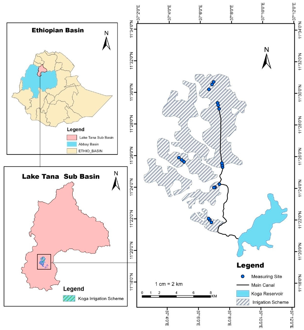
This study was carried out in the Koga irrigation scheme, located in the Koga watershed of the Tana subbasin, Ethiopia. The canal network of the scheme comprises one main canal, twelve secondary (so-called blocks), several tertiary canals, and quaternary canals which finally supply the crop water demand at the irrigation fields through field canals [
4]. The quaternary canals have open free turnouts, with no method to monitor water flow through them. In Koga, irrigation water is distributed to all quaternary canals at a time while a rotational flow operation is applied among the farmers’ fields within a quaternary canal.
Figure 1 shows the flow measurement sites in the study area. The blue marks in the map of the Koga irrigation scheme denote the locations of canal flow measuring sites where V-notch weirs were installed and the DischargeApp setup was made consecutively.
2.2. Data Collection
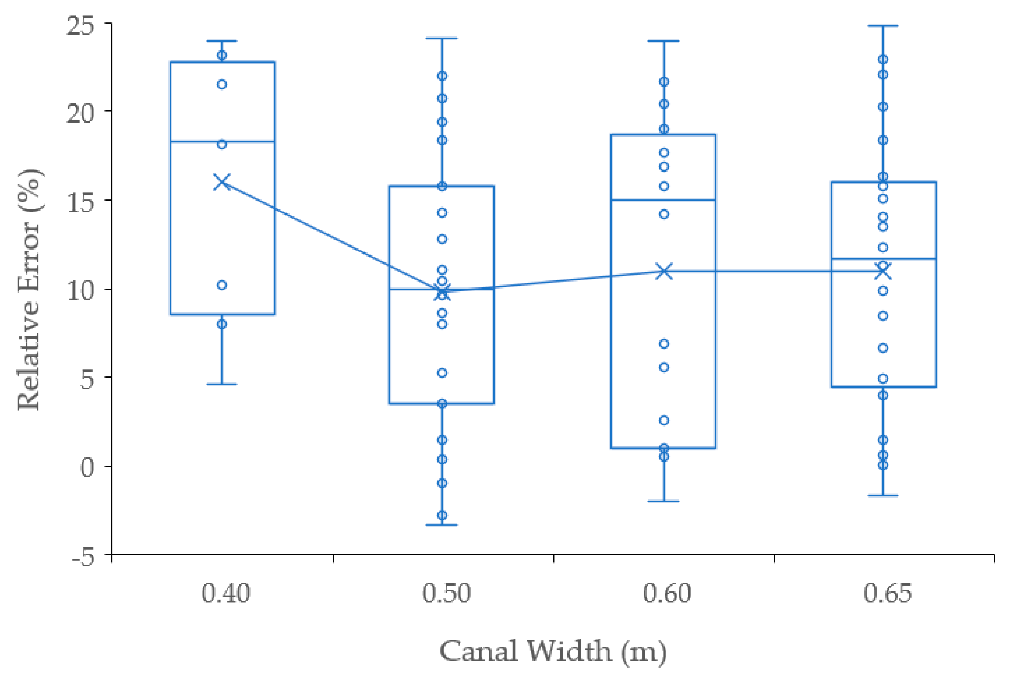
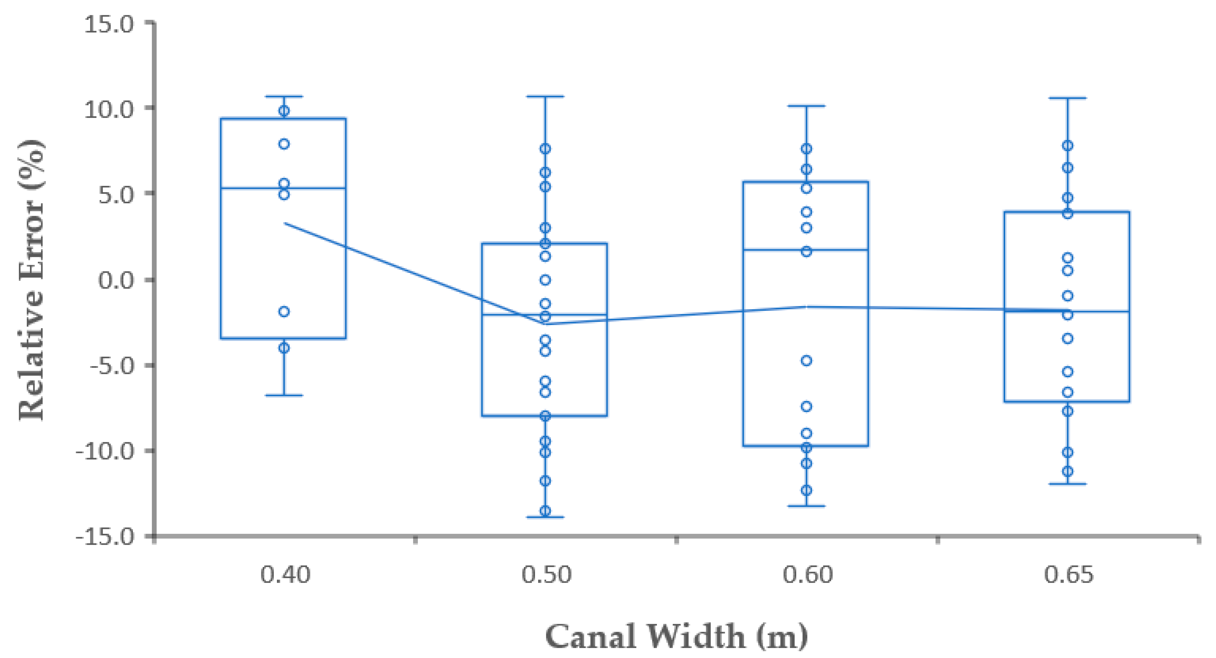
Since the data collection process for this study was part of the International Water Management Institute (IWMI) Water Productivity Gap Filling Project, the experimental setup was made at 6 of the 12 available irrigation blocks, specifically the Kudmi, Chihona, Adibera, Tagel, and Teleta blocks in the Koga irrigation scheme, which were previously chosen based on the project’s objectives. The irrigation blocks were selected using a systematic sampling technique that included different reaches; two blocks from the head, middle, and tail reach of the scheme. Each irrigation block has a number of branching canals known as tertiaries, which, in turn, are composed of quaternary canals. In this study, 18 quaternary canal outlets were selected, one from each tertiary canal and three from each block. The field setup was appropriately planned well at different sections of the scheme to observe the spatial and temporal variability of water supply through the canal outlet structures. Though the turnouts at the entrance of quaternary canals were designed to deliver the same amount of discharge, the actual irrigated command areas under the quaternary canals varied between 6.73 and 16.55 ha. A 90-degree thin plate V-notch weir and smartphone-based, non-intrusive application device, hereafter called the ‘DischargeApp’, were used to measure the flow rate.
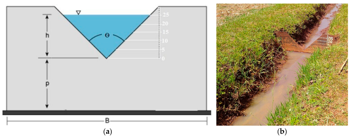
When monitoring relatively low flows, a thin plate 90-degree V-notch weir provides the most precise results (usually 2–5% accuracy). It is also less susceptible to flows with substantial velocity distribution and irregular channel geometry. Additionally, it is practical to use and reasonably simple to manufacture using readily available materials [
9,
10,
23]. For this study, the V-notch weirs were manufactured from a 3mm thick metal sheet with standard dimensions as shown in
Figure 2. This V-shaped notch in a vertical thin plate was installed perpendicular to the sides and bottom of a straight canal. The line which bisects the angle of the V-notch was set vertically and at the same distance from both sides of the channel. Because water significantly pooled upstream of the weir during erection, we adjusted the notch height (p) to 2–5 cm, causing little to no disruption to the canal’s flow operation. The opening height of the weir (h) was 30cm, graduated with a difference of 5 cm, and internally sub-graduated at a 1 cm interval. The notch angle (Ѳ) was made 90 degrees to allow a larger discharge capacity with the opening height (h), and the total width (B) of the weir was 1 m taking into account the width of the canals and channel side to support installation.
The notch weirs were installed at 18 selected quaternary canals, just near the respective entrance of the canals throughout the irrigation season. To convert water depths observed at the V-notches to discharge, as illustrated in Equation (1), a general weir equation was simplified in the SI unit system [
23] using:
where Q is weir discharge in m
3/s at the quaternary canal and H is the effective water head at the weir in meter, which is read from the graduated notch.
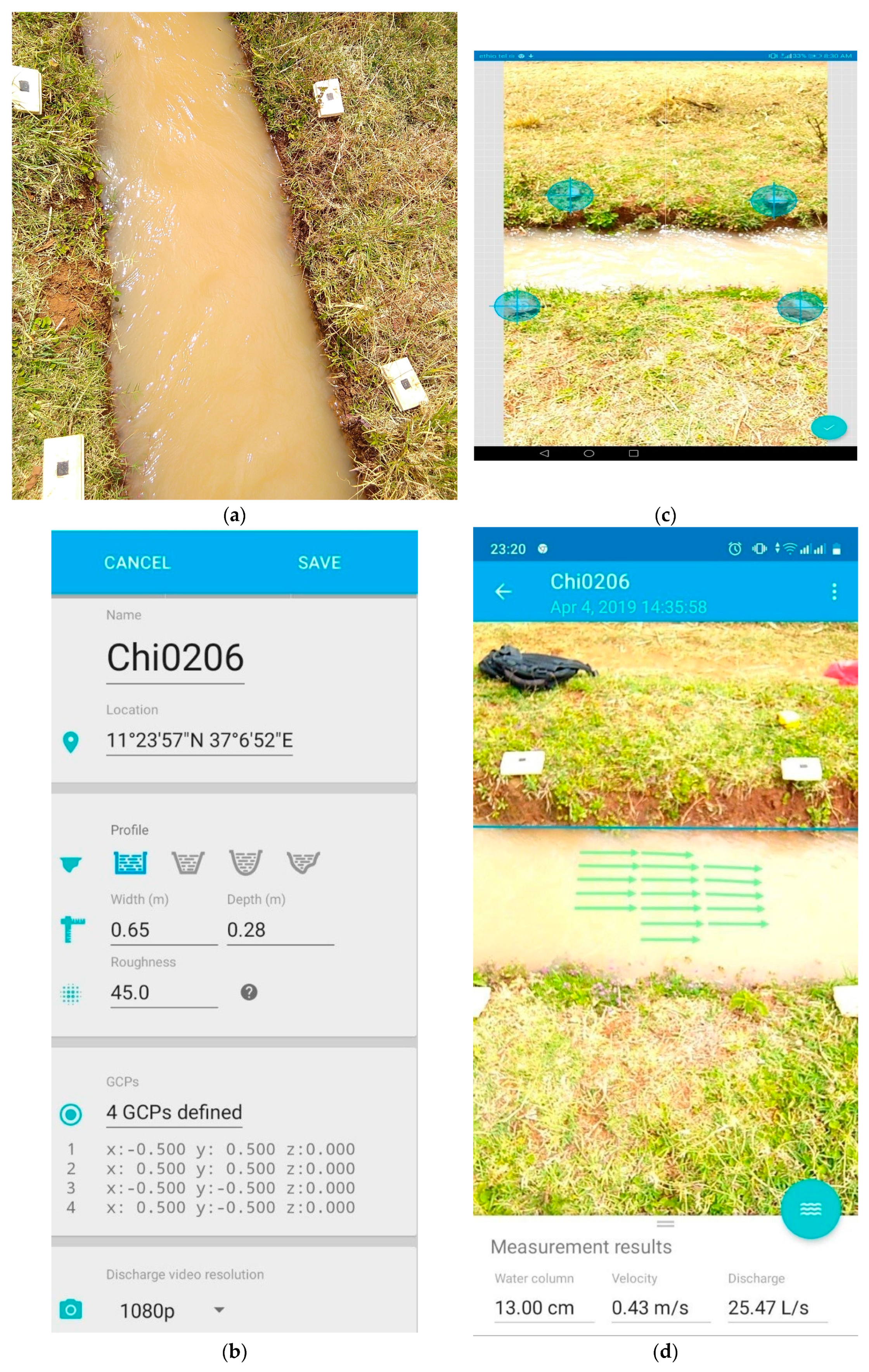
The accuracy of the app was evaluated by Maxence et al. [
12] under a controlled environment with laboratory flumes. Before performing discharge measurements using the DischargeApp, four visible reference markers were prepared. The reference markers were placed on the banks of the canal at a quaternary canal having a nearly uniform cross-section. In order to reduce the weir’s backflow impacts on the surface flow velocity readings, the measurement using the DischargeApp was taken downstream of the 90-degree V-notch weir, often at a distance of 2 to 5 m. The channel geometry, offshore distances of markers, and roughness of the channel bed had necessarily been registered in the internal setup of the app. The Manning–Strickler roughness coefficient, Kst, values were obtained from previous soil test results and inserted into the app using the roughness menu to determine the average velocity of the vertical section [
12]. The bed material for earthen quaternary canals in the study area falls under the fine gravel class with ca. 10/20/30 mm. There was no significant variation in the roughness coefficient values (Kst = 45m
1/3/s between the canal beds due to the fact that the material was mined from similar soil quarries.
Water level and surface velocity measurements were made in quaternary canal flow on a weekly basis using the free DischargeApp with a limited number of data collection capability and the 90-degree V-notch weir, respectively, in all 18 experimental sites during the irrigation season from January to May 2019. The canals were unlined and typically ranged in width from 40 to 70 cm and in depth from 20 to 40 cm. The size of the canals varied gradually due to stripping them in different irrigation seasons. In total, 76 pairs of discharge data were observed using the two methods on 5 distinct dates. The dates were on the 2nd of February, the 7th, 13th, and 27th of March, and the 4th and 15th of April.
2.3. Operation of DischargeApp Using the Smartphone
The DischargeApp application was first downloaded from the google play store and the user created an account on an android device which met the requirement of the application discharge (Android 4.1 or higher). A Huawei MediaPad M3 Lite 10 tablet with specifications of android 7 and 1200 × 1920 pixels resolution was used for the study. The data collector was then registered to the free DischargeApp to get permission for measurements. Finally, the data collector created a new site with a physical presence at the actual site and then filled in the canal information using direct measurements (
Figure 3a,b). Short video records were made using a Huawei tablet by clicking the camera icon after the observer stood at the appropriate place viewing the four markers and the moving water (
Figure 3a). After completing the video records, the camera view was calibrated by moving the visible blue hairs over the placemarks (
Figure 3d). The water column was picked by moving the blue line to the actual water level of the canal (
Figure 3c).
The actual water level was measured using a ruler at multiple places across the canal width, and the average value was input into the app using the water column menu. The video recording and processing were performed within two minutes on average. The 1080-pixel video resolution was used to obtain better-quality data processing. However, using the DischargeApp to operate flow measurements and manage sites is only possible after making the initial annual payment in accordance with the user’s plan. For several measurements in water management projects in the global south, in terms of the app’s payout rate of 2 Swiss Francs (CHF) per measurement for +5 sites/+100 measurements, though not that expensive, there was no special consideration made when setting the rate for citizens who would find it difficult to collect data regularly. For the current study, the International Water Management Institute purchased a premium plan and paid 200 CHF.
The Surface Structure Image Velocimetry (SSIV) algorithm was used to estimate surface flow velocity with the smartphone. The mean flow velocity was computed using velocity coefficient factors. The ISO standard recommends the value of the velocity coefficient factor to be between 0.8 and 1 for a given channel type. The current version of the DischargeApp uses a constant velocity coefficient factor with a value of 0.8 for all types of channels. Finally, the canal discharge was calculated based on the water level, mean flow velocity, and user-defined channel geometry.
2.4. Data Analysis
The accuracy of the app was described using the relative errors (Er), mean absolute error (MAE), and mean absolute percentage error (MAPE). The lower the relative error, the higher the app discharge accuracy. The relative error in Equation 2 indicates the deviation of the app discharge from the V-notch discharge as:
where, Er is the relative error (%),
Qapp is the app discharge (l/s), and
Qvn is the V-notch discharge (l/s).
The mean absolute error (MAE) describes how big the average magnitude of the change between the observed and predicted values is without considering directions in the units of interest. This helps to describe the error level with a single average value. On the other hand, the mean absolute percentage error (MAPE) is a relative error metric that uses percentage units rather than the variable’s units to express the absolute mean differences between the observed and predictable variables. Both MAE and MAPE values describe the mean of the dispersion between predicted and observed values, which is most commonly used to measure prediction accuracy.
Calibration Equation: A linear relationship between the V-notch and discharge app was developed as:
where
Qapp is the app discharge (l/s),
Qvn is the V-notch discharge (l/s), ɛ is an error term, and
and
are coefficients representing the intercept and slope terms of the linear function, respectively.
A simple calibration equation was developed by removing the intercept value in a linear regression equation. A non-zero value of the intercept implies there is a flow by the V-notch discharge while the value of the app discharge remains zero (no flow). Thus, removing the intercept value was required to give a real meaning between the V-notch and app measurements. The simplified calibration equation was described as:
The strength of the relationship between the two measurement methods was evaluated using regression metrics such as the root means square error (RMSE) and coefficient of determination (R2).
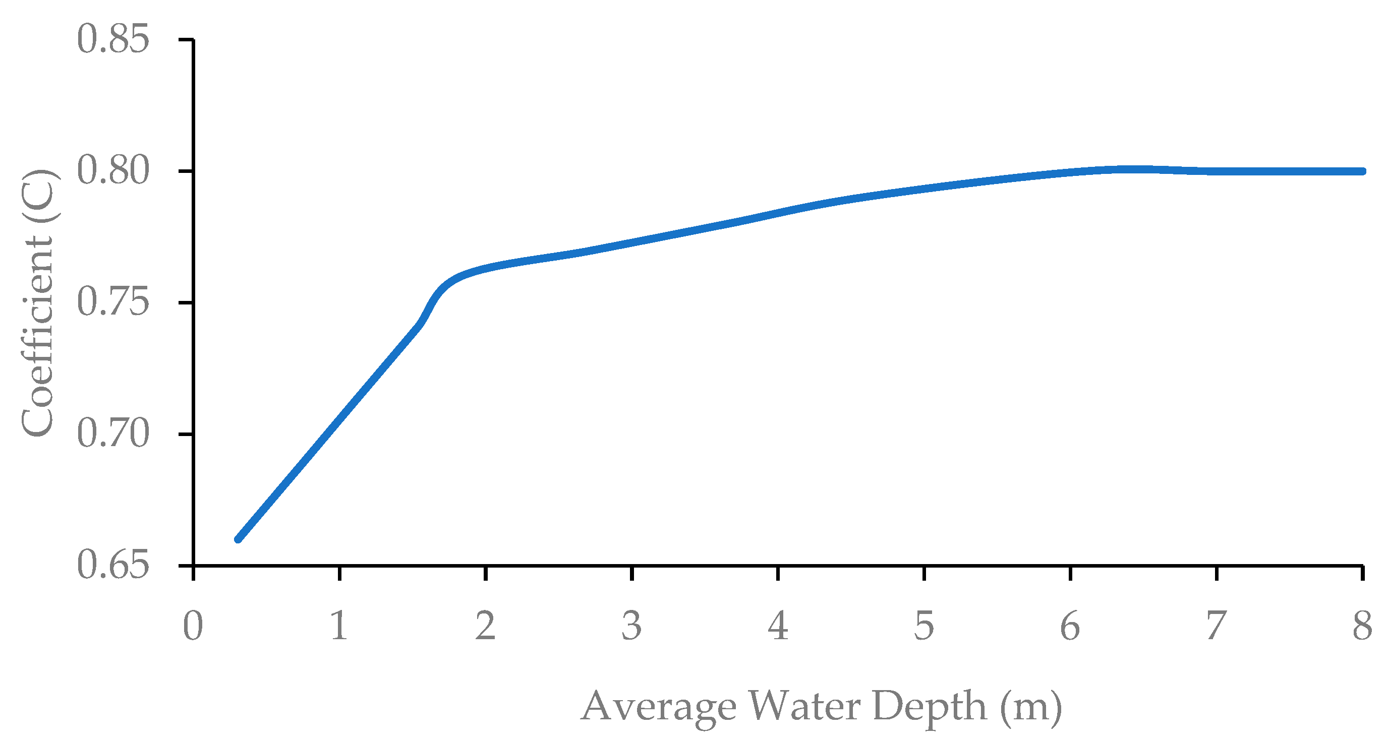
The correction coefficients of surface velocities, which rely on the water depth of the channel, were also applied to improve the accuracy of the DischargeApp (
Figure 4).
4. Discussion
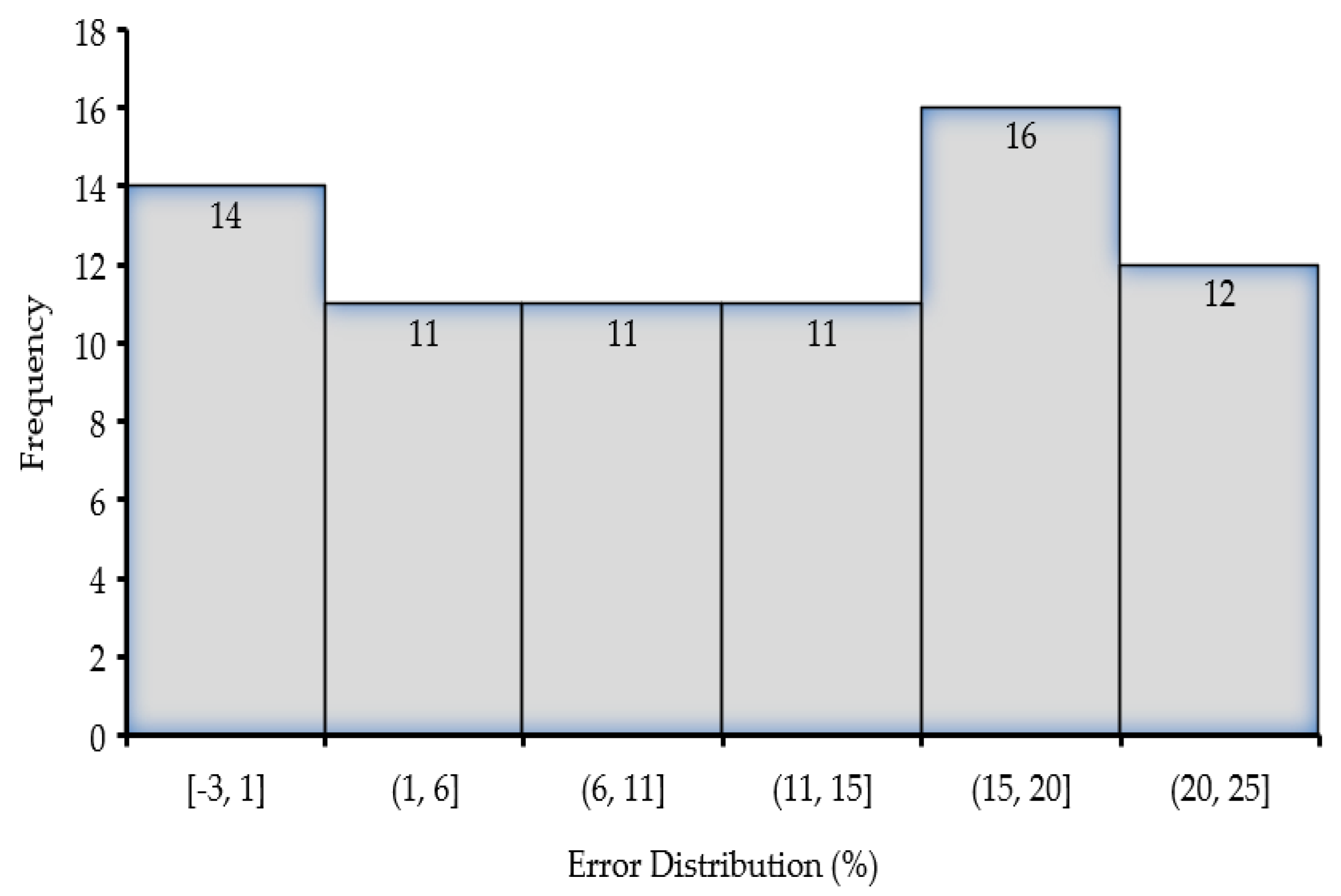
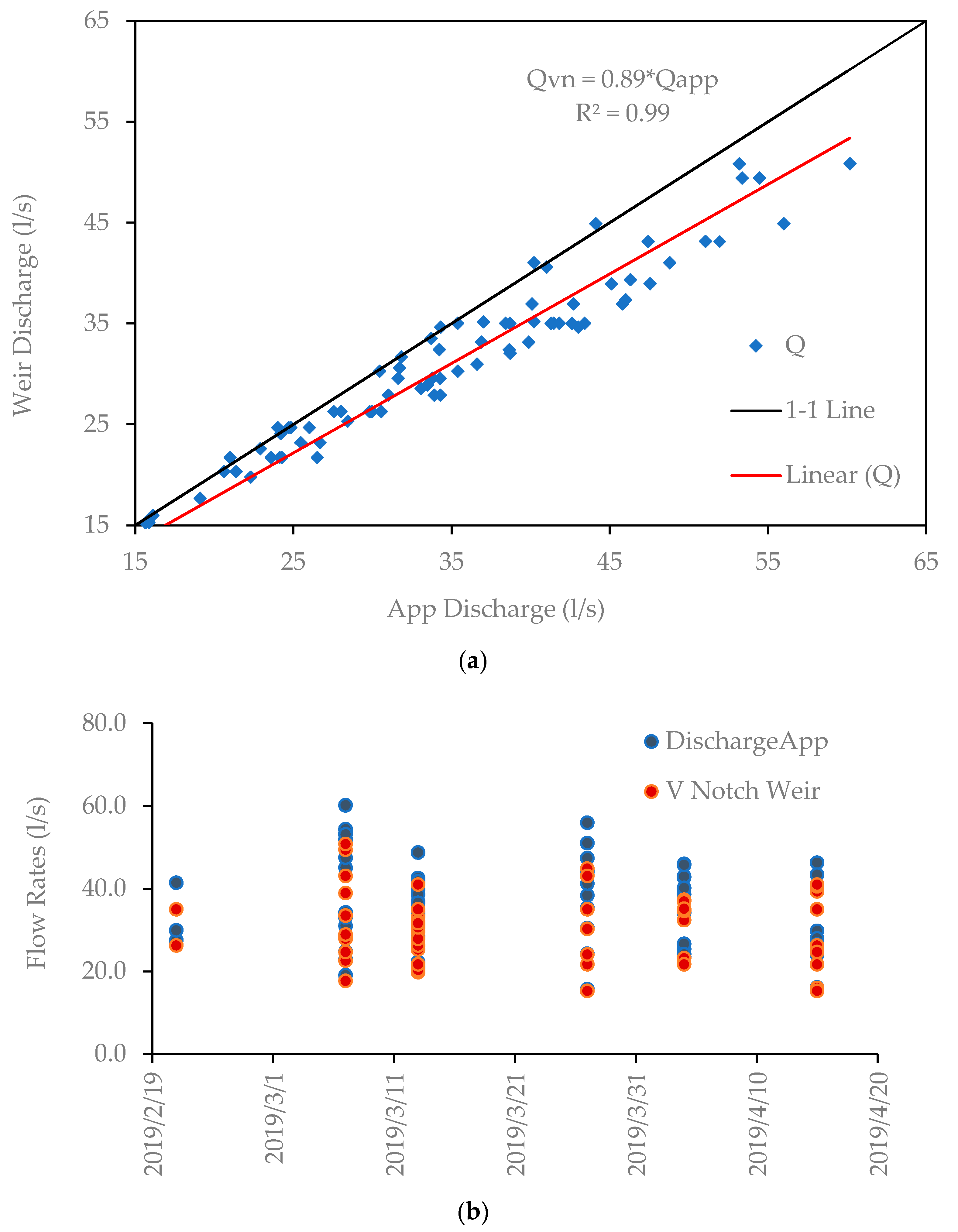
The evaluation of the high-tech smartphone app “DischargeApp” in low-flow irrigation canals of the Koga scheme in northwestern Ethiopia showed that the DischargeApp had an acceptable agreement with the V-notch weir, with mean absolute percent error of 11.4 percent (
Figure 5). This accuracy was quite similar to experimental research conducted in a controlled hydraulic laboratory flume [
12], which represented lined irrigation canals with flow rates of 20–120 l/s.
Figure 6b shows that in the month of early March, there were slightly larger discharge measurement variations between the two devices. This was perhaps caused by the fact that agronomists and flow operators increased the flow when crops were in the flowering stage, although a precise investigation of the crop growth stage and water demand is required. On the other hand, the two discharge measuring systems were mostly in agreement with low flows in April, a month during which crop harvesting and irrigation started to decline.
Additionally,
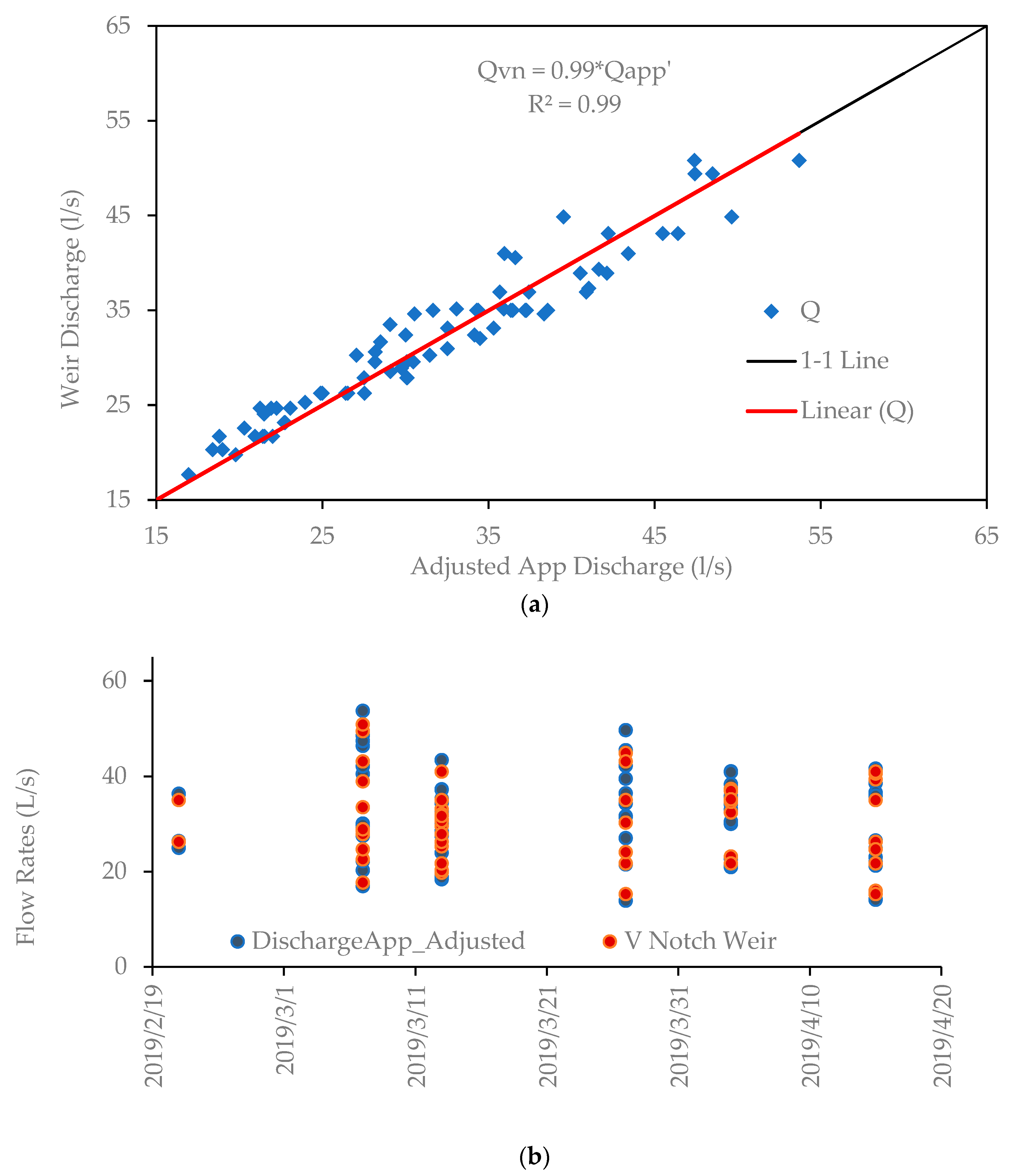
Figure 6a shows that the app’s accuracy decreased at flow rates higher than 40 l/s, and the error appeared to be consistent. As a result, we looked more closely at the DischargeApp’s internal formation. Finally, it was found that the app employed a constant surface flow velocity coefficient (C = 0.8) to estimate discharge, which would be the cause of systematic errors. Yet, studies showed that the velocity coefficients were significantly varied with water depth conditions [
9]. By recalculating the app discharge with the new method, the accuracy of the app was significantly improved (
Figure 8).
The DischargeApp and the V-notch weir have acceptable accuracies at low flows in the Koga irrigation scheme. However, the latter method was found to be challenging for citizens because of the backflow effects on the operation of the canal flow. Furthermore, installing and maintaining the V-notch weir at various locations required significant financial costs. The app was reasonably easy to use, accurate, flexible for different canal flow operations, and low-cost to install and maintain. Though irrigation needs a relatively precise water flow measurement method, the overall adjusted accuracy of the DischargeApp can be used, particularly in data-scarce irrigation schemes, where canal water flow is not regulated [
6]. We also believe that the present evaluation study on the applicability of the DischargeApp increases the trust of citizen scientists who are applying it across the globe for monitoring low-to-medium scale river discharge [
16,
17].
For large-scale rivers, the DischargeApp device which has an IP camera and infrared beamer is more advisable to gauge the river at a fixed location to read water levels [
24]. Based on the authors’ observation, the accuracy of the DischargeApp is affected by environmental factors, such as wind, light, and waves. When objects like grasses at the offshores are moved by the wind faster than the flow of water, the app traces the velocity distribution of grasses rather than water. Moreover, the app is currently used in the daytime, but it can also be applied under different conditions (day and nighttime measurements) if it can be furnished with the most recent system known as the ‘Technology Readiness Level (TRL) of 9′ [
24].


