Article

Environmental Risk Assessment of Wetland Ecosystems Using Bayesian Belief Networks

by
Bahram Malekmohammadi
1,
Cintia Bertacchi Uvo
2,3,
Negar Tayebzadeh Moghadam
1,
Roohollah Noori
1,4 and
Soroush Abolfathi
5,*
1
Graduate Faculty of Environment, University of Tehran, Tehran 1417853111, Iran
2
Finish Environment Institute, 00790 Helsinki, Finland
3
Division of Water Resources Engineering, Faculty of Engineering, Lund University, Box 118, SE-22100 Lund, Sweden
4
Faculty of Governance, University of Tehran, Tehran 1439814151, Iran
5
School of Engineering, University of Warwick, Coventry CV4 7AL, UK
*
Author to whom correspondence should be addressed.
Hydrology 2023, 10(1), 16; https://doi.org/10.3390/hydrology10010016
Submission received: 10 September 2022 / Revised: 3 January 2023 / Accepted: 4 January 2023 / Published: 7 January 2023

Abstract

:
Wetlands are valuable natural capital and sensitive ecosystems facing significant risks from anthropogenic and climatic stressors. An assessment of the environmental risk levels for wetlands’ dynamic ecosystems can provide a better understanding of their current ecosystem health and functions. Different levels of environmental risk are defined by considering the categories of risk and the probability and severity of each in the environment. Determining environmental risk levels provides a general overview of ecosystem function. This mechanism increases the visibility of risk levels and their values in three distinct states (i.e., low, moderate, and high) associated with ecosystem function. The Bayesian belief network (BBN) is a novel tool for determining environmental risk levels and monitoring the effectiveness of environmental planning and management measures in reducing the levels of risk. This study develops a robust methodological framework for determining the overall level of risks based on a combination of varied environmental risk factors using the BBN model. The proposed model is adopted for a case study of Shadegan International Wetlands (SIWs), which consist of a series of Ramsar wetlands in the southwest of Iran with international ecological significance. A comprehensive list of parameters and variables contributing to the environmental risk for the wetlands and their relationships were identified through a review of literature and expert judgment to develop an influence diagram. The BBN model is adopted for the case study location by determining the states of variables in the network and filling the probability distribution tables. The environmental risk levels for the SIWs are determined based on the results obtained at the output node of the BBN. A sensitivity analysis is performed for the BBN model. We proposed model-informed management strategies for wetland risk control. According to the BBN model results, the SIWs ecosystems are under threat from a high level of environmental risk. Prolonged drought has been identified as the primary contributor to the SIWs’ environmental risk levels.

1. Introduction

Wetlands provide key environmental benefits including water purification and pollution removal, flood protection, shoreline stabilization, groundwater recharge, stream flow maintenance, and ecological enhancement [1,2]. Vegetation, soils, and the microbial communities in wetlands facilitate the treatment of water and wastewater run-off. The hydraulics and hydrological processes in wetlands offer a low-emission and sustainable alternative to traditional wastewater treatment plants and can accelerate the natural biodegradation of pollutants [3]. However, anthropogenic activities, urbanization, and industrial developments have resulted in decades of environmental degradation and the loss of wetlands [4,5,6]. Wetlands are rapidly disappearing due to the stress-inducing environmental and ecological alterations from activities such as dredging and filling operations, hydrologic modifications, pollutant runoff, eutrophication, impoundment, and fragmentation by roads and ditches [4,6,7,8]. Therefore, wetland conservation has received significant research attention and political interest in recent years to protect these important natural capitals and facilitate sustainable ecosystem function in wetlands [9].
Environmental decision-making and conservation management for wetlands are highly complex and multi-faceted, requiring an integrated approach that considers a wide range of parameters and processes that influence the ecosystem health and functions of wetlands [10]. A robust risk management plan and environmental protection programs are shown to be effective in reducing the adverse impacts of anthropogenic activities on wetlands [11,12]. The assessment of wetland environmental risk levels involves estimating potential hazards or threats posed by stressors to biotic and/or abiotic components of the wetland [13]. To date, most existing studies have focused on the ecological, structural, and functional characteristics of wetlands and natural ponds [2,8,14,15,16]. However, limited studies are carried out to identify, quantify, and assess the environmental risks to wetlands [17,18,19]. According to the U.S. Environmental Protection Agency (EPA), wetland environmental risk assessment should provide a quantitative or qualitative evaluation of the actual or potential adverse effects of stressors on a wetland ecosystem.
Recently, there has been increased interest in the use of graphical tools such as Bayesian networks (BNs) in natural resource modeling and management [20]. BN’s capabilities for accurate decision-making when complex multi-dimensional uncertainties exist in a system make it an ideal method for the assessment of risk levels in wetlands. BNs use two types of networks, namely Bayesian decision networks (BDNs) and Bayesian belief networks (BBNs). BBNs are an efficient and accurate tool for analyzing risk models, offering a pragmatic and scientifically credible approach for modeling complex systems where substantial uncertainties exist [21,22,23,24,25].
Pollino and Hart [26] examined the performance of BNs models for ecological risk assessments and concluded that BNs are ideal for scenario-based ecological risk management, where scenario analysis is a key element required for assessing risks. Pang and Sun [27] adopted BBNs for environmental flow decision-making, considering seasonal water use conflicts between agriculture and ecosystems. Lehikoinen [28] proposed a BNs model for the environmental risk assessment of the Gulf of Finland, with the aim of devising robust, model-informed environmental management protocols. Sarkar et al. [29] used remote sensing data and GIS tools to develop a fuzzy-based risk assessment model (FRAM) to identify the spatial variability of wetland conversion risks in the East Kolkata Wetland Area (EKWA). It was shown that FRAM efficiently modeled and mapped various levels of wetland risk zones in the EKWA. Yet et al. [30] adopted a dynamic and hybrid BNs framework for cost-benefit risk analysis in an agricultural development case study. They used both continuous and discrete variables in their model.
BBNs consist of a graphical model and a fundamental probabilistic structure. The graphical model represents the most significant variables in the system and the causal links between the nodes that are explained using conditional probability tables (CPTs). Empirical data, models, and expert technical inputs (when measured data is not accessible) are sources of information for producing CPTs [22,23,31]. The key benefits of BBNs for their application in wetland conservation and risk level analysis are the integration of different types of variables and data within a single framework, robust accounting for uncertainty, and the ability to be updated when new information and knowledge become available [32]. These key features make BBNs an ideal tool to assist decision-making in natural resource management, where complex problems exist with insufficient and uncertain data. The applications of BN’s framework in participatory modeling have been successfully tested by Borsuk et al. [33] and Jensen [34].
This study aims to develop a probabilistic decision support model using BBNs to identify, quantify, and analyze the environmental risk levels of wetlands. The proposed model is adopted for the case study of the Shadegan International Wetlands (SIWs), located in southwestern Iran, which is a Ramsar site of significant ecological value. Key environmental variables and the relationships amongst them are identified through the expert judgment of five environmental specialists, and an influence diagram (ID) is developed. The BBNs are developed through determining the states and probability distribution tables, and environmental management strategies are proposed to reduce the risk levels for the SIWs.

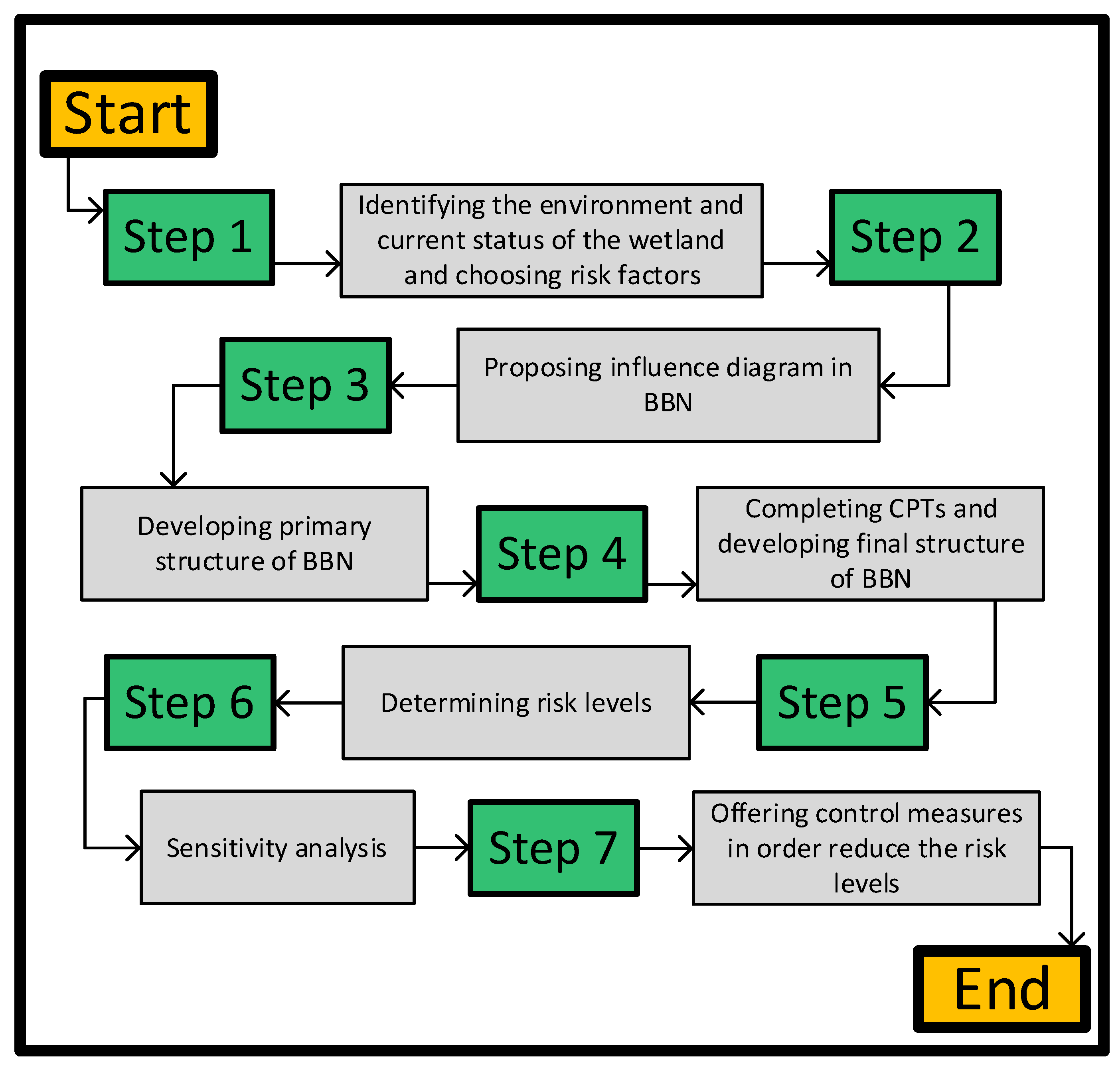
2. Materials and Methods

Study Area

The Shadegan International Wetlands (SIWs) are located in Khuzestan Province, southwest of Iran, between 48°20′ and 49°20′ E longitude and 30°50′ and 31°00′ N latitude. Figure 1 shows the geographical location and characteristics of the study area and the wetland catchment. SIWs are located in the Jarahi River Delta, with very flat land and a low-gradient plains’ topography. The Jarahi basin has an area of approximately 24,310 km2 and is in the southern parts of the Zagros Mountain Range. The SIWs cover about 5377 km2, of which almost 61% is protected as a wildlife refuge [35].
The SIWs have important hydrological, biological, and ecological significance as a Ramsar site and in terms of maintaining normal ecosystem functions in the surrounding river basin and coastal system. The unique diversity of this wetland includes plant and animal species specific to freshwater, brackish, and saltwater environments. SIWs are listed in the Montreux Record [36], and currently, they are under significant existential threat from several environmental risks. The recent surveys of SIWs show that despite unique and outstanding ecological values and ecosystem function, the wetlands are much degraded and removed from their natural ecological condition due to anthropogenic activities [20]. The expert team consulted in this research identified the most important risk factors that SIWs have faced in recent years, including land use change, water pollution, uncontrolled exploitation, sedimentation, loss of biodiversity, drought, and changes in water flow regimes. The following are brief discussions of the underlying mechanisms that introduced these risks:
Land use change: advancement and encroachment of agricultural lands into wetland areas; construction of infrastructure (including roads, buildings, thermal power plants, factories, power and oil transmission lines, canals, and drains) in the wetland area. Seven oil and petrochemical pipelines currently run through the wetland. Inside the wildlife refuge, communication roads are being built. Shadgan steel factory is developed in the vicinity of a wetland, where surface water accumulation and flood inundation occur around the factory site due to changes in geological characteristics and groundwater levels. Further, urban development and widening of the Abadan-Ahvaz communication road adjacent to the wetland is another factor causing land use changes around the wetland [17,35,37].
Water pollution: wastewater discharges from urban and rural communities into the wildlife refuge release 4.42 million cubic meters of polluted water into the wetland area annually. Agricultural effluents into the wetland are about 6.161 million cubic meters, and livestock farm wastewater of approximately 16.5 million cubic meters enters the wetland. The solid waste disposal and landfilling of the cities in the Shadgan catchment exceeds 245 tons per day. Further, pollution from chemical fertilizers, industrial waste, waste from sugarcane development plants, and drainage flows from the development of the irrigation network and fish farming that directly enter the wetland have significant influences on water pollution across SIWs [34,36].
Uncontrolled exploitation: this includes bird hunting, the introduction of non-native species, the harvesting of fish and shrimp in the freshwater part of the wetland, livestock grazing in the wetland and its margins, and the harvesting of fodder in the upper parts of the wetland [35,37].
Sedimentation: The sedimentation and filling of the wetland by the sediments that supply the wetland’s water; the construction of dams upstream, which has increased sedimentation and sediment accumulation [35].
Loss of biodiversity: Fish breeding activities in the upstream part of the catchment area have led to the introduction of non-native species that compete with the native species of the wetland and have caused biodiversity issues. Road construction inside the wetland, hunting, and the development of fishing ports are also threatening biodiversity at the wetland [17,37].
Drought: The average annual rainfall varies from 160 to 900 mm per year in the wetland watershed area. The occurrence of severe drought, especially during the years 2005, 2006, and 2007, has caused the destruction of a large part of the wetland. The maximum temperature varies from 54 °C in July to a minimum of −8 °C in November. A decrease in rainfall and an increase in temperature have consistently occurred over the past 30 years (1990–2020), which has caused an increase in water salinity. The trend of increasing temperature and decreasing rainfall in this region is predicted until 2040 [35,38].
Reduction of discharge and changes in water flow regime: development of surface water and flood control plans (i.e., storage dams) in the upstream area and extensive irrigation and drainage plans for the upstream lands have led to a reduction of water entering from the main artery of the wetland (the Jarhari River). The flow reduction of the Karun River and the inflow of drainage from the sugarcane development projects, with their high salinity and large volume, have changed the nature of the ecosystem across the freshwater part of the wetland and facilitated salinization and drying [37,38].

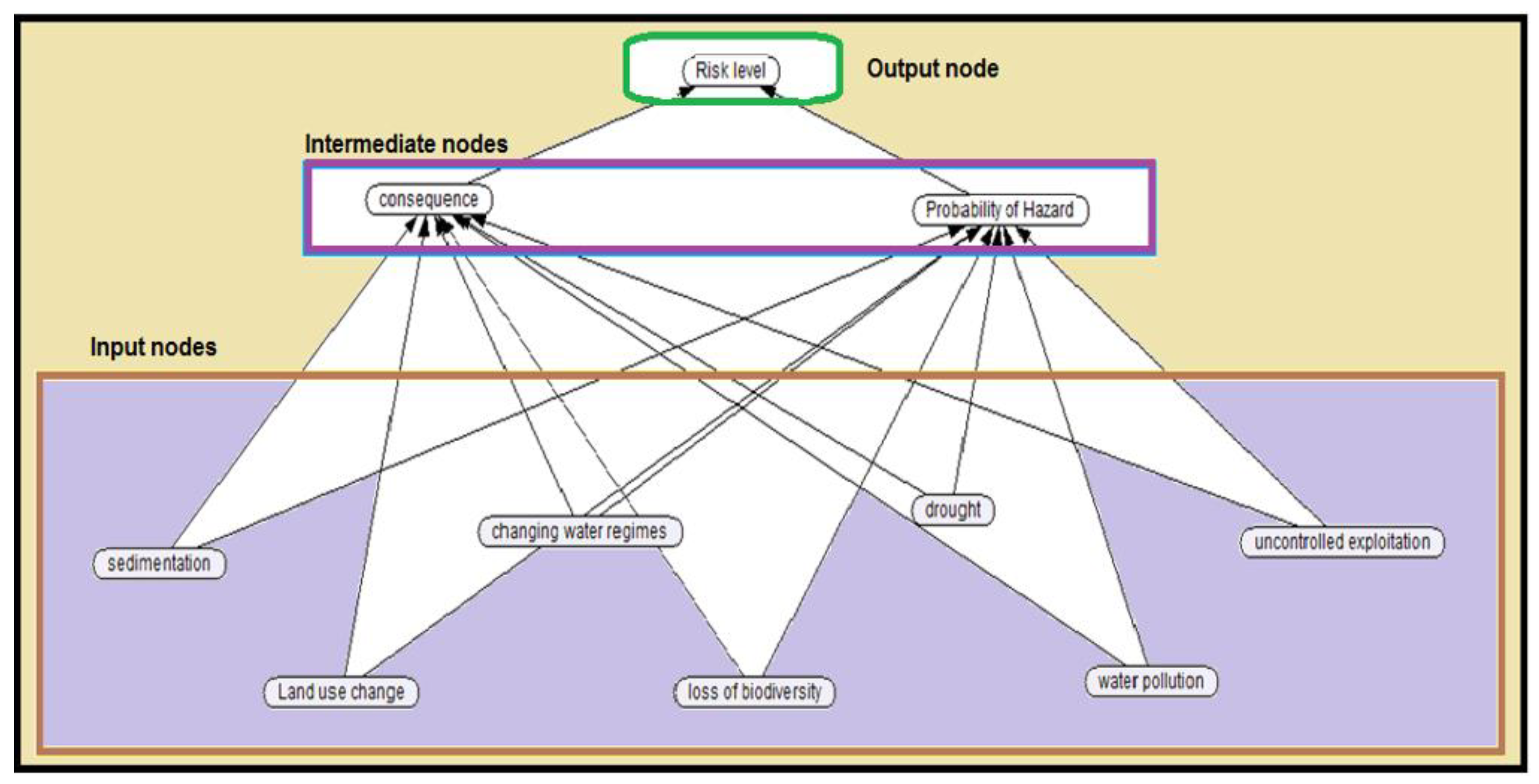
3. Modeling and Analysis

Bayesian Belief Networks (BBNs) are a class of probabilistic graphical models capable of describing conditional dependencies between a set of variables. BBNs use directed acyclic graphs to describe the modeling outcomes. A BBN is a graph consisting of nodes (variables) and arcs. Nodes represent discrete random variables, and arcs depict conditional relationships between variables. Variables that depend on other variables are referred to as "child nodes," while nodes directly preceding them are called "parent nodes." Two variables are independent if they are not directly linked by an arc. The quantitative component is a set of probability distributions that quantifies the strength of the conditional dependencies between variables represented in the directed acyclic graph [30,38]. In general, BBNs are useful for situations in which the current state of the system depends on its previous state. Using BBNs, the posterior probabilities of the output variables can be determined [39,40]. Hence, BBNs, as probabilistic networks, can be utilized for decision-making in environmental management problems where uncertainty in variables can be challenging [41].
This study adopts the BBNs to determine the risk levels of wetland ecosystems. At the beginning of the modeling process, an influence diagram (ID) was developed by selecting variables and determining the causal relationships between them. Selection variables, variables’ states, and relations between nodes were identified through expert judgments (see §3 Results for further discussions).
Three types of nodes are introduced in the network. Input nodes are variables related to wetland conditions and risks. Intermediate nodes are related to variables describing the probability of hazards and consequences, which are the main indicators in determining risk levels. The output node specifies the environmental risk levels of wetlands. Figure 2 shows the schematic of the methodological framework adopted in this study to determine wetland risk levels. The BBNs model proposed in this study is developed using Netica open-source code.
Following the identification of the list of variables influencing risk levels at SIWs, the primary structure of BBNs is developed by determining the causal relationships amongst the influential parameters and the setting states of the variables in the network. To complete the network, the combined possibilities of states are entered for each node in the form of conditional probability tables (CPTs). Interdependencies between the nodes are qualitatively modeled by the links in the network and quantitatively by the CPTs associated with each node. The joint probability distribution captured by the network’s structure and CPTs encodes the domain expert’s knowledge of interdependencies among variables [42]. The associated uncertainty of the system can be examined using CPTs [43].
The development of BBNs, including the selection of nodes, states, relationships between variables, and values of CPTs, is completed with a combination of expert judgments, results from simulation models, literature reviews, and analysis of real data obtained from the case study area. In Bayesian modeling, the existing scientific information in different formats as well as the experts’ judgments are valuable sources of information that can be combined to enhance the output results [44,45]. The ability of BBNs to integrate multiple data types into a model is particularly useful for wetlands conservation and the development of robust decision support tools for environmental management. The environmental risk levels are determined in the form of a probability distribution at the output node of the BBNs. The results of the output node (i.e., risk levels) are used to devise management strategies to control and mitigate the risk factors according to the characteristics of the study area (i.e., SIWs) and based on the existing literature.
Sensitivity analysis is carried out to examine the model’s response to variations in the network inputs and quantify the effects of changes in one variable on other variables. In BNs, sensitivity means that changes in the probabilities of the considered nodes are a function of changes in the values of the conditional probability tables of the network. The sensitivity analysis of the proposed Bayesian model provides information on which variables can strongly influence the behavior of the system and which variables are not very sensitive to changes in the system. By selecting each state of a selected node, the model assumes 100% probability for the state and estimates the consequent probabilities for other nodes in the network. This feature was used in two forms: “predictive model” and “diagnostic model” [46,47]. In the “diagnostic model”, by selecting a state of one or more “child nodes” at 100%, changes are observed in the “parent nodes” of the probability distribution. In the “predictive mode”, the state of one or more “parent nodes” is altered, and changes in probability distributions in “child nodes” are examined [46].

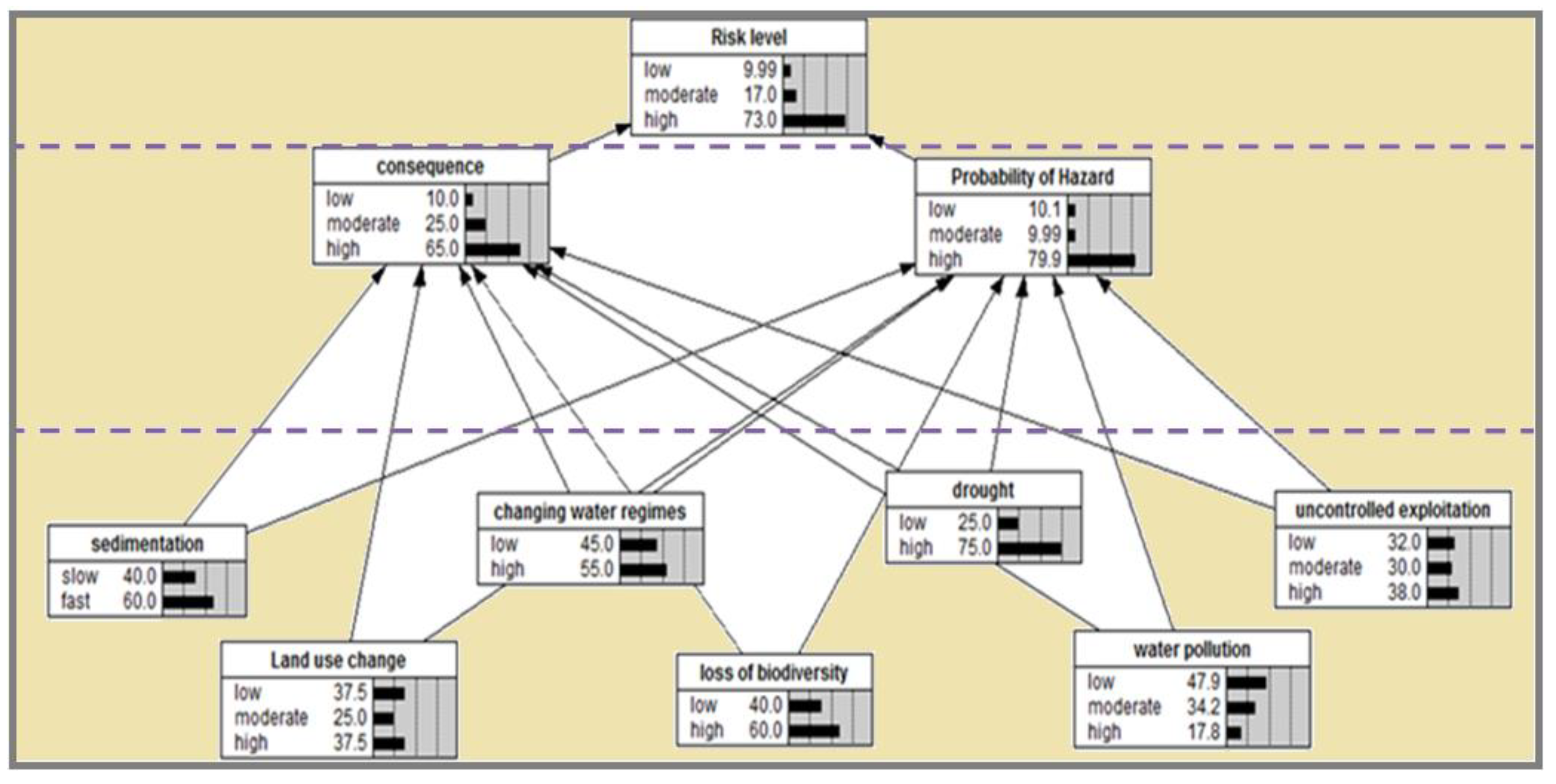
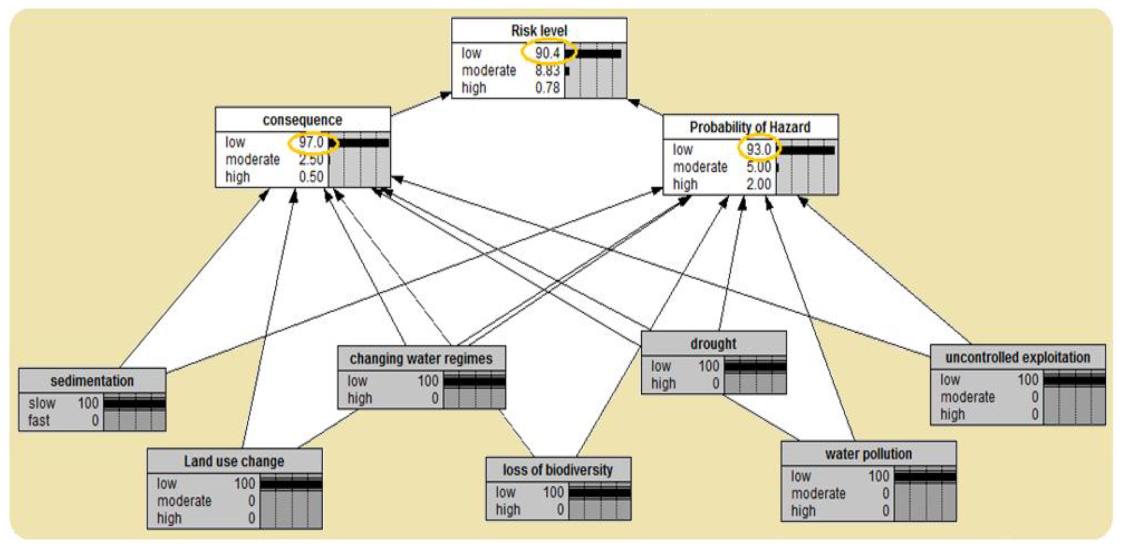
4. Results and Discussion

To determine the levels of environmental risk at the SIWs, initially, the ID of causal relationships was formed in the model. The nodes and arcs between the parameters were selected based on a literature review, the judgments of experts, and the characteristics of the study area. Land use change, water pollution, uncontrolled exploitation, sedimentation, loss of biodiversity, drought, and changing water regimes are identified as the key risk factors for SIWs conservation. Table 1 describes a comprehensive list of the characteristics of the risk factors considered in this study. The probability of hazard and consequence were selected as the main indicators in determining the environmental risk levels. The ID used to determine the levels of environmental risk for the SIWs is shown in Figure 3.
Following the completion of the ID setup, the states of each node were determined to form the initial BBN model. A range of states were considered for each node based on the data from expert judgments and the literature. Figure 4 illustrates the initial BBN developed to determine the levels of environmental risks at the SIWs. Once the network structure was completed, the probabilities of risk factors were entered into the network in the form of CPT codes for each node in the network. The quantitative relations between variables were modeled by the CPT associated with each node. The child node was assigned a probability for each possible combination of each parent state. The probability percentage values considered in the model were estimated based on expert judgments and background field study data from the SIWs. The BBN model developed for this study considers the states at each node. For instance, in the risk level node, three states (i.e., low, moderate, and high) are specified. The CPT of the risk level node is shown in Figure 5.
The risk level node is influenced by two nodes, including the probability of hazards and consequences. By combining the states of the nodes in BBN, several scenarios for the risk level node are considered. The probability distribution obtained from the output node (risk level) indicates that the risk level is very high for the SIWs (Figure 6). The results show that the risk levels for the SIWs are about 10%, 17%, and 73%, respectively, for the low, moderate, and high states (Figure 6). The results shown in Figure 6 highlight the drought as the highest (or fastest) state of risk for the SIWs, with 75%, followed by sedimentation (60%), loss of biodiversity (60%), changing water regimes (55%), uncontrolled exploitation (38%), land use change (37.5%), and water pollution (17.8%).
To understand the sensitivity of the BBN in the "predictive model," each risk factor was assumed to be 100% at the low (i.e., slow) state; it was expected that the low states’ probability of hazards and consequences, as the child nodes, would be significantly reduced. Figure 7 shows the predictive model determined for the sensitivity analysis of the environmental risk levels at the SIWs. The results show that when the low state values in risk factors were changed to 100%, the two low state values of the parent nodes (probability of hazard and consequence) were altered to 93% and 97%, respectively. Also, with a significant reduction in the probability of hazards and consequences, the risk level in the low state changed to 90.4%.
Figure 8 presents the diagnostic model for determining the environmental risk levels of the SIWs. For this model, in the risk level node, the high state was assumed to be 100%, so the probability of hazards and consequences in the high state were increased to 93.6% and 77.4%, respectively. According to the results of the sensitivity analysis shown in Table 2, the probability of hazard has a greater impact on the level of risk. The results highlight that, among the risk factors, drought has a greater effect on the environmental risk levels of the SIWs.
We propose management strategies to reduce risk levels and manage the environmental risks of the SIWs based on the results gathered from BBNs, the characteristics of the study area, existing data, and expert opinions (Table 3). This research highlights the significant role of prolonged droughts as a climatic stressor that adversely influences the environmental preservation of SIWs. As such, it is proposed that harvesting water from the SIWs should be banned, specifically during the drought forecast period. To limit the environmental damage caused by drought, changes in flow regimes, such as construction of hydraulic structures (e.g., dams, control structures), must be avoided across the SIWs. A robust hydrological and drought monitoring network within Jarahi Basin is necessary to improve management and planning for the SIWs’ preservation. Furthermore, water transfer into wetlands from areas with high (or higher) water levels during drought is recommended to reduce the environmental risk levels imposed by drought.
BBNs are a robust and effective probabilistic modeling technique for determining the levels of environmental risks in different ecosystems and assessing the potential outcomes of alternative management actions. The capabilities of BBNs in providing the possibility of combining different types of data, evaluating modeling uncertainty, and updating the model when new knowledge and data become available make BBNs an ideal tool for examining risk factors across complex environmental domains. As such, BBNs can represent multiple environmental risk factors in complicated wetland systems as a whole without the need to fully capture and illustrate all the underlying processes in the system. The associated uncertainty in the environmental risk factors of a wetland ecosystem can be indicated and quantified using CPTs.
To protect and manage wetlands in a sustainable manner, it is necessary to quantify and reduce levels of environmental risk that impact the wetlands’ health and function. In this study, a BBN model was developed to determine the relative levels of environmental risk, which were defined by considering the categories of probability and severity. To standardize the risk levels and their value, three distinct states, including low, moderate, and high, were adopted for BBN. This study utilized BBN to model environmental risk levels for a case study of SIWs, which is a Ramsar site of high environmental and conservation significance. The BBN results show a high level of risk (73% at high state) for SIWs, emphasizing the critical need for SIW risk management strategies. The analysis of risk levels and the available survey data for SIWs show that without robust interventions, the environmental condition and ecological health of the wetlands will worsen. Changes in land use and the increased development plans across the SIWs area are key parameters affecting the wetland’s health and function.
The BBN model developed in this study determined drought as the main risk factor influencing the SIWs ecosystem. Prolonged drought in Jarahi’s Basin has been a chronic problem in recent decades, which will be exacerbated by the long-term effects of a changing climate. Previously, Malekmohammadi and Rahimi Blouchi [17] conducted an environmental risk assessment for Shadgan wetland and concluded that the most important risk was the construction of a dam and irrigation network. Given that Iran and especially the southern regions of the country have faced prolonged drought and low rainfall in recent years, which have led to the drying up of a significant part of the Shadegan wetland, this study identified drought as the most important risk. Preventing the harvest of water from the SIWs, designing a hydrological and drought monitoring network in the Jarahi Basin, and preventing deforestation and erosion upstream of the SIWs are proposed as the key control measures for reducing the level of drought risk.
Considering the close relationship between the biotope and the biogenesis in wetland ecosystems and the interconnectivity between the upstream and downstream interacting processes of wetlands, a catchment-scale environmental management approach is the most appropriate way to sustainably manage wetlands’ dynamic ecosystems. Monitoring risk levels in wetland ecosystems with BBNs aids in the implementation of ecosystem-based environmental management strategies. Implementing risk management strategies can help improve the current conditions at wetlands, reduce risk levels, and prevent further degradation of these valuable natural capitals.
In developing BBNs for assessing the environmental risk levels of wetland ecosystems, consideration must be given to identifying the most influential variables and their interdependencies for designing and refining the network and constructing CPTs in the model. The developed BBNs can be considered a decision-support tool that helps devise robust environmental management protocols. New variables (i.e., new risk factors) and variables that affect the existing risk factors can be incorporated into BBNs’ model, and the temporal and spatial changes in risk levels can be monitored. Also, the rate of decrease in risk factors and related risk levels can be monitored and evaluated by BBNs when specific management strategies are implemented. Integration of BBNs with conventional methods for environmental risk assessment (e.g., multi-criteria decision-making method) can provide a more comprehensive decision-support tool for monitoring and managing environmental risk factors in wetland ecosystems.
In this study, risk factors are considered independent of each other. However, the proposed model can also consider inter-relationships among the risk factors if a comprehensive dataset on the influential risk parameters exists for the case study location. The proposed BBN model can be adopted as a robust auxiliary tool in determining the status of each risk factor affecting the wetland and determining the final level of wetland risk. The prioritization of different risk factors for environmental management and decision-making will vary as a function of time, budget, and study area characteristics.
The lack of suitable quantitative data for risk factors, and especially for determining the relationships between the variables, is one of the key challenges that environmental risk assessment studies face. As such, it is necessary to provide a set of standardized protocols and rules that can serve as a step-by-step guide for the environmental risk assessments and to specify the influential variables and the relationship between them in the design and refinement of the BBN model. Also, the addition of other advanced statistical models that can be combined with Bayesian networks can help to provide more reliable outputs (e.g., ANN [48,49], GP [50]). For example, using a full probability density function (PDF) for characterizing the risk factors can enhance the quality and reliability of the modeling results. Further research is needed to develop a more holistic environmental risk assessment framework for wetlands that includes both qualitative and quantitative risk assessment approaches.

5. Conclusions

This study proposed a robust methodological approach to determine the overall environmental and conservation risk level for wetlands using BBNs. The risk factors that influence a wetland’s health and function and the relationships between these variables can vary in the proposed model depending on the characteristics of the study area, data from field-based observations, or expert opinions. The complexity in setting up relationships between risk variables is a function of the availability of data, the purpose of the assessment, and the resources allocated for the study. In this study, following the literature review and surveys and examining the study area, the expert team identified the most important risk factors for the SIWs, including land use change, water pollution, uncontrolled exploitation, sedimentation, loss of biodiversity, drought, and changing water regimes. The results show prolonged drought in the Jarahi basin as a key risk factor threatening the ecological function and health of SIWs. Catchment scale management strategies are proposed to reduce environmental risk levels for SIWs.

Author Contributions

Conceptualization, B.M., C.B.U. and N.T.M.; Methodology, N.T.M. and B.M.; Software and Validation, N.T.M., C.B.U. and B.M.; Formal Analysis, N.T.M., B.M. and S.A.; Writing—original Draft, N.T.M., B.M. and C.B.U.; Writing—Review and Editing, S.A. and R.N.; Supervision, B.M., C.B.U. and R.N. All authors have read and agreed to the published version of the manuscript.

Funding

This research received no external funding.

Institutional Review Board Statement

Not applicable.

Informed Consent Statement

Not applicable.

Data Availability Statement

Most datasets used in this research were obtained from publicly accessible repositories. Interested users should check the references section for further information.

Acknowledgments

The first author would like to express his gratitude to the Islamic Development Bank (IDB) for providing a fellowship through the Merit Scholarship Program, which facilitated research visit and collaboration with Lund University. CBU would like to acknowledge partial funding by the Academy of Finland under the HYDRO-RI and GreenDigiBasin projects that are part of the Freshwater Competence Centre.

Conflicts of Interest

The authors declare no conflict of interest.

References

  1. Samsunlu, A.; Akca, L.; Kinaci, C.; Findik, N.; Tanik, A. Significance of wetlands in water quality management—Past and present situation of Kizilirmak Delta, Turkey. Water Sci. Technol. 2002, 46, 145–152. [Google Scholar] [CrossRef] [PubMed]
  2. United States Environmental Protection Agency (USEPA). Methods for Evaluating Wetland Condition: Introduction to Wetland Biological Assessment; Office of Water: Washington, DC, USA, 2002.
  3. Dehestaniathar, S.; Nesari, S.; Borzooei, S.; Abolfathi, S. Application of natural biodegradable fiber as biofilm medium and carbon source in DEnitrifying AMmonium OXidation (DEAMOX) process for nitrogen removal from wastewater. J. Taiwan Inst. Chem. Eng. 2021, 119, 108–114. [Google Scholar] [CrossRef]
  4. Paludan, C.; Alexeyev, F.E.; Drews, H.; Fleischer, S.; Fuglsang, A.; Kindt, T.; Kowalski, P.; Moos, M.; Radlowski, A.; Stromfors, G.; et al. Wetland management to reduce Baltic Sea eutrophication. Water Sci. Technol. 2002, 45, 87–94. [Google Scholar] [CrossRef]
  5. Kalpana, A.; Hussain, S.A.; Badola, R. Resource dependence and attitudes of local people toward conservation of Kabartal wetland: A case study from the Indo-Gangetic plains. Wetl. Ecol. Manag. 2007, 15, 287–302. [Google Scholar]
  6. Caruso, B.S. Science and policy integration issues for stream and wetland jurisdictional determinations in a semi-arid region of the western U.S. Wetl. Ecol. Manag. 2011, 19, 351–371. [Google Scholar] [CrossRef]
  7. Klemas, V. Remote sensing of wetlands: Case studies comparing practical techniques. J. Coast. Res. 2011, 27, 418–427. [Google Scholar]
  8. Kotze, D.C. The application of a framework for assessing ecological condition and sustainability of use to three wetlands in Malawi. Wetl. Ecol. Manag. 2011, 19, 507–520. [Google Scholar] [CrossRef]
  9. Mitsch, W.J. Applying science to conservation and restoration of the world’s wetlands. Water Sci. Technol. 2005, 51, 13–26. [Google Scholar] [CrossRef]
  10. Zsuffa, I.; Van Dam, A.A.; Kaggwa, R.C.; Namaalwa, S.; Mahieu, M.; Cools, J.; Johnston, R. Towards decision support-based integrated management planning of papyrus wetlands: A case study from Uganda. Wetl. Ecol. Manag. 2014, 22, 199–213. [Google Scholar] [CrossRef]
  11. Eldin, N.N.; Eldrandly, K.A. A Computer A Bayesian Belief Network Analysis of Factors Influencing Wildfire Occurrence in Swaziland Aided System for Site Selection of Major Capital Investment. In Proceedings of the 1st ASCAAD International Conference, Dhahran, Saudi Arabia, 7–9 December 2004; e-Design in Architecture: Dhahran, Saudi Arabia, 2004. [Google Scholar]
  12. Chen, S.; Chen, B.; Fath, B.D. Ecological risk assessment on the system scale: A review of state-of-the-art models and future perspectives. Ecol. Model. 2013, 250, 25–33. [Google Scholar] [CrossRef]
  13. Lemly, A.D.; Richardson, C.J. Guidelines for risk assessment in wetlands. Environ. Monit. Assess. 1997, 47, 117–134. [Google Scholar] [CrossRef]
  14. Hanson, A.; Swanson, L.; Ewing, D.; Grabas, G.; Meyer, S.; Ross, L.; Watmough, M.; Kirkby, J. Wetland Ecological Functions Assessment: An Overview of Approaches; Canadian Wildlife Service Technical Report Series no.497, Atlantic Region; Environment and Climate Change Canada: Kelowna, BC, Canada, 2008.
  15. Goodarzi, D.; Mohammadian, A.; Pearson, J.M.; Abolfathi, S. Numerical modelling of hydraulic efficiency and pollution transport in waste stabilization ponds. Ecol. Eng. 2022, 182, 106702. [Google Scholar] [CrossRef]
  16. Goodarzi, D.; Sookhak Lari, K.; Khavasi, E.; Abolfathi, S. Large eddy simulation of turbidity currents in a narrow channel with different obstacle configurations. Sci. Rep. 2020, 10, 12814. [Google Scholar] [CrossRef] [PubMed]
  17. Malekmohammadi, B.; Rahimi Blouchi, L. Ecological risk assessment of wetland ecosystems using Multi Criteria Decision Making and Geographic Information System. Ecol. Indic. 2014, 41, 133–144. [Google Scholar] [CrossRef]
  18. Wang, H.; Song, C.; Song, K. Regional ecological risk assessment of wetlands in the Sanjiang Plain with respect to human disturbance. Sustainability 2020, 12, 1974. [Google Scholar] [CrossRef] [Green Version]
  19. Asumadu, G.; Quaigrain, R.; Owusu-Manu, D.; Edwards, D.J.; Oduro-Ofori, E.; Kukah, A.S.K.; Nsafoah, S.K. Analysis of risks factors associated with construction projects in urban wetlands ecosystem. Int. J. Sustain. Dev. World Ecol. 2022, 1–13. [Google Scholar] [CrossRef]
  20. Keshtkar, A.R.; Salajegheh, A.; Sadoddin, A.; Allan, M.G. Application of Bayesian networks for sustainability assessment in catchment modeling and management (Case study: The Hablehrood river catchment). Ecol. Model. 2013, 268, 48–54. [Google Scholar] [CrossRef] [Green Version]
  21. Pollino, C.A.; Woodberry, O.; Nicholson, A.K. Parameterisation and evaluation of a Bayesian network for use in an ecological risk assessment. Environ. Model. Softw. 2007, 22, 1140–1152. [Google Scholar] [CrossRef]
  22. Pearl, J. Probabilistic Reasoning in Intelligent Systems: Networks of Plausible Inference; Morgan Kaufmann Publishers Inc.: Burlington, MA, USA, 1998. [Google Scholar]
  23. Jensen, F.V. An Introduction to Bayesian Networks; UCL Press: London, UK, 1996. [Google Scholar]
  24. Adnan, D. Modeling and Reasoning with Bayesian Networks; Cambridge University Press: New York, NY, USA, 2009. [Google Scholar]
  25. Malekmohammadi, B.; Kerachian, R.; Zahraie, B. Developing monthly operating rules for a cascade system of reservoirs: Application of Bayesian Network. Environ. Model. Softw. 2009, 24, 1420–1432. [Google Scholar] [CrossRef]
  26. Pollino, C.A.; Hart, B.T. Developing Bayesian network models within a risk assessment framework. In Proceedings of the International Congress on Environmental Modelling and Software, Barcelona, Spain, 1 July 2008. [Google Scholar]
  27. Pang, A.P.; Sun, T. Bayesian networks for environmental flow decision-making and an application in the Yellow River estuary, China. Hydrol. Earth Syst. Sci. 2014, 18, 1641–1651. [Google Scholar] [CrossRef] [Green Version]
  28. Lehikoinen, A. Bayesian Network Applications for Environmental Risk Assessment; Department of Environmental Sciences Faculty of Biological and Environmental Sciences, University of Helsinki: Helsinki, Finland, 2014. [Google Scholar]
  29. Sarkar, S.; Parihar, S.M.; Dutta, A. Fuzzy risk assessment modelling of East Kolkata Wetland Area: A remote sensing and GIS based approach. Environ. Model. Softw. 2016, 75, 105–118. [Google Scholar] [CrossRef]
  30. Yet, B.; Constantinou, A.C.; Fenton, N.E.; Neil, M.; Luedeling, E.; Shepherd, K.D. A Bayesian Network Framework for Project Cost, Benefit and Risk Analysis with an Agricultural Development Case Study. Expert Syst. Appl. 2016, 60, 141–155. [Google Scholar] [CrossRef]
  31. Malekmohammadi, B.; Tayebzadeh, N. Application of Bayesian Networks in a hierarchical structure for environmental risk assessment: A case study of the Gabric Dam, Iran. Environ. Monit. Assess. 2018, 190, 279. [Google Scholar] [CrossRef]
  32. Cinar, D.; Kayakutlu, G. Scenario analysis using Bayesian networks: A case study in energy sector. Knowl.-Based Syst. 2010, 23, 267–276. [Google Scholar] [CrossRef]
  33. Borsuk, M.; Stow, C.; Reckhow, K. A Bayesian network of eutrophication models for synthesis, prediction, and uncertainty analysis. Ecol. Model. 2004, 173, 219–239. [Google Scholar] [CrossRef]
  34. Jensen, F. Bayesian Networks and Decision Graphs; Springer: Berlin/Heidelberg, Germany, 2001. [Google Scholar]
  35. Department of Environment of Iran. Shadegan Wetland Integrated Management Plan; UNDP/GEF, Conservation of Iranian Wetlands Project (CIWP); Department of Environment of Iran: Tehran, Iran, 2011. [Google Scholar]
  36. Ramsar List. The List of Wetlands of International Importance. Available online: Ramsar.org (accessed on 31 March 2013).
  37. Pandam Consulting Engineers. Planning and Management Studies of Shadegan Wetland; Report of the Workshop on Shadegan Wetland Ecosystem Approach; Pandam Consulting Engineers: Tehran, Iran, 2002; Volume 1. [Google Scholar]
  38. Abbaspour, K.C.; Faramarzi, M.; Ghasemi, S.S.; Yang, H. Assessing the impact of climate change on water resources in Iran. Water Resour. Res. 2009, 45, W10434. [Google Scholar] [CrossRef] [Green Version]
  39. Morales-Nápoles, O.; Delgado-Hernández, D.; De-León-Escobedo, D.; Arteaga-Arcos, J. A continuous Bayesian network for earth dams’ risk assessment: Methodology and quantification. Struct. Infrastruct. Eng. 2014, 10, 589–603. [Google Scholar] [CrossRef]
  40. Settas, D.; Bibi, P.; Sfetsos, I.; Stamelos, I.; Gerogiannis, V.C. Using Bayesian Belief Networks to Model Software Project Management Antipatterns. In Proceedings of the Fourth International Conference on Software Engineering, Research, Management and Applications (SERA 2006), Washington, DC, USA, 9–11 August 2006. [Google Scholar]
  41. Newton, A.C. Use of a Bayesian network for Red Listing under uncertainty. Environ. Model. Softw. 2010, 25, 15–23. [Google Scholar] [CrossRef]
  42. Sun, Z.; Müller, D. A Framework for Modeling Payments for Ecosystem services with Agent Based Models, Bayesian Belief Networks and Opinion Dynamics Models. Environ. Model. Softw. 2012, 45, 15–28. [Google Scholar] [CrossRef]
  43. Castelletti, A.; Soncini-Sessa, R. Bayesian networks and participatory modelling in water resource management. Environ. Model. Softw. 2007, 22, 1075–1088. [Google Scholar] [CrossRef]
  44. Shafer, G. Probabilistic Expert Systems. In CBMS-NFS Regional Conference Series in Applied Mathematics; SIAM: Philadelphia, PA, USA, 1996. [Google Scholar]
  45. Karami, A.; Johansson, R. Utilization of Multi Attribute Decision Making Techniques to Integrate Automatic and Manual Ranking of Options. J. Inf. Sci. Eng. 2014, 30, 519–534. [Google Scholar]
  46. Howes, A.L.; Maron, M.; McAlpine, C.A. Bayesian Networks and Adaptive Management of Wildlife Habitat. Conserv. Biol. 2010, 24, 974–983. [Google Scholar] [CrossRef] [PubMed]
  47. Goudarzi, F.; Boshri, H.; Homami, M.R. Using Bayesian modeling in wildlife management and conservation. Environ. Res. 2012, 3, 57–66. [Google Scholar]
  48. Ghiasi, B.; Noori, R.; Sheikhian, H.; Zeynolabedin, A.; Sun, Y.; Jun, C.; Hamouda, M.; Bateni, S.M.; Abolfathi, S. Uncertainty quantification of granular computing-neural network model for prediction of pollutant longitudinal dispersion coefficient in aquatic streams. Sci Rep. 2022, 12, 4610. [Google Scholar] [CrossRef]
  49. Noori, R.; Ghiasi, B.; Salehi, S.; Esmaeili Bidhendi, M.; Raeisi, A.; Partani, S.; Meysami, R.; Mahdian, M.; Hosseinzadeh, M.; Abolfathi, S. An Efficient Data Driven-Based Model for Prediction of the Total Sediment Load in Rivers. Hydrology 2022, 9, 36. [Google Scholar] [CrossRef]
  50. Donnelly, J.; Abolfathi, S.; Pearson, J.M.; Chatrabgoun, O.; Daneshkhah, A. Gaussian Process emulation of spatiotemporal outputs of a 2D inland flood model. Water Res. 2022, 225, 119100. [Google Scholar] [CrossRef]
Figure 1. Case study location, and characteristics of SIWs catchment.
Hydrology 10 00016 g001
Figure 2. A methodological framework adopted for determining the risk levels of wetland ecosystems.
Hydrology 10 00016 g002
Figure 3. Parameters used in BBNs’ model to determine the levels of environmental risks at SIWs.
Hydrology 10 00016 g003
Figure 4. An initial BBN model developed to determine the levels of environmental risks at SIWs.
Hydrology 10 00016 g004
Figure 5. CPT for the risk level node considered in environmental risk assessment of SIWs.
Hydrology 10 00016 g005
Figure 6. The BBN estimation of the levels of environmental risks for SIWs.
Hydrology 10 00016 g006
Figure 7. A predictive model for sensitivity analysis of the levels of environmental risk at SIWs.
Hydrology 10 00016 g007
Figure 8. Diagnostic model in sensitivity analysis of SIWs.
Hydrology 10 00016 g008
Table 1. Characteristics of the risk factors in SIWs.
Risk FactorAdverse Environmental EffectsReceivers
Land use change
-
Reduces groundwater recharge
-
Increases evapotranspiration
-
Increases concentration of inorganic compounds
All organisms in the soil and aquatic life in wetland
Water pollution
-
Impact on the interaction between Biotop and Biocenose
-
Creating an unfavorable view
-
The loss or migration of species with low ecological valence
All organisms associated with wetland
Uncontrolled exploitation
-
Reducing the richness, species diversity and genetic diversity
-
Strengthening the presence of invasive species
-
Reducing longevity and ecological reproductive
-
Simplifying and shortening the food chains
All organisms associated with wetland
Sedimentation
-
Increase of solutes in water
-
Reducing the water depth, and the consequent drying of wetland
-
Disruption of biogeochemical cycle
-
Disrupting the course of wetland succession (regression course)
-
Depressing biological uptake, processing, and photosynthesis
All organisms associated with wetland
Loss of biodiversity
-
Reducing longevity and ecological reproductive
-
Simplifying and shortening the food chains
-
Reducing homeostasis
All organisms in the soil and aquatic life, and humans dependent to wetland
Drought
-
Disruption of homeostasis
-
Reduction of hydrological stability
-
Increasing salinity and reduce denitrification
-
Gradual drying and loss of wetland
All organisms in the soil and aquatic life
and humans dependent on wetland
Changing water regimes
-
Reduces in water inflow
-
Reduces—in water flow purification
All organisms in the soil and aquatic life, and humans dependent on wetland
Table 2. Sensitivity analysis results of the BBN model for environmental risk levels of SIWs.
NodeMutual
Information
PercentVariance of Beliefs
Risk level1.098591000.2514361
Probability of hazard0.2309210.428597
Consequence0.1970417.90.0318936
Drought0.000020.001520.0000014
Uncontrolled exploitation0.000010.001080.0000010
Land use change0.000010.0008440.0000008
Sedimentation0.000010.0007520.0000007
Loss of biodiversity0.000010.0007520.0000007
Changing water regimes0.000010.0006160.0000006
Water pollution0.000010.0005430.0000005
Table 3. Management strategies for reducing the most pressing environmental risks at SIWs.
Risk FactorRisk State in BBNRatingManagement Strategies (Control Measures)
High/FastLow/Slow
Drought75251
-
Prevent harvesting water from SIWs, especially during the drought forecast period
-
Implement a hydrological and drought monitoring network in the Jarahi Basin
-
Transfer of water into the wetland from the area with high(er) water level during drought
Sedimentation60402
-
Prevent deforestation and erosion in the upstream of the Shadegan wetland
-
Construct sediment traps at the mouth of the rivers in Jarahi basin
-
Dredging sediments accumulated at the SIWs’ bed
Loss of biodiversity60402
-
Establish appropriate boundaries through fencing and regulation to protect water, soil, animals, and plants species native to the Shadegan wetland
-
Preventing entry of non-native species into the Shadegan wetland
Changing water regimes55453
-
Restricting excessive exploitation of the water bodies across Jarahi basin, especially during the drought periods
-
Allocating the minimum of water rights to local agricultural and industrial activities
-
Implementation of integrated water resources management for the Jarahi basin
Disclaimer/Publisher’s Note: The statements, opinions and data contained in all publications are solely those of the individual author(s) and contributor(s) and not of MDPI and/or the editor(s). MDPI and/or the editor(s) disclaim responsibility for any injury to people or property resulting from any ideas, methods, instructions or products referred to in the content.

