1. Introduction
The Maigaiti Slope has always been considered as one of the important areas of exploration for petroleum in the Tarim Basin. So far, the Bashituopu oil field, Yubei 1-Madong 3 oil field, Niaoshan gas reservoir, Hetianhe gas field, Luosi 2 gas reservoir, and the Yasongdi gas reservoir have been discovered in the Carboniferous, Ordovician and other strata, and it shows superior geological conditions for petroleum formation. However, the resources of the discovered oil and gas reservoirs are small in scale and distributed in scattered spots on the plane. Oil and gas exploration has not been carried out on a large scale. The Maigaiti Slope is in the early exploration stage, at present. The hydrocarbon accumulation pattern and controlling factors are unclear, which are the main reasons restricting the discovery of oil and gas at scale in this area.
In recent years, many scholars have continuously explored the petroleum entrapment, hydrocarbon accumulation periods, paleo-uplift evolution, reservoir evolution, and fault activity characteristics of the Maigaiti Slope. It is believed that the oil and gas sources of the discovered reservoirs are mainly from the lower Cambrian–Precambrian marine source rocks [
1,
2,
3,
4,
5,
6,
7,
8,
9]. The Maigaiti Slope mainly experienced oil charging in the late Hercynian period and natural gas charging in the Xishan period, which has the characteristics of early oil and late gas accumulation [
10,
11,
12,
13,
14,
15]. The evolution and fault activity of paleo-uplift show certain characteristics of controlling the circle, reservoir, and accumulation [
16,
17,
18,
19,
20,
21]. These studies have effectively promoted the understanding of oil and gas geological conditions in this area. However, due to limited and scattered drilling and seismic data in the study area, the previous research on petroleum geology in the slope area mainly focus on comprehensive and general understanding, and lack in-depth research on a single factor. In particular, few systematic studies have been carried out on the oil and gas drainage system, which leads to a lack of in-depth understanding of the laws of oil and gas accumulation in the Maigaiti Slope, and, to a certain extent, restricts the selection of oil and gas exploration zones and strata in this area. Therefore, combined with previous research results, this paper makes full use of drilling and seismic data from recent years, takes drilling and 3D continuous seismic data in the three zones of Maixi, Maizhong, and Yubei as the entry point, and combines 2D seismic data with whole-layer detailed seismic interpretation; 3D seismic coherence attribute analysis; regional tectonic evolution analysis; and fracture formation time study etc. The strike-slip fault system in the study area was systematically studied for the first time, and its formation mechanism was discussed. It is clear that the coupling relationship between active stages of strike-slip faults and trap formation stages is the key controlling factor for hydrocarbon accumulation in the Ordovician and Carboniferous, and determines the hydrocarbon properties and enrichment strata of the upper salt exploration prospects of the Cambrian. These studies have greatly enriched understanding of the petroleum geological laws of the Maigaiti Slope, and will provide new ideas for the selection of petroleum exploration zones and targets.
2. The Geological Outline
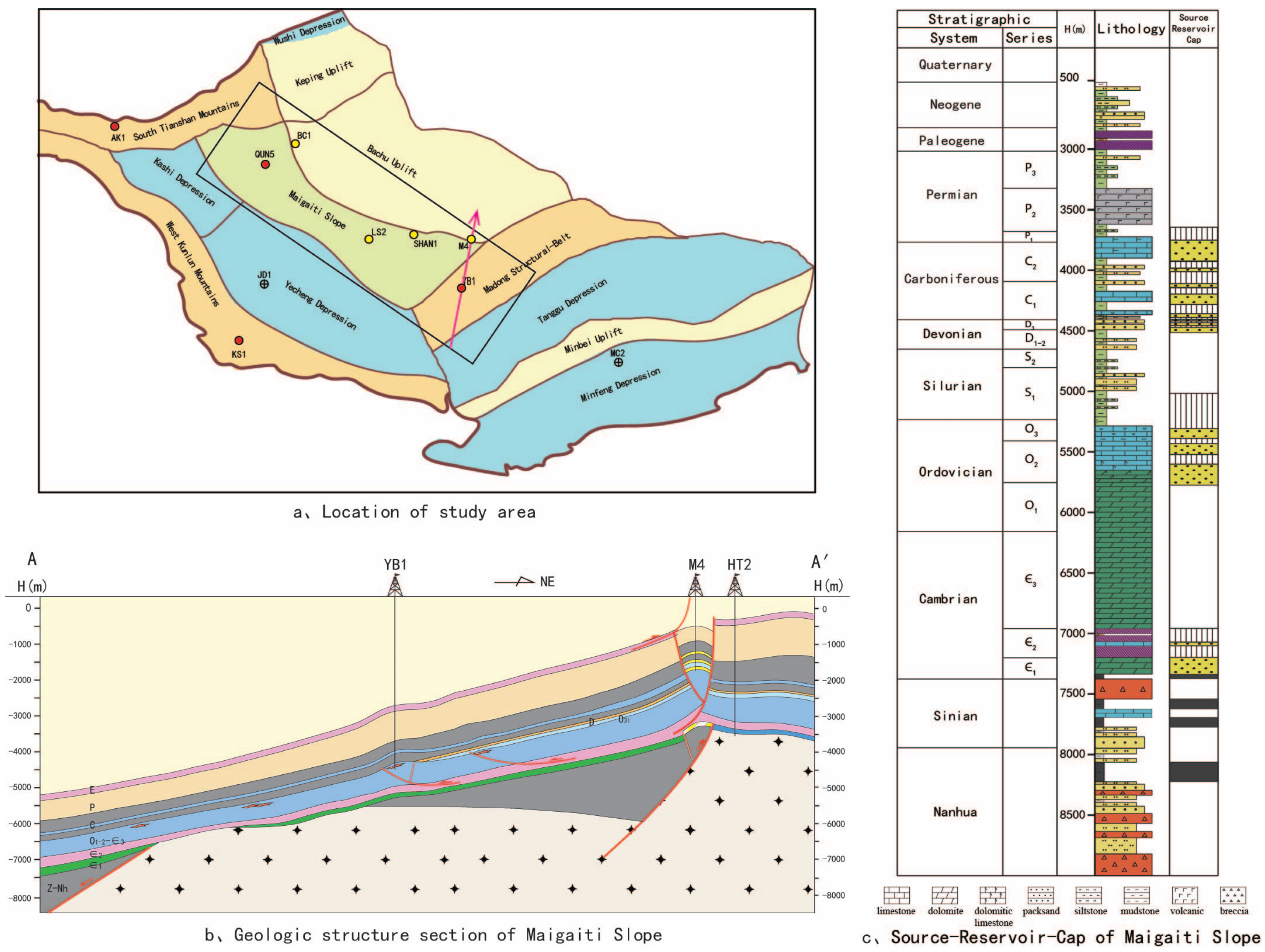
The Maigaiti Slope is located in the front of the Southwest Depression of the Tarim Basin, adjacent to the Xikeer structural belt in the north, connected to the Bachu Uplift by the Selibuya mazatake fault in the northeast, and bounded by the Kashi Depression in the west and Yecheng Depression in the southwest. It is a slope structure with rapid northeast tilting in the late Neogene. Its exploration area is about 40,000 square kilometers (
Figure 1). The Maigaiti Slope strikes from northwest to southeast. Influenced by multi-stage tectonic activities, the Maigaiti Slope has east–west segmentation in plane. From west to east, several fault structural belts formed, such as the Kuoshilake structural belt, Qunkuqiake structural belt, Selibuya structural belt, Luositage structural belt, Luonan-Niaoshan structural belt, and the Mazhatage structural belt.
The Maigaiti Slope inclines to the southwest, where deposited strata from PreCambrian to Neogene without Mesozoic, and Silurian and Devonian developed locally only. According to seismic and drilling data, the strata are thicker in the west than in the east. The thickness of the lower Paleozoic is about 4000 to 5200 m, and the thickness of the upper Paleozoic is about 900 to 2500 m. The Middle and Upper Ordovician, Silurian and Devonian were overlaid on the older weathering crust, and peaked from north to south under the control of paleo-uplift. For example, in the western Maxi area, the Silurian deposited on the weathering crust of the Ordovician Yingshan Formation, and in the eastern Manan area, the lower Carboniferous mudstone directly covered on the weathering crust of the Yingshan Formation. The Mesozoic strata were almost denudated due to the overall uplift in the Mesozoic. In the Cenozoic, overall tectonic subsidence and inversion developed, causing the tectonic tendency changes from northwest to southeast. Therefore, the Cenozoic was distributed along the whole slope area, but its thickness increased from north to south, varying from 2000 to 9000 m.
The history of oil and gas exploration on the Maigaiti Slope dates back to the 1960s. Through the petroleum exploration of several generations of geologists, a basic understanding has formed, such as multiple types of reservoirs, multiple series of strata containing oil and gas, and multi-layer vertical accumulation models. The Maigaiti Slope can be divided into over-salt and sub-salt exploration fields by the boundary of thick paste salt of the Middle Cambrian. The reservoir and cap assemblages of the Middle and Lower Cambrian developed in the sub-salt, and the favorable reservoirs of the Ordovician, Devonian, Carboniferous and Permian developed in the over-salt. The main source rocks of the Lower Cambrian—PreCambrian developed, and multi-stage strike faults communicated source rocks and reservoirs. This is an important channel for hydrocarbon migration, as well as adjustment.
3. Staged and Segmental Characteristics of Maigaiti Slope Strike-Slip Faults
3.1. Staging Characteristics of Strike-Slip Faults
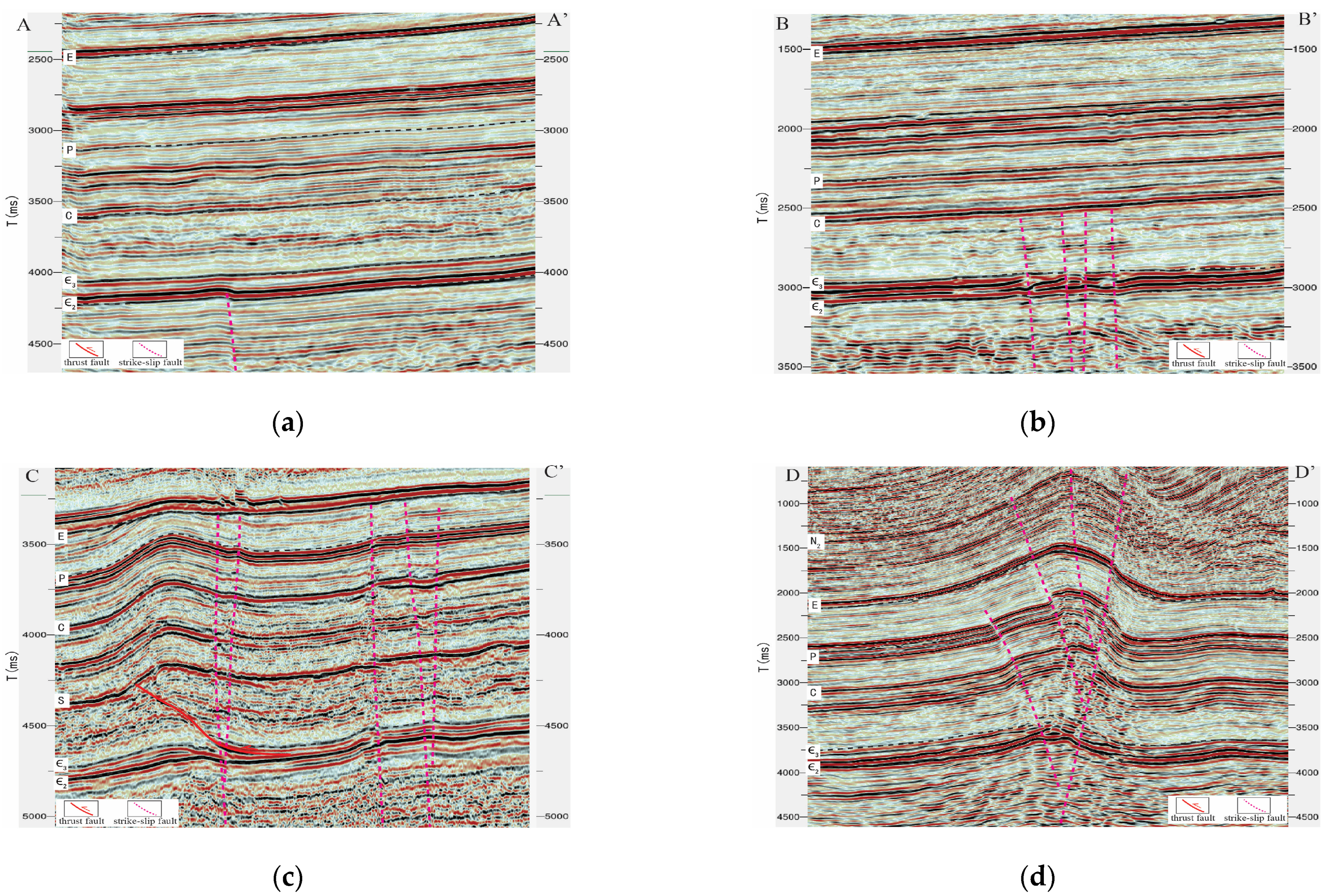
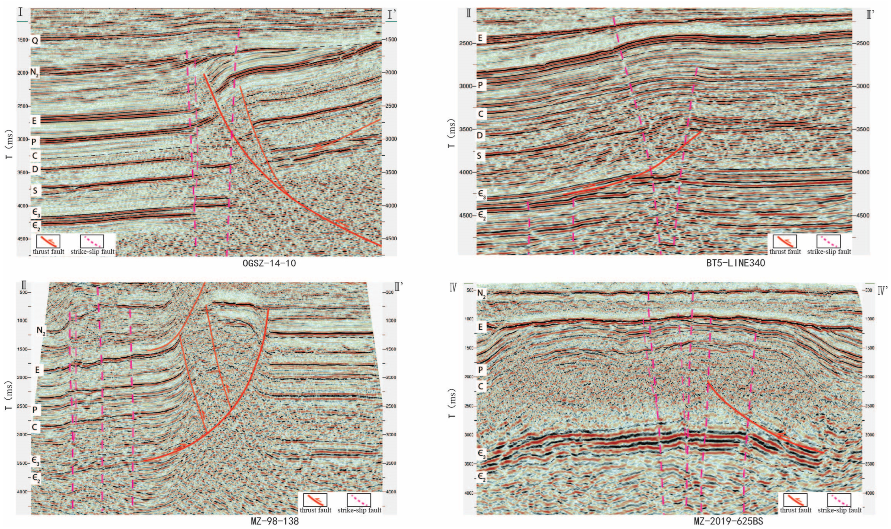
The stage characteristics of strike-slip faults of the Maigaiti Slope were studied by detailed seismic interpretation of the whole layer, and the tectonic evolution of the basin [
22,
23,
24]. The Maigaiti Slope strike-slip faults can be roughly divided into four stages: early Caledonian, late Caledonian, Hercynian, and Himalayan. Early Caledonian strike-slip fault: the longitudinal fault disappeared in the Middle Cambrian. It can be seen from the three-dimensional earthquake that this fault has a certain control on the deposition of the Middle Cambrian, and the Middle Cambrian shows certain synsedimentary characteristics (
Figure 2a); Late Caledonian strike-slip fault: the fault extends vertically to the top of Ordovician limestone, seismic facies phenomena such as “beading” and “flake reflection” of Ordovician carbonate rocks related to the strike-slip fault can be seen in the seismic section, which is direct evidence of the development of the strike-slip fault in this period (
Figure 2b); Hercynian strike-slip fault: the longitudinal upper fault to Carboniferous to Lower Permian disappeared, the seismic profile shows the characteristics of “flower structure”, Hercynian is Maigaiti Slope strike-slip fault mainly formed stage (
Figure 2c); Strike-slip faults in Himalayan period: this fault traverses the Paleogene system vertically, mostly to the Neogene, and partially to the Quaternary system (
Figure 2d).
3.2. Segmentation Characteristics of Strike-Slip Faults
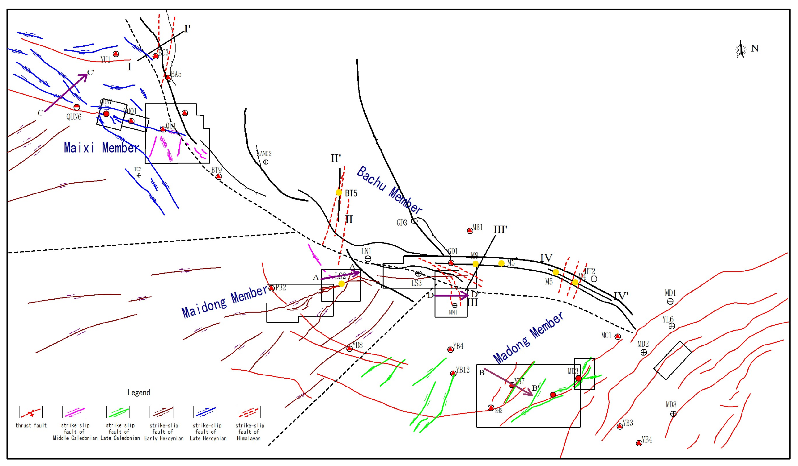
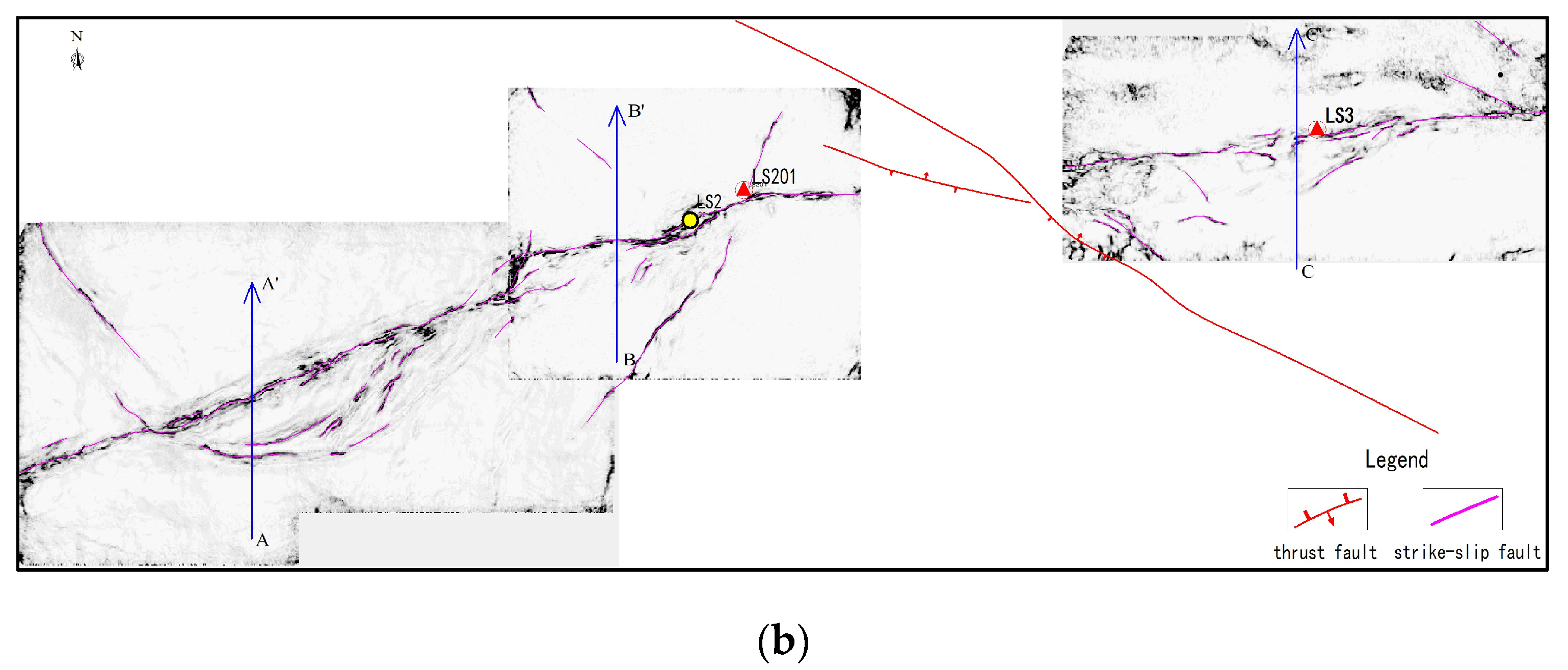
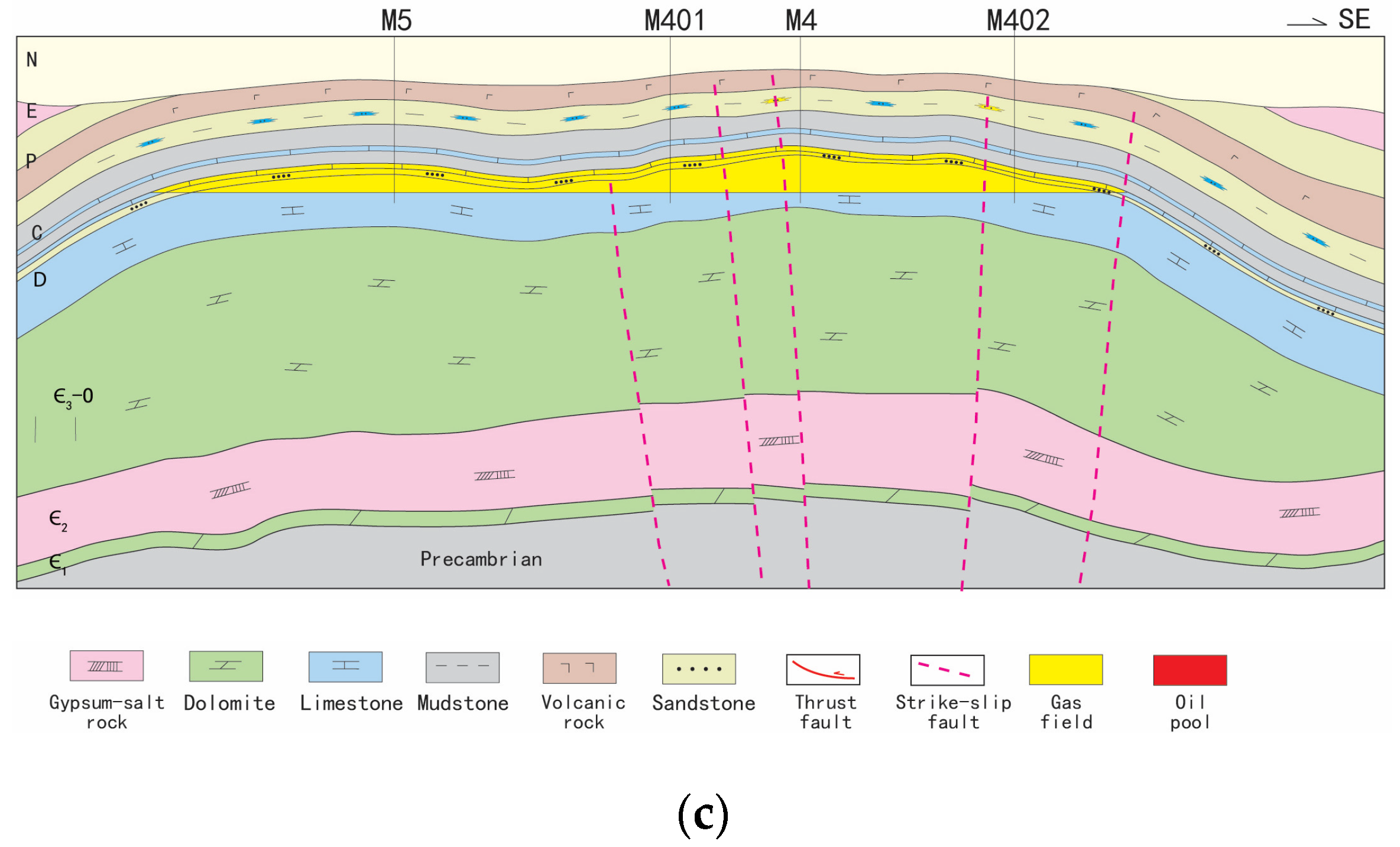
The development characteristics of thrust and strike-slip faults in the longitudinal section were described through full-layer seismic interpretation, the distribution characteristics of plane faults were described by 3D seismic coherence attribute analysis, and the fault characteristics of the Maigaiti Slope were understood in 2–3D seismic combination, and 3D vertical and horizontal. According to the research findings, two groups of strike-slip fault systems are developed in the main part of the Maigaiti Slope, which are NE and NW-trending. However, there are certain differences in fracture-formation period, fault strike, and tectonic style in different regions. Therefore, the study area can be divided into four zones: Maixi Member, Maidong Member, Madong Member, and Bachu Member (
Figure 3).
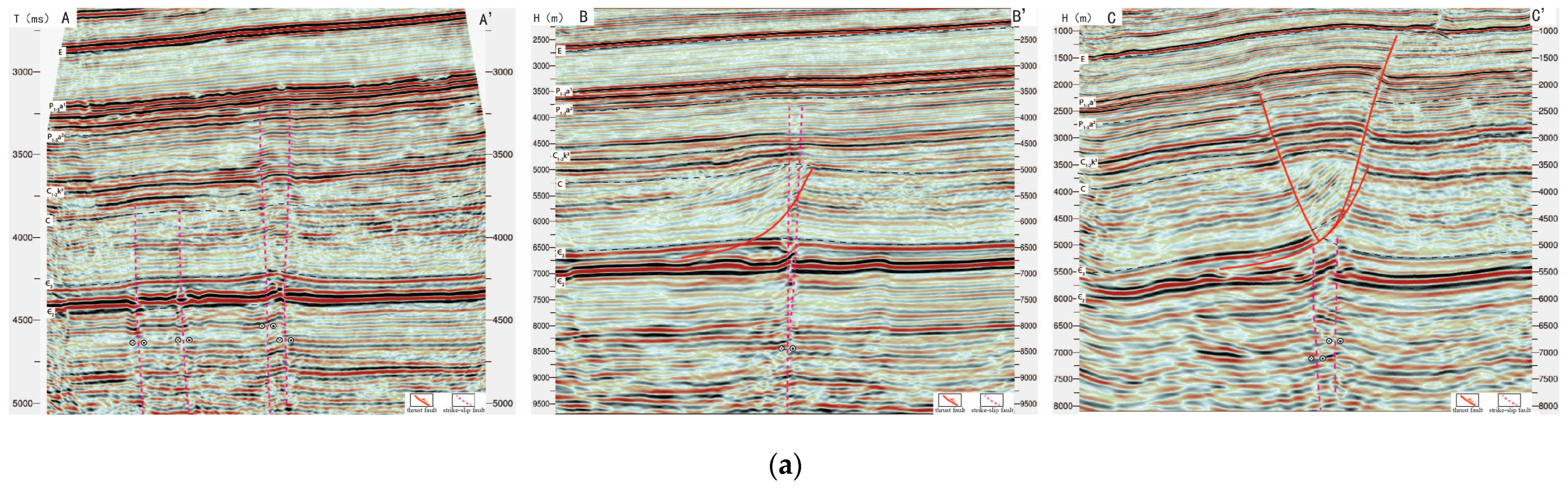
(1) The Maixi segment: From seismic coherence properties and seismic profile characteristics, it can be seen that two groups of strike-slip faults are mainly developed in this area: NW trending and NW trending, the strike-slip fault groups are longitudinally faulted upward to the Permian system, which are formed in the late Hercynian period. The characteristics of “flower structure” of these strike-slip faults can be seen clearly in the seismic section. Each group of strike-slip faults is spread in parallel. The two groups of faults intersect at a low Angle, and show an “X” shear relationship. The strike-slip fault system weakens from NW to SE, and exhibits dextral strike-slip characteristics, with a plane length of 600 km and disappearing southward in the area of Well BT7. In addition, NE and NW-trending strike-slip faults are locally developed in the southeast end. The strike-slip faults disappear in the Middle Cambrian paste rock profile; they were formed in the Middle Caledonian period. The strike-slip faults are short in plane length and have obvious features of being cut into wrong segments by late strike-slip faults (
Figure 4).
(2) The Maidong Segment: It can be clearly identified by the 3D seismic coherence attribute that this segment mainly develops NE-trending and a NE-trending early Hercynian dextral strike-slip fault system. The fault zone extends about 250 km in plane length and converges from west to east, showing the characteristics of “wide in the west and narrow in the east, strong in the west and weak in the east”. From the seismic profile, it can be seen that the strike-slip fault in the west reaches to the Permian igneous rock segment, the fault zone is 4–7 km wide, and the branch faults are developed. In the periphery of the LS2 Well area in the middle part, the strike-slip fault breaks to the top of the carboniferous system, and the fault zone is narrow—about 2–4 km—showing continuous linear distribution in plane. In the periphery of the eastern LS3 Well area, strike-slip faults extend to the Cambrian system; most of them disappear into the Middle Cambrian gypsum rock layer, showing discontinuous linear distribution characteristics in plane (
Figure 5).
(3) The Madong Segment: The late Caledonian salt-slip thrust fault is developed as a whole, and the NE-trending late Caledonian strike-slip fault is only developed in the southwest end. The fault zone has a short extension length of about 50 km and limited distribution, which is associated with the late Caledonian thrust fault (
Figure 3).
(4) The Bachu Segment: Himalayan strike-slip faults are mainly developed, distributed on the southern slope of circum-Bachu Uplift. The Selibuya fault-Tuohetage-Kangtakumu fault zone, Haimiluositage-Gudongshan fault zone, and Mazhatage fault zone are successively developed in the southern slope of Bachu Uplift from north to south [
25,
26]. The strike-slip faults are mainly developed between the fault zones, which are the adjustment faults between the fault zones. With the characteristics of dextral strike-slip faults, four concentrated development zones of strike-slip faults can be roughly identified (
Figure 3 and
Figure 6).
3.3. Genetic Mechanism of Strike-Slip Faults
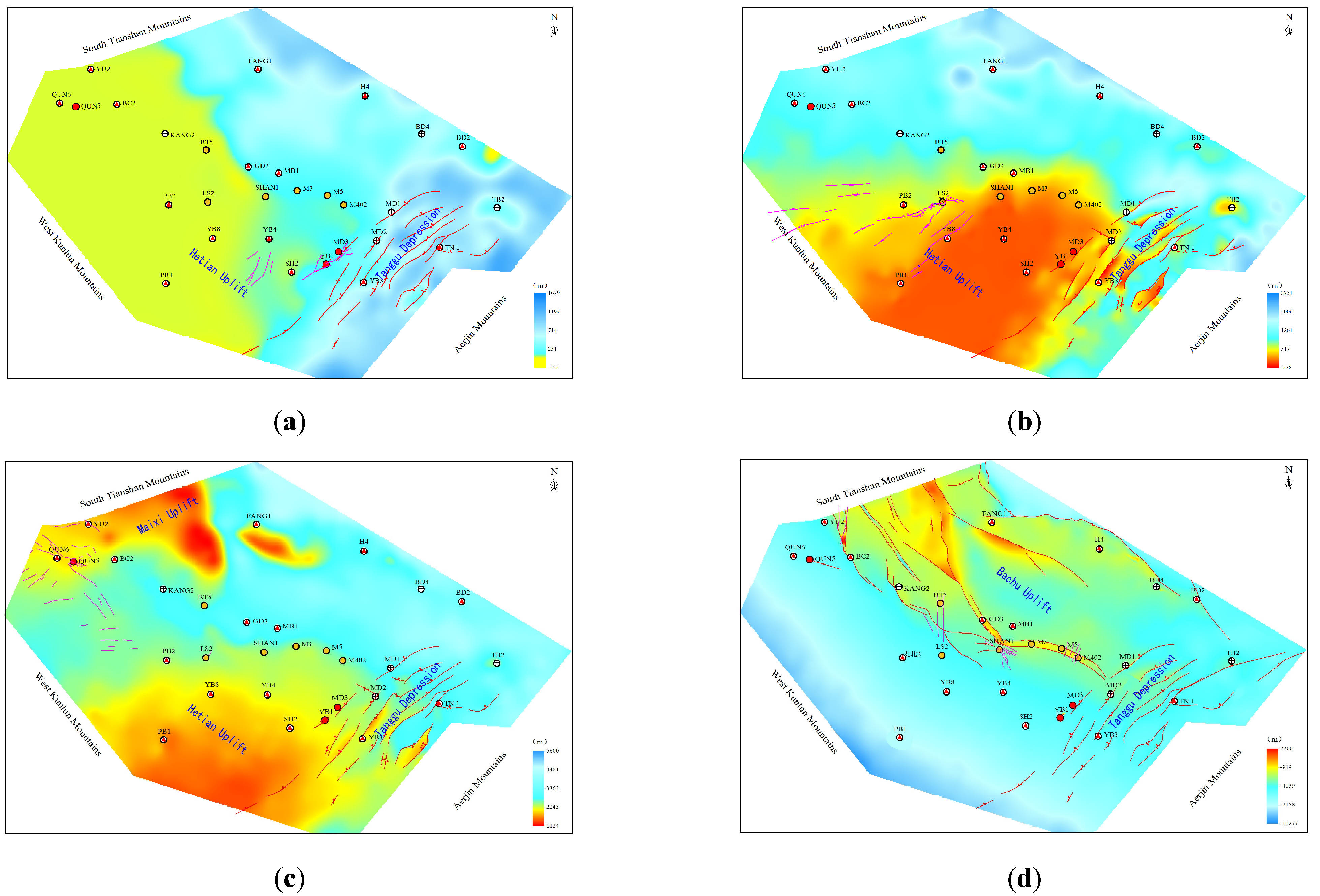
Due to the interaction of India, northern Tibet, and the Eurasia plate, the Maigaiti Slope in the Tarim Basin is held by several orogenic systems, including the South Tianshan Mountains, West Kunlun Mountains and Aerjin Mountains. Influenced by different period orogeny, the region’s tectonic stress field changes drastically, and the formation of the strike-slip fracture system is a comprehensive response to the different periods and the direction of tectonic movement. It is closely related to the formation and migration of the Hotan paleo-uplift (
Figure 7).
During the late Caledonian, under the influence of the compression stress transfer from south to north of the Aerjin orogenic belt, the Tanggu depression in the front of the orogenic belt formed a NE-trending multi-row thrust structure. Restricted by the Hetian paleo-uplift at the front, a NE-trending compression strike-slip component was formed between the Hetian paleo-uplift and the Tanggu Depression (
Figure 7a).
During the early Hercynian to Indosinian period, with the continuous uplift of the Hetian paleo-uplift, the distribution range of the paleo-uplift converged to the south and migrated to the northeast, forming the strike-slip fault system in the active margin of the north flank of the Hetian paleo-uplift. During the late Hercynian period, the distribution range and scale of the Hetian paleo-uplift remained basically unchanged. Under the action of the south Tianshan orogenic belt from north to south, Maixi paleo-uplift was formed, and the strike-slip fault system was formed in the active margin of the southwest wing of Maixi paleo-uplift (
Figure 7b,c).
The Himalayan Hetian paleo-uplift migrated north with strong uplift, and the Maixi paleo-uplift merged to form the early prototype of the Bachu uplift. As a result of differences in uplift, the Bachu uplift southern boundary faults show obvious differences in deformation [
27,
28], forming multiple fault zones (such as Selibuya-Tuohetage-Kangtakumu fault zone, Haimiluositage-Gudongshan fault zone, Mazhatage fault zone), between the fault zones, forming a series of NE-trending strike-slip fault systems of structure adjustment (
Figure 7d).
4. Control of Strike-Slip Faults on Hydrocarbon Accumulation
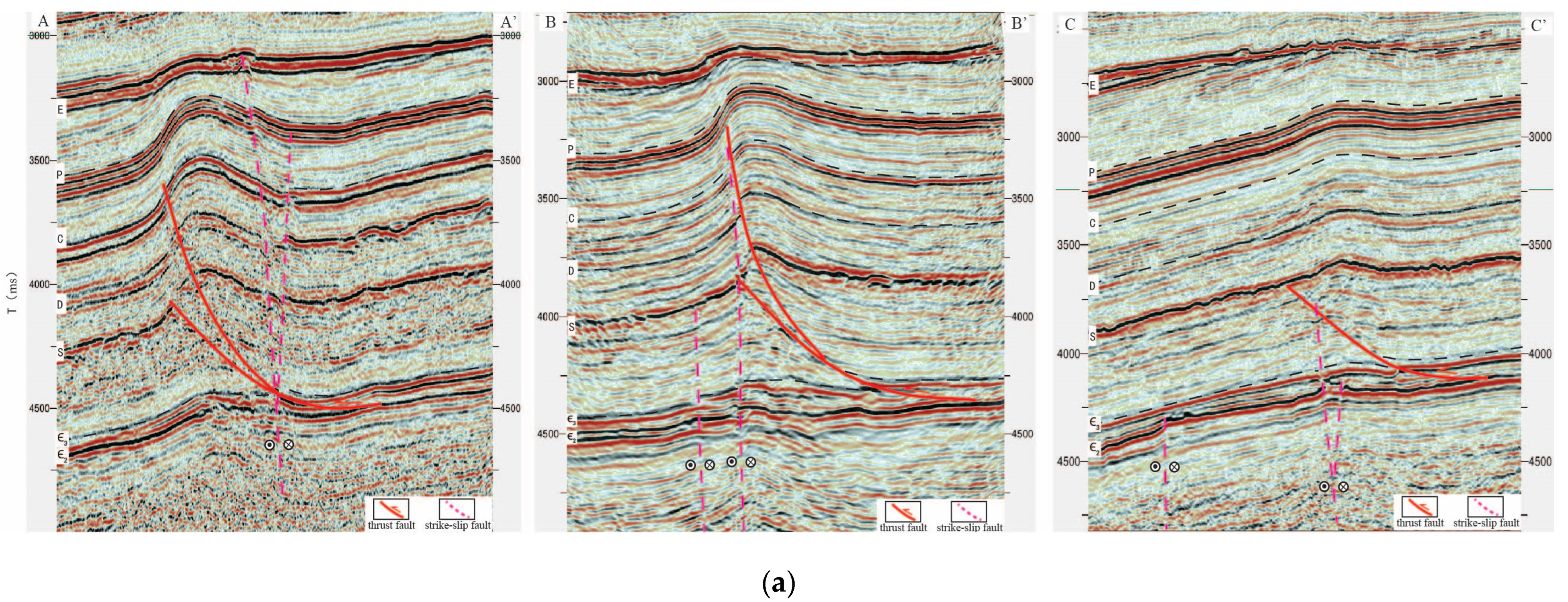
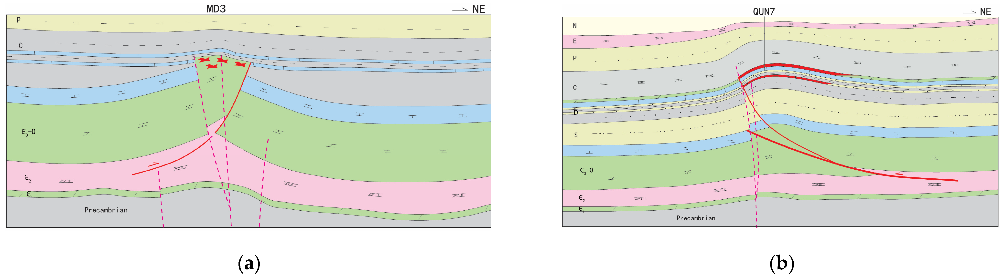
Strike-slip fault, as an important channel for hydrocarbon migration and accumulation, is the key factor controlling hydrocarbon reservoirs forming in the Maigaiti Slope. There are four strike-slip faults in the early Caledonian, late Caledonian, Hercynian, and Himalayan stages in the Maigaiti Slope. The spatial-temporal matching relationship between the active stages of strike-slip faults and the trap forming stage is the key to hydrocarbon accumulation, and determines the enrichment layers and hydrocarbon properties of the reservoirs in the Maigaiti Slope (
Figure 8).
The early Caledonian strike-slip faults did not break through the Middle Cambrian gypsolith and salt, and the oil and gas were preserved under the Cambrian gypsolith and salt. The strike-slip faults in the early Caledonian became the necessary conditions for the continuous accumulation of oil and gas in the dolomite reservoirs of the Lower Cambrian as a pathway system close to the source rocks.
The late Caledonian strike-slip fault is well matched with the Ordovician thrust buried-hill trap formation stage, which is the key for hydrocarbon accumulation in the Ordovician carbonate fracture-cavity reservoir. In this period, the deep source Cambrian rocks are of lower maturity and buried less deeply. In addition, the buried depth of the Middle Cambrian gypsum rock (about 2300 m) is brittle [
29]; the oil and gas easily break through the thick Middle Cambrian gypsum rock and accumulate in the Ordovician carbonate reservoir. The crude oil properties are of medium-heavy oil, such as in Yubei 1-Madong 3 reservoir, where the average crude oil density is 0.918–0.937 g/cm
3. There is a small amount of mature associated gas (
Figure 8a).
Hercynian strike-slip faults and structural traps formed in this period constituted a superior trap-migration-preservation spatial-temporal matching relationship, forming the characteristics of Ordovician–Carboniferous multi-purpose strata containing oil and gas, and the strike-slip faults directly determine the layers of oil-gas accumulation. In the Cambrian system, during the period where hydrocarbon source rocks were buried deep, the highly mature overall stage of oil and gas, by strike-slip fault in the Ordovician, Devonian, and Carboniferous systems gathered in many sets of reservoirs, and presents multi compound hydrocarbon accumulation characteristics; the crude oil is characterized by light oil, such as the Bashituopu oil pool, oil density of about 0.797 to 0.820 g/cm
3, accompanied by a certain amount of gas (
Figure 8b).
The strike-slip faults of the Himalayan period determine the characteristics of multi-purpose gas reservoirs in this study area. During this period, the buried depth of the deep source rocks of the Cambrian was more than 6500 m, and it was in the over-mature stage of gas generation. Natural gas accumulated in the structural traps of the Ordovician, Devonian, Carboniferous and Permian through strike-slip faults (
Figure 8c), and showed the characteristics of dry gas, forming the Hetianhe and Yasongdi gas fields.
5. Discussion
The exploration of oil and gas in the Maigaiti Slope started some time ago and has taken a long time. It was considered by the older geologists as one of the four most important favorable exploration fields in the Tarim Basin at the stage of regional oil check. Up to now, nine small and medium-sized oil and gas reservoirs have been discovered in the Maigaiti Slope, mainly distributed on the edge of the paleo-uplift. However, exploration work has not been carried out on a large scale. The oil and gas in the Maigaiti Slope is all derived from Cambrian source rocks; therefore, resources are abundant, but hardly proved. As a result, the Maigaiti Slope is still one of the most important exploration and research areas in the Tarim Basin.
According to current understanding of tectonic stratification and the allocation of hydrocarbon accumulation factors, three oil and gas accumulation assemblages developed in the Maigaiti Slope: Carboniferous–Devonian, Ordovician, and Cambrian sub-salt. The multi-layer vertical accumulation model also developed, with strike-slip and thrust faults forming at different times as the key factors for hydrocarbon accumulation.
Donghe sandstone, Carboniferous bioclastic limestone, and Carboniferous high-energy beach carbonate rocks developed in the Upper Carboniferous and Devonian. The Upper combination is mainly explored for stratigraphic lithologic oil and gas reservoirs, but its single layer is thin, and the reservoir varies rapidly laterally. The existing seismic data are mainly two-dimensional seismic, with a limited area of three-dimensional seismic. It is, therefore, difficult to carry out effective reservoir characterization. Since the Donghe sandstone of Well No. 7 obtained industrial oil flow in 2007, it is still in the preparatory research stage, without new exploration in the Upper combination over the past 15 years.
There are three types of reservoirs in the Middle combination: Ordovician carbonate buried-hill, fault-controlled karst body, and karst slope weathering crust. On the basis of the current 2D and 3D seismic data, it is difficult to make new progress in the search for and implementation of buried-hill traps. Furthermore, it is also very difficult to depict the palaeogeomorphology because of the limited accuracy of weathering crust traps. Therefore, current exploration research’s focus on fault-controlled karst reservoirs; fully absorbing the successful exploration experience of fault-controlled karst reservoirs in the Fuman area in the past five years; depict the Tongyuan strike-slip fault with the idea that “there must be faults”. To carry out the fault-controlled karst reservoir prediction on the Maigaiti Slope, we firstly depict source rocks-connected strike-slip faults based on the understanding that where there is a string of beads, there are faults.
The Lower combination, which is Cambrian sub-salt, is located in the favorable facies zone of the subtidal grain beach, developing favorable reservoir space such as intergranular pore and intergranular solution pore of dolomite, which form a good reservoir-cap assemblage with the gypsum salt of the Middle Cambrian. However, drilling explorations in recent years all failed because strong reflection of Permian igneous rock and Cambrian gypsum rock produces multiple waves in the deep area, which can greatly mislead the interpretation of the Cambrian bottom boundary and the characterization of source rocks. Therefore, at present, the Lower combination is at a key stage of processing seismic data to eliminate multiple waves.
At present, it is considered that the dark mudstone of the Lower Cambrian Yuertusi Formation is the most important source rock in the Maigaiti Slope. Based on the latest seismic and drilling data, the Cambrian source rocks in the Maigaiti Slope are re-recognized. According to the analysis of paleostructure and paleofault, the source rocks in the Maigaiti Slope are mainly developed in the lower slope, and the source rocks in the bastion zone are thinning or missing. According to the existing data, three sub-pools developed in the Maigaiti Slope at the time when Yuertusi Formation source rock was deposited. The source rocks are about 0 to 40 m thick in the Maixi and Xikeer sub-pools, and about 0 to 20 m thick in the Manan sub-pool, covering a whole area of 26,000 square kilometers.
In conclusion, the characterization of source rocks, and the study of hydrocarbon accumulation rules are the two keys to exploration of, and research in, the Maigaiti Slope. The oil and gas accumulation in the Maigaiti Slope can be characterized by “multi-layer accumulation vertically, but short-distance extension horizontally”. Strike-slip faults with multiple stages, different grades and various tendencies connecting source rocks and favorable traps are the most important secondary migration channels for oil and gas. Strike-slip faults control the distribution of oil and gas in plane, and the accumulation layer of oil and gas in vertical. In the next stage of oil and gas exploration, we should take the characterization of the strike-slip fault as the breakthrough point, strengthen the processing and interpretation of seismic data, use the new seismic and new drilling data to continuously promote the characterization of strike-slip faults, and explore the favorable exploration target of the effective allocation of hydrocarbon, reservoir, fault, and cap rock in the slope area.
6. Conclusions
(1) The fault-formation period, fault strike, and tectonic style are different in different areas of the Maigaiti Slope, which can be divided into four sections: Maixi Segment, Maidong Segment, Madong Segment, and Bachu Segment. The Maixi Segment mainly develops the NW-trending late Hercynian strike-slip fault system, the Maidong Segment mainly develops the NW-trending early Hercynian strike-slip fault system, the Maidong Segment mainly develops the NW-trending late Caledonian strike-slip fault system, and the Bachu Segment mainly develops the Himalayan strike-slip fault system.
(2) The tectonic stress field of the Maigaiti Slope varies greatly under the influence of orogenic movement in different periods. The formation of a strike-slip fault system in the Maigaiti Slope is a comprehensive response to multi-period and multi-direction tectonic movement, which is closely related to the formation and migration of Hetian paleo-uplift and other tectonic events.
(3) The coupling relationship between the active period of strike-slip faults and the trap-forming period is the key to hydrocarbon accumulation in the Carboniferous–Ordovician, which determines the petroleum properties and enrichment horizon of the Cambrian post-salt system. These are: medium-heavy oil in the Caledonian period, light oil in the Indosinian period, and dry gas in the Himalayan period.


