Article

A Software for RFI Analysis of Radio Environment around Radio Telescope

1
Research Center for Intelligent Computing Platforms, Zhejiang Laboratory, Hangzhou 311100, China
2
National Astronomical Observatories of China, Chinese Academy of Sciences, Beijing 100101, China
3
National Key Laboratory of Radio Astronomy and Technology, Beijing 100101, China
4
Hebei Key Laboratory of Radio Astronomy Technology, Hebei 050081, China
5
School of Microelectronics, Tianjin University, Tianjin 300072, China
6
Qingdao Institute for Ocean Technology, Tianjin University, Qingdao 266200, China
*
Authors to whom correspondence should be addressed.
Universe 2023, 9(6), 277; https://doi.org/10.3390/universe9060277
Submission received: 18 April 2023 / Revised: 18 May 2023 / Accepted: 19 May 2023 / Published: 8 June 2023
(This article belongs to the Special Issue New Discoveries in Astronomical Data)

Abstract

:
Radio astronomy uses radio telescopes to detect very faint emissions from celestial objects. However, human-made radio frequency interference (RFI) is currently a common problem faced by most terrestrial radio telescopes, and it is getting worse with the development of the economy and technology. Therefore, it is essential to monitor and evaluate interference during the planning, construction, and operation stages of the radio telescope and protect the quiet radio environment around the radio astronomical site. In this paper, we present a software for an RFI analysis of the radio environment around the telescope. In this software, information has been collected, including the location of the site; the technical specifications, such as aperture and the frequency range of the radio telescopes; and the terrain around the site. The software and its modules are composed of telescope, geographic, and meteorological databases, and analysis modules of terrestrial and space-based RFI. Combined with the propagation characteristics of radio waves, we can analyze and evaluate RFI on the ground and in space around the radio telescope. The feasibility of the software has been proved by the experimental implementation of the propagation properties and RFI source estimation. With this software, efficient technical support can be expected for protecting the radio environment around the telescope, as well as improving site selection for planned radio astronomical facilities.

1. Introduction

Radio astronomers study the Universe by detecting and analyzing radio waves emitted by celestial objects, such as stars, galaxies, and black holes. These signals are transmitted over long distances and require sensitive instruments to detect them. However, RFI from human-made sources, such as mobile phones, TV broadcasts, satellites, and other communication systems, can cause unwanted noise and signal interference, making it difficult to distinguish between the cosmic signals and the RFI. This can seriously degrade the quality of astronomical data, limit the sensitivity of observations, and even render some observations useless.
Therefore, radio astronomers take special care to position their telescopes in remote locations away from human-made RFI sources and use various RFI mitigation techniques to filter out or correct for interference. Setting up the Radio Quiet Zone (RQZ) is the most effective way to protect the electromagnetic environment from the terrestrial RFI [1]. Meanwhile, some large radio telescope facilities have established monitoring systems for terrestrial RFI and developed the satellite RFI databases and prediction systems to prevent interference from satellites [2,3,4].
In addition, astronomers also need to use some statistical algorithms or manual editing to further mitigate and flag the RFI-contaminated data [5,6,7]. With new technologies such as multi-beam and phased array feed receivers, the amount of astronomical data is increasing dramatically, and avoiding RFI or providing efficient flagging will be necessary for next-generation radio facilities. Some machine-learning-based RFI recognition methods have been applied and developed to reduce human intervention and increase accuracy [8,9,10]. This type of supervised learning method requires a large amount of training data to obtain accurate results and is mostly in the experimental stage.
In the field of RFI monitoring and estimation, Ref. [11] provided a scientific basis for the scientific site selection and radio astronomy protection operations through relevant electromagnetic environment tests. Ref. [12] validated the applicability of the ITU-R model in the Karst Region of Guizhou to support the analysis and assessment of the RFI around FAST. Ref. [13] focused on an intelligent monitoring and positioning system to reduce radio frequency interference (RFI) based on monitoring, identifying, and positioning RFI sources. Ref. [14] conducted electromagnetic compatibility studies on FAST, evaluated the RFI impact on mobile communication stations by conducting RFI tests, and proposed a permanent communication station to reduce RFI. Ref. [15] analyzed the radiation characteristics of the public communication stations around FAST and proposed interference avoidance and frequency coordination strategies based on cognitive theory.
In recent years, radio astronomical facilities in China have been rapidly developed. The Five-hundred-meter Aperture Spherical radio Telescope (FAST) has commenced astronomical observation since 2020, the 65-m radio telescope of Shanghai Astronomical Observatory (TM65) has obtained several extraordinary outcomes, and the Qitai 110m Radio Telescope (QTT) in Xinjiang is under construction [16,17,18,19]. Meanwhile, the development of the economy and electronic infrastructure near the telescope site has made the electromagnetic environment complex. Wang et al. studied the radio signal’s fading characteristics in the Karst landscape environment and analyzed the radiation characteristics of the public communication stations around FAST RQZ [15,20]. In order to manage the surrounding electromagnetic environment more efficiently and balance the requirements of science and economics during the site selection and in the construction and operation phases of the radio telescope, we need to analyze and estimate RFI sources and protect the radio environment around the site.
In this paper, we describe an RFI analysis software that can estimate single or multiple RFI sources on the ground or in space around the radio telescope. Section 2 introduces the software and its modules, including the telescope, geographic, and meteorological database, and the analysis modules of terrestrial RFI and RFI in space. Section 3 presents the experimental implementation of the propagation properties and RFI source estimation. Section 4 gives a conclusion.

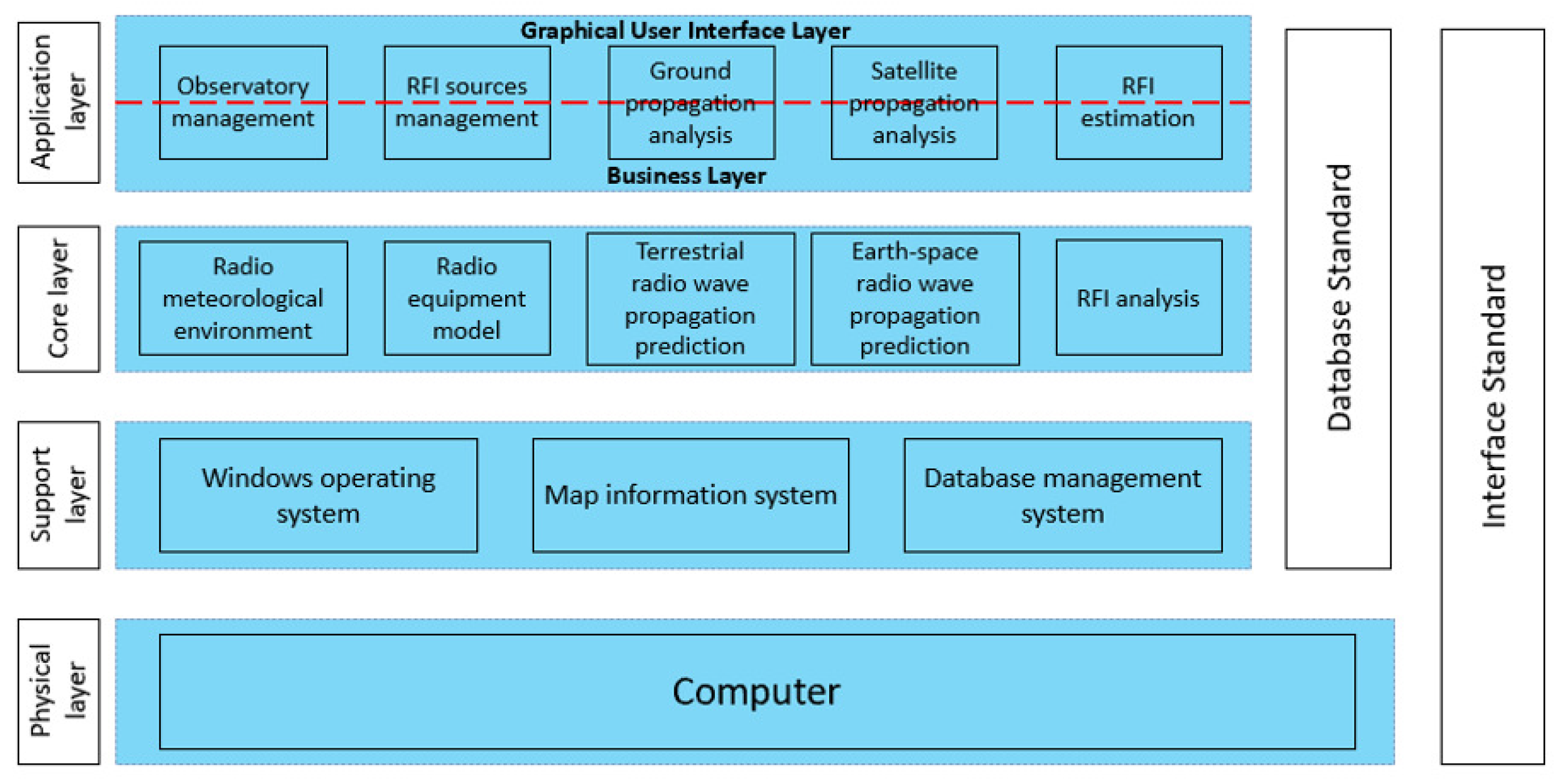
2. The RFI Analysis Software of Radio Environment around the Radio Telescope

This section introduces the RFI analysis software of the radio environment around the telescope. It is able to calculate the propagation loss based on the location of the RFI source and receiver, and it can further calculate the field strength and power at the receiver by combining the parameters of the RFI source and receiver. With this information, we can better manage the radio equipment or select the frequency range for observation in the site selection and operation phases of the telescope.
The schematic diagram is shown in Figure 1. It contains the database part and the functional part. The observatory database maintains the location of the site and the technical parameters of each telescope. The geographic and meteorological database gives the Digital Elevation Model (DEM) and radio meteorological environmental data. The RFI sources database offers information on the location of stationary RFI sources, the orbits of sources in space, and their operating parameters. The RFI analysis module provides terrestrial and space-based RFI analysis functions and radio wave propagation characteristics analysis for single or multiple RFI sources.
The software is developed on the Visual Studio platform using the C++ development language. It provides a friendly human–machine interface, keeping the interface simple and highlighting the system’s main functions. The user interface is divided into two main parts: the menu bar and the map area, where the menu bar provides shortcut buttons for all functions of the software, and the map area carries out station marking and effective display. The software interface is designed in a simple style and can be operated in a guided manner according to the user’s functional requirements.
Figure 2 shows the specific architecture of the software, which is designed in a layered approach, with four layers, including the application layer, the core layer, the support layer, and the physical layer.
The application layer is at the top of the architecture and consists of the graphical user interface layer and the business layer. The graphical user interface layer is responsible for receiving various parameter configuration commands from users and providing a consistent access interface for users, as shown in Figure 3. The business layer provides reusable business function modules, and the implementation of this layer and the graphical user interface layer results in a message-driven mechanism to communicate through a custom set of messages and exchange data information through memory. The functional modules of the application layer mainly include astronomical observatory management, RFI source management, terrestrial point-to-point/area propagation characteristics analysis, satellite point-to-point/area propagation characteristics analysis, etc.
The core layer mainly provides the underlying methods for each functional module of the business layer, including radio meteorological environment modeling, radio equipment modeling, terrestrial radio wave propagation prediction, Earth–Space radio wave propagation prediction, and RFI analysis. This layer provides various kinds of data and analysis results for each functional module. The interaction with the business layer adopts the API interface method, which provides a unified access interface for users and communicates with the upper layer through the interface function.
The support layer provides the required basic service environment for the upper layer, including the Windows operating system, map information system, and database management system. The operating system provides process services, thread services, interface units, etc. The map information system provides the geographic information required by the software. The database management system realizes the storage and management of antenna, equipment data, and radio wave propagation environment data.

2.1. Databases

The radio observatory database has a hierarchical design, where one observatory may have multiple telescope systems, and one telescope system may also have multiple antennas. It contains the name, the longitude and latitude of the observatory site, and the equipment parameters, including receiving frequency range, aperture, gain, beam pattern, and polarization. Users can add, delete, modify, and query observatory sites, telescope systems, and antenna equipment.
The geographic database provides the 3 arc-sec accuracy DEM with a longitude range from 70 E to 135 E and a latitude range from 10 N to 55 N. A DEM is a 3D computer graphics representation of elevation data to represent terrain or overlaying objects, commonly of a planet, moon, or asteroid. DEMs are used often in geographic information systems and are the most common basis for digitally produced relief maps. The geographic data will be loaded and used to construct the transmission loss model between the RFI transmitter and the receiver.
The meteorological database consists of a ground dielectric constant, conductivity, atmospheric refractive index and gradient, atmospheric temperature, atmospheric humidity, atmospheric pressure, etc. The ground electrical parameters include ground conductivity and dielectric constant, which are determined by measuring the ground wave propagation field strength and time delay from the transmitting source, and then using the ground wave propagation characteristics for inversion. The atmosphere parameters, such as pressure and temperature, are obtained by analyzing meteorological data from 752 terrestrial meteorological stations in China, 120 space-based stations, and more than 600 terrestrial stations in the neighboring areas of China for the past 20 years. The meteorological data required for calculation are mainly selected from the annual statistical data of the ITU, and the parameters are shown in Table 1. Combined with parameters such as the location of the proposed link, antenna height, and percentage time, our software predicts the basic transmission loss not exceeded for a given percentage of an average year based on the radio meteorological data.
The RFI sources database records the terrestrial and space-based RFI sources. Terrestrial RFI data offer the location, frequency range, power, and main lobe angle. Satellite RFI data offer the orbit calculated by the Two-Line Elements (TLE), the antenna beam pattern, the frequency range, and the power. When performing RFI analysis, users can manually add new RFI sources or select RFI sources from the database.

2.2. RFI Analysis Module

We construct the RFI analysis module with these databases to analyze the propagation characteristics and interference situations for different RFI sources. The RFI analysis module supports the analysis of a single RFI source for a single receiver or an area, which can be used to evaluate additional electronics around the telescopes and provide a basis for site selection, respectively. Moreover, the analysis of RFI sources can be terrestrially fixed or satellite services, as shown in Table 2.
The terrestrial model facilitates the prediction of propagation characteristics within the troposphere, spanning a frequency range from 30 MHz to 50 GHz. This model considers the main transmission mechanisms within the troposphere, including propagation close to the surface of the Earth, anomalous propagation due to stratified atmosphere, troposcatter propagation, and propagation via sporadic-E reflection. Utilizing numerical analysis techniques for synthesis, the model enables the prediction of transmission loss [25,31]. A practical propagation prediction model will then be derived by further combining domestic experimental data and analysis results.
Compared to free-space propagation, several propagation effects may require consideration when calculating the propagation loss for Earth–space paths: tropospheric effects (including gaseous absorption, and attenuation and depolarization by rain and other hydrometeors), ionospheric effects (such as scintillation and Faraday rotation), and local environmental effects (including attenuation by buildings and vegetation). Moreover, the prediction methods for Earth–space telecommunication systems vary depending on the specific service involved, including broadcasting-satellite systems [27], maritime mobile systems [28], land mobile systems [29], and aeronautical mobile systems [30]. In the case of space-to-Earth paths for broadcasting systems, the propagation attenuation factor A(f) is calculated by the formula, and the unit is dB [26]:
A = A bs ( f ) + A sc ( p , f ) + A gas ( f ) + A st 2 ( p , f ) + A rain ( p , f ) + A cloud ( p , f ) 2
A bs is the antenna attenuation factor, A sc is the ionospheric atmospheric attenuation, A gas is the atmospheric gases attenuation, A st is the troposphere scintillation attenuation, A rain and A cloud are the attenuation factors of rain and cloud, respectively, f is the frequency, and p stands for the time percentage of each parameter.
In practice, the software will combine models based on the service type and frequency range, RFI source location, and electromagnetic wave propagation mode to calculate the propagation loss and field intensity. The next section gives some experimental RFI analysis for terrestrial and satellite RFI sources.

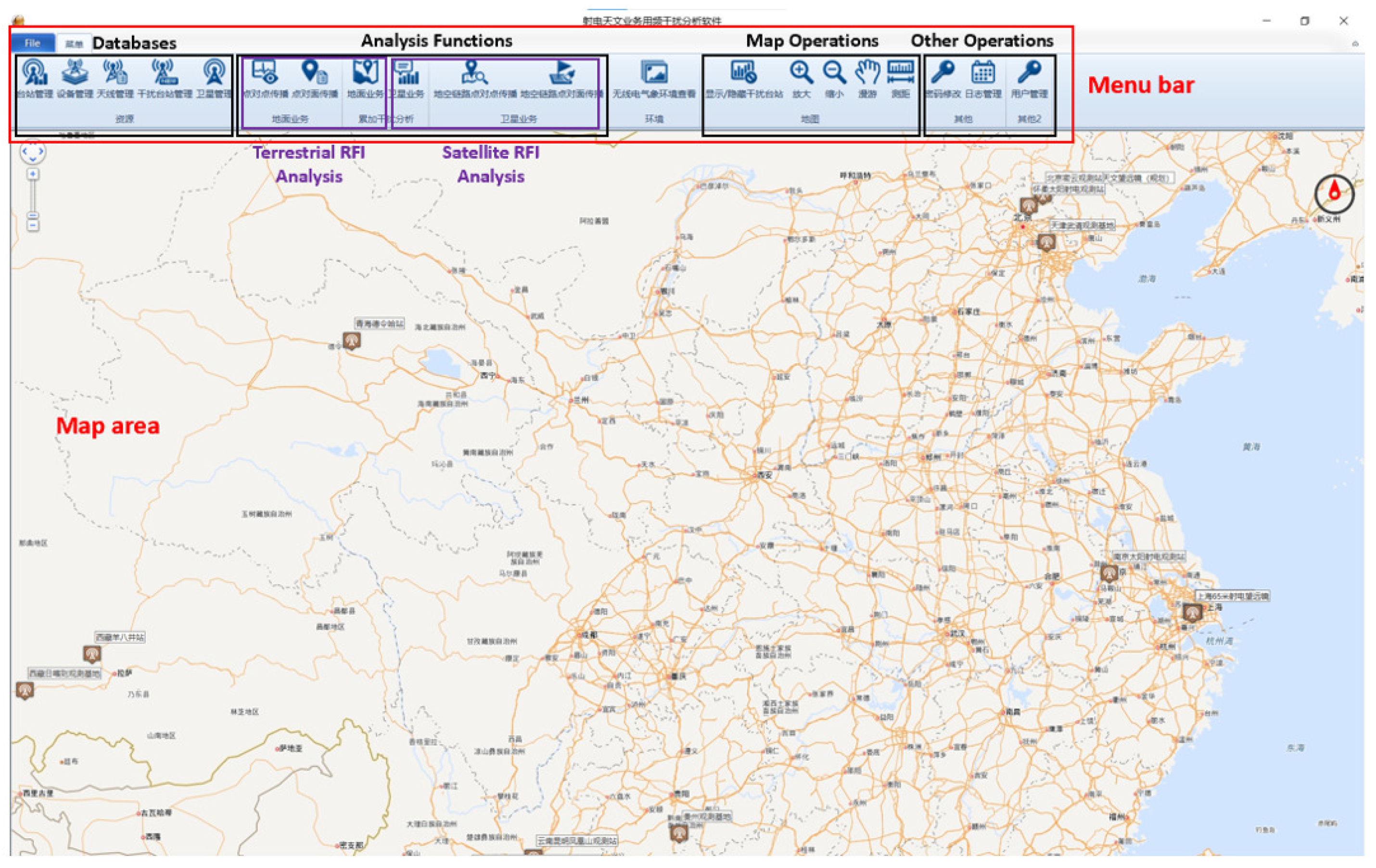
3. Experimental Implementation of the RFI Analysis Software

In this section, we present the experimental implementation of the software for propagation analysis and RFI estimation. Both the terrestrial and satellite RFI parts include the point-to-point and point-to-area functions. The point-to-point analysis is used to guide the installation and application of radio transmitters. The emission power of the equipment is derived from the measurement in the microwave darkroom, then the measurement results are loaded into the software to obtain the interference level in different locations. The point-to-area analysis is used for radio telescope site selection. It is able to calculate the distribution of the interference level of an existing RFI source to an area. Thus, the part with the lowest interference intensity is selected as the alternative site.

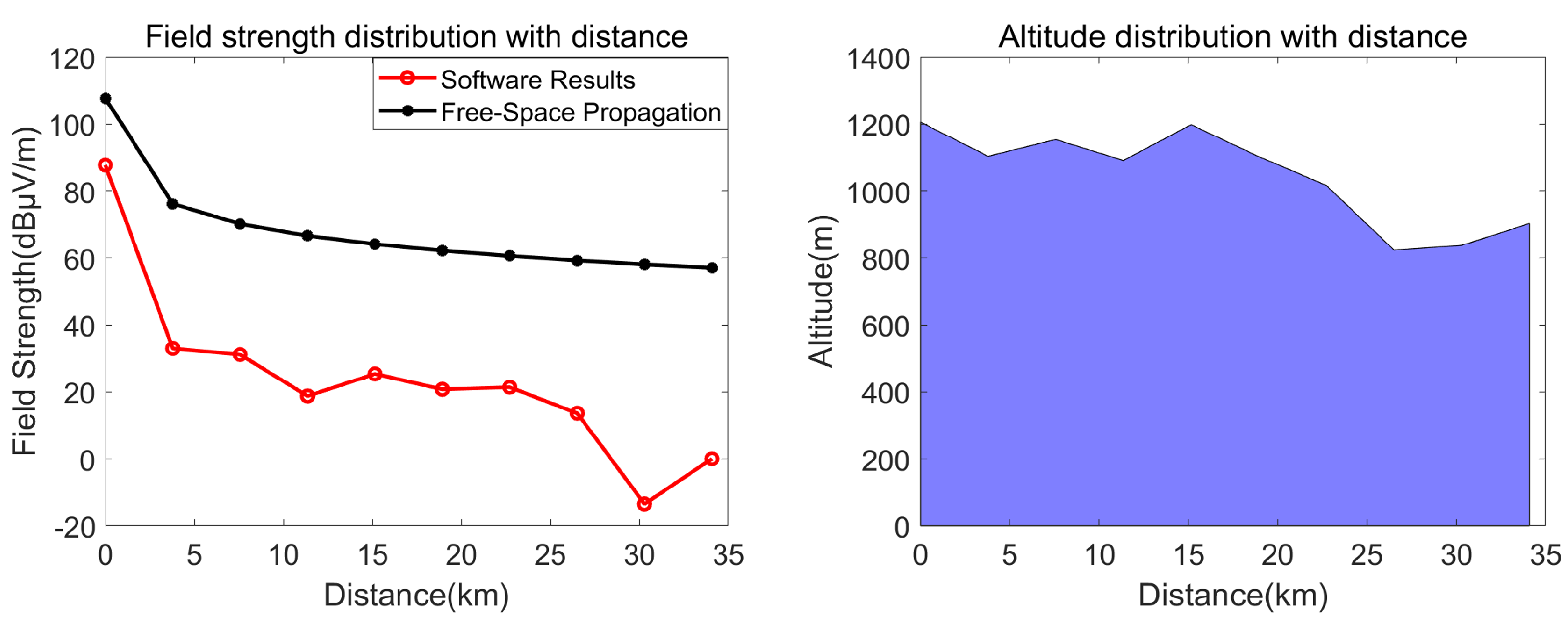
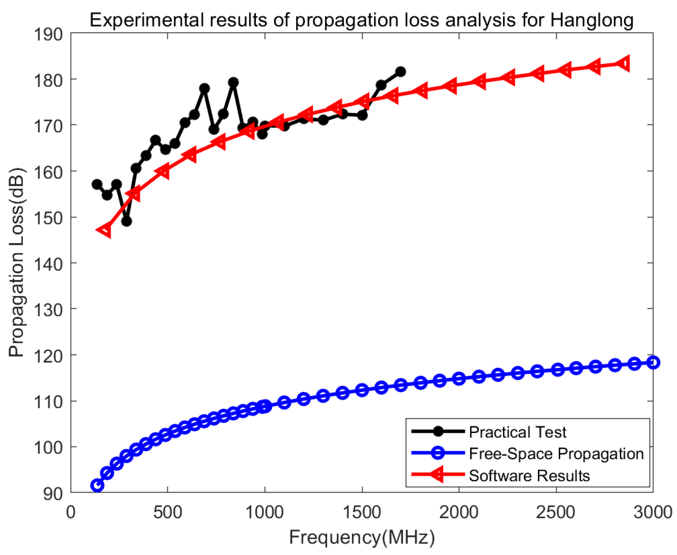
3.1. Terrestrial RFI Analysis

The characteristics analysis of the point-to-point radio wave propagation needs to set the transmitting and receiving point information: the user can choose from the database or add new sites, equipment, and antennas. The input information includes the site location, transmitting equipment operating frequency, power, antenna main lobe azimuth and elevation angle, receiving equipment name, sensitivity, and antenna main lobe azimuth and elevation angle. The radio meteorological environment around the transmitting and receiving points is also obtained from the database, and the results are calculated using the algorithm model.
For multiple-RFI-sources analysis, we integrate the received power over a time period of T. The power received from an interferer during observation can be expressed as follows:
I = 1 N i = 1 N P t ( i ) · G t ( i ) · G r ( i ) L p ( i )
where I is the interference power in the reference bandwidth at the receiver input averaged over the observation period T, N is the number of samples in the integration time T, P t ( i ) is the transmitting power level in the radio astronomy service bandwidth at the input to the antenna, G t ( i ) is the gain of the transmitting antenna in the direction of the radio astronomy antenna, G r ( i ) is the gain of the radio astronomy antenna in the direction of the transmitter, and L p ( i ) is the propagation loss at instant i.
Table 3 and Figure 4 show the computing results of the point-to-point propagation characteristics analysis. The example uses a communication station as the RFI source, which operates at 870 MHz and is located at ( 106 37 4.0005   E , 25 37 45.010   N ). The left part shows the plot of the analytical results: the variation in field strength and topography versus distance from the transmitter. The right table gives the corresponding computing results. Compared with the free-space propagation loss, our algorithm further takes into account the terrain and atmosphere, and the calculated field strength is lower and more in line with the actual situation.
The characteristics analysis of point-to-area radio wave propagation requires setting the transmitting point and receiving area information, where the transmitting point can also be loaded from the database, or added by the user. The receiving area can be obtained by manually entering the latitude and longitude range, or by selecting an area on the map.
Table 4 and Figure 5 show the results of the point-to-area propagation characteristics analysis. The left part gives the distribution of the RFI source field intensity in the selected area. The table on the right gives the corresponding latitude, longitude, altitude, distance from the RFI source, field strength, and propagation loss of the different sampling points in the selected area.
Figure 6 shows the compared results of the software analysis and the practical test. The transmitting site is in Hanglong Town, Guizhou Province, and the receiving site is at the FAST site. The practical test results (black line) cover 0.1–1.7 GHz. It can be seen that there is a high agreement between the analytical results of our model (red line) and the actual measurements, showing that our model is more practical than the free-space propagation model (blue line).

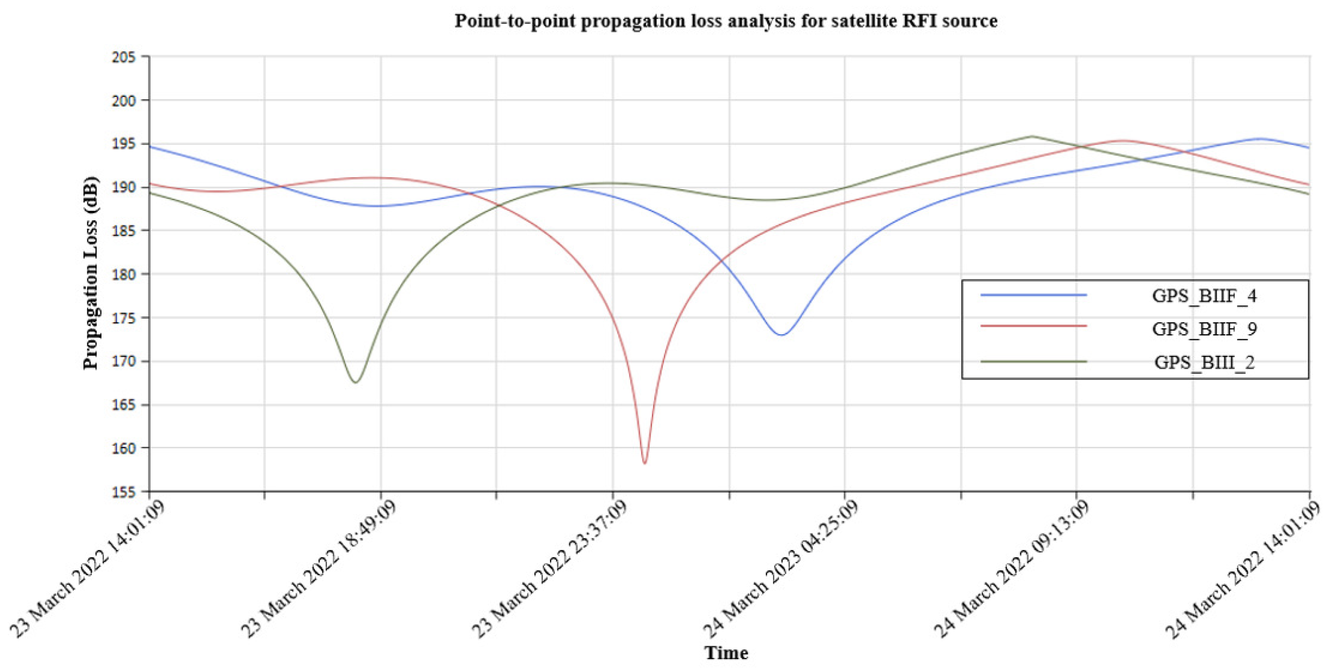
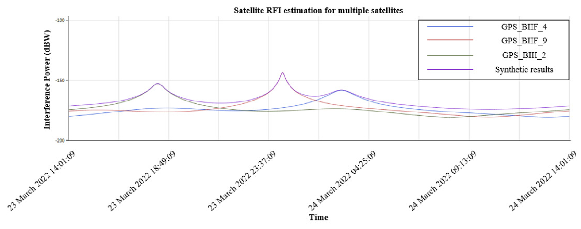
3.2. Satellite RFI Analysis

The operation of the satellite RFI analysis function is similar to that of the terrestrial analysis function. Satellite point-to-point radio wave propagation characteristic analysis requires the input of transmitting and receiving equipment information, which can be selected from the database or added manually. The input includes satellite information: name, operating frequency, power, main lobe shape and pointing angle1 2, and receiver information: name, location, sensitivity, main lobe azimuth and elevation angle. The corresponding radio meteorological parameters are also retrieved from the database, and the results are calculated using the appropriate algorithm model.
Figure 7 shows the analytical results of the satellite RFI point-to-point propagation characteristics. It gives the variations in the transmission losses of GPS_BIIF_4, GPS_BIIF_9, and GPS_BIII_2 to the receiving device with time. Furthermore, the computing results also can be output as a table.
In reality, interference of the satellite received by radio telescopes is usually the result of multiple satellites acting simultaneously. ITU-R M.1583-1 gives a method for calculating radio telescope interference from non-geostationary orbiting satellites [32]. However, it does not take into account the propagation loss between the satellite and the telescope. Our software combines the estimation method and propagation loss model to give a more realistic estimation.
Figure 8 shows the RFI estimation for multiple satellites including individual satellites and synthetic results. The corresponding time, satellite position, and interference power information can be saved as a table.
In this section, we present the main function of the software, including the propagation loss field strength computing for both terrestrial and satellite RFI sources. Furthermore, we compare the estimated results with actual tests for point-to-point terrestrial RFI sources. The experiments show that our models give identical results to the actual test and are more accurate compared with the free-space model.

4. Conclusions

In conclusion, we have constructed RFI analysis software for the radio environment around the radio telescope, combining complex information from celestial and satellite sources into a database. The database provides RFI sources, radio telescopes, and meteorological and geographic information, and users can add, delete, and modify the database for maintenance operations. The functional module provides the algorithms and interface to calculate the propagation loss for different kinds of RFI sources and environments. We further verified its accuracy by comparing the results of software analysis and practical tests.
With the software, we can use point-to-point analysis to evaluate the new transmitter and guide the subsequent installation and application of the transmitter. On the other hand, the software also provides point-to-area analysis to calculate the interference intensity distribution over an area, which can be useful for the selection of radio astronomical sites. The software is expected to be an efficient tool for protecting the radio environment around the radio telescope. In addition, interference analysis of satellites can guide us in choosing the observation time with minimum impact and support the division of spectrum resources in the future.

Author Contributions

Conceptualization, H.Z. and J.W.; methodology and software, J.W. and C.Y.; validation, Y.W., H.H. and S.H.; writing—original draft preparation, Y.W.; writing—review and editing, H.Z. and J.W.; supervision, H.Z. and J.W.; project administration, H.Z.; funding acquisition, H.Z. All authors have read and agreed to the published version of the manuscript.

Funding

This research was funded by the National Key R&D Program of China, No. 2021YFC2203204, the National Natural Science Foundation of China, No. 12273067 and the National Natural Science Foundation of China: No. 12041301.

Institutional Review Board Statement

Not applicable.

Data Availability Statement

Data sharing not applicable.

Conflicts of Interest

The authors declare no conflict of interest. The funders had no role in the design of the study; in the collection, analyses, or interpretation of data; in the writing of the manuscript; or in the decision to publish the results.

Abbreviations

The following abbreviations are used in this manuscript:
RFIRadio frequency interference
RQZRadio Quiet Zone
APIApplication Programming Interface
DEMDigital Elevation Model
FASTFive-hundred-meter Aperture Spherical radio Telescope
TLETwo-Line Elements

Notes

1
https://celestrak.org/, accessed on 22 March 2022.
2
https://www.space-track.org/, accessed on 22 March 2022.

References

  1. Baan, W.A. Implementing RFI mitigation in radio science. J. Astron. Instrum. 2019, 8, 1940010. [Google Scholar] [CrossRef]
  2. Zanichelli, A.; Serra, G.; Mack, K.; Nicotra, G.; Bartolini, M.; Cantini, F.; Biaggi, M.D.; Gaudiomonte, F.; Bortolotti, C.; Roma, M.; et al. Towards coordinated site monitoring and common strategies for mitigation of Radio Frequency Interference at the Italian radio telescope. arXiv 2022, arXiv:2207.07571. [Google Scholar]
  3. Katore, S.N.; Raybole, P.A.; Rai, S.; Nayak, S.; Kumar, S. Tools for avoiding satellite interference at the upgraded GMRT. In Proceedings of the 32nd URSI GASS, Montreal, QC, Canada, 19–26 August 2017. [Google Scholar]
  4. Wang, Y.; Zhang, H.Y.; Hu, H.; Huang, S.J.; Zhu, W.W.; Zhi, G.P.; Zhang, T.; Fan, Z.C.; Yang, L. Satellite RFI mitigation on FAST. Res. Astron. Astrophys. 2021, 21, 18. [Google Scholar] [CrossRef]
  5. Offringa, A.R.; De Bruyn, A.G.; Biehl, M.; Zaroubi, S.; Bernardi, G.; Pandey, V.N. Post-correlation radio frequency interference classification methods. Mon. Not. R. Astron. Soc. 2010, 405, 155–167. [Google Scholar] [CrossRef] [Green Version]
  6. Sardarabadi, A.M.; van der Veen, A.J.; Boonstra, A.J. Spatial filtering of RF interference in radio astronomy using a reference antenna array. IEEE Trans. Signal Process. 2016, 64, 432–447. [Google Scholar] [CrossRef]
  7. Zeng, Q.; Chen, X.; Li, X.; Han, J.L.; Wang, C.; Zhou, D.J.; Wang, T. Radio frequency interference mitigation based on the asymmetrically reweighted penalized least squares and SumThreshold method. Mon. Not. R. Astron. Soc. 2020, 500, 2969–2978. [Google Scholar] [CrossRef]
  8. Akeret, J.; Chang, C.; Lucchi, A.; Refregier, A. Radio frequency interference mitigation using deep convolutional neural networks. Astron. Comput. 2017, 18, 35–39. [Google Scholar]
  9. Yang, Z.C.; Yu, C.; Xiao, J.; Zhang, B. Deep residual detection of radio frequency interference for FAST. Mon. Not. R. Astron. Soc. 2020, 492, 1421–1431. [Google Scholar] [CrossRef] [Green Version]
  10. Mesarcik, M.; Boonstra, A.J.; Ranguelova, E.; van Nieuwpoort, R.V. Learning to detect radio frequency interference in radio astronomy without seeing it. Mon. Not. R. Astron. Soc. 2022, 516, 5367–5378. [Google Scholar] [CrossRef]
  11. Li, J.B.; Peng, B.; Liu, D.L. Site spectrum monitoring of electromagnetic environment for large radio telescopes. Chin. J. Radio Sci. 2015, 30, 378–382. [Google Scholar]
  12. Yang, C.; Wang, J.; You, X.; Haibin, S.U.; Shengyu, J.I.; Zhao, Z. Applicability of ITU-R P.1546 recommendation in typical terrestrial areas of CHINA. Chin. J. Radio Sci. 2019, 34, 295–301. [Google Scholar]
  13. Wang, Y.; Zhang, H.; Hu, H.; Huang, S.; Gan, H.; Wu, M.; Zhang, X.; Zhu, W. A Proposed RFI Intelligent Monitoring and Positioning System of FAST. In Proceedings of the 2020 XXXIIIrd General Assembly and Scientific Symposium of the International Union of Radio Science, Rome, Italy, 29 August–5 September 2020; IEEE: Piscataway, NJ, USA, 2020. [Google Scholar]
  14. Zhang, H. et al. [FAST Collaboration] RFI measurements and mitigation for FAST. Res. Astron. Astrophys. 2020, 20, 111–114. [Google Scholar]
  15. Wang, J.; Zhao, Y.B.; Shi, Y.F.; Yang, C.; Hao, Y.L.; Sun, J.M. The electromagnetic compatibility between FAST and public mobile communication stations and its cognitive using frequency strategy. Res. Astron. Astrophys. 2022, 22, 125005. [Google Scholar] [CrossRef]
  16. Nan, R.D. Five hundred meter aperture spherical radio telescope (FAST). Sci. China Ser. G 2006, 49, 129–148. [Google Scholar] [CrossRef]
  17. Chen, R.; Zhang, H.; Jin, C.; Gao, Z.; Zhu, Y.; Zhu, K.; Jiang, P.; Yue, Y.; Lu, J.; Zhang, B.; et al. FAST VLBI: Current status and future plans. Res. Astron. Astrophys. 2020, 20, 74. [Google Scholar] [CrossRef]
  18. Wang, N. Xinjiang Qitai 110 m radio telescope. Sci. Sin. Phys. Mech. Astron. 2014, 44, 783. [Google Scholar] [CrossRef]
  19. Liu, X.; Liu, T.; Shen, Z.; Qin, S.; Luo, Q.; Cheng, Y.; Gu, Q.; Zhang, T.; Zhu, F.; Liu, S.-Y.; et al. A Q-band Line Survey toward Orion KL Using the Tianma Radio Telescope. Astrophys. J. Suppl. Ser. 2022, 263, 13. [Google Scholar] [CrossRef]
  20. Wang, J.; Shi, Y.; Yang, C.; Ji, S.; Su, H. Research on Fading Characteristics of Ultrahigh Frequency Signals in Karst Landform Around Radio Quiet Zone of FAST. Radio Sci. 2020, 55, 10. [Google Scholar] [CrossRef]
  21. Recommendation ITU-R P.453-14, The Radio Refractive Index: Its Formula and Refractivity Data. 2019. Available online: https://www.itu.int/rec/R-REC-P.453/en (accessed on 21 April 2021).
  22. Recommendation ITU-R P.836-6, Water Vapour: Surface Density and Total Columnar Content. 2017. Available online: https://www.itu.int/rec/R-REC-P.836/en (accessed on 21 April 2021).
  23. Recommendation ITU-R P.837-7, Characteristics of Precipitation for Propagation Modeling. 2017. Available online: https://www.itu.int/rec/R-REC-P.837/en (accessed on 21 April 2021).
  24. Recommendation ITU-R P.839-4, Rain Height Model for Prediction Methods. 2013. Available online: https://www.itu.int/rec/R-REC-P.839/en (accessed on 21 April 2021).
  25. Recommendation ITU-R P.2001-4, a General Purpose Wide-Range Terrestrial Propagation Model in the Frequency Range 30 MHz to 50 GHz. 2021. Available online: https://www.itu.int/rec/R-REC-P.2001-4-202109-I/en (accessed on 10 April 2022).
  26. Recommendation ITU-R P.618, Propagation Data and Prediction Methods Required for the Design of Earth-Space Telecommunication Systems. 2017. Available online: https://www.itu.int/rec/R-REC-P.618-13-201712-I/en (accessed on 21 April 2021).
  27. Recommendation ITU-R P.679-4, Propagation Data Required for the Design of Broadcasting-Satellite Systems. 2015. Available online: https://www.itu.int/\rec/R-REC-P.679-4-201507-I/en (accessed on 21 April 2021).
  28. Recommendation ITU-R P.680, Propagation Data required for the Design of Earth-Space Maritime Mobile Telecommunication Systems. 2022. Available online: https://www.itu.int/rec/R-REC-P.680-4-202208-I/en (accessed on 9 November 2022).
  29. Recommendation ITU-R P.681, Propagation Data Required for the Design Systems in the Land Mobile-Satellite Service. 2019. Available online: https://www.itu.int/rec/R-REC-P.681-11-201908-I/en (accessed on 21 April 2021).
  30. Recommendation ITU-R P.682, Propagation Data Required for The Design of Earth-Space Aeronautical Mobile Telecommunication Systems. 2022. Available online: https://www.itu.int/rec/R-REC-P.682-4-202208-I/en (accessed on 9 November 2022).
  31. Han, H.; Yang, C.; Li, J.; Wang, J.; Wang, J. Research on the Applicability of ITU-R P. 2001 in the Typical Area of China. J. CAEIT 2022, 17, 977–1006. [Google Scholar]
  32. Recommendation ITU-R M.1583-1, Interference Calculations Between Non-Geostationary Mobile-Satellite Service or Radionavigation-Satellite Service Systems and Radio Astronomy Telescope Sites. 2007. Available online: https://www.itu.int/rec/R-REC-M.1583/en (accessed on 21 April 2021).
Figure 1. The schematic diagram of the RFI analysis software.
Universe 09 00277 g001
Figure 2. The specific architecture of the RFI analysis software.
Universe 09 00277 g002
Figure 3. The graphical user interface of the RFI analysis software.
Universe 09 00277 g003
Figure 4. The point-to-point analysis for terrestrial RFI source.
Universe 09 00277 g004
Figure 5. The point-to-area analysis for terrestrial RFI source.
Universe 09 00277 g005
Figure 6. The analytical results of propagation loss from Hanglong to FAST.
Universe 09 00277 g006
Figure 7. The point-to-point analysis for satellite RFI source.
Universe 09 00277 g007
Figure 8. The results of satellite RFI estimation.
Universe 09 00277 g008
Table 1. The parameters in the meteorological database.
No.Parameter NameUnit
1Vertical reflectivity gradient [21]N-units/km
2Average sea level value of surface reflectivity [21]N-units
3Average annual difference in the values of the reflectivity at the surface and 1000 m above the surface [21]N-units/km
4Wet term of the surface reflectivity [21]ppm
5Surface water vapor density [22]g/m 3
6Mean annual rainfall amount [23]mm
7Ratio of convective to total rainfall amount [23]-
8Probability of rainy 6-hours periods [23]%
90 degree isotherm height [24]km
10Mean rain height [24]km
Table 2. Scope of application of different types of wave propagation calculation models.
No.Model NameSupported Frequency RangeServices
1Terrestrial radio wave propagation prediction model [25]30 MHz∼50 GHzradio, mobile communication, television, radar
2Earth–Space radio wave propagation prediction model [26,27,28,29,30]1 GHz∼55 GHzcommunication, navigation, radio, television
Table 3. The point-to-point analytical results for terrestrial RFI source.
Distance (km)Altitude (m)Field Strength
(dB μ V/m)
Free-Space Propagation
(dB μ V/m)
0120687.78107.77
3.791104.333.0376.21
7.571154.231.1970.18
11.361091.718.7966.66
15.151198.325.464.16
18.931103.420.862.23
22.72101721.4360.64
26.51823.913.6459.3
30.29837.9−13.4658.14
34.089030.0557.12
Table 4. The point-to-point analytical results for terrestrial RFI source.
Longitude ( E)Latitude ( N)Distance (km)Altitude (m)Field Strength
(dB μ V/m)
Propagation Loss (dB)
106.1411926.2019269.88517444.477169.987
106.1411926.2435967.25617515.465168.97
106.1411926.2852664.87817606.457167.978
106.1411926.3269262.73917717.42167.015
106.1411926.3685960.87817848.304166.13
106.1411926.4102659.32117969.129165.306
106.1411926.4519258.09218049.712164.722
106.1411926.4935957.21318039.949164.486
106.1411926.5352656.70117839.718164.717
..................
Disclaimer/Publisher’s Note: The statements, opinions and data contained in all publications are solely those of the individual author(s) and contributor(s) and not of MDPI and/or the editor(s). MDPI and/or the editor(s) disclaim responsibility for any injury to people or property resulting from any ideas, methods, instructions or products referred to in the content.

