

Forest Inventories in Private and Protected Areas of Paraguay

Abstract
:1. Introduction and Background
1.1. Biological, Climatic and Landscape Characterization of the Studied Area
1.2. Status of Forest Management Practices in Both Land Tenure Regimes
2. Materials and Methods
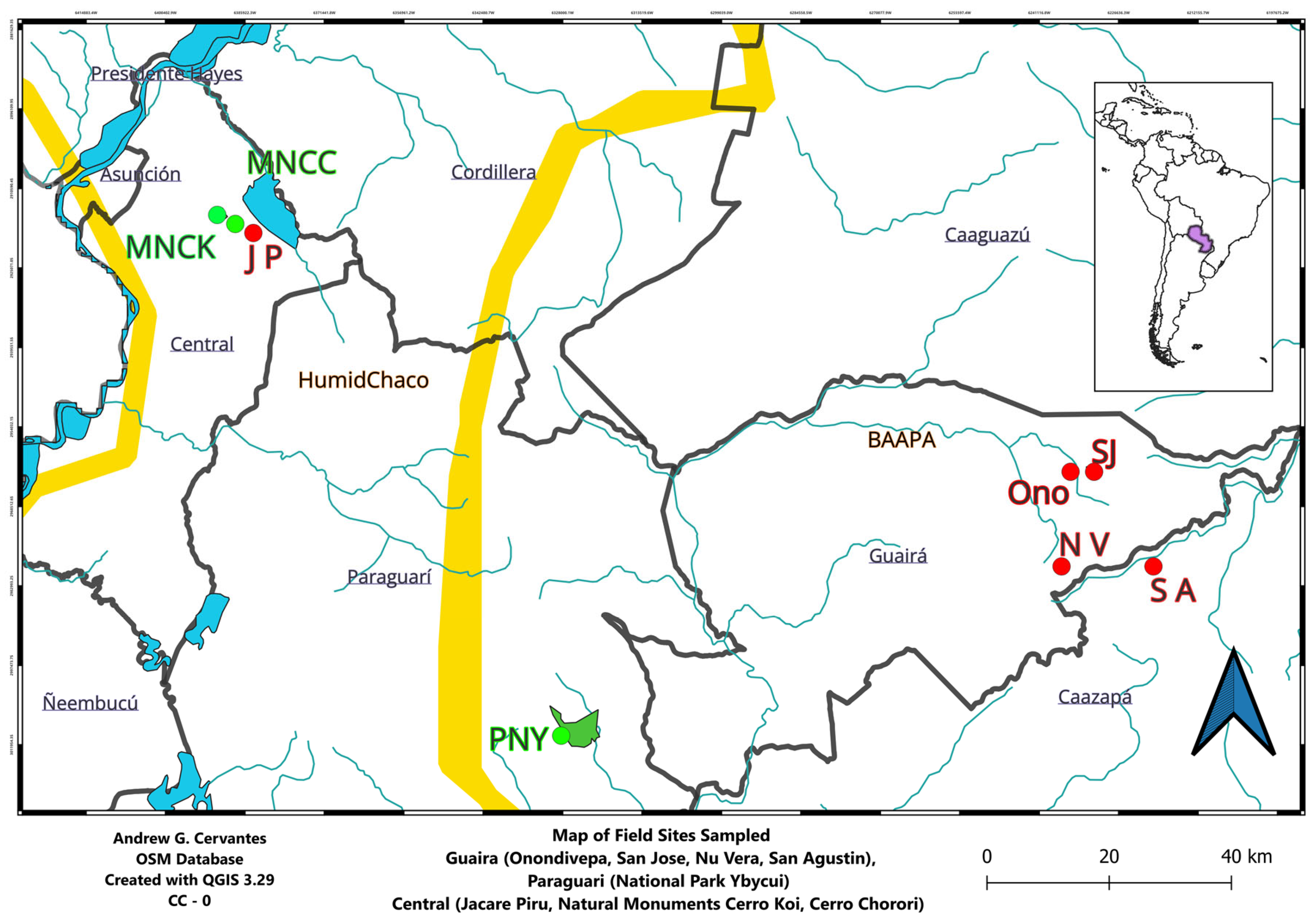
2.1. Description of Areas Studied
2.2. Methodology
2.3. Data Analysis
3. Results
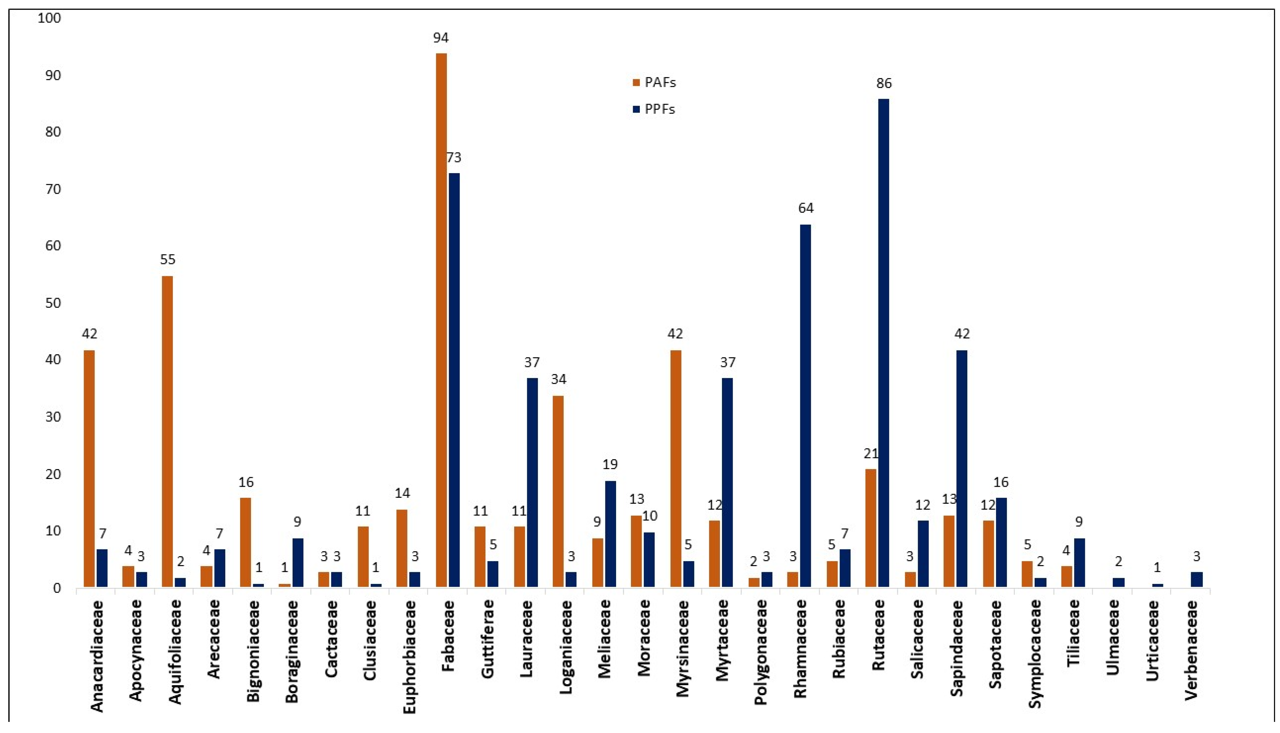
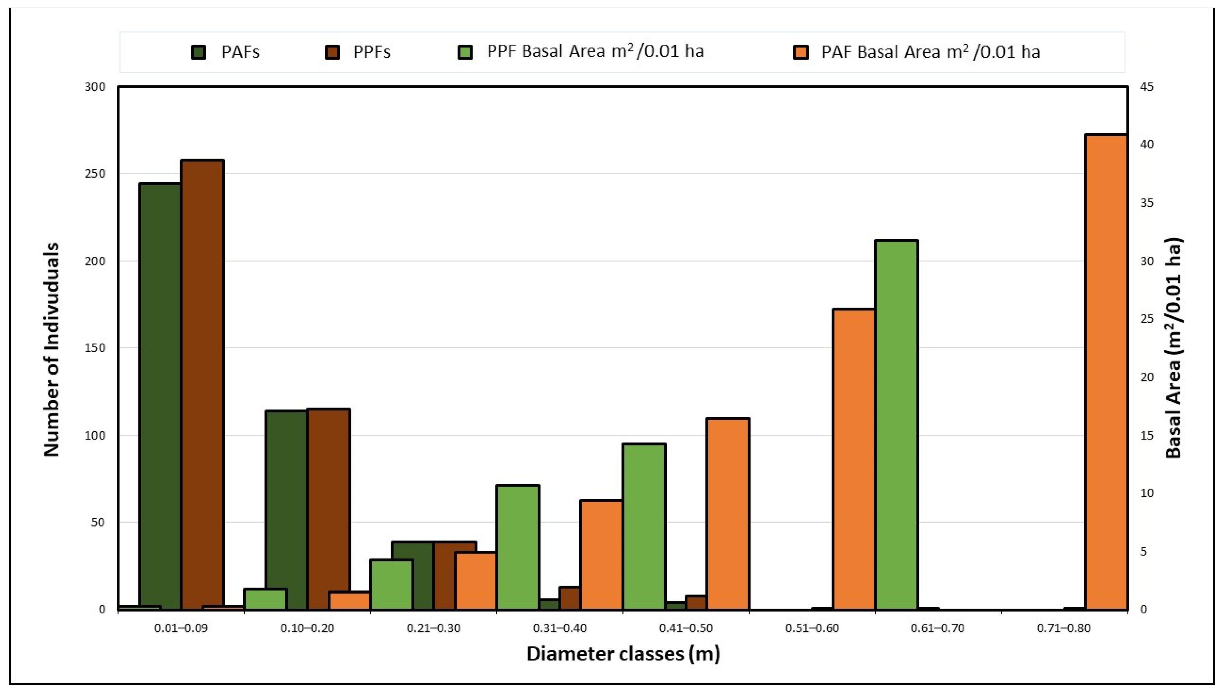
3.1. Dimensional and Taxonomic Comparisons between Protected and Private Forests
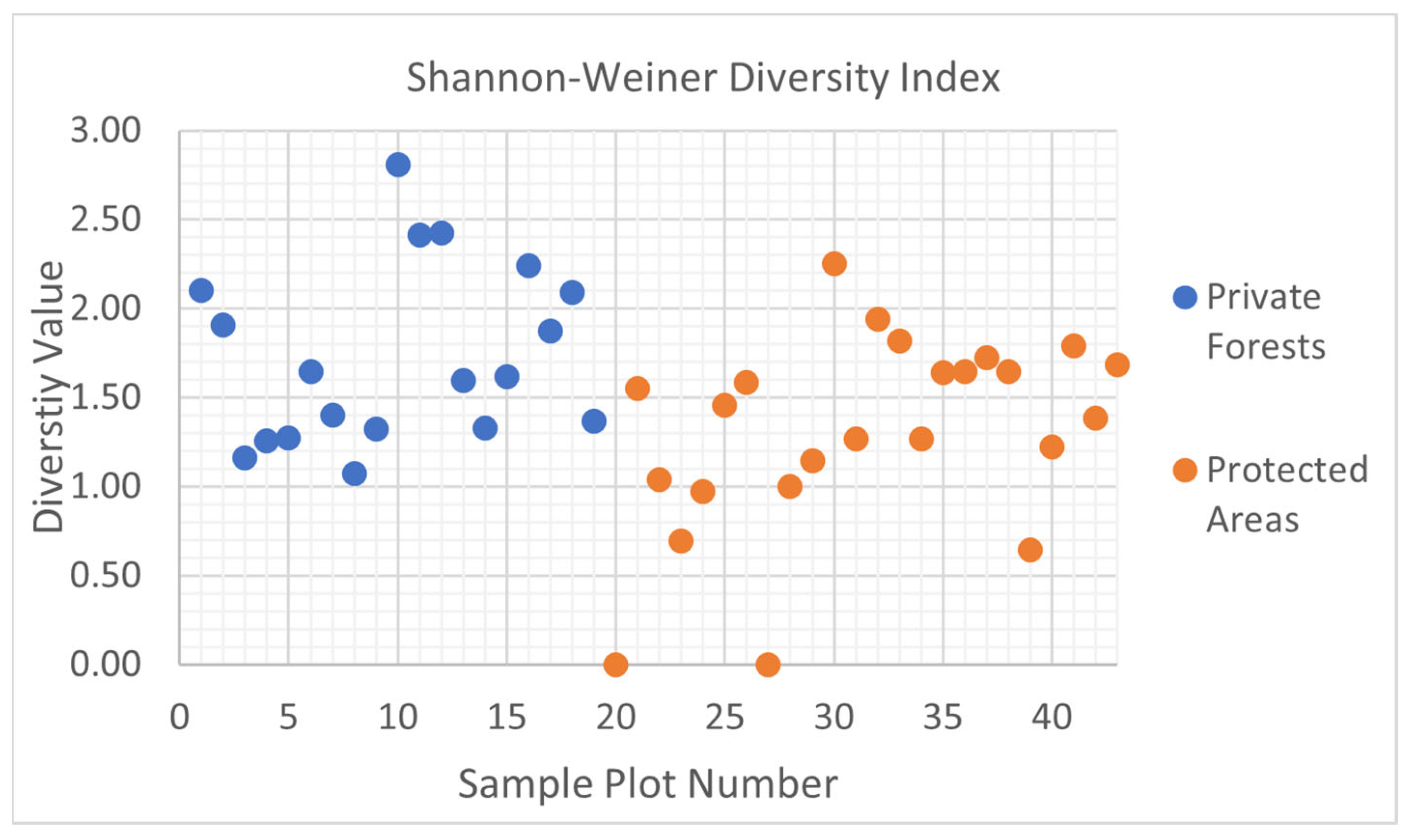
3.2. The Important Value Index and Shannon–Wiener Diversity Index
4. Discussion
5. Conclusions
Author Contributions
Funding
Institutional Review Board Statement
Informed Consent Statement
Data Availability Statement
Acknowledgments
Conflicts of Interest
Appendix A

| Site | Plot No. | Mgmt. | Eco Region | Coordinates | Ele. (m) | Gnd. Cvr. (%) | Tot. Area (m2) | Scale Factor |
|---|---|---|---|---|---|---|---|---|
| G1-SJ1 | 1 | PF | AF | 25°41.426′ S 55°59.140′ W | 264.0 | 75 | 100 | 0.0059 |
| G1-SJ2 | 2 | PF | AF | 25°41.419′ S 55°59.135′ W | 262.1 | 85 | 100 | |
| G1-SJ3 | 3 | PF | AF | 25°41.435′ S 55°59.129′ W | 259.4 | 95 | 100 | |
| G1-Oño1 | 4 | PF | AF | 25°41.962′ S 56° 20.145′ W | 283.4 | 80 | 100 | |
| G1-Oño2 | 5 | PF | AF | 25°41.273′ S 56° 13.460′ W | 232.6 | 65 | 100 | |
| G1-Oño3 | 6 | PF | AF | 25°41.362′ S 56° 24.440′ W | 235.3 | 75 | 100 | |
| G2-SA1 | 7 | PF | AF | 25°50.334′ S 55°52.597′ W | 242.9 | 90 | 100 | 0.0248 |
| G2-SA2 | 8 | PF | AF | 25°50.862′ S 55°52.967′ W | 243.2 | 70 | 100 | |
| G2-SA3 | 9 | PF | AF | 25°50.809′ S 55°52.988′ W | 242.3 | 60 | 100 | |
| G2-NV1 | 10 | PF | AF | 25°50.486′ S 56° 02.316′ W | 210.9 | 45 | 100 | |
| G2-NV2 | 11 | PF | AF | 25°50.027′ S 56°02.061′ W | 196.9 | 50 | 100 | |
| G2-NV3 | 12 | PF | AF | 25°50.058′ S 56°02.019′ W | 198.4 | 70 | 100 | |
| JP 1 | 13 | PF | CH | 25°19.632′ S 57°22.809′ W | 110.3 | 65 | 100 | 0.0011 |
| JP 2 | 14 | PF | CH | 25°19.582′ S 57°22.623′ W | 130.5 | 70 | 100 | |
| JP 3 | 15 | PF | CH | 25°19.839′ S 57°22.884′ W | 144.8 | 50 | 100 | |
| JP 4 | 16 | PF | CH | 25°19.672′ S 57°22.795′ W | 99.7 | 83 | 100 | |
| JP 5 | 17 | PF | CH | 25°19.556′ S 57°22.585′ W | 109.7 | 55 | 100 | |
| JP 6 | 18 | PF | CH | 25°19.532′ S 57°22.587′ W | 127.7 | 80 | 100 | |
| JP 7 | 19 | PF | CH | 25°19.826′ S 57°22.968′ W | 134.1 | 85 | 100 | |
| MNCK 1 | 20 | PA | CH | 25°19.474′ S 57°23.762′ W | 176.8 | 40 | 100 | 0.045 |
| MNCK 2 | 21 | PA | CH | 25°19.543′ S 57°23.807′ W | 167.3 | 65 | 100 | |
| MNCK 3 | 22 | PA | CH | 25°19.485′ S 57°23.839′ W | 209.1 | 70 | 100 | |
| MNCK 4 | 23 | PA | CH | 25°19.437′ S 57°23.916′ W | 141.1 | 90 | 100 | |
| MNCK 5 | 24 | PA | CH | 25°19.341′ S 57°24.020′ W | 192.9 | 83 | 100 | |
| MNCK 6 | 25 | PA | CH | 25°19.332′ S 57°24.049′ W | 192.6 | 90 | 100 | |
| MNCK 7 | 26 | PA | CH | 25°19.311′ S 57°24.079′ W | 198.7 | 97 | 100 | |
| MNCK 8 | 27 | PA | CH | 25°18.806′ S 57°24.212′ W | 192.9 | 100 | 100 | |
| MNCK 9 | 28 | PA | CH | 25°19.439′ S 57°23.903′ W | 633 ft | 70 | 100 | |
| MNCC 1 | 29 | PA | CH | 25°18.837′ S 57°24.105′ W | 168.3 | 55 | 100 | 0.018 |
| MNCC 2 | 30 | PA | CH | 25°18.880′ S 57°24.153′ W | 167.3 | 40 | 100 | |
| MNCC 3 | 31 | PA | CH | 25°18.873′ S 57°24.134′ W | 159.1 | 60 | 100 | |
| MNCC 4 | 32 | PA | CH | 25°18.811′ S 57°24.212′ W | 199.6 | 80 | 100 | |
| MNCC 5 | 33 | PA | CH | 25°18.838′ S 57°24.103′ W | 160.0 | 50 | 100 | |
| MNCC 6 | 34 | PA | CH | 25°18.832′ S 57°24.257′ W | 167.3 | 60 | 100 | |
| MNCC 7 | 35 | PA | CH | 25°18.785′ S 57°24.129′ W | 168.9 | 33 | 100 | |
| MNCC 8 | 36 | PA | CH | 25°18.786′ S 57°24.211′ W | 188.1 | 75 | 100 | |
| MNCC 9 | 37 | PA | CH | 25°18.787′ S 57°24.210′ W | 182.9 | 63 | 100 | |
| PNY 1 | 38 | PA | AF | 26°05.574′ S 56°50.771′ W | 198.7 | 73 | 100 | 0.000012 |
| PNY 2 | 39 | PA | AF | 26°03.121′ S 56°52.181′ W | 275.5 | 40 | 100 | |
| PNY 3 | 40 | PA | AF | 26°02.252′ S 56°51.687′ W | 363.6 | 92 | 100 | |
| PNY 4 | 41 | PA | AF | 26°05.473′ S 56°50.282′ W | 119.8 | 80 | 100 | |
| PNY 5 | 42 | PA | AF | 26°04.077′ S 56°50.938′ W | 195.4 | 75 | 100 | |
| PNY 6 | 43 | PA | AF | 26°04.423′ S 56°50.615′ W | 222.5 | 50 | 100 |
| Private Property Forests | |||
|---|---|---|---|
| Family | Genera | Species | Quantity |
| Rhamnaceae | Columbrina | Columbrina retusa var. latifolia | 60 |
| Rutaceae | Pilocarpus | Pilocarpus pennatifolius | 59 |
| Fabaceae | Peltophorum | Peltophorum dubium | 24 |
| Sapindaceae | Cupania | Cupania vernalis | 24 |
| Lauraceae | Ocotea | Ocotea suaveolens | 20 |
| Rutaceae | Zanthoxylum | Zanthoxylum petiolare | 20 |
| Myrtaceae | Plinia | Plinia rivularis | 19 |
| Fabaceae | Parapiptadenia | Parapiptadenia rigida | 18 |
| Fabaceae | Lonchocarpus | Lonchocarpus leucanthus | 12 |
| Meliaceae | Trichilia | Trichilia catigua | 12 |
| Salicaceae | Casearia | Casearia sylvestris | 12 |
| Sapotaceae | Chrysophyllum | Chrysophyllum gonocarpum | 11 |
| Tiliaceae | Luehea | Luehea divaricata | 9 |
| Anacardiaceae | Astronium | Astronium fraxinifolium | 7 |
| Moraceae | Ficus | Ficus sp. | 7 |
| Rubiaceae | Genipa | Genipa americana | 7 |
| Sapindaceae | Allophylus | Allophylus edulis | 7 |
| Arecaceae | Syagrus | Syagrus romanzoffiana | 6 |
| Clusiaceae | Rheedia | Rheedia brasiliensis | 6 |
| Fabaceae | Myrocarpus | Myrocarpus frondosus | 6 |
| Myrtaceae | Plinia | Plinia peruviana | 6 |
| Sapindaceae | Diplokeleba | Diplokeleba floribunda | 6 |
| Boraginaceae | Cordia | Cordia americana | 5 |
| Meliaceae | Trichilia | Trichilia pallida | 5 |
| Myrsinaceae | Rapanea | Rapanea lorentziana | 5 |
| Sapotaceae | Chrysophyllum | Chrysophyllum marginatum | 5 |
| Fabaceae | Anadenanthera | Anadenanthera columbrina | 4 |
| Myrtaceae | Hexachlyamys | Hexachlyamys edulis | 4 |
| Apocynaceae | Tabernaemontana | Tabernaemontana australis | 3 |
| Boraginaceae | Cordia | Cordia ecalyculata | 3 |
| Fabaceae | Albizia | Albizia niopoides | 3 |
| Lauraceae | Ocotea | Ocotea disopyrifolia | 3 |
| Lauraceae | Nectrandra | Nectandralanceolata | 3 |
| Loganiaceae | Strychnos | Strychnos brasiliensis | 3 |
| Myrtaceae | Campomanesia | Campomanesia xanthocarpa | 3 |
| Polygonaceae | Ruprechita | Ruprechita laxiflora | 3 |
| Rhamnaceae | Hovenia | Hovenia dulcis | 3 |
| Rutaceae | Citrus | Citrus aurantium | 3 |
| Sapindaceae | Diatenopteryx | Diatenopteryx sorbifolia | 3 |
| Verbenaceae | Vitex | Vitex megapotamica | 3 |
| Aquifoliaceae | Ilex | Ilex paraguariensis | 2 |
| Euphorbiaceae | Actinostemon | Actinostemon concolor | 2 |
| Fabaceae | Machaerium | Machaerium acuifolium | 2 |
| Fabaceae | Gleditsia | Gleditsia amorphoides | 2 |
| Fabaceae | Copaifera | Copaifera langsdorfii | 2 |
| Moraceae | Cecropia | Cecropia pachystachya | 2 |
| Myrtaceae | Eugenia | Eugenia uniflora | 2 |
| Rutaceae | Balfourrodendron | Balfourrodendron riedelianum | 2 |
| Symplocaceae | Symplocos | Symplocos sp. | 2 |
| Ulmaceae | Celtis | Celtis pubescens | 2 |
| Arecaceae | Acrocomia | Acrocomia aculeata | 1 |
| Bignoniaceae | Handroanthus | Handroanthus heptaphylla | 1 |
| Boraginaceae | Cordia | Cordia trichotma | 1 |
| Cactaceae | Cereus | Cereus stenogonus | 1 |
| Cactaceae | Praecereus | Praecereus euchlorus | 1 |
| Caricaceae | Jacaratia | Jacaratia spinosa | 1 |
| Euphorbiaceae | Manihot | Manihot grahamii | 1 |
| Fabaceae | Enterlobium | Enterlobium contrortosiliquum | 1 |
| Fabaceae | Pterogyne | Pterogyne nitens | 1 |
| Fabaceae | Calliandra | Calliandra tweediei | 1 |
| Fabaceae | Inga | Inga uruguensis | 1 |
| Lauraceae | Ocotea | Ocotea puberula | 1 |
| Meliaceae | Cedrela | Cedrela fissilis | 1 |
| Meliaceae | Cabralea | Cabralea canjerana | 1 |
| Moraceae | Chlorophora | Chlorophora tinctoria | 1 |
| Myrtaceae | Capparicordis | Capparicordis tweediana | 1 |
| Rhamnaceae | Rhamnidium | Rhamnidium elaeocarpum | 1 |
| Rutaceae | Helietta | Helietta apiculata | 1 |
| Rutaceae | Fagara | Fagara naranjillo | 1 |
| Sapindaceae | Melicoccus | Melicoccus lepidopetalus | 1 |
| Sapindaceae | Diatenopteryx | Diatenopteryx sorbifolia | 1 |
| Urticaceae | Urera | Urera baccifera | 1 |
| Protected Area Forests | |||
| Family | Genera | Species | Quantity |
| Arecaceae | Acrocomia | Acrocomia aculeata | 54 |
| Anacardiaceae | Astronium | Astronium fraxinifolium | 32 |
| Fabaceae | Copaifera | Copaifera langsdorfii | 30 |
| Myrtaceae | Plinia | Plinia rivularis | 29 |
| Fabaceae | Parapiptadenia | Parapiptadenia rigida | 28 |
| Meliaceae | Trichilia | Trichilia pallida | 16 |
| Boraginaceae | Patagonula | Patagonula americana | 15 |
| Euphorbiaceae | Actinostemon | Actinostemon concolor | 13 |
| Myrsinaceae | Rapanea | Rapanea lorentziana | 13 |
| Rutaceae | Helietta | Helietta apiculata | 12 |
| Fabaceae | Peltophorum | Peltophorum dubium | 12 |
| Clusiaceae | Rheedia | Rheedia brasiliensis | 11 |
| Sapotaceae | Chrysophyllum | Chrysophyllum gonocarpum | 10 |
| Malvaceae | Guazuma | Guazuma ulmifolia | 10 |
| Fabaceae | Anadenanthera | Anadenanthera columbrina | 9 |
| Meliaceae | Trichilia | Trichilia catigua | 9 |
| Sapindaceae | Diatenopteryx | Diatenopteryx sobifolia | 8 |
| Lauraceae | Ocotea | Ocotea suaveolens | 8 |
| Nyctaginaceae | Rychenbachia | Rychenbachia paraguayensis | 8 |
| Anacardiaceae | Astronium | Astronium urundeuva | 7 |
| Rubiaceae | Genipa | Genipa americana | 6 |
| Fabaceae | Albizia | Albizia hassleri | 5 |
| Moraceae | Ficus | Ficus enormis | 5 |
| Fabaceae | Holocalyx | Holocalyx balansae | 5 |
| Tiliaceae | Luehea | Luehea divaricata | 5 |
| Myrtaceae | Myrciaria | Myrciaria cuspidata | 5 |
| Meliaceae | Cedrela | Cedrela fissilis | 4 |
| Ulmaceae | Celtis | Celtis pubescens | 4 |
| Rutaceae | Citrus | Citrus aurantium | 4 |
| Sapindaceae | Cupania | Cupania vernalis | 4 |
| Fabaceae | Machaerium | Machaerium paraguariense | 4 |
| Rutaceae | Pilocarpus | Pilocarpus pennatifolius | 4 |
| Nyctaginaceae | Pisonia | Pisonia aculeata | 4 |
| Salicaceae | Casearia | Casearia gossypiosperma | 3 |
| Moraceae | Cecropia | Cecropia pachystachya | 3 |
| Myrtaceae | Hexachlamys | Hexachlamys edulis | 3 |
| Myrtaceae | Psidium | Psidium guayaba | 3 |
| Rhamnaceae | Rhamnidium | Rhamnidium elaeocarpum | 3 |
| Annonaceae | Rollinia | Rollinia emarginata | 3 |
| Cannabaceae | Trema | Trema micrantha | 3 |
| Meliaceae | Cabralea | Cabralea canjerana | 2 |
| Rubiaceae | Coutarea | Coutarea hexandra | 2 |
| Lauraceae | Nectandra | Nectandra lanceolata | 2 |
| Piperaceae | Piper | Piper amalago | 2 |
| Sapotaceae | Sideroxylon | Sideroxylon obtusifolium | 2 |
| Sapindaceae | Allophylus | Allophylus edulis | 1 |
| Myrtaceae | Campomanesia | Campomanesia xanthocarpa | 1 |
| Cactaceae | Cereus | Cereus stenogonus | 1 |
| Boraginaceae | Cordia | Cordia americana | 1 |
| Boraginaceae | Cordia | Cordia ecalyculata | 1 |
| Boraginaceae | Cordia | Cordia trichotma | 1 |
| Rutaceae | Fagara | Fagara rhoifolia | 1 |
| Binoniaceae | Handroanthus | Handroanthus impetiginosus | 1 |
| Malvaceae | Heliocarpus | Heliocarpus americanus subsp. Popayanensis | 1 |
| Bignoniaceae | Hexandra | Hexandra heptaphylla | 1 |
| Fabaceae | Inga | Inga uruguensis | 1 |
| Anacardiaceae | Lithraea | Lithraea molleoides | 1 |
| Myrtaceae | Plinia | Plinia peruviana | 1 |
| Lauraceae | Ocotea | Ocotea diospyrifolia | 1 |
| Euphorbiaceae | Sapium | Sapium hematospermum | 1 |
| Moraceae | Sorocea | Sorocea bonplandii | 1 |
| Arecaceae | Syagrus | Syagrus romanzoffiana | 1 |
| Annonaceae | Xylopia | Xylopia brasiliensis | 1 |
References
- World Wildlife Fund Paraguay (WWF Paraguay). El Cambio Climático, los Bosques y las Medidas Para Reducir las Emisiones Provenientes de la Deforestación; WWF: Asunción, Paraguay, 2016. [Google Scholar]
- Food and Agriculture Organization of the United Nations (FAO). National Forest Inventory—Field Manual Template; FAO: Rome, Italy, 2004. [Google Scholar]
- Resico, C. Análisis de la Información Sobre Productos Forestales no Madereros en Paraguay; FAO: Santiago, Chile, 2001. [Google Scholar]
- International Tropical Timber Organization (ITTO); International Union for the Conservation of Nature (IUCN). Guidelines for the Conservation and Sustainable Use of Biodiversity in Tropical Timber Production Forests; ITTO Policy Development Series No. 17; ITTO: Yokohama, Japan; IUCN: Gland, Switzerland, 2009; 120p. [Google Scholar]
- Naumann, C.M.; Coronel, M.M. Atlas Ambiental del Paraguay: Con Fines Educativos; Cooperación Técnica Alemana (GTZ), Secretaria del Ambiente del Paraguay (SEAM) y Ministerio de Educación y Cultura del Paraguay (MEC): Asunción, Paraguay, 2008. [Google Scholar]
- Williams, M. Deforesting the Earth; The University of Chicago Press: Chicago, IL, USA, 2006. [Google Scholar]
- Dirección General de Estadísticas, Encuestas y Censo (DGEEC). Censo Nacional de Población y Viviendas; DGEEC: Fernando de la Mora, Paraguay, 2022.
- World Fact Book. Paraguay. Available online: https://www.cia.gov/the-world-factbook/ (accessed on 20 February 2023).
- Zanardini, J. Los Pueblos Indígenas del Paraguay; El Lector: Asunción, Paraguay, 2010. [Google Scholar]
- Spichiger, R.; Ramella, L.; Bocquet, G.; Perret, P. Flora del Paraguay 1–40; Conservatoire Jardín Botaniques de la Ville de Genève, Suiza & Missouri Botanical Garden: St. Louis, MO, USA, 1983. [Google Scholar]
- Pin, A.; González, G.; Marín, G.; Céspedes, G.; Cretton, S.; Christen, P.; Roguet, D. Plantas Medicinales del Jardín Botánico de Asunción; Asociación Etnobotánica Paraguaya: Asunción, Paraguay, 2009; 441p. [Google Scholar]
- Kimmerer, R.W. Braiding Sweetgrass; Milkweed Editions: Minneapolis, MN, USA, 2013. [Google Scholar]
- ABC Color. Arboles del Paraguay: Donde Hay un Árbol Hay Vida; Editorial Azeta: Asunción, Paraguay, 2017. [Google Scholar]
- Benitez, B.; González, F.; Pérez, S.; Bertoni, S. Elaboración de artesanía popular en madera en comunidades urbanas de Asunción, Areguá y Tobatí (Paraguay). Rojasiana 2018, 8, 10–25. [Google Scholar] [CrossRef]
- López, J.A.; Little, E.; Rits, G.; Rombols, J.; Hahn, W. Arboles Comunes del Paraguay: Ñandeyvyramatakuera; FCA-UNA: San Lorenzo, Paraguay; Cuerpo de Paz Paraguay: Asunción, Paraguay, 1987; 435p. [Google Scholar]
- Céspedes, G.; Weber, E.; González, G. Especies Útiles de la Flora Paraguaya: Frutos Comestibles; Asociación Etnobotánica Paraguaya: Asunción, Paraguay, 2008. [Google Scholar]
- Cooperación Alemana al Desarrollo (GTZ); Facultad de Ciencias Agrarias-Universidad Nacional de Asunción (FCA-UNA). Practical Guide to Tree Species of the Eastern Region of Paraguay; GTZ: Asunción, Paraguay; FCA-UNA: San Lorenzo, Paraguay, 2007. [Google Scholar]
- Cuerpo de Paz Paraguay. Manual Técnico: Los Árboles Más Utilizados en el Paraguay; Cuerpo de Paz Paraguay: Asunción, Paraguay, 1999. [Google Scholar]
- Cacciali, P.; Scott, N.J.; Aquino Ortiz, A.L.; Fitzgerald, L.A.; Smith, P. The reptiles of Paraguay: Literature distribution, and an annotated taxonomic checklist. Spec. Publ. Mus. Southwest. Biol. 2016, 11, 1–373. [Google Scholar]
- Ministerio del Ambiente y Desarrollo Sostenible (MADES). Quinto Informe Nacional al Convenio de Diversidad Biológica; MADES: Asunción, Paraguay, 2016; 232p.
- Mereles, F.M.; Cartes, J.L.; Clay, R.P.; Cacciali, P.; Paradeda, C.; Rodas, O.; Yanosky, A. Análisis cualitativo para la definición de las ecorregiones de Paraguay occidental. Paraquaria Nat. 2013, 1, 12–20. [Google Scholar]
- Secretaría del Ambiente (SEAM). Por la Cual se Establecen las Ecorregiónes para las Regiones Oriental y Occidental del Paraguay; Resolución No. 614/2013; SEAM: Asunción, Paraguay, 2013; 3p.
- Secretaría de Emergencia Nacional (SEN). Atlas de Riesgos de Desastres de la Republica del Paraguay; SEN: Asunción, Paraguay, 2018; 182p.
- Pérez de Molas, L.F. Algunos Árboles y Arbustos del Chaco: Guía de Campo Para el Reconocimiento de las Especies; MADES: Asunción, Paraguay; UNDP: Asunción, Paraguay; FCA-UNA: San Lorenzo, Paraguay, 2021; 117p. [Google Scholar]
- Narosky, T.; Zurieta, D. Guía para la Identificación de las Aves de Paraguay; Vázquez Mazzini Editores: Buenos Aires, Argentina, 2006; 240p. [Google Scholar]
- Lesterhuis, A.J.; Bueno Villafane, D.; Cabral, H.; Rojas, V. Guia de Aves del Chaco Seco Paraguayo; Guyra Paraguay: Asunción, Paraguay, 2018; 96p. [Google Scholar]
- Zyskowski, K.; Robbins, M.B.; Townsend Peterson, K.S.; Bostwick, R.P.; Clay, L.; Amarilla, A. Avifauna of the Northern Paraguayan Chaco. Ornitol. Neotrop. 2003, 14, 247–262. [Google Scholar]
- Gamarra de Fox, I.; Martin, A.J. Lista de Mamíferos del Paraguay in Colecciones de Fauna y Flora del Museo Nacional de Historia del Paraguay; Dirección de Parques Nacionales y Vida Silvestre: Asunción, Paraguay, 1996. [Google Scholar]
- Weiler, A.; Núñez, K.; Airaldi, E.; Lavilla, S.; Baldo, D. Anfibios del Paraguay; Facultad de Ciencias Exactas y Naturales, Universidad Nacional de Asunción—Universidad de Salamanca: San Lorenzo, Paraguay, 2013; 134p. [Google Scholar]
- Food and Agriculture Organization of the United Nations (FAO); Pérez de Molas, L.F. Manual de Familias y Géneros de Árboles del Paraguay; INFONA: San Lorenzo, Paraguay, 2016; 228p. [Google Scholar]
- Bernardi, L. Contribución a la Dendrología Paraguaya. Boissiera 1984, 35, 1–341. [Google Scholar]
- Mereles, F.M. La Diversidad Vegetal en el Paraguay. In Biodiversidad del Paraguay, una Aproximación a sus Realidades, 1st ed.; Salas-Dueñas, D., Facetti, F., Eds.; Fundación Moisés Bertoni: Asunción, Paraguay, 2007; pp. 89–105. [Google Scholar]
- Bulter, R.; Mongabay. Total Number of Plant Species by Country. Available online: https://rainforests.mongabay.com/03plants.htm (accessed on 15 February 2023).
- Dos Santos, R.M. Atlas: Algas Del Paraguay Características e Importancia, Muestreo en Paraguay Clave de Identificación e Ilustraciones; FACEN-UNA: San Lorenzo, Paraguay, 2016; 234p. [Google Scholar]
- International Union for the Conservation of Nature (IUCN). The IUCN Red List of Threatened Species. Version 2021-2. Available online: https://www.iucnredlist.org (accessed on 15 December 2022).
- Ministerio del Ambiente y Desarrollo Sostenible (MADES). Por la Cual se Actualiza el Listado de las Especies Protegidas de la Vida Silvestre en Peligro de Extinción; Resolución No. 2243/06; MADES: Asunción, Paraguay, 2006.
- Walcott, J.; Thorley, J.; Kapos, V.; Miles, L.; Woroniecki, S.; Blaney, R. Mapping Multiple Benefits of REDD+ in Paraguay: Using Spatial Information to Support Land-Use Planning; UNEP-WCMC: Cambridge, UK, 2015; 50p. [Google Scholar]
- Mereles, M.F.; Céspedes, G.; Cartes, J.L.; Goerzen, R.; De Egea-Elsam, J.; Rodriguez, L.; Yanosky, A.; Villalba, L.; Weiler, A.; Cacciali, P. Biological Corridors as a Connectivity Tool in the Region of the Great American Chaco: Identification of Biodiversity Hotspots in the Ecoregions of the Paraguayan Chaco. Res. Ecol. 2020, 2, 20–26. [Google Scholar] [CrossRef]
- Myers, N. Threatened biotas: “Hot spots” in tropical forests. Environmentalist 1988, 8, 187–208. [Google Scholar] [CrossRef] [PubMed]
- Russell, A.; Mittermeier, N.M.; Mittermeier, C.G. Hotspots: Earth’s Biologically Richest and Most Endangered Terrestrial Ecoregions; Conservation International: Washington, DC, USA, 1999; 431p. [Google Scholar]
- Spichiger, R.; Palese, R.; Chautems, A.; Ramella, L. Origin, affinities, and diversity hot spots of the Paraguayan dendrofloras. Candollea 1995, 50, 515–537. [Google Scholar]
- Nori, J.R.; Torres, J.N.; Lescano, J.M.; Cordier, J.M.; Periago, M.E.; Baldo, D. Protected areas and spatial conservation priorities for endemic vertebrates of the Gran Chaco, one of the most threatened ecoregions of the world. Divers. Distrib. 2016, 22, 1212–1219. [Google Scholar] [CrossRef]
- Huang, C.; Kim, S.; Song, K.; Townshend, J.; Davis, P.; Altstatt, A.; Rodas, O.; Yanosky, A.; Clay, R.; Tucker, C.; et al. Assessment of Paraguay’s forest cover change using Landsat observations. Glob. Planet. Chang. 2009, 67, 1–12. [Google Scholar] [CrossRef]
- Potapov, P.; Hansen, M.C.; Pickens, A.; Hernandez-Serna, A.; Tyukavina, A.; Turubanova, S.; Zalles, V.; Li, X.; Khan, A.; Stolle, F.; et al. The Global 2000–2020 Land Cover and Land Use Change Dataset Derived from the Landsat Archive: First Results. Front. Remote Sens. 2022, 3, 856–903. [Google Scholar] [CrossRef]
- Vallejos, M.; Volante, J.N.; Mosciaro, M.J.; Vale, L.M.; Bustamante, M.L.; Paruelo, J.M. Transformation dynamics of the natural cover in the Dry Chaco ecoregion: A plot level geo-database from 1076 to 2012. J. Arid Environ. 2015, 123, 3–11. [Google Scholar] [CrossRef]
- El Surtidor. Los Invasores VIP del Paraguay. 2021. Available online: https://elsurti.com/oligarquia/especial/los-invasores-vip-del-paraguay (accessed on 17 April 2023).
- Earthsight. Grand Theft Chaco. Available online: https://www.earthsight.org.uk/grandtheftchaco-en (accessed on 17 April 2023).
- Earthsight. Grand Theft Chaco II. Available online: https://www.earthsight.org.uk/news/analysis-grand-theft-chaco-ii-the-vice-continues (accessed on 17 April 2023).
- Manzoni, M.; Garcia, L.; Achucarro, G. El Estronismo Climático que no nos Deja Respirar. 2021. Available online: https://elsurti.com/futuros/culpables/especial/estronismo-climatico (accessed on 17 April 2023).
- Ortega, M.G. Áreas Protegidas del Paraguay. ABC Color, Escolar. 2014. Available online: abc.com.py/edicion-impresa/suplementos/escolar/areas-protegidas-del-paraguay-1263666.html (accessed on 17 April 2023).
- Clark, P.T. Guía de los Parques Nacionales y Otras Áreas Silvestres Protegidas del Paraguay; Servicios Gráficos S.A.: Asunción, Paraguay, 2004. [Google Scholar]
- Sistema Nacional de Áreas Protegidas (SINASIP). Informe Nacional, Áreas Silvestres Protegidas del Paraguay; UNDP: Asunción, Paraguay, 2007.
- Ministerio del Ambiente y Desarrollo Sostenible (MADES). Ley de Deforestación Cero; No. 2524/04; MADES: Asunción, Paraguay, 2004.
- Programa Nacional Conjunto ONU-REDD+ (PNC ONU-REDD+); Secretaría del Ambiente (SEAM); Instituto Forestal Nacional (INFONA); Federación por la Autodeterminación de los Pueblos Indígenas (FAPI). Paraguay: Cambio de Uso de Suelo y Costos de Oportunidad—Sinergias entre REDD+ y la Ley de Valoración y Retribución de Servicios Ambientales; ONU Medio Ambiente: Asunción, Paraguay, 2016.
- World Wildlife Fund Paraguay (WWF Paraguay). El Presidente Mario Abdo Benítez Promulgo la Extensión de la Ley de Deforestación Cero para la Región Oriental por 10 Años; WWF Paraguay: Asunción, Paraguay, 2020. [Google Scholar]
- Ministerio del Ambiente y Desarrollo Sostenible (MADES). Registro Nacional del Cuerpo Nacional de Guardaparques de Áreas Silvestres Protegidas Bajo Dominio Público y Privado en el Marco de la Ley No. 352/1994; Resolución No. 333/2021; MADES: Asunción, Paraguay, 2021.
- International Union for the Conservation of Nature (IUCN). Rising Murder Toll of Park Rangers Calls for Tougher Laws; IUCN: Gland, Switzerland, 2014. [Google Scholar]
- Hill, K.; Padwe, J.; Bejyvagi, C.; Bepurangi, A.; Jakugi, F.; Tykuarangi, R.; Tykuarangi, T. Impact of hunting on large vertebrates in the Mbaracayu Reserve, Paraguay. Conserv. Biol. 1997, 11, 1339–1353. [Google Scholar] [CrossRef]
- Benitz, A. ‘On the edge’: Endangered Forest Cleared for Marijuana in Paraguay; Mongabay: Menlo Park, CA, USA, 2020. [Google Scholar]
- Quintana, J.; Morse, S. Social interactions and resource ownership in two private protected areas of Paraguay. J. Environ. Manag. 2005, 77, 64–78. [Google Scholar] [CrossRef]
- Fundación Moisés Bertoni. Comunicado. La Justicia Paraguaya Debe Castigar a los Responsables del Asesinato a los Guardaparques; Fundación Moisés Bertoni: Asunción, Paraguay, 2021. [Google Scholar]
- Secretaría Nacional Antidrogas (SENAD). Available online: www.senad.gov.py (accessed on 3 January 2023).
- Ministerio de Urbanismo, Vivienda y Hábitat (MUVH); Ministerio del Ambiente y Desarrollo Sostenible (MADES); United Nations Development Programme (UNDP); Fondo para el Medio Ambiente Mundial (FMAM). Manual de Infraestructura Verde Urbana; Proyecto “Asunción Ciudad Verde de las Américas—Vías a Sustentabilidad”; UNDP: Asunción, Paraguay, 2021.
- Rivarola, R. Introducción a la Planificación y Gestión de la Arborización Urbana en el Contexto Paraguayo. Unpublished work. 2019. [Google Scholar]
- Cespedes, G.R.; Ministerio del Ambiente y Desarrollo Sostenible (MADES); United Nations Development Programme (UNDP); Fondo para el Medio Ambiente Mundial (FMAM). Guía de Frutos de Especies Para la Arborización y Restauración Ecológica del Área Metropolitana de Asunción; Proyecto “Asunción Ciudad Verde de las Américas—Vías a la Sustentabilidad”; UNDP: Asunción, Paraguay, 2021; 108p.
- Instituto Forestal Nacional (INFONA). Nuestros Bosques: Reporte de la Cobertura Forestal y Cambios de Uso de la Tierra 2017 a 2020; INFONA: San Lorenzo, Paraguay, 2022; 78p.
- Instituto Forestal Nacional (INFONA). Primer Taller de Construcción Participativa del Plan Nacional de Restauración Forestal [Sistematización]; INFONA: San Lorenzo, Paraguay, 2022; 76p.
- Instituto Forestal Nacional (INFONA). Resumen Ejecutivo del Reporte Nacional de Cobertura Forestal y Cambios de Uso de la Tierra 2017 a 2020; INFONA: San Lorenzo, Paraguay, 2022; 12p.
- Secretaría del Ambiente (SEAM), Municipalidad de Areguá, Secretaría Nacional de Turismo (SENATUR). Plan de Manejo de los Monumentos Naturales Cerro Koi y Chorori—Periodo 2014–2019; SEAM: Asunción, Paraguay; SENATUR: Areguá, Paraguay, 2014.
- Facultad de Ciencias Agrarias-Universidad Nacional de Asunción (FCA-UNA). Plan de Manejo del Parque Nacional Ybycuí 2015-2025; MADES: Asunción, Paraguay, 2015; 210p. [Google Scholar]
- Ministerio de Obras Públicas y Comunicaciones (MOPC). Reserva de Recursos Manejados Lago Ypacaraí y el Sistema de Humedales Adyacentes. Plan de Manejo 2018–2028; MOPC: Fernando de la Mora, Paraguay, 2018.
- Food and Agriculture Organization of the United Nations (FAO). Plan de Manejo y Desarrollo Conceptual del Parque Nacional Ybycuí; Documento Técnico de Trabajo No. 5; SEAM/FCBT: Asunción, Paraguay, 1973. [Google Scholar]
- Morán, L. Propuesta de Zonificación del Parque Nacional Ybycuí Considerando su Realidad Ambiental y Socioeconómica. Master’s Thesis, Facultad de Ciencias Agrarias, Universidad Nacional de Asunción, San Lorenzo, Paraguay, 2012. [Google Scholar]
- Britos Cáceres, L.M. Diversidad y Ecología de la Vegetación en los Afloramientos Rocosos (Roquedales) del Parque Nacional Ybycuí. Master’s Thesis, Facultad de Ciencias Agrarias, Universidad Nacional de Asunción, San Lorenzo, Paraguay, 2017. [Google Scholar]
- Pin, A. Las Cactáceas del Parque Nacional Ybycuí; Boletín del Museo Nacional de Historia Natural del Paraguay: San Lorenzo, Paraguay, 1996. [Google Scholar]
- Soria, N.; Basulado, I. La Vegetación de los Cerros Koi y Chorori, Dpto. Central Paraguay. Rojasiana 2004, 6, 71–80. [Google Scholar]
- Arevalos, F.; Baez, M.; Ortiz, E.; Yanosky, A. Monitoreo de los cambios de uso de la tierra en el Gran Chaco. Paraquaria Nat. 2015, 3, 6–11. [Google Scholar]
- Vera, M.; Rolón, C.; Degen de Arrúa, R. Plantas Nativas del Cerrado de Aguará Ñu, Reserva Natural del Bosque Mbaracayú, Paraguay. In Rojasiana; Serie Especial No. 3; FCQ-UNA: San Lorenzo, Paraguay, 2017; 242p. [Google Scholar]
- Instituto Forestal Nacional (INFONA). Proyecto “Promoción de Plantaciones Forestales” Informe Final; INFONA: San Lorenzo, Paraguay, 2013.
- Instituto Forestal Nacional (INFONA). Manual de Plantaciones Forestales, Técnicas de Instalación y Manejo; INFONA: San Lorenzo, Paraguay, 2013.
- Food and Agriculture Organization of the United Nations (FAO). Manual de Campo: Procedimiento para la Planificación, Medición, y Registro de Información del Inventario Forestal Nacional del Paraguay; FAO: Asunción, Paraguay, 2015. [Google Scholar]
- Spinzi, A.M.; Franco, V.H. Estudio Geológico de Areguá (Cerros Koi y Chorori); MOPC: Asunción, Paraguay, 1981. [Google Scholar]
- Google Earth. Available online: https://earth.google.com/web/ (accessed on 25 March 2023).
- Random.org. Available online: https://www.random.org/ (accessed on 25 March 2023).
- Belart, F.; Grand, L. Tools for Measuring Your Forest; EC 1129; Oregon State University Extension Service: Corvallis, OR, USA, 2019. [Google Scholar]
- Zobrist, K.W.; Hanley, D.P.; Grotta, A.T.; Schnepf, C. Basic Forest Inventory Techniques for Family Forest Owners; Pacific Northwest Extension Publications—PNW 630; Washington State University: Washington, DC, USA, 2012. [Google Scholar]
- Missouri Botanical Garden. Tropicos. Inventario de Colecciones Botánicas de Paraguay. Available online: http://legacy.tropicos.org/ProjectAdvSearch.aspx?projectid=44&langid=66 (accessed on 30 January 2023).
- Instituto de Botánica Darwinion. Flora del Conosur: Catálogo de las Plantas Vasculares. Available online: http://www.darwin.edu.ar/proyectos/floraargentina/fa.html (accessed on 30 January 2023).
- Flora do Brasil. Jardim Botanico do Rio de Janeiro. Available online: http://floradobrasil.jbrj.gov.br/ (accessed on 30 January 2023).
- Suunto Precision Instruments. Clinometer User Guide; Suunto Oy: Vantaa, Finland, 2017. [Google Scholar]
- Kimmerer, T. Range and Importance Value. Available online: https://kimmerer.com/trees/importance-value/ (accessed on 10 January 2023).
- Nguyen, H.; Lamb, D.; Herbohn, J.; Firn, J. Designing Mixed Species Tree Plantations for the Tropics: Balancing Ecological Attributes of Species with Landholder Preferences in the Phyilippines. PLoS ONE 2014, 9, e98600. [Google Scholar] [CrossRef]
- Peña, M.J.L.; Reynel-Rodríguez, C.; Zevallos-Pollito, P.; Bulnes-Soriano, F.; Pérez-Ojeda del Arco, A. Diversidad, composición florística y endemismos en los bosques estacionalmente secos alterados del distrito de Jaén, Perú. Ecol. Apl. 2007, 6, 9–22. [Google Scholar] [CrossRef]
- Peña, M.J.L.; Reynel-Rodríguez, C. Diversity patterns and floristic composition of permanent evaluative plots in the Peruvian central forest. Rodriguésia 2014, 65, 35–47. [Google Scholar]
- Matteucci, S.D.; Colma, A. Metodología para el Estudio de la Vegetación; Secretaría General de la Organización de los Estados Americanos Programa Regional de Desarrollo Científico y Tecnológico: Washington, DC, USA, 1982; 164p. [Google Scholar]
- Shannon, C.E. A mathematical theory of communication. Bell Syst. Tech. J. 1948, 27, 379–423. [Google Scholar] [CrossRef]
- Spellerber, I.F.; Fedor, P.J. A tribute to Claude Shannon (1916–2001) and a plea for more rigorous use of species richness, species diversity and the ‘Shannon–Wiener’ Index. Glob. Ecol. Biogeogr. 2003, 12, 177–179. [Google Scholar] [CrossRef]
- Tucker, C.M.; Cadotte, M.W.; Carvalho, S.B.; Davies, T.J.; Ferrier, S.; Fritz, S.A.; Grenyer, R.; Helmus, M.R.; Jin, L.S. A guide to phylogenetic metrics for conservation, community ecology and macroecology: A guide to phylogenetic metrics for ecology. Biol. Rev. 2017, 92, 698–715. [Google Scholar] [CrossRef] [PubMed]
- Gauto, I.; Stauffer, F. Palmeras del Paraguay. Guía de Identificación; Proyecto Paraguay Biodiversidad, Itaipu Binacional: Asunción, Paraguay, 2017; 120p. [Google Scholar]
- Dinerstein, E.; Olson, D.; Graham, D.; Webster, A.; Primm, S.; Boobinder, M.; Ledec, G. Una Evaluación del Estado de Conservación de las Ecorregiones Terrestres de América Latina y el Caribe; Banco Internacional de Reconstrucción y Fomento/Banco Mundial: Washingon, DC, USA, 1995. [Google Scholar]
- Lamprecht, H. Silvicultura en los Tropicos; GTZ: Eschborn, Germany, 1990; 360p. [Google Scholar]
- Oakley, L.J.; Prado, D.E. El dominio de los bosques secos estacionales neotropicales y la presencia del arco pleistocénico en la republica del Paraguay. Rojasiana 2011, 10, 55–75. [Google Scholar]
- Peralta-Kulik, N.; Perez de Molas, L.; Amarilla, S. Structural analysis of a forest in the Alto Parana Ecoregion, Paraguay. Investig. Agrar. 2018, 20, 127–135. [Google Scholar] [CrossRef]
- Ortega Torres, E.; Stutz de Ortega, L.; Spichiger, R. Noventa Especies Forestales del Paraguay—Flora del Paraguay; Serie Especial No. 3; Editions des Conservatoire et Jardin Botaniques de la Ville de Genève: Geneva, Switzerland, 1989; 240p. [Google Scholar]
- Degen, R.; Méreles, F.M.; Ortíz, M. Macizo Acahay: Estudio fitosociológico de un área boscosa. Rojasiana 2004, 6, 81–93. [Google Scholar]
- Degen, R.; Zardini, E.; Basualdo, I. Catálogo de la flora vascular de la Meseta Ybytú Silla, Serranía de Tobatí, Departamento de Cordillera, Paraguay. Rojasiana 2004, 6, 7–42. [Google Scholar]
- Spichiger, R.; Calenge, C.; Bise, B. Discriminant analysis of the spatial distribution of plant species occurrences: II. Distribution of major tree communities in Paraguay. Candollea 2005, 60, 577–593. [Google Scholar]
- Basulado, I.; Soria, N.; Mereles, M.; Ortiz, M. Contribución al estudio de la vegetación del valle de Ypacaraí. Parte I. In Anais do XXXVI Congreso Brasileiro de Botánica Curitiba—1985; Sociedade Botânica do Brasil: Brasília, Brasil, 1985. [Google Scholar]
- Soria, N.; Basualdo, I.; Zardini, E. Catálogo de la flora vascular del Cerro Mbatoví, Dpto. Paraguarí, Paraguay. Rojasiana 1994, 2, 20–35. [Google Scholar]
- Knight, D.H. A phytosociological analysis of species rich tropical forest on Barro Colorado Island, Panamá. Ecol. Monogr. 1975, 45, 259–284. [Google Scholar] [CrossRef]
- Rabelo, F.G.; Zarin, D.J.; De Assis Oliveira, F.; Jardim, F.C. Diversidade, composição florística e distribuição diamétrica do povoamento com dap > 5 cm em região de estuário no Amapá, Brasil. Rev. Ciênc. Agrár. Belém. 2002, 37, 91–112. [Google Scholar]
- Vogt, C.; Mereles, F.M. Una contribución al estudio de los humedales de la cuenca del arroyo Ñeembucú, Dpto. de Ñeembucú, Paraguay. Rojasiana 2005, 7, 5–20. [Google Scholar]
- Mereles, F.M.; De Egea Elsam, J.; Céspedes, G.; Peña-Chocarro, M.C.; de Arrúa, R.D. (Eds.) Plantas Acuáticas y Palustres del Paraguay. In Rojasiana Serie Especial No. 1; FCQ-UNA: San Lorenzo, Paraguay, 2015; pp. 1–236. [Google Scholar]
- Mereles, F.M.; De Egea Elsam, J.; Céspedes, G.; Peña-Chocarro, M.C.; de Arrúa, R.D. (Eds.) Plantas Acuáticas y Palustres del Paraguay. In Rojasiana Serie Especial No. 2; FCQ-UNA: San Lorenzo, Paraguay, 2015; pp. 237–570. [Google Scholar]
- Mereles, F.M. Los humedales del Paraguay: Principales tipos de vegetación. In Los Humedales de Paraguay; Salas-Dueñas, D., Mereles, F., Yanosky, A., Eds.; Comité Nacional de Humedales: Asunción, Paraguay, 2004; pp. 67–90. [Google Scholar]
- Peña-Chocarro, M.; De Egea, J.; Vera, M.; Maturo, H.; Knapp, S. Guía de Árboles y Arbustos del Chaco Húmedo; The Natural History Museum of Paraguay: San Lorenzo, Paraguay; Guyra Paraguay: Asunción, Paraguay; Fundación Moisés Bertoni: Asunción, Paraguay, 2006. [Google Scholar]
- Bernardi, L. Lauraceae. In Flora Del Paraguay 50; Ramella, L., Ed.; Conservatoire et Jardin Botaniques: Geneva, Switzerland, 2018. [Google Scholar]
- Law, B.E. Regional analysis of drought and heat impacts on forests: Current and future science directions. Glob. Change Biol. 2014, 20, 3595–3599. [Google Scholar] [CrossRef] [PubMed]
- Teodoro de Oliveira, M.; Damasceno-Junior, G.A.; Pott, A.; Paranhos Filho, A.C.; Rondon Suarez, Y.; Parolin, P. Regeneration of riparian forests of the Brazilian Pantanal under flood and fire influence. For. Ecol. Manag. 2014, 331, 256–263. [Google Scholar] [CrossRef]
- Arevalos, F.E.; Ortiz, M.; Baez, C.; Benitez, T. Monitoreo Mensual del Cambio de Uso y Cobertura de Tierra, Incendios y Variación de la Cubierta de Aguas en el Gran Chaco Americano; Informe Tecnico Presentado a Global Forest Watch and World Resource Institute; Guyra Paraguay: Asunción, Paraguay, 2016. [Google Scholar]
- Borgelt, J.; Dorber, M.; Hoiber, M.A.; Verones, F. More than half of data deficient species predicted to be threatened by extinction. Commun. Biol. 2022, 5, 679. [Google Scholar] [CrossRef] [PubMed]
- Quevedo Fernandez, L.M.; Perez de Molas, L.; Folmann, W.T.; Rodriguez, S.A.; Ruiz Diaz, L.G.; Peralta-Kulik, N.; Maria, X.; Palacios, S.; Nogueira Días, A.; de Magalhaes Miranda, G. Valoración económica, composición, estructura y diversidad florística del bosque mesoxerofitico semicaducifolio de Schinopsis balansae Engl.; Ecorregion Chaco Húmedo, Paraguay. Investig. Agrar. 2021, 23, 101–110. [Google Scholar] [CrossRef]


| Species | R.A. (%) | Species | R.D. (%) | Species | R.F. (%) | Species | IVI (%) | LTR |
|---|---|---|---|---|---|---|---|---|
| A. aculeata | 12.3 | A. aculeata | 0.07 | A. aculeata | 0.50 | A. aculeata | 62 | PAF |
| A. fraxinifolium | 7.3 | C. americana | 0.04 | P. rigida | 0.42 | P. rigida | 48 | |
| C. langsdorfii | 6.8 | P. rigida | 0.02 | A. fraxinifolium | 0.38 | A. fraxinifolium | 44 | |
| P. rivularis | 6.6 | C. langsdorfii | 0.02 | C. americana | 0.33 | C. americana | 37.0 | |
| P. rigida | 6.4 | P. dubium | 0.02 | P. dubium | 0.33 | P. dubium | 36 | |
| C. americana | 3.6 | A. columbrina | 0.01 | P. rivularis | 0.29 | P. rivularis | 35 | |
| T. pallida | 3.6 | P. rivularis | 0.01 | T. pallida | 0.29 | T. pallida | 32 | |
| R. lorentziana | 3.0 | C. fissilis | 0.01 | G. ulmifolia | 0.29 | G. ulmifolia | 31 | |
| A. concolor | 3.0 | A. fraxinifolium | 0.01 | R. lorentziana | 0.25 | R. lorentziana | 28 | |
| P. dubium | 2.7 | A. urundeuva | 0.01 | T. catigua | 0.25 | C. langsdorfii | 27 | |
| C. retusa var. latifolia | 12.9 | P. rigida | 0.04 | P. rigida | 0.42 | O. suaveolens | 46 | PPF |
| P. pennatifolius | 12.7 | C. retusa var. latifolia | 0.03 | O. suaveolens | 0.42 | P. rigida | 46 | |
| P. dubium | 5.2 | C. gonocarpum | 0.03 | L. leucanthus | 0.42 | L. leucanthus | 45 | |
| C. vernalis | 5.2 | N. lanceolata | 0.03 | C. gonocarpum | 0.37 | P. dubium | 42 | |
| O. suaveolens | 4.3 | O. suaveolens | 0.03 | P. dubium | 0.37 | C. retusa var. latifolia | 39 | |
| Z. petiolare | 4.3 | P. dubium | 0.03 | Z. petiolare | 0.32 | C. gonocarpum | 39 | |
| P. rivularis | 4.1 | L. leucanthus | 0.02 | C. retusa var. latifolia | 0.26 | Z. petiolare | 36 | |
| P. rigida | 3.9 | A. fraxinifolium | 0.02 | A. fraxinifolium | 0.26 | P. pennatifolius | 34 | |
| L. leucanthus | 2.6 | A. niopoides | 0.01 | A. edulis | 0.26 | A. fraxinifolium | 28 | |
| T. catigua | 2.6 | Z. petiolare | 0.01 | C. americana | 0.21 | A. edulis | 28 |
Disclaimer/Publisher’s Note: The statements, opinions and data contained in all publications are solely those of the individual author(s) and contributor(s) and not of MDPI and/or the editor(s). MDPI and/or the editor(s) disclaim responsibility for any injury to people or property resulting from any ideas, methods, instructions or products referred to in the content. |
© 2023 by the authors. Licensee MDPI, Basel, Switzerland. This article is an open access article distributed under the terms and conditions of the Creative Commons Attribution (CC BY) license (https://creativecommons.org/licenses/by/4.0/).
Share and Cite
Cervantes, A.G.; Vega Gutierrez, P.T.; Robinson, S.C. Forest Inventories in Private and Protected Areas of Paraguay. Challenges 2023, 14, 23. https://doi.org/10.3390/challe14020023
Cervantes AG, Vega Gutierrez PT, Robinson SC. Forest Inventories in Private and Protected Areas of Paraguay. Challenges. 2023; 14(2):23. https://doi.org/10.3390/challe14020023
Chicago/Turabian StyleCervantes, Andrew G., Patricia T. Vega Gutierrez, and Seri C. Robinson. 2023. "Forest Inventories in Private and Protected Areas of Paraguay" Challenges 14, no. 2: 23. https://doi.org/10.3390/challe14020023