1. Introduction
Climate change has impacts in estuaries and lagoons all over the world, as high-lighted in the last Intergovernmental Panel for Climate Change (IPCC) report that refers to sea level rise driven by climate change which will exacerbate the flooding frequency in coastal areas along the present century. Moreover, the future projections reported by the IPCC also reveal an increase in the intensity and frequency of extreme events, which may result in high and more frequent extreme sea levels [
1]. An example of extreme storm surge events was the hurricane Wilma in 2005, causing the death of 23 people and a damage evaluated at USD 22.4 billion [
2]. The combination of these factors might increase the probability of coastal flooding, putting at risk ecosystems, livelihoods/goods and millions of people living in coastal regions [
3].
Several examples of estuaries and lagoons subject to coastal flooding can be found around the word over the past few centuries, leading to the construction of barriers or other heavy infrastructures to protect the people and goods at risk [
4]. For example, the Thames estuary suffered from flooding since the time of the Roman Empire [
5]. To prevent the inundation effects, a flood barrier was built with an estimated cost of GBP 461 million [
6]. However, this barrier protects over 1.4 million people and half a million properties worth over GBP 321 billion [
7]. Since its construction in 1984, the barrier has been used hundreds of times [
8]. The UK Climate Projections (UKCP) provided by the Met Office predict a MSL rise of 1.15 m for the worst scenario from UKCP18 (projection made in 2018), so the frequency of use of this barrier is expected to increase [
7]. Another example of measures projected to prevent climate change effects is found in the Venice lagoon, where a new mobile flap gate system is being implemented and is expected to be fully operational by the end of 2021. However, [
9] highlighted that climate change may rapidly increase the duration and number of times the lagoon can be closed, which may have a strong impact on the local environment (e.g., water quality) and economy (block touristic and commercial activities), posing a new challenge to the local authorities in balancing coastal protection with economic/environmental impacts. Besides that, this system is efficient in controlling floods if MSL rise does not exceed 0.40 m.
Besides socioeconomic damage, extreme sea levels threaten estuarine ecosystems. In the Lesina coastal lagoon (Italy), chemical and ecotoxicological analyses showed an increase in the pollution levels caused by the transport of pollutants associated with storm induced floods [
10]. For the Guadiana Estuary (a natural border between Portugal and Spain), an increase in flooding is expected due to the MSL rise, which may actually have a huge impact on the ecosystems of the region [
11]. Rising sea levels also endanger estuarine salt marshes which play an important role in coastal protection against extreme sea levels. References [
12,
13] highlighted the key role of salt marshes in coastal protection against storms, estimating that wetlands avoided USD 625 million losses in direct flood damages during Hurricane Sandy on the northeastern US coast. Furthermore, the construction and restoration of marshes is seen as an effective natural/semi-natural strategy to reduce the risk of flooding, although its success depends on the accumulation of sediments in the intertidal zone [
14,
15].
The Ria de Aveiro, a lagoon located on the northwest Portuguese coast (
Figure 1), is an example of a coastal system threatened by the adverse impacts of rising sea levels, especially considering the increase in local tidal amplitude reported during the last decades [
16,
17]. In fact, some of the regions adjacent to the lagoon are, today, often flooded by salt water during the equinoctial tides as well as under storm surge events, posing a risk to residential areas and agricultural activities, among others [
18]. The frequency of these episodes increased during the last years in response to the lagoon deepening, which intensified the tidal action in the system [
17,
19]. In addition, large extents of salt marshes have degraded or disappeared since the end of the nineties, decreasing the natural protection of the system against inundations [
19]. Previous studies further evidence that, in the absence of coastal protection works, the magnitude of inundations may well be intensified in the future with MSL rise, further increasing socioeconomic and environmental losses [
16,
20]. Despite the important contributions of previous works in assessing flood hazard and risk, it remains unclear how MSL rise will affect the vertical zonation of the lagoon, through the assessment of the extent of subtidal and intertidal regions, and, consequently, its natural protection against inundations. It should be noted that subtidal ecosystems are always submerged due to tidal influence, whereas intertidal ecosystems are found between the high tide and low tide, experiencing fluctuating influences of land and sea.
Moreover, the impact of MSL in the extent of inundation induced by frequent storm surges (2-year return period) is still unknown. It is noteworthy that this information is crucial for flood risk management, helping to prevent and mitigate flood damage resulting from events that will occur frequently.
Therefore, the main goal of this work is to assess the impact of MSL rise on ecological and socioeconomic status of the Ria de Aveiro lagoon, evaluating: (1) how MSL rise can affect the vertical zonation resulting from the distribution of subtidal and intertidal regions as well as the distribution of the mean sea surface elevation, discussing how these changes will possibly affect the natural protection against inundations, and (2) how MSL rise will potentially change inundation patterns resulting from frequent storm surges (2-year return period) under present and future scenarios, discussing how these events can affect socioeconomic activities.
To achieve these goals, the Delft3D model suite (FLOW module), previously calibrated for the Ria de Aveiro to reproduce tidal propagation and validated for storm surges by [
21], was used to simulate the lagoon hydrodynamics under different scenarios combining MSL rise and storm surge events.
2. Study Area
The Ria de Aveiro is a coastal mesotidal lagoon, located on the NW Portuguese coast, that connects with the Atlantic Ocean through a single inlet (
Figure 1).
The lagoon is comprised of four main channels (S. Jacinto, Espinheiro, Ílhavo and Mira) and the central area has a complex geometry presenting a complex network of narrow and shallow channels bordering 8 municipalities (Albergaria-A-Velha, Aveiro, Estarreja, Ílhavo, Mira, Murtosa, Ovar and Vagos). The lagoon is about 45 km long and 10 km wide, and its area varies from 64.9 km
2 in neap tide to 89.2 km
2 in spring tide [
22]. The average depth of the lagoon is 0.8 m (relative to MSL), resulting from an average value of 5.0 m for the subtidal areas and −0.3 m for the intertidal areas. There are 5 rivers flowing into the lagoon, of which stands out the Vouga river with an average flow of 80 m
3/s [
23], corresponding to about 2/3 of the freshwater introduced in the system [
24]. The average flows of the Antuã, Ribeira dos Moinhos, Boco and Cáster rivers are considerably lower, with values around 20, 10, 5 and 5 m
3/s, respectively [
23].
The lagoon hydrodynamics is controlled by tidal forcing. The tide spreads from the mouth to the head of the channels and, on this path, the tidal wave reduces its amplitude and increases the phase [
25]. The tide is semidiurnal, and its amplitude varies between 0.6 and 3.2 m, with an average value of 2 m. The total mean river discharge during a tidal cycle is 1.8 × 10
6 m
3 [
26], which is considerably lower than the tidal prism which ranges between 65.8 × 10
6 and 139.7 × 10
6 m
3 from neap to spring tide [
27].
As the lagoon has a very low average depth, the vertical flow in the water column is non-existent or at least insignificant. So, Ria de Aveiro can be considered as vertically homogeneous, except in some regions near river mouths, in which vertical stratification may be found under high freshwater discharge [
25,
28].
Reference [
16] identified that saline intrusion has increased along the lagoon between 1987 and 2020. The greatest differences were identified in the channel’s heads, especially in the S. Jacinto channel. These changes were induced by the increase in the tidal amplitude, which is currently higher inland due to lagoon deepening along the last decades, and the corresponding intensification of the tidal currents and tidal prism [
16]. The main impacts resulting from the salinity changes are the flooding of agricultural fields bordering the lagoon by saltier water and changes in the natural environment of several typical species of brackish water residing in the Ria de Aveiro, which have their habitats restricted to the far end areas of the lagoon channels.
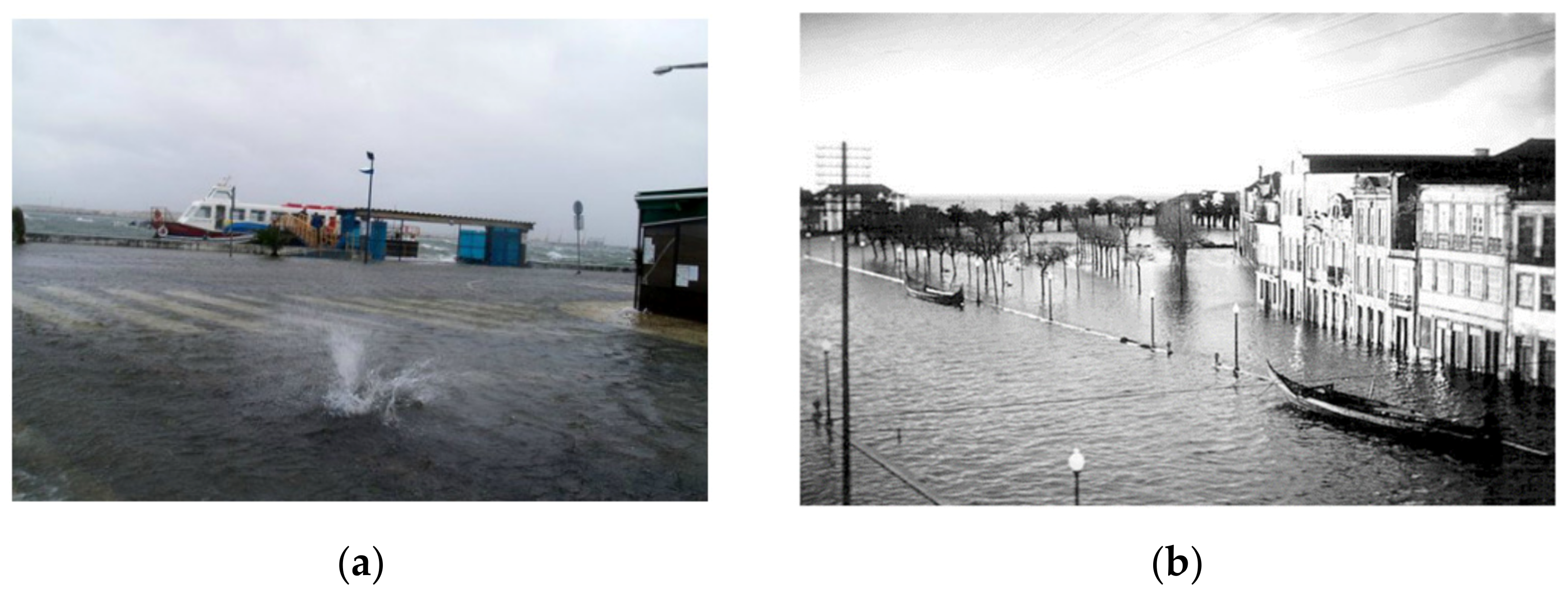
Previous research indicates that floods affect all municipalities of the region. Actually, during spring tide conditions, Estarreja, Ílhavo, Murtosa and Ovar experience regular episodes of flooding [
29]. Storm surges threaten the municipality of Aveiro in its western part (S. Jacinto) (
Figure 2a) and also in its eastern part, where the most important urban, historical and touristic center of the city is located [
30] (
Figure 2b).
Consequently, most of the lagoon marginal areas are now susceptible to extreme sea levels induced by storm surges and by the observed increase in tidal heights and mean sea level. Reference [
29] used long term tidal records, measured at the lagoon mouth, to determine the evolution of the mean sea level and found a rise at a rate of 2.2 mm/y. Using the same dataset, 208 storm surge events were observed between 1976 and 2013 at this tidal gauge [
29]. The highest storm surge occurred in 1981, with a height of 1.09 m. According to [
29], the storm surge height ranges from 0.58 to 1.17 m for the 2- and 100-year return period, respectively.
Under this context and considering that a major part of the lagoon is bordered by low lying areas, the Ria de Aveiro is highly susceptible to flood events caused by the rise in sea level resulting from climate change. For better flood risk management in the region, knowledge of the territory and the activities carried out therein is essential. According to the Land Use and Land Cover (LULC) map of 2018 (
Figure 1), the marginal regions of the Ria de Aveiro are used for agriculture (26%) and forestry (52%). The artificialized areas represent only 13% of the total area, corresponding to residential, commercial or industrial areas.
The Ria de Aveiro represents 12% of Gross Added Value (GAV) of the region, distributed as follows: 61% is assigned to the services sector, 37% corresponds to the industrial services and only 2% corresponds to the sectors of fishing, hunting, agriculture, forestry and aquaculture [
31]. Despite the low contribution to the GAV, these sectors have a fundamental role in the sustainability of the local communities [
29], especially in Murtosa municipality where this sector employs 21.5% of the population (
https://www.pordata.pt/Municipios, accessed on 1 December 2021). It should also be highlighted that the Aveiro harbor (located close to the lagoon inlet) plays a key role for the region’s economy, as it provides services to many of the regional industries [
32]. It is anticipated that by the end of the century, flooding may occur in some areas of the port due to the increase in the MSL and occurrence of storm surges, causing disturbances in its normal functioning, with important economic consequences [
33].
3. Methodology
The Delft3D-FLOW module was used to simulate the hydrodynamics of the Ria de Aveiro under different scenarios defined to research the flooding conditions under mean sea level rise and storm surge forcing. This module solves the three-dimensional equations of Navier–Stokes for incompressible fluid in shallow water and considers also Boussinesq approximations [
34].
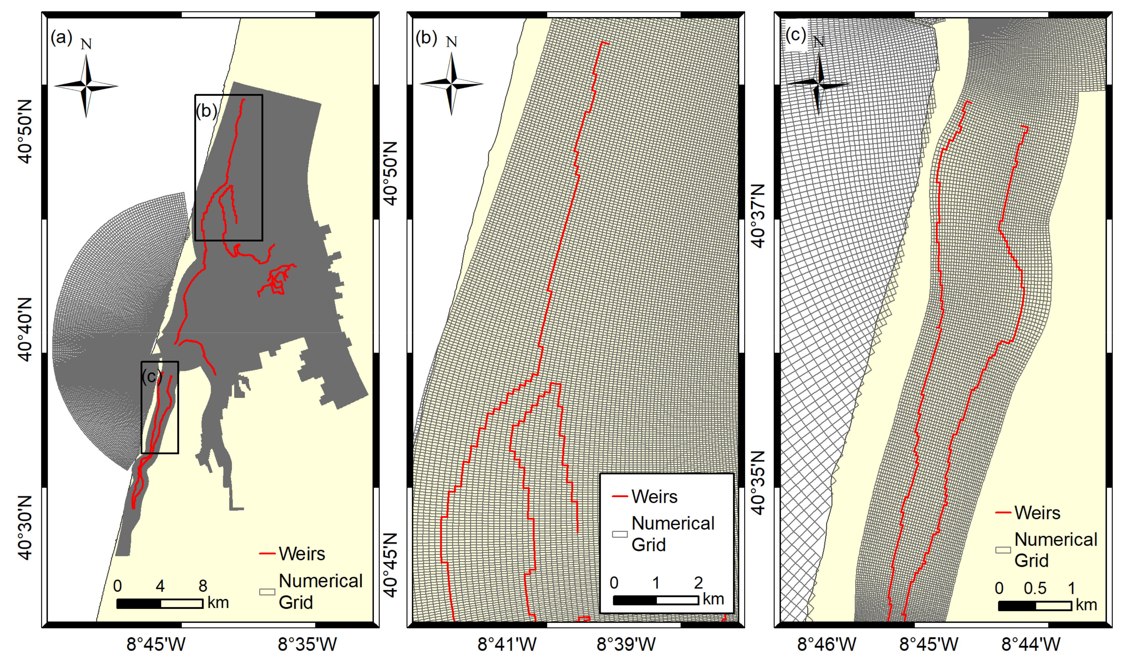
The implementation used in this study is based on a structured curvilinear grid (
Figure 3), with 477 × 1254 cells and 135,644 elements, and a variable resolution ranging between 20 and 50 m for the interior of the lagoon and 60 and 250 m for the continental shelf. The topographic and the bathymetric data used in depth interpolation for each grid element were measured in field campaigns performed between 1987 and 2012 [
21]. The topography values used in marginal regions are data measured by LIDAR and acquired in 2011 (General Directorate of the Territory (DGT)).
This implementation was previously developed and calibrated for tidal propagation and validated under storm surge events by [
20]. It was adopted as a variable coefficient of friction that is dependent on the depth of the channels, following the procedure suggested by [
35,
36]. In the marginal regions, the friction coefficient is dependent on the land use classes, following the procedure implemented in the study performed by [
21,
22], which concluded that this implementation accurately reproduces the propagation of tides and storm surges within the lagoon. In detail, Normalized Root Mean Square Errors (
NRMSE) range between 4 and 8% and skill scores are greater than 0.98 at the stations located close to the lagoon mouth and at the lagoon central area. The model accuracy decreases toward the channel’s heads, where the values of
NRMSE and skill scores vary between 11% and 26% and between 0.72 and 0.94, respectively, which is in line with the best results obtained from previous modelling efforts developed for this lagoon.
Local barriers (weirs, dams, dikes, etc.) were implemented in the model grid to prevent the inundation of protected areas (
Figure 3a), allowing the flow through the barrier only when the water level exceeds a user defined threshold level. These barriers are generally associated with roads, dikes or other infrastructures. The threshold assigned to each barrier varies between 1.5 and 3.5 m, depending on their characteristics and according to the data measured by LIDAR.
The model runs were made for 33 days and for 4 scenarios that combine different astronomical tide, mean sea level and storm surges events in the definition of the open ocean boundary condition. In detail, the model was forced at the oceanic boundary with time series obtained as the sum of astronomical tide, mean sea level and storm surge height, according to:
Sc1—Considers astronomical tidal forcing and actual mean sea level;
Sc2—Combines astronomical tidal levels and actual mean sea level with a 0.58 m height storm surge event;
Sc3—Combines astronomical tidal levels and the future mean sea level (0.63 m);
Sc4—Combines astronomical tidal levels with the future mean sea level (0.63 m) and a 0.58 m height storm surge event.
All scenarios (Sc1 to Sc4) consider the same astronomical tidal condition that was generated through harmonic synthesis using up-to-date harmonic constants that were obtained from the tidal gauge installed at the lagoon inlet. It is noteworthy that the period simulated includes an equinoctial tide to consider the occurrence of the highest sea levels.
The 0.58 m height storm surge considered corresponds to a 2-year return period event [
29]. This specific return period was chosen to identify the areas of the lagoon that may be more frequently endangered by storm surges both in the present and in the future. It is important to highlight that for the scenarios Sc2 and Sc4, the maximum storm surge height was made coincident with the maximum equinoctial tidal level.
The MSL rise considered (0.63 m) is a local projection based on the Representative Carbon Pathway (RCP) 8.5 for 2081–2100 [
29]. RCP scenarios were defined in the 5th Assessment Report (AR5) and describe different greenhouse gas emissions during the 21st century based on different socioeconomic developments [
37]. In detail, four scenarios were formulated (RCP2.6, RCP4.5, RCP6.0 and RCP8.5), where RCP8.5 is the most pessimistic, considering the highest greenhouse gas emissions throughout the 21st century. The latest IPPC report (AR6) formulated new emission scenarios (Shared Socioeconomic Pathways (SSP)) that reflect the balance between different levels of adaptation and mitigation [
38]. In this case, the SSP5-8.5 is the scenario with the highest radiative forcing as consequence of fossil-fuel based development. Despite being different, the global MSL rise projections based on RCP and SSP were revealed to be very similar [
39]. Indeed, global MSL rise projections for RCP 8.5 range between 0.49 and 0.95 m, whereas the SSP5-8.5 values range between 0.62 and 1.02 m [
39]. Considering that projections based on RCP8.5 and SPP5-8.5 are very similar, it was decided to adopt the local projection developed by [
29]. Additionally, this work focuses on the most pessimistic scenario as it represents the most serious threat arising from flood events, intending to alert authorities to the worst possible case.
Model results were analyzed, discarding the first 3 days of simulation (warm-up period). Results for scenarios Sc1 and Sc3 were analyzed together to assess the effects of the mean sea level rise in the vertical zonation through the identification of subtidal and intertidal areas, computation of mean sea surface elevation and quantification of the respective changes induced by MSL rise, to assess its impact in local habitats. Results for scenarios Sc2 and Sc4 were compared to understand the MSL rise impact on the storm surges effect in the local inundation, analyzing present and future conditions, in terms of duration of inundation and maximum sea level reached during the storm surge events, to assess their socioeconomic impact.
4. Results
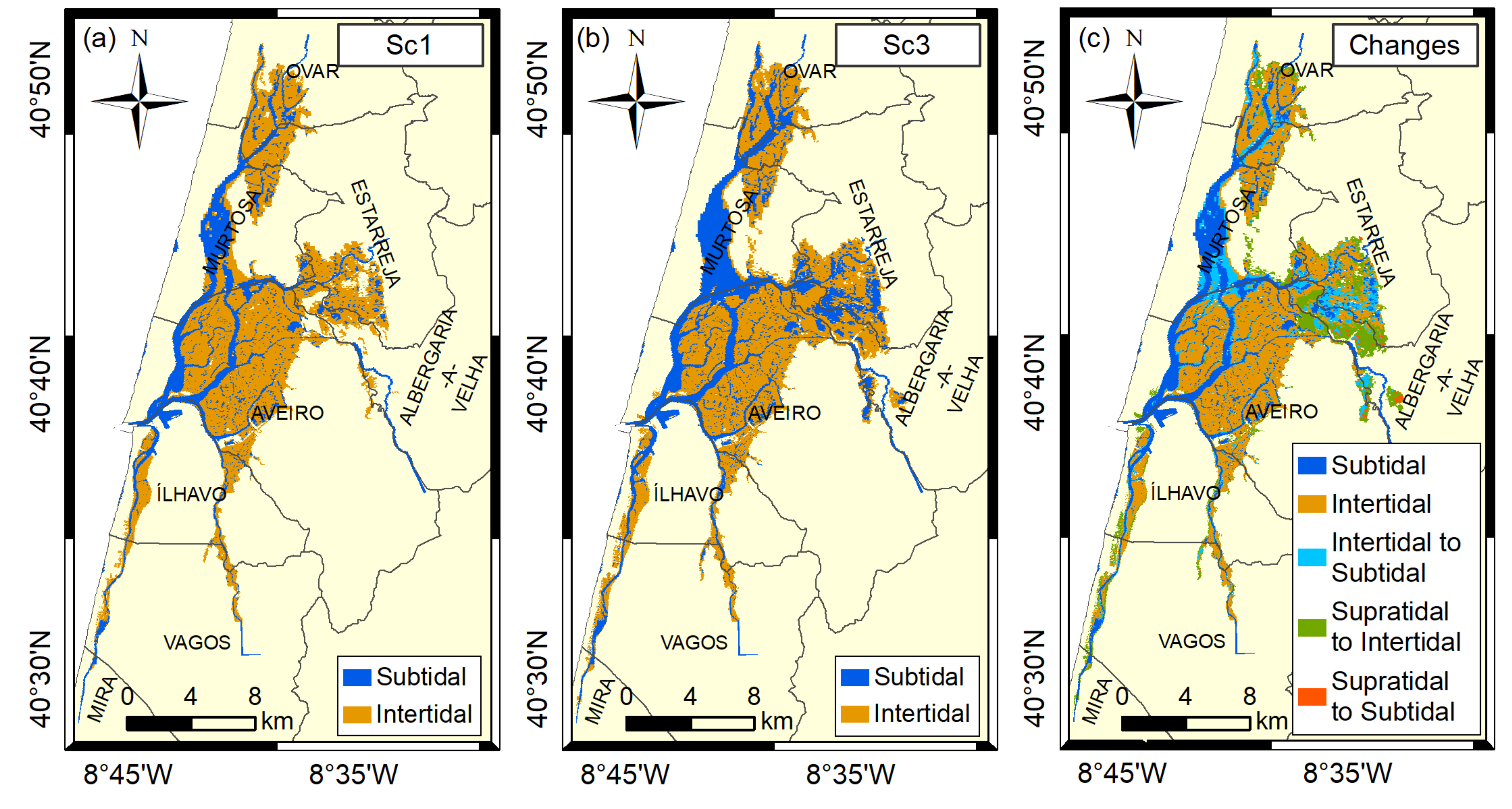
Figure 4 represents the results for the lagoon vertical zonation, through the identification of subtidal and intertidal areas for Sc1 and Sc3, as well as the changes resulting from the mean sea level rise, which were assessed comparing the differences between both scenarios. It should be noted that there were identified changes from supratidal areas, generally represented as light yellow in the Sc 1 figure, to intertidal and subtidal areas in Sc3.
Table 1 presents the areas of each environment and the respective changes. In
Figure 3c/
Table 1 (column: Changes), the subtidal and intertidal classes represent/present the areas that maintain its tidal classification, whereas the other classes refer to those experiencing vertical zonation changes.
In Sc1 (
Figure 4a), it is apparent that the subtidal regions are mainly distributed along the four main channels and through many small channels, mostly located in the middle lagoon. The intertidal regions are presented on the middle lagoon and on the channel’s margins and heads. This scenario reveals that the lagoon has a total area of 139.6 km
2, where 25% of its surface corresponds to subtidal regions, whereas 75% matches intertidal regions (35.4 and 104.2 km
2, respectively).
Similar patterns are found for Sc3 (
Figure 4b), with a major part of the subtidal regions identified in the main channels as well as along the small channels located in the central lagoon. However, the area identified for subtidal regions is much larger for this scenario comparing to Sc1, especially in the S. Jacinto channel. Moreover, some areas of the eastern part of the lagoon corresponding to subtidal regions in this scenario are completely unrelated with the main/small channels of the lagoon identified in Sc1. It should be highlighted that some of the intertidal areas under the current MSL may change to subtidal as a result of the climate change impact. Another impact might be a slight inland progression of the intertidal areas in some regions of the lagoon. Indeed, for Sc3, the subtidal area is 55.8 km
2, which represents an increase of 58% comparing to Sc1. The lagoon area increases to 160.5 km
2 (15% higher than the actual area), while the intertidal area is almost like that currently observed (104.7 km
2).
Figure 4c assesses the differences between the two scenarios, showing that the rise in the MSL might change the vertical zonation of the lagoon, flooding larger areas along the margins of the lagoon. In general, the margins of the main channels without flood protection barriers may be the most affected, with large regions changing from intertidal to subtidal (19.4 km
2) and from supratidal to intertidal (19.9 km
2). Small areas (1.0 km
2) changing from supratidal to subtidal were also identified. It should be highlighted that despite the conversion of intertidal to subtidal regions, the area of intertidal regions is kept nearly constant because the tide progression tends to occupy the adjacent margins of the lagoon. More specifically, two large areas can be considerably affected. On the one hand, as highlighted before, the eastern part of the lagoon presents large areas changing its tidal classification, corresponding to the increase in sea surface elevation and corresponding marginal flooding induced by MSL rise. In this case, the most affected municipalities may be Aveiro, Albergaria-a-Velha Estarreja and Murtosa. On the other hand, in the S. Jacinto channel margin it is apparent that another large area changes its classification from intertidal to subtidal, affecting mostly the municipality of Murtosa. Moreover, it should be highlighted that most of supratidal areas that may change to intertidal or subtidal are in the municipalities of Estarreja, Albergaria-a-Velha, Ílhavo and Vagos, which may be the most affected by the MSL rise impact.
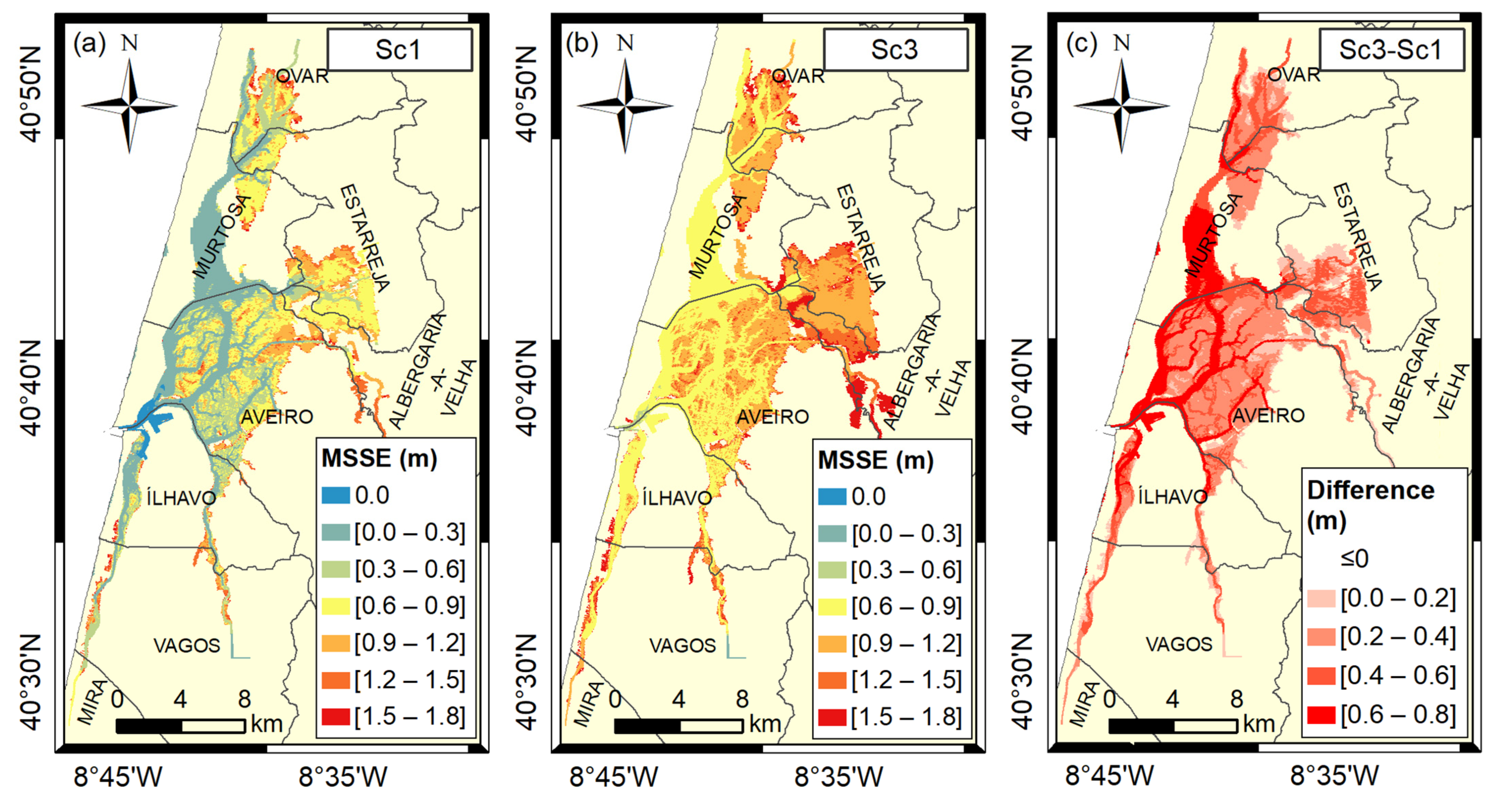
Figure 5 presents the mean sea surface elevation (MSSE) in Ria de Aveiro for Sc1 and Sc3, as well as the changes resulting from the rise in the MSL.
In Sc1 (
Figure 5a), the lowest sea surface elevation is found in the lagoon’s mouth, with values equal to 0 m. The main channels presented MSSE between 0.0 and 0.3 m, while some small channels in the middle lagoon and in the head of the channels ranged from 0.3 to 0.6 m. The large part of the intertidal region’s present values are between 0.6 and 0.9 m; however, in the head of the channels, the MSSE range from 0.9 to 1.5 m. Some restricted areas near the mouths of the rivers Cáster and Vouga reach higher values (between 1.5 and 1.8 m).
The patterns found for Sc3 (
Figure 5b) are clearly similar; however, in this case, MSSE values lower than 0.6 m are not found. Therefore, the mouth of the lagoon, the main channels and a large part of the current intertidal areas registered values between 0.6 and 0.9 m. MSSE between 0.9 and 1.5 m is identified in the middle lagoon and in some channel’s margins. In the channel’s heads values between 1.5 and 1.8 m are identified, with emphasis on a large region near the mouth of the Vouga.
The difference between the two scenarios (
Figure 5c) reveals that the main channel heads and margins show the lowest increase MSSE, with most regions ranging from 0.0 to 0.2 m. In some restricted areas there are even differences equal to or less than 0 m. For the large part of the intertidal areas, differences between 0.2 and 0.4 m are found, whereas for the most part of the main channels of the lagoon the highest difference is found, with values between 0.6 and 0.8 m, although in some regions this difference is lower, with values between 0.4 and 0.6 m.
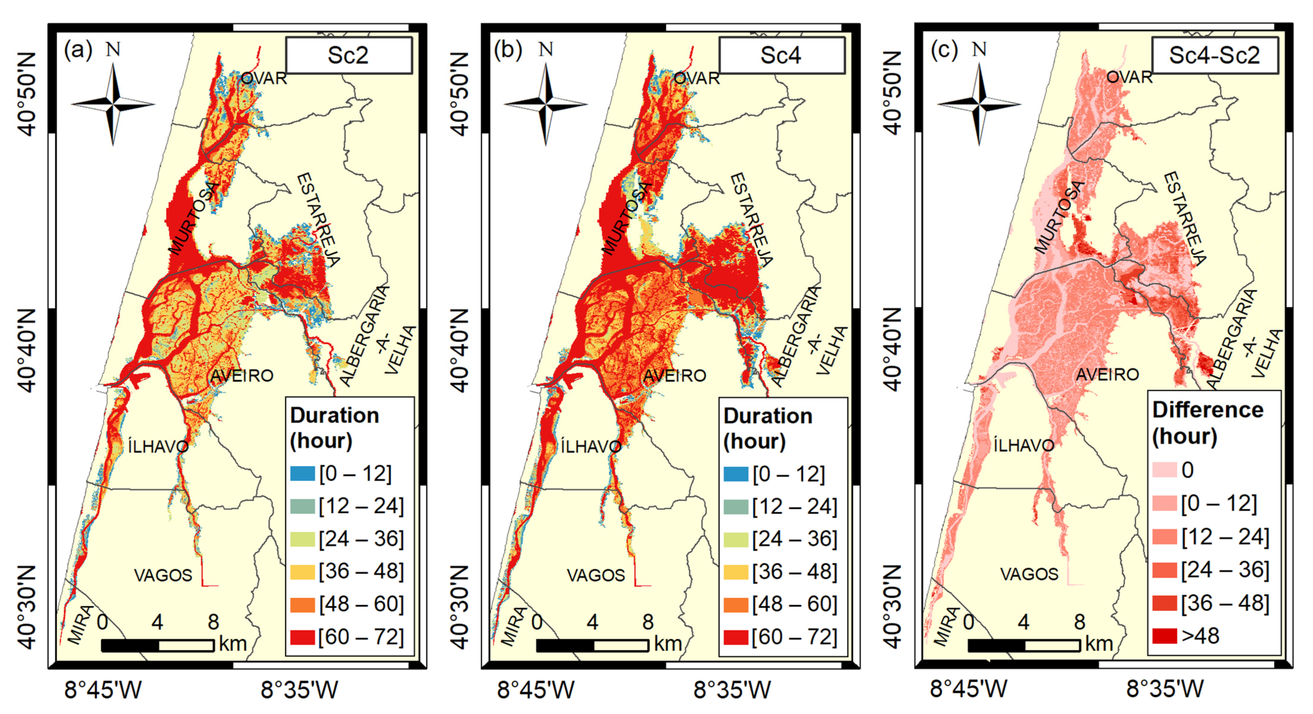
Figure 6 represents the flood duration for the Ria de Aveiro under frequent storm surges for the present (a) and future (b) MSLs.
Figure 6a, for scenario Sc2, shows that flooding at the head and margins of the main channels has a duration of mainly 0–12 or 12–24 h. On the intertidal regions, the duration of inundation is generally between 24 and 60 h. The interval of 60–72 h is evident for the main channels and some small channels located in the middle lagoon.
In the case of the Sc4 (
Figure 6b), the flood duration in response to MSL rise is longer in most parts of the lagoon. The channel’s heads and margins maintain the trend to present floods for 0–24 h; however, in this scenario, some areas are inundated during 24–36 or even 36–48 h. Intertidal regions also show an increase in flood duration. These areas experience flooding that generally lasts between 36 and 60 h, although increasing up to 60–72 h in some places. The regions of the middle and eastern part of the lagoon are two good examples of the trend mentioned. There are also some regions on the margin of the S. Jacinto channel that are only flooded in this scenario, with a long flood duration reaching 36–48 h.
The difference between the two scenarios (
Figure 6c) confirms the trends previously observed. The duration of the flood is maintained in the main channels of the lagoon, the intertidal regions register intermediate variations in the number of hours of flooding and the heads and margins of the channels present the greatest variations, mainly in the São Jacinto channel and in the eastern part of the lagoon, affecting mostly the municipalities of Albergaria-a-Velha, Aveiro, Estarreja and Murtosa.
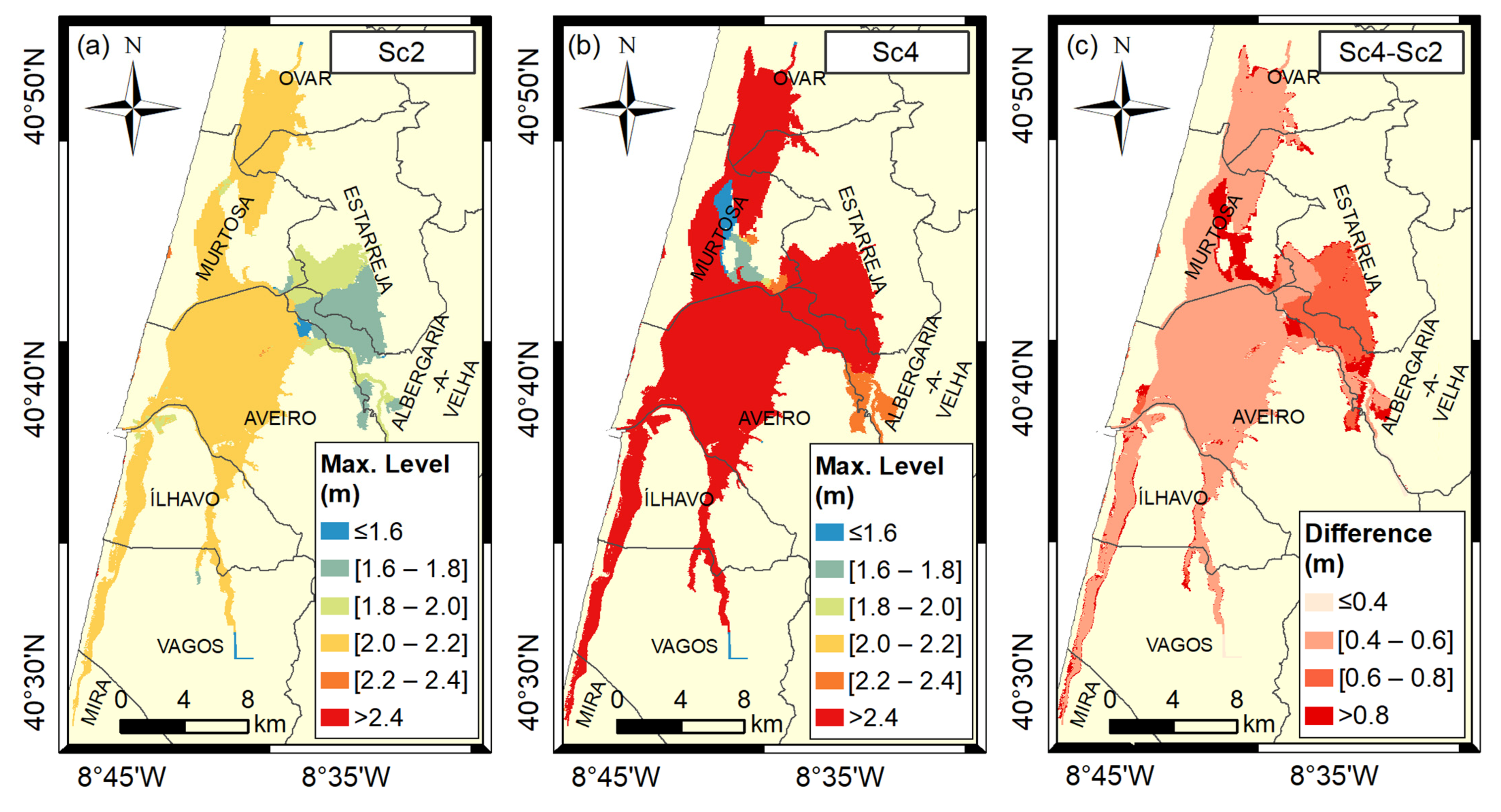
To complement the analysis of the impact of frequent storm surges in the lagoon under present and future MSL, in
Figure 7, the maximum sea surface elevation (MaxSSE) for Sc2 and Sc4 are represented, wherein Sc2 (
Figure 7a) exhibits four clearly different MaxSSE levels. The MaxSSE for most of the lagoon varies between 2.0 and 2.2 m. In contrast, the eastern part of the lagoon presents three different levels. The north region and the channel that connects the lagoon to the Vouga river present values between 1.8 and 2.0 m. The central region presents MaxSSE between 1.6 and 1.8 m, while a small region of the central lagoon registered values less than or equal to 1.6 m, the same level registered at the mouth of the Boco river.
Sc4 (
Figure 7b) also presents four different MaxSSE levels; however, in general, their values are higher. Most of the lagoon presents a MaxSSE higher than 2.4 m. The region near the Vouga river mouth and some regions in the Murtosa municipality present values between 2.2 and 2.4 m. In the municipality of Murtosa, a large region with MaxSSE between 1.6 and 1.8 m is also identified. Finally, in the margin of the S. Jacinto channel, a large area with values lower than or equal to 1.6 m is found.
The difference between the two scenarios (
Figure 7c) expresses that the margins and heads of the channels might be the most harmed regions of the lagoon due to the rise in the MSL. Most of these areas show differences higher than 0.8 m, with special attention to two large areas, one located on the eastern margin of the S. Jacinto channel, mostly affecting the municipality of Murtosa, and the other at the mouth of the Vouga, threatening the municipalities of Aveiro and Albergaria-a-Velha. The Eastern part of the lagoon also registered high differences; however, in most cases, it is lower than 0.8 m or between 0.6 and 0.8 m. In the rest and larger part of the lagoon, the difference varies between 0.4 and 0.6 m. Finally, in some small areas of the lagoon, it is equal or inferior to 0.4 m.
5. Discussion
MSL rise can negatively impact the estuaries and lagoons’ ecosystems through the increase in the MSSE and changes in the vertical zonation.
The results regarding the environmental analysis highlighted that the total intertidal area may keep constant, while the subtidal area might increase considerably, mainly due to the permanent flood of intertidal areas. The MSSE increase may be uneven for different areas of the lagoon, with lower values along the main channel heads and margins and higher values for the intertidal areas and main channels of the lagoon.
These modifications may be especially harmful to the intertidal areas that, in general, are occupied by mudflats and salt marshes. On the one hand, when these regions change to subtidal, these habitats tend to disappear, making it impossible for several species to survive in the new conditions, as showed by [
40]. On the other hand, the general increase in the MSSE on the intertidal areas and salt marshes can indirectly affect the local vegetation, since their roots will possibly be flooded during longer periods and consequently less oxygenated, which, according to previous studies [
19,
40], may have adverse consequences on the salt marsh extent and, therefore, on the local ecosystems.
Changes on salt marshes extent might have impacts at various levels [
41]. highlighted the role of salinity in reducing nutrient concentration and identified that the rise in MSL can lead to the destruction of these areas and increase the flow of organic C and N from the lagoon to the coastal shelf, which may reduce the risk of eutrophication inside the lagoon and increase the secondary production on the shelf. MSL rise may also impact aquaculture productivity, which, in the Ria de Aveiro, is essentially dedicated to the production of bivalves and fish, although [
42] demonstrated that this lagoon is more suitable to produce fish. It is anticipated that the increase in MSL will favor this trend due to the increase in subtidal areas, more suitable for fish production. Besides, [
43] found that saltmarshes act as natural buffer zones, providing protection against storms and flooding, so that their displacement/relocation could endanger the marginal areas of the Ria de Aveiro. This threat is particularly important considering that large areas of marshes have degraded or disappeared in recent decades, diminishing the system’s natural protection against flooding.
The Murtosa municipality can be the most harmed by the change in the vertical zonation, with important areas transferred from intertidal to subtidal. The change from supratidal to intertidal could mainly affect the municipalities of Albergaria-a-Velha, Aveiro and Estarreja, besides the margins and heads of every lagoon channel. However, as MSL increases slowly, local authorities may have time to protect those parts of the territory if acting based on existing scientific information and local predictions.
The findings described agree with previous studies for the Ria de Aveiro [
16,
27,
29]. However, this study is the first highlighting that the municipality of Murtosa is the most affected. Changes in vertical zonation, habitat type and MSSE predicted for the Ria de Aveiro are also in line with findings resulting from studies performed for other ecosystems. For example, in the Bangladesh Sundarbans, it is expected that by the year 2070 there may be no suitable habitats for the Bengal tiger due to MSL rise [
44]. In the Venice lagoon, the salt marsh vegetation could disappear by the end of the century and therefore the reshaping of the local coastal habitats is expected [
45]. Moreover, MSL rise must also reduce the beach areas around the world [
46] and, therefore, important habitats for many species might be at risk [
47]. Additionally, a recent study about the Taf Estuary reveals that certain saltmarsh changes can have widespread impacts on the local hydrodynamics [
48] that, in turn, may change the vertical zonation, the MSSE distribution and the storm surge propagation in unexpected ways. Therefore, the results obtained in this study can be analyzed in the context of other similar systems, bringing new insights to the comprehension of their future behavior in a climate change context.
Regarding the changes that MSL rise may induce in the storm surges impact in Ria de Aveiro, the large increase on duration of inundation is expected for the heads and margins of the channels and might mostly affect the municipalities of Albergaria-a-Velha, Aveiro, Estarreja and Murtosa. In all of them, the large part of the flooded area corresponds to agricultural areas, so losses for the sector are expected for the future as these areas may be inundated by salt water, dictating the failure of the crops. This fact is especially important to the Murtosa municipality since agriculture represents the most employing sector. East of Aveiro, the inundation can even extend to artificialized surfaces, which may force the local authorities to act to protect its value.
In the western part of the municipality, there is a small parish (São Jacinto) where the duration of the flood foreseen for the future during the passage of a storm surge may be much longer. This small parish presents a population of only 993 people and a populational density of 71.6 hab/km
2 (
https://www.jf-saojacinto.pt/caracterizacao, accessed on 1 December 2021). These numbers are misleading, as the population lives in a restricted area with a significant population density, as most of the territory is occupied by a military base and nature reserve. This way, the flood extent occurs on the downtown parish, characterized by a residential and commercial center. Therefore, this is the region of higher risk in all the lagoon territory, as it can cause material or economic losses or, in the worst case, life losses.
If storm surges with a higher return period (and higher surge heights) were considered in this study, the results would be slightly different. Although the areas flooded under these events will be mostly the same, as well as the flood duration, the flood extent would be higher. This will represent a higher risk for the regions affecting the populations and activities, but these cases correspond to more uncommon events, which consideration would bring a higher and unjustified alarmism.
Maximum sea surface elevation presents similar values for both scenarios under analysis for most of the lagoon area. However, the eastern part of the lagoon shows lower elevations for the present sea level and higher elevations for the future. This fact can be explained by the low quota in this area, which, with the increase in the MSL, makes the action of the storm surge to be negligible. Another difference occurs in the new flooded areas, which, nowadays, do not have maximum values (because they do not flood). However, in the future, they may present values lower than most of the lagoon, due to its larger quota. Most of these are agricultural areas in the Murtosa municipality and therefore their flooding has a significant socioeconomical impact. The analysis of the difference between the two scenarios also reveals that the channel’s heads and margins are the most affected areas. Most of these are used for agriculture; however, as previously referred, in the São Jacinto parish, MSL rise can also damage residential areas and commercial establishments. Following these results, it is expected that, by the end of the century, under frequent storm surges events, the São Jacinto downtown could reach maximum levels higher than 2.4 m. Considering an average elevation of 2.0 m for the region, the water column may be higher than 0.4 m, which can be very dangerous for animals, children or people with less mobility, and cause damage to homes, businesses or other infrastructures.
These findings are in agreement with those presented by [
49]; however, these authors identified a large area in the Ílhavo municipality with high flood risk that was not found in this study. This divergence results from the implementation of a defense structure against floods in the model used in this study, contrary to the situation analyzed by the aforementioned authors. This way, the present study identifies the agricultural areas as the most endangered in the future, followed by some artificialized areas, as previously identified by [
16,
29] for this study area. Results for other case studies also highlighted tourism as a socioeconomic activity threatened by rising sea levels [
50,
51], which may also occur in the Ria de Aveiro, as this sector has been growing rapidly in the region due to the unique characteristics of this ecosystem in the country. Other studies have also revealed impacts of the MSL rise on oyster production [
52,
53], which is another activity with emerging economic importance in the intertidal regions of the lagoon and which, therefore, could also be threatened in the future.
Coastal systems generally have a high sedimentary dynamic and, in some cases, sedimentary accretion can overcome the MSL rise rate, making the system resilient to climate change and less vulnerable to floods [
54,
55]. The Ria the Aveiro has a very complex morphology, frequently shaped by human actions, and therefore it is impossible to predict its future configuration. However, a recent study [
16] concluded that the lagoon deepened since 1987, because of dredging activities performed in the late 1990s and due to the ebb dominance of the inlet and central lagoon area, that promotes sediments exportation from these areas to the adjacent ocean. In turn, [
19] verified that the salt marshes of the lagoon have been degraded mainly after the lagoon deepening. These findings suggest that future inundation extents can be even higher than those projected in this study if this evolutionary trend continues in the future.
Considering that flood extent highly depends on the coastal region geomorphology and that numerical models have the capacity to forecast the inundation extent under different system configurations, future studies should be conducted in strong cooperation with local authorities to evaluate the effectiveness of realistic protection barriers in minimizing the consequences of flood events. In addition, it is recommended to consider possible system geomorphologies for the future that result from knowledge of local sedimentary rates, when available.
Finally, it should be noted that MSL rise, for itself, is not a severe threat to people or even to economic activities in Ria de Aveiro, as it is a slow process that gives local authorities time to define measures to adapt or protect the territory. However, ecological aspects are often forgotten, and these can have a strong impact on natural flood protection structures in the future. Discordantly, its joint effect with storm surges can have strong ecological and socioeconomic consequences, as the rise in the MSL amplifies the adverse impacts of storm surges. In this context, it should be highlighted that the connection between science and the population has a key role on the success of coastal protection politics [
56]. On the one hand, the scientists must be able to listen to the opinions of the local communities about possible strategies and solutions to climate change prevention and mitigation and, simultaneously, should be able to explain the expected hazards and the impacts of the different proposals, especially to younger generations. On the other hand, the local communities can voluntarily provide useful information to help the calibration of the models or carry out monitoring of the extent of salt marshes and/or flood extent. Thus, promoting the involvement of the population with science and decision makers significantly increases the probability of success of measures to be implemented to increase coastal protection from climate threats.
6. Conclusions
The present study revealed that the MSL rise may change the current flooding patterns of a mesotidal lagoon, impacting its ecological and socioeconomic status. The rise in mean sea level may modify the current vertical zonation, changing the future extent of the supratidal and intertidal regions which, in many cases, might become intertidal and subtidal regions, respectively. The MSSE may also increase in the future, with higher values in the main channels, average in intertidal areas and lower in the channel’s heads. These changes should affect local habitats, with consequences for many species and for the economy of the region, as several of the future intertidal areas are, nowadays, agricultural fields. The predicted loss of intertidal areas can also have a strong impact on future flooding in the lagoon due to the loss of its value as a coastal protection. This way, marginal areas of Ria de Aveiro might become more vulnerable to flood risk in the future.
The inundation patterns of the lagoon may also change in the future in response to MSL rise, as the flood extent caused by a 2-year return period storm surge will probably be higher. Its main effect might be the flooding of new areas, where the duration of inundation and the maximum sea surface elevation can be significant. The intertidal areas may also be damaged in response to the increase in maximum sea surface elevation and the duration of inundation, which may increase considerably in these regions.
Flood patterns show a drastic increase in the vulnerability of the Ria de Aveiro in response to storm surges at higher MSL conditions. Agriculture will probably be the most threatened socioeconomic sector as, in the future, the extent of floods may reach the lagoon’s marginal areas mostly dedicated to this activity. In some areas of the lagoon, future inundation patterns can also endanger residential areas, mainly in the São Jacinto parish, in the municipality of Aveiro.
Finally, Albergaria-a-Velha, Aveiro, Estarreja and Murtosa might be the municipalities most threatened by MSL rise, although changes in the inundation patterns may also occur in the margins of the channels located in each municipality. This way, an intermunicipal strategy should be prepared to protect the territory and the ecosystem for the changes predicted in the future that may mainly harm agricultural fields but, in the case of extreme frequent events, may also put lives and property at risk.
This study provides useful information for making informed decisions on the selection and implementation of management intervention scenarios for mesotidal lagoons and estuaries. However, it is important to extend the investigations to other similar coastal systems to gain insights into the context dependency of these impacts.


 ,
, 


