
Natural Processes and Anthropogenic Activity in the Indus River Sedimentary Environment in Pakistan: A Critical Review


 , , and
Abstract
:1. Introduction
2. Geological Setting
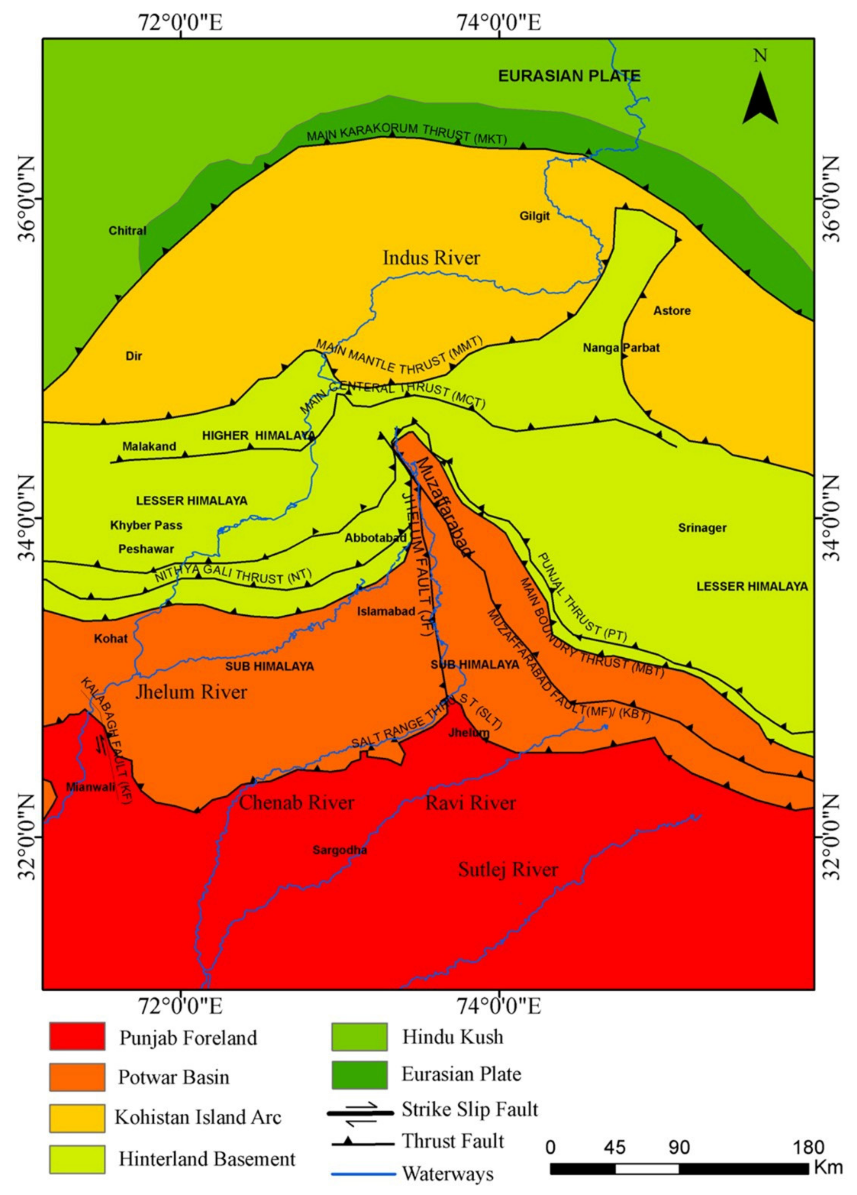
2.1. Geotectonic Framework
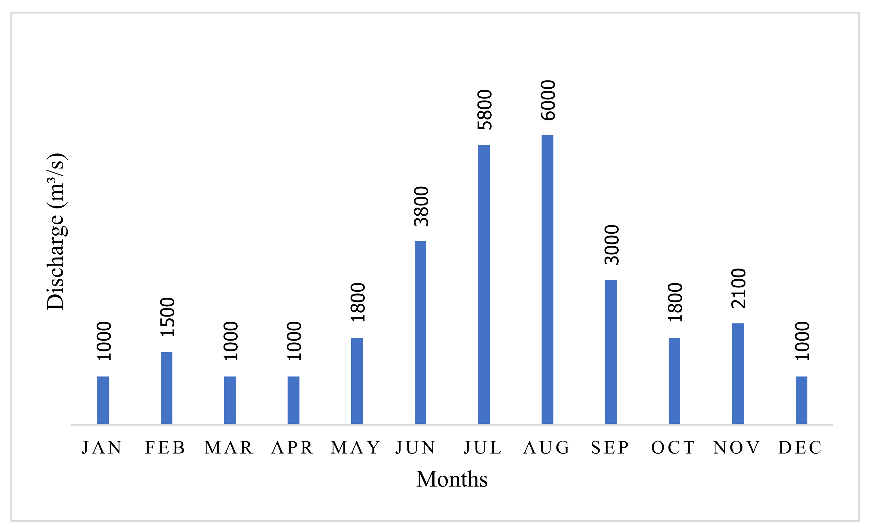
2.2. Seasonal Controls on Hydrological Variability
2.3. Volumes of Sediment Eroded within the Upper Indus
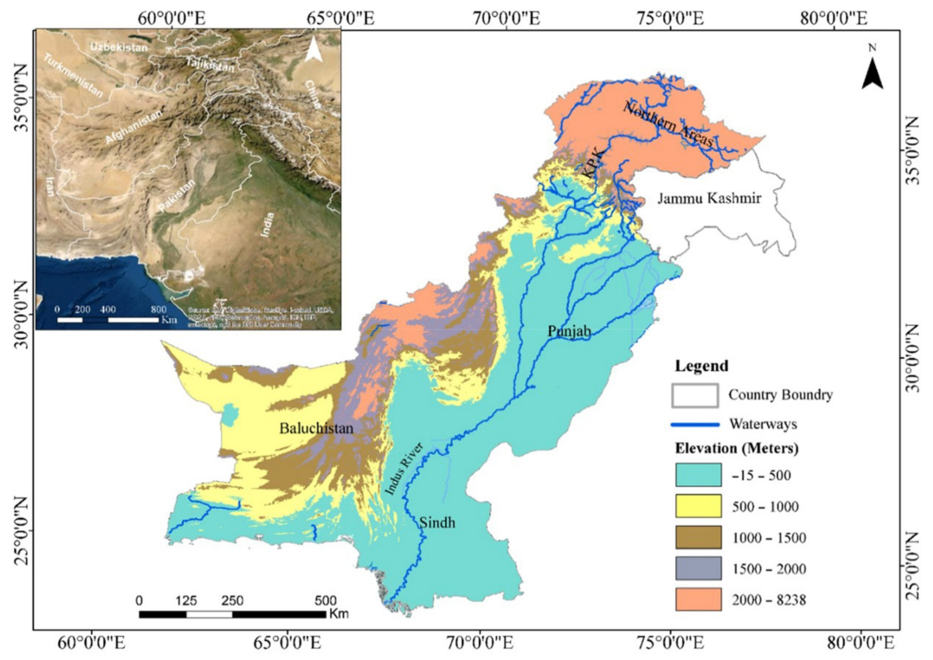
3. Study Area
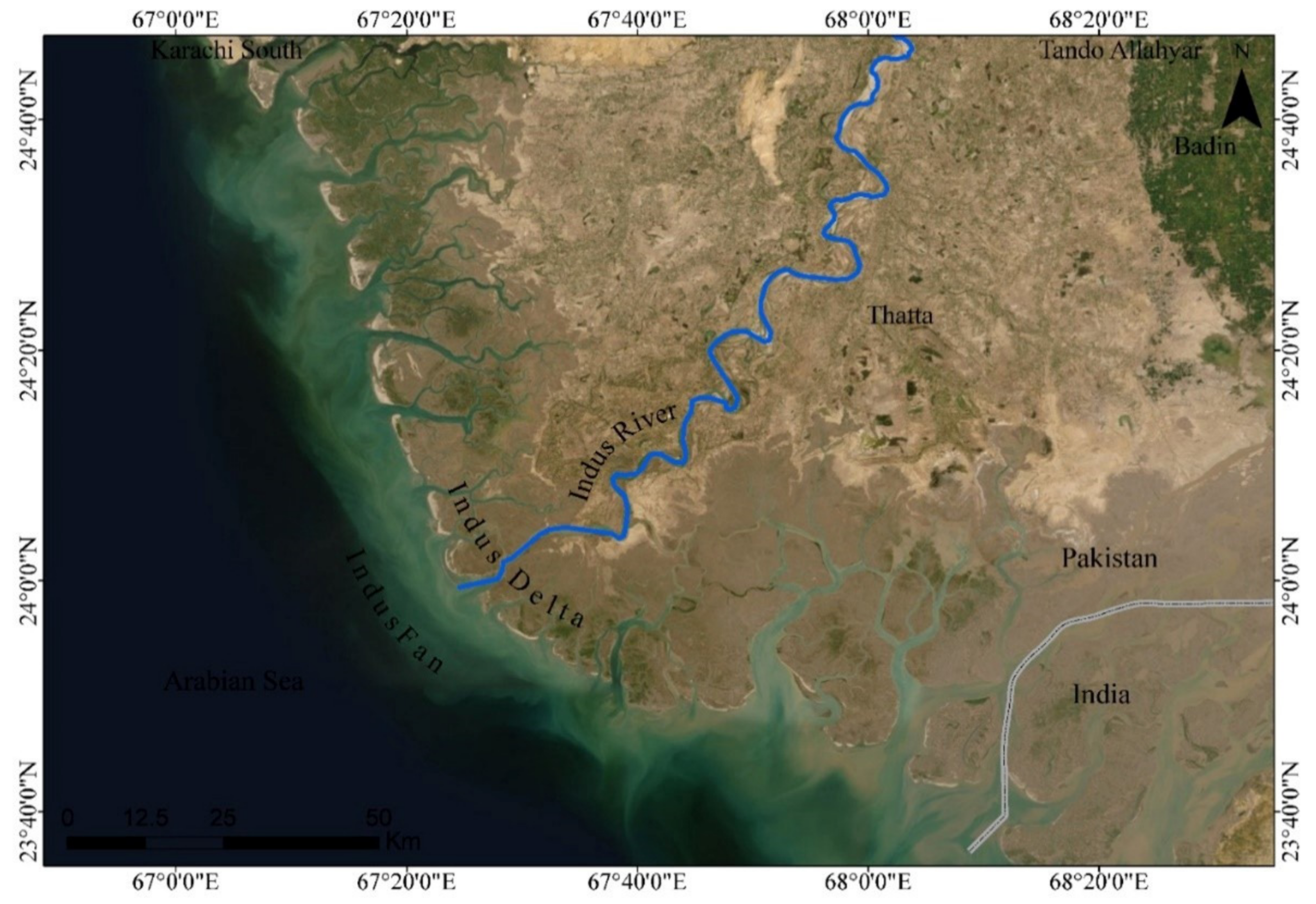
3.1. The Indus Fan
3.2. Upper Indus Basin
4. Environmental Conditions of the Sedimentary Indus River System
4.1. West–East Climate and Topographic Contrasts
4.2. Sedimentary Processes and Characteristics of the Indus River
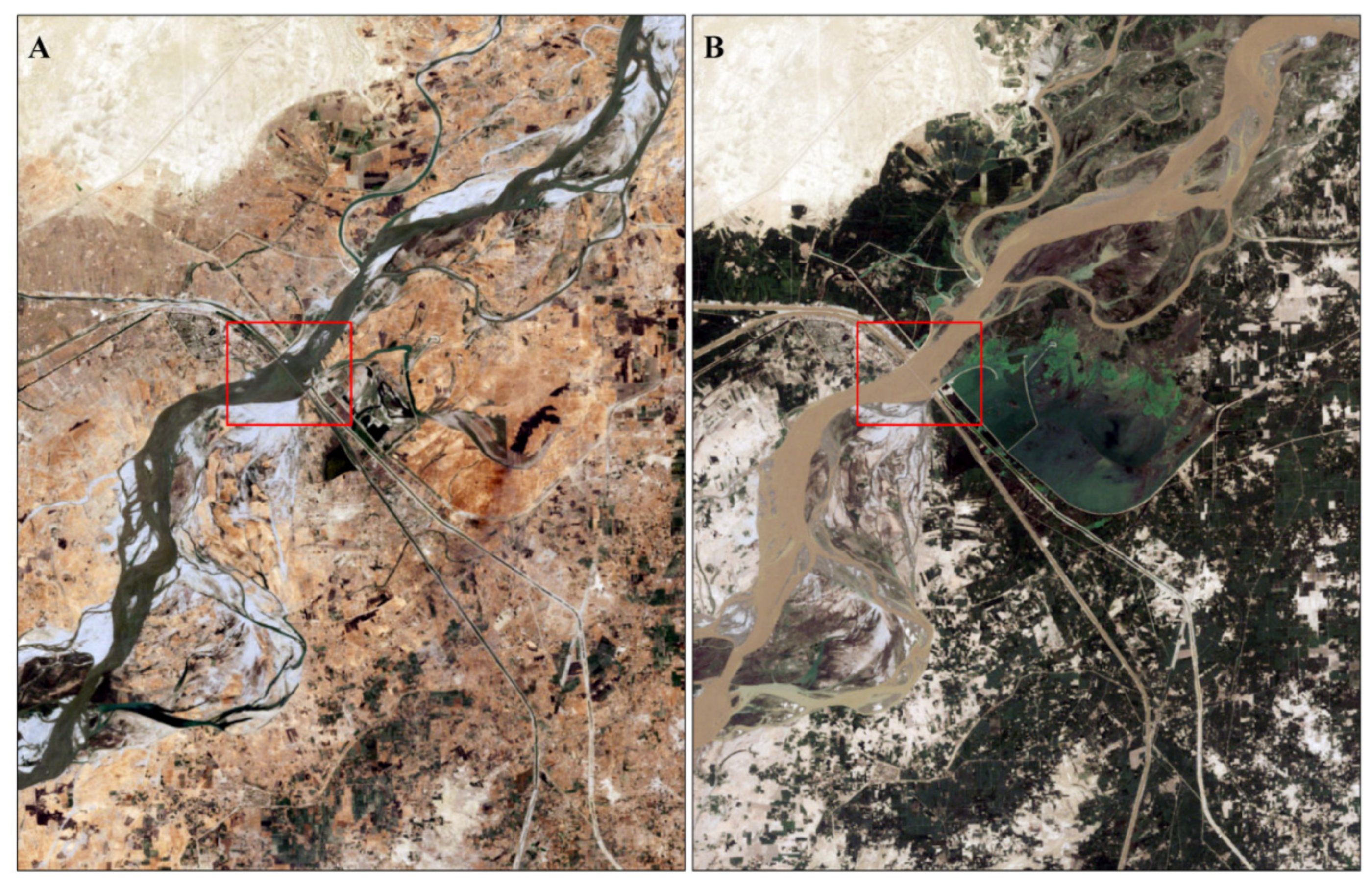
4.3. Traveling Path of Sediments
4.4. Source to Sink Transport of Sediment
5. Anthropogenic Activity across the Indus River
5.1. Key Drivers
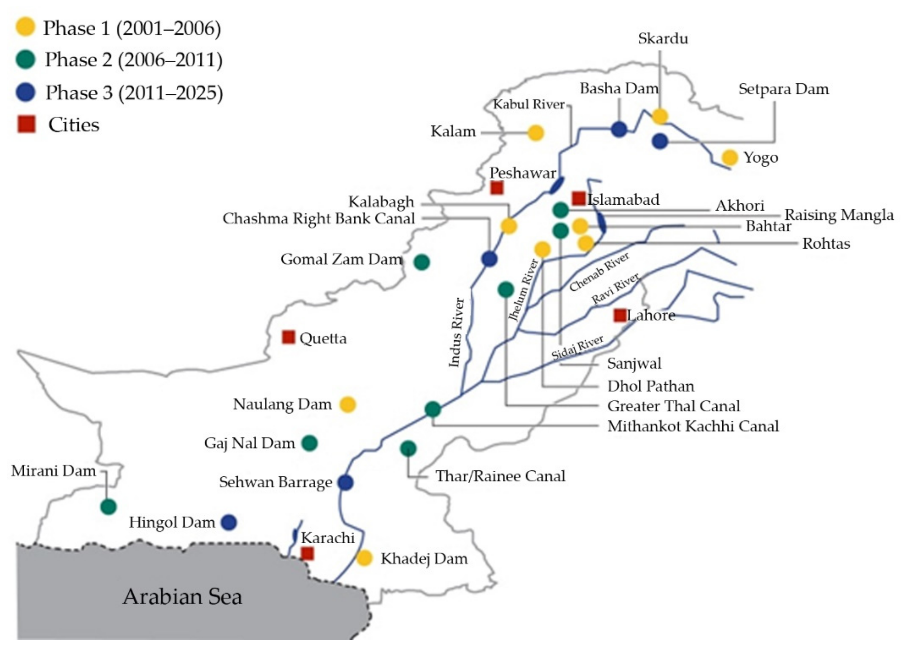
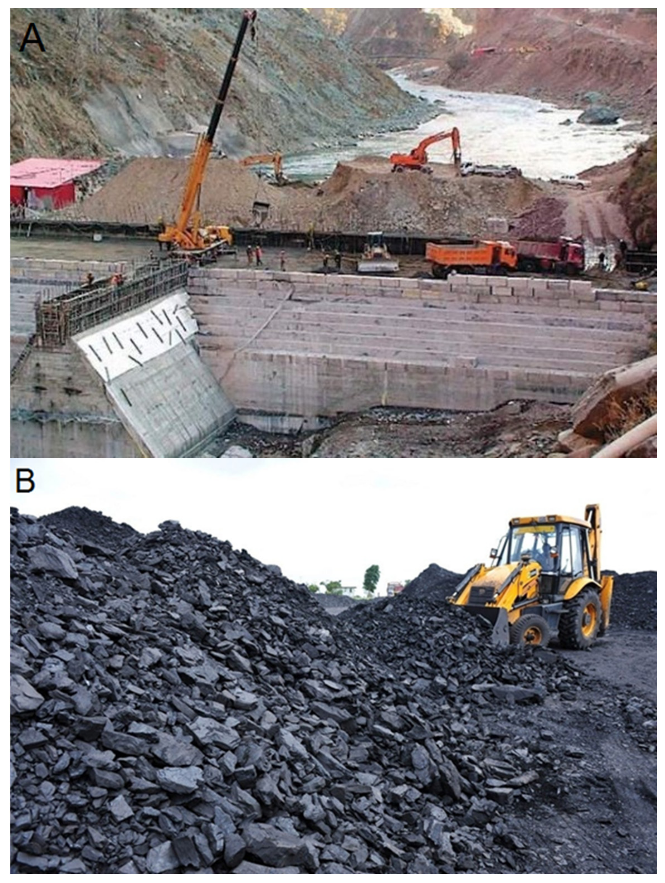
5.1.1. Dam Construction
5.1.2. Land Clearance and Catchment Disturbance
5.1.3. Coal Mining Influence on Central Indus Basin
5.2. Physical versus Chemical Changes in Indus River Sediments
6. Influence of Natural and Anthropogenic Factors on Hydrogeology
7. Conclusions
Author Contributions
Funding
Institutional Review Board Statement
Informed Consent Statement
Conflicts of Interest
References
- Ahmed, W.; Wu, Y.; Kidwai, S.; Li, X.; Zhang, G.; Zhang, J. Spatial and temporal variations of nutrients and chlorophyll a in the Indus River and its deltaic creeks and coastal waters (Northwest Indian Ocean, Pakistan). J. Mar. Syst. 2021, 218, 103525. [Google Scholar] [CrossRef]
- Wang, M.; Tang, T.; Burek, P.; Havlík, P.; Krisztin, T.; Kroeze, C.; Leclère, D.; Strokal, M.; Wada, Y.; Wang, Y. Increasing nitrogen export to sea: A scenario analysis for the Indus River. Sci. Total Environ. 2019, 694, 133629. [Google Scholar] [CrossRef] [PubMed] [Green Version]
- Sanyal, S. The Ocean of Churn: How the Indian Ocean Shaped Human History; Penguin: London, UK, 2016. [Google Scholar]
- Inam, A.; Clift, P.D.; Giosan, L.; Tabrez, A.R.; Tahir, M.; Rabbani, M.M.; Danish, M. The geographic, geological and oceanographic setting of the Indus River. In Large Rivers: Geomorphology and Management; John Wiley & Sons, Ltd.: Chichester, UK, 2007; pp. 333–345. [Google Scholar]
- Karim, A.; Veizer, J. Water balance of the Indus River Basin and moisture source in the Karakoram and western Himalayas: Implications from hydrogen and oxygen isotopes in river water. J. Geophys. Res. Atmos. 2002, 107, ACH 9-1–ACH 9-12. [Google Scholar] [CrossRef]
- Lee, J.I.; Clift, P.D.; Layne, G.; Blum, J.; Khan, A.A. Sediment flux in the modern Indus River inferred from the trace element composition of detrital amphibole grains. Sediment. Geol. 2003, 160, 243–257. [Google Scholar] [CrossRef]
- Clift, P.D. A brief history of the Indus River. Geol. Soc. Lond. Spec. Publ. 2002, 195, 237–258. [Google Scholar] [CrossRef]
- Alizai, A.; Carter, A.; Clift, P.D.; VanLaningham, S.; Williams, J.C.; Kumar, R. Sediment provenance, reworking and transport processes in the Indus River by U–Pb dating of detrital zircon grains. Glob. Planet. Chang. 2011, 76, 33–55. [Google Scholar] [CrossRef]
- Hall, R.; Cottam, M.A.; Wilson, M.E. The SE Asian gateway: History and tectonics of the Australia–Asia collision. Geol. Soc. Lond. Spec. Publ. 2011, 355, 1–6. [Google Scholar] [CrossRef] [Green Version]
- Fielding, C.R.; Gupta, A. Sedimentology and stratigraphy of large river deposits: Recognition in the ancient record, and distinction from “incised valley fills”. In Large Rivers: Geomorphology and Management; John Wiley & Sons, Ltd.: Chichester, UK, 2007; pp. 97–113. [Google Scholar]
- Clift, P.D.; Zheng, H.; Carter, A.; Böning, P.; Jonell, T.N.; Schorr, H.; Shan, X.; Pahnke, K.; Wei, X.; Rittenour, T. Controls on erosion in the western Tarim Basin: Implications for the uplift of northwest Tibet and the Pamir. Geosphere 2017, 13, 1747–1765. [Google Scholar] [CrossRef] [Green Version]
- Pickering, K.T.; Carter, A.; Andò, S.; Garzanti, E.; Limonta, M.; Vezzoli, G.; Milliken, K.L. Deciphering relationships between the Nicobar and Bengal submarine fans, Indian Ocean. Earth Planet. Sci. Lett. 2020, 544, 116329. [Google Scholar] [CrossRef]
- Bastia, R.; Das, S.; Radhakrishna, M. Pre-and post-collisional depositional history in the upper and middle Bengal fan and evaluation of deepwater reservoir potential along the northeast Continental Margin of India. Mar. Pet. Geol. 2010, 27, 2051–2061. [Google Scholar] [CrossRef]
- Macklin, M.G.; Lewin, J. The rivers of civilization. Quat. Sci. Rev. 2015, 114, 228–244. [Google Scholar] [CrossRef]
- Bhattacharyya, K. The Lower Damodar River, India: Understanding the Human Role in Changing Fluvial Environment; Springer Science & Business Media: New York, NY, USA, 2011. [Google Scholar]
- Angelakis, A.N.; Asano, T.; Bahri, A.; Jimenez, B.E.; Tchobanoglous, G. Water reuse: From ancient to modern times and the future. Front. Environ. Sci. 2018, 6, 26. [Google Scholar] [CrossRef] [Green Version]
- Marks, R.B. The Origins of the Modern World: A Global and Environmental Narrative from the Fifteenth to the Twenty-First Century; Rowman & Littlefield: New York, NY, USA, 2019. [Google Scholar]
- Eqani, S.A.M.A.S.; Kanwal, A.; Bhowmik, A.K.; Sohail, M.; Ullah, R.; Ali, S.M.; Alamdar, A.; Ali, N.; Fasola, M.; Shen, H. Spatial distribution of dust–bound trace elements in Pakistan and their implications for human exposure. Environ. Pollut. 2016, 213, 213–222. [Google Scholar] [CrossRef] [PubMed]
- Zia, A.; Wagner, C.H. Mainstreaming early warning systems in development and planning processes: Multilevel implementation of Sendai framework in Indus and Sahel. Int. J. Disaster Risk Sci. 2015, 6, 189–199. [Google Scholar] [CrossRef] [Green Version]
- Debnath, J.; Ahmed, I.; Pan, N.D. Impact of anthropogenic activities on channel characteristics: A case study of Muhuri River, Tripura, North-East India. Arch. Appl. Sci. Res. 2015, 7, 27–36. [Google Scholar]
- Huang, M.-W.; Liao, J.-J.; Pan, Y.-W.; Cheng, M.-H. Rapid channelization and incision into soft bedrock induced by human activity—Implications from the Bachang River in Taiwan. Eng. Geol. 2014, 177, 10–24. [Google Scholar] [CrossRef]
- Roy, S. Impact of linear transport infrastructure on fluvial connectivity across the catchments of West Bengal, India. Geocarto Int. 2021, 1–26. [Google Scholar] [CrossRef]
- Syvitski, J.P.; Kettner, A.J.; Overeem, I.; Giosan, L.; Brakenridge, G.R.; Hannon, M.; Bilham, R. Anthropocene metamorphosis of the Indus Delta and lower floodplain. Anthropocene 2013, 3, 24–35. [Google Scholar] [CrossRef]
- Sohail, M.T.; Delin, H.; Siddiq, A.; Idrees, F.; Arshad, S. Evaluation of historic Indo-Pak relations, water resource issues and its impact on contemporary bilateral affairs. Asia Pac. J. Multidiscip. Res. 2015, 3, 48–55. [Google Scholar]
- Petrie, C.A.; Orengo, H.A.; Green, A.S.; Walker, J.R.; Garcia, A.; Conesa, F.; Knox, J.R.; Singh, R.N. Mapping archaeology while mapping an empire: Using historical maps to reconstruct ancient settlement landscapes in modern India and Pakistan. Geosciences 2019, 9, 11. [Google Scholar] [CrossRef] [Green Version]
- Yang, Y.-C.E.; Brown, C.; Yu, W.; Wescoat Jr, J.; Ringler, C. Water governance and adaptation to climate change in the Indus River Basin. J. Hydrol. 2014, 519, 2527–2537. [Google Scholar] [CrossRef] [Green Version]
- Shaheen, F.; Shah, F.A. Climate Change, Economic Growth, and Cooperative Management of Indus River Basin. In Proceedings of the 2017 Agricultural & Applied Economics Association Annual Meeting, Chicago, IL, USA, 30 July–1 August 2017. [Google Scholar]
- Usman, Q.A.; Muhammad, S.; Ali, W.; Yousaf, S.; Jadoon, I.A. Spatial distribution and provenance of heavy metal contamination in the sediments of the Indus River and its tributaries, North Pakistan: Evaluation of pollution and potential risks. Environ. Technol. Innov. 2021, 21, 101184. [Google Scholar] [CrossRef]
- Hester, E.T.; Doyle, M.W. Human impacts to river temperature and their effects on biological processes: A quantitative synthesis 1. JAWRA J. Am. Water Resour. Assoc. 2011, 47, 571–587. [Google Scholar] [CrossRef]
- Al-Ghanim, K.; Mahboob, S.; Seemab, S.; Sultana, S.; Sultana, T.; Al-Misned, F.; Ahmed, Z. Monitoring of trace metals in tissues of Wallago attu (lanchi) from the Indus River as an indicator of environmental pollution. Saudi J. Biol. Sci. 2016, 23, 72–78. [Google Scholar] [CrossRef] [Green Version]
- Tsering, T.; Sillanpää, M.; Sillanpää, M.; Viitala, M.; Reinikainen, S.-P. Microplastics pollution in the Brahmaputra River and the Indus River of the Indian Himalaya. Sci. Total Environ. 2021, 789, 147968. [Google Scholar] [CrossRef]
- Westerweel, J.; Roperch, P.; Licht, A.; Dupont-Nivet, G.; Win, Z.; Poblete, F.; Ruffet, G.; Swe, H.H.; Thi, M.K.; Aung, D.W. Burma Terrane part of the Trans-Tethyan arc during collision with India according to palaeomagnetic data. Nat. Geosci. 2019, 12, 863–868. [Google Scholar] [CrossRef]
- Henderson, A.L.; Najman, Y.; Parrish, R.; BouDagher-Fadel, M.; Barford, D.; Garzanti, E.; Andò, S. Geology of the Cenozoic Indus Basin sedimentary rocks: Paleoenvironmental interpretation of sedimentation from the western Himalaya during the early phases of India-Eurasia collision. Tectonics 2010, 29. [Google Scholar] [CrossRef] [Green Version]
- Wang, E. Timing of the initial collision between the Indian and Asian continents. Sci. China Earth Sci. 2017, 60, 626–634. [Google Scholar] [CrossRef]
- Hu, X.; Wang, J.; An, W.; Garzanti, E.; Li, J. Constraining the timing of the India-Asia continental collision by the sedimentary record. Sci. China Earth Sci. 2017, 60, 603–625. [Google Scholar] [CrossRef]
- Khan, M.; Liu, Y. Geodynamic evolution of the offshore Indus Basin Pakistan: The western Indian plate passive continental margin. Geophys. J. Int. 2019, 217, 1366–1386. [Google Scholar] [CrossRef]
- Ali, J.R.; Aitchison, J.C. Gondwana to Asia: Plate tectonics, paleogeography and the biological connectivity of the Indian sub-continent from the Middle Jurassic through latest Eocene (166–35 Ma). Earth-Sci. Rev. 2008, 88, 145–166. [Google Scholar] [CrossRef]
- Aitchison, J.C.; Ali, J.R.; Davis, A.M. When and where did India and Asia collide? J. Geophys. Res. Solid Earth 2007, 112, B05423. [Google Scholar] [CrossRef] [Green Version]
- Chatterjee, S.; Bajpai, S. India’s northward drift from Gondwana to Asia during the Late Cretaceous-Eocene. Proc. Indian Natl. Sci. Acad. 2016, 82, 479–487. [Google Scholar] [CrossRef]
- Kohn, M.J.; Paul, S.K.; Corrie, S.L. The lower Lesser Himalayan sequence: A Paleoproterozoic arc on the northern margin of the Indian plate. Bulletin 2010, 122, 323–335. [Google Scholar] [CrossRef] [Green Version]
- Chatterjee, S.; Goswami, A.; Scotese, C.R. The longest voyage: Tectonic, magmatic, and paleoclimatic evolution of the Indian plate during its northward flight from Gondwana to Asia. Gondwana Res. 2013, 23, 238–267. [Google Scholar] [CrossRef]
- Shaikh, M.A.; Maurya, D.M.; Mukherjee, S.; Vanik, N.P.; Padmalal, A.; Chamyal, L.S. Tectonic evolution of the intra-uplift Vigodi-Gugriana-Khirasra-Netra Fault System in the seismically active Kachchh rift basin, India: Implications for the western continental margin of the Indian plate. J. Struct. Geol. 2020, 140, 104124. [Google Scholar] [CrossRef]
- Zeitler, P.K.; Koons, P.O.; Bishop, M.P.; Chamberlain, C.P.; Craw, D.; Edwards, M.A.; Hamidullah, S.; Jan, M.Q.; Khan, M.A.; Khattak, M.U.K. Crustal reworking at Nanga Parbat, Pakistan: Metamorphic consequences of thermal-mechanical coupling facilitated by erosion. Tectonics 2001, 20, 712–728. [Google Scholar] [CrossRef]
- Butler, R.W.H.; Casey, M.; Lloyd, G.E.; Bond, C.E.; McDade, P.; Shipton, Z.; Jones, R. Vertical stretching and crustal thickening at Nanga Parbat, Pakistan Himalaya: A model for distributed continental deformation during mountain building. Tectonics 2002, 21, 9-1–9-17. [Google Scholar] [CrossRef] [Green Version]
- Pêcher, A.; Giuliani, G.; Garnier, V.; Maluski, H.; Kausar, A.; Malik, R.; Muntaz, H. Geology, geochemistry and Ar–Ar geochronology of the Nangimali ruby deposit, Nanga Parbat Himalaya (Azad Kashmir, Pakistan). J. Asian Earth Sci. 2002, 21, 265–282. [Google Scholar] [CrossRef]
- Malkani, M.S.; Mahmood, Z. Revised stratigraphy of Pakistan. Geol. Surv. Pak. Rec. 2016, 127, 1–87. [Google Scholar]
- Kazmi, A.H.; Abbasi, I.A. Stratigraphy & Historical Geology of Pakistan; Department & National Centre of Excellence in Geology: Peshawar, Pakistan, 2008. [Google Scholar]
- Labisko, J.; Griffiths, R.A.; Chong-Seng, L.; Bunbury, N.; Maddock, S.T.; Bradfield, K.S.; Taylor, M.L.; Groombridge, J.J. Endemic, endangered and evolutionarily significant: Cryptic lineages in Seychelles’ frogs (Anura: Sooglossidae). Biol. J. Linn. Soc. 2019, 126, 417–435. [Google Scholar] [CrossRef]
- Deepak, V.; Maddock, S.T.; Williams, R.; Nagy, Z.T.; Conradie, W.; Rocha, S.; Harris, D.J.; Perera, A.; Gvoždík, V.; Doherty-Bone, T.M. Molecular phylogenetics of sub-Saharan African natricine snakes, and the biogeographic origins of the Seychelles endemic Lycognathophis seychellensis. Mol. Phylogenet. Evol. 2021, 161, 107152. [Google Scholar] [CrossRef]
- Rajbhandari, R.; Shrestha, A.; Kulkarni, A.; Patwardhan, S.; Bajracharya, S. Projected changes in climate over the Indus river basin using a high resolution regional climate model (PRECIS). Clim. Dyn. 2015, 44, 339–357. [Google Scholar] [CrossRef] [Green Version]
- Su, B.; Huang, J.; Gemmer, M.; Jian, D.; Tao, H.; Jiang, T.; Zhao, C. Statistical downscaling of CMIP5 multi-model ensemble for projected changes of climate in the Indus River Basin. Atmos. Res. 2016, 178, 138–149. [Google Scholar] [CrossRef]
- Safdar, F.; Khokhar, M.F.; Arshad, M.; Adil, I.H. Climate change indicators and spatiotemporal shift in monsoon patterns in Pakistan. Adv. Meteorol. 2019, 2019, 8281201. [Google Scholar] [CrossRef] [Green Version]
- Kravtsova, V.; Mikhailov, V.; Efremova, N. Variations of the hydrological regime, morphological structure, and landscapes of the Indus River delta (Pakistan) under the effect of large-scale water management measures. Water Resour. 2009, 36, 365–379. [Google Scholar] [CrossRef]
- Sharma, A.; Kumar, K.; Laskar, A.; Singh, S.K.; Mehta, P. Oxygen, deuterium, and strontium isotope characteristics of the Indus River water system. Geomorphology 2017, 284, 5–16. [Google Scholar] [CrossRef]
- Thayyen, R.; Gergan, J. Role of glaciers in watershed hydrology: A preliminary study of a “Himalayan catchment”. Cryosphere 2010, 4, 115–128. [Google Scholar] [CrossRef] [Green Version]
- Singh, N.; Li, J. An efficient extraction of lead metal from waste cathode ray tubes (CRTs) through mechano-thermal process by using carbon as a reducing agent. J. Clean. Prod. 2017, 148, 103–110. [Google Scholar] [CrossRef]
- Bajpai, O.; Dutta, V.; Singh, R.; Chaudhary, L.; Pandey, J. Tree Community Assemblage and Abiotic Variables in Tropical Moist Deciduous Forest of Himalayan Terai Eco-Region. Proc. Natl. Acad. Sci. India Sect. B Biol. Sci. 2020, 90, 873–883. [Google Scholar] [CrossRef]
- Giosan, L.; Constantinescu, S.; Clift, P.D.; Tabrez, A.R.; Danish, M.; Inam, A. Recent morphodynamics of the Indus delta shore and shelf. Cont. Shelf Res. 2006, 26, 1668–1684. [Google Scholar] [CrossRef]
- Gaurav, K.; Sinha, R.; Panda, P. The Indus flood of 2010 in Pakistan: A perspective analysis using remote sensing data. Nat. Hazards 2011, 59, 1815–1826. [Google Scholar] [CrossRef]
- Ijaz, M.W.; Mahar, R.B.; Ansari, K.; Siyal, A.A.; Anjum, M.N. Integrated assessment of contemporary hydro-geomorphologic evolution of the Indus River Estuary, Pakistan in context to regulated fluvial regimes. Estuar. Coast. Shelf Sci. 2020, 236, 106657. [Google Scholar] [CrossRef]
- Valipour, M.; Krasilnikof, J.; Yannopoulos, S.; Kumar, R.; Deng, J.; Roccaro, P.; Mays, L.; Grismer, M.E.; Angelakis, A.N. The evolution of agricultural drainage from the earliest times to the present. Sustainability 2020, 12, 416. [Google Scholar] [CrossRef] [Green Version]
- Ahmed, M. Ancient Pakistan–An Archaeological History: Volume III: Harappan Civilization–The Material Culture; Amazon: Bellevue, WA, USA, 2014. [Google Scholar]
- Robinson, A. The Indus: Lost Civilizations; Reaktion Books: London, UK, 2021. [Google Scholar]
- Uprety, D.C.; Reddy, V.; Mura, J.D. Historical Analysis of Climate Change and Agriculture. In Climate Change and Agriculture; Springer: Berlin/Heidelberg, Germany, 2019; pp. 7–29. [Google Scholar]
- Miller, H.M.L. Associations and ideologies in the locations of urban craft production at Harappa, Pakistan (Indus Civilization). Archeol. Pap. Am. Anthropol. Assoc. 2007, 17, 37–51. [Google Scholar] [CrossRef]
- Giosan, L.; Clift, P.D.; Macklin, M.G.; Fuller, D.Q.; Constantinescu, S.; Durcan, J.A.; Stevens, T.; Duller, G.A.; Tabrez, A.R.; Gangal, K. Fluvial landscapes of the Harappan civilization. Proc. Natl. Acad. Sci. USA 2012, 109, E1688–E1694. [Google Scholar] [CrossRef] [Green Version]
- Winston, H.Y.; Yang, Y.-C.; Savitsky, A.; Alford, D.; Brown, C. The Indus Basin of Pakistan: The Impacts of Climate Risks on Water and Agriculture; World Bank Publications: Washington, WA, USA, 2013. [Google Scholar]
- Carter, L.; Orpin, A.R.; Kuehl, S.A. From mountain source to ocean sink–the passage of sediment across an active margin, Waipaoa Sedimentary System, New Zealand. Mar. Geol. 2010, 270, 1–10. [Google Scholar] [CrossRef]
- Berkelhammer, M.; Sinha, A.; Stott, L.; Cheng, H.; Pausata, F.S.; Yoshimura, K. An abrupt shift in the Indian monsoon 4000 years ago. Geophys. Monogr. Ser. 2012, 198, 75–87. [Google Scholar]
- Kumar, K.A.; Thayalan, S.; Reddy, R.; Lalitha, M.; Kalaiselvi, B.; Parvathy, S.; Sujatha, K.; Hegde, R.; Singh, S.; Mishra, B.B. Geology and Geomorphology. In The Soils of India; Springer: Berlin/Heidelberg, Germany, 2020; pp. 57–79. [Google Scholar]
- Clift, P.D.; Jonell, T.N. Monsoon controls on sediment generation and transport: Mass budget and provenance constraints from the Indus River catchment, delta and submarine fan over tectonic and multi-millennial timescales. Earth-Sci. Rev. 2021, 2021, 103682. [Google Scholar] [CrossRef]
- Prat, O.P.; Nelson, B.R. Mapping the world’s tropical cyclone rainfall contribution over land using the TRMM Multi-satellite Precipitation Analysis. Water Resour. Res. 2013, 49, 7236–7254. [Google Scholar] [CrossRef]
- Wulf, H.; Bookhagen, B.; Scherler, D. Seasonal precipitation gradients and their impact on fluvial sediment flux in the Northwest Himalaya. Geomorphology 2010, 118, 13–21. [Google Scholar] [CrossRef]
- Dimri, A.; Thayyen, R.; Kibler, K.; Stanton, A.; Jain, S.; Tullos, D.; Singh, V. A review of atmospheric and land surface processes with emphasis on flood generation in the Southern Himalayan rivers. Sci. Total Environ. 2016, 556, 98–115. [Google Scholar] [CrossRef]
- Li, Y.; Clift, P.D.; Murray, R.W.; Exnicios, E.; Ireland, T.; Böning, P. Asian summer monsoon influence on chemical weathering and sediment provenance determined by clay mineral analysis from the Indus Submarine Canyon. Quat. Res. 2020, 93, 23–39. [Google Scholar] [CrossRef]
- Ali, S.; Hathorne, E.C.; Frank, M. Persistent Provenance of South Asian Monsoon-Induced Silicate Weathering Over the Past 27 Million Years. Paleoceanogr. Paleoclimatol. 2021, 36, e2020PA003909. [Google Scholar] [CrossRef]
- Vannucci, M. Indo-west Pacific mangroves. In Mangrove Ecosystems; Springer: Berlin/Heidelberg, Germany, 2002; pp. 123–215. [Google Scholar]
- Garzanti, E. The Himalayan Foreland Basin from collision onset to the present: A sedimentary–petrology perspective. Geol. Soc. Lond. Spec. Publ. 2019, 483, 65–122. [Google Scholar] [CrossRef]
- Gopal, B. Future of wetlands in tropical and subtropical Asia, especially in the face of climate change. Aquat. Sci. 2013, 75, 39–61. [Google Scholar] [CrossRef]
- Harrison, R.; Tsiolakis, E.; Stone, B.; Lord, A.; McGeehin, J.; Mahan, S.; Chirico, P. Late Pleistocene and Holocene uplift history of Cyprus: Implications for active tectonics along the southern margin of the Anatolian microplate. Geol. Soc. Lond. Spec. Publ. 2013, 372, 561–584. [Google Scholar] [CrossRef]
- Dong, G.; Liu, F.; Chen, F. Environmental and technological effects on ancient social evolution at different spatial scales. Sci. China Earth Sci. 2017, 60, 2067–2077. [Google Scholar] [CrossRef]
- Clift, P.D.; Giosan, L.; Carter, A.; Garzanti, E.; Galy, V.; Tabrez, A.R.; Pringle, M.; Campbell, I.H.; France-Lanord, C.; Blusztajn, J. Monsoon control over erosion patterns in the western Himalaya: Possible feed-back into the tectonic evolution. Geol. Soc. Lond. Spec. Publ. 2010, 342, 185–218. [Google Scholar] [CrossRef]
- Clift, P.D.; Giosan, L.; Henstock, T.J.; Tabrez, A.R. Sediment storage and reworking on the shelf and in the canyon of the Indus River-fan system since the last glacial maximum. Basin Res. 2014, 26, 183–202. [Google Scholar] [CrossRef]
- Clift, P.D.; Shimizu, N.; Layne, G.; Blusztajn, J.; Gaedicke, C.; Schluter, H.-U.; Clark, M.; Amjad, S. Development of the Indus Fan and its significance for the erosional history of the Western Himalaya and Karakoram. Geol. Soc. Am. Bull. 2001, 113, 1039–1051. [Google Scholar] [CrossRef]
- Mukhopadhyay, B.; Dutta, A. A stream water availability model of Upper Indus Basin based on a topologic model and global climatic datasets. Water Resour. Manag. 2010, 24, 4403–4443. [Google Scholar] [CrossRef]
- Bocchiola, D.; Soncini, A. Water resources modeling and prospective evaluation in the Indus River under present and prospective climate change. In Indus River Basin; Elsevier: Amsterdam, The Netherlands, 2019; pp. 17–56. [Google Scholar]
- Jabbar Khan, A.; Akhter, G.; Gabriel, H.F.; Shahid, M. Anthropogenic effects of coal mining on ecological resources of the Central Indus Basin, Pakistan. Int. J. Environ. Res. Public Health 2020, 17, 1255. [Google Scholar] [CrossRef] [Green Version]
- Hewitt, K. Glacier change, concentration, and elevation effects in the Karakoram Himalaya, Upper Indus Basin. Mt. Res. Dev. 2011, 31, 188–200. [Google Scholar] [CrossRef]
- Atif, I.; Mahboob, M.A.; Iqbal, J. Snow cover area change assessment in 2003 and 2013 using MODIS data of the Upper Indus Basin, Pakistan. J. Himal. Earth Sci. 2015, 48, 117. [Google Scholar]
- Wijngaard, R.R.; Lutz, A.F.; Nepal, S.; Khanal, S.; Pradhananga, S.; Shrestha, A.B.; Immerzeel, W.W. Future changes in hydro-climatic extremes in the Upper Indus, Ganges, and Brahmaputra River basins. PLoS ONE 2017, 12, e0190224. [Google Scholar]
- Khan, A.; Ghoraba, S.; Arnold, J.G.; Di Luzio, M. Hydrological modeling of upper Indus Basin and assessment of deltaic ecology. Int. J. Mod. Eng. Res. 2014, 4, 73–85. [Google Scholar]
- Sharif, M.; Archer, D.; Fowler, H.; Forsythe, N. Trends in timing and magnitude of flow in the Upper Indus Basin. Hydrol. Earth Syst. Sci. 2013, 17, 1503–1516. [Google Scholar] [CrossRef] [Green Version]
- Kulkarni, A.; Patwardhan, S.; Kumar, K.K.; Ashok, K.; Krishnan, R. Projected climate change in the Hindu Kush–Himalayan region by using the high-resolution regional climate model PRECIS. Mt. Res. Dev. 2013, 33, 142–151. [Google Scholar] [CrossRef]
- Miller, J.D.; Immerzeel, W.W.; Rees, G. Climate change impacts on glacier hydrology and river discharge in the Hindu Kush–Himalayas. Mt. Res. Dev. 2012, 32, 461–467. [Google Scholar] [CrossRef] [Green Version]
- Dahri, Z.H.; Ludwig, F.; Moors, E.; Ahmad, B.; Khan, A.; Kabat, P. An appraisal of precipitation distribution in the high-altitude catchments of the Indus basin. Sci. Total Environ. 2016, 548, 289–306. [Google Scholar] [CrossRef] [PubMed] [Green Version]
- Eaton, D. Variability of Climate and Riverflow in Partially Glacierised Basins in the Karakoram and Western Himalaya. Ph.D. Thesis, University of Salford, Salford, UK, 2015. [Google Scholar]
- Turkel, W. The Archive of Place: Unearthing the Pasts of the Chilcotin Plateau; UBC Press: Vancouver, BC, Canada, 2011; Volume 2. [Google Scholar]
- Diderot, D. Stability of output fluxes of large rivers in South and East Asia during the last 2 million years: Implications on floodplain processes. Basin Res. 1999, 11, 293–303. [Google Scholar]
- Walling, D. Human impact on land–ocean sediment transfer by the world’s rivers. Geomorphology 2006, 79, 192–216. [Google Scholar] [CrossRef]
- Romans, B.W.; Castelltort, S.; Covault, J.A.; Fildani, A.; Walsh, J. Environmental signal propagation in sedimentary systems across timescales. Earth-Sci. Rev. 2016, 153, 7–29. [Google Scholar] [CrossRef] [Green Version]
- Ali, K.F.; De Boer, D.H. Spatially distributed erosion and sediment yield modeling in the upper Indus River basin. Water Resour. Res. 2010, 46. [Google Scholar] [CrossRef]
- Sabir, M.A.; Shafiq-Ur-Rehman, S.; Umar, M.; Waseem, A.; Farooq, M.; Khan, A.R. The Impact of Suspended Sediment Load on Reservoir Siltation and Energy Production: A Case Study of the Indus River and Its Tributaries. Pol. J. Environ. Stud. 2013, 22, 219–225. [Google Scholar]
- Hinderer, M. From gullies to mountain belts: A review of sediment budgets at various scales. Sediment. Geol. 2012, 280, 21–59. [Google Scholar] [CrossRef]
- Garzanti, E.; Padoan, M.; Andò, S.; Resentini, A.; Vezzoli, G.; Lustrino, M. Weathering and relative durability of detrital minerals in equatorial climate: Sand petrology and geochemistry in the East African Rift. J. Geol. 2013, 121, 547–580. [Google Scholar] [CrossRef]
- Robinson, R.A.; Brezina, C.A.; Parrish, R.R.; Horstwood, M.S.; Oo, N.W.; Bird, M.I.; Thein, M.; Walters, A.S.; Oliver, G.J.; Zaw, K. Large rivers and orogens: The evolution of the Yarlung Tsangpo–Irrawaddy system and the eastern Himalayan syntaxis. Gondwana Res. 2014, 26, 112–121. [Google Scholar] [CrossRef] [Green Version]
- Wells, J. Effects of sea level rise on coastal sedimention and erosion. In Climate Change; CRC Press: Boca Raton, FL, USA, 2021; pp. 111–136. [Google Scholar]
- Rasul, G.; Neupane, N.; Hussain, A.; Pasakhala, B. Beyond hydropower: Towards an integrated solution for water, energy and food security in South Asia. Int. J. Water Resour. Dev. 2021, 37, 466–490. [Google Scholar] [CrossRef] [Green Version]
- Chen, D.; Li, X.; Saito, Y.; Liu, J.P.; Duan, Y.; Zhang, L. Recent evolution of the Irrawaddy (Ayeyarwady) Delta and the impacts of anthropogenic activities: A review and remote sensing survey. Geomorphology 2020, 365, 107231. [Google Scholar] [CrossRef]
- Best, J. Anthropogenic stresses on the world’s big rivers. Nat. Geosci. 2019, 12, 7–21. [Google Scholar] [CrossRef]
- Scott, C.A.; Zhang, F.; Mukherji, A.; Immerzeel, W.; Mustafa, D.; Bharati, L. Water in The Hindu kush himalaya. In The Hindu Kush Himalaya Assessment; Springer: Berlin/Heidelberg, Germany, 2019; pp. 257–299. [Google Scholar]
- Vercruysse, K.; Grabowski, R.C. Human impact on river planform within the context of multi-timescale river channel dynamics in a Himalayan river system. Geomorphology 2021, 381, 107659. [Google Scholar] [CrossRef]
- Palmer, M.A.; Reidy Liermann, C.A.; Nilsson, C.; Flörke, M.; Alcamo, J.; Lake, P.S.; Bond, N. Climate change and the world’s river basins: Anticipating management options. Front. Ecol. Environ. 2008, 6, 81–89. [Google Scholar] [CrossRef] [Green Version]
- Gosain, A.; Rao, S.; Basuray, D. Climate change impact assessment on hydrology of Indian river basins. Curr. Sci. 2006, 90, 346–353. [Google Scholar]
- Huang, J.; Li, Y.; Fu, C.; Chen, F.; Fu, Q.; Dai, A.; Shinoda, M.; Ma, Z.; Guo, W.; Li, Z. Dryland climate change: Recent progress and challenges. Rev. Geophys. 2017, 55, 719–778. [Google Scholar] [CrossRef]
- Syvitski, J.P.; Kettner, A. Sediment flux and the Anthropocene. Philos. Trans. R. Soc. A Math. Phys. Eng. Sci. 2011, 369, 957–975. [Google Scholar] [CrossRef] [PubMed]
- Jaboyedoff, M.; Michoud, C.; Derron, M.-H.; Voumard, J.; Leibundgut, G.; Sudmeier-Rieux, K.; Nadim, F.; Leroi, E. Human-induced landslides: Toward the analysis of anthropogenic changes of the slope environment. In Landslides and Engineered Slopes. Experience, Theory and Practice; CRC Press: Boca Raton, FL, USA, 2018; pp. 217–232. [Google Scholar]
- Walling, D. The changing sediment loads of the world’s rivers. Ann. Wars. Univ. Life Sci.-SGGW. Land Reclam. 2008, 39. [Google Scholar] [CrossRef]
- Gupta, H.; Kao, S.-J.; Dai, M. The role of mega dams in reducing sediment fluxes: A case study of large Asian rivers. J. Hydrol. 2012, 464, 447–458. [Google Scholar] [CrossRef]
- Nazeer, M.M. Review of World Bank Two Most Terrible Moves Resulting in All Ever Increasing, Terrible Climate Calamities over the Entire Earth Globe along with Continuous Huge Disasters in Pakistan. Open Access Libr. J. 2020, 7, 1–42. [Google Scholar]
- Sajjad, I. Study of Recharge Mechanism in Haripur Plain Contribution to the Area from Tarbela and Khanpur Dams. Final Report for the Period 15 June 1987–14 October 1990; International Atomic Energy Agency: Vienna, Austria, 1991. [Google Scholar]
- Rădoane, M.; Obreja, F.; Cristea, I.; Mihailă, D. Changes in the channel-bed level of the eastern Carpathian rivers: Climatic vs. human control over the last 50 years. Geomorphology 2013, 193, 91–111. [Google Scholar] [CrossRef]
- Alonso, E.; Olivella, S.; Pinyol, N. A review of Beliche Dam. Géotechnique 2005, 55, 267–285. [Google Scholar] [CrossRef]
- Ullah, M.F.; Mahmood, K.; Akram, M.S. Coal mining trends and future prospects: A case study of Eastern Salt Range, Punjab, Pakistan. J. Himal. Earth Sci. 2018, 51, 87–93. [Google Scholar]
- Fang, Q.; Hong, H.; Algeo, T.J.; Huang, X.; Sun, A.; Churchman, G.J.; Chorover, J.; Chen, S.; Liu, Y. Microtopography-mediated hydrologic environment controls elemental migration and mineral weathering in subalpine surface soils of subtropical monsoonal China. Geoderma 2019, 344, 82–98. [Google Scholar] [CrossRef]
- Jabeen, F.; Chaudhry, A.S. Monitoring trace metals in different tissues of Cyprinus carpio from the Indus River in Pakistan. Environ. Monit. Assess. 2010, 170, 645–656. [Google Scholar] [CrossRef] [PubMed]
- Shukla, A.; Ali, I. Major River Systems of Jammu and Kashmir. In The Indian Rivers; Springer: Berlin/Heidelberg, Germany, 2018; pp. 383–411. [Google Scholar]
- Ramadas, M.; Samantaray, A.K. Applications of remote sensing and GIS in water quality monitoring and remediation: A state-of-the-art review. In Water Remediation; Energy, Environment, and Sustainability Series; Springer: Singapore, 2018; pp. 225–246. [Google Scholar]
- Ahmad, T.; Khanna, P.; Chakrapani, G.; Balakrishnan, S. Geochemical characteristics of water and sediment of the Indus river, Trans-Himalaya, India: Constraints on weathering and erosion. J. Asian Earth Sci. 1998, 16, 333–346. [Google Scholar] [CrossRef]
- Gao, X.; Chen, S.; Long, A. Chemical speciation of 12 metals in surface sediments from the northern South China Sea under natural grain size. Mar. Pollut. Bull. 2008, 56, 786–792. [Google Scholar] [CrossRef]
- Janjuhah, H.T.; Alansari, A. Offshore Carbonate Facies Characterization and Reservoir Quality of Miocene Rocks in the Southern Margin of South China Sea. Acta Geol. Sin.-Engl. Ed. 2020, 94, 1547–1561. [Google Scholar] [CrossRef]
- Limmer, D.R.; Köhler, C.M.; Hillier, S.; Moreton, S.G.; Tabrez, A.R.; Clift, P.D. Chemical weathering and provenance evolution of Holocene–recent sediments from the Western Indus Shelf, Northern Arabian Sea inferred from physical and mineralogical properties. Mar. Geol. 2012, 326, 101–115. [Google Scholar] [CrossRef]
- Huang, J.; Jiao, W.; Liu, J.; Wan, S.; Xiong, Z.; Zhang, J.; Yang, Z.; Li, A.; Li, T. Sediment distribution and dispersal in the southern South China Sea: Evidence from clay minerals and magnetic properties. Mar. Geol. 2021, 439, 106560. [Google Scholar] [CrossRef]
- Qadir, A.; El-Rawy, M. Impact Assessment of Physiography, Subsurface Hydraulic Gradients and Lithologic Heterogeneity on the Groundwater Quality. Iran. J. Sci. Technol. Trans. Civ. Eng. 2021, 1–22. [Google Scholar] [CrossRef]
- Mukherjee, A.; Gupta, S.; Coomar, P.; Fryar, A.E.; Guillot, S.; Verma, S.; Bhattacharya, P.; Bundschuh, J.; Charlet, L. Plate tectonics influence on geogenic arsenic cycling: From primary sources to global groundwater enrichment. Sci. Total Environ. 2019, 683, 793–807. [Google Scholar] [CrossRef] [PubMed]
- Bretschneider, L.; Hathorne, E.C.; Huang, H.; Lübbers, J.; Kochhann, K.G.; Holbourn, A.; Kuhnt, W.; Thiede, R.; Gebregiorgis, D.; Giosan, L. Provenance and weathering of clays delivered to the Bay of Bengal during the middle Miocene: Linkages to tectonics and monsoonal climate. Paleoceanogr. Paleoclimatol. 2021, 36, e2020PA003917. [Google Scholar] [CrossRef]
- Lone, S.A.; Jeelani, G.; Mukherjee, A.; Coomar, P. Arsenic fate in upper Indus river basin (UIRB) aquifers: Controls of hydrochemical processes, provenances and water-aquifer matrix interaction. Sci. Total Environ. 2021, 795, 148734. [Google Scholar] [CrossRef] [PubMed]
- Jeelani, G.; Lone, S.A.; Nisa, A.U.; Mukherjee, A.; Deshpande, R. Sources and processes of groundwater arsenic mobilization in upper Jhelum basin, western Himalayas. J. Hydrol. 2020, 591, 125292. [Google Scholar] [CrossRef]
- Cook, C.G. Late Pleistocene-Early Holocene Glacial Dynamics, Asian Palaeomonsoon Variability and Landscape Change at Lake Shudu, Yunnan Province, Southwestern China. Ph.D. Thesis, University of Exeter, Exeter, UK, 2009. [Google Scholar]
- Khatri, N.; Tyagi, S. Influences of natural and anthropogenic factors on surface and groundwater quality in rural and urban areas. Front. Life Sci. 2015, 8, 23–39. [Google Scholar] [CrossRef]
- Zuazo, V.H.D.; Pleguezuelo, C.R.R. Soil-erosion and runoff prevention by plant covers: A review. In Sustainable Agriculture; Springer: Dordrecht, The Netherlands, 2009; pp. 785–811. [Google Scholar]
- Makri, P.; Stathopoulou, E.; Hermides, D.; Kontakiotis, G.; Zarkogiannis, S.D.; Skilodimou, H.D.; Bathrellos, G.D.; Antonarakou, A.; Scoullos, M. The Environmental Impact of a Complex Hydrogeological System on Hydrocarbon-Pollutants’ Natural Attenuation: The Case of the Coastal Aquifers in Eleusis, West Attica, Greece. J. Mar. Sci. Eng. 2020, 8, 1018. [Google Scholar] [CrossRef]
- Hermides, D.; Makri, P.; Kontakiotis, G.; Antonarakou, A. Advances in the Coastal and Submarine Groundwater Processes: Controls and Environmental Impact on the Thriassion Plain and Eleusis Gulf (Attica, Greece). J. Mar. Sci. Eng. 2020, 8, 944. [Google Scholar] [CrossRef]
- Podgorski, J.E.; Eqani, S.A.M.A.S.; Khanam, T.; Ullah, R.; Shen, H.; Berg, M. Extensive arsenic contamination in high-pH unconfined aquifers in the Indus Valley. Sci. Adv. 2017, 3, e1700935. [Google Scholar] [CrossRef] [Green Version]
- Memon, A.A. Devastation of the Indus river delta. In Impacts of Global Climate Change; American Society of Civil Engineers: Reston, VA, USA, 2005; pp. 1–12. [Google Scholar]
- Khan, A.; Yousafzai, A.M.; Latif, M.; Rehman, A.; Khan, Q.; Zaib, A.; Ullah, A.; Sthanadar, A.A.; Haq, I.; Aziz, A. Analysis of selected water quality parameters and heavy metals of Indus River at BekaSwabi, Khyber Pakhtunkhwa, Pakistan. Int. J. Biosci. (IJB) 2014, 4, 28–38. [Google Scholar]
- Mosley, L.M. Drought impacts on the water quality of freshwater systems; review and integration. Earth-Sci. Rev. 2015, 140, 203–214. [Google Scholar] [CrossRef]
- Zwolsman, J.; Van Bokhoven, A. Impact of summer droughts on water quality of the Rhine River-a preview of climate change? Water Sci. Technol. 2007, 56, 45–55. [Google Scholar] [CrossRef] [PubMed]
- Loganathan, P.; Vigneswaran, S.; Kandasamy, J.; Naidu, R. Defluoridation of drinking water using adsorption processes. J. Hazard. Mater. 2013, 248, 1–19. [Google Scholar] [CrossRef] [PubMed]
- Mukherjee, I.; Singh, U.K. Groundwater fluoride contamination, probable release, and containment mechanisms: A review on Indian context. Environ. Geochem. Health 2018, 40, 2259–2301. [Google Scholar] [CrossRef]
- Rafique, T.; Naseem, S.; Usmani, T.H.; Bashir, E.; Khan, F.A.; Bhanger, M.I. Geochemical factors controlling the occurrence of high fluoride groundwater in the Nagar Parkar area, Sindh, Pakistan. J. Hazard. Mater. 2009, 171, 424–430. [Google Scholar] [CrossRef]
- Curtosi, A.; Pelletier, E.; Vodopivez, C.L.; Mac Cormack, W.P. Polycyclic aromatic hydrocarbons in soil and surface marine sediment near Jubany Station (Antarctica). Role of permafrost as a low-permeability barrier. Sci. Total Environ. 2007, 383, 193–204. [Google Scholar] [CrossRef]
- Zheng, Q.; Cao, C.; Zhang, M. Sedimentary features of the Permian-Triassic boundary sequence of the Meishan section in Changxing County, Zhejiang Province. Sci. China Earth Sci. 2013, 56, 956–969. [Google Scholar] [CrossRef]
- Khan, A.; Raza, S.A.; Fatima, A.; Haider, S.W. Assessment of Groundwater Quality in Coastal Region a Case Study of Qayyumabad, Karachi, Pakistan. Asian Rev. Environ. Earth Sci. 2020, 7, 9–17. [Google Scholar] [CrossRef]
- Hasan, M.; Shang, Y.; Metwaly, M.; Jin, W.; Khan, M.; Gao, Q. Assessment of Groundwater Resources in Coastal Areas of Pakistan for Sustainable Water Quality Management using Joint Geophysical and Geochemical Approach: A Case Study. Sustainability 2020, 12, 9730. [Google Scholar] [CrossRef]
- Naseem, S.; Bashir, E.; Ahmed, P.; Rafique, T.; Hamza, S.; Kaleem, M. Impact of seawater intrusion on the geochemistry of groundwater of Gwadar District, Balochistan and its appraisal for drinking water quality. Arab. J. Sci. Eng. 2018, 43, 281–293. [Google Scholar] [CrossRef]
- Labbe, J.M.; Hadley, K.S.; Schipper, A.M.; Leuven, R.S.; Gardiner, C.P. Influence of bank materials, bed sediment, and riparian vegetation on channel form along a gravel-to-sand transition reach of the Upper Tualatin River, Oregon, USA. Geomorphology 2011, 125, 374–382. [Google Scholar] [CrossRef]
- Khalequzzaman, M.; Faruque, F.S.; Mitra, A.K. Assessment of arsenic contamination of groundwater and health problems in Bangladesh. Int. J. Environ. Res. Public Health 2005, 2, 204–213. [Google Scholar] [CrossRef] [PubMed] [Green Version]
- Atapattu, S.S.; Kodituwakku, D.C. Agriculture in South Asia and its implications on downstream health and sustainability: A review. Agric. Water Manag. 2009, 96, 361–373. [Google Scholar] [CrossRef]
- Ayub, M.A.; Usman, M.; Faiz, T.; Umair, M.; ul Haq, M.A.; Rizwan, M.; Ali, S.; ur Rehman, M.Z. Restoration of degraded soil for sustainable agriculture. In Soil Health Restoration and Management; Springer: Berlin/Heidelberg, Germany, 2020; pp. 31–81. [Google Scholar]
- Iqbal, S.; Guber, A.K.; Khan, H.Z. Estimating nitrogen leaching losses after compost application in furrow irrigated soils of Pakistan using HYDRUS-2D software. Agric. Water Manag. 2016, 168, 85–95. [Google Scholar] [CrossRef]
- Brammer, H.; Ravenscroft, P. Arsenic in groundwater: A threat to sustainable agriculture in South and South-east Asia. Environ. Int. 2009, 35, 647–654. [Google Scholar] [CrossRef]
- Issaka, S.; Ashraf, M.A. Impact of soil erosion and degradation on water quality: A review. Geol. Ecol. Landsc. 2017, 1, 1–11. [Google Scholar] [CrossRef] [Green Version]
- Jones, R.; Ricardo, G.; Negri, A. Effects of sediments on the reproductive cycle of corals. Mar. Pollut. Bull. 2015, 100, 13–33. [Google Scholar] [CrossRef]
- Brodie, J.; Wolanski, E.; Lewis, S.; Bainbridge, Z. An assessment of residence times of land-sourced contaminants in the Great Barrier Reef lagoon and the implications for management and reef recovery. Mar. Pollut. Bull. 2012, 65, 267–279. [Google Scholar] [CrossRef]
- Bright, C.E.; Mager, S.M. Contribution of particulate organic matter to riverine suspended material in the Glendhu Experimental Catchments, Otago, New Zealand. J. Hydrol. 2016, 55, 89–105. [Google Scholar]
- Asghar, M.; Arshad, M.; Fiaz, M.; Suhail, A.; Sabir, A.M. A survey of rice farmers farming practices posing threats to insect biodiversity of rice crop in the Punjab, Pakistan. Int. J. Biodivers. Conserv. 2013, 5, 647–654. [Google Scholar]
- Hashmi, M.S. Agrochemical and agricultural sustainability: A case study of Pakistan. J. Environ. Agric. Sci. 2016, 9, 1–9. [Google Scholar]
- Shahid, M.; Ahmad, A.; Khalid, S.; Siddique, H.F.; Saeed, M.F.; Ashraf, M.R.; Sabir, M.; Niazi, N.K.; Bilal, M.; Naqvi, S.T.A. Pesticides pollution in agricultural soils of Pakistan. In Soil Science: Agricultural and Environmental Prospectives; Springer: Berlin/Heidelberg, Germany, 2016; pp. 199–229. [Google Scholar]
- Abbas, A.; Ali, M.A.; Ahmad, A.; Ali, S.; Habib, A.; Amrao, L.; Rehman, A. Status of Pesticides and Their Alternatives for Crop Sustainability in Pakistan. In Developing Sustainable Agriculture in Pakistan; CRC Press: Boca Raton, FL, USA, 2018; pp. 485–501. [Google Scholar]
- Yadav, I.C.; Devi, N.L. Pesticides classification and its impact on human and environment. Environ. Sci. Eng. 2017, 6, 140–158. [Google Scholar]
- Marcelino, A.F.; Wachtel, C.C.; Ghisi, N.D.C. Are our farm workers in danger? Genetic damage in farmers exposed to pesticides. Int. J. Environ. Res. Public Health 2019, 16, 358. [Google Scholar] [CrossRef] [Green Version]
- Sarwar, M. The dangers of pesticides associated with public health and preventing of the risks. Int. J. Bioinform. Biomed. Eng. 2015, 1, 130–136. [Google Scholar]
- Hassan, Z.; Shabbir, R.; Ahmad, S.S.; Malik, A.H.; Aziz, N.; Butt, A.; Erum, S. Dynamics of land use and land cover change (LULCC) using geospatial techniques: A case study of Islamabad Pakistan. SpringerPlus 2016, 5, 1–11. [Google Scholar] [CrossRef] [Green Version]
- Hussain, S.; Mubeen, M.; Ahmad, A.; Akram, W.; Hammad, H.M.; Ali, M.; Masood, N.; Amin, A.; Farid, H.U.; Sultana, S.R. Using GIS tools to detect the land use/land cover changes during forty years in Lodhran district of Pakistan. Environ. Sci. Pollut. Res. 2020, 27, 39676–39692. [Google Scholar] [CrossRef] [PubMed]
- Li, B.; Chen, D.; Wu, S.; Zhou, S.; Wang, T.; Chen, H. Spatio-temporal assessment of urbanization impacts on ecosystem services: Case study of Nanjing City, China. Ecol. Indic. 2016, 71, 416–427. [Google Scholar] [CrossRef]
- Don, A.; Osborne, B.; Hastings, A.; Skiba, U.; Carter, M.S.; Drewer, J.; Flessa, H.; Freibauer, A.; Hyvönen, N.; Jones, M.B. Land-use change to bioenergy production in E urope: Implications for the greenhouse gas balance and soil carbon. GCB Bioenergy 2012, 4, 372–391. [Google Scholar] [CrossRef] [Green Version]
- Murtaza, G.; Ghafoor, A.; Qadir, M.; Owens, G.; Aziz, M.; Zia, M. Disposal and use of sewage on agricultural lands in Pakistan: A review. Pedosphere 2010, 20, 23–34. [Google Scholar] [CrossRef]
- Daud, M.; Nafees, M.; Ali, S.; Rizwan, M.; Bajwa, R.A.; Shakoor, M.B.; Arshad, M.U.; Chatha, S.A.S.; Deeba, F.; Murad, W. Drinking water quality status and contamination in Pakistan. BioMed Res. Int. 2017, 2017, 7908183. [Google Scholar] [CrossRef]
- Shahid, M.; Khalid, S.; Murtaza, B.; Anwar, H.; Shah, A.H.; Sardar, A.; Shabbir, Z.; Niazi, N.K. A critical analysis of wastewater use in agriculture and associated health risks in Pakistan. Environ. Geochem. Health 2020, 1–20. [Google Scholar] [CrossRef]
- Chotpantarat, S.; Boonkaewwan, S. Impacts of land-use changes on watershed discharge and water quality in a large intensive agricultural area in Thailand. Hydrol. Sci. J. 2018, 63, 1386–1407. [Google Scholar] [CrossRef]
- Dai, X.; Zhou, Y.; Ma, W.; Zhou, L. Influence of spatial variation in land-use patterns and topography on water quality of the rivers inflowing to Fuxian Lake, a large deep lake in the plateau of southwestern China. Ecol. Eng. 2017, 99, 417–428. [Google Scholar] [CrossRef]
- Butt, A.; Shabbir, R.; Ahmad, S.S.; Aziz, N. Land use change mapping and analysis using Remote Sensing and GIS: A case study of Simly watershed, Islamabad, Pakistan. Egypt. J. Remote Sens. Space Sci. 2015, 18, 251–259. [Google Scholar] [CrossRef] [Green Version]
- Younis, S.M.Z.; Ammar, A. Quantification of impact of changes in land use-land cover on hydrology in the upper Indus Basin, Pakistan. Egypt. J. Remote Sens. Space Sci. 2018, 21, 255–263. [Google Scholar] [CrossRef]
- Sohail, M.T.; Mahfooz, Y.; Azam, K.; Yen, Y.; Genfu, L.; Fahad, S. Impacts of urbanization and land cover dynamics on underground water in Islamabad, Pakistan. Desalin. Water Treat. 2019, 159, 402–411. [Google Scholar] [CrossRef]


| Source | Average (km3) | Maximum (km3) | Minimum (km3) | Average Contribution Deposited Mass (%) | Average (Gt) | Maximum (Gt) | Minimum (Gt) |
|---|---|---|---|---|---|---|---|
| River Terraces Karakoram Kohistan and KHK Rockslides | 15.40 165.7 | 240.2 248.6 | 67.7 82.9 | 2.5 2.7 | 416 447 | 649 671 | 183 224 |
| Western-River Terraces | 19.0 | 28.4 | 9.5 | 0.3 | 51 | 77 | 26 |
| Flood plains | 647.5 | 925.0 | 370.0 | 10.7 | 1748 | 2498 | 999 |
| Rockslides N.P | 43.5 | 56.6 | 30.5 | 0.7 | 117 | 153 | 82 |
| Rain-shadow catchments | 76.0 | 118.5 | 33.4 | 1.3 | 205 | 320 | 90 |
| Upper-most-river basin | 12.2 | 15.8 | 8.5 | 0.2 | 33 | 43 | 23 |
| Grand total | 1507.8 | 2218.1 | 797.5 | 24.9 | 3993 | 4293 | 1587 |
| Deposited | 6065.0 | 7278.0 | 4852.0 | - | 16,376 | 19,651 | 13,100 |
| Bedrock erosion | 4557.2 | 6480.5 | 3275.4 | - | 12,304 | 17,497 | 8844 |
| % | 75.1 | 89.0 | 67.5 | - | - | - | - |
| Modern Catchment Sediment | Kuiper V | ±1σ | K-S D Value | ±1σ |
|---|---|---|---|---|
| Upper Indus | 0.226 | 0.066 | 0.262 | 0.060 |
| Jhelum | 0.164 | 0.045 | 0.129 | 0.049 |
| Chenab | 0.067 | 0.049 | 0.068 | 0.050 |
| Ravi | 0.065 | 0.057 | 0.068 | 0.059 |
| Beas | 0.074 | 0.067 | 0.077 | 0.071 |
| Sutlej | 0.403 | 0.174 | 0.397 | 0.242 |
Publisher’s Note: MDPI stays neutral with regard to jurisdictional claims in published maps and institutional affiliations. |
© 2021 by the authors. Licensee MDPI, Basel, Switzerland. This article is an open access article distributed under the terms and conditions of the Creative Commons Attribution (CC BY) license (https://creativecommons.org/licenses/by/4.0/).
Share and Cite
Khan, U.; Janjuhah, H.T.; Kontakiotis, G.; Rehman, A.; Zarkogiannis, S.D. Natural Processes and Anthropogenic Activity in the Indus River Sedimentary Environment in Pakistan: A Critical Review. J. Mar. Sci. Eng. 2021, 9, 1109. https://doi.org/10.3390/jmse9101109
Khan U, Janjuhah HT, Kontakiotis G, Rehman A, Zarkogiannis SD. Natural Processes and Anthropogenic Activity in the Indus River Sedimentary Environment in Pakistan: A Critical Review. Journal of Marine Science and Engineering. 2021; 9(10):1109. https://doi.org/10.3390/jmse9101109
Chicago/Turabian StyleKhan, Usman, Hammad Tariq Janjuhah, George Kontakiotis, Adnanul Rehman, and Stergios D. Zarkogiannis. 2021. "Natural Processes and Anthropogenic Activity in the Indus River Sedimentary Environment in Pakistan: A Critical Review" Journal of Marine Science and Engineering 9, no. 10: 1109. https://doi.org/10.3390/jmse9101109