Article

Unraveling the Origin of the Messinian? Evaporites in Zakynthos Island, Ionian Sea: Implications for the Sealing Capacity in the Mediterranean Sea

by
Avraam Zelilidis
1,*,
Nicolina Bourli
1,
Konstantinos Andriopoulos
1,
Eleftherios Georgoulas
1,
Savvas Peridis
1,
Dimitrios Asimakopoulos
1 and
Angelos G. Maravelis
2
1
Laboratory of Sedimentology, Department of Geology, University of Patras, 26504 Rion, Greece
2
Department of Geology, Aristotle University of Thessaloniki, 54124 Thessaloniki, Greece
*
Author to whom correspondence should be addressed.
J. Mar. Sci. Eng. 2023, 11(2), 271; https://doi.org/10.3390/jmse11020271
Submission received: 22 December 2022 / Revised: 11 January 2023 / Accepted: 19 January 2023 / Published: 25 January 2023
(This article belongs to the Special Issue Recent Advances in Sedimentology)

Abstract

:
The new approach on depositional conditions of the Messinian evaporites in Zakynthos Island indicates that the evaporites in the Kalamaki and Ag. Sostis areas were redeposited during the Early Pliocene. They accumulated either as turbiditic evaporites or as slumped blocks, as a response to Kalamaki thrust activity. Thrust activity developed a narrow and restricted Kalamaki foreland basin with the uplifted orogenic wedge consisting of Messinian evaporites. These evaporites eroded and redeposited in the foreland basin as submarine fans with turbiditic currents or slumped blocks (olistholiths) that consist of Messinian evaporites. These conditions occurred just before the inundation of the Mediterranean, during or prior to the Early Pliocene (Zanclean). Following the re-sedimentation of the Messinian evaporites, the inundation of the Mediterranean produced the “Lago Mare” fine-grained sediments that rest unconformably over the resedimented evaporites. The “Trubi” limestones were deposited later. It is critical to understand the origin of the “Messinian” Evaporites because they can serve as an effective seal rock for the oil and gas industry. It is thus important to evaluate their thickness and distribution into the SE Mediterranean Sea.

1. Introduction

Western Greece has been the focus of long-standing academic and industry interest regarding the regional hydrocarbon generative potential [1,2,3,4]. Despite the significant oil and gas reserves that were discovered in nearby regions with similar geological characteristics, such as Albania, Croatia, and Italy [5,6,7,8], the exploration activities in western Greece have proved unsatisfactory. The lack of sufficient data (e.g., 3D seismic lines, exploration wells, geochronological data) and the complex tectonic setting are considered the principal reasons for these results [2,3]. However, recent studies that suggest the presence of working petroleum systems rejuvenated the exploration activities [1,2,3,4,5,6,7,8], and nowadays, the Governments of Greece try to explore the offshore areas (Ionian foreland basins) for oil and gas fields. Greek authorities run licensing rounds and offer offshore blocks (more than 74 blocks in total; in Greece about 65 sq km each in the Ionian Sea and south of Crete) [1]. Despite the latest encouraging findings, a major issue that needs to be addressed is the existence of suitable seal rocks that would keep the oil and/or gas within the potential reservoirs. The principal type of seal rock in the eastern Mediterranean is the Messinian evaporites [9,10,11], and thus, the determination of their characteristics (e.g., origin, thickness and thickness variations, aerial distribution) in the study area is of paramount importance for defining future exploration strategies. In the Mediterranean Sea, the accumulation of the Messinian evaporites was triggered by the reduction in water supply from the Atlantic Ocean to the Mediterranean Sea and occurred in two stages (lower Evaporites and upper Evaporites). These stages are divided by the Messinian Erosional Surface [12,13]. The Messinian Erosional Surface reflects a significant relative sea-level fall that followed the accumulation of the lower Evaporites. The upper evaporites consist of redeposited material that belong to lower Evaporites, carbonates, evaporites, and/or brackish to freshwater deposits (Lago-Mare facies) [12,13,14,15]. The extend and lateral distribution of such deposits in the Mediterranean is critical and enigmatic because they display significant lithological and thickness variations [14]. For instance, the Lower Evaporites are only preserved in deep-water settings (e.g., Apennines, Sicily, Calabria, Tuscany, Cyprus) where they are considered as suitable seal rock candidates [16].
Similar evaporitic deposits outcrop in the external part of the Hellenic fold and thrust belt (Zakynthos Island). This system was established because of Alpine orogenic processes related to plate convergence between Apulia and Eurasia and the closure of the Mesozoic Neo-Tethyan Ocean [3,4]. The Hellenides FTB developed during the Tertiary after closure of the Pindos Ocean and following a continent–continent collision between Apulia and Eurasia [4,5]. These evaporitic deposits were studied about their origin, and the results are controversial [17]. The discrimination between the in situ or resedimented origin of the evaporitic succession has very important paleogeographic implications because the different types of evaporites can be ascribed to different parts of the fold and thrust belt system (e.g., the more proximal regions often contain in situ evaporites in contrast to the more distal and deeper parts). Therefore, revealing their origin has also economic implications because it can add constraints to the regional geotectonic setting and assist future exploration activities.
The aim of this study is to define the depositional conditions (in situ vs. slump and/or turbiditic in origin), thickness, and spatial distribution of the Messinian deposits in the southwestern part of the Hellenides FTB (Zakynthos Island). Further, this work will add constraints on their relationship with the regional tectonic activity that could serve as an analogue for other parts of the foreland’s basins in the Balkan Peninsula.

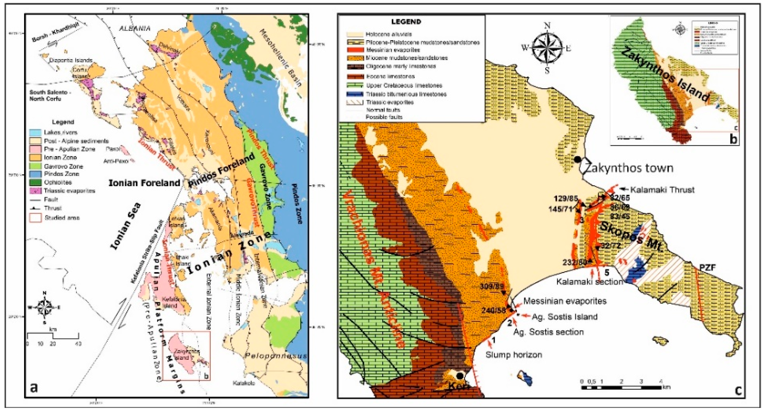
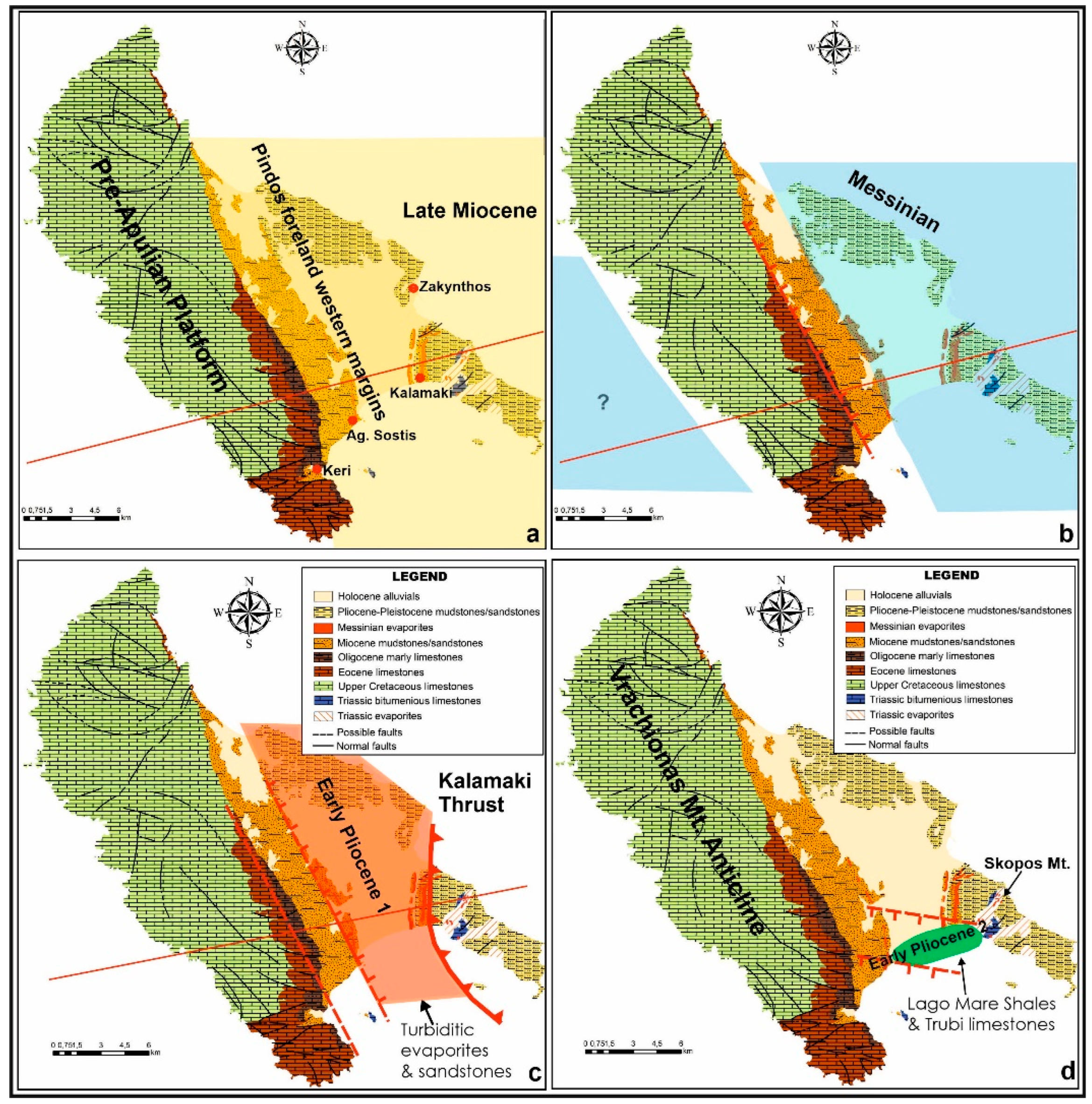
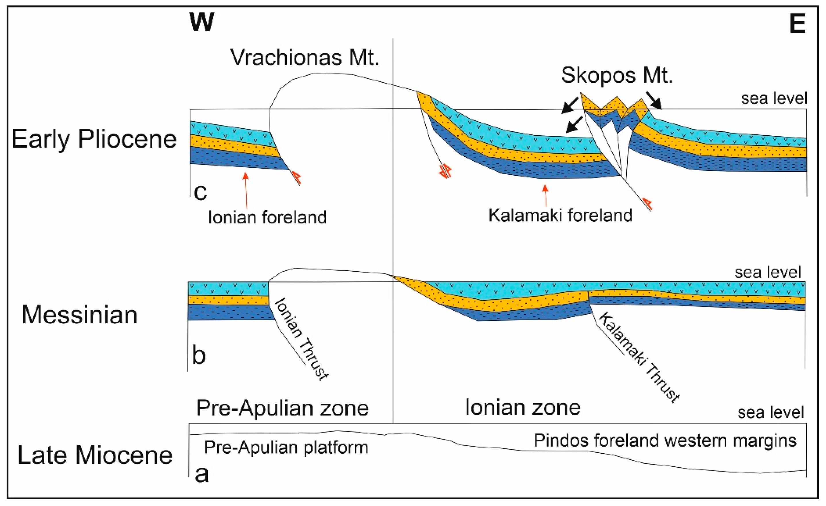
2. Geological Setting

The Hellenides FTB includes both platforms (Pre-Apulian and Gavrovo zones) and deep basins (Ionian and Pindos zones) that exhibit a NNW–SSE direction [18,19]. Zakynthos Island is located in the Pre-Apulian and Ionian zones and was influenced by the major orogenic processes that are related to the Hellenides FTB. The principal tectonic features are the Ionian and the Kalamaki Thrusts (Figure 1). The Pre-Apulian zone lies to the east of the Apulian platform and to the west of the Ionian zone and corresponds to an edge-slope facies belt that is largely covered by the Ionian Thrust [20,21]. The Pre-Apulian zone was renamed to Apulian Platform Margins (APM) [11]. The west directed Hellenides FTB as indicated from deep seismic profiles that acquired north [22] and south of Zakynthos Island [2,10] that influenced the sedimentation from Triassic to Pliocene. Triassic evaporites served as major decollement zones and separated the overlying sediments from the basement rocks [23]. Listric faults that are steeper than the major thrusts occur internally in the uplifted wedge [23]. Further, diapiric intrusions are related either to thrust (during Pliocene) or to back-thrust and strike-slip (during Pleistocene) faults [10]. These intrusions influenced the basin geometry, bathymetry, and the processes that controlled the sedimentation of the basin [10]. The uplift that resulted from these intrusions led to the uplift of the Skopos Mountain. Pleistocene post-depositional deformation took place when the Kalamaki thrust evolved into a back-thrust, eroding the pre-existing deposits [10]. The diapiric intrusions modified the sea-floor topography causing steeper slopes and, in conjunction with the syn-sedimentary strike-slip faults, controlled the depositional processes for the lower Pleistocene deposits.

3. Previous Works and Their Results

Two sections along the south coast of Zakynthos were selected (Figure 1) for re-assessment of the depositional conditions of the Messinian Evaporites, Ag. Sostis to the west and Kalamaki to the east. In both sections at the base, there are upper Miocene clastic sediments (Figure 2), deposited in a shelf environment, evaporites in the middle part and in the upper part white carbonates (Trubi formation) interbedded with marls of the early Pliocene age (Zanclean). The subject of this work is to check and to present details in order for re-assessment, if it is necessary, the depositional conditions of the middle part with evaporites. There are many theories and many published results where these evaporites are a debate between teams of researchers. The major question or difference between these research teams is if the total outcrops with evaporites correspond to in situ Messinian evaporites or a major part of them resedimented as mass flow deposits (gypsum turbidites) in a marine environment after erosion of pre-existing Messinian evaporites during the early Pliocene time.
The problem or the different approach between the two research groups has an impact on the basin evolution and the time of the tectonic activity. Accepting the theory of the Messinian age in total, then the inundation of the basin could relate with the general inundation of the Mediterranean during the early Pliocene. In this case, these Messinian in origin evaporites were redeposited later during the early Pliocene, but before the Mediterranean inundation, as the inundation was related with the sedimentation of Trubi formation with an early Pliocene age. Probably in the second case, the total thickness must be greater from the previous in situ Messinian evaporites, and additionally the fault activity was started earlier than the until now knowledge.

3.1. Publications That Accept the Theory of Resedimented Turbiditic Deposits That Took Place during Early Pliocene

Kontopoulos et al. [17] mostly worked on the Ag. Sostis section with a minor mention on the Kalamaki section. They interpreted the Ag. Sostis section with Messinian evaporites as gypsum turbidites (the section along the coast) (Figure 3b–d) intercalated in a terrigenous turbiditic succession (the sandstones in Ag. Sostis Island) (Figure 4a). These turbidites mostly were transported by dense briny underflows and in minor by erosion in shallow water during sea-level fall. The section of Ag. Sostis harbor was interpreted as shelf deposits due to the presence of hummocky cross-stratification (Figure 4b,c). They mentioned that Kalamaki section (Figure 5b) as consisting at the lower part of 55 m marls with minor calcarinites and gypsiferous partings, probably belonging to the pre-evaporitic sequence of the late Miocene age. The middle part with 113 m thick comprises six cycles, 9–14 m thick each with evaporites at the base and marls on the top. These deposits appear to be shallow water deposits with nodular and banded gypsum but no clear turbiditic deposits. In the upper three cycles, there are nodular gypsum and gypsum conglomerates interbedded with laminated and crystalline gypsum. The upper part rests unconformably, with an erosional contact, over the middle part and corresponds to the Pliocene Trubi limestones (2 m thick) and overlying calcarenites (10 m thick). Moreover, authors agree with the interpretation of Braune and Heimann [26] that the gypsum in the eastern part of the Island is of shallow water origin and is not resedimented. Shallow water Pliocene sediments, suggesting sea level fall during the Messinian, unconformably overlie it.
Zelilidis et al. [27] focused mostly on the Pliocene deposits mentioning that Trubi limestones, at the Ag. Sostis harbor (Figure 4b,c), representing the inundation of the Mediterranean during the Zanclean with the sedimentation in a shelf environment.
Mpotziolis et al. [24] gave the age of sediments in the Ag. Sostis and Kalamaki sections of previous [17,18,19,20,21,22,23,24,25,26,27] and later [28] works. They found that beneath Ag. Sostis evaporites there are also early Pliocene deposits and a characteristic slumped Pliocene horizon with resedimented fossils from the Late Oligocene, Tortonian, and Messinian age (their synthetic stratigraphic column). The age of turbiditic succession is also early Pliocene in age with many reworked fossils of the late Oligocene age. The Kalamaki section showed that the shales on the top of each cycle with evaporites, in the middle part of the Kalamaki section, were deposited during the Early Pliocene with many reworked fossils of the late Oligocene (see the position of the samples in Figure 5a).
Maravelis et al. [25] in Figure 5 present the middle part of the Kalamaki section as early Pliocene in age (Zanclean) based on [24] work. Moreover, they gave a stratigraphy from the western part of the Island, including the Ag. Sostis section where they present a characteristic presence of a slump horizon internally to the lower Pliocene deposits.
Zelilidis et al. [10] questioned the position of the Ionian Thrust in Zakynthos Island (Kalamaki area), and based on sedimentological and structural analyses, reassigned the N–S directed thrust fault in the Kalamaki area (formerly assigned to the Ionian Thrust) as the Kalamaki fault (Figure 1). Zelilidis et al. [10] suggested that this fault commenced during the Pliocene as a thrust fault (in agreement with [30]) and gradually evolved into a back-thrust fault during the Pleistocene. Zelilidis et al. [10] placed the Ionian thrust further westwards at the contact between the clastic deposits and the Vrachionas mountain (Pre-Apulian limestones). This conclusion modifies the boundary between Ionian and Pre-Apulian zones (see [10]), and the two studied locations belong to the same geotectonic zone (Ionian Zone).

3.2. Publications That Accept the Theory of an Evaporitic Sequence That Accumulated during the Messinian Time

Kontakiotis et al. [29] focused on the uppermost part of the Kalamaki section (Trubi Formation, Figure 5a), using the same samples from the work of [28], published first online in 2015. They propose a lowery Pliocene (Zanclean age) for these sediments, after the MSC (after 5.33 Ma), during the inundation of the Mediterranean.
Karakitsios et al. [28] used detailed micropaleontological, magnetostratigraphic, and geochemical data on 176 samples and divided the Kalamaki section into three parts (Figure 5a). One hundred and ten (110) samples were tested from the lower part; no samples were analyzed from the middle part, and sixty-three samples were taken from the upper part. The middle part corresponds to the evaporites, and strontium isotope analyses on two samples were conducted indicating a Messinian age (KCB 3 and KCB6 in [29]). The stratigraphic evolution that was proposed by Karakitsios et al. [30] involves a pre-evaporitic succession (two intervals) that corresponds to the lower part and formed between 6.45 and 5.97 Ma (late Miocene). The middle part (two intervals) was formed between 5.971 and 5.55 Ma, during the MSC (latest Miocene–Messinian). The upper part (two intervals) formed the lower interval during 5.6–5.33 Ma (Lago Mare formation) and the upper interval since 5.33 Ma (Trubi formation). This part corresponds to the Mediterranean inundation (latest Miocene to early Pliocene-Zanclean) (Figure 5a). Despite the lack of paleontological data, the evaporites were assigned to the Messinian evaporites. Karakitsios et al. [28] proposed the same subdivision for the Ag. Sostis section. The lower part corresponds to the pre-evaporitic succession, and the middle part (especially the lower interval) belongs to Messinian stage (5.60–5.55 Ma). This part includes redeposited Messinian evaporites that accumulated through gravity flows. These evaporites slide from the west to east (lower interval). The upper part contains sandstone and marl intercalations and is outcropped in Ag. Sostis Island. This part reflects the inundation of the Mediterranean and is represented by the Trubi formation (1.5 m thick, Ag. Sostis harbor).
Despite the consensus that the evaporites in Ag. Sostis are turbiditic in origin [24,26,28], the tectonic contact (normal fault) between these deposits and the pre-evaporitic mudstones has yet to be explained.

3.3. Additional Contribution to the Debate

Duermeijer et al. [31] from paleomagnetic measurements in Zakynthos showed that, between 0.77 Ma and recent times, Zakynthos underwent a 21.6° ± 7.4° clockwise shift, whereas there is no significant rotation between 8.11 and 0.77 Ma. In contrast, only in one site, on Kalamaki beach, sampling from evaporites, the results showed a rotation 11° anticlockwise, indicating an angle about 32° between the rest deposits and these of evaporites. Although authors suggest omitting this result, from the Kalamaki section, they cannot give an alternative explanation or suggestion of what accounted for this difference. Moreover, authors [31] according to their paleontological analysis suggest a Messinian age for these deposits (5.95–5.21 Ma) without mention on what they based their results on or from which part of the section were the selected/analyzed samples.
The evaporites in the middle part of the Ag. Sostis and Kalamaki sections are of Messinian origin (5.971–5.60 Ma). The lower part of the Ag. Sostis and Kalamaki sections corresponds to the pre-evaporitic succession and was deposited before the MSC (late Miocene, before 5.971 Ma).
The upper part is represented by the post-Messinian evaporitic succession that commences with the Lago Mare Formation (5.36 Ma) and is followed by the lower Pliocene (Zanclean, 5.33–5.08 Ma) Trubi limestones that are interbedded with marls.

The Disagreements

One research group accepts that in the middle part of the Ag. Sostis and Kalamaki sections is of the early Pliocene age (based on a paleontological data set from the evaporites and especially from the mudstone beds, internally to the evaporites, that document an early Pliocene age (Zanclean)). The second research group introduces sedimentation during the Messinian, based mostly on sedimentological data.

4. New Additional Data

4.1. With Re-Interpretation of the Previous Published Papers

Slump horizons and sediments with Bouma subdivisions (turbidites) that were documented in the Ag. Sostis area and are of an early Pliocene age occur under the middle evaporitic part (west of the Ag. Sostis section and towards the Keri village, Figure 6) also introducing an early Pliocene age for the middle part of the Ag. Sostis evaporitic sequence [24]. The presence of Bouma sub-divisions introduce turbiditic currents that were developed in deep environments within an unstable basin floor. Additionally, the fact of the slump’s development introduces that, from the uplifted western part of the Vrachionas mountain (Figure 1c), the pre-existing Miocene deposits slumped eastwards, within the Kalamaki foreland basin, during the early Pliocene, explaining the reason of many re-deposited fossils in the upper Miocene age together with the early Pliocene in situ fossils.
The above two factors introduce that, due to strong tectonic activity, the basin floor was tilted, uplift of the Vrachionas wedge-top, and, due to the instability and the presence of unconsolidated deposits, these deposits slumped eastwards to the Kalamaki foreland basin.
Additionally, the evaporites in the middle part of the Kalamaki section display a large discrepancy in rotation (over 30°) compared to the rest of the deposits [31] probably introducing different depositional conditions. As the [31] showed that there is not any rotation between 8.11 and 0.77 Ma, then the same age deposits must present the same rotation that took place after 0.77 Ma.
Therefore, the middle part with evaporites in the Kalamaki section, if they were deposited during the Messinian time, must present the same rotation with the same age Messinian evaporites. The fact that this part presents a discrepancy in rotation with more than 30o could be explained only if these evaporitic deposits were redeposited from other locations, such as the wedge top of the Kalamaki thrust fault, showing in this case the early Pliocene activity of the Kalamaki thrust fault.

4.2. Adding New Thoughts with New Data

In the Ag. Sostis area (western part of the studied area), the Messinian evaporites exist and outcrop on the top of the pre-evaporitic succession, just west of the turbiditic evaporites (Figure 3a), showing the exact primary location of Messinian evaporites.
In the eastern part of the studied area, close and parallel to the Kalamaki thrust fault, there are four additional facts that were analyzed:
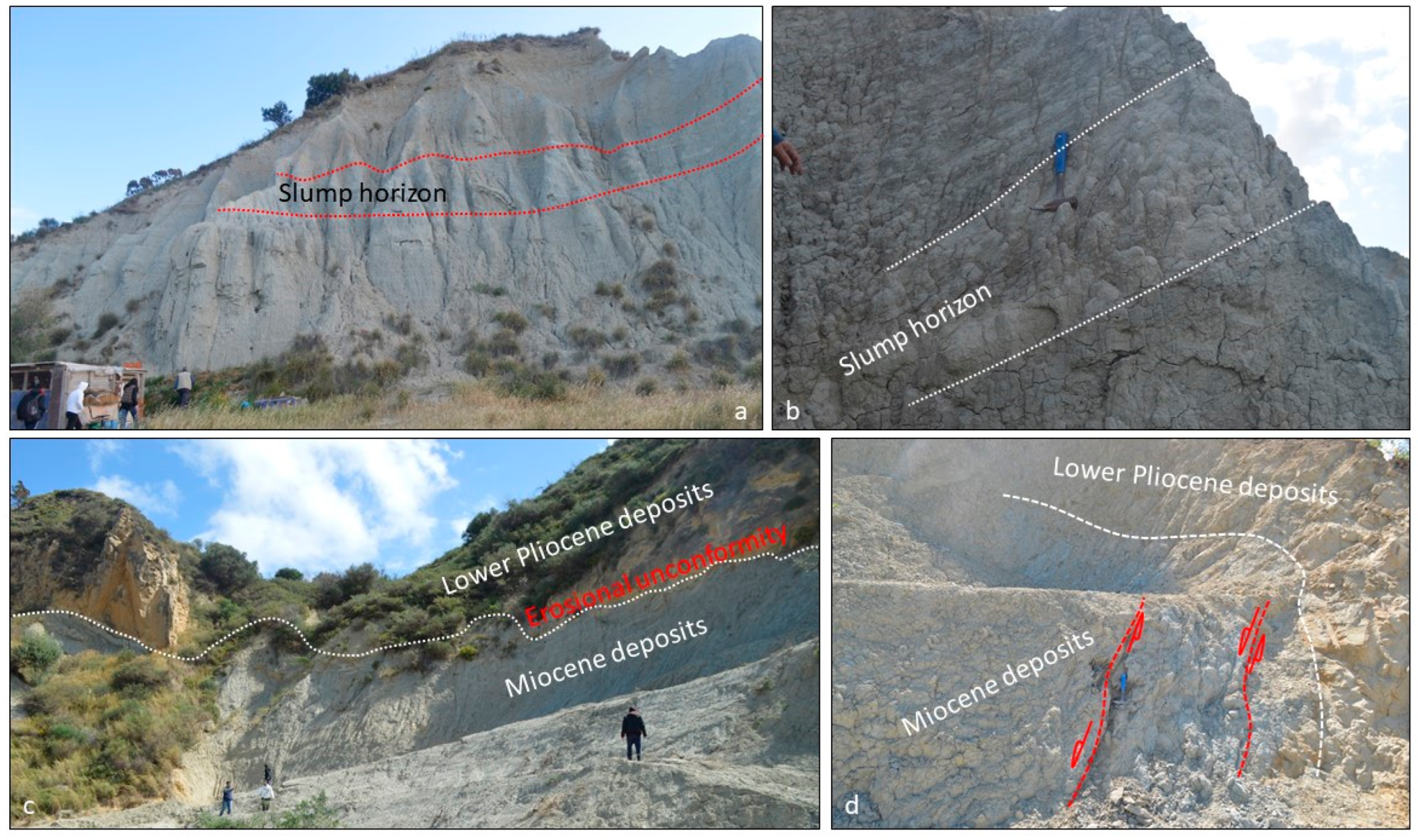
  • Within the lower Pliocene shelf deposits, in the Zakynthos town, a slump horizon was recognized (Figure 7a,b), just west of the Kalamaki back-thrust fault, showing the activity of the thrust during lower Pliocene sedimentation and the so on produced instability of the basin floor. It is obvious that during the lower Pliocene sedimentation, pre-existing deposits were slumped within the Kalamaki foreland from the wedge top of the Kalamaki thrust fault.
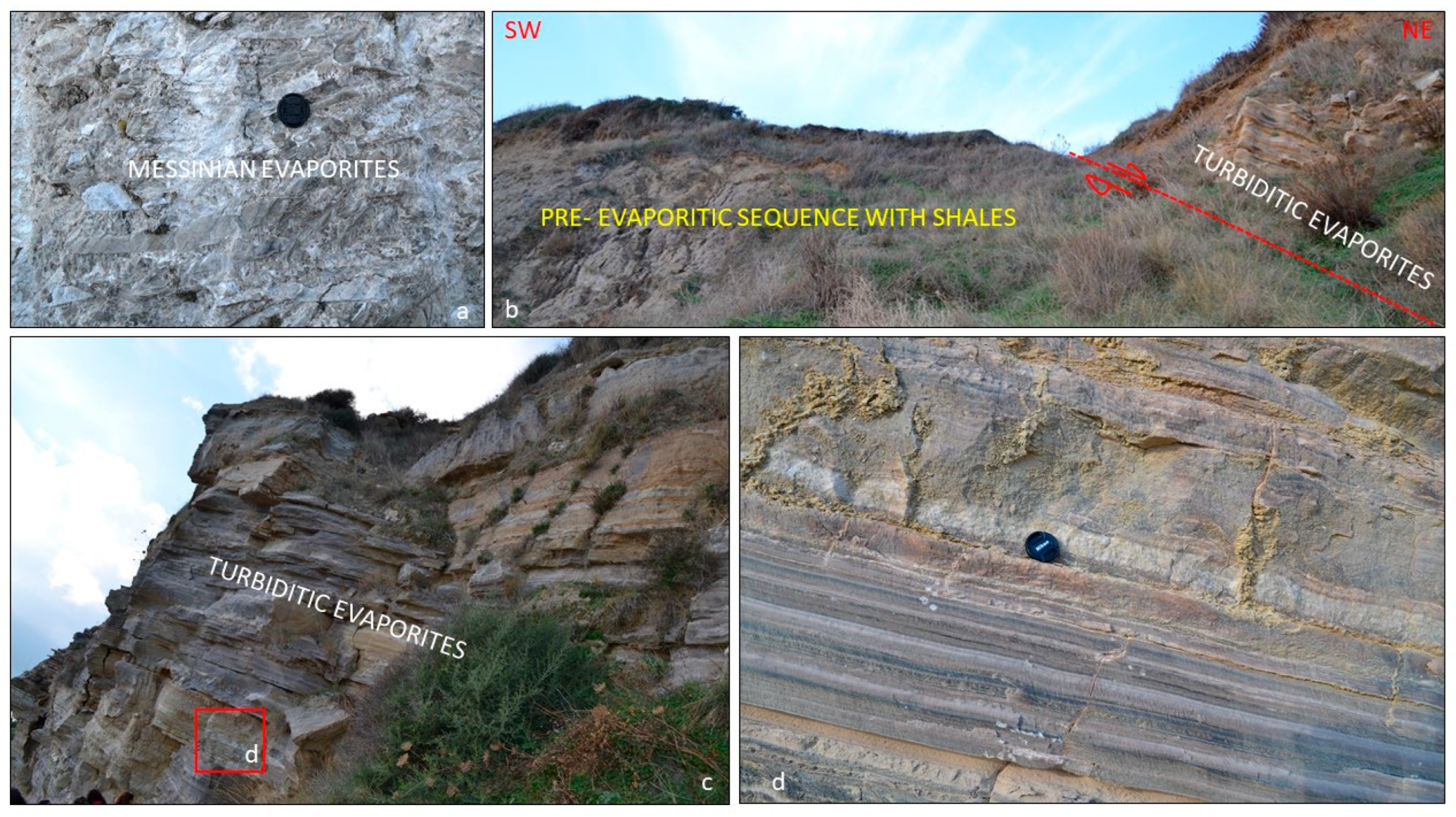
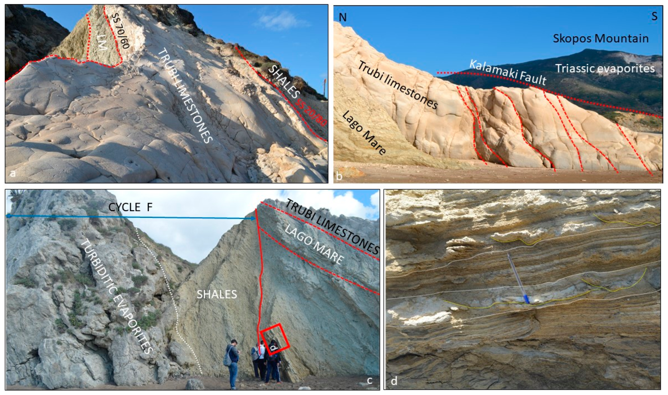
  • In the Panagoula section, the contact between the Miocene and Pliocene is characterized by the absence of Messinian evaporites, and this conduct is an unconformity (Figure 7c). The facts of the Messinian evaporites’ absence and the unconformity boundary, although it is in places with a fault-controlled contact (Figure 7d), could suggest either the erosion of the Messinian pre-existing evaporites and/or that these Messinian evaporites never deposited. The unconformity between Pliocene and Miocene deposits could indicate a shifting of the basin floor, before the sedimentation of the lower Pliocene, probably due to Kalamaki thrust activity. Due to the thrust fault activity, additional faults were created influencing the depositional conditions.
c.
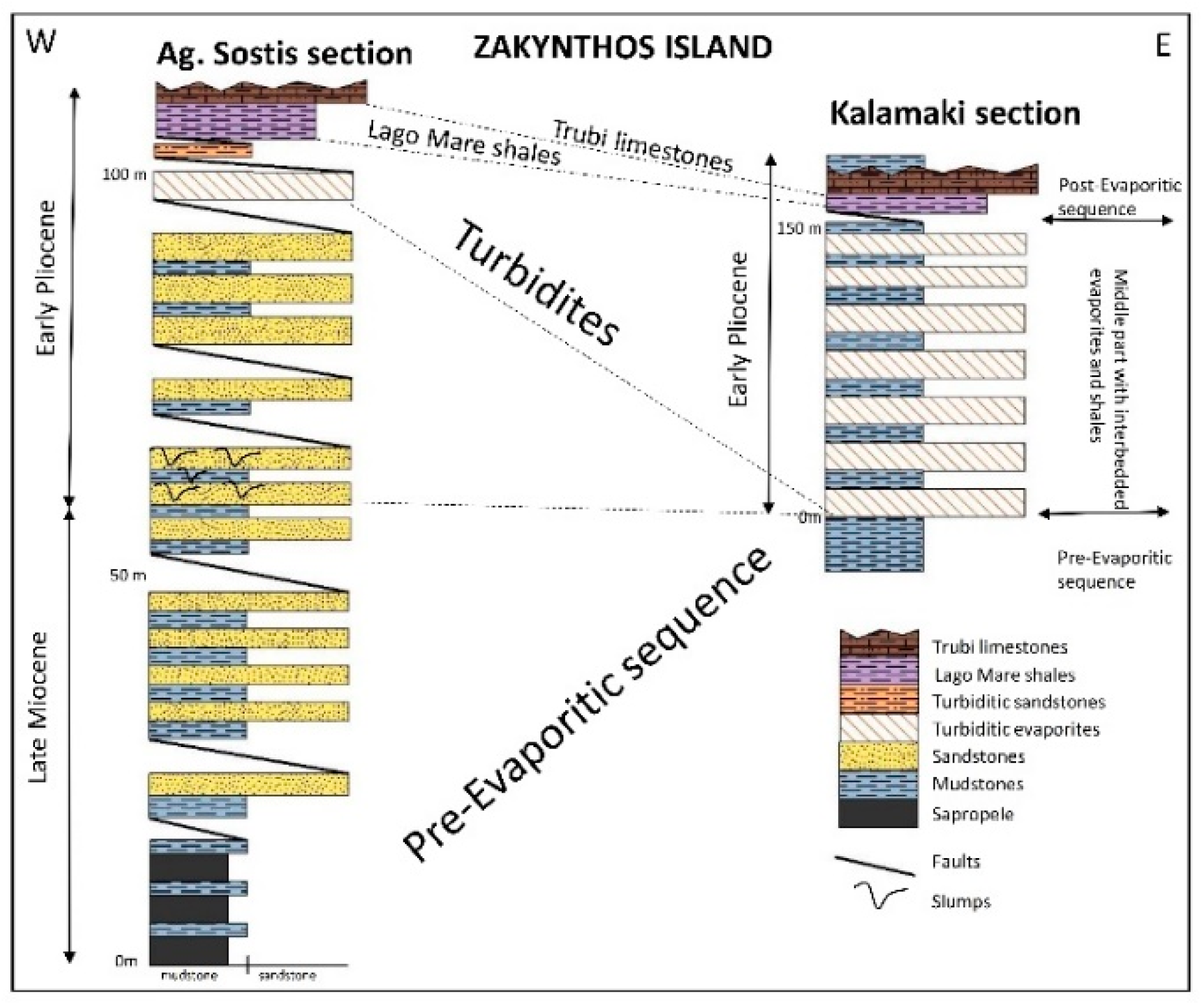
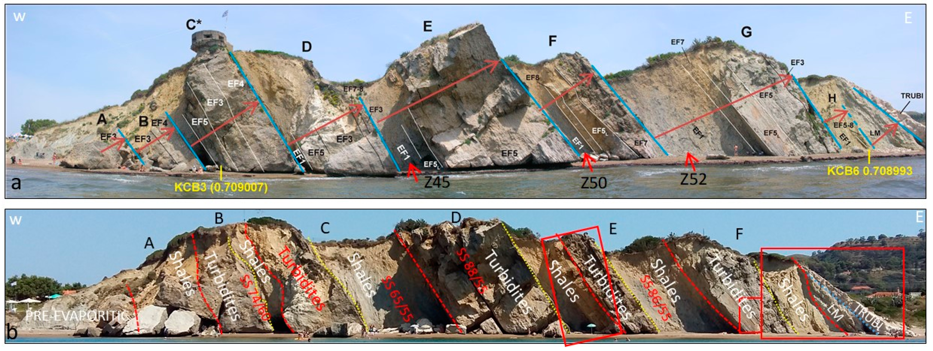
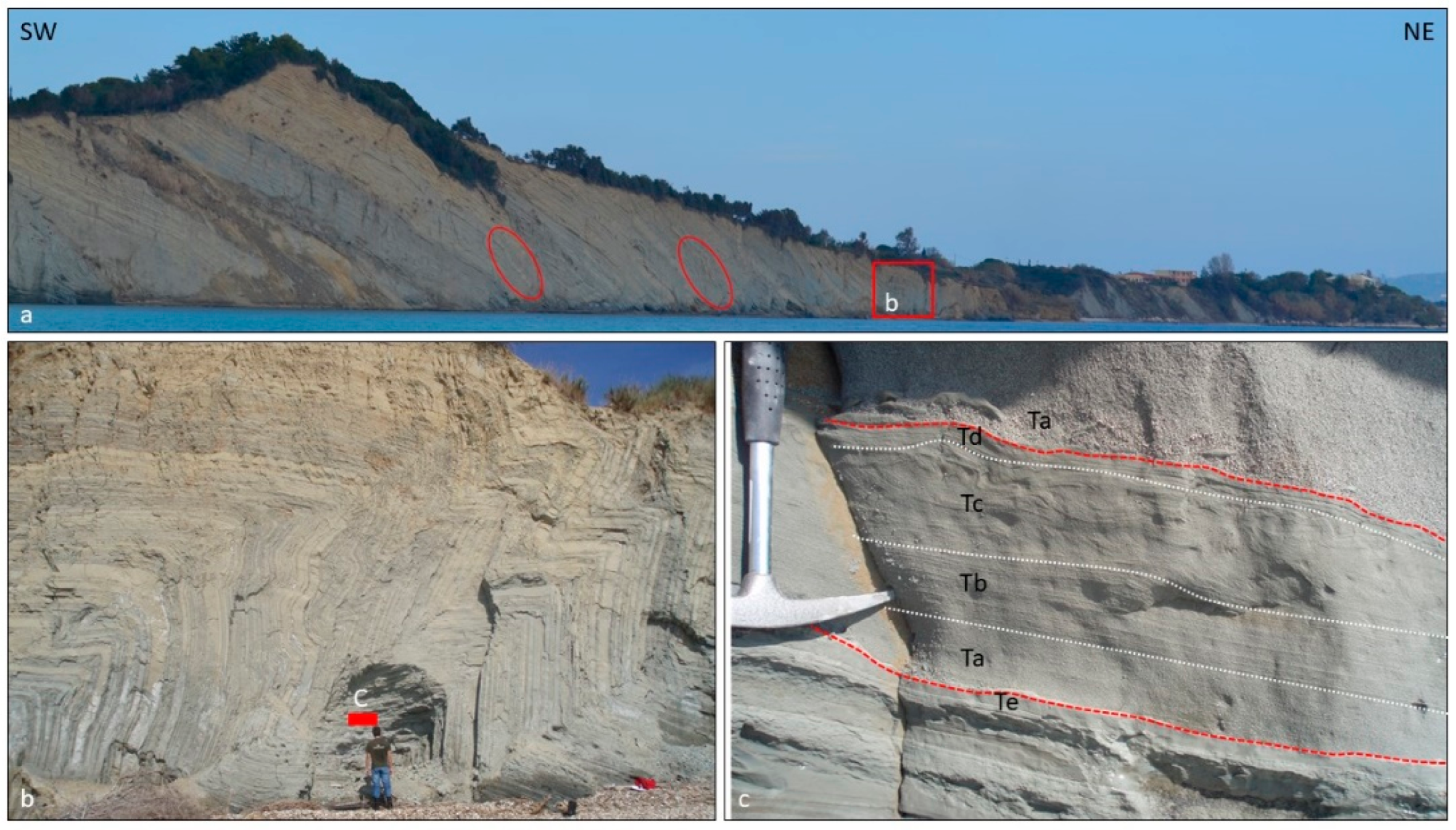
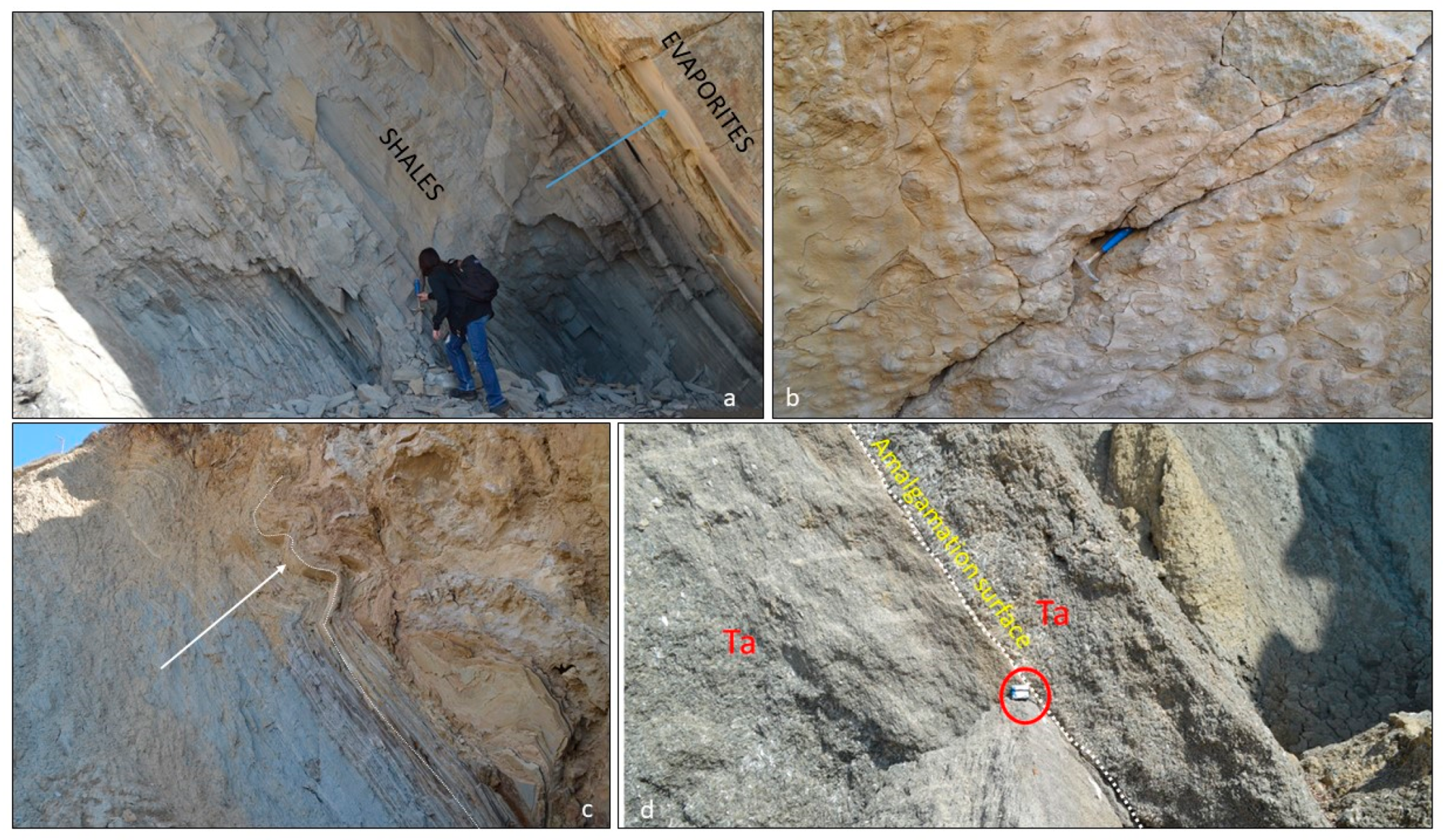
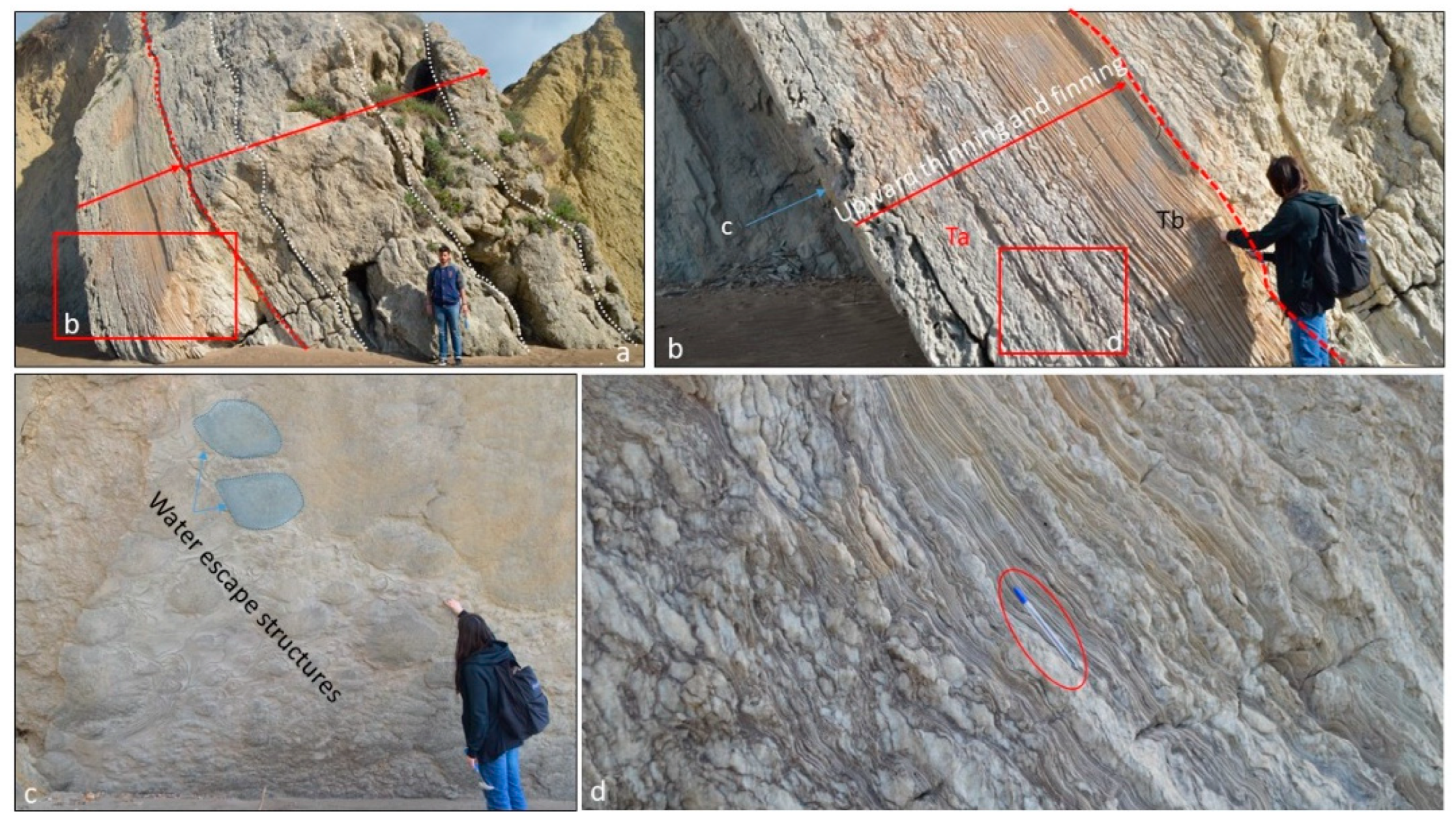
The Kalamaki section, specifically the middle part, is organized into six cycles that contain evaporites at the base and mudstone at the top (Figure 5b). The detailed measurements of bedding planes showed that bed directions indicate three blocks that display different dip directions but the same angle of bedding (74/60, 65/55, 88/55) (Figure 5b). In the same middle part of the Kalamaki section, a deformation structure (slump) was recognized at the top of the thin-bedded mudstone (Figure 8a). The folding is tight at the one edge but laterally diminishes (Figure 8c). Sedimentary structures similar to load casts occur at the lower bed of evaporites (Figure 8b). Evaporites are composed of cycles with a normally graded, fining upward trend (Figure 8d and Figure 9a,b,d). Amalgamation surfaces exist in the Ta Bouma subdivisions (Figure 9a). Water escape structures, associated with high sedimentation rates, occur in this middle part of the evaporites (Figure 9c).
Explaining the new findings in the middle part of the Kalamaki section, it seems that there are at least three different depositional packages, due to internal unconformities, as this suggested different bedding planes’ directions. It seems that sedimentation took place during the thrust fault activity, and as the Kalamaki foreland basin was subsided, there was a shifting of the preexisting beds.
d.
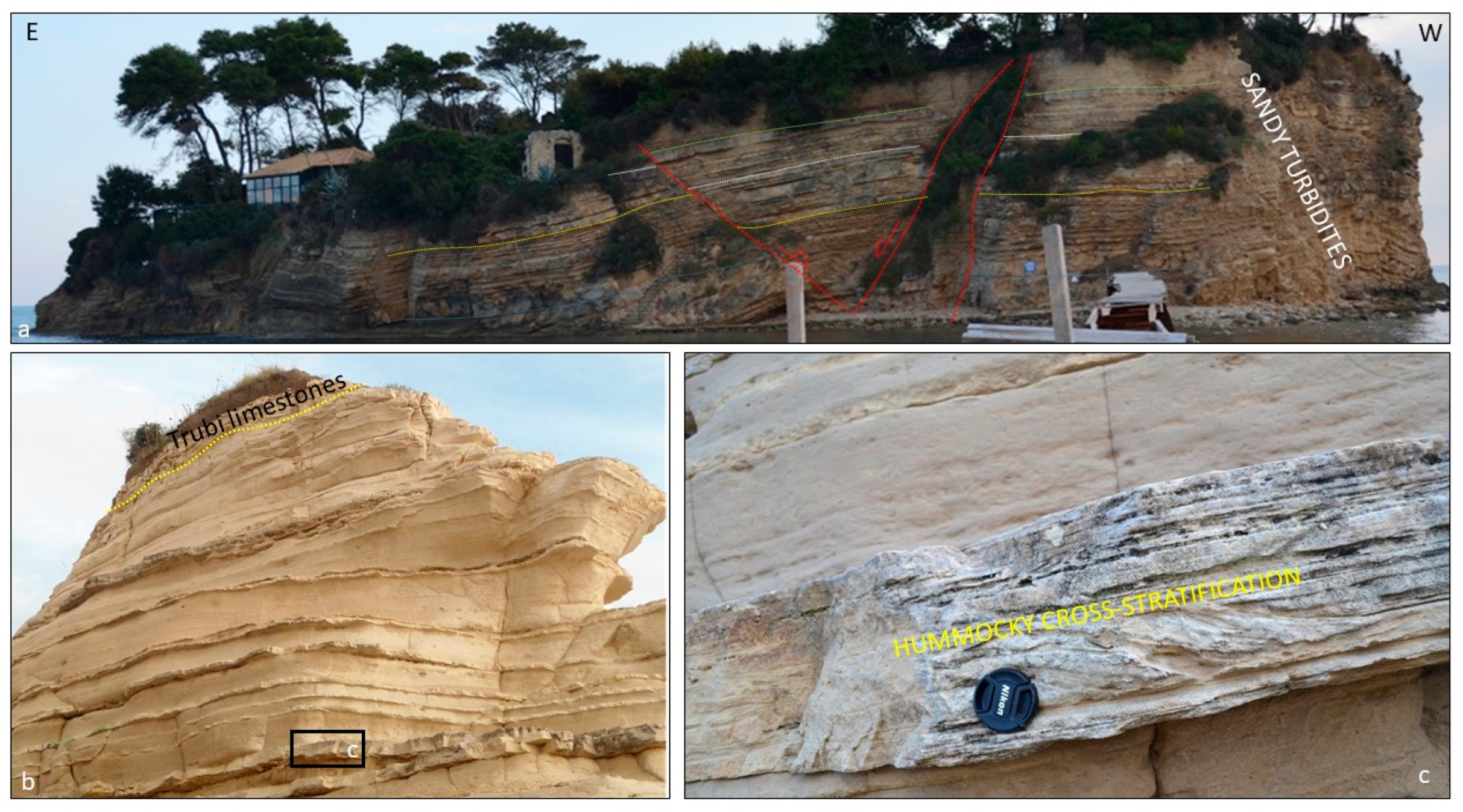
In this Kalamaki section and in the eastern side, Lago Mare and Trubi limestones rest unconformably over the middle evaporitic part, but in some places this contact seems fault-controlled (Figure 10c). This type of contact indicates that tectonic activity controlled the accumulation of these deposits. Mudstone beds that occur at the top of the Trubi limestones rest unconformably over the Trubi limestones (Figure 10a). The mudstone beds underneath the Lago Mare formation contain several slump horizons (Figure 10d), suggesting slope instability during the sedimentation. Trubi formation is cross-cut by normal faults that are directed parallel to the coast (Figure 10b). These faults are probably responsible for the outcrop of the Kalamaki section, which rests on the footwall of these normal faults.
The fault-controlled contact and unconformity between the middle and upper parts (turbiditic evaporites with Lago Mare shales and Trubi limestones), in the Kalamaki section, indicate that sedimentation during the early Pliocene took place in a restricted area close to the thrust fault.
The presence of the Bouma sequence both in the Ag. Sostis section and in the Kalamaki section supports the idea of a foreland basin, this of the Kalamaki foreland where submarine fans were accumulated during the early Pliocene.

5. Discussion—Conclusions

The new presented evidence can led to a new approach for the paleogeographic evolution of Zakynthos Island during late Miocene–Messinian to early Pliocene time and the Messinian evaporites’ development:
The Ionian thrust (in its revised position) and the Kalamaki Thrust (old position of the Ionian Thrust) commenced just prior the Mediterranean inundation (during or before the early Pliocene, Zanclean). The uplifted areas (wedge top) of the two thrust faults exposed the pre-existing upper Miocene shelf deposits and especially the Messinian evaporites that were eroded. This process triggered gravity flows and slumping, leading to the deposition of turbiditic gypsum or slumped blocks that are composed of Messinian evaporites (olisthostroms).
The pre-evaporitic succession (upper Miocene shelf deposits) belongs to the western end of the Pindos foreland basin and has gentle slopes (Figure 11 and Figure 12) that were accumulated before the Kalamaki thrust fault activity.
The Vrachionas anticline, representing the Pre-Apulian zone [28] or the Apulian Platform Margins [11], formed because of the Ionian Thrust activity and represents the wedge top of the Ionian thrust that took place/was activated during the middle to upper Miocene. The new Ionian Foreland is situated to the west of Zakynthos Island (in the Ionian Sea, Figure 11 and Figure 12). During the early Pliocene, this wedge top (Vrachionas anticline) was sourced, with slumping processes, eastwards towards the Kalamaki foreland basin.
Turbiditic evaporites (of Messinian age evaporites in origin) in Ag. Sostis were sourced from the uplifted western area (Vrachionas anticline—wedge top of the new Ionian thrust). The uplift triggered slumping in the lower Pliocene mudstone beds, and subsequently the deposition of the evaporitic turbidites indicate an early Pliocene age.
Slumps that consist of Messinian evaporites were transported and redeposited in the Kalamaki Foreland Basin from the uplifted Skopos Mountain. In the new position, these evaporites present a 32° deficiency in rotation, compared to the in situ clastic deposits (the pre-evaporitic upper Miocene or post-evaporitic lower Pliocene deposits, Figure 11 and Figure 12).
The new Kalamaki Foreland Basin was a narrow and restricted basin and was formed during the Messinian time and was still active during the early Pliocene (Figure 11b,c and Figure 12b,c).
The evaporites display their greater in total thickness in the Kalamaki foreland basin, and especially close to the thrust front, because of the presence of both in situ Messinian evaporites that act as a blanket in the whole basin and lower Pliocene resedimented turbiditic evaporites sourced from the uplifted areas of Skopos mountain (Figure 12b,c).
The Lago Mare shales and Trubi limestones accumulated south of the Kalamaki and Ag. Sostis sections (now are situated offshore, Figure 11d) in a fault-controlled basin. The northern part was filled up with sediments from the eroded uplifted Kalamaki (Skopos Mountain) and Ionian (Vrachionas Mountain) thrust faults.
It is critical to examine thoroughly such outcrops in order to determine the thickness, origin, and aerial distribution of the Messinian evaporites or their re-sedimentation during the early Pliocene. Further, it is important to understand the driving mechanisms and timing of their erosion and re-deposition since they add on to the pre-existing thickness of evaporites. It is very important to understand the timing of fault activity, in regions adjacent to the Messinian evaporites, in order to understand their behavior.
As the Ionian Thrust is critical in hydrocarbon exploration in the Ionian and Adriatic Seas, because many exploration targets are active, the oil companies would like to know if there is and how it is the thickness of the in situ Messinian evaporites internally to the Ionian foreland.
Unravelling the depositional conditions of the Messinian in origin evaporites, in Zakynthos Island, the implication could be established for the sealing capacity in the Mediterranean Sea, as there are many areas with limited detailed measurements of the sedimentological and stratigraphic analysis of the Messinian in origin evaporites that accumulated into the restricted and confined basin with quite different total thicknesses.

Author Contributions

Conceptualization, A.Z., N.B., A.G.M.; data collection, A.Z., K.A., E.G., S.P., D.A.; methodology, A.Z., N.B., A.G.M.; software, N.B.; writing—original draft preparation, A.Z., N.B., A.G.M.; supervision; A.Z.; writing—review and editing; A.Z., N.B., A.G.M. All authors have read and agreed to the published version of the manuscript.

Funding

This research received no external funding.

Institutional Review Board Statement

Not applicable.

Informed Consent Statement

Not applicable.

Data Availability Statement

Not applicable.

Acknowledgments

The authors would like to thank reviewers for their improvements on the manuscript.

Conflicts of Interest

The authors declare no conflict of interest.

References

  1. Zelilidis, A.; Maravelis, A.G. Introduction to the thematic issue: Adriatic and Ionian Seas: Proven petroleum systems and future prospects. J. Pet. Geol. 2015, 38, 247–253. [Google Scholar] [CrossRef]
  2. Zelilidis, A.; Maravelis, A.G.; Tserolas, P.; Konstantopoulos, P.A. An overview of the petroleum systems in the Ionian zone, onshore NW Greece and Albania. J. Pet. Geol. 2015, 38, 331–348. [Google Scholar] [CrossRef]
  3. De Graciansky, P.; De Dardeau, G.; Lemoine, M.; Tricart, P. The inverted margin of the French Alps. In Inversion Tectonics; Cooper, M.A., Williams, G.D., Eds.; Geological Society of London Special Publications: London, UK, 1989; Volume 44, pp. 105–122. [Google Scholar]
  4. Doutsos, T.; Koukouvelas, I.; Xypolias, P. A new orogenic model for the External Hellenides. In Tectonic Evolution of the Eastern Mediterranean Regions; Robertson, A.H.F., Mountrakis, D., Brun, J.-P., Eds.; Geological Society of London Special Publications: London, UK, 2006; Volume 260, pp. 507–520. [Google Scholar]
  5. Kokkalas, S.; Kamberis, E.; Xypolias, P.; Sotiropoulos, S.; Koukouvelas, I. Coexistence of thin- and thick-skinned tectonics in Zakynthos area (western Greece): Insights from seismic sections and regional seismicity. Tectonophysics 2013, 598, 73–84. [Google Scholar] [CrossRef]
  6. Avramidis, P.; Zelilidis, A. The nature of deep-marine sedimentation and palaeocurrent directions as evidence of Pindos foreland basin fill conditions. Episodes 2001, 24, 252–256. [Google Scholar] [CrossRef] [Green Version]
  7. Underhill, J.R. Late Cenozoic deformation of the Hellenide foreland, Western Greece. Geol. Soc. Am. Bull. 1989, 101, 613–634. [Google Scholar] [CrossRef]
  8. Maravelis, A.; Makrodimitras, G.; Zelilidis, A. Hydrocarbon prospectivity in Western Greece. Oil Gas Eur. J. 2012, 38, 84–89. [Google Scholar]
  9. Maravelis, A.; Makrodimitras, G.; Pasadakis, N.; Zelilidis, A. Stratigraphic evolution and source rock potential of a Lower Oligocene to Lower-Middle Miocene continental slope system, Hellenic fold and thrust belt, Ionian Sea, northwest Greece. Geol. Mag. 2014, 151, 394–413. [Google Scholar] [CrossRef]
  10. Zelilidis, A.; Papatheodorou, G.; Maravelis, A.; Christodoulou, D.; Tserolas, P.; Fakiris, E.; Dimas, X.; Georgiou, N.; Ferentinos, G. Interplay of thrust, back-thrust, strike-slip and salt tectonics in a Fold and Thrust Belt system: An example from Zakynthos Island, Greece. Int. J. Earth Sci. 2016, 105, 2111–2132. [Google Scholar] [CrossRef]
  11. Bourli, N.; Iliopoulos, G.; Zelilidis, A. Reassessing Depositional Conditions of the Pre-Apulian Zone Based on Synsedimentary Deformation Structures during Upper Paleocene to Lower Miocene Carbonate Sedimentation, From Paxoi and Anti-Paxoi islands, Northwestern end of Greece. Minerals 2022, 12, 201. [Google Scholar] [CrossRef]
  12. CIESM (Commission Internationale pour l’Exploration Scientifi que de la mer Méditerranée). The Messinian salinity crisis from mega-deposits to microbiology. In A consensus Report: CIESM Workshop Monographs; Briand, F., Ed.; CIESM Workshop Monographs: Menton, France, 2008; Volume 33, 168p. [Google Scholar]
  13. Iadanza, A.; Sampalmieri, G.; Cipollari, P.; Cosentino, D.; Mola, M. Hydrocarbon-seep Scenarios in the Western Mediterranean Margin during the Messinian Salinity Crisis: Onland Case Studies from the Italian Peninsula. AAPG Eur. Reg. Conf. Exhib. Barc. Sp 2013. Search and Discovery Article 41176. [Google Scholar]
  14. Manzi, V.; Gennari, R.; Hilgen, F.; Krijgsman, W.; Lugli, S.; Roveri, M.; Sierro, F.J. Age refinement of the Messinian salinity crisis onset in the Mediterranean. Terra Nova 2013, 25, 315–322. [Google Scholar] [CrossRef]
  15. Roveri, M.; Bertini, A.; Cosentino, D.; Di Stefano, A.; Gennari, R.; Gliozzi, E.; Grossi, F.; Iaccarino, S.M.; Lugli, S.; Manzi, V.; et al. A high-resolution stratigraphic framework for the latest Messinian events in the Mediterranean area. Stratigraphy 2008, 5, 323–342. [Google Scholar]
  16. Lugli, S.; Gennari, R.; Gvirtzman, Z.; Manzi, V.; Roveri, M.; Schreiber, C. Evidence of clastic evaporites in the canyons of the Levant Basin (Israel): Implications for the Messinian salinity crisis. J. Sediment. Res. 2013, 83, 942–954. [Google Scholar] [CrossRef] [Green Version]
  17. Kontopoulos, N.; Zelilidis, A.; Piper, D.J.W.; Mudie, P.J. Messinian evaporites in Zakynthos, Greece. Palaeogeogr. Palaeoclimatol. Palaeoecol. 1997, 129, 361–367. [Google Scholar] [CrossRef]
  18. Robertson, A.H.F.; Clift, P.D.; Degnan, P.J.; Jones, G. Palaeogeographic and palaeotectonic evolution of the eastern Mediterranean Neotethys. Palaeogeogr. Palaeoclimatol. Palaeoecol. 1991, 87, 289–343. [Google Scholar] [CrossRef]
  19. Papanikolaou, D. Timing of tectonic emplacement of the ophiolites and terrane paleogeography in the Hellenides. Lithos 2009, 108, 262–280. [Google Scholar] [CrossRef]
  20. BP Co. Ltd. The Geological Results of Petroleum Exploration in Western Greece. Inst. Geol. Subsurf. Res. 1971, 10, 1971. [Google Scholar]
  21. Jenkins, D.A.L. Structural development of western Greece. AAPG Bull. 1972, 56, 128–149. [Google Scholar]
  22. Kamberis, E.; Marnelis, F.; Loucoyannakis, M.; Maltezou, F.; Hirn, A.; Group Streamers. Structure and deformation of the External Hellenides based on seismic data from offshore western Greece. In Oil and Gas in Alpidic Thrust Belts and Basins of Central and Eastern Europe; Wessely, G., Liebl, W., Eds.; EAGE Special Publication: Amsterdam, The Netherlands, 1996; pp. 207–214. [Google Scholar]
  23. Kokinou, E.; Kamberis, E.; Vafidis, A.; Monopolis, D.; Ananiadis, G.; Zelilidis, A. Deep seismic reflection data from offshore western Greece: A new crustal model for the Ionian Sea. J. Pet. Geol. 2005, 28, 185–202. [Google Scholar] [CrossRef]
  24. Mpotziolis, C.; Kostopoulou, S.; Triantaphyllou, M.; Zelilidis, A. Depositional environments and hydrocarbon potential of the Miocene deposits of Zakynthos Island. Bull. Geol. Soc. Greece 2013, XLVII, 2101–2110. [Google Scholar] [CrossRef] [Green Version]
  25. Maravelis, A.; Koukounya, A.; Tserolas, P.; Pasadakis, N.; Zelilidis, A. Geochemistry of Upper Miocene-Lower Pliocene source rocks in the Hellenic fold and thrust belt, Zakynthos Island, Ionian Sea, western Greece. Mar. Pet. Geol. 2015, 66, 217–230. [Google Scholar] [CrossRef]
  26. Braune, K.; Heimann, K.O. Miocene evaporites on the Ionian Islands. Bull. Geol. Soc. Greece 1973, 10, 25–30. [Google Scholar]
  27. Zelilidis, A.; Kontopoulos, N.; Avramidis, P.; Piper, D.J.W. Tectonic and sedimentological evolution of the Pliocene-Quaternary basins of Zakynthos Island, Greece: Case study of the transitions from compressional to extensional tectonics. Basin Res. 1998, 10, 393–408. [Google Scholar] [CrossRef]
  28. Karakitsios, V.; Roveri, M.; Lugli, S.; Manzi, V.; Gennari, R.; Antonarakou, A.; Triantaphyllou, M.; Agiadi, K.; Kontakiotis, G.; Kafousia, N.; et al. A record of the Messinian salinity crisis in the eastern Ionian tectonically active domain (Greece, eastern Mediterranean). Basin Res. 2017, 29, 203–233. [Google Scholar] [CrossRef]
  29. Kontakiotis, G.; Karakitsios, V.; Mortyn, P.G.; Antonarakou, A.; Drinia, H.; Anastasakis, G.; Agiadi, K.; Kafousia, N.; De Rafelis, M. New insights into the early Pliocene hydrographic dynamics and their relationship to the climatic evolution of the Mediterranean Sea. Palaeogeogr. Palaeoclimatol. Palaeoecol. 2016, 459, 348–364. [Google Scholar] [CrossRef]
  30. Underhill, J.R. Triassic evaporites and Plio-Quarternary diapirism in Western Greece. J. Geol. Soc. Lond. 1998, 145, 269–282. [Google Scholar] [CrossRef]
  31. Duermeijer, C.E.; Krijgsman, W.; Langereis, C.G.; Meulenkamp, J.E.; Triantafyllou, M.V.; Zachariasse, W.J. A late Pleistocene clockwise rotation phase of Zakynthos (Greece) and implications for the evolution of the western Aegian arc. Earth Planet. Sci. Lett. 1999, 173, 315–331. [Google Scholar] [CrossRef] [Green Version]
Figure 1. (a) Geological map of western Greece, where the characteristic Ionian thrust and Ionian foreland are marked, respectively. Red box shows Figure 1b of the Zakynthos Island. (b) The geological map of Zakynthos Island. Red box shows the location of the studied area of Figure 1c. (c) Detailed geological map of the studied area where bed direction and angle of inclination are marked. Moreover, studied sections and studied places are marked.
Jmse 11 00271 g001
Figure 2. Synthetic stratigraphic column of the studied deposits, modified from [24,25], showing the two studied sections of Ag. Sostis and Kalamaki. With blue stars in Kalamaki section the places from where the Early Pliocene age was determined [24] were marked.
Jmse 11 00271 g002
Figure 3. (a) Messinian evaporites very close to Ag. Sostis section. (b) Part of Ag. Sostis section with the fault-controlled contact between pre-evaporitic sections with the turbiditic evaporites. (c) The turbiditic evaporites and (d) from close the turbidites mostly with Tb Bouma sub-interval.
Jmse 11 00271 g003
Figure 4. (a) The Island of Ag. Sostis where the turbiditic sandstones were outcropped. See the marked faults due to which there is no continuity from turbiditic evaporites to the post-evaporitic sequence in the harbor where the Trubi limestones (b) were outcropped. (c) Hummocky cross-stratification within the post-evaporitic sequence introducing a shelf environment.
Jmse 11 00271 g004
Figure 5. The Kalamaki section into two interpretations. (a) [29] where we add the position of the three samples from Mpotziolis et al. [24] with which the Early Pliocene age was determined for this part of the Kalamaki section. (b) The new interpretation of the same section with additional data. Bed directions were added and the cycles with evaporites and shales re-organized.
Jmse 11 00271 g005
Figure 6. (a)The section along the beach, between Keri and Ag. Sostis villages, where an Early Pliocene slump horizon (b) was recognized with Bouma sub-divisions (c). For the position, see Figure 1c.
Jmse 11 00271 g006
Figure 7. (a,b) The slump horizon within the lower Pliocene deposits close to the Zakynthos town. (c,d). The contact between upper Miocene and lower Pliocene deposits with either erosional contact or fault-controlled. See the absence of Messinian evaporites. For the position, see Figure 1c.
Jmse 11 00271 g007
Figure 8. (a) Thinly bedded shales between turbiditic evaporites. Arrow shows b, the base of evaporites. (b) Evaporites at their base formed structures like load-casts. (c) On the top of shales, there are strong deformed shales (white arrow) and this deformation gradually finished. (d) Cycles internally to the evaporites; white line marks the contact between cycles, which probably represents an amalgamation surface between Ta Bouma sub-divisions.
Jmse 11 00271 g008
Figure 9. (a) The upper part of turbiditic evaporites between shales. See amalgamation surfaces internally to the evaporites, marked with white dashed lines. Red line shows the contact between two cycles. (b) The lower part of the above evaporitic horizon with characteristic fining and thinning upward trend. Blue arrow shows the base of these evaporites. (c) Water-escaped structures clearly showed at the base of the above evaporitic horizon. (d) Strong deformation within this lower cycle of the evaporitic turbidites.
Jmse 11 00271 g009
Figure 10. (a) View of Trubi limestones with bed direction and the contact with the overlying shales. See the great difference between them in bed directions. (b) Lago Mare and Trubi limestones in contact. See the faults that cross-cut the Trubi limestones. In this figure, it is marked the position of Kalamaki fault and the Skopos Mountain with the Triassic evaporites. (c) See both the-fault controlled and unconformity contact between the upper part of turbiditic evaporites and Lago Mare and Trubi limestones. (d) Strong deformation internally to the beds under the Lago Mare deposits.
Jmse 11 00271 g010
Figure 11. Paleogeographic maps showing in four stages the distribution of the sediments into the existing basins. (a) During Late Miocene, as the western part of the Pindos foreland, (b) during the Messinian, when the whole basin was desiccated, (c) during Early Pliocene, when the uplifted Messinian evaporites slid or eroded and resedimented into the Kalamaki Foreland (stage 1), (d) during Early Pliocene (stage 2), when the basin was restricted southwards, and Lago Mare and Trubi limestones were deposited.
Jmse 11 00271 g011
Figure 12. Evolutionary models showing in three stages (Late Miocene, Messinian, and Early Pliocene) the studied area that influenced from the two major thrust faults. (a) During Late Miocene, Vrachionas Mountain represents the Apulian Platform Margins, passing gradually eastwards to the Ionian Basin. (b) During Messinian, both thrusts were active, producing the Kalamaki and Ionian foreland basins, respectively. (c) During Early Pliocene, Kalamaki thrust acted as back-thrust producing on its wedge top three small-restricted sub-basins (Argasi, Mellas, and Xirakastello [10]). Red line in Figure 11 shows the position of cross-sections.
Jmse 11 00271 g012
Disclaimer/Publisher’s Note: The statements, opinions and data contained in all publications are solely those of the individual author(s) and contributor(s) and not of MDPI and/or the editor(s). MDPI and/or the editor(s) disclaim responsibility for any injury to people or property resulting from any ideas, methods, instructions or products referred to in the content.

