Article

Research on the Assessment Method of Sugarcane Cultivation Suitability in Guangxi Province, China, Based on Multi-Source Data

1
Key Laboratory of Digital Earth Science, Aerospace Information Research Institute, Chinese Academy of Sciences, Beijing 100094, China
2
School of Computer Science and Information Security, Guilin University of Electronic Technology, Guilin 541004, China
3
China-ASEAN Regional Innovation Center for Big Earth Data, Nanning 530022, China
4
Cultivated Land Quality Monitoring and Protection Center, Ministry of Agriculture and Rural Affairs, Beijing 100125, China
5
School of Forestry, Hainan University, Haikou 570228, China
*
Author to whom correspondence should be addressed.
Agriculture 2023, 13(5), 988; https://doi.org/10.3390/agriculture13050988
Submission received: 14 April 2023 / Revised: 27 April 2023 / Accepted: 28 April 2023 / Published: 29 April 2023

Abstract

:
Conducting suitability assessment for sugarcane cultivation is of great significance for optimizing the sugarcane cultivation structure and industrial layout. In this paper, based on the requirements of sugarcane growth and development on climate, terrain, and other environmental conditions, as well as the influence of natural disasters, a total of 11 specific indicators in terms of climate factor, terrain factor, and disaster factor were selected to construct a sugarcane cultivation suitability assessment system based on the analytic hierarchy process (AHP). Then, using Guangxi Province, China, as an example, a suitability assessment for sugarcane cultivation was conducted using multi-source data on climate, terrain, and hazards over the past 30 years. The results showed that among 11 indicators, including annual average temperature, elevation had the largest contribution rate, followed by precipitation during the period of ≥20 °C, slope, and the autumn drought frequency. From the spatial distribution, 37% of the provincial regions were suitable for sugarcane cultivation, mainly distributed in Chongzuo City, Nanning City, Qinzhou City, and Beihai City. In total, 44% of the provincial regions were moderately suitable for sugarcane cultivation, mainly distributed in Hezhou City, Laibin City, and Liuzhou City. Additionally, only 19% of the provincial regions were unsuitable for sugarcane cultivation, mainly distributed in Baise City, Hechi City, and Guilin City, with the terrain factor being the main influencing factor of sugarcane suitability assessment. In order to make reasonable use of land resources and increase sugarcane yield, it is suggested that sugarcane cultivation areas should be adjusted to the central and southern regions such as Chongzuo City, Nanning City, Beihai City, and Qinzhou City, and other industries should be developed in the northern regions which are not suitable for sugarcane cultivation.

1. Introduction

Sucrose is a natural monosaccharide derived from plants such as sugarcane and sugar beet. It is widely used in the food, beverage, pharmaceutical, and cosmetic industries. The production and supply of sucrose is critical to ensuring the domestic supply of food and agricultural products and is an indispensable part of the national economy and food production [1]. Sugarcane, as the main raw material for sugar production, is an important economic crop worldwide. It is also a tropical and subtropical crop [2]. In addition to its use as a raw material for the production of sugar, sugarcane has a wide variety of uses and benefits, including for bioenergy, fiber materials, and medical materials. Therefore, sugarcane plays an important role in human life and economic development [3]. In China, sugarcane is the main sugar crop, accounting for more than 90% of the country’s sugar production [4,5]. Guangxi Province, as the main sugarcane producing region in China, has for many years had a sugarcane acreage and yield exceeding 60% of the national total, ranking first in the country. Therefore, the sugarcane industry in Guangxi Province is not only an important pillar of the region’s economic development but also plays an important role in promoting the development of the national sugarcane industry [6]. Therefore, the scientific assessment of the suitability of sugarcane cultivation in Guangxi Province is of great importance, especially in providing important information and references for resolving the conflicts between people and land and sugarcane cultivation.
In the past, domestic and foreign scholars have mostly used the comprehensive weighted index method to study the suitability of crop cultivation. They established an appropriate assessment system by considering multiple factors such as soil, meteorology, and economics; determined the weight of each factor using methods such as AHP; and finally, obtained the suitability of crop cultivation based on GIS. For example, Hikmet et al. [7], Huang et al. [8], Deng et al. [9], and others have conducted research on the suitability of various crops such as wheat, torreya, and rice. In addition, domestic and foreign scholars have also used this method to study the suitability of sugarcane cultivation. For example, Mubashir et al. [10] assessed the suitability of sugarcane cultivation in the Bijnor region of India based on 10 factors, including rainfall, soil texture, drainage, soil depth, slope, distance to the main road, distance to the nearest sugar factory, erosion hazards, flood risks, and pH. Jim et al. [11] assessed the suitability of sugarcane cultivation in central Bukidnon, Philippines, based on six factors including soil depth, water-holding capacity, slope direction, soil texture, slope, and elevation. Xie et al. [12] assessed the suitability of sugarcane cultivation in the Jiangzhou District, Chongzuo City, Guangxi Province, based on four factors: soil, topography, climate, and economy. In addition to the above methods, some scholars have used different methods to study the suitability of sugarcane cultivation. For example, Tan et al. [13] used 44 years of meteorological station statistics combined with the characteristics of sugarcane cultivation to study the optimization of the meteorological disaster layout for the sugarcane industry in Guangxi Province. Liu et al. [14] compared and analyzed 35 years of measured data from 14 meteorological stations in Hainan with the main climate indicators for sugarcane cultivation and assessed the climate suitability for sugarcane cultivation in Hainan Province. An analysis of previous sugarcane cultivation suitability studies shows that there are more studies using climate and terrain factors to assess the suitability of sugarcane cultivation, including recent references and data from international reports. However, due to the special geographical environment and frequent meteorological disasters in Guangxi Province, it is necessary to include a disaster factor in the assessment of sugarcane cultivation suitability. However, there are few reports in the current research on sugarcane cultivation suitability that combines the disaster factor with climate and terrain.
In this paper, we hypothesize that climate factors, terrain factors, and disaster factors are key factors that affect the suitability of sugarcane cultivation in Guangxi Province, China. Specifically, we expect that temperature, precipitation, terrain elevation difference, slope, aspect, disaster frequency, altitude, and other factors will significantly affect the suitability of sugarcane cultivation, and we further hypothesize that the direction and degree of these effects may vary across different regions of Guangxi Province. Our study aims to verify these hypotheses through the construction of an assessment system and the analysis of the results, and to provide decision-making support for optimizing the sugarcane cultivation structure.

2. Materials and Methods

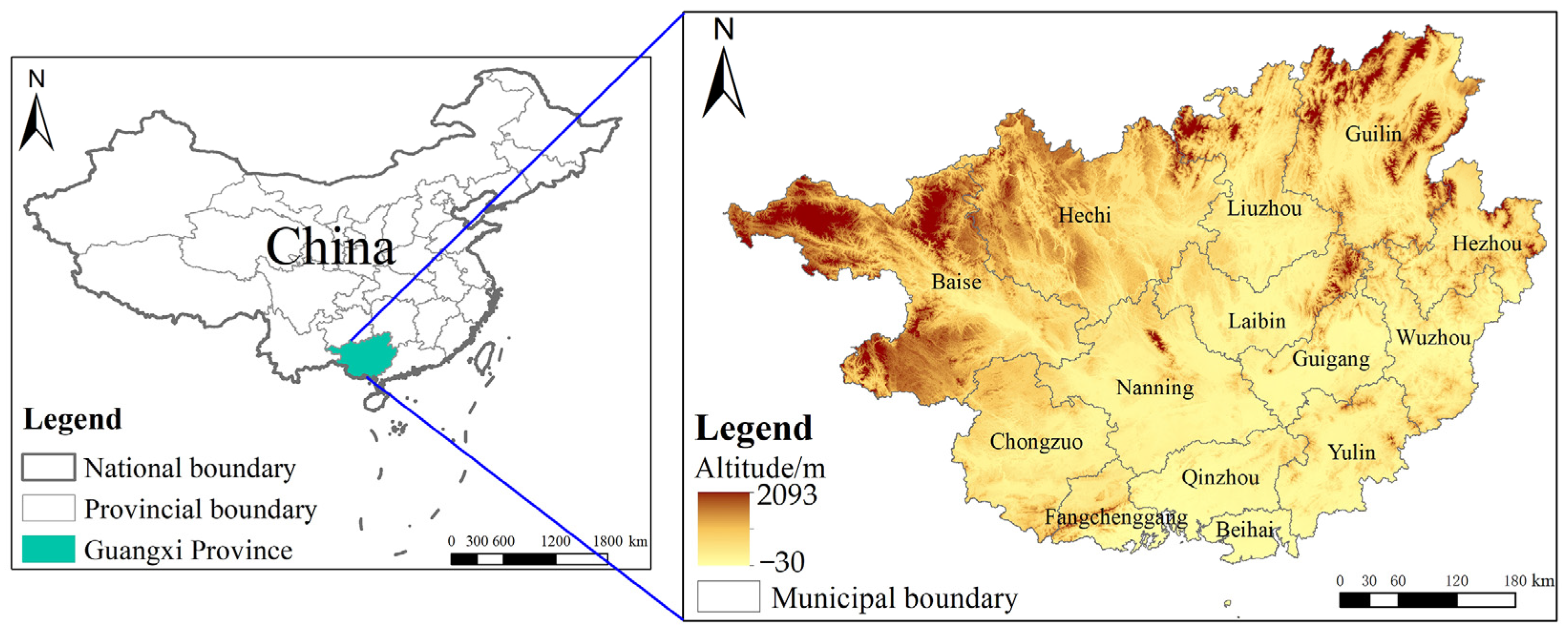
2.1. Research Area Overview

Guangxi Province is located in the southern region of China, between 104°28′~112°04′ E and 20°54′~26°23′ N, bordering Guangdong Province to the east, facing the Beibu Gulf to the south and across the sea from Hainan Island, adjacent to Yunnan Province to the west, connected to Hunan Province to the northeast, and bordering Guizhou Province to the northwest [15]. It is located at a low latitude and a large north–south latitude, with significant climate differences across the region [16]. It belongs to the subtropical and tropical monsoon climate zone of Central and South Asia, with an average annual temperature of 16.5–23.1 °C, an average annual precipitation of 1000–2800 mm, and an average annual sunshine duration of 1169–2219 h [17]. The unique climate provides favorable conditions for the cultivation of various crops such as sugarcane, citrus, bananas, and rice. Sugarcane is the main economic crop in Guangxi Province and the main source of income for farmers [18]. Guangxi Province is mainly composed of different types of landforms, such as mountains, hills, tablelands, and plains. The central and southern parts of Guangxi Province are mainly hilly and flat land, with a basin-like shape, and are known as the “Guangxi Basin”. Under the combined influence of solar radiation, atmospheric circulation, and geographic environment, Guangxi Province has formed a climate characterized by distinct dry and wet seasons, moderate sunshine, few winters and many summers, frequent disasters, and prominent droughts and floods, with abundant wind energy resources along the coast and in the mountains [19]. The scope of this study covers the whole of Guangxi Province, China, as shown in Figure 1.

2.2. Construction of Suitability Assessment System for Sugarcane Cultivation

The growth of sugarcane is affected by various factors, including climate, terrain, and disasters. Climatic factors such as precipitation, temperature, light, and humidity have a significant impact on the growth rate of sugarcane, photosynthesis efficiency, and incidence of pests and diseases [12,14,20,21,22,23,24,25,26,27]. Terrain factors such as altitude, soil texture, slope, slope direction, and soil moisture have a direct impact on the growing environment, soil quality, and water supply of sugarcane [10,11,12,28,29]. Disaster factors such as drought, flood, freeze, pests, and diseases have a direct impact on sugarcane yield and quality [13,30,31,32,33,34]. Among them, annual average temperature [20,21,22,23,24,25] can reflect the temperature conditions throughout the growing season, and annual average minimum temperature [20,23,25] reflects the sensitivity of sugarcane to low temperature. The ≥20 °C accumulated temperature [20,21,22,23,25,26,27] reflects the effective temperature obtained by sugarcane during the growing season [35], and the number of consecutive days with average temperature ≥25 °C [20,25,27] reflects the influence of high temperature on sugarcane growth. Precipitation during the period of ≥20 °C [20,24,25] reflects the influence of water on sugarcane during the growing season. Altitude [11,28] reflects the influence of height difference on sugarcane growth, and slope [10,11,29] reflects the influence of slope gradient on water and soil nutrients. Slope direction [11,28] reflects the influence of slope orientation on sunlight and temperature. Spring drought [13,30,31,32] reflects the cultivation and emergence situation of spring sugarcane, and autumn drought [13,30,31,32] reflects the elongation and sugar accumulation situation of sugarcane in the later stage. Frost [13,33,34] reflects the influence of low-temperature environments on sugarcane. The frequency of disasters can more comprehensively reflect the occurrence of disasters in the region and is more representative and operational [36]. These indicators consider sugarcane growth from different perspectives. Comprehensive consideration can more accurately reflect the growth status of sugarcane. Therefore, in this paper, these 11 indicators have been used as indicators for assessing the suitability of sugarcane.
Using the 11 selected indicators, a suitability assessment system for sugarcane cultivation in Guangxi Province was established based on the AHP. The system is a three-level hierarchical structure model, including the target level, the criterion level, and the indicator level. Thus, the sugarcane suitability assessment flowchart is shown in Figure 2. The weight of the indicators in the hierarchical structure was obtained through the expert rating method, and the sugarcane suitability criteria for each indicator in the indicator level were determined by referring to previous relevant studies [12,13,14,20,21,22,23,24,25,26,27]. According to the classification criteria, each indicator was classified into four levels based on its suitability for sugarcane: most suitable, suitable, moderately suitable, and unsuitable. Due to the different units and scales of the different indicators in the indicator layer, it is necessary to convert the indicator data into dimensionless indicator scores in order to facilitate subsequent calculations. In this paper, we used the assignment method to convert them into dimensionless scores, with the most suitable level assigned 100 points, the suitable level assigned 75 points, the moderately suitable level assigned 50 points, and the unsuitable level assigned 25 points. Based on the above description of the construction of the indicator system, the indicator system used in this paper can be obtained, as shown in Table 1.
In Table 1, the occurrence of spring drought is characterized by a precipitation of less than 30 mm in March, the occurrence of autumn drought is characterized by the consecutive number of days with a daily precipitation of less than 5 mm from September to October exceeding 25 days, and the occurrence of frost is characterized by using the lowest temperature below 0 °C occurring continuously for more than one day in January to February.

2.3. Determining the Weight of Indicators

In this paper, a hierarchical structure model based on the AHP was constructed on assess the suitability of sugarcane cultivation in Guangxi Province. The model took the suitability assessment of sugarcane cultivation in Guangxi Province as the target level, with climate, terrain, and disaster factors as the criterion level, and 11 subdivided assessment indicators as the indicator level. The quantitative assessment of each level of indicators was then carried out using the expert rating method, and the relative weights between indicators were calculated. Specifically, a pairwise comparison matrix was established based on the subjective judgments of experts on the relative importance of each indicator [37,38,39]. According to the results of the experts’ relative importance of each indicator, the weight value of each indicator was calculated using the square root method [40,41,42]. After obtaining the weight values, the consistency index (CI) and the random consistency ratio (CR) of the judgment matrix must be tested [43,44,45]. The larger the CI, the worse the consistency, while a CR less than 0.1 indicates that the judgment matrix has a satisfactory consistency [46,47].
In this paper, four judgment matrices were constructed to measure the relationship between the target level and the criterion level, and the relationship between the criterion level and the indicator level. Using these judgment matrices, we obtained the weights and their consistency test results, as shown in Table 2. It can be seen that all judgment matrices passed the consistency test, providing a reliable foundation and support for the establishment of the assessment system. In the table, we have used A for the target level, B for the criterion level, and C for the indicator level.

2.4. Comprehensive Assessment and Classification Standards

This paper used temperature, precipitation, and DEM data to assess the suitability of sugarcane cultivation. Temperature data were obtained from the ERA5 land dataset [48], while precipitation data were obtained from the CHIRPS precipitation dataset [49]. Daily average temperature, daily minimum temperature, and daily precipitation data for the past 30 years (1990–2019) were obtained using the Google Earth Engine (GEE) platform. The spatial resolution of the temperature data was 25 km, while the spatial resolution of the precipitation data was 5 km. The DEM data were sourced from the ALOS PALSAR data in the NASA Earth Science database [50], which were obtained using the download tool provided on the NASA Earth Science database website (https://earthdata.nasa.gov/ (accessed on 25 October 2022)). The DEM data had a time range of 2009 and a spatial resolution of 12.5 m.
The data processing in this paper consisted of three steps. The first step was to process the raw data to obtain usable indicator data. The elevation data were obtained directly from the DEM data, while the slope and slope direction data were derived using surface analysis techniques in GIS based on the DEM data [51,52,53]. In addition, the remaining eight indicators were calculated using the daily average temperature data, daily minimum temperature data, and daily precipitation data based on the GEE platform [54,55,56,57,58]. The second step was to optimize the indicator data to obtain assessment data. This included spatial interpolation [59,60,61] of the temperature and precipitation data to smooth the data and unify the spatial resolution of all indicator data to 100 m. The third step was to perform weighted calculations on the assessment data to obtain the final assessment scores. Specifically, the indicator data were assigned values according to the classification standards of the indicator level, and the indicator scores were weighted and summed using the weighted sum equation [62,63,64] (see Equation (1)) to obtain the criterion level scores. The criterion level scores were then weighted and summed using the weighted sum equation (see Equation (2)) to obtain the final assessment scores.
X B = i = 1 n w C i x C i ,
X A = i = 1 k w B i x B i ,
where w C i is the weight of the indicator level, x C i is the value of the indicator level, X B is the value of the criterion level, n is the number of indicator levels contained in each criterion level, w B i is the weight of the criterion level, x B i is the value of the criterion level, X A is the value of the target level, and k is the number of criterion levels contained in the target level.
In response to the inconsistency of assessment systems among different countries and regions, which hinders international academic exchange, the Food and Agriculture Organization of the United Nations (FAO) proposed the “guidelines for land evaluation” system at the Wageningen Expert Consultation in 1972. It was pointed out that the land suitability class reflects the degree of suitability within the guidelines, and it can be divided into three levels: highly suitable, moderately suitable, and marginally suitable. In this study, we referred to the subdivision of the highly suitable class into two levels, namely most suitable and suitable, and renamed the marginally suitable class as not suitable. Finally, four levels of sugarcane suitability were obtained in this study, namely most suitable, suitable, moderately suitable, and not suitable.
The classification standard for the assessment system in this paper is different from the classification standard for the indicator level. Initially, four discrete values were used as the classification standard for sugarcane suitability, which was not suitable for the continuous values of the criterion level and the target level to classify sugarcane suitability. Therefore, in order to more accurately reflect the suitability of sugarcane cultivation in Guangxi Province and the differences in suitability, it was necessary to adjust the classification standard for suitability levels. This paper adopted the classification standard for sugarcane cultivation areas in Guangxi Province proposed by Su Yongxiu et al. [20], which is shown in Table 3.

3. Results and Analysis

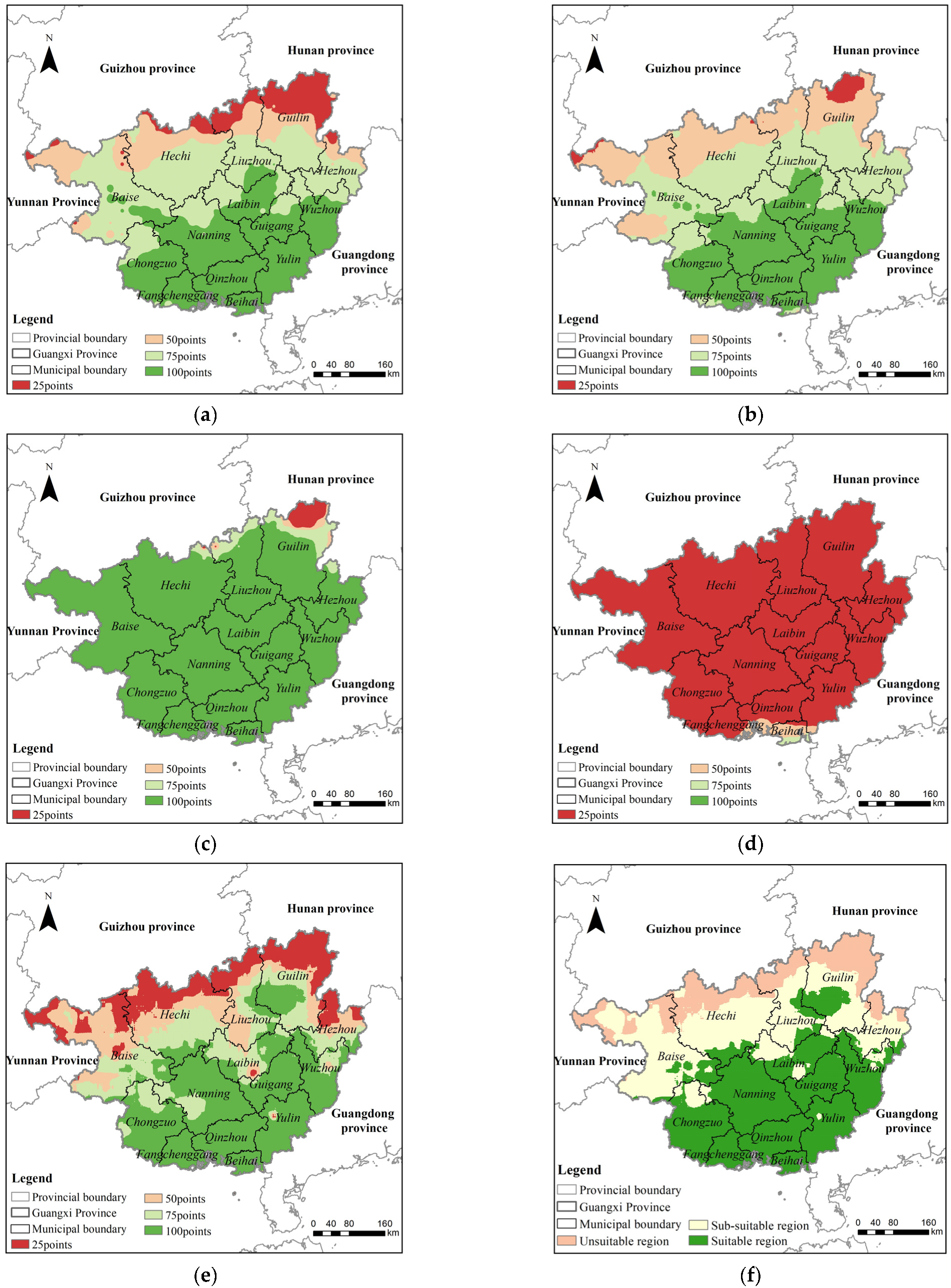
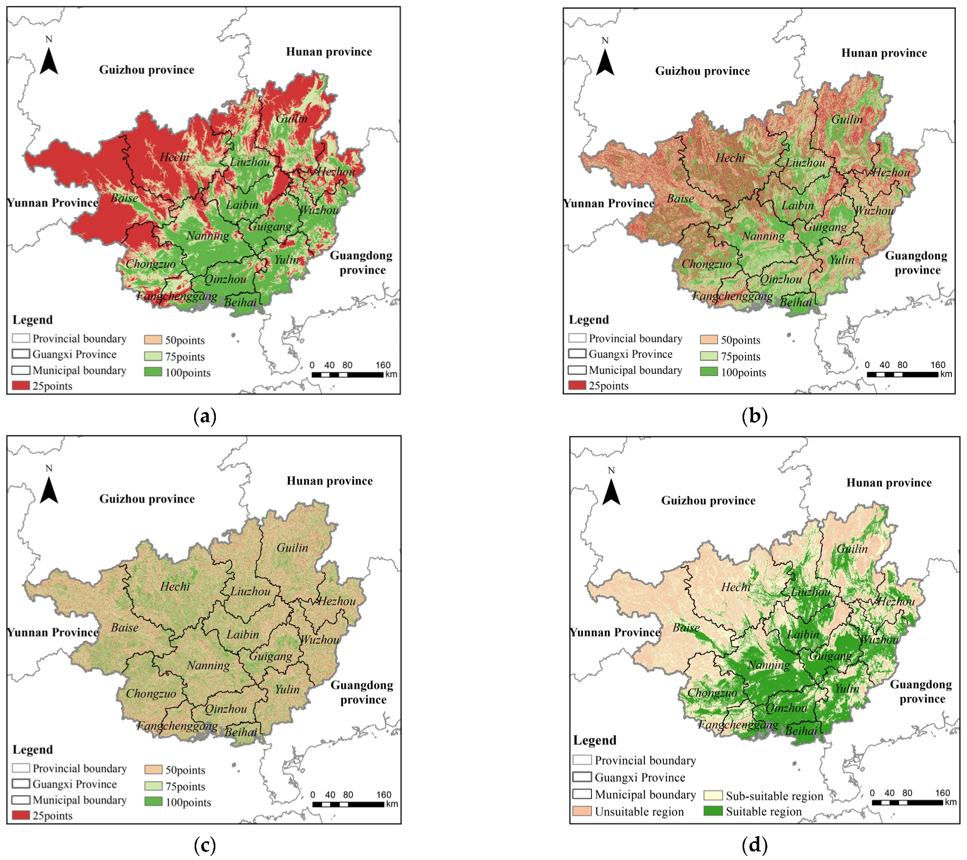
3.1. Assessment of Sugarcane Cultivation Suitability Based on Climatic Factor

Based on the sugarcane cultivation suitability assessment system, the climate factor of sugarcane cultivation suitability in Guangxi Province was assessed. Firstly, the suitability score maps of five indicators were obtained (Figure 3a–e). By considering the weights of each indicator, the assessment score data of sugarcane cultivation suitability in Guangxi Province were obtained based on the climatic factor. Finally, the assessment score data were divided into different levels according to the classification standard for sugarcane cultivation suitability to obtain the assessment results (Figure 3f).
Analysis of Figure 3a–e shows that the northern region of Guangxi Province is mostly mountainous, with lower temperatures and less precipitation, resulting in lower scores for four indicators of sugarcane cultivation suitability, namely the annual average temperature, annual minimum temperature, ≥20 °C accumulated temperature, and precipitation during the period of ≥20 °C. On the other hand, the southern coastal area of Beihai City is heavily influenced by the ocean, with higher and more stable temperatures, resulting in higher scores for the indicator of the number of consecutive days with an average temperature ≥ 25 °C. An analysis of Figure 3f shows that the suitability for sugarcane cultivation in Guangxi Province based on the climatic factor shows a trend of distribution from south to north and along the latitude. Approximately 11.644 million hectares of land are suitable for sugarcane cultivation, mainly distributed in the southern and central regions, accounting for 49% of the total area of Guangxi Province. Approximately 8.188 million hectares of land are moderately suitable for sugarcane cultivation, mainly distributed in the southern part of the northern region, accounting for 35% of the total area. Approximately 3.819 million hectares of land are unsuitable for sugarcane cultivation, mainly distributed in the northern part of the northern region, accounting for 16% of the total area. This is due to the significant differences in climate between the northern and southern regions of Guangxi Province. The northern region is a high-altitude area, with lower temperatures and less precipitation, which is not suitable for growing sugarcane. In contrast, the central and southern regions have suitable temperatures and sufficient precipitation, making them suitable for sugarcane cultivation.

3.2. Assessment of Sugarcane Cultivation Suitability Based on Terrain Factor

Based on the sugarcane cultivation suitability assessment system, the terrain factor of sugarcane cultivation suitability in Guangxi Province was assessed. Firstly, the suitability score map of three indicators were obtained (Figure 4a–c). By considering the weights of each indicator, the assessment score data of sugarcane cultivation suitability in Guangxi Province were obtained based on the terrain factor. Finally, the assessment score data were divided into different levels according to the classification standard for sugarcane cultivation suitability to obtain the assessment results (Figure 4d).
Analysis of Figure 4a–c shows that the northern area of Guangxi Province, certain parts of southwestern Guangxi Province, and certain parts of eastern Guangxi Province are not conducive to sugarcane growth due to high altitude and steep slopes, resulting in lower suitability scores for the altitude and slope indicators in these areas. However, areas such as Hechi City, Chongzuo City, Laibin City, Guigang City, and Beihai City have a relatively flat terrain, more south-facing slopes, and sufficient sunshine, which are conducive to sugarcane photosynthesis and growth. Therefore, the slope direction indicator has a higher suitability score for sugarcane cultivation in these areas. Figure 4d shows that the suitability of sugarcane cultivation in Guangxi Province based on the terrain factor tends to be unsuitable in the northwest and suitable in the southeast, but the distribution is scattered. Approximately 8.205 million hectares of land are suitable for sugarcane cultivation, mainly distributed in the southeastern region, accounting for 34% of the total area of Guangxi Province. About 6.115 million hectares of land are moderately suitable for sugarcane cultivation, scattered near the suitable cultivation areas, accounting for 26% of the total area of Guangxi Province. In addition, approximately 9.332 million hectares of land are unsuitable for sugarcane cultivation, mainly distributed in the northwest region, accounting for 40% of the total area of Guangxi Province. This is due to the general trend of the terrain in Guangxi Province, which is high in the northwest and low in the southeast, with scattered slope orientations. The high terrain in the northwest has lower temperatures and is unsuitable for sugarcane cultivation, while the flat terrain in the southeast has higher temperatures and is suitable for sugarcane cultivation.

3.3. Assessment of Sugarcane Cultivation Suitability Based on Disaster Factor

Based on the sugarcane cultivation suitability assessment system, the disaster factor of sugarcane cultivation suitability in Guangxi Province was assessed. First, the map of suitability scores of three indicators were obtained (Figure 5a–c). By considering the weights of each indicator, the assessment score data of sugarcane cultivation suitability in Guangxi Province were obtained based on the disaster factor. Finally, the assessment score data were divided into different levels according to the classification standard for sugarcane cultivation suitability to obtain the assessment results (Figure 5d).
Analysis of Figure 5a–c shows that there are significant differences in climate and terrain across Guangxi Province, resulting in different levels of disaster risk in different regions. The northwestern region is located in the monsoon climate zone and is particularly vulnerable to the influence of monsoon winds, especially in March; the monsoon airflow blows from the South China Sea, with relatively low relative humidity, dry air, and relatively low rainfall, resulting in a higher frequency of spring drought. The indicator of spring drought frequency has a relatively low score for assessing the suitability of sugarcane cultivation. The central region has a relatively flat terrain with stable airflow and a lack of stimulation of large-scale upward air currents, resulting in less rainfall and a higher frequency of autumn droughts; the indicator of autumn drought frequency has a relatively low score for assessing the suitability of sugarcane cultivation. The northeastern region is located in a high-latitude area with a relatively cold climate and is susceptible to the influence of strong cold air from the north in winter, which can lead to frost occurrences. Therefore, the indicator of frost frequency has a relatively low score for assessing the suitability of sugarcane cultivation. As can be observed in Figure 5d, the distribution of suitable sugarcane cultivation in Guangxi Province based on the disaster factor is suitable for the southern region, with a small part of the western region being unsuitable. Approximately 4.849 million hectares of land are suitable for sugarcane cultivation, mainly distributed in the south, accounting for 20.5% of the total area of Guangxi Province. About 307,000 hectares of land in the western region of Baise City are unsuitable for sugarcane cultivation, accounting for 1.3% of the total area of Guangxi Province. The remaining approximately 18.496 million hectares of land are relatively suitable for sugarcane cultivation, accounting for 78.2% of the total area of Guangxi Province. This is due to the southern region having more rainfall and higher temperatures, with a lower likelihood of spring droughts, autumn droughts, and frost. The complex terrain and lower rainfall in the western region of Baise City result in a higher frequency of spring and autumn droughts.

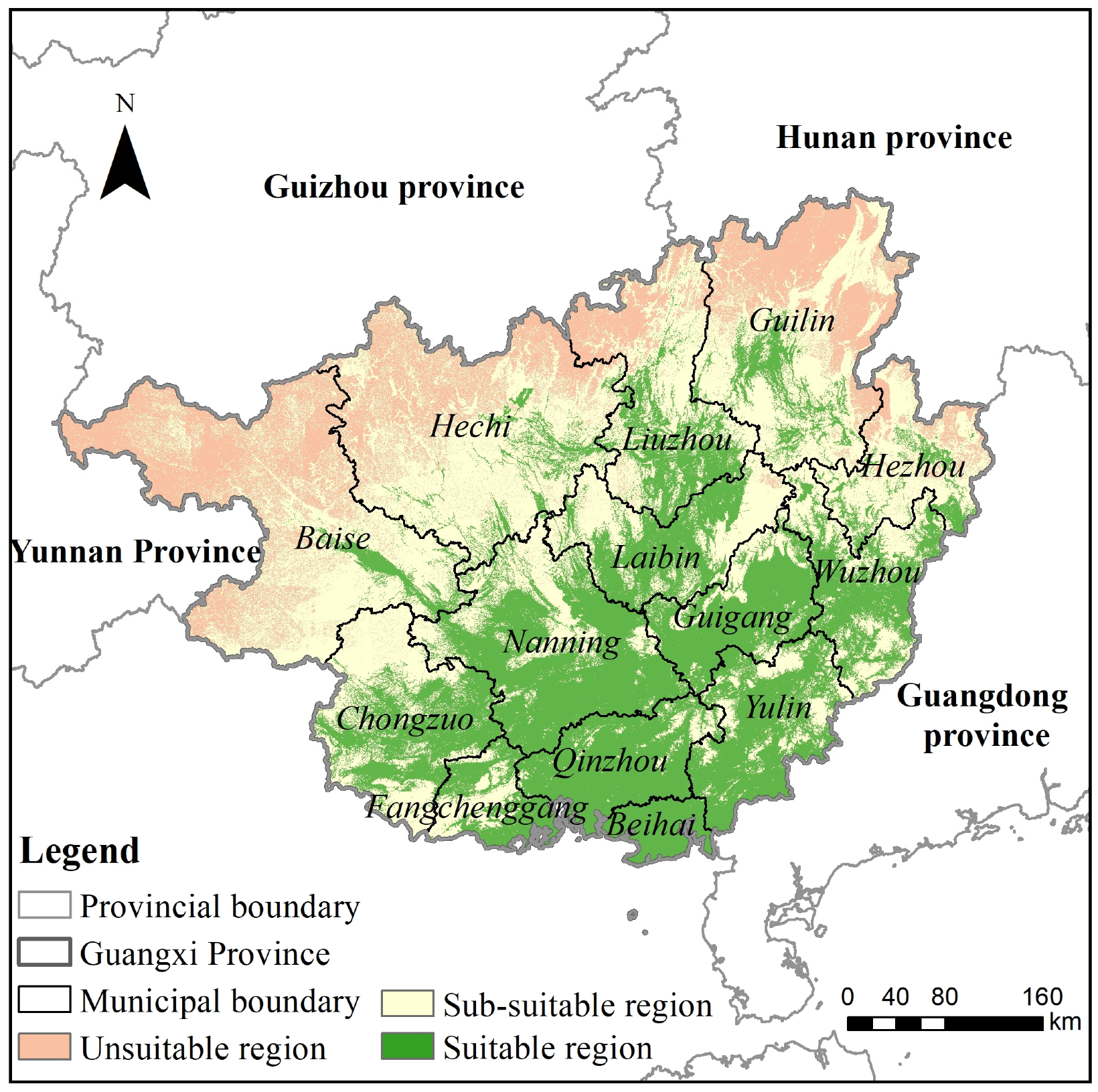
3.4. Comprehensive Assessment of Sugarcane Cultivation Suitability

3.4.1. Analysis of Suitability Assessment for Sugarcane Cultivation

By weighting and summing the score data and weights of the three factors of climate, terrain, and disasters for the suitability of sugarcane cultivation, a suitability score map for sugarcane cultivation in Guangxi Province was obtained. According to the classification standard for sugarcane cultivation suitability, the results of the suitability assessment for sugarcane cultivation in Guangxi Province are shown in Figure 6.
Analysis of Figure 6 shows that 37% of Guangxi Province’s entire area is suitable for sugarcane cultivation, with an area of 8.732 million hectares mainly distributed in the southern and central regions including Qinzhou City, Beihai City, Chongzuo City, Nanning City, Laibin City, Guigang City, and Yulin City. Additionally, 44% of Guangxi Province’s entire area is moderately suitable for sugarcane cultivation, mainly scattered in the central and northern regions, as well as the eastern edge regions, including places such as Baise City, Hechi City, Liuzhou City, and Guilin City, covering an area of 10.292 million hectares. Only 19% of Guangxi Province’s total area is unsuitable for sugarcane cultivation, mainly concentrated in the northern part of Guangxi Province with an area of 4.628 million hectares. Overall, Guangxi Province gradually becomes more suitable for sugarcane cultivation from north to south, with Nanning City, Qinzhou City, Guigang City, Yulin City, Laibin City, and Chongzuo City being the regions with a relatively large suitable area for sugarcane cultivation, which should be areas of focus for the development of the sugarcane cultivation industry. On the other hand, many areas in the northern region are unsuitable for sugarcane cultivation, suggesting that other industries should be developed in these areas.
Comparing the results of our study with Su Yongxiu’s study on the suitability of sugarcane cultivation in Guangxi based on climate and terrain factors, we found that the results of both studies are consistent. Both studies indicate that the northern region is not suitable for sugarcane cultivation, while the central and southern regions are suitable, with the suitability gradually increasing from north to south. The main difference between the two studies is that our results appear more refined on the map due to the use of more detailed data.

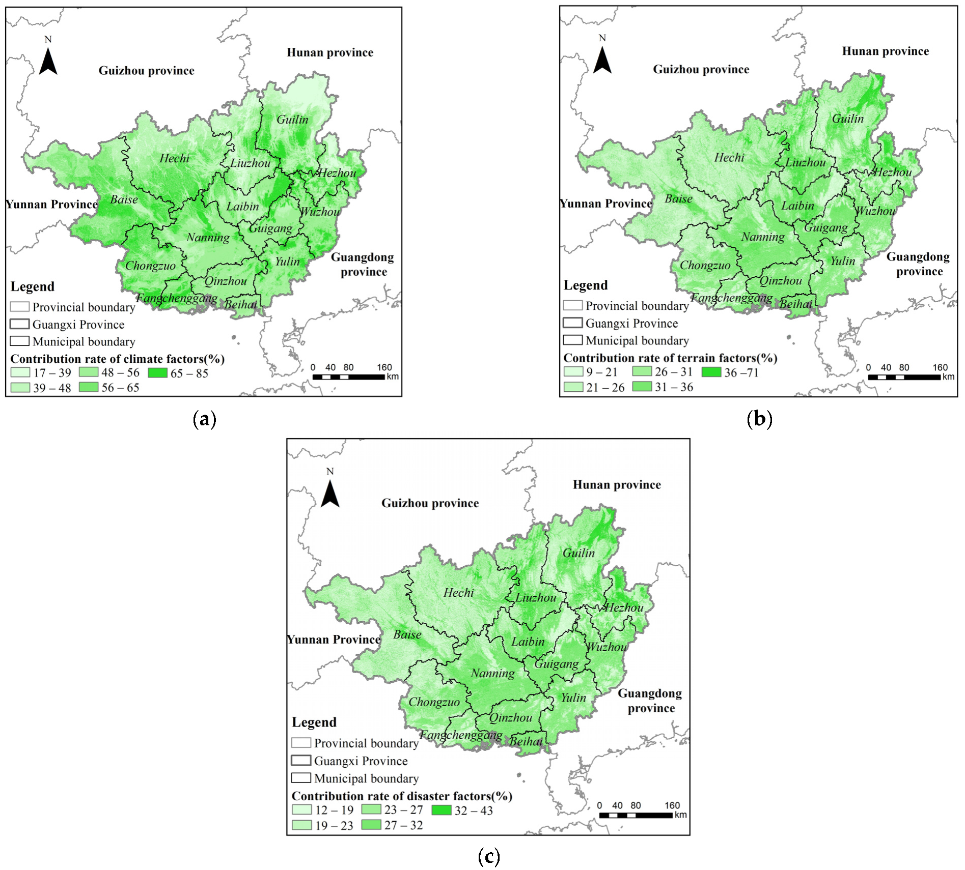
3.4.2. Contribution Rate Analysis of Sugarcane Cultivation Suitability Assessment

In order to better understand the suitability assessment results for sugarcane cultivation in Guangxi Province, this paper used a contribution rate to measure the relative importance of each factor in the assessment. Specifically, the ratio between the score data of a particular factor for sugarcane cultivation suitability and the total sugarcane cultivation suitability score data in Guangxi Province was calculated. Contribution rate calculations were performed for each of the three factors, resulting in three contribution rate maps for the suitability of sugarcane cultivation. These maps are shown in Figure 7.
Analysis of Figure 7 shows that the climate factor has the greatest impact on the suitability assessment of sugarcane cultivation in western Guangxi Province, the southern part of the northern region, and some areas in the eastern region, with contribution rates ranging from 65% to 85%. The terrain factor has the greatest effect on the suitability assessment of sugarcane cultivation in the northeastern region, with contribution rates ranging from 36% to 71%. In contrast, the disaster factor has the greatest impact on the suitability assessment of sugarcane cultivation in the northern region, with contribution rates ranging from 32% to 43%. Therefore, the biggest influencing factor that makes the northern region unsuitable for sugarcane cultivation is disasters, while the impact of the climate factor on this region is relatively small. In contrast, in the central and southern regions, the terrain is the main factor influencing the suitability of sugarcane cultivation, followed by the climate factor. Therefore, targeted management and control in different regions is required to ensure the stable development of sugarcane cultivation.

4. Conclusions and Discussion

This paper comprehensively considered the impact of climate, terrain, and disaster factors on the growth of sugarcane in Guangxi Province and selected 11 indicators as the assessment indicators for sugarcane suitability based on these three factors. AHP and GIS technology were used to construct an assessment system for sugarcane cultivation suitability, and this system was used to assess the suitability of sugarcane cultivation in Guangxi Province. The research results are as follows:
(i) In the suitability assessment system for sugarcane cultivation, 11 specific indicators of climate, terrain, and disaster factors were selected based on their effects on sugarcane growth. Among them, altitude had the highest contribution rate to the suitability of sugarcane cultivation, followed by precipitation during the period of ≥20 °C, slope, and autumn drought frequency. Among the three factors of climate, terrain, and disaster, terrain had the most significant impact on sugarcane cultivation suitability.
(ii) The central and southern regions of Guangxi Province are suitable for sugarcane cultivation, while the northern region is not. The area suitable for sugarcane cultivation is 8.732 million hectares, accounting for 37% of the total area of Guangxi Province. The area that is moderately suitable for sugarcane cultivation is 10.292 million hectares, accounting for 44% of the total area of Guangxi Province. The area unsuitable for sugarcane cultivation is 4.628 million hectares, accounting for 19% of the total area of Guangxi Province.
(iii) It is recommended to focus on the development the sugarcane industry in the regions of central and southern Guangxi Province that are suitable for sugarcane cultivation, such as Chongzuo City, Nanning City, Qinzhou City, Guigang City, Yulin City, and Beihai City. In these areas, the government can strengthen support and guidance for the sugarcane cultivation industry, help farmers improve their cultivation techniques and management skills, and promote the development of local agriculture and economic prosperity. In the northern regions, the government should support other industries to reduce dependence on sugarcane cultivation and ensure sustainable economic development in the area.
This paper assessed the suitability of sugarcane cultivation in Guangxi Province by comprehensively considering three factors: climate, terrain, and disasters, based on previous research. In order to address the issue of frequent disasters caused by extreme weather conditions throughout the year in Guangxi Province, this paper analyzed the impact of disasters on the entire growing season of sugarcane and combined this analysis with the effects of climate and terrain on sugarcane cultivation to provide a more comprehensive assessment of suitability. Additionally, to overcome the problems encountered in the past of using coarse meteorological station data for assessment, this paper used continuous and pixel-level precipitation and temperature data, which are more refined in time and space and can cover the assessment area in more detail, resulting in more detailed assessment results. However, the process of constructing the judgment matrix in the expert rating method relies on the experience of the experts, and the acquisition of weights is subject to some subjective interference. In order to assess the suitability of sugarcane cultivation more scientifically, we will continue to study how to obtain weights to reduce the influence of subjective factors, such as obtaining weights through the autonomous training of neural networks to optimize the assessment system and improve the accuracy of the results.

Author Contributions

Conceptualization, S.C., H.Y. and C.N.; methodology, S.C., H.Y. and C.N.; software, S.C. and C.N.; validation, S.C.; formal analysis, S.C. and C.N.; investigation, S.C., H.Y., H.W. and C.N.; resources, H.Y.; data curation, S.C. and C.N.; writing—original draft preparation, S.C.; writing—review and editing, H.Y. and C.N.; visualization, S.C. and C.N.; supervision, H.Y., J.W. and C.N.; project administration, H.Y. and J.W.; funding acquisition, H.Y. and H.W. All authors have read and agreed to the published version of the manuscript.

Funding

This research was funded by the Innovation Drive Development Special Project of Guangxi (Guike AA20302022), the Youth Innovation Promotion Association CAS (2021119), and the Future Star Talent Program of Aerospace Information Research Institute, Chinese Academy of Sciences (2020KTYWLZX08).

Institutional Review Board Statement

Not applicable.

Data Availability Statement

The data which support the findings of this study are available from the authors upon reasonable request.

Acknowledgments

The authors sincerely thank the editor and anonymous reviewers for their valuable comments and suggestions to improve the quality of this paper.

Conflicts of Interest

The authors declare no conflict of interest.

References

  1. Ji, L.H.; Qin, X.; Wei, G.L. Investigation Report on the Development Status of Sucrose Industry in Hengzhou Guangxi. Adv. Soc. Sci. 2021, 10, 2888–2892. [Google Scholar] [CrossRef]
  2. Virnodkar, S.S.; Pachghare, V.K.; Patil, V.C.; Jha, S.K. Application of machine learning on remote sensing data for sugarcane crop classification: A Review. ICT Analysis and Applications: Proceedings of ICT4SD; Springer: Berlin/Heidelberg, Germany, 2020; Volume 93, pp. 539–555. [Google Scholar]
  3. Silalertruksa, T.; Gheewala, S.H. Competitive use of sugarcane for food, fuel, and biochemical through the environmental and economic factors. Int. J. Life Cycle Ass. 2020, 25, 1343–1355. [Google Scholar] [CrossRef]
  4. Wang, M. Research on Sugarcane Field Recognition Method Based on Support Vector Machine. Master’s Thesis, Guangxi Normal University, Nanning, China, 2020. [Google Scholar]
  5. Deng, S.Q. Sugarcane Cultivation area Extraction and Growth Monitoring Based on NDVI Time Series. Master’s Thesis, Guilin University of Technology, Guilin, China, 2022. [Google Scholar]
  6. Yang, S.D.; Xiao, J.; Liang, T.; He, W.; Tan, H.W. Response of soil biological properties and bacterial diversity to different levels of nitrogen application in sugarcane fields. AMB Express 2021, 11, 172. [Google Scholar] [CrossRef]
  7. Günal, H.; Kılıç, O.M.; Ersayın, K.; Acir, N. Land suitability assessment for wheat production using analytical hierarchy process in a semi-arid region of Central Anatolia. Geocarto. Int. 2022, 37, 16418–16436. [Google Scholar] [CrossRef]
  8. Huang, W.J.; Huang, J.F. Ecological suitability evaluation for torreya crop in Hangzhou city based on a GIS-based fuzzy model. In Proceedings of the 2014 the Third International Conference on Agro-Geoinformatics, Beijing, China, 11–14 August 2014; pp. 1–6. [Google Scholar]
  9. Deng, Q.J.; Chen, Y. Suitability Evaluation of Cold Water Paddy Field for Rice Planting in Jianghan Plain. In Proceedings of the 2015 3rd International Conference on Advances in Energy and Environmental Science, Zhuhai, China, 25–26 July 2015; pp. 1203–1207. [Google Scholar]
  10. Jamil, M.; Ahmed, R.; Sajjad, H. Land suitability assessment for sugarcane cultivation in Bijnor district, India using geographic information system and fuzzy analytical hierarchy process. GeoJournal 2018, 83, 595–611. [Google Scholar] [CrossRef]
  11. Alburo, J.L.P.; Garcia, J.N.M.; Sanchez, P.B.; Cruz, P.C.S. Application of analytical hierarchy process (AHP) in generating land suitability index (LSI) for sugarcane in central Mindanao, Philippines. J. Int. Soc. Southeast Asian Agric. Sci. 2019, 25, 148–158. [Google Scholar] [CrossRef]
  12. Xie, G.X.; Zeng, Z.K.; Li, Y.X.; Qin, Z.L.; Lan, Z.B.; Zhang, X.L.; Xie, F.Q.; Su, Q.Q.; Zhang, J.X. Suitability evaluation of sugarcane cultivation based on land unit. J. South. Agric. 2017, 48, 361–367. [Google Scholar]
  13. Tan, Z.K.; Ou, Z.R.; He, Y. Analysis of main meteorological disasters in Guangxi Province, China sugarcane industry and research on optimization layout of sugarcane industry. Sugarcane Canesugar 2006, 25, 17–21+33. [Google Scholar]
  14. Liu, J.B.; Peng, Y.; Chen, Q.B. Climate Suitability and Regionalization of Sugar Cane Cultivation in Hainan. Chin. J. Agrometeorol. 2009, 30, 254–256. [Google Scholar]
  15. Zhang, Z.; Hu, B.Q.; Jiang, W.G.; Qiu, H.H. Identification and scenario prediction of degree of wetland damage in Guangxi based on the CA-Markov model. Ecol. Indic. 2021, 127, 107764. [Google Scholar] [CrossRef]
  16. Wang, L.D.; Hu, F.; Miao, Y.C.; Zhang, C.Y.; Zhang, L.; Luo, M.Z. Changes in Vegetation Dynamics and Relations with Extreme Climate on Multiple Time Scales in Guangxi, China. Remote Sens. 2022, 14, 2013. [Google Scholar] [CrossRef]
  17. Feng, T.; Chen, H.S.; Polyakov, V.O.; Wang, K.; Zhang, X.B.; Zhang, W. Soil erosion rates in two karst peak-cluster depression basins of northwest Guangxi, China: Comparison of the RUSLE model with 137Cs measurements. Geomorphology 2016, 253, 217–224. [Google Scholar] [CrossRef]
  18. Zhang, J. The state, Capital and Peasantry in the Agrarian Transition of China: The Case of Guangxi Sugarcane Sector. Ph.D. Thesis, Wageningen University and Research, Wageningen, The Netherlands, 2019. [Google Scholar]
  19. Wang, S.; Lian, J.J.; Peng, Y.Z.; Hu, B.Q.; Chen, H.S. Generalized reference evapotranspiration models with limited climatic data based on random forest and gene expression programming in Guangxi, China. Agr. Water Manag. 2019, 221, 220–230. [Google Scholar] [CrossRef]
  20. Su, Y.X.; Li, Z.; Sun, H. Climate zoning for sugarcane cultivation in Guangxi Province, China based on GIS. Chin. J. Agrometeorol. 2006, 3, 252–255+259. [Google Scholar]
  21. Zhang, Y.B.; Fan, X.; Mao, J.; Li, R.D.; Yu, X.L. Study on the spatial distribution characteristics of climate ecology in the main sugarcane producing areas in China. Southwest China J. Agric. Sci. 2021, 34, 2281–2288. [Google Scholar] [CrossRef]
  22. Li, H.S.; Zan, Y.Y.; Jiang, Y.P.; Guo, B.; Li, L.F. Research on refined agricultural climate zoning for sugarcane cultivation in Chongzuo City. Sugarcane Canesugar 2020, 3, 82–86. [Google Scholar]
  23. Li, Y.C.; Xie, Y.H.; Jiang, X.Y. Yunnan Agricultural Science and Technology. Yunnan Agric. Sci. Technol. 2020, 137, 25–27. [Google Scholar]
  24. Aparecido, L.E.D.O.; Moraes, J.R.S.C.; Meneses, K.C.; Torsoni, G.B.; Costa, C.T.S.; Mesquita, D.Z. Climate efficiency for sugarcane production in Brazil and its application in agricultural zoning. Sugar Tech. 2021, 23, 776–793. [Google Scholar] [CrossRef]
  25. Guga, S.; Xu, J.; Riao, D.; Han, A.; Zhang, J.Q. Combining MaxEnt model and landscape pattern theory for analyzing interdecadal variation of sugarcane climate suitability in Guangxi, China. Ecol. Indic. 2021, 131, 108152. [Google Scholar] [CrossRef]
  26. Liang, Y.L.; Yu, S.F.; Zhen, Z.; Zhao, Y.J.; Deng, J.M.; Jiang, W.G. Climatic change impacts on Chinese sugarcane planting: Benefits and risks. Phys. Chem. Earth 2020, 116, 102856. [Google Scholar] [CrossRef]
  27. Srivastava, A.K.; Rai, M.K. Sugarcane production: Impact of climate change and its mitigation. Biodiversitas J. Biol. Divers. 2012, 13, 214–227. [Google Scholar] [CrossRef]
  28. Cui, T.G. Analysis of Topographic Factors for Sugarcane Growing Areas Based on DEM. Master’s Thesis, Guangxi University, Nanning, China, 2018. [Google Scholar]
  29. Li, Y.; Mo, Y.; Are, K.S.; Huang, Z.G.; Guo, H.; Tang, C.; Abegunrin, T.P.; Qin, Z.H.; Kang, Z.W.; Wang, X. Sugarcane planting patterns control ephemeral gully erosion and associated nutrient losses: Evidence from hillslope observation. Agr. Ecosyst. Environ. 2021, 309, 107289. [Google Scholar] [CrossRef]
  30. Huang, C.L. Study on the Impact of Four Meteorological Disasters on Major Crop Yields in Binyang County. Master’s Thesis, Guangxi University, Nanning, China, 2021. [Google Scholar]
  31. Huang, Q.Y.; Qin, Z.H.; Qin, Z.H.; Hu, B.Q. Research progress and prospects on sugarcane disaster monitoring. China Agric. Inform. 2018, 30, 23–40. [Google Scholar]
  32. Yang, F.; Duan, X.W.; Guo, Q.K.; Lu, S.J.; Hsu, K.L. The spatiotemporal variations and propagation of droughts in Plateau Mountains of China. Sci. Total Environ. 2022, 805, 150257. [Google Scholar] [CrossRef]
  33. Luo, W.Z. Climate patterns and countermeasures for frost damage to sugarcane in Guangxi Province, China. Guangxi Sugar Ind. 2000, 1, 5–9. [Google Scholar]
  34. Wu, X.K.; Liu, Z.P.; Tan, Z.K.; Huang, W.J.; Wei, J.F.; Jia, X.F. Study on spatial distribution of low temperature cold frost damage of sugar cane in Guangxi based on Surfer technology. Hubei Agric. Sci. 2019, 58, 30. [Google Scholar] [CrossRef]
  35. Som-Ard, J.; Atzberger, C.; Izquierdo-Verdiguier, E.; Vuolo, F.; Immitzer, M. Remote sensing applications in sugarcane cultivation: A review. Remote Sens. 2021, 13, 4040. [Google Scholar] [CrossRef]
  36. Nohrstedt, D.; Mazzoleni, M.; Parker, C.F.; Baldassarre, G. Exposure to natural hazard events unassociated with policy change for improved disaster risk reduction. Nat. Commun. 2021, 12, 193. [Google Scholar] [CrossRef]
  37. Liu, Y.; Eckert, C.M.; Earl, C. A review of fuzzy AHP methods for decision-making with subjective judgements. Expert Syst. Appl. 2020, 161, 113738. [Google Scholar] [CrossRef]
  38. Díaz, H.; Teixeira, A.P.; Soares, C.G. Application of Monte Carlo and Fuzzy Analytic Hierarchy Processes for ranking floating wind farm locations. Ocean. Eng. 2022, 245, 110453. [Google Scholar] [CrossRef]
  39. McIntosh, R.D.; Becker, A. Applying MCDA to weight indicators of seaport vulnerability to climate and extreme weather impacts for US North Atlantic ports. Environ. Syst. Decis. 2020, 40, 356–370. [Google Scholar] [CrossRef]
  40. Marzouk, M.; Sabbah, M. AHP-TOPSIS social sustainability approach for selecting supplier in construction supply chain. Clean. Environ. Syst. 2021, 2, 100034. [Google Scholar] [CrossRef]
  41. Seyedmohammadi, J.; Sarmadian, F.; Jafarzadeh, A.A.; McDowell, R.W. Development of a model using matter element, AHP and GIS techniques to assess the suitability of land for agriculture. Geoderma 2019, 352, 80–95. [Google Scholar] [CrossRef]
  42. Chen, H.X.; Zhang, Y.W.; Wang, L. A study on the quality evaluation index system of smart home care for older adults in the community—Based on Delphi and AHP. BMC Public Health 2023, 23, 411. [Google Scholar] [CrossRef] [PubMed]
  43. Sato, Y.J.; Tan, K.H. Inconsistency indices in pairwise comparisons: An improvement of the Consistency Index. Ann. Oper. Res. 2022, 1–22. [Google Scholar] [CrossRef]
  44. Teknomo, K. Analytic hierarchy process (AHP) tutorial. Revoledu. Com 2006, 6, 1–20. [Google Scholar]
  45. Šakalys, R.; Sivilevičius, H.; Miliauskaitė, L.; Šakalys, A. Investigation and evaluation of main indicators impacting synchromodality using ARTIW and AHP methods. Transport-Vilnius 2019, 34, 300–311. [Google Scholar] [CrossRef]
  46. Sun, M.; Zheng, W.X.; Duan, X.B. Research on Deep Coal Seam Mining Floor Starta Water Bursting Influenced Factors Based on Analytic Hierachy Process. In Applied Mechanics and Materials; Trans Tech Publications: Pfaffikon, Switzerland, 2014; pp. 737–741. [Google Scholar]
  47. Amenta, P.; Lucadamo, A.; Marcarelli, G. On the transitivity and consistency approximated thresholds of some consistency indices for pairwise comparison matrices. Inform. Sci. 2020, 507, 274–287. [Google Scholar] [CrossRef]
  48. Muñoz, S.J. ERA5-Land hourly data from 1981 to present. Copernic. Clim. Change Serv. Clim. Data Store 2019, 10, 24381. [Google Scholar]
  49. Funk, C.; Peterson, P.; Landsfeld, M.; Pedreros, D.; Verdin, J.; Shukla, S.; Husak, G.; Rowland, J.; Harrison, L.; Hoell, A. The climate hazards infrared precipitation with stations—A new environmental record for monitoring extremes. Sci. Data 2015, 2, 1–21. [Google Scholar] [CrossRef]
  50. Adiri, Z.; Lhissou, R.; Maacha, L.; Jilali, A.; Talbi, E.H.; Jellouli, A.; Chakouri, M. Comparison of ASTER GDEM3, SRTM3, NASADEM, TanDEM-X90, AW3D30, and ALOS PALSAR data with TanDEM-X12: A case study of Tagragra of Akka inlier, Moroccan Anti-Atlas. Arab. J. Geosci. 2022, 15, 1654. [Google Scholar] [CrossRef]
  51. Gorokhovich, Y.; Vustianiuk, A. Implications of slope aspect for landslide risk assessment: A case study of Hurricane Maria in Puerto Rico in 2017. Geomorphology 2021, 391, 107874. [Google Scholar] [CrossRef]
  52. Huang, F.; Tao, S.; Chang, Z.; Huang, J.S.; Fan, X.M.; Jiang, S.; Li, W.B. Efficient and automatic extraction of slope units based on multi-scale segmentation method for landslide assessments. Landslides 2021, 18, 3715–3731. [Google Scholar] [CrossRef]
  53. Albraheem, L.; Alabdulkarim, L. Geospatial analysis of solar energy in riyadh using a GIS-AHP-based technique. Isprs. Int. J. Geo.-Inf. 2021, 10, 291. [Google Scholar] [CrossRef]
  54. Qi, M.M.; Liu, S.Y.; Yao, X.J.; Xie, F.M.; Gao, Y.P. Monitoring the ice phenology of Qinghai lake from 1980 to 2018 using multisource remote sensing data and Google Earth Engine. Remote Sens. 2020, 12, 2217. [Google Scholar] [CrossRef]
  55. Zhang, B.; Niu, Z.G.; Zhang, D.Q.; Huo, X.L. Dynamic Changes and Driving Forces of Alpine Wetlands on the Qinghai–Tibetan Plateau Based on Long-Term Time Series Satellite Data: A Case Study in the Gansu Maqu Wetlands. Remote Sens. 2022, 14, 4147. [Google Scholar] [CrossRef]
  56. Youssefi, F.; Zoej, M.J.V.; Hanafi-Bojd, A.A.; Dariane, A.B.; Khaki, M.; Safdarinezhad, A.; Ghaderpour, E. Temporal monitoring and predicting of the abundance of Malaria vectors using time series analysis of remote sensing data through Google Earth Engine. Sensors 2022, 22, 1942. [Google Scholar] [CrossRef]
  57. Cao, J.; Zhang, Z.; Tao, F.; Zhang, L.L.; Luo, Y.C.; Zhang, J.; Han, J.C.; Xie, J. Integrating multi-source data for rice yield prediction across China using machine learning and deep learning approaches. Agric. Meteorol. 2021, 297, 108275. [Google Scholar] [CrossRef]
  58. Cao, J.; Zhang, Z.; Zhang, L.L.; Luo, Y.C.; Li, Z.Y.; Tao, F.L. Damage evaluation of soybean chilling injury based on Google Earth Engine (GEE) and crop modelling. J. Geogr. Sci. 2020, 30, 1249–1265. [Google Scholar] [CrossRef]
  59. Hu, Q.F.; Li, Z.; Wang, L.Z.; Huang, Y.; Wang, Y.T.; Li, L.J. Rainfall spatial estimations: A review from spatial interpolation to multi-source data merging. Water 2019, 11, 579. [Google Scholar] [CrossRef]
  60. Mitas, L.; Mitasova, H. Spatial interpolation. In Geographical Information Systems: Principles, Techniques, Management and Applications; Wiley: Hoboken, NJ, USA, 1999; Volume 1, pp. 481–492. [Google Scholar]
  61. Wu, C.; Mossa, J.; Mao, L.; Almulla, M. Comparison of different spatial interpolation methods for historical hydrographic data of the lowermost Mississippi River. Ann. Gis. 2019, 25, 133–151. [Google Scholar] [CrossRef]
  62. Odu, G. Weighting methods for multi-criteria decision making technique. J. Appl. Sci. Environ. Manag. 2019, 23, 1449–1457. [Google Scholar] [CrossRef]
  63. Marler, R.T.; Arora, J.S. The weighted sum method for multi-objective optimization: New insights. Struct. Multidiscip. Optim. 2010, 41, 853–862. [Google Scholar] [CrossRef]
  64. Meral, A.; Eroğlu, E. Evaluation of flood risk analyses with AHP, Kriging, and weighted sum models: Example of Çapakçur, Yeşilköy, and Yamaç microcatchments. Environ. Monit Assess. 2021, 193, 505. [Google Scholar] [CrossRef] [PubMed]
Figure 1. Geographical location and elevation distribution map of study area.
Agriculture 13 00988 g001
Figure 2. Sugarcane planting suitability assessment flowchart.
Agriculture 13 00988 g002
Figure 3. Analysis and comprehensive assessment of indicators based on the climate factors: (a) annual average temperature; (b) ≥20 °C accumulated temperature; (c) annual minimum temperature; (d) number of consecutive days with average temperature ≥ 25 °C; (e) precipitation during the period of ≥20 °C; (f) climate factor comprehensive assessment.
Agriculture 13 00988 g003
Figure 4. Analysis and comprehensive assessment of indicators based on the terrain factors: (a) elevation; (b) slope; (c) slope direction; (d) terrain factor comprehensive assessment.
Agriculture 13 00988 g004
Figure 5. Analysis and comprehensive assessment of indicators based on disaster factors: (a) spring drought frequency; (b) autumn drought frequency; (c) frost frequency; (d) disaster factor comprehensive assessment.
Agriculture 13 00988 g005
Figure 6. Distribution map of suitable areas for sugarcane cultivation in Guangxi Province.
Agriculture 13 00988 g006
Figure 7. Contribution rates of three factors to the assessment of sugarcane cultivation suitability: (a) contribution rate of climate factor; (b) contribution rate of terrain factor; (c) contribution rate of disaster factor.
Agriculture 13 00988 g007
Table 1. Indicators system for suitability assessment of sugarcane cultivation in Guangxi Province.
Target LevelCriterion LevelWeightIndicator LevelWeightMost Suitable LevelSuitable LevelModerately Suitable LevelUnsuitable Level
100 Points75 Points50 Points25 Points
Suitability of sugarcane cultivation in Guangxi Province (A)Climate factors (B1)0.31Annual average temperature (C1)/°C0.079(21, +∞)(19, 21](18, 19](−∞, 18]
≥20 °C accumulated temperature (C2)/°C0.245(5000, +∞)(4000, 5000](3000, 4000](−∞, 3000]
Annual average minimum temperature (C3)/°C0.137(0, +∞)(−1.0, 0](−1.5, −1.0](−∞, −1.5]
Number of consecutive days with an average temperature ≥25 °C (C4)/days0.137(150, +∞)(130, 150](110, 130][0, 110]
Precipitation during the period of ≥20 °C (C5)/mm0.402(1200, +∞)(1100, 1200](1000, 1100][0, 1000]
Terrain factors (B2)0.49Altitude
(C6)/m
0.540(−∞, 150](150, 250](250, 350](350, +∞)
Slope
(C7)/°
0.297(−∞, 6](6, 15](15, 25](25, +∞)
Slope direction
(C8)
0.163Flat terrain, southern slopeSoutheastern slopes, southwestern slopesEastern slope, western slope, northeastern slope, northwestern slopeNorthern slope
Disaster factors (B3)0.20Frequency of spring droughts (C9)/%0.297(0, 10](10, 25](25, 50](50, 100]
Frequency of autumn droughts (C10)/%0.540(0, 20](20, 40](40, 60](60, 100]
Frequency of frosts (C11)/%0.163(0, 10](10, 25](25, 50](50, 100]
Table 2. Weight and consistency test results of judgment matrices.
Judgement MatrixCICRJudgement Matrix Weights
A-B0.02680.0462B1:0.31 B2:0.49 B3:0.20
B1-C0.00750.0067C1: 0.079 C2:0.245 C3: 0.137 C4:0.137 C5:0.402
B2-C0.00460.0079C6:0.540 C7:0.297 C8:0.163
B3-C0.00460.0079C9:0.297 C10:0.540 C11:0.163
Consistency test passed
Table 3. Classification standard for suitability of sugarcane plantation.
GradeMost Suitable LevelSuitable LevelModerately Suitable LevelUnsuitable Level
Score/points100[75, 100)[50, 75)[25, 50)
Disclaimer/Publisher’s Note: The statements, opinions and data contained in all publications are solely those of the individual author(s) and contributor(s) and not of MDPI and/or the editor(s). MDPI and/or the editor(s) disclaim responsibility for any injury to people or property resulting from any ideas, methods, instructions or products referred to in the content.

