1. Introduction
Poverty is an extremely serious challenge in the world, and eliminating (or reducing) poverty is a fundamental requirement of human social development. In September 2015, the Sustainable Development Summit, held by the United Nations, adopted Transforming Our World: the 2030 Agenda for Sustainable Development, which sets the 2030 Sustainable Development Goals (SDGS) and proposes to “eliminate poverty in all forms and dimensions” in all parts of the world, by 2030 [
1]. China’s poverty alleviation practice in recent years shows that developing characteristic industries in line with local conditions is the fundamental way to eliminate poverty in rural areas. In China’s rural revitalization strategy, industrial prosperity is the primary requirement for rural revitalization [
2] and the material basis for rural revitalization. The development of characteristic industries depends on the rational development and utilization of land, and land suitability evaluation can provide a basis for the rational use of land and the realization of the characteristic development and utilization of land resources. The characteristic development and utilization of land resources has showed significance in the poverty alleviation of China’s poor counties and poor people [
3] (Yang Zisheng, 2018), and will also play a significant role in promoting the consolidation of poverty alleviation achievements and the rural revitalization strategy being implemented in China.
Land suitability evaluation is a scientific judgment on the suitability and suitability degree of land system use (such as the development of agriculture, forestry, animal husbandry, and fishery) [
4]. In the past 10 years, due to the needs of the development of local characteristic crop industries, the land suitability evaluation of single crop planting has been continuously expanded. The variety of crops involved has also been increasing, and research results have continued to emerge, such as the land evaluation of: the suitability of vegetables [
5,
6,
7,
8], flue-cured tobacco [
9,
10,
11,
12], castanea mollissima [
13], green agricultural product base [
14], oil-tea camellia [
15], jasmine [
16,
17], soy [
18], cotton [
19], wheat and barley [
20], rubber [
21], tea [
22], sugarcane [
23], momordica grosvenorii [
24], cuilan [
25], sisal hemp [
26], kiwifruit [
27], green pepper [
28] and citrus [
29]. They have further enriched and developed the theory and practice of land suitability evaluation for single crop planting, and promoted the development of agricultural characteristic industries.
However, in general, there are not many research results on the land suitability evaluation of individual crops, especially for the characteristic individual land suitability evaluation of promoting poverty alleviation in the poor mountainous areas/rural revitalization of characteristic industries. It can be found from current literature that the existing research results rarely scientifically select the land resource areas of individual crops, based on the land suitability evaluation principles of “suitable planting in the right place” and “suitable growth in the right place”. Additionally, they do not organically link the land suitability evaluation of individual crops with the development of poverty alleviation industries with rural characteristics, so as to promote the increase of production and income of farmers. The land suitability of individual crops was evaluated from the perspective of developing characteristic poverty alleviation industries.
There were many poverty counties in the Jinsha River dry and hot valley area, located in the upper reaches of the Yangtze River, in China [
30]. In terms of climate conditions, the temperature difference in the dry and hot valley area of Jinsha River is small in four seasons, with annual rainfall of 850~1200 mm; however, the dry and wet seasons are distinct, belonging to the subtropical monsoon climate, which is suitable for planting sorghum and other crops. Sorghum likes temperature and light. The suitable temperature for the whole growth period is 20~30 °C [
31], which is mainly distributed in areas with higher temperature and lower latitude. In addition to its edible function, sorghum rice can also be used for brewing liquor, and making sugar, etc. [
32]. In order to win the battle against poverty, since 2017, and in accordance with the general requirements of “a batch of industrial development to alleviate poverty”, Luquan County has taken the planting of sorghum crops as an important industry to reduce poverty and has introduced new sorghum varieties, Hongyingzi No. 1, Hongmaonuo No. 2, and Jinliangnuo No. 1 in the dry hot valley. It has also tried to introduce the “Langzhitang” liquor industry to settle in Luquan, in the form of “enterprise + government + cooperatives + poverty households” to develop large-scale industrialized and characteristic sorghum planting. Based on many surveys with rural cadres, it can be found that the practice of leading the sorghum planting industry to alleviate poverty in the dry and hot valley of the Jinsha River, in Luquan County, has achieved remarkable results [
31]. However, how to scientifically select the land resource area suitable for sorghum planting, according to the land suitability principle of “suitable planting in the right place” and “suitable growth in the right place”, and how to scientifically deploy, arrange, and plan the land for sorghum planting, are topics that need to be studied in depth. For this reason, while drawing on previous research results, and aiming at the shortage of existing literature, this paper takes the dry and hot valley area of the Jinsha River in Luquan County as an example to organically link the evaluation of land suitability of individual crops, with the development of poverty alleviation industries with rural characteristics, thus promoting the increase in production and income of farmers. According to the land suitability evaluation principles of “suitable planting in the right place” and “suitable growth in the right place”, this paper evaluates the land suitability of sorghum planting. On the one hand, this study provides the basis and technical support for Luquan County and other similar poverty relief counties in the Jinsha River dry and hot valley area to carry out rational development, planning, decision-making, and management of sorghum planting industry. On the other hand, the study will explore a scientific, practical, and easy to popularize evaluation principle and method system of land suitability for planting characteristic crops in poor mountainous areas, and further enrich and develop the theory and method system of single land suitability evaluation.
2. Materials and Methods
2.1. Overview of the Study Area
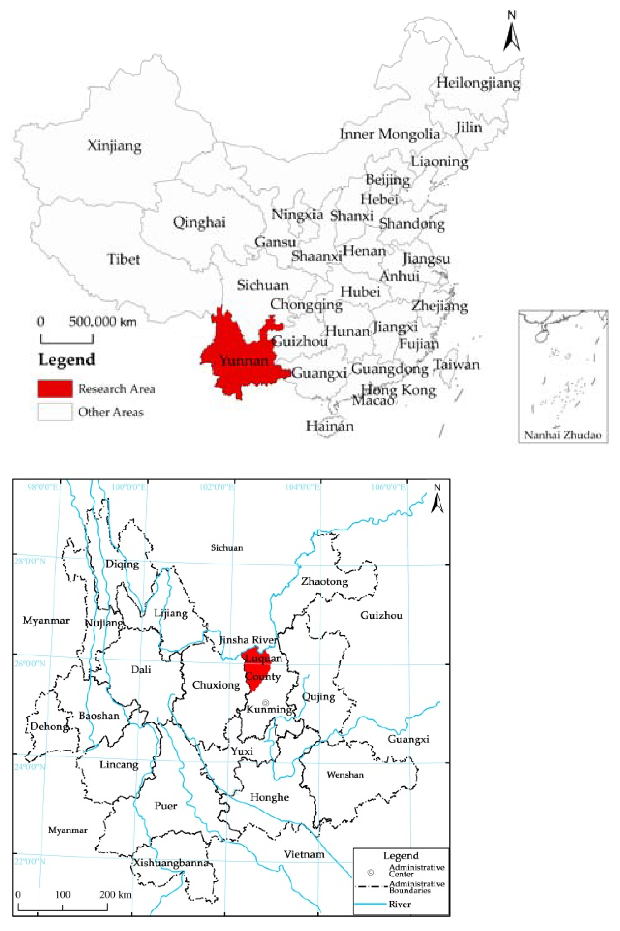
Luquan County is one of the counties under the jurisdiction of Kunming, Yunnan Province, connected with Dongchuan District and Xundian County, in the northwest of Dongchuan District, and in the west of Xundian County. It borders Fumin County in the south and is adjacent to Wuding County of Chuxiong Prefecture in the west. The north is only separated from Huili and Huidong in Sichuan by the “Jinsha River” (
Figure 1). Luquan County covers an area of 4233.91 km
2 and has jurisdiction over 16 streets and towns, namely: Pingshan Street, Cuihua Town, Jiulong Town, Zhuanlong Town, Wumeng Township, Zhongping Town, Xueshan Township, Tuanjie Town, Sayingpan Town, Zehei Township, Maoshan Town, Yunlong Township, Jiaopingdu Town, Malutang Township, Wudongde Town, and Tanglang Township.
Luquan County has more mountains and less flat land. The altitude difference among regions is large, showing very obvious three-dimensional climate characteristics. According to the second land survey of Yunnan Province [
33], the whole area of the county is 423,000 hm
2, while the dam area is 12,000 hm
2, accounting for only 2.8%. The mountainous area is about 411,000 hm
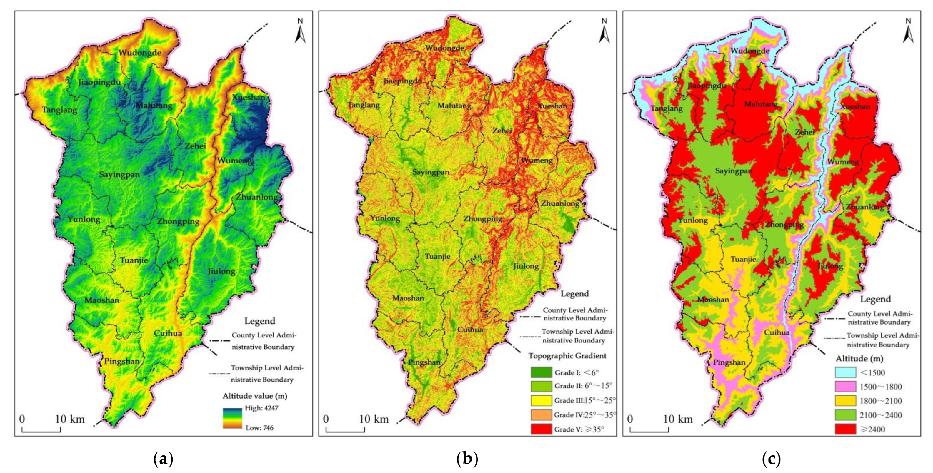
2, accounting for more than 97%. The statistical results of the Luquan Digital Elevation Map show that the land area < 6° only accounts for 5.39%, while the land area of 6°~15°, 15°~25°, 25°~35°, and >=35°, respectively, accounts for 22.62%, 33.83%, 23.30%, and 14.86%. That is to say, the land area over 15° accounts for 72.0% of the whole area, and the land area above the critical slope of 25° accounts for 38.2%. High altitude and steep slope are its obvious characteristics.
Luquan County has a large difference in elevation among different regions, with typical characteristics such as steep slopes and many mountains. This paper applies the Luquan Digital Elevation Map to make statistics of relevant results, and conducts altitude stratification according to <1500 m, 1500~1800 m, 1800~2100 m, 2100~2400 m, and >= 2400 m. The land < 1500 m accounts for 7.47%, 1500~1800 m for 9.39%, 1800~2100 m for 22.16%, 2100~2400 m for 32.66%, and >= 2400 m for 28.31%.
The results of the second soil survey in Luquan County show that the soil in the county is mainly red soil, purple soil, and yellow brown soil [
34]. Due to the large altitude difference in the territory, the vertical distribution of soil is very prominent, and its types are regularly distributed with the elevation.
2.2. Evaluation Index System
Based on the basic concept of land and the land attributes or land property factors representing land quality, the commonly used evaluation indicators in past agricultural land suitability evaluation mainly include soil, ecology, landform, slope, vegetation, and the climate of the region. The scope of assessment determined in this study is the existing irrigated land, dry land, and other grasslands below 1800 m above sea level in the Jinsha River basin of Luquan County, excluding forest land, paddy field, garden plot, other agricultural land, various construction land, waters, and bare land. The evaluation area is 27,877.59 hectares. Since the evaluation unit used is the land plot of the county level land use change survey, that is, the “current land use map spot” in the 1:10,000 current land use map in Luquan County, the need for evaluation and the availability of basic data related to the evaluation unit need to be fully considered in the selection of evaluation indicators. After investigation and analysis, among many factors affecting the suitability of sorghum planting land, some are rigid, such as low temperature, and steep slope, etc. The other part is the basic factors affecting sorghum planting, such as hydrology, and soil texture, etc. There are also some factors that belong to dual factors, such as terrain slope. Generally speaking, the gradient can be 25° as the critical point. If the gradient exceeds 25°, it indicates that the gradient is too steep. 25° is the upper limit of reclamation forbidden slope specified in the Law of the People’s Republic of China on Water and Soil Conservation [
35]. For cultivated crops, including sorghum, when the slope reaches 25°, the instability of various objects on the slope is very high. Especially in the rainy season (even heavy rain and rainstorm), objects on the slope, under the combined effect of their sliding potential energy, raindrop kinetic energy, runoff scouring force, and other forces, usually have a great danger of sliding down, often causing serious water and soil loss. This will cause serious damage to the ecological environment in mountainous areas. Therefore, the land is considered unsuitable for planting crops and is classified as “unsuitable” (i.e., the method of “one vote veto” is adopted). If the gradient is within 25°, the land suitability can be comprehensively evaluated as a participating factor, together with other participating factors. Therefore, it is necessary to combine some special factors with other basic elements in the suitability evaluation of sorghum planting land, so as to build a scientific and reasonable indicator evaluation system. At the same time, the method of “one vote veto” is adopted for these special factors (such as slope), so as to finally ensure the scientificity and rationality of the suitability evaluation results. According to the investigation and analysis, and in accordance with the characteristics of sorghum planting, this study takes into account the availability, scientificity and rationality of the data, the terrain slope, elevation (thermal conditions), soil layer thickness, soil texture, the degree of water source assurance, drainage conditions, bare rock ratio, and average unit yield in recent three years, and they are used as the evaluation factors for suitability evaluation. An index system for the suitability evaluation of sorghum planting land is constructed (
Table 1).
In this paper, various evaluation indicators are divided into four grades, which are high, medium, low appropriate, and inappropriate (
Table 1). For example, for the slope, the reference values corresponding to the above four grades are, respectively: less than 6°, 6°~15° (including 6° but excluding 15°), 15°~25° (including 15° but excluding 25°), and greater than or equal to 25°.
It should be pointed that environmental factors, such as biodiversity protection, natural capital protection, and carbon sequestration, are also important. However, since the assessment unit is the land plot for land use change survey at the county level, the basic data and data required are still difficult to obtain, so this paper will temporarily not consider them. In addition, this paper does not include vegetation mapping (e.g., forests, shrubs, and grasslands), because the evaluation scope selected in this paper is the existing irrigated land, dry land, and other grasslands below 1800 m above sea level, excluding forest land, paddy field, garden land, and grassland. This is due to the following considerations: newly reclaimed land suitable for planting sorghum cannot compete with forest land and grassland. That is to say, the existing forest land and grassland need to be kept for their functions, which is also the basic requirement of land use regulation in China. If a large amount of forest land and grassland are reclaimed as sorghum planting land, the ecological environment will be degraded or even seriously deteriorated.
2.3. Evaluation System
A reasonable and scientific system is the key to evaluate land suitability. Based on FAO [
36] and the land resource suitability evaluation system [
37] of China’s 1:1,000,000 land resource map, this paper divides the land suitability evaluation system for sorghum planting into three levels, namely: suitability program, suitability class, and restricted type, according to the actual needs of carrying out sorghum planting land suitability evaluation.
The suitability index can indicate the suitability type of sorghum planting land and whether the land is suitable for sorghum planting. It can be divided into “suitable” and “unsuitable”.
(1) Suitability (S): This means that continuous sorghum planting on the land will not only not cause damage to the land itself, but will also produce significant development and utilization benefits. The land assessed as “suitable for planting sorghum” belongs to “suitable for planting sorghum”.
(2) Unsuitable (N): This means that the land cannot be used for “sorghum planting”. The main reasons for unsuitability are: ➀ The natural conditions of the land are bad, such as steep terrain, high altitude, or thin soil layer, which strongly limits the possibility of sorghum planting. ➁ The development of land as sorghum planting land may lead to some troubles, such as obvious ecological environment damage and soil degradation. ➂ The land conditions are poor in all aspects, so that the input is more and the income is less, even the income is far less than the input. The land assessed as “unsuitable” belongs to “unsuitable sorghum land”.
- 2.
Suitability level
It is within the scope of “suitability program”, reflecting the suitability of the land for the use of “sorghum planting”. The classification of suitable levels can be divided into three levels by referring to the existing common practices at home and abroad, namely:
(1) Highly suitable grade (first-class suitable land for planting) (S1): the land can be continuously used for “sorghum planting”. There are no obvious restrictions or only small restrictions on the way to use it, which will not significantly affect the development and utilization benefits, nor the need to increase investment beyond an affordable level.
(2) Moderate suitability level (second-class suitable land for planting) (S2): the land can be continuously used for “sorghum planting” and is subject to moderate restrictions, so the development and utilization benefits are reduced, and the suitability level is “medium” or “moderate”. Such land can only be developed as “sorghum planting land” after certain transformation and improvement, or it needs to be properly protected and managed to prevent land degradation.
(3) Low suitability grade (third-grade suitable land for planting) (S3): land that can be continuously used for “sorghum planting” and is severely restricted, so the development and utilization benefits are significantly reduced, and the suitability degree is “low”. Such land can only be developed into “sorghum planting land” after major transformation and remediation measures are taken, or strict protection and management measures are required, otherwise, land degradation is very likely to occur.
- 3.
Restricted
“Restricted” is within the category of “suitable level”, which is mainly classified according to the strength of its restrictions and the difference of factors. For the same restricted type, the transformation measures and restrictive factors are generally the same. Within the same “level”, there is no essential difference between the “restricted types”. On this basis, the difficulty, direction, and measures of land transformation can be clarified. In general, the limiting factors are relatively stable in the long run, and some volatile factors can be ignored.
As far as the suitability evaluation of sorghum planting land is concerned, the limitation types are mainly divided into: terrain slope limitation, altitude (heat) limitation, soil layer thickness limitation, soil quality limitation, water source assurance degree limitation, drainage condition limitation, bare rock limitation, water supply and drainage condition limitation, and unit yield limitation, etc. Each limiting factor can be divided into several levels, and the indicators should be able to meet the classification of sorghum planting suitability as the basic criterion.
2.4. Evaluation Method and Model Construction
In view of the vulnerability of the ecological environment in the Jinsha River basin and the sustainability of regional industrial development, this paper fully combines the “limit condition method” and the “suitability index method” to calculate and evaluate whether each plot is suitable for sorghum planting and the degree of suitability, according to which the above four evaluation grades are divided. The technical steps of evaluation include:
- 1.
The “limit condition method” was used to determine the suitability and unsuitability of each evaluation unit for sorghum planting. The above three special factors are mainly considered. It is stipulated that any plot with a slope of 25° or more, or located at an altitude of more than 1800 m and a soil layer thickness of less than 20 cm, shall be regarded as unsuitable for sorghum planting. On the contrary, it is considered as suitable sorghum land.
- 2.
Combined with “limit condition method” and “suitability index method” as the main body, determine the appropriate grade of sorghum suitable for planting. First, the first-grade sorghum suitable land was determined by using the limit condition method. With reference to the research methods of various scholars, as long as the slope is lower than 6°, the natural conditions in all aspects are relatively good in the “sorghum suitable land”, which is determined as the first-class sorghum suitable land in this paper. Second, the second and third-grade sorghum suitable fields were determined by using the method of suitability index. The specific steps are:
- ➀
Determine the single evaluation factor index. In this paper, the definition domain of each single evaluation factor index is determined at [0, 100]. Because it is difficult to quantify each non quantitative assessment factor accurately, this paper assigns the values of 85, 65, and 45, respectively, according to the high, medium, and low land suitability grades corresponding to each assessment factor (
Table 2).
- ➁
Calculate and establish the comprehensive suitability index of sorghum planting. Referring to previous research methods, this paper proposes a comprehensive evaluation index (comprehensive suitability index of sorghum planting land) to characterize the suitability of sorghum planting. The purpose is to evaluate the suitability of sorghum planting land more scientifically and reasonably. The calculation method is as follows:
In the above formula, I1, I2,..., I8 represent the evaluation index values of 8 factors evaluating the suitability of sorghum planting land. w1, w2,..., w8 represent the weight values of I1, I2,..., I8. The higher the comprehensive suitability index of sorghum planting land, the more suitable the land is for sorghum planting.
Generally, each indicator has a different impact on the overall, so the weight of each indicator should be determined when making a comprehensive evaluation of the overall. This paper uses the Delphi method to calculate the weight, and organizes 15 experts from various industries to score the weight of the eight evaluation factors in
Table 1, and obtains the weight value (
Table 3).
- ➂
Determine the comprehensive suitability level. This paper determines the weight according to the Delphi method, calculates the value of the final comprehensive suitability index of sorghum planting using GIS, and divides the comprehensive suitability grade of each sorghum planting evaluation spot. In this paper, the criteria for the classification of the three grades of suitable land for sorghum planting are established (
Table 4).
2.5. Determination of Evaluation Scope and Selection of Evaluation Unit
The scope of suitability evaluation of sorghum planting land in the dry hot valley of Luquan County is determined from two aspects.
First of all, according to the development practice of the sorghum industry in Luquan County, the regional scope of this study is mainly aimed at the valley and mountain area of the Jinsha River basin in Luquan County, below 1800 m above sea level, with an area of 71,409.07 hectares, accounting for 16.87% of the county. These areas are mainly distributed in 13 townships and 28 village committees in Luquan County.
Secondly, from the perspective of current land types, the objects of this assessment are determined as two categories: first, irrigated land and dry land in cultivated land. Second, other grasslands, that is, wasteland [
38,
39,
40] in the previous land use classification system, belonging to reserve land resources. This is due to the following considerations: First, do not compete with forest land, paddy fields in cultivated land, garden plots, other agricultural land, and various types of construction land. Second, the reserve land resources mainly consider other grasslands (uncultivated grasslands), and the water area, bare land, and other areas, should not be used for sorghum planting. Therefore, paddy field, garden plot, forest land, various construction land, water area, and bare land, etc. in the cultivated land are not evaluated as “suitable for sorghum planting”, but are considered as “unsuitable for sorghum planting”. According to the land change survey data, completed in 2019, the area of irrigated land and dry land below 1800 m above sea level in the county is 8557.76 hectares, and the area of other grasslands (uncultivated grassland) is 19,319.84 hectares, with a total assessment area of 27,877.59 hectares, accounting for 39.08% of the land area below 1800 m above sea level in the Jinsha River basin (
Table 5).
Evaluation Scope of Land Suitability of Sorghum Planting in Jinsha River Basin of Luquan County
The evaluation unit, also known as the evaluation object, is the smallest unit in land suitability evaluation. Its spatial boundaries are very clear. This spatial entity is formed by the combination of various impact factors. In general, the same evaluation units have the same basic land characteristics, that is, their land production level and natural characteristics are consistent. On the contrary, inconsistent evaluation units have different basic land characteristics, such as different land use methods and management characteristics. The evaluation unit is a spatial entity reflecting the final results of sorghum planting suitability evaluation, and its selection and classification are usually restricted by the accuracy of the survey.
Based on the needs of this sorghum planting land suitability evaluation, and in combination with the local characteristics of Luquan County, the evaluation unit in this paper mainly uses the land plots from the county level land use change survey. In other words, this paper uses the “current land use map spot” in the 1:10,000 current land use map. If the area of the spot is too large and covers multiple grade grades, this paper divides the spot into multiple evaluation units according to four grade grades (i.e., below 6°, greater than or equal to 6° and less than 15°, greater than or equal to 15° and less than 25°, greater than or equal to 25°) as the boundary.
2.6. Data Sources
The sources of various basic data and maps in the suitability evaluation of sorghum planting land in Luquan County are as follows:
(1) The first vector database of land use status change survey is from the vector database of land use status change survey of Luquan County in 2018, completed by the Luquan County Bureau of Land and Resources (now Luquan County Bureau of Natural Resources) in 2019. Second, from the website of the Resource and Environmental Science and Data Center of the Chinese Academy of Sciences (
https://www.resdc.cn/) (accessed on 18 October 2021) download the DEM image of 30 m spatial resolution of Luquan County in 2000, and use ArcGIS software to revise the vector data of the 2018 Luquan County land use status change survey, obtain the 2020 land use status change data, and form the latest 1:10,000 land use status map of Luquan County.
(2) The gradient classification map and elevation classification map are downloaded from the geospatial data cloud to obtain the digital elevation model map of Luquan County. The digital elevation model map of Luquan County is obtained by using mask interception in GIS tools, and then the topographic gradient classification map and elevation classification map of Luquan County are generated.
(3) The soil type distribution map is derived from the soil distribution map of Luquan County (1:50,000) prepared by the Second Soil Census Office of Luquan County, and the soil distribution map of Kunming City (1:200,000) prepared by the Second Soil Census Office of Kunming City. Relevant soil attribute data are from Luquan Soil compiled by the Second Soil Census Office of Luquan County and Kunming Soil, compiled by the Second Soil Census Office of Kunming.
3. Results
3.1. Results of Topographic Gradient and Elevation Classification in Luquan County
Due to the limitation of space, according to the evaluation factors and grading indicators for the suitability of sorghum planting land, this paper has drawn the altitude map of Luquan County (
Figure 2a), the topographic gradient grading map of Luquan County (
Figure 2b), and the elevation grading map of Luquan County (
Figure 2c). According to these results, we can directly see the suitability evaluation scope of this paper.
3.2. Evaluation Results
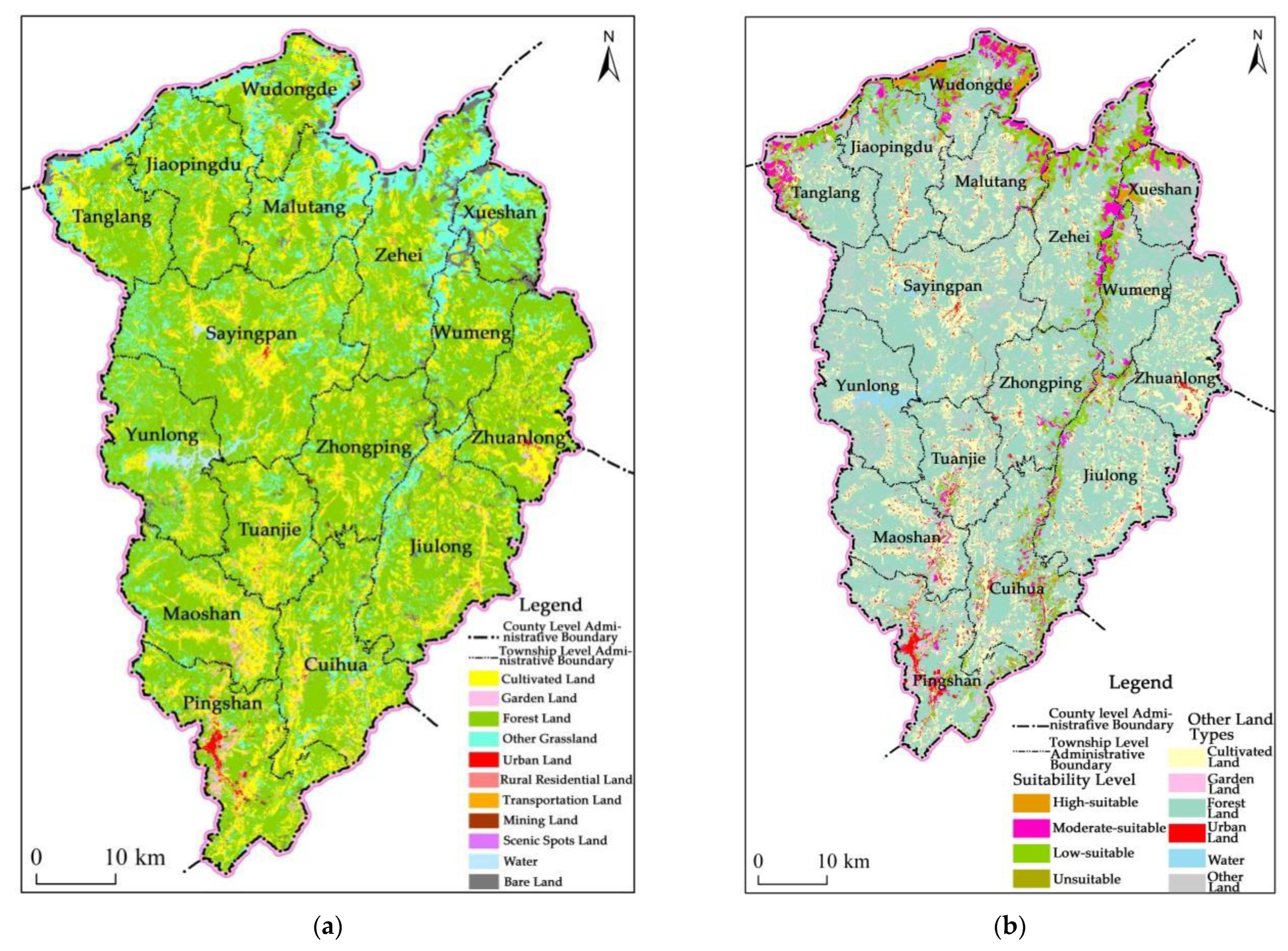
According to the vector database data of land use status change survey obtained, this paper uses the ArcGIS software to revise the vector data of land use status change survey in Luquan County in 2018, obtain the data of land use status change in 2020, and form the latest 1:10,000 land use status map of Luquan County (
Figure 3a).
According to the above evaluation methods and steps, the ArcGIS 10.5 was used to evaluate the suitability of sorghum planting in each evaluation map spot within the evaluation scope of Luquan County, and the sorghum planting suitability grade area (
Table 6,
Table 7 and
Table 8) in the Jinsha River basin of Luquan County and the sorghum planting land suitability evaluation map (
Figure 3b) in the Jinsha River basin of Luquan County were obtained.
Although
Table 6,
Table 7 and
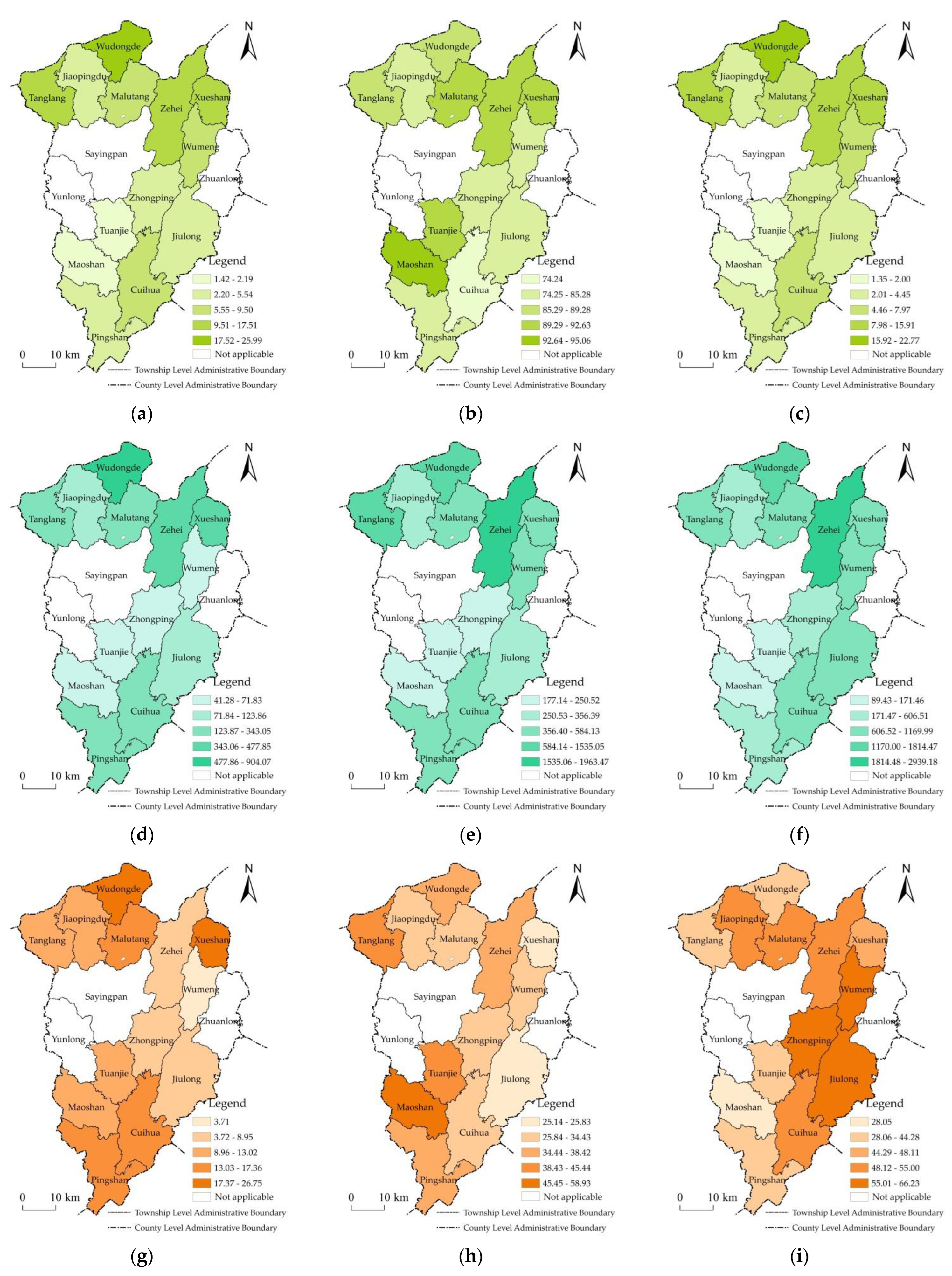
Table 8 clearly show the total land area suitable for planting sorghum in the townships of Luquan County, and the land area of each suitable grade, it is difficult for us to directly see the differences among regions. Additionally, because of the geographical location constraints, it is difficult for us to clearly understand whether these differences have a certain spatial agglomeration characteristics. For this reason, this paper has drawn: the proportion of the evaluation scope of the land suitable for planting sorghum to the total land area in Luquan County (
Figure 4a); the proportion of land suitable for planting sorghum in the evaluation scope in townships of Luquan County (
Figure 4b); the proportion of land suitable for planting sorghum in total land area in townships of Luquan County (
Figure 4c); the land area (
Figure 4d–f) of each suitable grade (first-class suitable, second-class suitable, third-class suitable); and the proportion of the land area of each suitable grade (
Figure 4d–f).
3.3. Evaluation Results
3.3.1. Analysis on the Suitability Grade Area and Proportion of Sorghum Planting Land in the County
The evaluation results show that, within the evaluation scope (i.e., 27,877.59 hectares of irrigated land, dry land, and other grasslands below 1800 m above sea level in the Jinsha River basin of Luquan County), the area of land suitable for planting in the whole county is 24,227.61 hectares, accounting for 86.91% of the evaluation scope. The area of unsuitable land is 3649.98 hectares, accounting for 13.09% of the assessed area. There is an obvious gap between the area and proportion of land suitable for farming and land unsuitable for farming in each township (
Table 8).
Among the land suitable for farming in the county, the first-class land suitable for farming is 3366.57 hectares, accounting for 13.90% of the land suitable for farming. The second-class suitable land is 8540.25 hectares, accounting for 35.25% of the suitable land. The third-class suitable land is 12,320.79 hectares, accounting for 50.85% of the suitable land. It can be seen that the land suitable for planting in the county is mainly the third-class land, and the proportion of the first, second and third-class land suitable for planting is about 14:35:51. There are obvious differences in the area and proportion of different classes of land suitable for planting in each township (
Table 8).
Based on statistics and analysis of the database of the evaluation results of the suitability of sorghum planting land in the Jinsha River basin of Luquan County, the composition of the limiting factors of unsuitable land is as follows:
(1) The slope is more than 25°, accompanied by very obvious water and soil loss, with an area of 1886.45 hm2, accounting for 51.68% of the area of land unsuitable for planting.
(2) Due to the restriction of soil thickness, soil texture and bare rock, the area of land unsuitable for planting is 1763.53 hectares, accounting for 48.32% of the area of land unsuitable for planting.
The above suitability evaluation results show that Luquan County needs to include the steep slope land with more than 25°, and the land that is not suitable for planting sorghum due to other factors, into the scope of ecological protection, so as to better prevent the damage and environmental pollution caused by artificial planting of crops and continuous land development. This is because steep slopes over 25° are prone to serious water and soil loss, which is the scope of land reclamation prohibited by the Law of the People’s Republic of China on Water and Soil Conservation [
35] and the scope of strengthening ecological protection. In addition, the land that is not suitable for planting sorghum due to other factors is mainly shallow soil layer, has poor soil texture, and a large proportion of bare rock. The ecological degradation of the low-quality land is prominent, and it really needs to strengthen ecological restoration and protection. For land within 25°, ecological protection shall be taken into consideration while development and utilization, so as to maximize ecological, economic and social benefits. At the same time, water and soil conservation technology projects will be used to realize the sustainable use of land resources.
3.3.2. Analysis on the Suitability Grade Area and Proportion of Sorghum Suitable for Irrigated Land and Dry Land
Among the 8557.76 hectares of irrigated and dry land below 1800 m above sea level in the Jinsha River basin of Luquan County, 6208.26 hectares are suitable for planting sorghum, accounting for 72.55%. The area unsuitable for planting is 2349.49 hectares, accounting for 27.45%. There is an obvious gap between the area and proportion of land suitable for farming and land unsuitable for farming in each township (
Table 6). In the area of irrigated land and dry land suitable for planting sorghum below 1800 m above sea level in the Jinsha River basin of the county, 307.45 hectares are first-class suitable for planting, accounting for 4.95% of the suitable land. The second-class suitable land is 2726.93 hectares, accounting for 43.92% of the suitable land. The third-class land suitable for planting is 3173.88 hectares, accounting for 51.12% of the land suitable for planting. It can be seen that the area of irrigated land and dry land suitable for planting sorghum in the county is also dominated by the third-class suitable for planting, and the proportion of the first, second and third-class suitable for planting is about 5:44:51. There are great differences in the area and proportion of different classes of irrigated and dry land suitable for planting in different towns (
Table 6).
3.3.3. Analysis on the Suitability Grade Area and Proportion of Sorghum Suitable for Other Grasslands
It can be seen from
Table 7 that in 19,319.84 hectares of “other grasslands” in the Jinsha River basin of Luquan County below 1800 m above sea level, the area suitable for planting sorghum is 18,019.35 hectares, accounting for 93.27%. The unsuitable planting area is 1300.49 hectares, accounting for 6.73%. There is an obvious gap between the area and proportion of land suitable for planting and land unsuitable for planting in each township (
Table 7). Among the 18,019.35 hectares of other grasslands suitable for planting sorghum in the county, 3059.12 hectares are of first-class land, accounting for 16.98%. The second-class land suitable for planting is 5813.32 hectares, accounting for 32.26%. The third-class land suitable for planting is 9146.91 hectares, accounting for about 50.76%. It can be seen that the other grasslands suitable for planting sorghum are mainly of the third-class, and the proportion of the first, second and third-class is about 17:32:51. There is a great difference in the area and proportion of different classes of other grassland suitable for sorghum planting in each township (
Table 7).
3.4. Application Mode of Evaluation Results in the Development of Characteristic Industries
The above evaluation results show that the valley and the slopes on both sides of the Jinsha River basin in Luquan County below 1800 m above sea level belong to the dry and hot valley area of the Jinsha River. There is a wide land suitable for sorghum planting. The area of land suitable for sorghum planting is 24,227.61 hectares, while that of Zehei, Wudongde, Tanglang, Cuihua, Xueshan, Malutang, Wumeng, Pingshan, Jiulong, and Jiaopingdu (10 towns in total) is more than 1000 hectares. Since 2017, Luquan County has tried to use the poverty alleviation model of “enterprise + government + cooperatives + poor households”, introduced the “Langzhitang” liquor industry to settle in the county and build factories, developed large-scale, industrialized, and characteristic sorghum planting, and achieved a stable income increase for farmers, and has achieved remarkable results. By the end of 2020, the area of sorghum planting in Luquan County has exceeded 1200 hectares. In accordance with the Implementation Plan for the Development of High-quality Sorghum Industry in Luquan Yi and Miao Autonomous County (2018–2020), and the relevant plans of the “Fourteenth Five Year Plan”, the scale of high-quality sorghum planting will be greatly expanded in the future. Since January 2021, the author has followed the third party assessment team to Luquan County many times to investigate the development and layout of the assistance industry, and has communicated in-depth with the county party and government leaders, the Agricultural and Rural Bureau, and the Rural Revitalization Bureau (the former Poverty Alleviation and Development Office), to jointly discuss the necessity and feasibility of further development and expansion of the sorghum planting industry. The author believes that in accordance with the principles of “adjusting measures to local conditions” and “suitable planting in the right place” and “suitable growth in the right place”, based on the suitability evaluation of sorghum planting land, scientifically developing the high-quality sorghum industry layout according to the appropriate scope of sorghum planting is of great practical significance for consolidating the achievements of poverty alleviation and implementing the rural revitalization strategy.
In order to win the battle against poverty, Luquan County, in accordance with the general requirements of the industrial development for poverty alleviation in the “five-pronged poverty alleviation measures”, takes industrial poverty alleviation as the primary work, and makes every effort to develop a characteristic planting industry to promote farmers’ income increase and poverty alleviation. In combination with the climate characteristics of the Jinsha River valley area in Luquan and the previous small-scale planting experience, since 2017 Luquan County has introduced new sorghum varieties Hongyingzi 1, Hongmaonao 2, and Jinliangnao 1, to the dry and hot valley region. Focusing on the fundamental poverty alleviation path of industrial poverty alleviation, it has taken sorghum planting as a key industrial poverty alleviation project, The Implementation Plan for the Development of Hig- quality Sorghum Industry in Luquan Yi and Miao Autonomous County (2018–2020) was formulated and issued. In the form of “enterprise + government + cooperatives + poverty households”, the “Langzhitang” liquor industry was introduced to settle in Luquan, build a factory, develop large-scale, industrialized and characteristic sorghum planting, and take policy measures to protect price acquisition, so as to promote farmers (especially poverty households) to increase production and income and promote industrial prosperity.
Figure 5 intuitively shows the sustainable mode of poverty alleviation led by the sorghum planting industry in Luquan County.
The application of the evaluation results of sorghum planting land suitability in the development of high-quality sorghum industry is mainly reflected in the key link of “rational layout of new sorghum planting land”. The basic meaning of the so-called “rational layout” is that the new sorghum planting land should be arranged within the scope of gentle slope suitable for planting with suitable ecological environment conditions. That is to say, the spatial distribution range of the new sorghum planting land is consistent with the distribution range of suitable planting land determined in the “Sorghum Planting Land Suitability Assessment Map”, and cannot be arranged within the “unsuitable planting land” range where the environmental conditions are not suitable. Moreover, due to the constraints of development cost and ecological security, the newly increased sorghum planting land should be arranged within the range of first-class and second-class suitable land with good conditions.
The specific application process and mode can be summarized as follows: the local government or agricultural and rural departments can superimpose the “new sorghum planting planning map” or sorghum planting planning scheme, economic and social distribution map (including economic and social development planning map, agricultural population and labor force distribution map, agricultural production planning map), poverty population distribution map or poverty incidence distribution map, and general land use planning map determined to be arranged and distributed in the Jinsha River basin on the “sorghum planting land suitability evaluation map” to analyze the spatial connectivity of these two maps:
(1) If the above maps are basically consistent or has great relevance with the range of land suitable for planting on the “Assessment Map of Sorghum Planting Land Suitability”, it indicates that the new sorghum planting land planned and developed in the Jinsha River basin is reasonable. At this time, the new sorghum planting plan can be determined according to the government or agricultural and rural departments.
(2) If most of these maps are connected and a few are not, that is, a small part of the new sorghum planting planning scope belongs to unsuitable land, there are two ways to deal with it: first, the government or agricultural and rural departments should modify the “new sorghum planting planning map” or planning scheme to make it connect with the “sorghum planting land suitability evaluation map”. Second, the newly added sorghum planting area that belongs to “land unsuitable for planting” shall be treated as “land for forest and grass” during land use planning.
(3) If most of these maps are not connected, that is, most of the new sorghum planting planning scope belongs to “unsuitable land”, then in order to ensure the rationality of the regional layout of the new sorghum planting land, the government or agricultural and rural departments must organize the reprogramming of the “new sorghum planting planning map” or planning scheme until it is connected with the “sorghum planting land suitability evaluation map”.
Of course, while making a reasonable layout of sorghum planting land according to local conditions and the principle of land suitability, we must constantly optimize the sorghum planting mode of “enterprise + government + cooperatives + poor households”, boost the prosperity of sorghum industry and lead farmers to becoming richer.
In terms of relevant research results in other countries, these include: soil suitability evaluation for optimized production on U.S. tribal lands [
41]; land suitability analysis for vineyard culture in the Izmir metropolitan area [
42]; and the assessment of soil capability and crop suitability using integrated multivariate and GIS approval toward agricultural sustainability [
43]. There is no comparison between the suitability evaluation map and the new sorghum planting plan, sorghum planting plan, economic and social distribution map, poverty population distribution map, or poverty incidence distribution map; the overall land use planning map are superimposed for correlation analysis to explore the path and mode of suitability evaluation map applied to the development of characteristic industries and poverty alleviation countermeasures at present. One of the characteristics of this study is to discuss the path and mode of applying the evaluation results of sorghum planting land suitability to the development of characteristic poverty alleviation industries, which can really make the evaluation results play a role in the regional development planning and spatial layout of characteristic poverty alleviation industries, and is conducive to improving the rationality and feasibility of the regional development planning and spatial layout of characteristic industries.
4. Discussion
The objective determination of evaluation indicators is the basis for scientific land suitability evaluation. The evaluation index is usually determined by the evaluation scope and the characteristics of the evaluation unit. In this study, the evaluation scope is determined as the existing irrigated land, dry land, and other grasslands below 1800 m above sea level in the Jinsha River basin of Luquan County, excluding forest land, paddy field, garden plot, other agricultural land and various construction land, waters, and bare land. The evaluation unit used is the plot of land use change survey at the county level. Therefore, in the selection of assessment indicators, the needs of evaluation and the availability of basic data related to the evaluation unit need to be fully considered. After investigation and analysis, and according to the characteristics of sorghum planting, and considering the availability, scientificity, and rationality of the data, this paper takes the topographic slope, altitude (thermal conditions), soil thickness, soil texture, assurance degree of water source, drainage conditions, bare rock rate, and average unit output in recent three years as the evaluation factors of land suitability, and constructs an index system for the land suitability evaluation of sorghum planting. It should be pointed out that environmental factors, such as biodiversity protection, natural capital protection, carbon sequestration, are also important. However, since the evaluation unit is the land plot for land use change survey at the county level, the basic data and data required are still difficult to obtain, so this paper will temporarily not consider them. In addition, this paper does not include vegetation mapping (e.g., forests, shrubs, and grasslands), because the evaluation scope selected in this paper is the existing irrigated land, dry land, and other grasslands below 1800 m above sea level, and does not include forest land, paddy field, garden land, and pasture land. This is because the newly cultivated land suitable for planting sorghum cannot compete with forest land and pasture land. According to the basic requirements of China’s land use regulation, the existing forest land and pasture land need to be kept for their functions. If a large number of forest land and grassland are reclaimed as sorghum planting land, the ecological environment will be degraded or even seriously deteriorated.
Luquan County has explored a road to develop characteristic industries and increase income according to local conditions. The introduced new sorghum varieties and their popularization have achieved good results. Based on the above research results, this paper believes that sorghum crops should be planted according to the principles of “adapting measures to local conditions”, “suitable planting in the right place” and “suitable growth in the right place”. Through analysis and research, it is found that Luquan County has developed and planted more than 1200 hectares of sorghum crops, but compared with it, the land area suitable for planting sorghum is 24,227.61 hectares, indicating that there are still sufficient land resources for planting sorghum, but the area and proportion of land suitable for planting sorghum in different towns are quite different. Additionally, the land area suitable for planting sorghum in the first class is still limited (the land area in the first-class, the second-class and the third-class are 3366.57 hectares, 8540.25 hectares and 12,320.79 hectares, respectively). It shows that the area of first-class land suitable for planting is relatively small, because the terrain of the Jinsha River basin is characterized by high mountains, steep slopes, deep valleys, little flat land, mainly mountains, shallow soil layers on slopes, and poor texture. Therefore, there is less first-class land suitable for planting with great quality, and more third-class land suitable for planting with poor quality. In order to improve the quality level of land suitable for planting, many transformation measures need to be taken, such as changing sloping fields into terraced fields, thickening soil layers, improving soil, and fertilizing soil, etc. Therefore, Luquan County not only needs to rationally arrange sorghum planting land according to local conditions, but can also further promote sorghum planting, and appropriately increase the development and planting scale according to the principle of adjusting measures to local conditions. Referring to the results of this study, the sorghum planting land should be arranged on the first and second-class suitable land as much as possible, so as to obtain greater development benefits. For third-class land, we should effectively increase the intensity and measures of land consolidation.
According to the evaluation results, the area of unsuitable land with slope exceeding 25° and accompanied by obvious water and soil loss is 1886.45 hm
2, accounting for 51.68% of the area of unsuitable land. Due to the restriction of soil layer thickness, soil texture, and bare rock, the area of land unsuitable for planting is 1763.53 hectares, accounting for 48.32% of the area of land unsuitable for planting. These lands that are not suitable for planting sorghum need to be included in the scope of ecological protection, so as to better prevent the damage and environmental pollution caused by artificial planting of crops and continuous land development. This is because steep slopes over 25° are prone to serious water and soil loss, which is the scope of land reclamation prohibited by the Law of the People’s Republic of China on Water and Soil Conservation [
35]. In addition, due to other factors, the land that is not suitable for planting sorghum is mainly because it has shallow soil layer, poor soil texture, and large proportion of bare rock. The ecological degradation of the low-quality land is prominent, and it really needs to strengthen ecological restoration and protection.
Poverty is a huge obstacle to human development, and poverty alleviation is the basic requirement of human social development [
30,
44]. China has now achieved a comprehensive victory in overcoming poverty and eliminating absolute poverty [
45]. Developing rural characteristic industries is an important way to eliminate poverty and promote sustainable economic development [
46,
47,
48]. Since the “Fourteenth Five Year Plan”, China’s rural areas have turned to the stage of effective connection between the consolidation of poverty alleviation achievements and rural revitalization. Industrial development has entered a new era of development. The primary strategic goal of “industrial prosperity” has put forward new scientific and technological needs for planting single characteristic crops. Yunnan is located in the frontier of China, with mountains and fragile ecological environment, which has typical characteristics of frontier, ethnic groups and poverty [
49,
50,
51]. Although it is a preliminary attempt to evaluate the suitability of sorghum planting land in the dry and hot valley of the Jinsha River in Luquan County, this paper has achieved rich results and experience. In the future, it will not only deepen and expand further the research on suitability evaluation and the application of sorghum planting land in the Jinsha River basin, but will also further carry out individual land suitability evaluation for other characteristic crop planting industries, to actively serve the rural revitalization strategy.
The contradiction between preventing non grain cultivated land and developing characteristic industries (especially poverty alleviation industries) is objective, which is also a major problem in the field of land use and rural revitalization in a certain period of time in the future; but it is not unsolvable. The development practice of sorghum suitable for planting in Luquan County shows that the reasonable selection of suitable characteristic crops and scientific development and planting in accordance with the principle of land ecological suitability of “suitable planting in the right place” and “suitable growing in the right place” can not only effectively prevent cultivated land from becoming non grain, but can also produce good economic benefits, and ensure the consolidation of poverty alleviation achievements and the requirements of rural revitalization strategy for industrial support.
5. Conclusions
Based on the ecological environment conditions in the dry and hot valley of the Jinsha River, and the needs of the development of characteristic industries in the poverty free areas, this paper considers the influence of terrain slope, altitude, and soil thickness on the land suitability of sorghum planting. In addition, soil texture, water source assurance degree, drainage conditions, bare rock ratio, and unit yield in recent years are taken as evaluation factors, so as to build an index system for land suitability evaluation of sorghum planting. The weight is determined by the Delphi method, and the suitability index method is combined with the limit condition method to evaluate the suitability of sorghum planting land in Luquan County. The main conclusions are as follows:
(1) The main factors affecting the suitability of sorghum planting land in the dry hot valley of the Jinsha River are terrain slope, altitude, and soil layer thickness. In addition, factors such as soil texture, water source assurance, drainage conditions, bare rock rate and single yield in recent years also have a certain impact on sorghum planting suitability. Based on this, an index system for land suitability evaluation of sorghum planting was established. As for the selection of evaluation methods and models, this paper believes that integrating the previous qualitative methods (i.e., the limit condition method or the one vote veto method) with the quantitative methods (suitability index method) and absorbing the advantages of the above methods as much as possible, can not only improve the shortcomings of the previous qualitative methods, but also show more advantages than the single evaluation method, making the evaluation results more realistic.
(2) The land scope of the region assessed in this paper is determined as irrigated land, dry land, and other grasslands below 1800 m above sea level in the Jinsha River basin of Luquan County, totaling 27,877.59 hectares. Among them, the land area suitable for planting sorghum is 24,227.61 hectares, accounting for 86.91%. The area of unsuitable land is 3649.98 hectares, and 51.68% of the land has a slope of more than 25° and is accompanied by obvious water and soil loss, 48.32% of the land is unsuitable for planting due to the restrictions of soil layer thickness, soil texture, and bare rock, etc. The land that is not suitable for planting sorghum need to be included in the scope of ecological protection. Compared with the 1200 hectares that have been developed and planted at present, there are still sufficient land resources suitable for planting sorghum. However, the area and proportion of land suitable for planting in different towns are quite different, so the area of land suitable for planting in Zehei, Wudongde and Tanglang (three towns in total) is about 2600~5340 hectares. The area of land suitable for planting in Cuihua, Xueshan, Malutang, Wumeng, Pingshan, Jiulong and Jiaopingdu is about 1000~1800 hectares, and the area of land suitable for planting in Zhongping Tuanjie and Maoshan cover an area of 320~800 hectares, which requires a reasonable layout of sorghum planting land according to local conditions.
(3) Among the land suitable for planting sorghum in the county, the proportion of the first, second and third-grade land suitable for planting sorghum is about 14:35:51. There is a large difference in the classification area of land suitable for planting among townships. The proportions of third-class land suitable for planting in Jiulong, Wumeng, Zhongping, Zehei, Jiaopingdu, Cuihua, and Malutang are from 52% to 66%. On the whole, the land suitable for planting sorghum in Jinsha River basin of Luquan County is mainly the third-class land suitable for planting sorghum. This is related to the characteristics of the terrain of the Jinsha River basin. The basin is characterized by high mountains, steep slopes, deep valleys, little flat land, mainly mountains, shallow soil layers and poor texture on the slopes. Many transformation measures need to be taken to improve the quality of land suitable for planting. In particular, water and soil conservation technologies such as “slope to ladder” and comprehensive land improvement measures such as soil improvement and fertility improvement, need to be taken.
Author Contributions
Conceptualization, R.Y. and C.Z.; methodology, R.Y.; software, R.Y.; validation, C.Z.; formal analysis, R.Y. and C.Z.; investigation, R.Y.; resources, R.Y.; data curation, C.Z.; writing—original draft preparation, R.Y.; writing—review and editing, C.Z.; visualization, C.Z.; supervision, C.Z.; project administration, C.Z.; funding acquisition, C.Z. All authors have read and agreed to the published version of the manuscript.
Funding
This research was funded by National Natural Science Foundation of China, grant number 41261018, the National Natural Science Foundation of China (71673182), and the Major Projects of National Social Science Foundation of China (18VSJ023).
Institutional Review Board Statement
Not applicable.
Data Availability Statement
The DEM image of 30 m spatial resolution of Luquan County can be obtained from the website of the Resource and Environmental Science and Data Center of the Chinese Academy of Sciences (
https://www.resdc.cn/) and accessed on 18 October 2021.
Acknowledgments
During the field investigation and analysis, we thank specifically for the support and assistance of Zisheng Yang, Bosheng Zhang, Fenglian Liu, Qiuju Wu and Yongdong Zhang of the Institute of Land & Resources and Sustainable Development, Yunnan University of Finance and Economics, Kunming 650221, China. Furthermore, we would like to deeply thank Bosheng Zhang and Qiuju Wu for their contributions to map processing, Zisheng Yang for his contributions to data collection, Fenglian Liu for her suggestions and help in writing the manuscript, and Yongdong Zhang for his contribution to the grammar check of the manuscript. Finally, we sincerely thank Elkhan Richard Sadik-Zada for his support and affirmation of our manuscript.
Conflicts of Interest
The authors declare no conflict of interest.
References
- Transforming Our World: The 2030 Agenda for Sustainable Development. Available online: http://www.un.org/zh/documents/view_doc.asp?symbol=A/RES/70/1 (accessed on 21 October 2015).
- CPC Central Committee, the State Council. Strategic Planning for Rural Revitalization (2018–2022), 1st ed.; People’s Publishing House: Beijing, China, 2018; pp. 1–104. [Google Scholar]
- Yang, Z.S. Development and Conservation of Land Resources and Strategy for Target Poverty Alleviation in the Daying River Basin. In Research on Land Resources Science Innovation and Targeted Poverty Alleviation in China, 1st ed.; Liu, Y.S., Yang, Z.S., Fang, B., Eds.; Nanjing Normal University Press: Nanjing, China, 2018; Volume 1, pp. 19–27. [Google Scholar]
- Yang, Z.S. Land Resources, 2nd ed.; Economic Management Press: Beijing, China, 2021. [Google Scholar]
- Huang, H. Suitability evaluation of regional vegetable field by GIS. Fujian J. Agricul. Sci. 2004, 19, 108–112. [Google Scholar]
- Luo, Z.J.; Zhang, J.; Quan, L.J. Suitability Evaluation of Vegetable Planting in Anyi County Based on GIS. Hubei Agric. Sci. 2012, 51, 2114–2117. [Google Scholar]
- Tong, Q.Q.; Li, L.J.; Sun, C.Q.; Zhao, Z.Y.; Peng, Z.L.; Liu, W.F.; Hu, T.S. Suitability Assessment of Vegetable Planting in Qiandongnan Prefecture Based on GIS. Guizhou Agric. Sci. 2013, 41, 154–158. [Google Scholar]
- Zhu, D.W.; Zhu, F.L. Suitability evaluation and spatial heterogeneity analysis of vegetable planting land in Jiangsu Province based on GIS. J. Southern Agric. 2019, 50, 1878–1884. [Google Scholar]
- Wu, K.N.; Yang, F.; Lv, Q.L.; Chen, X.M.; Yang, Y. Land Suitability Evaluation Methods and Comprehensive Application for Tobacco Planting. Chin. Tob. Sci. 2007, 28, 37–40. [Google Scholar]
- Xie, H.D.; Wang, X.; Wang, Z.W.; Tang, G.X.; Lv, J.K. GIS and fuzzy mathematics-based climatic suitability evaluation for tobacco cultivation in Qianjiang, Chongqing. Acta Tab. Sinica 2011, 17, 40–45. [Google Scholar]
- Song, Y.C.; Yu, D. An Evaluation of Suitability of the Tobacco Planting Land in Ganxian County. Acta Agric. Univ. Jiangxiensis 2013, 35, 1312–1317. [Google Scholar]
- Liu, Y.; Deng, W. Land Suitability Assessment of Tobacco-Planting Based on GIS and Fuzzy Comprehensive Evaluation—Take the Anren County as the Example. Tianjin Agric. Sci. 2015, 21, 32–36. [Google Scholar]
- Jiang, C.H.; Li, H.; Huo, X.N.; Zhang, W.W. Soil Suitability Evaluation for Planting Chestnut in Beijing City Based on GIS. J. Anhui Agric. Sci. 2009, 37, 1675–1677. [Google Scholar]
- You, J.; Pan, Y.C.; Chen, B.S.; Wang, J.H.; Lu, Z.; Zhang, W.M. GIS-based suitability evaluation for green agricultural product base. Trans. CSAE 2010, 26, 325–330. [Google Scholar]
- Ma, S.B.; Li, C.L.; Zhou, Z.F. Ecological Suitability and Planting Regionalization of Camellia oleifera in Guizhou Province. J. Anhui Agric. Sci. 2011, 39, 14094–14097. [Google Scholar]
- Zhao, Y.J.; Xin, X.W.; Cao, Q.E. The Land Suitability Assessment of Jasmine Plants. J. Anhui Agricul. Sci. 2011, 39, 20228–20230. [Google Scholar]
- Lin, S.Y.; Chen, S.C.; Song, X.; Jin, Q.; Liu, X.Y.; Wang, W.Q. Evaluation of the jasmine planting land suitability based on the GIS in Fuzhou City. Lab. Sci. 2020, 23, 21–27+31. [Google Scholar]
- Bu, K.; Wang, Z.L.; Zhang, S.W.; Yang, J.C. Evaluation of agricultural land suitability for soybean cultivation in the Sanjiang Plain, Northeast China. Chin. J. Eco-Agri. 2017, 25, 419–428. [Google Scholar]
- Ren, L.; Ma, R.; Lu, S.; Cheng, W.; An, G.H. Evaluation of the suitability of land resources for Cotton cultivation Based on GIS Technology—A Case Study in Xinjiang Production and Construction Corps, Northeast China. Chin. J. Shihezi Univ. (Nat. Sci.) 2012, 30, 193–197. [Google Scholar]
- Bagherzadeh, A.; Daneshvar, M.M. Qualitative Land Suitability Evaluation for Wheat and Barley Crops in Khorasa-Razavi Province, Northeast of Iran. Agric. Res. 2014, 3, 155–164. [Google Scholar] [CrossRef]
- Qi, F.J.; Qiu, P.H.; Wu, X.T.; Liu, Y.Z. Evaluation of Land Suitability for Rubber Planting in Lingao County Based on GIS Technology. Forest Resour. Manag. 2014, 43, 114–119. [Google Scholar]
- Wang, S.; Zhang, J.; Tang, Z.J. Land Suitability evaluation of tea planting in Qianshan City, Anhui Province. East China Geol. 2021, 42, 438–446. [Google Scholar]
- Xie, G.X.; Zeng, Z.K.; Li, Y.X.; Qin, Z.L.; Lan, Z.B.; Zhang, X.L.; Xie, F.Q.; Su, Q.Q.; Zhang, J.M. Sugarcane planting suitability evaluation based on block unit. J. Southern Agric. 2017, 48, 361–367. [Google Scholar]
- Wei, X.Q.; Lei, X.; He, W.J. Study on Ecological Suitability of Siraitia grosvenorii in Producing Areas in the World. Guizhou Agric. Sci. 2020, 48, 125–130. [Google Scholar]
- Tao, C.J.; Zhou, T.J.; Zhang, X.R.; Luo, J.; Jia, S.J.; Chen, F.R. Research on Soil Environmental Quality and Planting Suitability Evaluation of Cuilan Producing Area in Yuexi, Anhui Province. Northwest Geol. 2020, 53, 261–268. [Google Scholar]
- Ling, Z.P.; Huang, Y.J. GIS-based Evaluation of Land Suitability for Sisal Planting in Dongfanghong Farm—A Case Study of Fourth and Fifth Teams. J. Guangdong Agric. Ind. Bus. Polytech. 2020, 36, 11–14. [Google Scholar]
- Zeng, Q.W.; Sun, Y.L.; Wu, Y.H.; Lin, H.J.; Xie, Y.X. Ecological Suitability Evaluation of Kiwifruit Planting in Heyuan Region Based on the GIS Technology. Methoro. Environ. Sci. 2020, 43, 36–43. [Google Scholar]
- Shao, M.Q. Evaluation on Land Suitability and Development Benefit of Green Pepper Planting in Jinshajiang Dry and Hot River Valley under the Background of Industrial Poverty Alleviation; Yunnan University of Finance and Economics: Kunming, China, 2020. [Google Scholar]
- Xi, W.Y.; Fu, P.H. Land Suitability Evaluation of citrus clutivation based on fuzzy mathematics. Acta Agric. Zhejiangensis 2022, 34, 141–152. [Google Scholar]
- Yang, Z.; Yang, R.; Liu, F. Spatio-temporal evolution and influencing factors of urban–rural income gap in Yunnan province based on poverty classification. Geogr. Res. 2021, 40, 2252–2271. [Google Scholar]
- Yang, R.; Yang, Z. Poverty alleviation mode by developing sorghum planting industry in dry-hot valley areas of Jinsha River in China: Taking Luquan Yi and Miao Autonomous County of Yunnan Province as an example. Asian Agric. Res. 2019, 11, 57–61. [Google Scholar]
- Cheng, D.; Cao, J.L.; Wang, K.J.; Li, D.N.; Luo, X.Y.; Chen, J.; Qiu, S.Y. Progress in Understanding the Effect of Sorghum on the Quality of Maotai-Flavor Baijiu. Food Sci. 2022, 43, 356–364. [Google Scholar]
- Yang, Z.S.; Zhao, Q.G.; Xin, L. Land Resources in Yunnan, 1st ed.; China Science and Technology Press: Beijing, China, 2014; pp. 129–388. [Google Scholar]
- Local Chronicle Compilation Committee of Luquan Yi and Miao Autonomous County. History of Luquan Yi and Miao Autonomous County, 1st ed.; Yunnan People’s Publishing House: Kunming, China, 1995. [Google Scholar]
- Yang, Z.S. Analysis on the special factors for evaluating mountainous urban construction land suitability in Yunnan province. Res. Soil Water Conserv. 2015, 22, 269–275. [Google Scholar]
- FAO. A Framework for Land Evaluation, 1st ed.; Food and Agriculture Organization of the United Nations: Rome, Italy, 1976. [Google Scholar]
- Editorial Committee of 1:1,000,000 Land Resources Map of China. The Compiling Standard of 1: 1,000,000 Land Resources Map of China, 1st ed.; Science Press: Beijing, China, 1990. [Google Scholar]
- National Agricultural Regional Planning Commission. Technical Regulation of Land Use Survey, 1st ed.; Surveying and Mapping Press: Beijing, China, 1984. [Google Scholar]
- Ministry of Land and Resources of the People’s Republic of China. National Land Classification (Trial). Land Resour. Commun. 2001, 1, 13–15. [Google Scholar]
- Yang, Z.S.; Yang, S.Q.; Yang, R.Y.; Wang, J.; Wu, Q.J. Classification method of land resources based on land use perspective. Resour. Sci. 2021, 43, 2173–2191. [Google Scholar] [CrossRef]
- Smith, H.W.; Ashworth, A.J.; Owens, P.R. GIS-Based Evaluation of Soil Suitability for Optimized Production on U.S. Tribal Lands. Agriculture 2022, 12, 1307. [Google Scholar] [CrossRef]
- Salata, S.; Ozkavaf-Senalp, S.; Velibeyoglu, K.; Elburz, Z. Land Suitability Analysis for Vineyard Cultivation in the Izmir Metropolitan Area. Land 2022, 11, 416. [Google Scholar] [CrossRef]
- El Behairy, R.A.; El Baroudy, A.A.; Ibrahim, M.M.; Mohamed, E.S.; Kucher, D.E.; Shokr, M.S. Assessment of Soil Capability and Crop Suitability Using Integrated Multivariate and GIS Approaches toward Agricultural Sustainability. Land 2022, 11, 1027. [Google Scholar] [CrossRef]
- Yang, R.Y.; Zhong, C.B.; Yang, Z.S.; Liu, F.L.; Peng, H.Y. Analysis on poverty influencing factors in deep poverty county of Karst Rocky-desertified Area in Southwest China. World Reg. Stud. 2022, 31, 1298–1309. [Google Scholar]
- Yang, R.Y.; Zhong, C.B.; Yang, Z.S.; Wu, Q.J. Analysis on the Effect of the Targeted Poverty Alleviation Policy on Narrowing the Urban-Rural Income Gap: An Empirical Test Based on 124 Counties in Yunnan Province. Sustainability 2022, 14, 12560. [Google Scholar] [CrossRef]
- Loewenstein, W.; Bender, D. Labor Market Failure, Capital Accumulation, Growth and Poverty Dynamics in Partially Formalised Economies: Why Developing Countries’ Growth Patterns are Different. SSRN Ecectrinic J. 2017. [Google Scholar] [CrossRef]
- Sadik-Zada, E.R. Distributional Bargaining and the Speed of Structural Change in the Petroleum Exporting Labor Surplus Economies. Eur. J. Dev. Res. 2020, 32, 51–98. [Google Scholar] [CrossRef]
- Sadik-Zada, E.R. Natural resources, technological progress, and economic modernization. Rev. Dev. Econ. 2021, 25, 381–404. [Google Scholar] [CrossRef]
- Wu, Q.J.; Yang, R.Y.; Yang, Z.S. A Study on the Rationality of Land Use Change in the Dianchi Basin during the Last 40 Years under the Background of Lake Revolution. Sustainability 2022, 14, 11479. [Google Scholar] [CrossRef]
- Yang, R.Y.; Du, W.Y.; Yang, Z.S. Spatiotemporal Evolution and Influencing Factors of Urban Land Ecological Security in Yunnan Province. Sustainability 2021, 13, 2936. [Google Scholar] [CrossRef]
- Yang, R.; Wu, Q.; Yang, Z.; Yang, S. Study on Spatio-Temporal Changes of Land Use Sustainability in Southwestern Border Mountainous Provinces in Recent 20 Years Based on Remote Sensing Interpretation: A Case Study in Yunnan Province, China. Land 2022, 11, 1957. [Google Scholar] [CrossRef]
| Publisher’s Note: MDPI stays neutral with regard to jurisdictional claims in published maps and institutional affiliations. |
© 2022 by the authors. Licensee MDPI, Basel, Switzerland. This article is an open access article distributed under the terms and conditions of the Creative Commons Attribution (CC BY) license (https://creativecommons.org/licenses/by/4.0/).


