
Study on Application of Comprehensive Geophysical Prospecting Method in Urban Geological Survey—Taking Concealed Bedrock Detection as an Example in Dingcheng District, Changde City, Hunan Province, China
Abstract
:1. Introduction
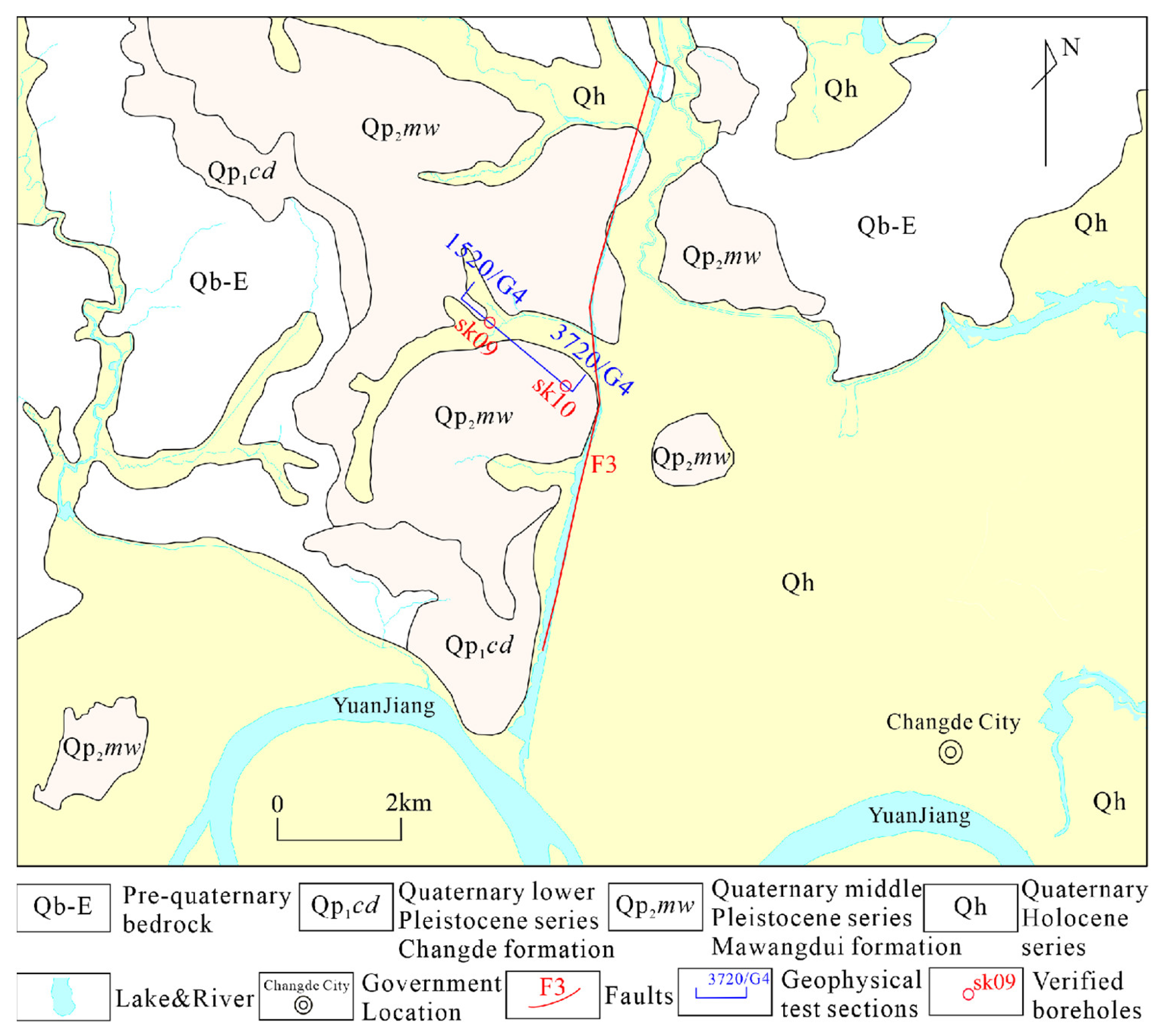
2. Geology
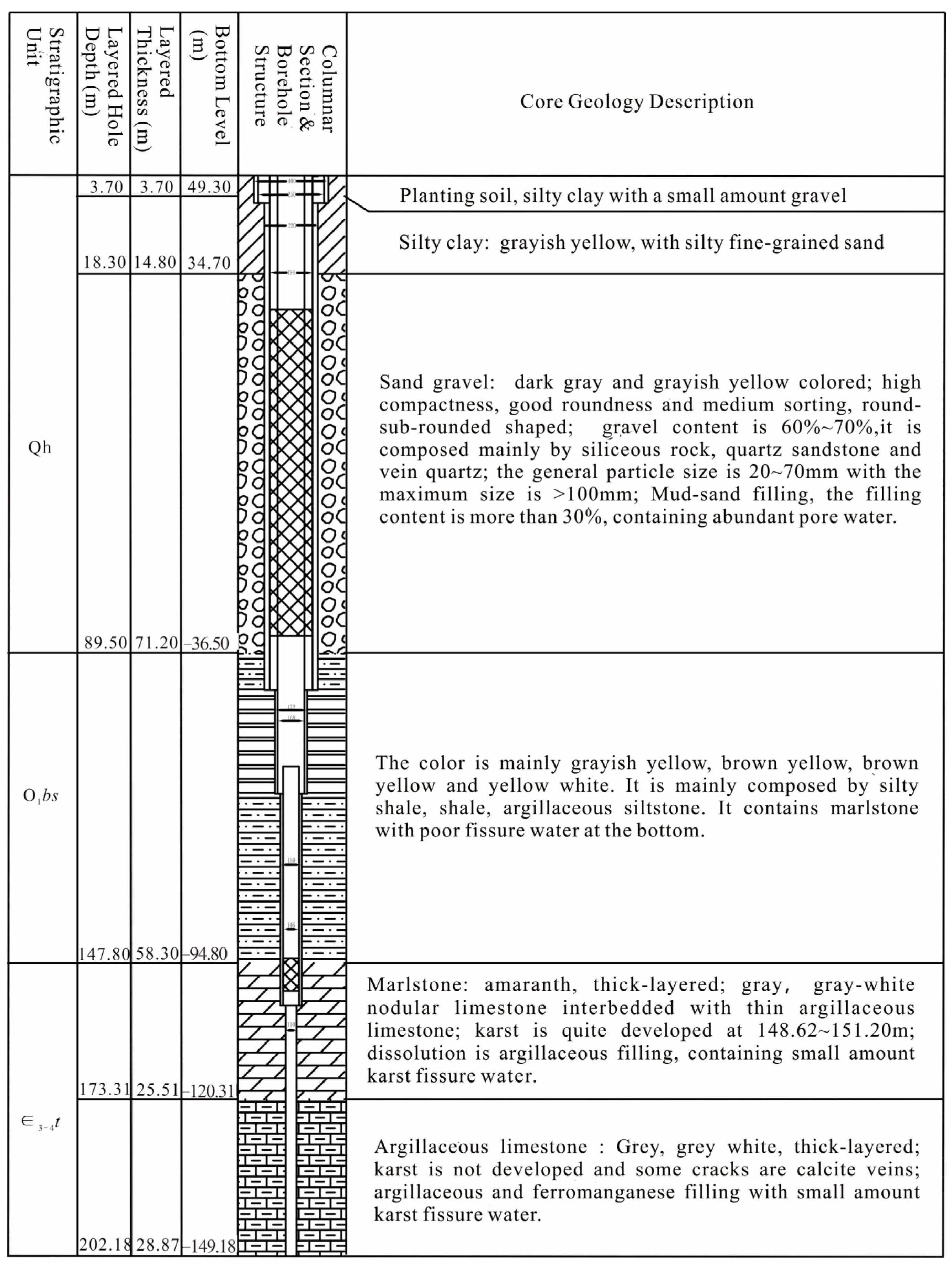
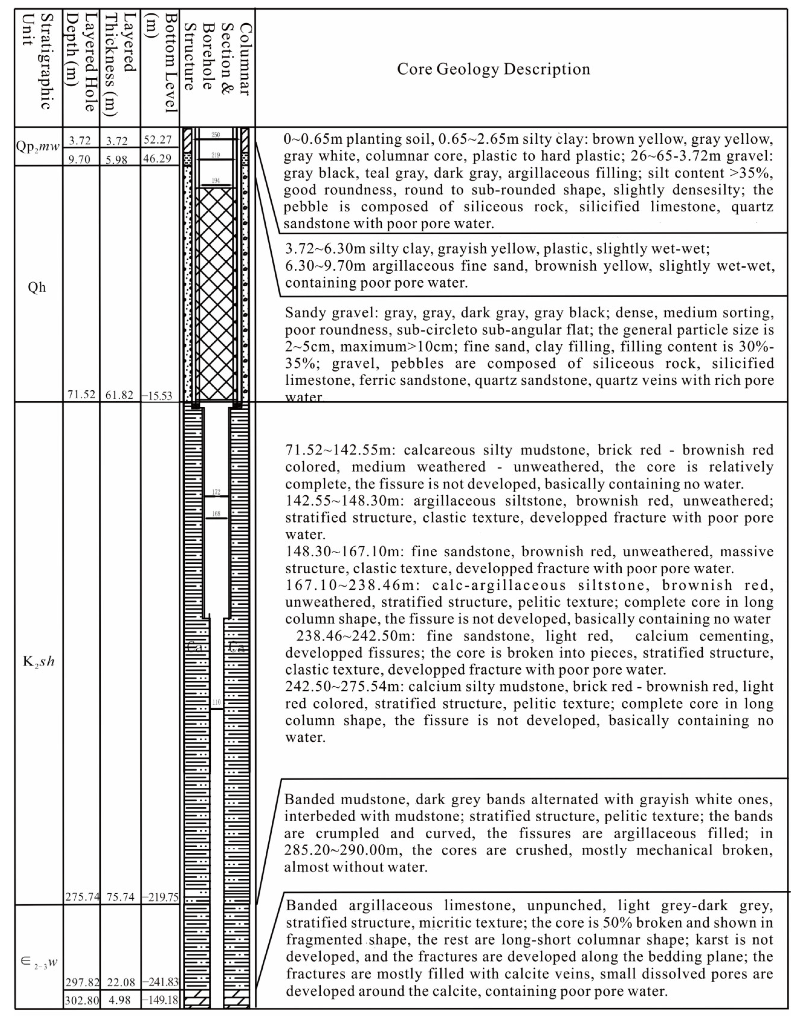
2.1. Stratum
2.2. Geologic Structure
3. Geophysical Techniques and Geophysical Characteristics
3.1. Geophysical Techniques
3.1.1. High-Density Resistivity Method
3.1.2. The Controlled-Source Audio-Magnetotelluric Method
3.1.3. Wide-Area Electromagnetic Method
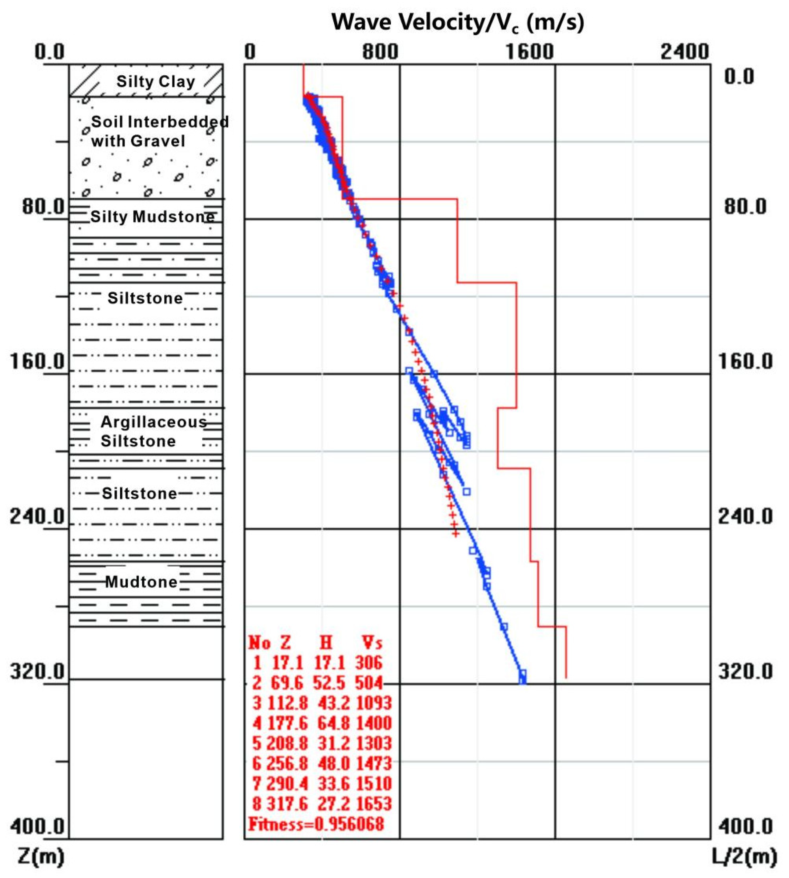
3.1.4. Natural Source Surface Wave Microtremor
3.2. Geophysical Characteristics of the Study Area
3.2.1. Regional Geophysical Characteristics of Changde City
3.2.2. Petrophysical Characteristics of the Study Area
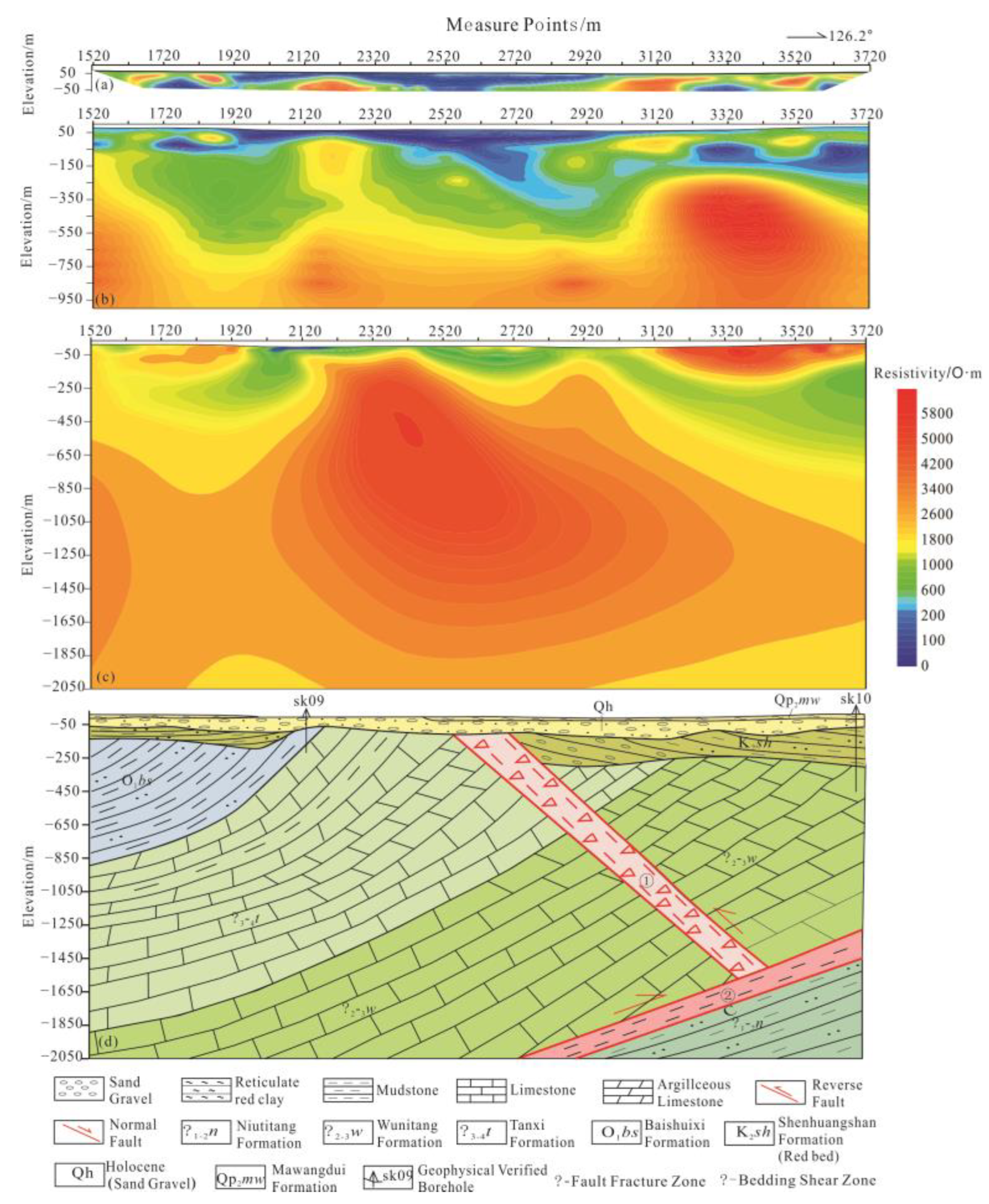
4. Results Interpretation and Drilling Verification
4.1. Results Interpretation
4.2. Drilling Verification
5. Conclusions
Author Contributions
Funding
Institutional Review Board Statement
Informed Consent Statement
Data Availability Statement
Conflicts of Interest
References
- Ministry of Natural Resources of the People’s Republic of China. Guiding Opinions on Strengthening Urban Geological Work. 2017. Available online: http://www.cgs.gov.cn/tzgg/tzgg/201709/t20170906_439047.html (accessed on 1 July 2017).
- Ministry of Natural Resources of the People’s Republic of China. Announcement of the Ministry of Natural Resources of the People’s Republic of China on the Release of Three Industry Standards, Including the “Specifications for Urban Geological Surveys”. 2017. Available online: http://finance.china.com.cn/roll/20170915/4393119.shtml (accessed on 1 July 2017).
- Cao, C.H. Proposal for the Science and Technology Research Project of Hunan Provincial Department of Land and Resources; Hunan Provincial Geological Survey: Changsha, China, 2017. [Google Scholar]
- Wu, Y.F.; Song, W.R.; Xu, H.G.; Liu, J.D. Application of shallow geophysical prospecting in monitoring urban geological hazards. Hazardology 1993, 8, 27–30. [Google Scholar]
- Li, X.B.; Cai, X.M.; Zhao, Y.; Wang, Z.H. Application of geophysical methods in urban geological survey. Urban Geol. 2008, 3, 31–36. [Google Scholar]
- Chen, X.F.; An, X.F. Seismic shear wave exploration and its application in shallow rock and soil layering. Prog. Geophys. 2007, 5, 1655–1659. [Google Scholar]
- Yang, Q.Y.; Peng, Y.Q.; Ni, M.; Gao, J.R.; Wen, S.L.; Zhang, R.Q.; Wu, Q.J.; Lu, G.J.; Wang, Y. Geophysical exploration methods and results of active faults in Shigatse City. Chin. J. Geophys. 2015, 58, 2137–2147. [Google Scholar]
- Han, S.H.; Zhang, S.T.; Guo, Y.F.; Mo, L.T. Application of multiple geophysical methods in the goaf survey. Nonferrous Met. Eng. 2017, 7, 76–81. [Google Scholar]
- Chen, S.; Li, Y.Q.; Li, T.H.; Zhang, J. Application of high-density electrical method in urban basic geological survey. Xinjiang Geol. 2019, 37, 28–33. [Google Scholar]
- Chen, S.; Li, Y.Q.; Li, T.H.; Jin, R.J.; Zhang, J. Application of Natural Source Surface Wave Technology in Urumqi Urban Geological Survey. Geophys. Geochem. Explor. 2019, 43, 1389–1398. [Google Scholar]
- Jiang, B.; Huang, J.J.; Jiang, G.Q.; Zhang, L.; Wu, X.; Xu, S.Y. Application of Geophysical Prospecting Technology in Xuzhou Urban Geological Survey. Urban Geol. 2019, 14, 101–108. [Google Scholar]
- Wang, Y.H.; Zhang, M.S.; Shi, Y.C.; Dong, Y.; Wang, F.; Yu, F.D. Exploration and Modeling of Urban Underground Space Based on Comprehensive Geophysical Prospecting. Northwestern Geol. 2019, 52, 83–94. [Google Scholar]
- Zhou, L.; Cao, C.H.; Deng, Z.; Tan, J.L.; Long, X. Geophysical Prospecting Water Finding Experiments in Limited Urban Sites. Urban Geol. 2019, 14, 97–102. [Google Scholar]
- Liu, G.Y.; Zhao, W.; Wei, F.H.; Luo, L.; Zhao, R.C.; Liang, E.Y. Analysis and sedimentary characteristics of the early Pleistocene gravel formations in the Nandoumu Lake area of Changde, Hunan. Chin. Geol. Surv. 2019, 6, 68–75. [Google Scholar]
- Zhao, Y.L.; Zhang, C.S.; Wang, Y.X.; Lin, H. Shear-related roughness classification and strength model of natural rock joint based on fuzzy comprehensive evaluation. Int. J. Rock Mech. Min. Sci. 2020, 137, 104550. [Google Scholar] [CrossRef]
- Zhao, Y.L.; Liu, Q.; Zhang, C.S.; Liao, J.; Lin, H.; Wang, Y.X. Coupled seepage-damage effect in fractured rock masses: Model development and a case study. Int. J. Rock Mech. Min. Sci. 2021, 144, 104822. [Google Scholar] [CrossRef]
- Liu, J.X.; Cao, C.H.; Guo, R.W.; Xie, G.F.; Liu, Y. Experimental research on high-density electrical sounding under different devices. Eng. Surv. 2013, 41, 85–89. [Google Scholar]
- Cao, C.H.; Deng, Z.; Liu, J.X. Discussion and Case Analysis of CSAMT Method Transceiver Distance in Changzhutan Area. J. Chin. Nonferrous Met. 2017, 27, 345–355. [Google Scholar]
- He, J.S. Combined Application of Wide-Field Electromagnetic Method and Flow Field Fitting Method for High-Resolution Exploration: A Case Study of the An-jia-ling No. 1 Coal Mine. Engineering 2018, 4, 188–205. [Google Scholar] [CrossRef]
- Liu, J.H.; Zhao, Y.L.; Tan, T.; Zhang, L.Y.; Zhu, S.T.; Xu, F.Y. Evolution and modeling of mine water inflow and hazards characteristics in southern coalfields of China: A case of Meitanba mine. Int. J. Min. Sci. Technol. 2022, 32, 513–524. [Google Scholar] [CrossRef]
- Zhao, Y.L.; Zhang, L.Y.; Liao, J.; Wang, W.J.; Liu, Q.; Tang, L.M. Experimental study of fracture toughness and subcritical crack growth of three rocks under different environments. Int. J. Geomech. 2020, 20, 4020128. [Google Scholar] [CrossRef]
- Zhao, Y.L.; Tang, J.Z.; Chen, Y.; Zhang, L.Y.; Wang, W.J.; Liao, J.P. Hydromechanical coupling tests for mechanical and permeability characteristics of fractured limestone in complete stress-strain process. Environ. Earth Sci. 2017, 76, 24. [Google Scholar] [CrossRef]
- Zhao, Y.L.; Luo, S.L.; Wang, Y.X.; Wang, W.J.; Zhang, L.Y.; Wan, W. Numerical analysis of karst water inrush and a criterion for establishing the width of water-resistant rock pillars. Mine Water Environ. 2017, 36, 508–519. [Google Scholar] [CrossRef]
- Liu, Y.; He, B.C.; Xie, J.; Lu, Y.L.; Zhang, L.Z. Compatibility of geosynthetic clay liners at different temperatures. J. Environ. Prot. Ecol. 2021, 22, 2295–2306. [Google Scholar]
- Zhan, Y.D.; Shao, Y.J.; Liu, Q.Q.; Zhang, X.; Chen, M.H.; Lu, Y.L.; Zhang, Y.C.; Tan, H.J. Hydrothermal rutile U-Pb dating of gold mineralization in the Jiangnan Orogen: A case study of the Hengjiangchong gold deposit in northeastern Hunan. Ore. Geol. Rev. 2022, 149, 105115. [Google Scholar] [CrossRef]
- Lu, Y.L.; Li, X.Q.; Liu, Y.; Leng, J.H. The establishment of ore-controlling fracture system of Baoginshan gold mine based on fracture-tectonic analysis. Mob. Inform. Syst. 2021, 2, 1–9. [Google Scholar] [CrossRef]


| Stratigraphic Code | Rock | Number | Average Resistivity/Rav (Ω·m) | Range/ (Ω·m) |
|---|---|---|---|---|
| Qb-E | pre-Quaternary bedrock | 32 | 998.3 | 212.3~5998.8 |
| Qp1cd | lower Pleistocene series Changde formation conglomerate | 22 | 223.1 | 128.3~889.5 |
| Qp2mw | middle Pleistocene series Mawangdui formation reticular clay | 33 | 23.1 | 100.5~2122.9 |
| Qh | Quaternary Holocene series gravel layer, silty clay | 27 | 298.3 | 12.5~588.7 |
| O1bs | Ordovician Baishuixi formation silty shale | 36 | 1000.3 | 621.9~1768.5 |
| ∈3-4t | Cambrian Tanxi formation dolomitic limestone | 31 | 2788.5 | 1189.3~5998.8 |
| ∈2-3w | Cambrian Wunidtang formation micritic argillaceous limestone | 33 | 1757.3 | 1121.1~2678.3 |
| ∈1-2n | Cambrian Niutitang formation Carbonaceous shale and mudstone | 35 | 798.2 | 339.1~1233.5 |
| Stratigraphic Code | Rock | Transverse Wave Velocity/Vtw (m·s−1) |
|---|---|---|
| Qb-E | pre-Quaternary bedrock | >800 |
| Qp1cd | lower Pleistocene series Changde formation conglomerate | 300~700 |
| Qp2mw | middle Pleistocene series Mawangdui formation reticular clay | <300 |
| Qh | Quaternary Holocene series gravel layer, silty clay | 300~800 |
| O1bs | Ordovician Baishuixi formation silty shale | 700~900 |
| ∈3-4t | Cambrian Tanxi formation dolomitic limestone | >1300 |
| ∈2-3w | Cambrian Wunidtang formation micritic argillaceous limestone | >1100 |
| ∈1-2n | Cambrian Niutitang formation Carbonaceous shale and mudstone | >900 |
Disclaimer/Publisher’s Note: The statements, opinions and data contained in all publications are solely those of the individual author(s) and contributor(s) and not of MDPI and/or the editor(s). MDPI and/or the editor(s) disclaim responsibility for any injury to people or property resulting from any ideas, methods, instructions or products referred to in the content. |
© 2022 by the authors. Licensee MDPI, Basel, Switzerland. This article is an open access article distributed under the terms and conditions of the Creative Commons Attribution (CC BY) license (https://creativecommons.org/licenses/by/4.0/).
Share and Cite
Lu, Y.-L.; Cao, C.-H.; Liu, Y.-Q.; Liu, Y. Study on Application of Comprehensive Geophysical Prospecting Method in Urban Geological Survey—Taking Concealed Bedrock Detection as an Example in Dingcheng District, Changde City, Hunan Province, China. Appl. Sci. 2023, 13, 417. https://doi.org/10.3390/app13010417
Lu Y-L, Cao C-H, Liu Y-Q, Liu Y. Study on Application of Comprehensive Geophysical Prospecting Method in Urban Geological Survey—Taking Concealed Bedrock Detection as an Example in Dingcheng District, Changde City, Hunan Province, China. Applied Sciences. 2023; 13(1):417. https://doi.org/10.3390/app13010417
Chicago/Turabian StyleLu, Yu-Long, Chuang-Hua Cao, Yao-Qi Liu, and Yang Liu. 2023. "Study on Application of Comprehensive Geophysical Prospecting Method in Urban Geological Survey—Taking Concealed Bedrock Detection as an Example in Dingcheng District, Changde City, Hunan Province, China" Applied Sciences 13, no. 1: 417. https://doi.org/10.3390/app13010417