

A Scalable Earth Observation Service to Map Land Cover in Geomorphological Complex Areas beyond the Dynamic World: An Application in Aosta Valley (NW Italy)


Abstract
:1. Introduction
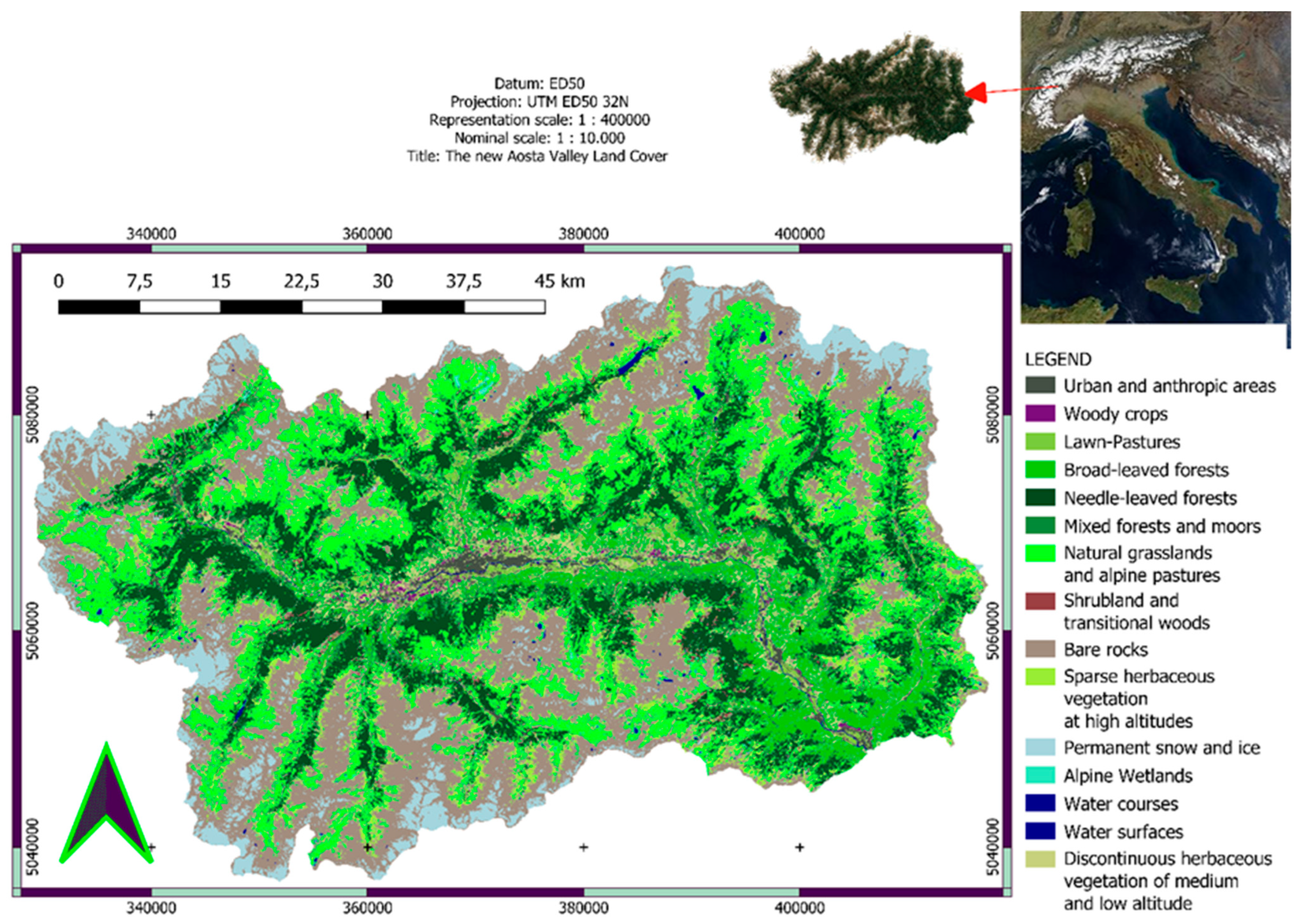
2. Study Area
3. Materials
- -
- Copernicus Sentinel-2A surface reflectance data to map the land cover components
- -
- Copernicus Sentinel-1A and B SLC and GRD data to map urban and water components, respectively
- -
- PlanetScope four band data to define a part of the training and validation set
- -
- GIS updated datasets such as GNSS ground truth data to define both the training set and the validation set.
3.1. Multispectral Optical Datasets
3.2. Sentinel-1 SAR Dataset
3.3. GIS Products and Ground Data
4. Methods
4.1. Sentinel-2
4.2. Sentinel-1
4.2.1. Water Mask
4.2.2. Land Cover Legend Definition
4.3. Training Set and Validation Set Definition
4.4. Supervised Classification Algorithms
4.5. Deep Learning Using the Convolutional Neural Network (CNN)
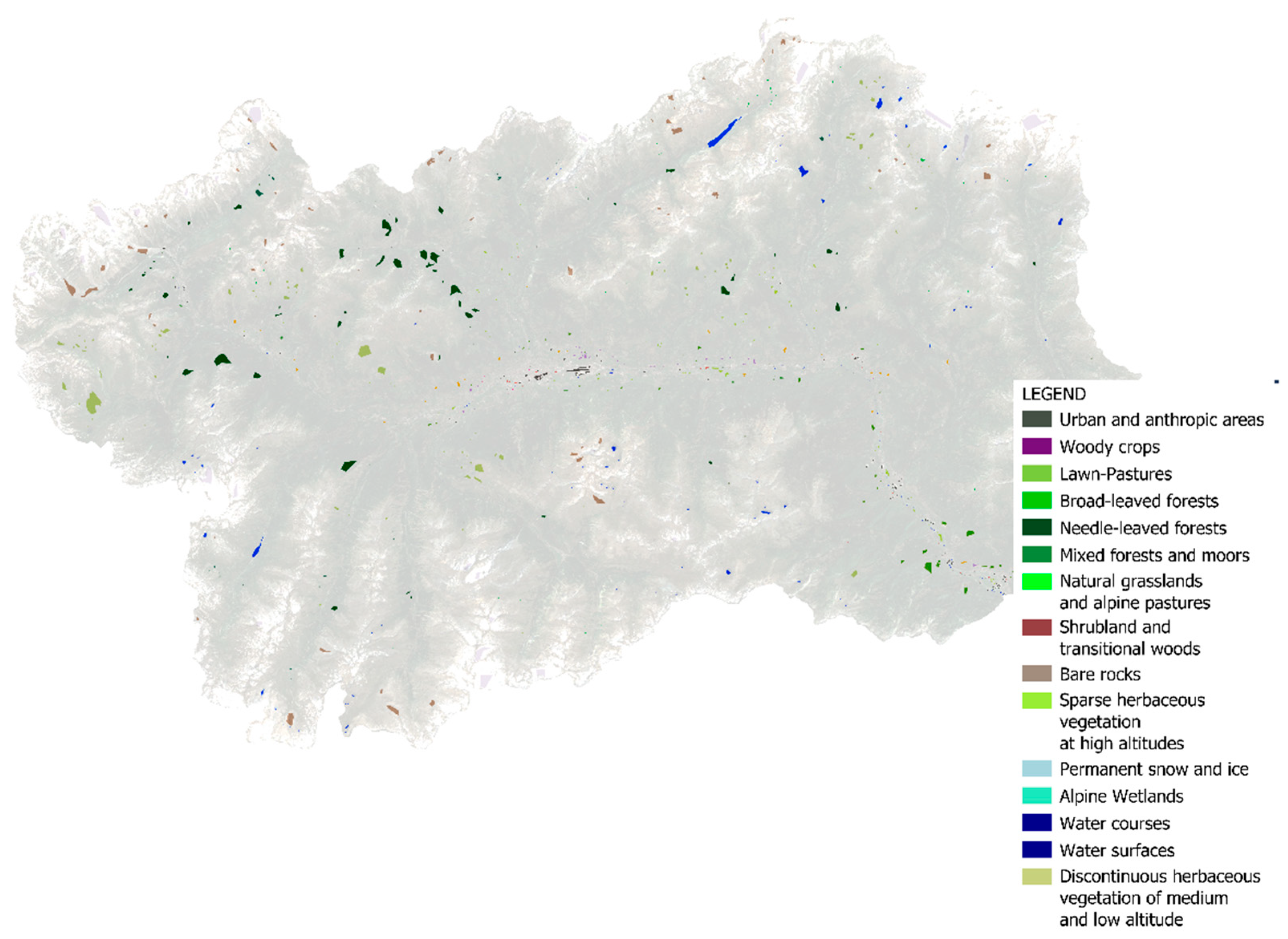
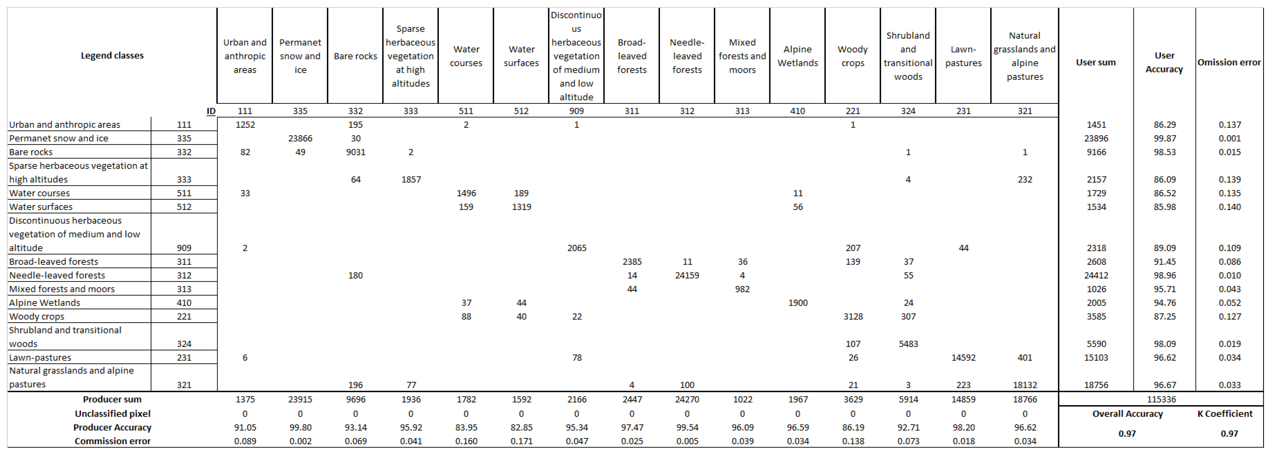
5. Results and Discussion
6. Conclusions
Author Contributions
Funding
Institutional Review Board Statement
Informed Consent Statement
Data Availability Statement
Acknowledgments
Conflicts of Interest
Appendix A
| RAVA Legend | EAGLE—ISPRA Legend | Description |
| Urban and anthropic areas (111) | Artificial abiotic surfaces | Surfaces strongly influenced by anthropic activity and characterized by human settlements. These are areas in which structures are built without distinction for the intended use or are under construction, as well as roads, airports, railways, parking lots and any artifact capable of determining a permanent or semi-permanent loss of the soil resource, including caves and mines. |
| Shrubland and transitional woods (324) | Shrubland | Natural or natural-shaped surfaces. Areas characterized by arboreal species and generally sparse woods near grazing areas or areas with reduced herbaceous vegetation and rocks (such as rubble). These areas indicate the dynamics of the ecological forest succession following the abandonment of grazing areas and consequent expansion of forest areas or following disturbances to natural or anthropogenic disturbances to the forest. |
| Woody crops (221) | Not defined (considered separately vineyards and orchards) | Surfaces characterized by the presence of various cultivation systems, in particular orchards and vineyards. Surfaces influenced by human activity and agronomic practices. |
| Water surfaces (512) | Water | Natural or natural-shaped surfaces. Areas characterized by the presence of bodies of water such as natural lakes of fluvial and/or glacial origin, artificial reservoirs and bodies of water in wetlands. |
| Water courses (511) | Water | Natural or natural-shaped surfaces. Areas characterized by the presence of watercourses such as rivers, streams along runoff lines and slope impluviums. |
| Needle-leaved forests (312) | Needle-leaved | Natural or natural-shaped surfaces. Wooded areas characterized by a prevalent and widespread presence of coniferous trees on a given surface (larch, spruce, fir, pine, Douglas fir, etc.) |
| Broad-leaved forests (311) | Broad-leaved forests | Natural or natural-shaped surfaces. Wooded areas characterized by a prevalent presence of broad-leaved trees on a given surface (oak, chestnut, ash, maple, linden, alder, birch, poplars, etc.) |
| Mixed forests and moors (313) | Not defined | Natural or natural-shaped surfaces. Wooded areas characterized by the presence of both broad-leaved and conifers with no evident prevalence and sometimes shrubs or the presence of heather (Erica spp. and Calluna vulgaris L.). |
| Permanent snow and ice (335) | Permanent snow and ice | Natural surfaces. Areas characterized by the presence of glaciers and glaciated surfaces such as seracs, icefalls and frozen or snow-covered surfaces such as snowfields in the considered observation period. It should be noted how the measurements carried out fall within the full ablation season and can, therefore, constitute a useful data on the perimeter in this sense. The rock glaciers entirely covered by debris and rocks are not included in this class, preferring to follow a criterion of spectral uniformity based on the typical characteristics of remote sensing with s1-s2 data in the context of the Copernicus Programme that are capable of investigating the surfaces, not the subsoil, as indicated in international scientific literature regarding both optical and sar remote sensing data of these missions. Therefore, we refer to the rock class. |
| Natural grasslands and alpine pastures (321) | Defined as generic pastures | Natural or natural-shaped surfaces. Areas characterized by natural evolution or by pastoral management conditioning practices. These areas are characterized by the presence of medium-high altitude herbaceous species. |
| Lawn pastures (231) | Defined as generic pastures | Natural-shaped surfaces. Areas characterized by herbaceous cover conditioned by pastoral and agronomic practices in this case mowing, haymaking and eventual irrigation. The areas can be characterized by both grazing and mowing. |
| Bare rocks (332) | Consolidated surfaces | Natural surfaces. Areas characterized by the presence of outcropping rocks and coherent non-vegetated soils. |
| Discontinuous herbaceous vegetation of medium-low altitude (909) | Not defined (only an unconsolidated class is present in a non-vegetated macro-class) | Natural or natural-shaped surfaces. Areas characterized by unconsolidated soils with continuous vegetation cover over time as they have reduced annual vegetation, xeric sparse vegetation or poorly managed grassing with little or no agronomic conditioning practices. This coverage also includes rock jumps provided with vegetation spots with occasional but not very powerful soils and extremely limited or absent vegetation. |
| Sparse herbaceous vegetation at high altitudes (333) | Herbaceous vegetation permanenet | Natural surfaces. Areas characterized by the presence of scarce but permanent vegetation that is difficult to graze given both the characteristics of the vegetation and, in some cases, the slope. These are high-altitude surfaces near rocks or natural grasslands and woods. |
| Alpine wetlands (410) | Defined as generic wetlands | Natural surfaces. Areas characterized by the presence of wetlands at different altitudes such as swamps, peat bogs and vegetation typical of these areas. Only the stretches of water in correspondence with these areas return to the water bodies. |
References
- Gorelick, N.; Hancher, M.; Dixon, M.; Ilyushchenko, S.; Thau, D.; Moore, R. Google Earth Engine: Planetary-Scale Geospatial Analysis for Everyone. Remote Sens. Environ. 2017, 202, 18–27. [Google Scholar] [CrossRef]
- Lukacz, P.M. Data Capitalism, Microsoft’s Planetary Computer, and the Biodiversity Informatics Community. In Proceedings of the International Conference on Information, Virtual Event, 28 February–4 March 2022; pp. 355–369. [Google Scholar]
- Mutanga, O.; Kumar, L. Google Earth Engine Applications. Remote Sens. 2019, 11, 591. [Google Scholar] [CrossRef] [Green Version]
- Highfill, T.C.; MacDonald, A.C. Estimating the United States Space Economy Using Input-Output Frameworks. Space Policy 2022, 60, 101474. [Google Scholar] [CrossRef]
- Miraux, L. Environmental Limits to the Space Sector’s Growth. Sci. Total Environ. 2022, 806, 150862. [Google Scholar] [CrossRef]
- Andreatta, D.; Gianelle, D.; Scotton, M.; Vescovo, L.; Dalponte, M. Detection of Grassland Mowing Frequency Using Time Series of Vegetation Indices from Sentinel-2 Imagery. GISci. Remote Sens. 2022, 59, 481–500. [Google Scholar] [CrossRef]
- Orusa, T.; Borgogno Mondino, E. Exploring Short-Term Climate Change Effects on Rangelands and Broad-Leaved Forests by Free Satellite Data in Aosta Valley (Northwest Italy). Climate 2021, 9, 47. [Google Scholar] [CrossRef]
- Orusa, T.; Orusa, R.; Viani, A.; Carella, E.; Borgogno Mondino, E. Geomatics and EO Data to Support Wildlife Diseases Assessment at Landscape Level: A Pilot Experience to Map Infectious Keratoconjunctivitis in Chamois and Phenological Trends in Aosta Valley (NW Italy). Remote Sens. 2020, 12, 3542. [Google Scholar] [CrossRef]
- Feranec, J.; Soukup, T.; Hazeu, G.; Jaffrain, G. European Landscape Dynamics: CORINE Land Cover Data; CRC Press: Boca Raton, FL, USA, 2016. [Google Scholar]
- Panagos, P.; Jones, A.; Van Liedekerke, M.; Orgiazzi, A.; Lugato, E.; Montanarella, L. JRC Support to the European Joint Programme for Soil (EJP SOIL); Technical Report by the Joint Research Centre (JRC), EUR 30450 EN, JRC122248; JRC: Ispra, Italy, 2020. [Google Scholar]
- Žlebir, S. Copernicus Earth Observation Programme. 40th COSPAR Sci. Assem. 2014, 40, A0–A1. [Google Scholar]
- De Fioravante, P.; Luti, T.; Cavalli, A.; Giuliani, C.; Dichicco, P.; Marchetti, M.; Chirici, G.; Congedo, L.; Munafò, M. Multispectral Sentinel-2 and SAR Sentinel-1 Integration for Automatic Land Cover Classification. Land 2021, 10, 611. [Google Scholar] [CrossRef]
- Anderson, K.; Ryan, B.; Sonntag, W.; Kavvada, A.; Friedl, L. Earth Observation in Service of the 2030 Agenda for Sustainable Development. Geo-Spat. Inf. Sci. 2017, 20, 77–96. [Google Scholar] [CrossRef]
- Wunder, S.; Kaphengst, T.; Frelih-Larsen, A. Implementing Land Degradation Neutrality (SDG 15.3) at National Level: General Approach, Indicator Selection and Experiences from Germany. In International Yearbook of Soil Law and Policy 2017; Springer: Berlin/Heidelberg, Germany, 2018; pp. 191–219. [Google Scholar]
- Arnold, S.; Kosztra, B.; Banko, G.; Milenov, P.; Smith, G.; Hazeu, G. Explanatory Content Documentation of the EAGLE Concept 2021; Version 3.1; EEA: Copenhagen, Denmark, 2021. [Google Scholar]
- Gómez, C.; White, J.C.; Wulder, M.A. Optical Remotely Sensed Time Series Data for Land Cover Classification: A Review. ISPRS J. Photogramm. Remote Sens. 2016, 116, 55–72. [Google Scholar] [CrossRef]
- Zhu, Z.; Gallant, A.L.; Woodcock, C.E.; Pengra, B.; Olofsson, P.; Loveland, T.R.; Jin, S.; Dahal, D.; Yang, L.; Auch, R.F. Optimizing Selection of Training and Auxiliary Data for Operational Land Cover Classification for the LCMAP Initiative. ISPRS J. Photogramm. Remote Sens. 2016, 122, 206–221. [Google Scholar] [CrossRef] [Green Version]
- Holloway, J.; Helmstedt, K.J.; Mengersen, K.; Schmidt, M. A Decision Tree Approach for Spatially Interpolating Missing Land Cover Data and Classifying Satellite Images. Remote Sens. 2019, 11, 1796. [Google Scholar] [CrossRef] [Green Version]
- Aune-Lundberg, L.; Strand, G.-H. The Content and Accuracy of the CORINE Land Cover Dataset for Norway. Int. J. Appl. Earth Obs. Geoinf. 2021, 96, 102266. [Google Scholar] [CrossRef]
- Waser, L.T.; Schwarz, M. Comparison of Large-Area Land Cover Products with National Forest Inventories and CORINE Land Cover in the European Alps. Int. J. Appl. Earth Obs. Geoinf. 2006, 8, 196–207. [Google Scholar] [CrossRef]
- De Fioravante, P.; Strollo, A.; Assennato, F.; Marinosci, I.; Congedo, L.; Munafò, M. High Resolution Land Cover Integrating Copernicus Products: A 2012–2020 Map of Italy. Land 2021, 11, 35. [Google Scholar] [CrossRef]
- Congedo, L.; Sallustio, L.; Munafò, M.; Ottaviano, M.; Tonti, D.; Marchetti, M. Copernicus High-Resolution Layers for Land Cover Classification in Italy. J. Maps 2016, 12, 1195–1205. [Google Scholar] [CrossRef] [Green Version]
- Karra, K.; Kontgis, C.; Statman-Weil, Z.; Mazzariello, J.C.; Mathis, M.; Brumby, S.P. Global Land Use/Land Cover with Sentinel 2 and Deep Learning. In Proceedings of the 2021 IEEE International Geoscience and Remote Sensing Symposium IGARSS, Brussels, Belgium, 11–16 July 2021; pp. 4704–4707. [Google Scholar]
- Comber, A.; Fisher, P.; Wadsworth, R. What Is Land Cover? Environ. Plan. B Plan. Des. 2005, 32, 199–209. [Google Scholar] [CrossRef] [Green Version]
- Comber, A.J.; Wadsworth, R.; Fisher, P. Using Semantics to Clarify the Conceptual Confusion between Land Cover and Land Use: The Example of “Forest”. J. Land Use Sci. 2008, 3, 185–198. [Google Scholar] [CrossRef] [Green Version]
- Vizzari, M. PlanetScope, Sentinel-2, and Sentinel-1 Data Integration for Object-Based Land Cover Classification in Google Earth Engine. Remote Sens. 2022, 14, 2628. [Google Scholar] [CrossRef]
- Velastegui-Montoya, A.; Rivera-Torres, H.; Herrera-Matamoros, V.; Sadeck, L.; Quevedo, R.P. Application of Google Earth Engine for Land Cover Classification in Yasuni National Park, Ecuador. In Proceedings of the IGARSS 2022—2022 IEEE International Geoscience and Remote Sensing Symposium, Kuala Lumpur, Malaysia, 17–22 July 2022; pp. 6376–6379. [Google Scholar]
- Huang, K.; Yang, G.; Yuan, Y.; Sun, W.; Meng, X.; Ge, Y. Optical and SAR Images Combined Mangrove Index Based on Multi-Feature Fusion. Sci. Remote Sens. 2022, 5, 100040. [Google Scholar] [CrossRef]
- Meng, X.; Liu, Q.; Shao, F.; Li, S. Spatio–Temporal–Spectral Collaborative Learning for Spatio–Temporal Fusion with Land Cover Changes. IEEE Trans. Geosci. Remote Sens. 2022, 60, 5704116. [Google Scholar] [CrossRef]
- Büttner, G.; Feranec, J.; Jaffrain, G.; Mari, L.; Maucha, G.; Soukup, T. The CORINE Land Cover 2000 Project. EARSeL eProceedings 2004, 3, 331–346. [Google Scholar]
- Büttner, G. CORINE Land Cover and Land Cover Change Products. In Land Use and Land Cover Mapping in Europe; Springer: Berlin/Heidelberg, Germany, 2014; pp. 55–74. [Google Scholar]
- Carella, E.; Orusa, T.; Viani, A.; Meloni, D.; Borgogno-Mondino, E.; Orusa, R. An Integrated, Tentative Remote-Sensing Approach Based on NDVI Entropy to Model Canine Distemper Virus in Wildlife and to Prompt Science-Based Management Policies. Animals 2022, 12, 1049. [Google Scholar] [CrossRef]
- Orusa, T.; Mondino, E.B. Landsat 8 Thermal Data to Support Urban Management and Planning in the Climate Change Era: A Case Study in Torino Area, NW Italy. In Proceedings of the Remote Sensing Technologies and Applications in Urban Environments IV, International Society for Optics and Photonics, Strasbourg, France, 9–10 September 2019; Volume 11157. [Google Scholar]
- Weiß, T.; Fincke, T. SenSARP: A Pipeline to Pre-Process Sentinel-1 SLC Data by Using ESA SNAP Sentinel-1 Toolbox. J. Open Source Softw. 2022, 7, 3337. [Google Scholar] [CrossRef]
- Amani, M.; Ghorbanian, A.; Ahmadi, S.A.; Kakooei, M.; Moghimi, A.; Mirmazloumi, S.M.; Moghaddam, S.H.A.; Mahdavi, S.; Ghahremanloo, M.; Parsian, S.; et al. Google Earth Engine Cloud Computing Platform for Remote Sensing Big Data Applications: A Comprehensive Review. IEEE J. Sel. Top. Appl. Earth Obs. Remote Sens. 2020, 13, 5326–5350. [Google Scholar] [CrossRef]
- Braun, A. Retrieval of Digital Elevation Models from Sentinel-1 Radar Data–Open Applications, Techniques, and Limitations. Open Geosci. 2021, 13, 532–569. [Google Scholar] [CrossRef]
- Richards, J.A. Remote Sensing with Imaging Radar; Springer: Berlin/Heidelberg, Germany, 2009; Volume 1. [Google Scholar]
- Samuele, D.P.; Filippo, S.; Orusa, T.; Enrico, B.-M. Mapping SAR Geometric Distortions and Their Stability along Time: A New Tool in Google Earth Engine Based on Sentinel-1 Image Time Series. Int. J. Remote Sens. 2021, 42, 9126–9145. [Google Scholar] [CrossRef]
- Grizonnet, M.; Michel, J.; Poughon, V.; Inglada, J.; Savinaud, M.; Cresson, R. Orfeo ToolBox: Open Source Processing of Remote Sensing Images. Open Geospat. Data Softw. Stand. 2017, 2, 15. [Google Scholar] [CrossRef] [Green Version]
- Inglada, J.; Christophe, E. The Orfeo Toolbox Remote Sensing Image Processing Software. In Proceedings of the 2009 IEEE International Geoscience and Remote Sensing Symposium, Cape Town, South Africa, 12–17 July 2009; Volume 4, p. IV-733. [Google Scholar]
- Conrad, O.; Bechtel, B.; Bock, M.; Dietrich, H.; Fischer, E.; Gerlitz, L.; Wehberg, J.; Wichmann, V.; Böhner, J. System for Automated Geoscientific Analyses (SAGA) v. 2.1. 4. Geosci. Model Dev. 2015, 8, 1991–2007. [Google Scholar] [CrossRef] [Green Version]
- QGIS Development Team. QGIS Development Team. QGIS Geographic Information System. In A Free and Open Source Geographic Information System; QGIS: Rome, Italy, 2018. [Google Scholar]
- Neteler, M.; Bowman, M.H.; Landa, M.; Metz, M. GRASS GIS: A Multi-Purpose Open Source GIS. Environ. Model. Softw. 2012, 31, 124–130. [Google Scholar] [CrossRef] [Green Version]
- Neteler, M.; Mitasova, H. Open Source GIS: A GRASS GIS Approach; Springer Science & Business Media: Cham, Switzerland, 2013; Volume 689. [Google Scholar]
- Deering, D.W. Rangeland Reflectance Characteristics Measured by Aircraft and Spacecraftsensors; Texas A&M University: College Station, TX, USA, 1978. [Google Scholar]
- Deering, D. Measuring” Forage Production” of Grazing Units from Landsat MSS Data. In Proceedings of the Tenth International Symposium of Remote Sensing of the Envrionment, Ann Arbor, MI, USA, 6–10 October 1975; pp. 1169–1198. [Google Scholar]
- Rouse, J., Jr.; Haas, R.H.; Deering, D.; Schell, J.; Harlan, J.C. Monitoring the Vernal Advancement and Retrogradation (Green Wave Effect) of Natural Vegetation; NASA: College Station, TX, USA, 1974. [Google Scholar]
- Rouse, J.; Haas, R.; Schell, J.; Deering, D. NASA SP-351. Monitoring vegetation systems in the Great Plains with ERTS. In Proceedings of the Third ERTS (Earth Resources Technology Satellite) Symposium, Washington, DC, USA, 10–14 December 1973; Volume 1, pp. 309–317. [Google Scholar]
- Tucker, C.J. Red and Photographic Infrared Linear Combinations for Monitoring Vegetation. Remote Sens. Environ. 1979, 8, 127–150. [Google Scholar] [CrossRef]
- Liu, H.; Zhan, Q.; Yang, C.; Wang, J. The Multi-Timescale Temporal Patterns and Dynamics of Land Surface Temperature Using Ensemble Empirical Mode Decomposition. Sci. Total Environ. 2019, 652, 243–255. [Google Scholar] [CrossRef] [PubMed]
- McFeeters, S.K. The Use of the Normalized Difference Water Index (NDWI) in the Delineation of Open Water Features. Int. J. Remote Sens. 1996, 17, 1425–1432. [Google Scholar] [CrossRef]
- Xu, H. Modification of Normalised Difference Water Index (NDWI) to Enhance Open Water Features in Remotely Sensed Imagery. Int. J. Remote Sens. 2006, 27, 3025–3033. [Google Scholar] [CrossRef]
- Valovcin, F. Snow/Cloud Discrimination; Air Force Geophysics Laboratory Rep; AFGL-TR-76-0174/ADA 032385; AFRL: Wright-Patterson Air Force Base, OH, USA, 1976. [Google Scholar]
- Valovcin, F.R. Spectral Radiance of Snow and Clouds in the near Infrared Spectral Region; AFRL: Wright-Patterson Air Force Base, OH, USA, 1978; Volume 78. [Google Scholar]
- Kyle, H.; Curran, R.; Barnes, W.; Escoe, D. A Cloud Physics Radiometer. In Proceedings of the 3rd Conference on Atmospheric Radiation, Berkeley, CA, USA, 28–30 June 1978; pp. 107–109. [Google Scholar]
- Bunting, J.T. Improved Cloud Detection Utilizing Defense Meteorological Satellite Program near Infrared Measurements; AFRL: Wright-Patterson Air Force Base, OH, USA, 1982. [Google Scholar]
- Jensen, J. Introductory Digital Image Processing—A Remote Sensing Perspective; New Jersey Prentice Hall: Englewood Cliffs, NJ, USA, 1986; 379p. [Google Scholar]
- Crist, E.P.; Cicone, R.C. Others Application of the Tasseled Cap Concept to Simulated Thematic Mapper Data. Photogramm. Eng. Remote Sens. 1984, 50, 343–352. [Google Scholar]
- Kauth, R.; Lambeck, P.; Richardson, W.; Thomas, G.; Pentland, A. Feature Extraction Applied to Agricultural Crops as Seen by Landsat. NASA. Johns. Space Cent. Proc. Tech. Sess. 1979, 1–2, 705–721. [Google Scholar]
- Huang, C.; Wylie, B.; Yang, L.; Homer, C.; Zylstra, G. Derivation of a Tasselled Cap Transformation Based on Landsat 7 At-Satellite Reflectance. Int. J. Remote Sens. 2002, 23, 1741–1748. [Google Scholar] [CrossRef]
- Kellndorfer, J.; Cartus, O.; Lavalle, M.; Magnard, C.; Milillo, P.; Oveisgharan, S.; Osmanoglu, B.; Rosen, P.A.; Wegmüller, U. Global Seasonal Sentinel-1 Interferometric Coherence and Backscatter Data Set. Sci. Data 2022, 9, 73. [Google Scholar] [CrossRef]
- Ohki, M.; Abe, T.; Tadono, T.; Shimada, M. Landslide Detection in Mountainous Forest Areas Using Polarimetry and Interferometric Coherence. Earth Planets Space 2020, 72, 67. [Google Scholar] [CrossRef]
- Sica, F.; Pulella, A.; Nannini, M.; Pinheiro, M.; Rizzoli, P. Repeat-Pass SAR Interferometry for Land Cover Classification: A Methodology Using Sentinel-1 Short-Time-Series. Remote Sens. Environ. 2019, 232, 111277. [Google Scholar] [CrossRef]
- Veci, L. Sentinel-1 Toolbox—TOPS Interferometry Tutorial; European Space Agency; Array Systems Computing Inc.: Toronto, ON, Canada, 2015. [Google Scholar]
- Veci, L.; Interferometry Tutorial. Array Systems. 2015. Available online: http://sentinel1.s3.amazonaws.com/docs/S1TBX%20Stripmap%20Interferometry%20with%20Sentinel-1%20Tutorial.pdf (accessed on 12 August 2017).
- Semenzato, A.; Pappalardo, S.E.; Codato, D.; Trivelloni, U.; De Zorzi, S.; Ferrari, S.; De Marchi, M.; Massironi, M. Mapping and Monitoring Urban Environment through Sentinel-1 SAR Data: A Case Study in the Veneto Region (Italy). ISPRS Int. J. Geo-Inf. 2020, 9, 375. [Google Scholar] [CrossRef]
- Filipponi, F. Sentinel-1 GRD Preprocessing Workflow. In Proceedings of the Multidisciplinary Digital Publishing Institute Proceedings, Online Event, 22 May–5 June 2019; Volume 18, p. 11. [Google Scholar]
- Knott, E.F.; Schaeffer, J.F.; Tulley, M.T. Radar Cross Section; SciTech Publishing: Sunnyvale, CA, USA, 2004. [Google Scholar]
- Zhang, W.; Hu, B.; Brown, G.S. Automatic Surface Water Mapping Using Polarimetric SAR Data for Long-Term Change Detection. Water 2020, 12, 872. [Google Scholar] [CrossRef] [Green Version]
- Davis, S.M.; Swain, P.H. Remote Sensing: The Quantitative Approach; McGraw-Hill International Book Company: New York, NY, USA, 1978. [Google Scholar]
- Hossain, M.D.; Chen, D. Segmentation for Object-Based Image Analysis (OBIA): A Review of Algorithms and Challenges from Remote Sensing Perspective. ISPRS J. Photogramm. Remote Sens. 2019, 150, 115–134. [Google Scholar]
- Stromann, O.; Nascetti, A.; Yousif, O.; Ban, Y. Dimensionality Reduction and Feature Selection for Object-Based Land Cover Classification Based on Sentinel-1 and Sentinel-2 Time Series Using Google Earth Engine. Remote Sens. 2020, 12, 76. [Google Scholar] [CrossRef]
- Press, W.H.; Teukolsky, S.A. Savitzky-Golay Smoothing Filters. Comput. Phys. 1990, 4, 669–672. [Google Scholar] [CrossRef]
- Chen, J.; Jönsson, P.; Tamura, M.; Gu, Z.; Matsushita, B.; Eklundh, L. A Simple Method for Reconstructing a High-Quality NDVI Time-Series Data Set Based on the Savitzky–Golay Filter. Remote Sens. Environ. 2004, 91, 332–344. [Google Scholar] [CrossRef]
- Schafer, R.W. What Is a Savitzky-Golay Filter? IEEE Signal Process. Mag. 2011, 28, 111–117. [Google Scholar] [CrossRef]
- Nguyen, M.D.; Baez-Villanueva, O.M.; Bui, D.D.; Nguyen, P.T.; Ribbe, L. Harmonization of Landsat and Sentinel 2 for Crop Monitoring in Drought Prone Areas: Case Studies of Ninh Thuan (Vietnam) and Bekaa (Lebanon). Remote Sens. 2020, 12, 281. [Google Scholar] [CrossRef] [Green Version]
- Barnes, E.; Clarke, T.; Richards, S.; Colaizzi, P.; Haberland, J.; Kostrzewski, M.; Waller, P.; Choi, C.; Riley, E.; Thompson, T.; et al. Coincident Detection of Crop Water Stress, Nitrogen Status and Canopy Density Using Ground Based Multispectral Data. In Proceedings of the Fifth International Conference on Precision Agriculture, Bloomington, MN, USA, 16–19 July 2000; Volume 1619. [Google Scholar]
- De Marinis, P.; De Petris, S.; Sarvia, F.; Manfron, G.; Momo, E.J.; Orusa, T.; Corvino, G.; Sali, G.; Borgogno, E.M. Supporting Pro-Poor Reforms of Agricultural Systems in Eastern DRC (Africa) with Remotely Sensed Data: A Possible Contribution of Spatial Entropy to Interpret Land Management Practices. Land 2021, 10, 1368. [Google Scholar] [CrossRef]
- Rocchini, D.; Marcantonio, M.; Ricotta, C. Measuring Rao’s Q Diversity Index from Remote Sensing: An Open Source Solution. Ecol. Indic. 2017, 72, 234–238. [Google Scholar] [CrossRef]
- Pavoine, S. Clarifying and Developing Analyses of Biodiversity: Towards a Generalisation of Current Approaches. Methods Ecol. Evol. 2012, 3, 509–518. [Google Scholar] [CrossRef]
- Borgogno-Mondino, E.; Farbo, A.; Novello, V.; Palma, L. de A Fast Regression-Based Approach to Map Water Status of Pomegranate Orchards with Sentinel 2 Data. Horticulturae 2022, 8, 759. [Google Scholar] [CrossRef]
- Foody, G.M. Status of Land Cover Classification Accuracy Assessment. Remote Sens. Environ. 2002, 80, 185–201. [Google Scholar] [CrossRef]


| Bands | Description | Spatial Resolution (m) |
|---|---|---|
| B1 | Aerosols | 60 |
| B2 | Blue | 10 |
| B3 | Green | 10 |
| B4 | Red | 10 |
| B5 | Red Edge 1 | 20 |
| B6 | Red Edge 2 | 20 |
| B7 | Red Edge 3 | 20 |
| B8 | NIR | 10 |
| B8A | Red Edge 4 | 20 |
| B9 | Water vapor | 60 |
| B11 | SWIR 1 | 20 |
| B12 | SWIR 2 | 20 |
| SCL | Mask | 10 |
| MSK_CLD_PRB | Cloud probability mask | 20 |
| QA10-60 | Cloud mask | 10–60 |
| Absolute Orbit Number | Polarization | Frame | Path | Flight Direction |
|---|---|---|---|---|
| 24,789 | VV+VH | 146 | 88 | ASCENDING |
| 24,417 | VV+VH | 441 | 66 | DESCENDING |
| ID | Bands/Index | Description |
|---|---|---|
| 1 | “B2” | Blue |
| 2 | “B3” | Green |
| 3 | “B4” | Red |
| 4 | “B5” | Vegetation Red Edge 1 |
| 5 | “B6” | Vegetation Red Edge 2 |
| 6 | “B7” | Vegetation Red Edge 3 |
| 7 | “B8” | NIR |
| 8 | “B8A” | Vegetation Red Edge 4 |
| 9 | “B11” | SWIR 1 |
| 10 | “B12” | SWIR 2 |
| 11 | “B2_STD” | Standard deviation Blue |
| 12 | “B3_STD” | Standard deviation Green |
| 13 | “B4_STD” | Standard deviation Red |
| 14 | “B5_STD” | Standard deviation Red Edge 1 |
| 15 | “B6_STD” | Standard deviation Red Edge 2 |
| 16 | “B7_STD” | Standard deviation Red Edge 3 |
| 17 | “B8_STD” | Standard deviation NIR |
| 18 | “B8A_STD” | Standard deviation Red Edge 4 |
| 19 | “B11_STD” | Standard deviation SWIR 1 |
| 20 | “B12_STD” | Standard deviation SWIR 2 |
| 21 | “NDVI” | Normalized Difference Vegetation Index |
| 22 | “NDVI_STD” | Standard deviation Normalized Difference Vegetation Index |
| 23 | “BSI” | Bare Soil Index |
| 24 | “BSI_STD” | Standard deviation Bare Soil Index |
| 25 | “NDWI” | Normalized Difference Water Index |
| 26 | “NDWI_STD” | Standard deviation Normalized Difference Water Index |
| 27 | “NDSI” | Normalized Difference Snow Index |
| 28 | “NDSI_STD” | Standard deviation Normalized Difference Snow Index |
| 29 | “TCB” | Tasseled Cap Brightness |
| 30 | “TCB_STD” | Standard deviation Tasseled Cap Brightness |
| 31 | “TCG” | Tasseled Cap Greenness |
| 32 | “TCG_STD” | Standard deviation Tasseled Cap Greenness |
| 33 | “TCW” | Tasseled Cap Wetness |
| 34 | “TCW_STD” | Standard deviation Tasseled Cap Wetness |
| 43 | DTM | Digital Terrain Model 10 m |
| 44 45 | Slope Aspect | Terrain Slope Terrain aspect |
| S1 Pairs Ascending Orbit (Product n°, Baseline, Temproal Distance in Days between the Two Acqusitions) | |||
|---|---|---|---|
| S1A_IW_SLC__1SDV_20200430T172327_20200430T172354_032360_03BEE8_2356 | S1B_IW_SLC__1SDV_20200506T172238_20200506T172305_021464_028C15_773E | 136 m | 5 |
| S1B_IW_SLC__1SDV_20200530T172240_20200530T172307_021814_029680_5539 | S1A_IW_SLC__1SDV_20200605T172329_20200605T172356_032885_03CF21_34AB | 152 m | 7 |
| S1A_IW_SLC__1SDV_20200804T172333_20200804T172400_033760_03E9BC_E6AD | S1B_IW_SLC__1SDV_20200810T172255_20200810T172322_022864_02B66E_1179 | 152 m | 6 |
| S1A_IW_SLC__1SDV_20200828T172334_20200828T172401_034110_03F5FE_8B79 | S1B_IW_SLC__1SDV_20200903T172253_20200903T172320_023214_02C15A_3F08 | 162 m | 6 |
| S1B_IW_SLC__1SDV_20200903T172253_20200903T172320_023214_02C15A_3F08 | S1A_IW_SLC__1SDV_20200909T172335_20200909T172402_034285_03FC20_A288 | 159 m | 6 |
| S1B_IW_SLC__1SDV_20201009T172254_20201009T172321_023739_02D1C8_57D8 | S1A_IW_SLC__1SDV_20201015T172336_20201015T172402_034810_040E9B_A403 | 134 m | 6 |
| S1B_IW_SLC__1SDV_20201114T172240_20201114T172307_024264_02E22F_E4D7 | S1A_IW_SLC__1SDV_20201120T172335_20201120T172402_035335_0420C3_E828 | 144 m | 7 |
| S1 Pairs Ascending orbit | |||
| S1A_IW_SLC__1SDV_20200112T053523_20200112T053550_030763_03871C_D73E | S1B_IW_SLC__1SDV_20200118T053455_20200118T053522_019867_02592E_ADC0 | 165 m | 5 |
| S1B_IW_SLC__1SDV_20200211T053455_20200211T053522_020217_026479_497E | S1A_IW_SLC__1SDV_20200217T053522_20200217T053548_031288_03996E_2722 | 155 m | 7 |
| S1A_IW_SLC__1SDV_20200324T053522_20200324T053549_031813_03ABB5_4955 | S1B_IW_SLC__1SDV_20200330T053455_20200330T053522_020917_027ABA_DC4C | 129 m | 5 |
| S1B_IW_SLC__1SDV_20200505T053456_20200505T053523_021442_028B5C_A52F | S1A_IW_SLC__1SDV_20200511T053523_20200511T053550_032513_03C3F4_2251 | 138 m | 7 |
| S1B_IW_SLC__1SDV_20200118T053455_20200118T053522_019867_02592E_ADC0 | S1A_IW_SLC__1SDV_20200124T053522_20200124T053549_030938_038D40_8123 | 147 m | 7 |
| S1 GRD | ||
|---|---|---|
| ID | Bands/Index | Description |
| 1 | “VV | Single co-polarization, vertical transmit/vertical receive |
| 2 | “VH” | Dual-band cross-polarization, vertical transmit/horizontal receive |
| 3 | “VV_STD” | Standard deviation single co-polarization, vertical transmit/vertical receive |
| 4 | “VH_STD” | Standard deviation dual-band cross-polarization, vertical transmit/horizontal receive |
| 5 | “NDPI” | Normalized Difference Polarization Index |
| 6 | “NDPI_STD” | Standard deviation Normalized Difference Polarization Index |
| 7 | “CR” | Cross ratio |
| 8 | “CR_STD” | Standard deviation cross ratio |
| Segmentation Parameter | Settings |
|---|---|
| Spatial radius | 3 pixels |
| Range radius | 100 DN |
| Mode convergence threshold | 0.1 |
| Maximum numerous of iterations | 200 |
| Minimum region size | 3 pixels |
| PARAMETERS | INPUT SETTINGS |
|---|---|
| Input Raster | Orthophoto.ecw |
| Output Detected Object | Buildings and Roads |
| Model Definition: | Edited models from ESRI .dplk |
| Padding: | 32 |
| Batch_size: | 16 |
| Threshold | 0.9 |
| Filtering threshold | 99.999 |
| Return_bboxes | False |
| Non-Maximum SuppressionOther parameters | CheckedDefault |
| ENVIRONMENTS | INPUT SETTINGS |
| Processing Extent | Raster extent |
| Processor Type GPU id Cell size Parallel processing | GPU Default Raster native GSD 8 |
| Approach | Overall Accuracy | K-Coefficient |
|---|---|---|
| Traditional approach | 88% | 0.88 |
| Combined approach | 89% | 0.89 |
| Mixed Hierarchical approach | 97% | 0.97 |
Disclaimer/Publisher’s Note: The statements, opinions and data contained in all publications are solely those of the individual author(s) and contributor(s) and not of MDPI and/or the editor(s). MDPI and/or the editor(s) disclaim responsibility for any injury to people or property resulting from any ideas, methods, instructions or products referred to in the content. |
© 2022 by the authors. Licensee MDPI, Basel, Switzerland. This article is an open access article distributed under the terms and conditions of the Creative Commons Attribution (CC BY) license (https://creativecommons.org/licenses/by/4.0/).
Share and Cite
Orusa, T.; Cammareri, D.; Borgogno Mondino, E. A Scalable Earth Observation Service to Map Land Cover in Geomorphological Complex Areas beyond the Dynamic World: An Application in Aosta Valley (NW Italy). Appl. Sci. 2023, 13, 390. https://doi.org/10.3390/app13010390
Orusa T, Cammareri D, Borgogno Mondino E. A Scalable Earth Observation Service to Map Land Cover in Geomorphological Complex Areas beyond the Dynamic World: An Application in Aosta Valley (NW Italy). Applied Sciences. 2023; 13(1):390. https://doi.org/10.3390/app13010390
Chicago/Turabian StyleOrusa, Tommaso, Duke Cammareri, and Enrico Borgogno Mondino. 2023. "A Scalable Earth Observation Service to Map Land Cover in Geomorphological Complex Areas beyond the Dynamic World: An Application in Aosta Valley (NW Italy)" Applied Sciences 13, no. 1: 390. https://doi.org/10.3390/app13010390