
Land Suitability Mapping Using Geochemical and Spatial Analysis Methods
by
 , ,
, ,
Dimitrios E. Alexakis
1 ,
,
George D. Bathrellos
2,* ,
,
Hariklia D. Skilodimou
3 and 
Dimitra E. Gamvroula
1 1
Laboratory of Geoenvironmental Science and Environmental Quality Assurance, Department of Civil Engineering, School of Engineering, University of West Attica, 250 Thivon & P. Ralli Str., 12241 Athens, Greece
2
Division of General Marine Geology and Geodynamics, Department of Geology, University of Patras, 26504 Rio Patras, Greece
3
Department of Geography and Climatology, Faculty of Geology and Geoenvironment, University Campus, National and Kapodistrian University of Athens, Zografos, 15784 Athens, Greece
*
Author to whom correspondence should be addressed.
Appl. Sci. 2021, 11(12), 5404; https://doi.org/10.3390/app11125404
Submission received: 21 May 2021
/
Revised: 3 June 2021
/
Accepted: 8 June 2021
/
Published: 10 June 2021
(This article belongs to the Special Issue Geography of Soil Contamination for Polluted Sites Characterization and Precision Remediation)
Abstract
:Assessing the suitability of urban and agricultural land is essential for planning sustainable urban and agricultural systems. The main objective of this study is to evaluate the suitability of land in Ioannina plain (western Greece) concerning the soil contents of two potentially toxic elements, cadmium (Cd) and cobalt (Co). Geochemical and spatial analysis methods were applied to assess the distribution of Cd and Co in the soil of the Ioannina plain and identify their origin. The primary anthropogenic sources of Cd and Co in the topsoil of the study area can be attributed to traffic emissions, aircraft operations, vehicle crushing and dismantling activities. Element content is compared to international guidelines and screening values. Cadmium and Co concentration in the soil of the study area is well above the European topsoil mean. Thus, the urban and agricultural lands cover the vast majority (92%) of the total area. Cadmium concentration in soil of the study area with a mean (mg kg−1) 1.7 and 2.0 was observed in agricultural and urban land use, respectively. Cobalt content in soil of the area studied with a mean (mg kg−1) 30.8 and 37.1 was recorded in agricultural and urban land use, respectively. Land evaluation suitability by adopting criteria provided from the international literature is discussed.
1. Introduction
Land contaminated with trace elements is a common issue in many parts of the world, which can influence human health and ecosystems [1,2,3,4]. Mapping trace element content in urban and agricultural soils revealed contaminated areas in many regions [3,4,5]. In the last decades, geographical information systems (GIS) have become an outstanding and helpful tools for mapping trace element content in various environmental materials and for analyzing spatial data [6,7,8,9,10]. Moreover, GIS have become integral tools to address natural hazard phenomena [11,12,13,14,15,16,17,18,19], as well as to estimate suitable sites for land use planning [20,21,22,23,24,25]. These current geospatial technologies are beneficial to demonstrate soil properties [26], environmental parameters and spatial visualization of chemical compounds [27,28,29,30,31]. Therefore, GIS are essential tools in the spatial analysis of element distribution.
Geochemical surveys are performed for the identification and delineation of a geochemical anomaly that would aid in locating an element contamination source. Geochemical and spatial analysis methods evidencing relationships of element distribution were instrumental in confirming element geochemical interpretation [27,28,32]. Many researchers reported a high concentration of toxic elements in water, soil and sediment [27,32,33,34,35,36,37,38,39,40].
Land suitability evaluation is essential for planning a sustainable agricultural system [41,42,43]. Evaluation of land suitability aims to identify the limiting factors for specific land use. Land use requirements are described, among others, by the absence of a toxic level of elements in the soil. Many plants, vegetables and fruit trees can absorb Cd and Co as they are grown in contaminated soil [44,45,46]. Consuming plants, vegetables or fruits grown in contaminated soil may pose a risk for human health.
Moreover, Cd and Co are just as toxic to plants as they are to humans and animals [44]. On the other hand, many plants can accumulate Cd and Co and consequently can be used for phytoremediation to extract and detoxify these elements from soil [47]. In this study, information about potentially toxic element content is considered for land suitability in the Ioannina basin. More specifically, the approach of land suitability assessment applied in this study is based on the soil contamination with Cd and Co. Various types of anthropogenic activities are recorded in the Ioannina basin, while their impact on soil and water resources is not evaluated until now. Moreover, distribution and delivery of weathering material enriched in potentially toxic elements from the Ioannina basin to receiving Pamvotis lake may severely affect the lake water and sediments.
The aims of this study were: (a) to record the cadmium (Cd) and cobalt (Co) concentration in soil of the Ioannina basin; and (b) to assess the land suitability for residential and agricultural use.
2. Study Area
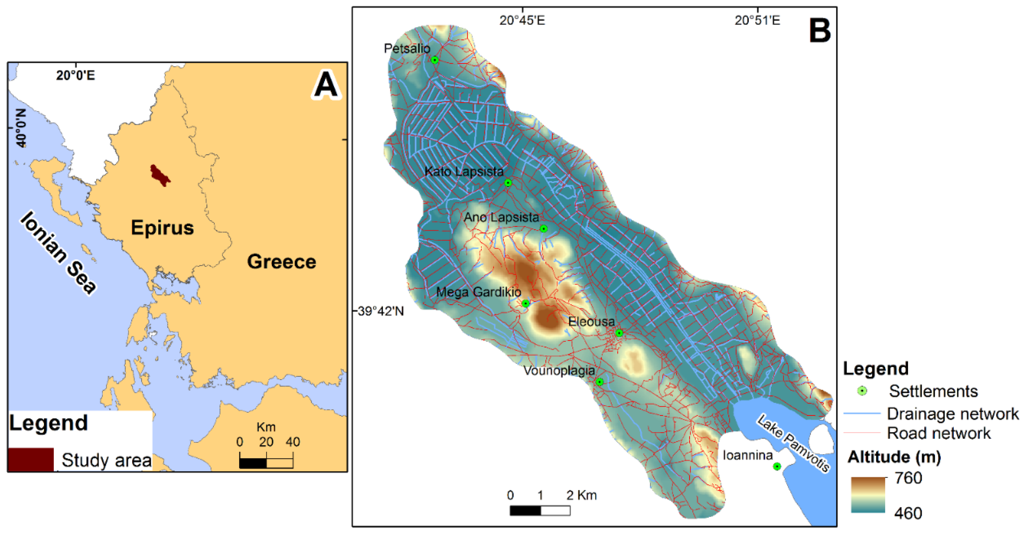
The area studied is located in the administrative region of Epirus in western Greece and is a part of the Ioannina basin (Figure 1A). A part of the Ioannina city is situated within the limits of the study area. The city is the largest city of Epirus and the eighth-largest city in Greece. The study area hosts several human activities such as agriculture and tourism. According to Papadopoulou-Vrynioti et al. [48], the Ioannina basin is a karst landscape that is characterized as polje. This type of surface karst feature is an elongated depression, including a flat floor. Thus, the study area has a smooth relief with gentle slopes. Its morphology comprises a lowland area with an altitude of 460 m a.s.l. and a hilly area reaching an elevation of 760 m a.s.l. (Figure 1B). It covers an area of 101 km2 and is drained by an artificial network.
The mean annual precipitation reaches about 1090 mm, and the rainiest month is December (171.3 mm mean annual rainfall). The mean annual temperature is 14.3 °C. The warmest month is July, with a mean monthly temperature of 25 °C and the coldest the January (4.7 °C mean monthly temperature). Regarding the wind, the dominant wind direction is the west (W). The annual frequency of westerly winds reaches up to 7% [49].
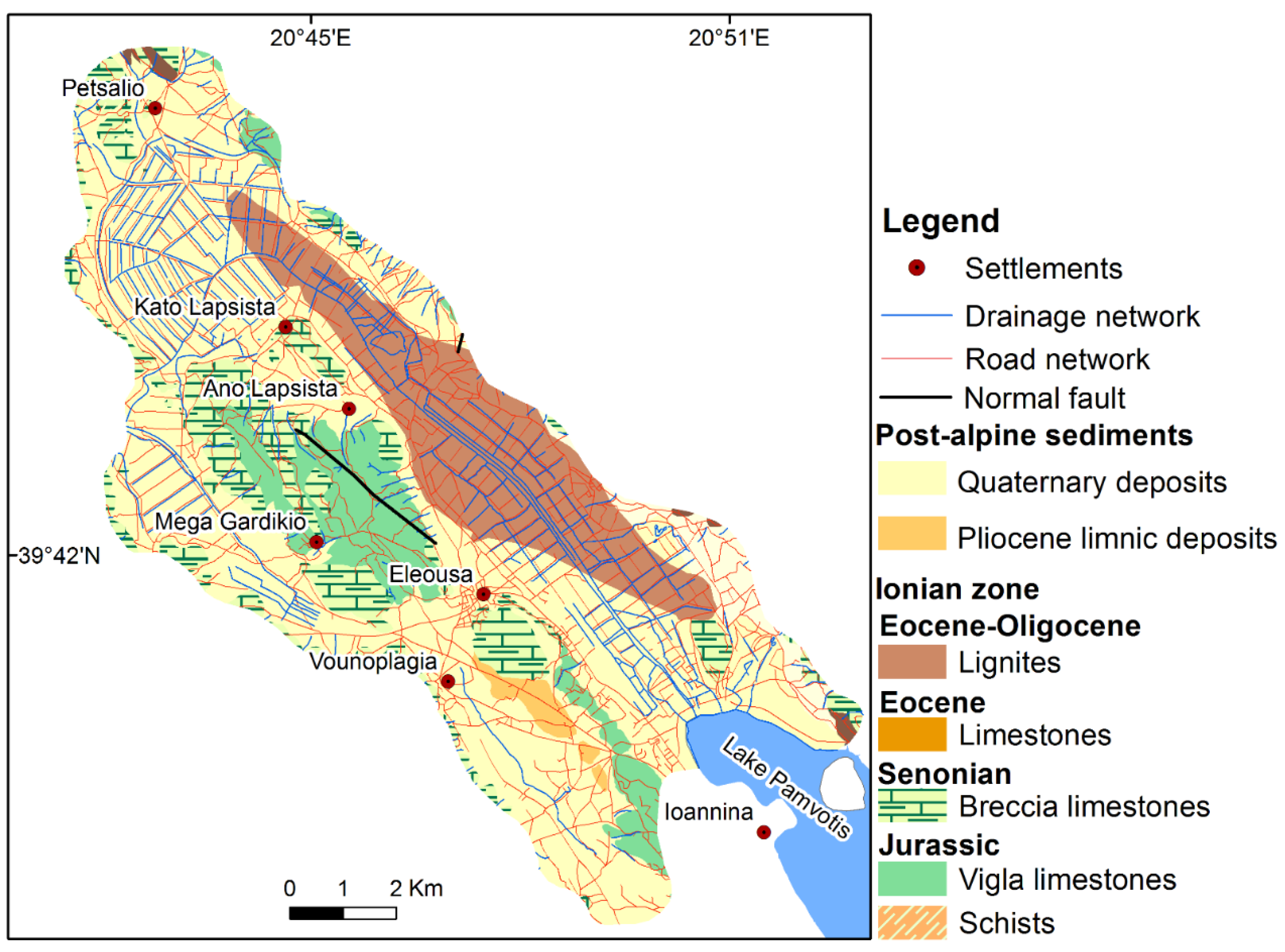
Figure 2 illustrates the geological formation of the study area. It is comprised of the Ionian geotectonic zone and post-alpine sediments formation [50]. The alpine formations consist of Jurassic schists; (b) Upper-Jurassic Vigla limestones; (c) Senonian micro-breccia limestones; (d) Eocene limestones [51,52]; and (e) Eocene to Oligocene lignites [53]. The post-alpine sediments include Pliocene limnic sediments and Quaternary deposits [54]. The Quaternary deposits cover a significant part of the area studied (Figure 2). Their composition includes fragments of flint, terra-rossa and Fe-Mn oxides [48,55]. The following soil types are observed in the land uses of the study area [56]: (a) Calcari-lithic Leptosol (Ic), which are found in areas where the soil has been eroded to the extent that hard rock comes near to the surface; (b) Chromic Luvisol (Lc), which generally occur on well-drained landscapes and are fertile soils suitable for a wide range of cultivated crop plants; and (c) Calcaric Fluvisol (Jc), which are found in periodically flooded areas.
3. Materials and Methods
3.1. Data
The data collected for this study include (a) a topographic map at a scale of 1:50,000, published by the Hellenic Army Geographical Service (H.A.G.S.); (b) a geological map at a scale of 1:50,000 (sheet Ioannina), published by the Institute of Geology and Mineral Exploration-IGME [50]; (c) information derived from the European Soil Atlas [56]; (d) the CORINE/Land cover from the Copernicus program [57]; and (e) a soil geochemical database derived by Vryniotis [55].
3.2. Data Processing and Spatial Analysis
In the present study, data were inserted in a GIS environment, and a spatial database was created for processing, analyzing and presenting spatial information. The software code ArcGIS was used for the spatial analysis of the area studied. The geological formations and the land uses were added to the database as polygon layers. The land uses were categorized into different classes according to their characteristics. Additionally, the Cd and Co contents in soil were visualized as a graduated symbol. Further, they were grouped using the natural breaks classification method into three categories. The numerical values of Cd and Co were interpolated using the inverse distance weighted (IDW) method. This spatial interpolation method has been used in several works for mapping of natural hazards [17,18], land-use suitability [21,22,23,25] and soil properties [26,28,29], indicating reliable results and high accuracy of the produced map. The produced maps demonstrated the spatial distribution of Cd and Co with continuous numerical values. Values were grouped into three classes according to the guidelines provided from the literature. Finally, they were correlated with the spatial distribution of each land use to estimate the suitability of the land uses.
3.3. Land Use
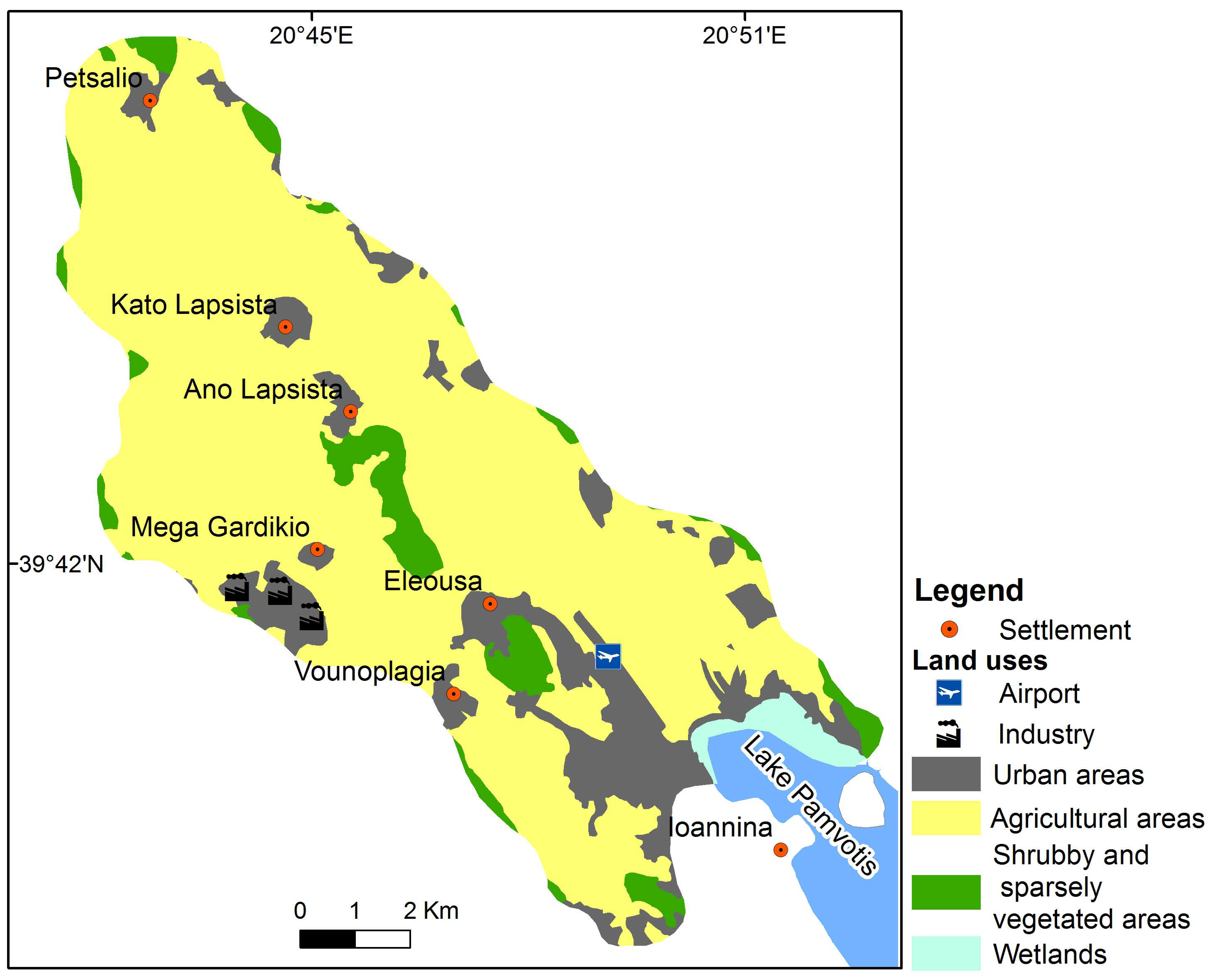
Under the CORINE 2012 Land Cover (CLC) Copernicus classification system [48], land use within the Ioannina plain is reported as the urban fabric of residential areas along with main roads and a mixture of agricultural, light industry, wetlands, shrub and sparsely vegetation areas (Figure 3). The establishments of the Ioannina city’s airport are located in the southern part of the area studied. The main industrial area is situated on the Ioannina plain’s western edge and includes vehicle crushing and car dismantling activities (Figure 3).
3.4. Soil Sampling and Laboratory Procedures
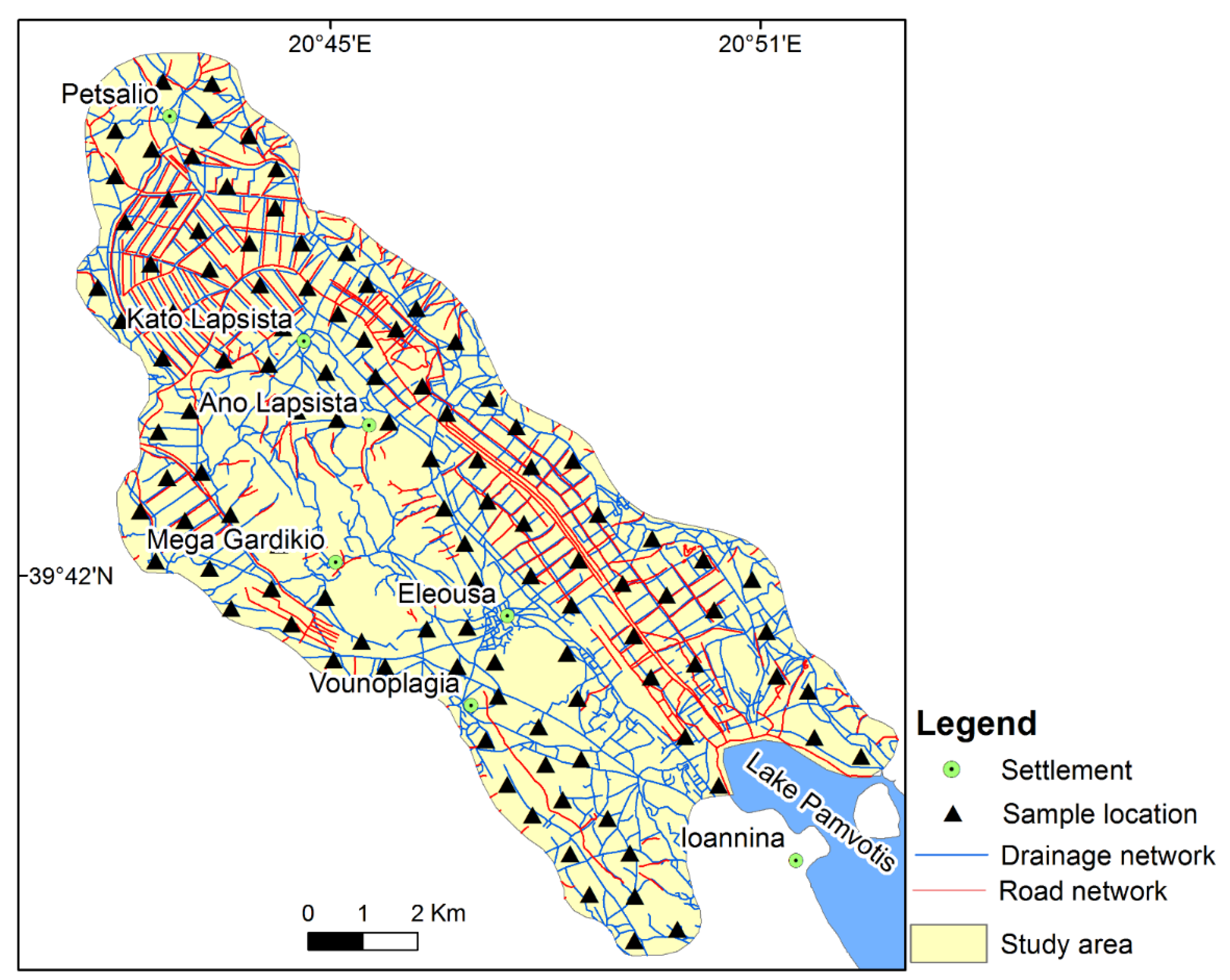
Topsoil samples (0–30 cm depth) were gathered from 112 sites from the Ioannina basin (Figure 4). A sample grid map covered the study area with equal distant spacing between the intersection points. The distance between the intersection areas is related to the size of the grid cell. The spacing distances as short as 1 km have been used in this study. At each sampling site, its surface was cleared of vegetation and debris, and a bulk soil sample was collected using a plastic spade to avoid metal contamination, following the soil sampling procedure of Papadopoulou-Vrynioti et al. [26]. Each 2 kg bulk soil sample comprises four 0.5 kg subsamples taken from a square frame (2 m × 2 m).
Preparation and chemical analysis of soil samples was performed using the procedures to soil treatment of Papadopoulou-Vrynioti et al. [26]. The soil samples were digested with an aliquot of the aqua-regia acid solution (HCl:HNO3, 3:1 v/v). The supernatants were used for the measurement of Cd and Co by atomic absorption spectroscopy (AAS) under the following conditions: (a) for Cd: wavelength 228.8 nm and lamp current 8 mA; and (b) for Co: wavelength 240.7 nm and lamp current 10 mA.
Certified Cd and Co atomic absorption standards (1 mg/mL) were obtained from Fisher Scientific Co. For this study, intermediate working standard solutions, generally at concentrations of 1–5 μg/mL, were produced by diluting the 1 mg/mL standard solution with ultrapure water. Working standards were produced daily from the intermediate standard. Analytical quality was monitored using reference samples, in-house reference materials and method blanks.
3.5. Land Evaluation Suitability
Cadmium and Co concentrations in the soil of the study area were compared against corresponding median values for European topsoil given by the Forum of European Geological Surveys (FOREGS) [58]. Land evaluation suitability in the study area was performed by adopting guidelines for soil concentration of Cd and Co established by Environmental Protection Agency (EPA) [59], Canadian Council of Ministers of the Environment (CCME) [60] and Department of Environment and Conservation (DEC) [61] (Table 1). Soil quality criteria for agricultural land use are applied uniformly for different soil types and crops, not fully considering the effects of soil properties on Cd and Co uptake via soil-plant transfer [62].
4. Results and Discussion
4.1. Land Uses
The area of each land use and its percentage proportion in the study area was estimated and illustrated in Table 2. As shown in Table 2, agricultural land use covers a significant part of the area studied. Human activities have strongly influenced the land uses of the study area. Thus, the urban and agricultural uses cover up to 92% of the total area.
The smooth morphology supports urban development in the study area. The Ioannina city’s airport is a mid-sized airport with an annual mean of 2219 flights; during 1994–2016, there were 48,732 flights [49].
4.2. Element Content in the Soil of Study Area and Source Apportionment
4.2.1. Cadmium
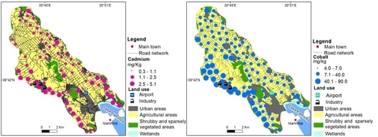
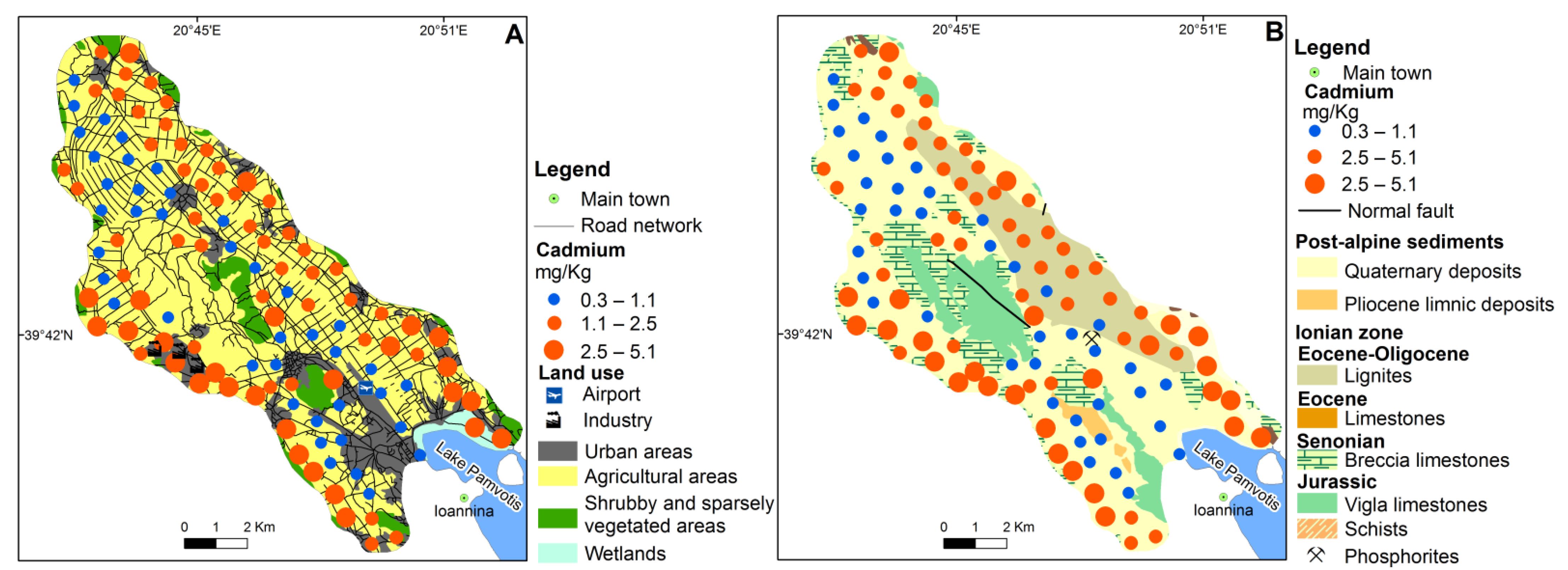
All soil samples in the Ioannina plain contained Cd content well above European topsoil’s median value [58] (Table 1). The geochemical spatial distribution map of Cd included in the Geochemical Atlas of Europe [58] indicated Cd content in the soil of the study area varying between 0.37 and 0.83 mg kg−1, while this study revealed that Cd range for soil is 0.3–5.1 mg kg−1 (Table 1). Cadmium content in soil ranging from 2.5 to 5.1 mg kg−1 is observed at sampling sites located parallel to the Ioannina plain’s north-eastern edge, especially in the proximity of the airport of Ioannina city (Figure 5A,B). According to Vryniotis [55], the phosphorite rocks can be considered as a lithological source of Cd in the soil of the Ioannina basin. The spatial distribution of Cd concentration in soil at the Ioannina basin does not demonstrate a significant association of Cd contents with a geological formation outcropping in the area studied (Figure 5B).
Many researchers [31,63] have studied Cd contents in the vicinity of roadways and reported a direct link between Cd and traffic emissions, supporting the suggestion that vehicles are an additional Cd contamination source for topsoil of the study area. Moreover, Cd is mainly found in automobile paints and is employed extensively in automobile radiator fine stock and batteries [64], suggesting that vehicle crushing and dismantling activities occurring at the eastern part of the study area promotes the emission of Cd. Furthermore, Jaradat et al. [64] recorded significant differences between Cd content in plants collected inside (0.612 mg kg−1) and outside (0.484 mg kg−1) a scrapyard of discarded vehicles at Zarqa city (Jordan). The primary anthropogenic sources of Cd in sampling locations parallel to the north-eastern edge of the Ioannina plain (Figure 5A,B) can be attributed to (a) automobile emissions; (b) airborne contamination related to airport activities; and (c) emissions from vehicle crushing and dismantling industry (e.g., shredder residues particles, batteries).
According to Agrawal et al. [65], the Cd emissions related to aircraft engines’ function is up to 0,0146 mg Cd per 1 kg of combusted fuel. Atmospheric deposition of Cd in the soil in many airports as an environmental impact related to air-traffic activities is also reported by Nunes et al. [66]. In the western edge of the Ioannina basin, Cd concentration in soil ranges from 1.1 to 5.1 mg kg−1 (Figure 5A,B), which is mainly attributed to (a) vehicle emissions and (b) emissions related to airport traffic.
4.2.2. Cobalt
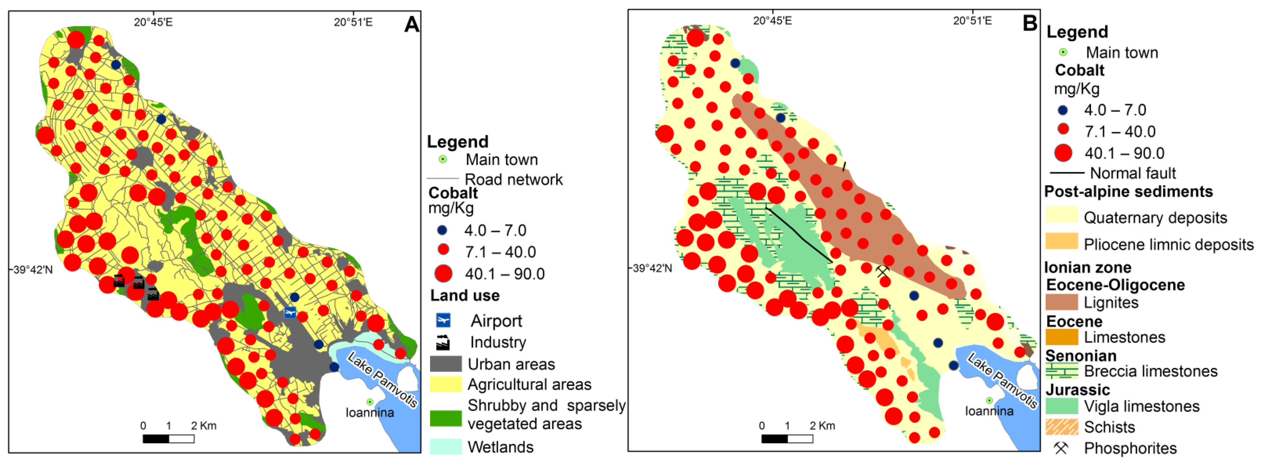
The majority of soil sampling sites (95.5%) in the Ioannina plain contained Cd concentration higher than the median value of European soil [58]. The geochemical spatial distribution map of Co incorporated in the Geochemical Atlas of Europe [58] illustrated Co content in the soil of the Ioannina basin varying between 16 and 25 mg kg−1, while this study revealed Co concentration in soil ranging from 4.0 to 90.0 mg kg−1 (Table 1). Cobalt content in the soil of the area studied shows similar spatial distribution to Cd, suggesting a common origin or similar dispersion mechanism (Figure 6A,B). Vryniotis [55] reported that Fe-Mn oxides within Quaternary deposits could be considered as a geological source of Co in the soil of the study area. However, Co concentration in soil has no spatial association with a lithological formation in the study area (Figure 6B). Many studies [31,67] recorded an increase in Co content in roadside soil of other cities attributed to the traffic inputs, especially the aircraft engine wear. Abegglen et al. [68] reported that Co is detected in the debris derived from high-pressure turbines due to aircraft engine wear, the so-called honeycomb structures built into the compressor region of the engine downstream the combustor. The soil at sampling sites located at the Ioannina plain’s eastern edge had significantly higher Co (ranging from 41 to 90 mg kg−1) than the central part of the area studied. The Co emission for aircraft engines is up to 8.78 × 10⁻³ mg per kg of combusted fuel [65]. The mean of Co concentration in PM10 samples at Barcelona airport is 0.4 ng m−3 [69], suggesting that airport operations are an emitter of Co.
The primary anthropogenic sources of Co in the Ioannina plain can be attributed to road traffic emissions and aircraft operations (Figure 6A,B). The spatial distribution of Co in the soil in the area revealed element build up mainly at the eastern edge of the study area and the Ioannina Airport’s proximity (Figure 6A,B). According to Abegglen et al. [68], Co, among other elements, is a significant occurring metal in emissions from different jet engines at various combustion conditions. Furthermore, Brtnicky et al. [70] concluded that airport traffic had been proved to be an important emitter of Co (mean 4.0 mg kg−1) in the soil of Santorini island (Greece). Another possible anthropogenic source of Cd in the topsoil of Ioannina plain is the vehicle recycling industry and discarded vehicles’ scrapyard. High levels of Co (41–90 mg kg−1) in the eastern part of the study area could be attributed to stores of scrap and related activities. According to Lange et al. [71], Co mean content in topsoil (mg kg−1) in the vicinity of vehicle scrapyard in Ribeirao Pires (Brazil) and Madrid (Spain) are 6.9 and 120, respectively, revealed a link between vehicle recycling activities and Co, supporting the findings of this study.
4.3. Land Evaluation Suitability for Various Types of Use Based on Screening Values
4.3.1. Cadmium
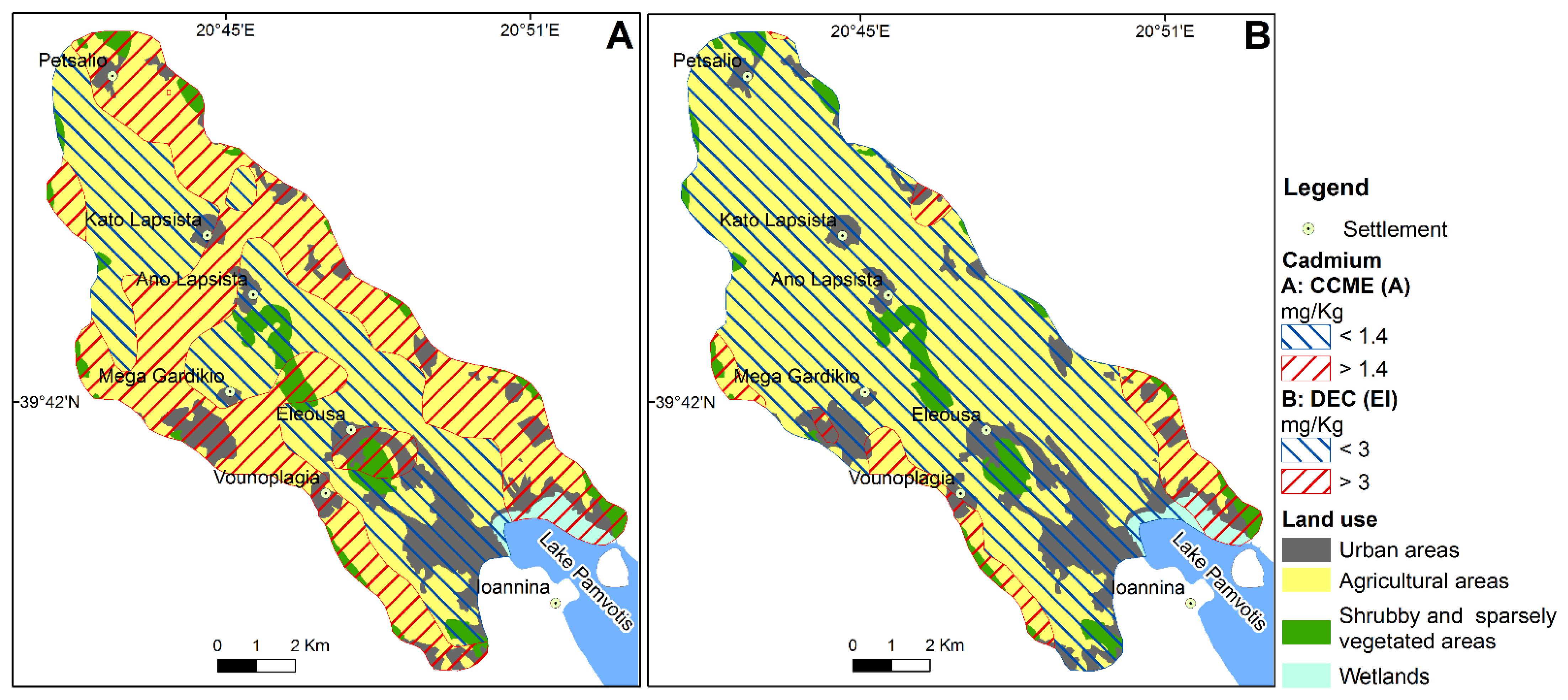
All the sampling sites in Ioannina plain present Cd content in soil lower than the CCME (R) and the residential soil screening level (RS) established by the EPA (Figure 7A), suggesting that there is no potential risk for residents. In contrast, all the sampling sites present Cd concentration in soil higher than the EPA’s plant-avian-mammalian screening level (Figure 5B). In a research study conducted in Kontodespoti-Makrimalli area (Evia island, Greece) following the August 2019 wildfire, it was revealed that Cd content in burned topsoil and ash exceeds the EPA (P,A,M) screening level [35]. In the 54.2% (8.0 km2), 52.7% (41.0 km2), 60% (3.9 km2) and 83.8% (1.3 km2) of the urban, agricultural, shrubby-vegetated and wetlands land use, the Cd content in soil of the study area is well above the soil guideline values for agricultural land use established by the CCME (A) (Figure 7A and Figure 8A). All the sampling sites at the area studied present Cd content in soil lower than the EPA (RS) and CCME (R) (Figure 6A).
The median value of Cd in soil samples of agricultural and urban land use of the area studied is higher than the CCME (A) (Figure 8A). Cadmium content in soil exceeding the DEC (EI) is observed in the 15.7% (2.3 km2), 9.2% (7.2 km2), 19.1% (1.2 km2) and 57% (0.9 km2) of the urban, agricultural, shrubby-vegetated and wetlands areas, respectively (Figure 8B).
The most common effects of Cd on vegetables include a decrease in the number of leaves, a change in root morphology, a reduction in seed germination, a reduction in fruit production and a reduction in the absorption of nitrate [72,73,74]. The common adverse effects of Cd-contaminated vegetables on human health are lung damage and changes in skeletal formation, toxicity to kidneys, endocrine disrupting and irritation of the gastrointestinal system [72,75,76], while the consumption of various types of vegetables controls the level of toxicity of Cd in humans [72]. According to Mahurpawar [77], human exposure also occurs by inhalation of dust derived from Cd contaminated soil. Moreover, chronic inhalation of Cd may cause lung cancer [78]. According to Brooks [79], the general toxicity of Cd to plants is moderate. Furthermore, 3 mg Cd kg−1 in the plants’ tissue depressed growth [80]. If Cd compounds are adsorbed by plants that play a significant role in the food chain; they can accumulate in various human organs [43]. Cadmium poses high threats to human health, soil quality and food safety [81,82].
Moreover, cigarette smoke is considered an important source of Cd exposure [43]. Cadmium tends to accumulate in humans’ liver and kidney [46,80]. Human exposure to Cd compounds may pose a serious health risk [81,82]. The main organ to be affected by Cd in long-term exposure is the kidneys. The biological half-life of Cd ranges from 10 to 30 years [47].
4.3.2. Cobalt
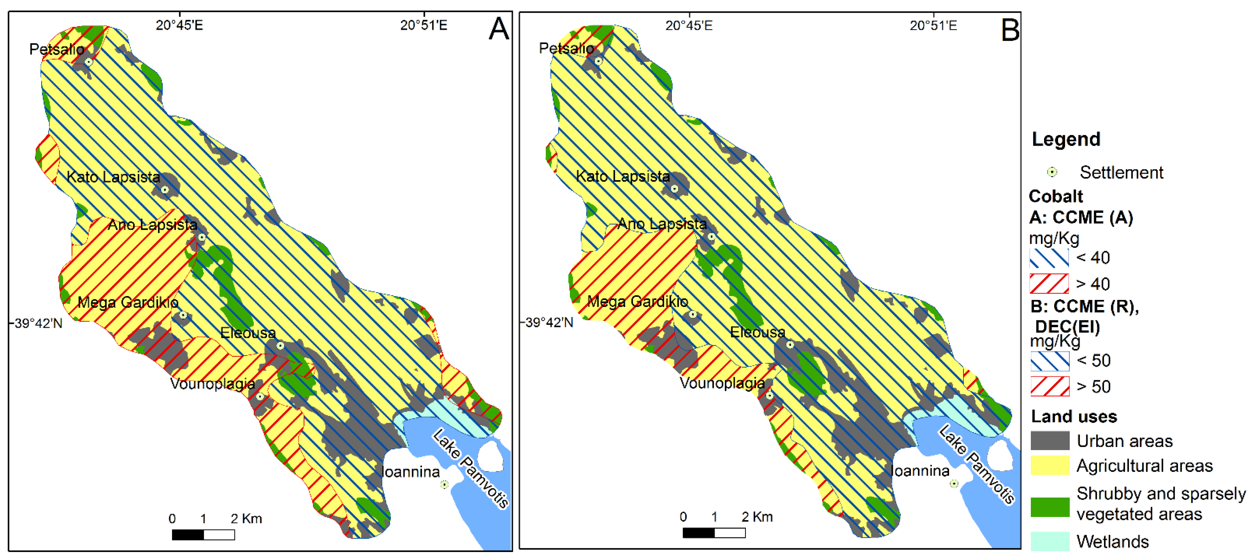
All the sampling sites present Co content in soil higher than EPA (RS) and EPA (P,A,M), suggesting a potential risk to residents and ecological receptors (Figure 7B). In an investigation of land suitability of a Mediterranean site located in Evia island (Greece), Alexakis [35] reported that Co content in topsoil was the limiting factor for residential land use. Moreover, an investigation of land suitability after the July 2018 western Attica wildfire (Kineta area, Greece) revealed that Co concentration in ash was also among the limiting factors for residential land use [34]. Cobalt concentration in soil of the study area exceeding the CCME (A) is observed in the 24.3% (3.6 km2), 28.3% (22.0 km2), 33.1% (2.2 km2) and 1.7% (0.03 km2) of the urban, agricultural, shrubby-vegetated and wetlands area, respectively (Figure 9A).
Cobalt content in soil higher than CCME (R) and DEC (EI) is recorded in 14.5% (2.1 km2), 20.2% (15.7 km2) and 19.4% (1.3 km2) of the urban, agricultural and shrubby-vegetated areas, respectively (Figure 9B).
The expected impacts of Co on plants are the reddish-purple coloration along chlorotic leaf margins, decrease in chlorophyll content and decrease in shoot growth and length [72,83,84]. According to Prashanth et al. [85], the effects of Co on human health are (a) harmful, because it is related to an increase in the incidence of lymphatic and hematopoietic malignancies; and (b) beneficial, because Co is a part of Vitamin B12, which is essential to maintain human health.
The gastrointestinal absorption of Co involves mechanisms common with Fe2+ since people with Fe2+ deficiency show an increased Co absorption [86]. After absorption, Co is mainly accumulated to the heart, spleen, serum, liver and kidneys.
5. Conclusions
Human activities have strongly influenced the land uses of the study area. Thus, the urban and agricultural land covers 92% of the total area. Cadmium and Co are enriched in the Ioannina basin’s topsoil since their median value is higher than that of European soil. The content of Cd in the topsoil of the area studied can be attributed to various anthropogenic sources (traffic emissions, aircraft operations, vehicle crushing and dismantling activities). The observed Cd and Co content in soil at sampling sites located in both the eastern and western edge of the Ioannina plain presented similar spatial distribution, which can be attributed to a common origin or similar dispersion mechanism. The aircraft operations (engine wear), traffic emission and vehicle crushing activities are the most likely anthropogenic source of the high content of Cd and Co in the topsoil of the sampling sites located parallel to the western and eastern edge of the Ioannina plain. This study demonstrates that topsoil in the study area contains toxic elements whose concentration exceeds soil quality guidelines for agricultural land use. Moreover, topsoil contains Co concentration, which may pose a threat to residents and terrestrial ecological receptors. Distribution and delivery of weathering material enriched in Cd and Co from the Ioannina basin to receiving Pamvotis lake may severely affect the lake water and sediments.
Author Contributions
Conceptualization, D.E.A., G.D.B., H.D.S. and D.E.G.; methodology, D.E.A., G.D.B. and H.D.S.; software, H.D.S.; validation, D.E.A., G.D.B. and D.E.G.; formal analysis, D.E.A.; investigation, G.D.B.; resources, H.D.S.; data curation, D.E.G.; writing—original draft preparation, D.E.A. and H.D.S.; writing—review and editing, D.E.A.; visualization, D.E.G.; supervision, D.E.A., G.D.B., H.D.S. and D.E.G. All authors have read and agreed to the published version of the manuscript.
Funding
This research received no external funding.
Institutional Review Board Statement
Not applicable.
Informed Consent Statement
Not applicable.
Data Availability Statement
Data that support the findings of this study are available from the corresponding author upon reasonable request.
Acknowledgments
The authors gratefully acknowledge the staff of IGME for the help rendered during the sampling campaign and laboratory work.
Conflicts of Interest
The authors declare no conflict of interest.
References
- Vingiani, S.; Buonanno, M.; Coraggio, S.; D’Antonio, A.; De Mascellis, R.; Gennaro, A.; Iamarino, M.; Langella, G.; Manna, P.; Moretti, P.; et al. Soils of the Aversa plain (southern Italy). J. Maps 2018, 14, 312–320. [Google Scholar] [CrossRef] [Green Version]
- Langella, G.; Agrillo, A.; Basile, A.; De Mascellis, R.; Manna, P.; Moretti, P.; Mileti, F.A.; Terribile, F.; Vingiani, S. Geography of soil contamination for characterization and precision remediation of potentially contaminated sites. Ital. J. Agron. 2018, 13, 6–15. [Google Scholar]
- Caporale, A.G.; Adamo, P.; Capozzi, F.; Langella, G.; Terribile, F.; Vingiani, S. Monitoring metal pollution in soils using portable-XRF and conventional laboratory-based techniques: Evaluation of the performance and limitations according to metal properties and sources. Sci. Tot. Environ. 2018, 643, 516–526. [Google Scholar] [CrossRef] [PubMed]
- Vingiani, S.; Di Iorio, E.; Colombo, C.; Terribile, F. Integrated study of Red Mediterranean soils from Southern Italy. Catena 2018, 168, 129–140. [Google Scholar] [CrossRef]
- Cabral Pinto, M.M.S.; Ferreira da Silva, E.A. Heavy metals of Santiago island (Cape Verde) alluvial deposits: Baseline value maps and human health risk assessment. Int. J. Environ. Res. Public Health 2019, 16, 2. [Google Scholar] [CrossRef] [Green Version]
- Migiros, G.; Bathrellos, G.D.; Skilodimou, H.D.; Karamousalis, T. Pinios (Peneus) River (Central Greece): Hydrological-Geomorphological elements and changes during the Quaternary. Cent. Eur. J. Geosci. 2011, 3, 215–228. [Google Scholar] [CrossRef]
- Kamberis, E.; Bathrellos, G.; Kokinou, E.; Skilodimou, H. Correlation between the structural pattern and the development of the hydrographic network in a portion of the Western Thessaly basin (Greece). Cent. Eur. J. Geosci. 2012, 4, 416–424. [Google Scholar] [CrossRef] [Green Version]
- Skilodimou, H.D.; Bathrellos, G.D.; Maroukian, H.; Gaki-Papanastassiou, K. Late Quaternary evolution of the lower reaches of Ziliana stream in south Mt. Olympus (Greece). Geogr. Fis. Din. Quat. 2014, 37, 43–50. [Google Scholar]
- Kokinou, E.; Skilodimou, H.D.; Bathrellos, G.D.; Antonarakou, A.; Kamberis, E. Morphotectonic analysis, structural evolution/pattern of a contractional ridge: Giouchtas Mt., Central Crete, Greece. J. Earth Syst. Sci. 2015, 124, 587–602. [Google Scholar]
- Bathrellos, G.D.; Skilodimou, H.D.; Maroukian, H. The significance of tectonism in the glaciations of Greece. Geol. Soc. Spec. Publ. 2017, 433, 237–250. [Google Scholar] [CrossRef]
- Bathrellos, G.D.; Skilodimou, H.D.; Soukis, K.; Koskeridou, E. Temporal and spatial analysis of flood occurrences in drainage basin of Pinios River (Thessaly, central Greece). Land 2018, 7, 106. [Google Scholar] [CrossRef] [Green Version]
- Skilodimou, H.D.; Bathrellos, G.D.; Koskeridou, E.; Soukis, K.; Rozos, D. Physical and anthropogenic factors related to landslide activity in the Northern Peloponnese, Greece. Land 2018, 7, 85. [Google Scholar] [CrossRef] [Green Version]
- Skilodimou, H.D.; Bathrellos, G.D.; Alexakis, D.E. Flood Hazard Assessment Mapping in Burned and Urban Areas. Sustainability 2021, 13, 4455. [Google Scholar] [CrossRef]
- Rozos, D.; Bathrellos, G.D.; Skilodimou, H.D. Comparison of the implementation of Rock Engineering System (RES) and Analytic Hierarchy Process (AHP) methods, based on landslide susceptibility maps, compiled in GIS environment. A case study from the Eastern Achaia County of Peloponnesus, Greece. Environ. Earth Sci. 2011, 63, 49–63. [Google Scholar] [CrossRef]
- Papadopoulou-Vrynioti, K.; Bathrellos, G.D.; Skilodimou, H.D.; Kaviris, G.; Makropoulos, K. Karst collapse susceptibility mapping considering peak ground acceleration in a rapidly growing urban area. Eng. Geol. 2013, 158, 77–88. [Google Scholar] [CrossRef]
- Rozos, D.; Skilodimou, H.D.; Loupasakis, C.; Bathrellos, G.D. Application of the revised universal soil loss equation model on landslide prevention. An example from N. Euboea (Evia) Island, Greece. Environ. Earth Sci. 2013, 70, 3255–3266. [Google Scholar] [CrossRef]
- Chousianitis, K.; Del Gaudio, V.; Sabatakakis, N.; Kavoura, K.; Drakatos, G.; Bathrellos, G.D.; Skilodimou, H.D. Assessment of Earthquake-Induced Landslide Hazard in Greece: From Arias Intensity to Spatial Distribution of Slope Resistance Demand. B. Seismol. Soc. Am. 2016, 106, 174–188. [Google Scholar] [CrossRef]
- Bathrellos, G.D.; Karymbalis, E.; Skilodimou, H.D.; Gaki-Papanastassiou, K.; Baltas, E.A. Urban flood hazard assessment in the basin of Athens Metropolitan city, Greece. Environ. Earth Sci. 2016, 75, 319. [Google Scholar] [CrossRef]
- Bathrellos, G.D.; Kalivas, D.P.; Skilodimou, H.D. Landslide Susceptibility Assessment Mapping: A Case Study in Central Greece. In Remote Sensing of Hydrometeorological Hazards; Petropoulos, G.P., Islam, T., Eds.; CRC Press: Boca Raton, FL, USA; Taylor & Francis Group: London, UK, 2017; pp. 493–512, ISBN-13: 978-1498777582. [Google Scholar]
- Panagopoulos, G.P.; Bathrellos, G.D.; Skilodimou, H.D.; Martsouka, F.A. Mapping urban water demands using multi-criteria analysis and GIS. Water Resour. Manag. 2012, 26, 1347–1363. [Google Scholar] [CrossRef]
- Bathrellos, G.D.; Gaki-Papanastassiou, K.; Skilodimou, H.D.; Papanastassiou, D.; Chousianitis, K.G. Potential suitability for urban planning and industry development using natural hazard maps and geological–geomorphological parameters. Environ. Earth Sci. 2012, 66, 537–548. [Google Scholar] [CrossRef]
- Bathrellos, G.D.; Gaki-Papanastassiou, K.; Skilodimou, H.D.; Skianis, G.A.; Chousianitis, K.G. Assessment of rural community and agricultural development using geomorphological-geological factors and GIS in the Trikala prefecture (Central Greece). Stoch. Environ. Res. Risk A 2013, 27, 573–588. [Google Scholar] [CrossRef]
- Bathrellos, G.D.; Skilodimou, H.D.; Chousianitis, K.; Youssef, A.M.; Pradhan, B. Suitability estimation for urban development using multi-hazard assessment map. Sci. Total Environ. 2017, 575, 119–134. [Google Scholar] [CrossRef]
- Τsolaki-Fiaka, S.; Bathrellos, G.D.; Skilodimou, H.D. Multi-criteria decision analysis for abandoned quarry restoration in Evros Region (NE Greece). Land 2018, 7, 43. [Google Scholar] [CrossRef] [Green Version]
- Skilodimou, H.D.; Bathrellos, G.D.; Chousianitis, K.; Youssef, A.M.; Pradhan, B. Multi-hazard assessment modeling via multi-criteria analysis and GIS: A case study. Environ. Earth Sci. 2019, 78, 47. [Google Scholar] [CrossRef]
- Papadopoulou-Vrynioti, K.; Alexakis, D.; Bathrellos, G.; Skilodimou, H.; Vryniotis, D.; Vassiliades, E. Environmental research and evaluation of agricultural soil of the Arta plain, western Hellas. J. Geochem. Explor. 2014, 136, 84–92. [Google Scholar] [CrossRef]
- Bathrellos, G.D.; Skilodimou, H.D.; Kelepertsis, A.; Alexakis, D.; Chrisanthaki, I.; Archonti, D. Environmental research of groundwater in the urban and suburban areas of Attica region, Greece. Environ. Geol. 2008, 56, 11–18. [Google Scholar] [CrossRef]
- Papadopoulou-Vrynioti, K.; Alexakis, D.; Bathrellos, G.; Skilodimou, H.; Vryniotis, D.; Vassiliades, E.; Gamvroula, D. Distribution of trace elements in stream sediments of Arta plain (western Hellas): The influence of geomorphological parameters. J. Geochem. Explor. 2013, 134, 17–26. [Google Scholar] [CrossRef]
- Makri, P.; Stathopoulou, E.; Hermides, D.; Kontakiotis, G.; Zarkogiannis, S.D.; Skilodimou, H.D.; Bathrellos, G.D.; Antonarakou, A.; Scoullos, M. The Environmental Impact of a Complex Hydrogeological System on Hydrocarbon-Pollutants’ Natural Attenuation: The Case of the Coastal Aquifers in Eleusis, West Attica, Greece. J. Mar. Sci. Eng. 2020, 8, 1018. [Google Scholar] [CrossRef]
- Golfinopoulos, S.; Varnavas, S.; Alexakis, D. The status of arsenic pollution on the Greek and Cyprus environment: An Overview. Water 2021, 13, 224. [Google Scholar] [CrossRef]
- Alexakis, D. Multielement contamination of land in the margin of highways. Land 2021, 10, 230. [Google Scholar] [CrossRef]
- Alexakis, D. Diagnosis of stream sediment quality and assessment of toxic element contamination sources in East Attica, Greece. Environ. Earth Sci. 2011, 63, 1369–1383. [Google Scholar] [CrossRef]
- Alexakis, D. Human health risk assessment associated with Co, Cr, Mn, Ni and V contents in agricultural soils from a Mediterranean site. Arch. Agron. Soil Sci. 2016, 62, 359–373. [Google Scholar] [CrossRef]
- Alexakis, D. Suburban areas in flames: Dispersion of potentially toxic elements from burned vegetation and buildings. Estimation of the associated ecological and human health risk. Environ. Res. 2020, 183, 109153. [Google Scholar] [CrossRef] [PubMed]
- Alexakis, D. Contaminated land by wildfire effect on ultramafic soil and associated human health and ecological risk. Land 2020, 9, 409. [Google Scholar] [CrossRef]
- Alexakis, D.; Gotsis, D.; Giakoumakis, S. Assessment of drainage water quality in pre- and post-irrigation seasons for supplemental irrigation use. Environ. Monit. Assess. 2012, 184, 5051–5063. [Google Scholar] [CrossRef] [PubMed]
- Alexakis, D.; Gotsis, D.; Giakoumakis, S. Evaluation of soil salinization in a Mediterranean site (Agoulinitsa district—West Greece). Arab. J. Geosci. 2015, 8, 1373–1383. [Google Scholar] [CrossRef]
- Kelepertsis, A.; Alexakis, D.; Kita, I. Environmental geochemistry of soils and waters of Susaki area, Korinthos, Greece. Environ. Geochem. Health 2001, 23, 117–135. [Google Scholar] [CrossRef]
- Kelepertsis, A.; Alexakis, D. The impact of mining and metallurgical activity of the Lavrion sulfide deposits on the geochemistry of bottom sea sediments East of the Lavreotiki Peninsula, Greece. Res. J. Chem. Environ. 2004, 8, 40–46. [Google Scholar]
- Gamvroula, D.; Alexakis, D.; Stamatis, G. Diagnosis of groundwater quality and assessment of contamination sources in the Megara basin (Attica, Greece). Arab. J. Geosci. 2013, 6, 2367–2381. [Google Scholar] [CrossRef]
- Nguyen, T.T.; Verdoodt, A.; Tran, V.Y.; Delbecque, N.; Tran, T.C.; Van Ranst, E. Design of a GIS and multi-criteria based land evaluation procedure for sustainable land-use planning at the regional level. Agric. Ecosyst. Environ. 2015, 200, 1–11. [Google Scholar] [CrossRef]
- Safari, Y.; Delavar, M.-A. The influence of soil pollution by heavy metals on the land suitability for irrigated wheat farming in Zanjan region, northwest Iran. Arab. J. Geosc. 2019, 12, 21. [Google Scholar] [CrossRef]
- Taghizadeh-Mehrjardi, R.; Nabiollahi, K.; Rasoli, L.; Kerry, R.; Scholten, T. Land suitability assessment and agricultural production sustainability using machine learning models. Agronomy 2020, 10, 573. [Google Scholar] [CrossRef]
- Chibuike, G.U.; Obiora, S.C. Heavy metal polluted soils: Effect on plants and bioremediation methods. Appl. Environ. Soil Sci. 2014, 2014, 752708. [Google Scholar] [CrossRef] [Green Version]
- Chatterjee, J.; Chatterjee, C. Phytotoxicity of cobalt, chromium and copper in cauliflower. Environ. Pollut. 2000, 109, 69–74. [Google Scholar] [CrossRef]
- Gough, L.P.; Shacklette, H.T.; Case, A.A. Element concentrations toxic to plants, animals, and man. Geol. Surv. Bull. 1979, 1466. [Google Scholar] [CrossRef]
- Berglund, M.; Larsson, K.; Grandér, M.; Casteleyn, L.; Kolossa-Gehring, M.; Schwedler, G.; Castano, A.; Esteban, M.; Angerer, J.; Koch, H.M.; et al. Exposure determinants of cadmium in European mothers and their children. Environ. Res. 2015, 141, 64–76. [Google Scholar] [CrossRef]
- Papadopoulou-Vrynioti, K.; Mertzanis, A.; Vryniotis, D.; Vassiliades, E.; Karakitsios, V. The contribution of karstic rocks to soil quality, Ioannina plain (Epirus, Hellas). J. Geochem. Explor. 2015, 154, 224–237. [Google Scholar] [CrossRef]
- Hellenic Civil Aviation Authority (HCAA). Statistical Data of Ioannina Airport for the Period 1994–2018. 2021. Available online: http://www.hcaa.gr/en/our-airports/kratikos-aerolimenas-iwanninwn-basileys-pyrros-kaiwp (accessed on 20 March 2021).
- IGME (Institute of Geology and Mineral Exploration). Geological Maps of Greece, Sheet Ioannina, scale 1:50,000. 1967. Available online: https://shop.geospatial.com/product/03-GRAC-Greece-50000-Geological-Maps (accessed on 20 March 2021).
- Karakitsios, V. The influence of preexisting structure and halokinesis on organic matter preservation and thrust system evolution in the Ionian basin, northwest Greece. AAPG Bull. 1995, 79, 960–980. [Google Scholar]
- Karakitsios, V. Western Greece and Ionian Sea petroleum systems. AAPG Bull. 2013, 97, 1567–1595. [Google Scholar] [CrossRef] [Green Version]
- Gentzis, T.; Goodarzi, F.; Foscolos, A. Geochemistry and mineralogy of Greek lignites from the Ioannina basin. Energ. Source 1997, 19, 111–128. [Google Scholar] [CrossRef]
- Roucoux, K.H.; Tzedakis, P.C.; Lawson, I.T.; Margari, V. Vegetation history of the penultimate glacial period (MIS 6) at Ioannina, northwest Greece. J. Quat. Sci. 2011, 26, 616–626. [Google Scholar] [CrossRef]
- Vryniotis, D. Soil Geochemical- Environmental Survey of the N.W. Part of the Ioannina Basin; Open File Report, I.G.M.E.: Athens, Greece, 2010; p. 95. (In Greek) [Google Scholar]
- Soil Atlas of Europe, European Soil Bureau Network European Commission. 128 pp Office for Official Publications of the European Communities, L-2995 Luxembourg. 2005. Available online: https://esdac.jrc.ec.europa.eu/content/soil-atlas-europe (accessed on 2 June 2021).
- Copernicus. Urban Atlas 2018. Copernicus Land Monitoring Service. 2021. Available online: https://land.copernicus.eu/local/urban-atlas/urban-atlas-2018 (accessed on 20 March 2021).
- Salminen, R.; Batista, M.J.; Bidovec, M.; Demetriades, A.; De Vivo, B.; De Vos, W.; Duris, M.; Gilucis, A.; Gregorauskiene, V.; Halamić, J.; et al. Geochemical Atlas of Europe. Part 1—Background Information, Methodology and Maps. 2005. Available online: http://weppi.gtk.fi/publ/foregsatlas (accessed on 20 March 2021).
- EPA (Environmental Protection Agency). Cleanup Regulations and Standards. Available online: http://www.epa.gov/cleanup/regs.htm (accessed on 20 March 2021).
- CCME (Canadian Council of Ministers of the Environment). Available online: http://st-ts.ccme.ca (accessed on 20 March 2021).
- DEC (Department of Environment and Conservation). Contaminated Sites Management Series: Assessment Levels for Soil, Sediment and Water. 2010. Available online: http://www.dec.wa.gov.au/contaminatedsites (accessed on 20 March 2021).
- Liu, K.; Lv, J.; He, W.; Zhang, H.; Cao, Y.; Dai, Y. Major factors influencing cadmium uptake from the soil into wheat plants. Ecotoxic. Environ. Saf. 2015, 113, 207–213. [Google Scholar] [CrossRef] [PubMed]
- Romic, M.; Romic, D. Heavy metals distribution in agricultural topsoils in urban area. Environ. Geol. 2003, 43, 795–805. [Google Scholar] [CrossRef]
- Jaradat, Q.M.; Masadeh, A.; Zaitoun, M.; Maitah, B. Heavy metal contamination of soil, plant and air of scrapyard of discarded vehicles at Zarqa city, Jordan. Soil Sed. Contam. An. Intern. J. 2005, 14, 449–462. [Google Scholar] [CrossRef]
- Agrawal, H.; Sawanta, A.; Jansen, K.; Miller, J.W.; Cocker, D.R. Characterization of chemical and particulate emissions from aircraft engines. Atmos. Environ. 2008, 42, 4380–4392. [Google Scholar] [CrossRef]
- Nunes, L.M.; Stigter, T.Y.; Teixeira, M.R. Environmental impacts on soil and groundwater at airports: Origin, contaminants of concern and environmental risks. J. Environ. Monit. 2011, 13, 3026–3039. [Google Scholar] [CrossRef]
- Wiseman, C.L.S.; Zereini, F.; Püttmann, W. Traffic-related trace element fate and uptake by plants cultivated in roadside soils in Toronto, Canada. Sci. Tot. Environ. 2013, 442, 86–95. [Google Scholar] [CrossRef]
- Abegglen, M.; Brem, B.T.; Ellenrieder, M.; Durdina, L.; Rindlisbacher, T.; Wang, J.; Lohmann, U.; Sierau, B. Chemical characterization of freshly emitted particulate matter from aircraft exhaust using single particle mass spectrometry. Atmos. Environ. 2016, 134, 181–197. [Google Scholar] [CrossRef]
- Amato, F.; Moreno, T.; Pandolfi, M.; Querol, X.; Alastuey, A.; Delgado, A.; Pedrero, M.; Cots, N. Concentrations, sources and geochemistry of airborne particulate matter at a major European airport. J. Environ. Monit. 2010, 12, 854–862. [Google Scholar] [CrossRef] [Green Version]
- Brtnick, M.; Pecina, V.; Galiova, M.V.; Prokes, L.; Zverina, O.; Juricka, D.; Klimanek, M.; Kynicky, J. The impact of tourism on extremely visited volcanic island: Link between environmental pollution and transportation modes. Chemosphere 2020, 249, 126118. [Google Scholar] [CrossRef]
- Lange, C.N.; Figueiredo, A.G.; Enzweiler, J.; Castro, L. Trace elements status in the terrain of an impounded vehicle scrapyard. J. Radioanal. Nucl. Chem. 2017, 311, 1323–1332. [Google Scholar] [CrossRef]
- Gupta, N.; Yadav, K.K.; Kumar, V.; Kumar, S.; Chadd, R.P.; Kumar, A. Trace elements in soil-vegetables interface: Translocation, bioaccumulation, toxicity and amelioration—A review. Sci. Tot. Environ. 2019, 651, 2927–2942. [Google Scholar] [CrossRef] [PubMed]
- Yourtchi, M.S.; Bayat, H.R. Effect of cadmium toxicity on growth, cadmium accumulation and macronutrient content of durum wheat (Dena CV). Int. J. Agric. Crop. Sci. 2013, 6, 1099–1103. [Google Scholar]
- Hediji, H.; Djebali, W.; Belkadhi, A.; Cabasson, C.; Moing, A.; Rolin, D.; Brouquisse, R.; Gallusci, P.; Chaibi, W. Impact of long-term cadmium exposure on mineral content of Solanum lycopersicum plants: Consequences on fruit production. S. Afr. J. Bot. 2015, 97, 176–181. [Google Scholar] [CrossRef]
- Food Safety Authority of Ireland. Mercury, Lead, Cadmium, Tin and Arsenic in Food; Toxicology Factsheet Series; Food Safety Authority of Ireland: Dublin, Ireland, 2009; pp. 1–13. [Google Scholar]
- Rahman, A.; Kumarathasan, P.; Gomes, J. Infant and mother related outcomes from exposure to metals with endocrine disrupting properties during pregnancy. Sci. Total Environ. 2016, 56, 1022–1031. [Google Scholar] [CrossRef]
- Mahurpawar, M. Effects of heavy metals on human health. Int. J. Res. Granthaalayah 2015, 3, 1–7. [Google Scholar] [CrossRef]
- Goyer, R.; Golub, M.; Choudhury, H.; Hughes, M.; Kenyon, E.; Stifelman, M. Issue Paper on the Human Health Effects of Metals. 2004. Available online: https://www.epa.gov/osa/issue-paper-human-health-effects-metals (accessed on 20 March 2021).
- Brooks, R.R. Geobotany and Biogeochemistry in Mineral. Exploration, 1st ed.; Harper & Row: New York, NY, USA, 1972; p. 290. [Google Scholar]
- Alloway, W.H. Agronomic controls over the environmental cycling of trace elements. Adv. Agron. 1968, 20, 235–274. [Google Scholar]
- Khan, M.A.; Khan, S.; Khana, A.; Alam, M. Soil contamination with cadmium, consequences and remediation using organic amendments. Sci. Tot. Environ. 2017, 601–602, 1591–1605. [Google Scholar] [CrossRef]
- Rafati Rahimzadeh, M.; Rafati Rahimzadeh, M.; Kazemi, S.; Moghadamnia, A.A. Cadmium toxicity and treatment: An update. Casp. J. Intern. Med. 2017, 8, 135–145. [Google Scholar]
- Pandey, N.; Sharma, C.P. Effect of heavy metals Co2+, Ni2+ and Cd2+ on growth and metabolism of cabbage. Plant. Sci. 2002, 163, 753–758. [Google Scholar] [CrossRef]
- Li, H.F.; Gray, C.; Mico, C.; Zhao, F.J.; McGrath, S.P. Phytotoxicity and bioavailability of cobalt to plants in a range of soils. Chemosphere 2009, 75, 979–986. [Google Scholar] [CrossRef] [PubMed]
- Prashanth, L.; Kattapagari, K.K.; Chitturi, R.T.; Baddam, V.R.; Prasad, L.K. A review on role of essential trace elements in health and disease. J. NTR Univ. Health Sci. 2015, 4, 75–85. [Google Scholar]
- Valberg, L.S.; Ludwig, J.; Olatunbosun, D. Alteration in cobalt absorption in patients with disorders of iron metabolism. Gastroenterology 1969, 56, 241–251. [Google Scholar] [CrossRef]
Figure 1.
(A) Location map of the study area; (B) road network, drainage network and elevation of the study area.
Figure 1.
(A) Location map of the study area; (B) road network, drainage network and elevation of the study area.

Figure 2.
Geological map of the area studied.

Figure 3.
Land use in the Ioannina plain.

Figure 4.
Map showing soil sampling sites in the Ioannina plain.

Figure 5.
Graduated symbol plots of Cd content in soil of Ioannina plain concerning land uses (A) and geology (B).
Figure 5.
Graduated symbol plots of Cd content in soil of Ioannina plain concerning land uses (A) and geology (B).

Figure 6.
Graduated symbol plots of Co content in soil of Ioannina plain concerning land uses (A) and geology (B).
Figure 6.
Graduated symbol plots of Co content in soil of Ioannina plain concerning land uses (A) and geology (B).

Figure 7.
Boxplots for (A) Cd and (B) Co, comparing element concentration to guideline established by the literature (EPA, CCME and DEC). EPA (RS): Residential soil regional screening level, EPA (P,A,M): plant-avian-mammalian screening level, EPA (A,M): avian-mammalian screening level, CCME (A): soil quality guideline for agricultural land use, CCME (R): soil quality guideline for residential land use; DEC (EI): ecological investigation level.

Figure 8.
Suitability map comparing Cd content in soil of the study area to: (A) CCME (A); and (B) DEC (EI).
Figure 8.
Suitability map comparing Cd content in soil of the study area to: (A) CCME (A); and (B) DEC (EI).

Figure 9.
Suitability map comparing Co content in soil of the study area to: (A) CCME (A); and (B) CCME (R).
Figure 9.
Suitability map comparing Co content in soil of the study area to: (A) CCME (A); and (B) CCME (R).


Table 1.
Detection limits, descriptive statistics of Cd and Co concentration (in mg kg−1) in soil gathered from the Ioannina plain, and criteria obtained from the literature.
Table 1.
Detection limits, descriptive statistics of Cd and Co concentration (in mg kg−1) in soil gathered from the Ioannina plain, and criteria obtained from the literature.
| Cd | Co | |
|---|---|---|
| Detection limit | 0.2 | 0.3 |
| Agricultural land use (n = 102) | ||
| Mean | 1.7 | 30.8 |
| Median | 1.5 | 23.5 |
| Minimum | 0.3 | 4.0 |
| Maximum | 5.1 | 90.0 |
| Urban land use (n = 8) | ||
| Mean | 2.0 | 37.1 |
| Median | 1.7 | 35.5 |
| Minimum | 0.3 | 7.0 |
| Maximum | 3.6 | 77.0 |
| Wetlands (n = 2) | ||
| Minimum | 3.2 | 33.0 |
| Maximum | 3.7 | 35.0 |
| European topsoil [58] | 0.145 | 7.0 |
| EPA Residential soil [59] | 7.1 | 2.3 |
| EPA Plant-Avian-Mammalian [59] | 0.00222 | 0.14 |
| CCME Agricultural land use [60] | 1.4 | 40 |
| CCME Residential land use [60] | 10 | 50 |
| DEC Ecological Investigation level [61] | 3 | 50 |
Table 2.
The land uses of the study area, their area in km2 and percentage proportion (%).
| Land Uses | Area (km2) | Area (%) |
|---|---|---|
| Urban areas | 14.8 | 15 |
| Agricultural areas | 77.8 | 77 |
| Shrub and sparsely vegetation areas | 6.6 | 6 |
| Wetlands | 1.6 | 2 |
| Total | 100.8 | 100 |
Publisher’s Note: MDPI stays neutral with regard to jurisdictional claims in published maps and institutional affiliations. |
© 2021 by the authors. Licensee MDPI, Basel, Switzerland. This article is an open access article distributed under the terms and conditions of the Creative Commons Attribution (CC BY) license (https://creativecommons.org/licenses/by/4.0/).
Share and Cite
MDPI and ACS Style
Alexakis, D.E.; Bathrellos, G.D.; Skilodimou, H.D.; Gamvroula, D.E. Land Suitability Mapping Using Geochemical and Spatial Analysis Methods. Appl. Sci. 2021, 11, 5404. https://doi.org/10.3390/app11125404
AMA Style
Alexakis DE, Bathrellos GD, Skilodimou HD, Gamvroula DE. Land Suitability Mapping Using Geochemical and Spatial Analysis Methods. Applied Sciences. 2021; 11(12):5404. https://doi.org/10.3390/app11125404
Chicago/Turabian StyleAlexakis, Dimitrios E., George D. Bathrellos, Hariklia D. Skilodimou, and Dimitra E. Gamvroula. 2021. "Land Suitability Mapping Using Geochemical and Spatial Analysis Methods" Applied Sciences 11, no. 12: 5404. https://doi.org/10.3390/app11125404
Note that from the first issue of 2016, this journal uses article numbers instead of page numbers. See further details here.