

The Current State of Irrigated Soils in the Central Fergana Desert under the Effect of Anthropogenic Factors

 ,
,  , ,
, ,
Abstract
:1. Introduction
2. Materials and Methods
3. Results and Discussions
- (1)
- Surface planning of rugged terrains in a natural state—agrogenic transformation of relief;
- (2)
- Land irrigation, introduction of irrigation water into agro-ecosystems, which leads to the deposition of limestone-silt sediments and salts;
- (3)
- Changes in the water–salt regime due to the construction of collector–drainage networks;
- (4)
- Complex measures, such as land treatment systems, the replacement of natural vegetation by crops in crop rotation, the implementation of fertilizer systems;
- (5)
- Flush irrigation and other similar hydromeliorative and agromeliorative measures have been implemented;
- (6)
- Secondary salinization that increases arable density;
- (7)
- The initial stage of drainage processes on newly-developed lands is accelerated, etc.
4. Conclusions
Author Contributions
Funding
Institutional Review Board Statement
Informed Consent Statement
Data Availability Statement
Acknowledgments
Conflicts of Interest
References
- Ivanov, I.B.; Kudeyarov, V.N. Evolution of Soils and Soil Cover: Theory, Diversity of Natural Evolution and Anthropogenic Soil Transformations; GEOS: Moscow, Russia, 2015; p. 924. [Google Scholar]
- Menci, A.A.; Klavdienko, K.M. Soils of Central Fergana (Yaz-Yavan-Boston-Sharikhan massive); Nauka: Tashkent, Uzbekistan, 1931. [Google Scholar]
- Umarov, M.U. Soils of Uzbekistan; Fan: Tashkent, Uzbekistan, 1975; p. 224. [Google Scholar]
- Maksudov, A. Changes in depth and salinity of groundwater in Central Fergana under the influence of irrigation. In Problems of Geography, Chemistry, Physics and Biology of Soils; Nauka: Tashkent, Uzbekistan, 1974; pp. 183–186. [Google Scholar]
- Maksudov, A. Soils of Central Fergana and Their Changes as a Result of Irrigation; Nauka: Tashkent, Uzbekistan, 1979; p. 120. [Google Scholar]
- Pankov, M.A. Soils of Fergana province. In Soils of Uzbek SSR; Publishing House of Academy of Sciences of Uzbek SSR: Tashkent, Uzbekistan, 1957; p. 159. [Google Scholar]
- Kovda, V.A. Problems of Combating Desertification and Salinization of Irrigated Soils; Kolos: Moscow, Russia, 1984; p. 304. [Google Scholar]
- Turdaliev, A.T.; Yuldashev, G. Geochemistry of Pedolithic Soils: Monograph; Fan: Tashkent, Uzbekistan, 2015; p. 200. [Google Scholar]
- Abakumov, E.; Yuldashev, G.; Darmonov, D.; Turdaliev, A.; Askarov, K.; Khaydarov, M.; Mirzayev, U.; Nizamutdinov, T.; Davronov, K. Influence of Mineralized Water Sources on the Properties of Calcisol and Yield of Wheat (Triticum aestivum L.). Plants 2022, 11, 3291. [Google Scholar] [CrossRef]
- Isagaliev, M.; Abakumov, E.; Turdaliev, A.; Obidov, M.; Khaydarov, M.; Abdukhakimova, K.; Shermatov, T.; Musaev, I. Capparis spinosa L. Cenopopulation and Biogeochemistry in South Uzbekistan. Plants 2022, 11, 1628. [Google Scholar] [CrossRef] [PubMed]
- Turdaliev, A.T.; Askarov, K.A.; Mirzaev, F.A. Morphological features of the irrigated soils in Central Fergana. J. Soils Environ. 2019, 2, e71. [Google Scholar] [CrossRef]
- Kholdarov, D.; Urmanov, S.; Sobirov, A.; Turdimatova, G. Migration of microelements in soils of Ferghana valley and advantages of using them. Sci. Innov. 2023, 2, 108–114. [Google Scholar] [CrossRef]
- IUSS Working Group WRB. World Reference Base for Soil Resources 2014, Update 2015. International Soil Classification System for Naming Soils and Creating Legends for Soil Maps; World Soil Resources Reports No. 106; FAO: Rome, Italy, 2015; p. 203. [Google Scholar]
- Turdaliev, A.; Yuldashev, G.; Askarov, K.; Abakumov, E. Chemical and biochemical features of desert soils of the Central Fergana. Agriculture 2021, 67, 16–28. [Google Scholar] [CrossRef]
- Mirzazhanov, K.M.; Paganyas, K.P.; Kamilov, B.S. Soil formation on the sands of Central Fergana. Eurasian Soil Sci. 1993, 25, 101–104. [Google Scholar]
- Isakov, V.Y.; Mirzaev, U.B.; Yusupova, M.A. Peculiarities of Soil Characteristics of Sandy Massifs of Fergana Valley. Scientific Review. Biol. Sci. 2020, 1, 15–19. [Google Scholar]
- Stulina, G.; Cameira, M.R.; Pereira, L.S. Using RZWQM to search improved practices for irrigated maize in Fergana, Uzbekistan. Agric. Water Manag. 2005, 77, 263–281. [Google Scholar] [CrossRef]
- Smalley, I.J.; Mavlyanova, N.G.; Rakhmatullaev, K.H.L.; Shermatov, M.S.H.; Machalett, B.; Dhand, K.; O’hara Jefferson, I.F. The formation of loess deposits in the Tashkent region and parts of Central Asia; and problems with irrigation, hydrocollapse and soil erosion. Quat. Int. 2006, 152–153, 59–69. [Google Scholar] [CrossRef]
- Evett, S.; Ibragimov, N.; Kamilov, B.; Esanbekov, Y.; Sarimsakov, M.; Shadmanov, J.; Mirhashimov, R.; Musaev, R.; Radjabov, T.; Muhammadiev, B. Neutron Moisture Meter Calibration in Six Soils of Uzbekistan Affected by Carbonate Accumulation. Vadose Zone J. 2007, 6, 406–412. [Google Scholar] [CrossRef] [Green Version]
- Karimov, A.K.; Šimůnek, J.; Hanjra, M.A.; Avliyakulov, M.; Forkutsa, I. Effects of the shallow water table on water use of winter wheat and ecosystem health: Implications for unlocking the potential of groundwater in the Fergana Valley (Central Asia). Agric. Water Manag. 2014, 131, 57–69. [Google Scholar] [CrossRef]
- Kenjabaev, S.H.; Frede, H.G.; Begmatov, I.; Isaev, S.; Matyakubov, B. Determination of actual crop evapotranspiration (ETC) and dual crop coefficients (KC) for cotton, wheat and maize in Fergana Valley: Integration of the FAO-56 approach and budget. J. Crit. Rev. 2020, 7, 340–349. [Google Scholar]
- Kulikov, M.; Schickhoff, U.; Gröngröft, A.; Borchardt, P. Modelling soil erodibility in mountain rangelands of southern Kyrgyzstan. Pedosphere 2020, 30, 443–456. [Google Scholar] [CrossRef]
- Arnold, R.V. Detailed Soil Survey in the USA. Eurasian Soil Sci. 1990, 2, 21–29. [Google Scholar]
- Pankova, E.I. Salinization of soils of Djizak steppe, patterns of its distribution and assessment criteria. Eurasian Soil Sci. 1982, 4, 90–100. [Google Scholar]
- Nurmatov, S.H. Aggregate Composition of Colloidal Particles of Gray-Brown Soils Subjected to Irrigation Erosion. In Proceedings of the Land Management and Evaluation: New Approaches and Innovative Solutions (Russian-Uzbek Scientific and Practical Conference), Tashkent, Uzbekistan, 22–24 April 2019; Alikhanov, B.B., Abdyllayev, A.H., Isayev, O.B., Eds.; National University of Uzbekistan: Tashkent, Uzbekistan, 2019; pp. 74–78. [Google Scholar]
- Brevik, E.C.; Hartemink, A.E. Soil Maps of the United States of America. Soil Sci. Soc. Am. J. 2013, 77, 1117–1132. [Google Scholar] [CrossRef] [Green Version]
- Ali, S.; Khan, N. Evaluation of Morphometric Parameters—A Remote Sensing and GIS Based Approach. Open J. Mod. Hydrol. 2013, 3, 20–27. [Google Scholar] [CrossRef] [Green Version]
- Bockheim, J.G.; Hartemink, A.E. Classification and distribution of soils with lamellae in the USA. Geoderma 2013, 206, 92–100. [Google Scholar] [CrossRef]
- Razakov, A.M.; Madrimov, R.M.; Gafurova, L.A. Evolution and use of gray-brown soils. In Proceedings of the Land Management and Evaluation: New Approaches and Innovative Solutions (Russian-Uzbek Scientific and Practical Conference), Tashkent, Uzbekistan, 22–24 April 2019; Alikhanov, B.B., Abdyllayev, A.H., Isayev, O.B., Eds.; National University of Uzbekistan: Tashkent, Uzbekistan, 2019; pp. 595–599. [Google Scholar]
- Watts, C.; Collins, M.E. Soils of Florida; Soil Science Society of America: Madison, WI, USA, 2008. [Google Scholar]
- Makeev, A.O.; Dubrovina, I.V. Geography, genesis and evolution of soils of Vladimir Opolye. Eurasian Soil Sci. 1990, 7, 5–25. [Google Scholar]
- Luk’yanchikova, Z.I. Content and composition of humus in soils under intensive farming. Eurasian Soil Sci. 1980, 6, 78–90. [Google Scholar]
- FAO. Standard Operating Procedure for Soil Organic Carbon Walkley-Black Method: Titration and Colorimetric Method; FAO: Rome, Italy, 2019; p. 27. [Google Scholar]
- Arinushkina, E.V. Guidance on Chemical Analysis of Soils; Moscow State University: Moscow, Russia, 1970; p. 489. [Google Scholar]
- Shein, E.V. Field and Laboratory Methods for Studying Physical Soil Physical Properties and Regimes; MSU: Moscow, Russia, 2001; p. 200. [Google Scholar]
- Yuldashev, G.; Isagaliev, M.T. Biogeochemistry of Soils; Fan: Tashkent, Uzbekistan, 2014; p. 320. [Google Scholar]
- Isakov, V.Y.; Mirzaev, U.B. Properties of Arzik Soils Formed in Central Fergana and Their Changes under the Influence of Anthropogenic Factor; Fan: Tashkent, Uzbekistan, 2009; p. 228. [Google Scholar]
- Gagarina, E.I. Lithological Factor of Soil Formation: (On the Example of the North-West of the Russian Plain); Publishing House of Saint-Petersburg State University: Saint-Petersburg, Russia, 2004; p. 257. [Google Scholar]
- Orlov, D.S. Chemistry of Soils; Moscow State University Press: Moscow, Russia, 1985; p. 376. [Google Scholar]
- Petelko, A.I. Influence of water erosion on agrochemical and physical properties of soils. Agrochem. Bull. 2007, 5, 5–7. [Google Scholar]
- Dragan, N.A. The ratio of natural and anthropogenic negative processes in the soils of the Crimea. Sci. Notes Crime. Fed. Univ. Named V. I. Vernadsky. Geogr. 2008, 3, 148–160. [Google Scholar]
- Porta, J. Methodologies for the analysis and characterization of gypsum in soils: A review. Geoderma 1998, 87, 31–46. [Google Scholar] [CrossRef]
- Kuttah, D.; Sato, K. Review on the effect of gypsum content on soil behavior. Transp. Geotech. 2015, 4, 28–37. [Google Scholar] [CrossRef]
- Jafarzadeh, A.A.; Burnham, C.P. Gypsum crystals in soils. J. Soil Sci. 1992, 43, 409–420. [Google Scholar] [CrossRef]


| Soil Section | Depth, cm | Horizon | TOC, % | C/N | Bulk Content, % | ||
|---|---|---|---|---|---|---|---|
| N | P2O5 | K2O | |||||
| 1 | 0–37 | PJ | 0.94 | 9.40 | 0.10 | 0.27 | 1.28 |
| 37–69 | BCAmc | 0.48 | 9.60 | 0.05 | 0.15 | 1.02 | |
| 69–87 | BCAnc | 0.24 | 12.00 | 0.02 | 0.04 | 0.48 | |
| 2 | 0–32 | PJ | 1.37 | 10.53 | 0.13 | 0.29 | 1.20 |
| 32–45 | BCAmc | 0.62 | 6.89 | 0.09 | 0.19 | 0.96 | |
| 45–110 | BCAnc | 0.13 | 6.50 | 0.02 | 0.09 | 0.51 | |
| 3 | 0–30 | PJ | 0.95 | 6.78 | 0.14 | 0.27 | 1.44 |
| 30–44 | BCA | 0.50 | 5.55 | 0.09 | 0.18 | 0.98 | |
| 44–90 | BCA | 0.19 | 6.33 | 0.03 | 0.10 | 0.63 | |
| 4 | 0–36 | PJ | 0.83 | 6.38 | 0.13 | 0.24 | 1.38 |
| 36–70 | BCA | 0.63 | 7.00 | 0.09 | 0.17 | 1.11 | |
| 70–104 | Cca | 0.24 | 6.00 | 0.04 | 0.14 | 0.57 | |
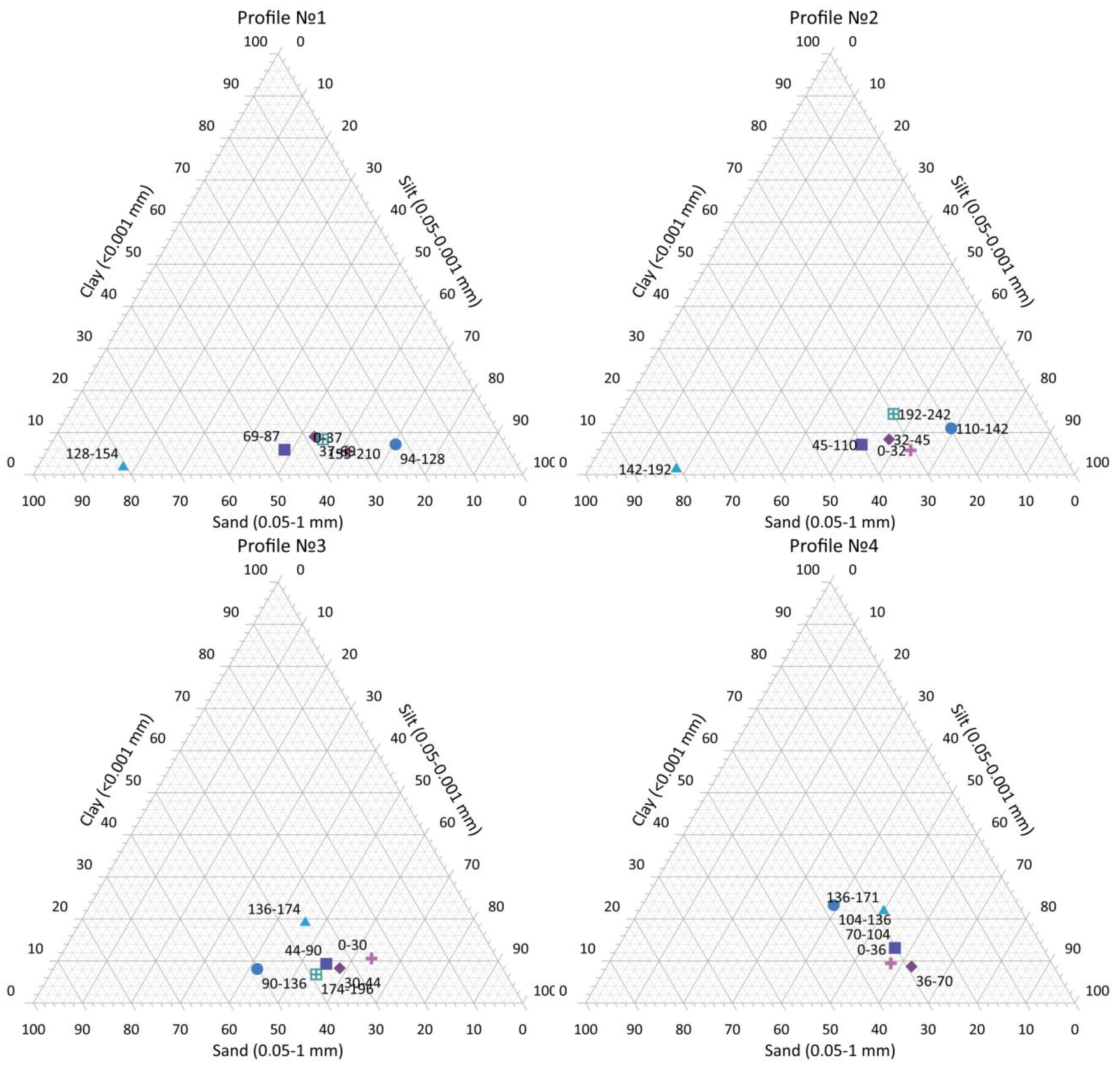
| Section Number | Depth, cm | Fraction Content, % | ||||||||
|---|---|---|---|---|---|---|---|---|---|---|
| Horizon | 1.0–0.25 | 0.25–0.10 | 0.10–0.05 | 0.05–0.01 | 0.01–0.005 | 0.005–0.001 | <0.001 | <0.01 | ||
| 1 | 0–37 | PJ | 1.58 | 12.50 | 19.07 | 38.24 | 15.15 | 7.90 | 5.56 | 28.61 |
| 37–69 | BCAmc | 6.55 | 17.22 | 14.28 | 16.05 | 13.80 | 23.08 | 9.02 | 45.90 | |
| 69–87 | BCAnc | 11.97 | 23.14 | 10.62 | 21.22 | 11.04 | 16.10 | 5.91 | 33.05 | |
| 94–128 | Cca | 8.03 | 10.22 | 4.14 | 22.35 | 18.42 | 29.65 | 7.19 | 55.26 | |
| 128–154 | Cca | 21.32 | 48.95 | 10.50 | 11.11 | 4.00 | 2.34 | 1.78 | 8.12 | |
| 155–210 | Cca | 3.43 | 15.20 | 18.00 | 36.12 | 8.98 | 9.87 | 8.40 | 27.25 | |
| 2 | 0–32 | PJ | 1.39 | 11.97 | 17.29 | 38.17 | 16.60 | 8.78 | 5.80 | 31.18 |
| 32–45 | BCAmc | 5.10 | 15.80 | 12.90 | 17.91 | 14.54 | 25.38 | 8.37 | 48.29 | |
| 45–110 | BCAnc | 10.85 | 20.32 | 8.87 | 23.22 | 12.60 | 17.02 | 7.12 | 36.74 | |
| 110–142 | Cca | 5.71 | 11.23 | 2.84 | 21.15 | 18.42 | 29.65 | 11.00 | 59.07 | |
| 142–192 | Cca | 23.12 | 45.12 | 8.57 | 10.17 | 4.15 | 2.62 | 1.27 | 8.04 | |
| 192–242 | Cca | 1.33 | 12.29 | 16.23 | 33.07 | 10.75 | 11.87 | 14.40 | 37.02 | |
| 3 | 0–30 | PJ | 3.50 | 5.00 | 17.10 | 33.70 | 9.40 | 20.70 | 10.60 | 40.70 |
| 30–44 | BCA | 5.30 | 5.10 | 26.20 | 32.90 | 13.10 | 18.30 | 9.10 | 40.50 | |
| 44–90 | BCA | 14.90 | 1.50 | 19.10 | 23.40 | 11.50 | 20.30 | 9.30 | 40.10 | |
| 90–136 | Cca | 11.90 | 14.40 | 23.90 | 18.20 | 7.20 | 16.30 | 8.10 | 31.60 | |
| 136–174 | Cca | 8.90 | 9.70 | 16.30 | 24.40 | 8.30 | 13.30 | 19.10 | 40.70 | |
| 174–196 | Cca | 4.10 | 4.60 | 30.10 | 36.10 | 8.10 | 10.20 | 6.80 | 25.10 | |
| 4 | 0–36 | PJ | 4.34 | 6.15 | 22.83 | 31.18 | 11.40 | 14.70 | 9.40 | 35.50 |
| 36–70 | BCA | 3.33 | 5.12 | 22.04 | 26.23 | 14.16 | 20.63 | 8.49 | 43.28 | |
| 70–104 | Cca | 11.27 | 3.90 | 15.04 | 21.30 | 12.08 | 23.30 | 13.11 | 48.49 | |
| 104–136 | Cca | 7.68 | 13.40 | 10.34 | 15.02 | 9.00 | 18.96 | 25.60 | 53.56 | |
| 136–171 | Cca | 6.34 | 7.38 | 14.40 | 20.75 | 11.00 | 18.23 | 21.90 | 51.13 | |
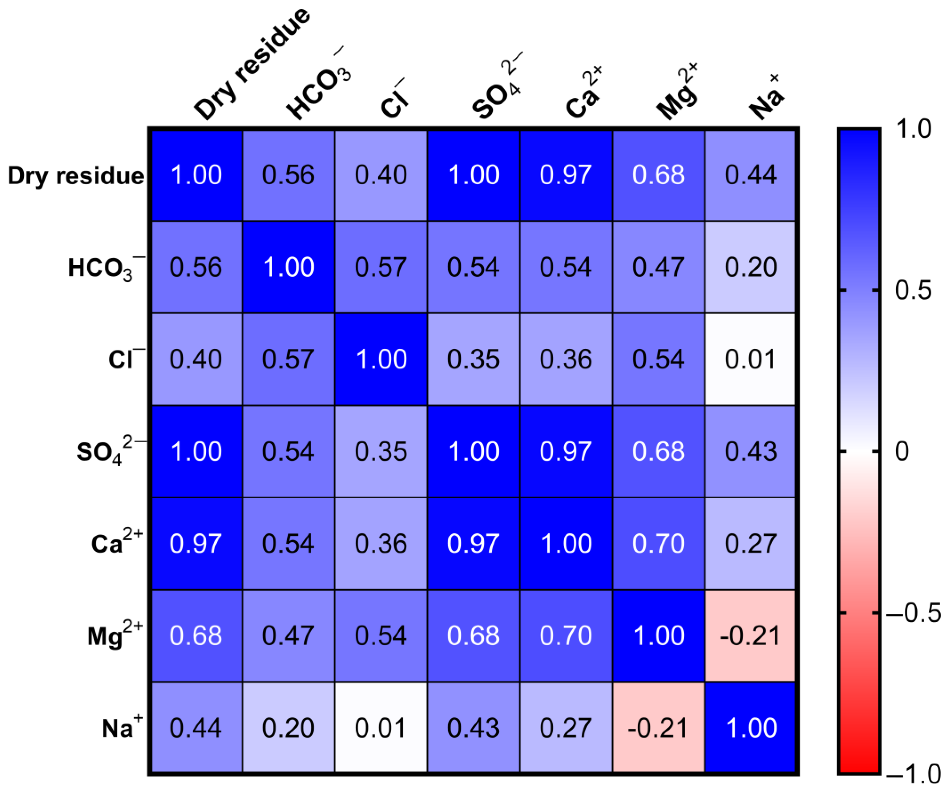
| Soil Section | Depth, cm | Horizon | Dry Residue,% | pH | CaCO3 | НСО3− | Cl− | SО42− | Ca2+ | Mg2+ | Na+ |
|---|---|---|---|---|---|---|---|---|---|---|---|
| % | |||||||||||
| 1 | 0–37 | PJ | 1.24 | 7.10 | 4.46 | 0.018 | 0.016 | 0.840 | 0.240 | 0.025 | 0.055 |
| 37–69 | BCAmc | 1.28 | 7.12 | 2.65 | 0.021 | 0.016 | 0.888 | 0.230 | 0.025 | 0.132 | |
| 69–87 | BCAnc | 1.19 | 7.15 | 2.52 | 0.015 | 0.023 | 0.792 | 0.234 | 0.015 | 0.103 | |
| 94–128 | Cca | 1.24 | 7.20 | 4.35 | 0.012 | 0.016 | 0.768 | 0.206 | 0.025 | 0.099 | |
| 128–154 | Cca | 1.02 | 7.20 | 12.95 | 0.009 | 0.008 | 0.696 | 0.206 | 0.002 | 0.101 | |
| 155–210 | Cca | 0.30 | 7.25 | 18.29 | 0.018 | 0.017 | 0.144 | 0.029 | 0.002 | 0.043 | |
| 2 | 0–32 | PJ | 1.44 | 7.15 | 4.10 | 0.029 | 0.040 | 0.926 | 0.288 | 0.050 | 0.056 |
| 32–45 | BCAmc | 1.22 | 7.15 | 3.20 | 0.025 | 0.015 | 0.835 | 0.260 | 0.029 | 0.063 | |
| 45–110 | BCAnc | 1.19 | 7.15 | 3.40 | 0.022 | 0.009 | 0.800 | 0.260 | 0.023 | 0.054 | |
| 110–142 | Cca | 1.08 | 7.25 | 5.90 | 0.021 | 0.009 | 0.731 | 0.210 | 0.016 | 0.093 | |
| 142–192 | Cca | 1.16 | 7.20 | 11.80 | 0.018 | 0.012 | 0.794 | 0.254 | 0.018 | 0.069 | |
| 192–242 | Cca | 0.30 | 7.22 | 16.40 | 0.012 | 0.015 | 0.183 | 0.056 | 0.009 | 0.024 | |
| 242–270 | Cca | 0.71 | 7.50 | 16.95 | 0.013 | 0.009 | 0.481 | 0.138 | 0.029 | 0.022 | |
| 3 | 0–30 | PJ | 1.35 | 7.20 | 1.25 | 0.025 | 0.026 | 0.904 | 0.295 | 0.047 | 0.030 |
| 30–44 | BCA | 1.24 | 7.30 | 2.30 | 0.015 | 0.018 | 0.848 | 0.272 | 0.042 | 0.030 | |
| 44–90 | BCA | 1.20 | 7.30 | 2.45 | 0.015 | 0.018 | 0.804 | 0.264 | 0.039 | 0.025 | |
| 90–136 | Cca | 1.10 | 7.35 | 5.36 | 0.017 | 0.016 | 0.748 | 0.252 | 0.027 | 0.035 | |
| 136–174 | Cca | 1.12 | 7.50 | 8.80 | 0.018 | 0.013 | 0.752 | 0.248 | 0.023 | 0.046 | |
| 174–196 | Cca | 0.32 | 7.80 | 8.82 | 0.012 | 0.012 | 0.201 | 0.064 | 0.006 | 0.023 | |
| 0–36 | PJ | 0.59 | 7.20 | 2.15 | 0.010 | 0.010 | 0.386 | 0.134 | 0.011 | 0.021 | |
| 36–70 | BCA | 0.62 | 7.25 | 2.56 | 0.012 | 0.013 | 0.408 | 0.142 | 0.013 | 0.022 | |
| 70–104 | Cca | 0.82 | 7.30 | 2.85 | 0.014 | 0.016 | 0.539 | 0.180 | 0.021 | 0.028 | |
| 104–136 | Cca | 1.24 | 7.50 | 3.40 | 0.015 | 0.016 | 0.842 | 0.256 | 0.050 | 0.031 | |
| 136–171 | Cca | 1.07 | 7.8 | 5.60 | 0.015 | 0.014 | 0.736 | 0.216 | 0.047 | 0.030 | |
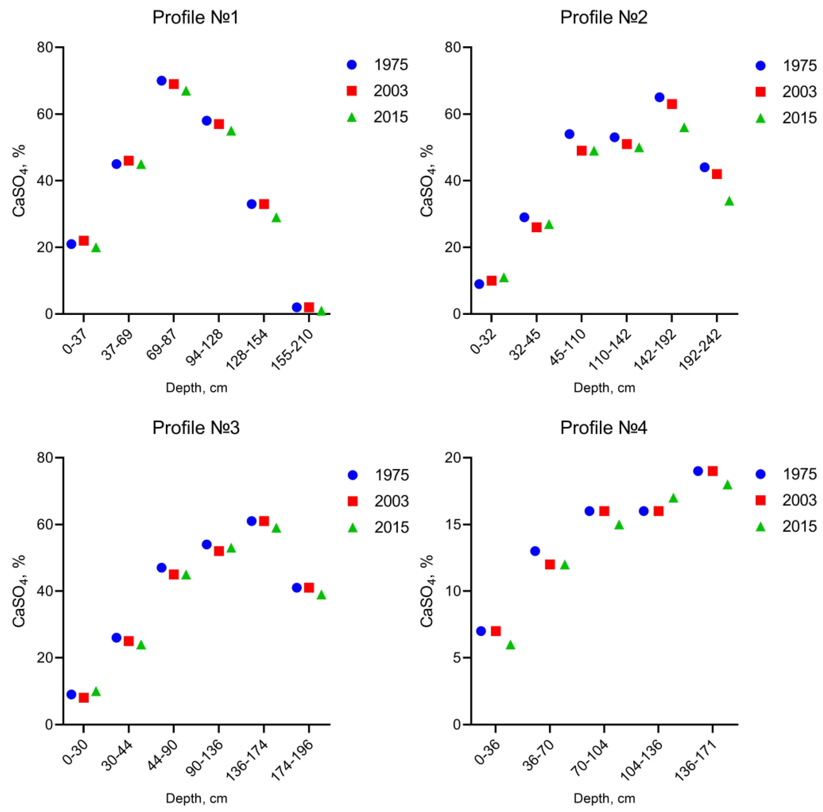
| Soil Section | Depth | CaSO4, % | ||
|---|---|---|---|---|
| 1975 | 2003 | 2015 | ||
| 1 | 0–37 | 21 | 22 | 20 |
| 37–69 | 45 | 46 | 45 | |
| 69–87 | 70 | 69 | 67 | |
| 94–128 | 58 | 57 | 55 | |
| 128–154 | 33 | 33 | 29 | |
| 155–210 | 2 | 2 | 1 | |
| 2 | 0–32 | 9 | 10 | 11 |
| 32–45 | 29 | 26 | 27 | |
| 45–110 | 54 | 49 | 49 | |
| 110–142 | 53 | 51 | 50 | |
| 142–192 | 65 | 63 | 56 | |
| 192–242 | 44 | 42 | 34 | |
| 3 | 0–30 | 9 | 8 | 10 |
| 30–44 | 26 | 25 | 24 | |
| 44–90 | 47 | 45 | 45 | |
| 90–136 | 54 | 52 | 53 | |
| 136–174 | 61 | 61 | 59 | |
| 174–196 | 41 | 41 | 39 | |
| 4 | 0–36 | 7 | 7 | 6 |
| 36–70 | 13 | 12 | 12 | |
| 70–104 | 16 | 16 | 15 | |
| 104–136 | 16 | 16 | 17 | |
| 136–171 | 19 | 19 | 18 | |
Disclaimer/Publisher’s Note: The statements, opinions and data contained in all publications are solely those of the individual author(s) and contributor(s) and not of MDPI and/or the editor(s). MDPI and/or the editor(s) disclaim responsibility for any injury to people or property resulting from any ideas, methods, instructions or products referred to in the content. |
© 2023 by the authors. Licensee MDPI, Basel, Switzerland. This article is an open access article distributed under the terms and conditions of the Creative Commons Attribution (CC BY) license (https://creativecommons.org/licenses/by/4.0/).
Share and Cite
Abakumov, E.; Yuldashev, G.; Mirzayev, U.; Isagaliev, M.; Sotiboldieva, G.; Makhramhujaev, S.; Mamajonov, I.; Azimov, Z.; Sulaymonov, O.; Askarov, K.; et al. The Current State of Irrigated Soils in the Central Fergana Desert under the Effect of Anthropogenic Factors. Geosciences 2023, 13, 90. https://doi.org/10.3390/geosciences13030090
Abakumov E, Yuldashev G, Mirzayev U, Isagaliev M, Sotiboldieva G, Makhramhujaev S, Mamajonov I, Azimov Z, Sulaymonov O, Askarov K, et al. The Current State of Irrigated Soils in the Central Fergana Desert under the Effect of Anthropogenic Factors. Geosciences. 2023; 13(3):90. https://doi.org/10.3390/geosciences13030090
Chicago/Turabian StyleAbakumov, Evgeny, Gulomjon Yuldashev, Ulugbek Mirzayev, Murodjon Isagaliev, Guzalkhon Sotiboldieva, Sultonkhuja Makhramhujaev, Inomjon Mamajonov, Zikrjon Azimov, Omonjon Sulaymonov, Khasanboy Askarov, and et al. 2023. "The Current State of Irrigated Soils in the Central Fergana Desert under the Effect of Anthropogenic Factors" Geosciences 13, no. 3: 90. https://doi.org/10.3390/geosciences13030090