

Risk-Reduction, Coping, and Adaptation to Flood Hazards in Manitoba, Canada: Evidence from Communities in the Red River Valley


1
Natural Resources Institute, University of Manitoba, Winnipeg, MB R3T 2M6, Canada
2
Department of Environment and Geography, University of Manitoba, Winnipeg, MB R3T 2M6, Canada
*
Author to whom correspondence should be addressed.
Geosciences 2023, 13(3), 88; https://doi.org/10.3390/geosciences13030088
Submission received: 27 February 2023
/
Revised: 15 March 2023
/
Accepted: 16 March 2023
/
Published: 18 March 2023
(This article belongs to the Section Natural Hazards)
Abstract
:In general, much is known about patterns relating to flood risk reduction, coping, and adaptation in various types of communities; however, knowledge of their drivers—which are critical for building community resilience to natural hazards—is limited. The present study investigates the influencing factors of coping and adaptation measures vis-a-vis flood hazards at the community level and examines their interrelationships. This work employs a “case study” approach and analyzes two towns—St. Adolphe and Ste. Agathe—in the Red River Valley in the province of Manitoba, Canada. Data collection consisted of in-depth interviews with key informants and obtaining oral histories from the locals, along with an examination of secondary official records and documents. The results revealed that the major drivers of local-level coping and adaptation include functioning partnerships among stakeholders, strong institutional structures that facilitate interactive learning, knowledge co-production, resources sharing, communication and information sharing, and infrastructure supports. It was observed that an institutional atmosphere conducive to spontaneous network development yields diverse coping and adaptation strategies. To improve the outcomes of coping and adaptation measures, close collaboration between community-based groups and formal and quasi-formal institutions, and transparency in decision-making processes are vital.
Keywords:
flood hazard; water level; disaster; emergency; risk reduction; coping; adaptation; partnerships; institutions1. Introduction
1.1. Background
Flood hazards occur when dry land becomes at risk of being geo-physically covered by water that has escaped or been released from the normal confines of an adjacent waterbody [1]. While the physical destruction wrought by floods is well-known, such events also have numerous negative social impacts, including coping capacity, access to health facilities, land tenure, transportation, housing, and socioeconomic status [2]. Globally, 44% of disasters are associated with floods. Indeed, from 1970 to 2019, flooding events accounted for 31% of the total global economic losses incurred by disasters [3]. Given the immense proportion of global disaster-induced losses caused by floods, flood risk reduction is a critical area of research and analysis in disaster management.
Over the years, there have been several shifts in international approaches to disaster management. Upon recognizing that institutional efforts to reduce disaster losses had largely failed, because they lacked a critical assessment of risk, the United Nations (UN) declared the period between 1990 and 1999 to be the International Decade for Natural Disaster Reduction (IDNDR). Key components of the IDNDR included the initiation of coordination among national-level disaster management efforts, as well as the promotion of risk awareness and the facilitation of institutional development. Furthermore, the IDNDR advocated for the development and implementation of scientific and engineering initiatives aimed at reducing fatalities and property losses from natural disasters. These actions subsequently led to the creation of the United Nations International Strategy for Risk Reduction (UNISDR).
Although the UNISDR did not produce any legally binding treaties with targets or potential repercussions for non-compliance, it did introduce the concept of disaster risk reduction (DRR) on the international stage [4]. The UN defines Disaster Risk Reduction (DRR) as,
the systematic development and application of policies, strategies and practices to minimise vulnerabilities, hazards and the unfolding of disaster impacts throughout a society, in the broad context of sustainable development.[5]
In 2005, 168 countries joined the Hyogo Framework for Action (HFA), which served as a global blueprint that member countries could use to guide their DRR efforts and reduce disaster-related losses by 2015 [4]. The HFA provided member nations with guiding principles, priorities for action, and practical means by which vulnerable communities could build disaster resilience [6]. However, at a summit in Sendai, Japan, in 2015, the 187 attending nations concluded that the HFA did not adequately address the increased vulnerability and exposure of communities to disasters, ultimately leading them to adopt the Sendai Framework for Disaster Risk Reduction (SFDRR) 2015–2030. The signatory nations agreed that DRR must address existing challenges and prepare for future disasters. As such, DRR focuses on three key areas: monitoring, assessing, and understanding disaster risk and sharing information; strengthening disaster risk governance and coordination across relevant institutions and sectors; and cultivating meaningful participation by relevant stakeholders [7].
In disaster management, the terms, “coping” and “adaptation”, are used interchangeably, but also convey separate meanings. Jabeen et al. [8] note that, in disaster studies, “coping strategies” and “adaptation strategies” are roughly synonymous within the context of climate change. However, while “coping” refers to a set of immediate and short-term measures or ex-post actions [9,10], “adaptation” measures typically involve more deliberate actions (ex-ante) [11]. According to Parsons et al. [12], coping with natural hazards is the process by which individuals or organizations utilize available resources, skills, and opportunities to address adverse effects that may result from a disaster. Furthermore, Lei et al. [13] note that adapting to disaster shocks involves mitigating harm and taking advantage of beneficial opportunities through learning, with the goal of harmonizing human actions with natural hazards, rather than attempting to control nature. Coping and adaptation measures consist of formal (e.g., market and public interventions) and informal instruments (e.g., individual, household, or community-based actions) [14], and are shaped by antecedent conditions [15]. In the context of the Red River Valley, we argue that coping and adaptation mainly involve adjusting to internal and external shocks and stresses. In this study, coping and adaptation processes are predominantly considered as separate processes (also see Azad et al. [16]); however, since there is conceptual overlap between coping and adaptation measures, we analyze these terms together as well as interchangeably in some sections.
We argue that certain drivers prompt the implementation of coping and adaptation measures in response to natural disasters such as floods. Identifying and analyzing the drivers of local-level coping and adaptation measures can potentially lead to the formulation of flood management policies that will enable successful and ongoing flood risk reduction. There is a large and robust body of literature on flood risk reduction and specific coping and adaptation strategies, including context-based approaches. For example, Parsons et al. [12] introduced a hierarchical Australian Natural Disaster Resilience Index based on coping and adaptive capacities that highlights the potential for disaster resilience. Investigating communities in France and Germany, Bubeck et al. [17] found that socioeconomic characteristics alone are inadequate for flood-coping appraisal; rather, the quality of such appraisals is also positively correlated with observational learning from the social environment. Elsewhere, Bloemen et al.’s [18] study of communities the United Kingdom and the Netherlands revealed that, in long-term flood management planning, an adaptation pathways approach is effective in advancing decision-making processes and increasing awareness. However, it is notable that limited effort has been devoted to understanding the multifaceted and interrelated drivers of coping and adaptation measures at the local level. In this study, we consider the drivers of coping and adaptation strategies as the primary factors that influence or motivate changes to, and the development of, new flood management measures when conventional [or maybe ‘previous’] measures become obsolete.
This study investigates the patterns and the drivers of coping and adaptation in local-level flood management strategies in the province of Manitoba, Canada. Specifically, this work has three key objectives: (i) to identify institutional coping and adaptation measures at the community level; (ii) to examine the influencing factors of coping and adaptation measures; and (iii) to identify coping and adaptation challenges for future floods.
1.2. Conceptual Considerations
The development of coping and adaptation strategies is often spontaneous and largely reactive. Additionally, the factors that drive such changes are contextual; that is, all factors may not influence coping and adaptation simultaneously. Furthermore, the drivers of coping and adaptation measures are generally interrelated and influence one another in a complex, dynamic manner when motivating changes in flood management activities. To understand what drives coping and adaptation to floods, it is necessary to examine the psychological underpinnings of the related behavioural patterns, including the decision-making processes [19]. Erdlenbruch and Bonté [20] note that unanswered questions relating to local-level cases include how long communities maintain adaptation measures, and how rapidly the measures are disseminated within the community. In the context of flood management, identifying the factors that drive coping and adaptation is essential in understanding how coping and adaptation measures are introduced and accepted or rejected by the community and institutional representatives. Additionally, determining how these factors drive changes in flood management is also important.
The unpredictability of nature-induced disaster shocks such as floods, necessitates management strategies to enhance adaptative capacity and the ability to live with floods. Here, adaptive capacity is defined as the ability of a system to plan and prepare for stress and adjust to it as it affects vulnerability through the modulation of exposure and sensitivity [21]. Choudhury and Haque [22] argue that the concept of adaptive capacity is central to disaster vulnerability and resilience, and that it has profound implications for disaster risk reduction. In terms of resilience, adaptive capacity is associated with coping and adaptation strategies, wherein it is a human attribute and a precondition for resilience [23]. To understand the factors that influence how vulnerable communities cope with and adapt to floods, it is necessary to draw on insights from local community-level flood management, institutional contributions, and governance strategies.
In this study, we draw upon Erdlenbruch and Bonté’s [20] Empirical Decision Model to formulate a framework that explains the interconnectedness between drivers of coping and adaptation to disasters at the local level. We refer to this framework as the Local Coping and Adaptation to Disasters (LCAD) framework (Figure 1). The LCAD framework illustrates the pathways through which different drivers influence coping and adaptation measures in local-level flood management, and how their interconnectedness and interdependence results in a DRR outcome.
Erdlenbruch and Bonté [20] drew upon the Protection Motivation Theory (PMT) to formulate an agent-based model that simulates the adoption of individual adaptation measures and enables an evaluation of the efficiency of communication policies. Their model focuses on two complementary elements of risk perception: threat appraisal and coping appraisal. According to the PMT, perceived benefits can temper threat appraisal. For example, the Dutch government took action to invest in flood-protection infrastructure, as it recognized the clear benefits of implementing flood risk-reduction measures. Notably, the Dutch government adopted a participatory approach by collaborating with the Consortium Grensmaas to implement these measures, and resulting in a network of knowledgeable governmental authorities and citizens [24]. Similarly, in Germany, threat appraisal led to proactive flood risk reduction, which included steps to implement the Floods Directives set forth by the European Union (EU). The Flood Directives require EU member states to identify, map, and manage flood risk and adopt adaptive legislation [25].
In our LCAD framework, social values, collective efforts, and original management strategy are conceptualized as sources of drivers (Figure 1, top box). The short-term flood disaster coping drivers are primarily influenced by the level of knowledge and information, capacity to mitigate impact, conformity, sociocultural value, beliefs, and the locus of control (Figure 1, boxes on left side). At the household and community level, drivers of coping and adaptation are unique in nature. For example, residents in the United Kingdom routinely adopt actions that are small, low-cost, low-tech, intuitive, and quick. Such coping and adaptation measures include making different dietary and/or clothing choices, and opening or closing windows. Conversely, long-term actions include relocating tangible goods to locations above flood level. To do their part to be prepared, many households also subscribe to the environment agency’s flood warning service. Additionally, most households also purchase insurance to safeguard themselves from catastrophic financial impact from flooding [26].
Belliveau et al. [27] revealed that crop producers in the Okanagan Valley of British Columbia, Canada, cope and adapt to flooding based on the availability of resources and technology, as well as access to government programs. In Victoria, Australia, Wilby and Keenan [28] identified several factors influencing adaptation measures at the community level, including routine monitoring, flood forecasting, data exchange, bridging organizations, contingency planning for disasters, insurance, and legal incentives to reduce vulnerability. In another study, Noll et al. [29] discovered that, in the United States, measures taken in the past significantly influence present and future coping and adaptation measures. In addition to threat appraisal and positive results from experience, coping and adaptation measures also depend on a household’s existing adaptative capacity. In Ingham, a rural town in Queensland, Australia, community coping and adaptation actions are predominantly driven by the desire to rely on government initiatives as little as possible [30].
Social motivation can also play a major role in coping and adaption processes. As an example, in towns in England and Wales, Lo and Chan [31] discovered that when community members observed others adopting coping and adaptation measures they were motivated to do likewise. The community’s social network provided the necessary platform for learning. In addition, coping and adaptation is also driven by the perceived severity of flood damage, which is created through communicating information about risk. Information that creates fear and a sense of uncertainty is less likely than previously thought to be effective in driving such actions.
During and after a 2006 storm surge in Tsawwassen, British Columbia, Canada, coping and adaptation practices by members of the community were heavily influenced by the actions and opinions of family, friends, and neighbours, as well as the perceived benefits of different strategies, financial support, perception of other hazards, and government interventions [32]. Similarly, in a case study in Wagga Wagga and Kempsey, New South Wales, Australia, Khalili et al. [33] concluded that the indicators of a resilient community—the end results of coping and adaptive measures—were community, education, community participation, social support, learning, trust, exchange information, and shared information.
A variety of activities are integral to coping and adapting to floods (Figure 1, left side box), which may involve institutional measures and arrangements to help local communities. For example, in their study of towns in Alberta, Canada, Hayes et al. [34] suggested that, depending on the town’s capacity, the provincial government will award contracts to outside response organizations to help cope with floods. Furthermore, actions arising from people’s belief systems and faith play an important role in coping and adaptation, especially in uniting community members in times of crises. Gianisa and Le De [35] observed that, after the 2009 earthquake in Padang, Indonesia, religious beliefs and practices played a key role in helping community members bond with one another and helped them successfully cope with the effects of the disaster.
Reaction to an incident can also be a major driver of coping and adaptation measures at the institutional level. For example, in the Netherlands, extreme discharges from the Rhine River in 1995 forced the evacuation of 200,000 floodplain inhabitants. The Dutch government realized that past practice of increasing height of the dikes was no longer adaptive in the face of future climate change. In 2006 they launched the “Room for the River” program, which initiated the development of multiple flood mitigation measures along the rivers to prevent flooding [36]. With multiple measures, this program indirectly reduces water levels. Such measures include deepening some channels, water storage where possible, dike relocations back from the existing channel to widen the river, secondary channels, removing flood plain deposits, lowering locks during flooding and reinforcing dikes. Garrelts and Lange [37] found that, in Germany, the public’s perception of risk was not commensurate with the uncertainties caused by climate change, especially with respect to floods. This incongruence motivated the regional and federal governments to embark on public-awareness campaigns stressing that the flood risk would persist, and that flood-protection measures guaranteed only limited safety.
In this paper, we argue that coping and adaptation are mobilized by learning-by-doing and initiatives at the community and institutional levels. A thorough understanding of local disaster risks and the underlying causes of the adverse impacts of flood disasters is indispensable in learning to live with floods, enhancing adaptive capacity, and building social, economic, and ecological resilience.
1.3. Flood Vulnerability and Risk-Reduction Measures in the Red River Valley, Manitoba
1.3.1. Geophysical Vulnerability
The geophysical vulnerability of a place is directly related to its physical exposure to natural hazards, particularly their magnitude, duration, and frequency [38]. As the flood-forming conditions and geophysical vulnerability of the Red River Valley in Manitoba, Canada, have been discussed in detail in an earlier publication [39], only a brief overview is provided herein. Three broad categories of flood-forming conditions prevail in the Red River Valley: (i) geological and physiographic conditions; (ii) hydrometeorological conditions; and (iii) human/societal factors.
The southern part of the Province of Manitoba was formerly the floor of glacial Lake Agassiz, which resulted in its current status as a basin with a low-lying topography. Due to the flatness of the region, water can remain present for very long periods, which frequently results in significant surface flooding. The physiographic orientation of the Red River—it flows south-to-north (from North Dakota, USA, to Hudson Bay) with a gradual gradient decline in topography—further contributes to flooding as ice often remains on the northern stretch of the river as spring meltwater flows northwards. Additionally, isostatic rebound is causing elevation to rise faster in northern Manitoba, increasing flood risk in the south. Additional hydrometerological conditions include large spring snowstorms caused by low pressure systems arising in the southwestern USA.
Apart from physical landscape and hydrometeorological causes, vulnerability to flooding can also be created by human-induced economic development. For example, in the Red River Basin, 98% of wetlands have been converted into farmland since European agricultural activities began in Manitoba [40]. In addition to the region’s flat topography and loss of wetlands, tilling practices and strategies for rapid surface drainage have also increased the magnitude of flooding, as these practices increase surface runoff during heavy precipitation and during spring melt [29].
Population growth also contributes to an increase in the magnitude and frequency of flooding, as it requires the conversion of open spaces into paved areas, which in turn creates more runoff. This is a significant factor, as estimates suggest that the population of the Red River Valley has increased from about 265,000 in 1931 to over 750,000 in 2016 [41]. Furthermore, mitigation measures to protect infrastructure divert water into rivers and streams, which can lead to rapid increases in water levels and currents after spring melts and during summer storms [29]. Overall, the growing population living in the Red River Valley is exposed to more frequent and extreme flooding, rendering them very vulnerable to loss and damages with respect to property, livestock, and infrastructure.
1.3.2. Flood History in the Red River Valley
The notable floods of the 19th and 20th centuries in the Red River Valley include the flood of 1826, which had a return period of 500 years, and high-magnitude floods in 1852, 1904, 1916, 1948, 1950, 1979, 1997, 2009, and 2011. As flood memory plays a critical role in risk reduction and adaptation measures, it is important to analyse the historical patterns and experience of floods using archival data sources [42,43]. Indeed, the communities in Manitoba’s Red River Valley have over a century of experience dealing with catastrophic floods, with the earliest instances being recorded by fur traders in 1793 and 1798 [44,45]. Comparisons of major flood years since the 1826 flood in relation to natural spring discharges and natural peak stages measured at James Avenue, Winnipeg, can be made from data presented in Table 1. The 1950 flood occurred between April-June and had a devastating impact on the capital city of Winnipeg, as more than 100,000 residents were forced to evacuate from their homes.
The 1997 flood, dubbed “The Flood of the Century,” was so severe that it caused other rivers to swell, which affected numerous communities along the Red River Valley. During this flood, the water level in the Red River rose by as much as 7.5 m, which reached its peak in early May–the highest peak since 1950 flood (see Figure 2)–with estimates suggesting that it may have reached up to 10.5 m without flood-control infrastructure. The Flood of the Century occurred between April-May of 1997, and was the most severe flooding event since 1852. This flood was caused by a combination of several meteorological conditions, particularly heavy rains in the autumn of 1996, which saturated the soil with moisture, and four blizzards throughout the winter and spring of 1997. In the spring, the heavy snowfall of the winter began to melt gradually, but a “Colorado Low” from the United States brought a massive snowfall at the beginning of April. By mid-April, the snow started melting again, but the runoff was too much for the water table to handle, thus yielding a once-in-a-century flooding event. The federal government responded by sending over 7000 military personnel to help with the flood effort over a 36-day period, while 25,450 people were forced to evacuate from the valley and relocate [29].
After the Flood of the Century, the most notable floods in the Valley were the floods of 2009 and 2011 [46]. One major cause of the 2009 flood was a heavy rainstorm that occurred in the first week of November 2008. In addition, an exceptionally cold winter restricted the percolation of spring runoff, while above-average snowpack thwarted runoff in the USA portion of the watershed. Thus, blocked drainage due to unusual ice conditions and disrupted surface runoff resulted in high river water levels. Similarly, in late 2010, precipitation reached a 15-year high when a super-charged “weather bomb” brought 50 to 100 mm of snow and rain. These high levels of precipitation were exacerbated by unusually cold spring temperatures, which disrupted snowmelt and made it difficult to predict flooding. The final factor leading to the 2011 flood occurred in April, when ice jamming along the Red River caused water levels to rise and flood the Red River Valley.
Since the 1950 flood, most provincial adaptation measures in Manitoba, including boulevard diking, diversions, the Red River Floodway, the Portage Diversion, and the Shellmouth Dam, have been event-driven [47]. However, climate variability may increase annual discharges and shift the start of flood season and peak occurrence in the river basins [48], which will potentially render current coping and adaptation measures less efficient. Wang et al. [49] argue that Manitoba should implement adaptation plans designed to cope with the adverse impacts and associated extremes of climate change, and to adapt to the unpredictable nature of floods in this province.
1.3.3. Flood Risk-Reduction Measures
Flood risk reduction became a priority for the Manitoba government following the 1950 flood’s devastating impact on the capital city of Winnipeg. As an adaptive measure after the 1950 flood, the federal and the provincial governments jointly established a Royal Commission tasked with conducting a cost-benefit analysis assessing the potential damage of future floods compared to potential flood prevention and mitigation alternatives. The Royal Commission submitted its recommendations in 1958, which initiated a major project entailing the construction of floodway around Winnipeg. The floodway project had four components: (a) the inlet channel, (b) the floodway channel, (c) the outlet structure, and (d) the east and west dikes. The then-$63 million dollar project was cost-shared, with the federal government contributing $37 million.
In subsequent years, the Government of Manitoba drew upon the lessons learned from the floods of 1950 and 1966 and negotiated with the federal government to embark on a cost-shared project involving the development of permanent dikes along the Red River Valley. This permanent diking scheme included both the diking of towns and the protection of farmsteads by either ring dikes or elevating farm buildings by raising the foundations. These flood risk-reduction measures were upgraded to a 100-year flood level based on the lessons learned from the flood of 1979. The flood of 1997, the largest flood in the Red River Valley since 1852, was a reminder that flood risk-reduction through coping and adaptation processes is an interminable endeavour [50].
The catastrophic 1997 flood revealed that flood-control structures and institutional interventions were not sufficient for protecting the valley’s inhabitants and their property due to lack of communication and understanding between institutions. Additionally, a reluctance to implement up-to-date regulations and limited public participation in the decision-making process during the flood were other key elements that rendered organizational preparedness and mobilization to cope with the flood emergency futile [50].
Concurring with Haque [50], Stewart and Rashid [51] suggest that, even a decade after the 1997 flood, a lack of risk communication, information sharing, bottom-up activities, and partnership development persists in the Red River Valley. Although structural mitigation measures such as the Red River Floodway and community dikes can reduce floodwater flow, thus limiting flood risk to some extent, flood risk and vulnerability persist due to the occupancy of flood-prone zones, as well as external pressures created by regional floodplain policies and procedures affecting social vulnerability.
2. Materials and Methods
2.1. Study Area
The field study portion of this research was conducted in the communities of St. Adolphe and Ste. Agathe, which are located in the Rural Municipality (RM) of Ritchot, Manitoba. These communities were primarily selected due to their high vulnerability to floods as a result of their geographic location (Figure 3), their experiences with flooding in recent decades, and the RM of Ritchot’s willingness to participate in the research. Additionally, these communities were also selected for their geographical accessibility, and their proximity to four rivers: the Red River, the Rat River, the LaSalle River, and the Seine River. The Red River is the largest of the four, flowing north from the United States, past Ste. Agathe and St. Adolphe, through the City of Winnipeg, and ultimately draining into Lake Winnipeg. All communications, interviews and analysis involving individuals in this study was conducted following Research Ethics Approval # HE2021-0126.
Limited research has been conducted on the patterns of flood preparedness, emergency response and recovery, and drivers of coping and adaptation in this geographical area. Thus, the understudied nature of this region presents an opportunity, as the selected communities have the potential to serve as exemplars of micro-level flood management in rural Canada.
The flood characteristics in Manitoba are unique and profoundly influenced by the geography of the Red River Valley. The flow of the Red River is erratic and highly variable, ranging from periods of virtually no flow to extremely high flows that create flood conditions. Moreover, the populations of St. Adolphe and Ste. Agathe are steadily growing, along with the number of businesses and industries, which means that the number of vulnerable people, properties, and businesses in this area is also growing.
The residents of St. Adolphe and Ste. Agathe primarily depend on farming and tertiary services for their livelihood, which are often affected in times of flooding. Data from the 2016 Census indicates that 48.9% of the population in St. Adolphe and 35.2% of the population in Ste. Agathe are either younger than 15 years of age or older than 65 years of age (i.e., the dependent population). In addition, women account for approximately half of the population in both communities [52].
2.2. Field Methods and Data Collection Procedures
For this study we applied the case study approach developed by Yin [53], as it provides in-depth descriptions of, and insights into, a process or phenomenon within a bounded system or setting [54,55]. In this research, the communities of St. Adolphe and Ste. Agathe were selected as the study area. The suitability of a “case study” approach has long been recognized in community-based flood disaster management research, as its inclusion of community members as a data source allows the study to capture the experiences of vulnerable populations and their resources [56].
After developing an in-depth understanding of the effectiveness of the existing flood management system and interpreting its current state, consultations with community members and officials from NGOs and local and provincial governments were conducted. Such discussions aimed to examine their understanding of patterns of flood preparedness, emergency and recovery measures, and the drivers of coping and adaptation strategies at the local level. To meet these objectives, a community-based research method was employed.
A 3-tier study design was formulated and implemented. Primary data were collected via three methods: (i) key informant interviews (KIIs), (ii) oral history interviews (OHIs); and (iii) document review. KIIs were selected as a data collection method because they focus on individuals with knowledge relating to a particular issue, thus enabling an in-depth investigation into that issue [57]. The insights gained from KIIs help to understand and explain the experiences and reasons behind various changes in social and political processes [58,59]. Although KIIs are place-based, it is possible for the informants to identify attitudes and issues that have also been recognized in other places [60]. The KIIs used questionnaires consisting of semi-structured questions and were conducted with a total of eight respondents from the two selected communities, including government officials engaged in flood management in the RM of Ritchot, provincial government personnel, and representatives from local NGOs. They interviews were conducted in person.
Data collection via oral histories was selected for use in this study because oral histories are comprised of local stories and reminiscences provided by community residents who have first-hand knowledge of the experiences contained therein [61]. OHIs are a collaborative, narrative-building process between the researcher and interviewee that involves spending a long period of time together [62]. OHIs emphasize the experiences of the individuals being interviewed [63]. To analyze the interviewees’ common experiences and variable perceptions, a total of seven selected oral history interviews were carried out in the two communities using questionnaires consisting of semi-structured questions.
Purposive and snowball sampling procedures were employed for the selection of participants [64]. Purposive sampling was used to identify participants who could provide specific information about a given topic, while snowball sampling was helpful in identifying key stakeholders who had experienced several floods and could therefore provide comprehensive insights [64].
In addition, document review was carried out by combining the steps developed by Sikder [65], and O’Leary [66], which are illustrated in Figure 4. A list of documents was prepared for analysis purposes using the following sources: (i) the University of Manitoba libraries; (ii) Google Scholar for research articles; (iii) annual reports and documents of NGOs involved in flood management in Manitoba; (iv) laws, by-laws, acts, and policy documents from the Government of Manitoba and EMO websites; (v) Public Safety Canada website; (vi) local and national newspapers; and (vii) government and NGO officials.
Project researchers checked the accessibility of the chosen documents and used pub-licly available ones for data collection. The authenticity and credibility of the documents were also assessed and verified by jointly analyzing them with the relevant participants. Furthermore, each document was analysed for potential bias, and consideration was given to all available sources to avoid prioritization. The method and reasons behind the production of the documents were explored to aid in their interpretation. Witting evi-dence (what the document was meant to impart) and unwitting evidence (everything else that can be gleaned from the document) were identified. All documents were rigorously reviewed, and meanings were interpreted to draw conclusions. The data in these docu-ments, which embodied the step-by-step processes of adaptation and risk reduction measures, were analyzed to determine their drivers.
Project researchers checked the accessibility of the chosen documents and used publicly available ones for data collection. The authenticity and credibility of the documents were also assessed and verified by jointly analyzing them with the relevant participants. Furthermore, each document was analysed for potential bias, and consideration was given to all available sources to avoid prioritization. The method and reasons behind the production of the documents were explored to aid in their interpretation. Witting evidence (what the document was meant to impart) and unwitting evidence (everything else that can be gleaned from the document) were identified. All documents were rigorously reviewed, and meanings were interpreted to draw conclusions. The data in these documents, which embodied the step-by-step processes of adaptation and risk reduction measures, were analyzed to determine their drivers.
3. Results
Empirical data suggest that local-level risk reduction, coping, and adaptation strategies to withstand flood losses in Manitoba, Canada, are not independent at the community and institutional levels. Rather, community- and institutional-level flood management measures are interdependent and integrated with each other. Overall, community members’ rely heavily on formal (different levels of governments and NGOs) and quasi-formal (community-based groups and organizations) institutions.
The coping and adaptation strategies discussed in this section have evolved over time, mostly based on previous flood experiences and shared learning. From our collected data, we identified three major areas where specific drivers influenced changes in flood management and instigated both spontaneous and intentional coping and adaptation measures. These areas are: (i) local community-level initiatives; (ii) interaction between governments, non-governmental organizations, and community members; and (iii) initiatives by non-profit organizations.
3.1. Community-Initiated Risk Reduction, Coping, and Adaptation Measures
We observed that community level initiatives were predominantly needs-based, especially when formal institutions failed to take flood-protection measures that aligned with the expectations of the community. These initiatives were undertaken at the individual level, collective level, and in communication with formal institutions. The identified local community-level coping and adaptation initiatives and their drivers are summarized in Table 2.
At the individual level, community members place sandbags around their properties after the release of the flood forecast to protect them from flood water. The community members’ initiatives involve a wide range of activities. For example, in Ste. Agathe, river erosion remained a persistent concern, despite protective measures to save adjacent land and properties. As such, the residents reached out to the municipality authority and the provincial government with the expectation of finding a solution. The provincial government commissioned a study and concluded that the riverbank could be stabilized at an expense of $8 million. However, such an expense was difficult to justify, as Ste. Agathe had only 500 inhabitants at the time. Subsequently, the community ordered trees from Indian Head, a forestation center in Saskatchewan, and planted them along the riverbank to fortify it against floodwater. In addition, during an emergency, community members, including student volunteers who are bussed in, work together to help affected residents sandbag their properties. Pumps were installed to remove water from the diked areas of the communities, which needed to be purchased and maintained by community members. As a risk-reduction measure, the residents established a list of people able to run the pumps and help with evacuation, if necessary. This group, known as the Essential Services, consists of people with expertise in running gas stations, working on machines, and making food. The rest of the community members were evacuated as conditions required.
If deemed insufficient, community people also became very vocal about the provincial government’s flood management strategies and held formal institutions accountable. For example, after the flood of 1997, a meeting was organized between residents of St. Adolphe and Ste. Agathe and the Premier of the Province at St. Boniface University. In this meeting, the community members in attendance demanded an explanation from the government for its actions during the preparedness and response phases.
3.2. Government-Institution-Led Strategies
Depending on the situation, the provincial government adopts coping and adaptation measures in collaboration with local governments, non-government organizations (NGOs), and local communities. The Department of Manitoba Transportation and Infrastructure is responsible for the provincial road network, provincial water control network and also for the operation of the Red River Floodway (through the Red River Floodway Authority) and the maintenance of all 18 dikes in the Red River Valley. Risk-reduction decisions follow a hierarchal bureaucratic structure and their associated processes which involves stakeholders at various stages of these processes. The Emergency Measures Organization (EMO) is the primary coordinating body for flood emergency response, collaborating with relevant departments.
Table 3 shows the coping and adaptation measures taken by the provincial government, their interaction with NGOs, and the drivers of such measures. In Manitoba, flood risk-reduction measures combine flood mitigation, preparedness, and response, with an emphasis on communication, proactive initiatives, reactive survival, and decision making. The provincial government recognized that meaningful communication among stakeholders is critical for effective disaster and emergency management. Despite the potential that information may be misinterpreted, the government is willing to take that risk because of the benefits such knowledge provides. According to one government official, spending time on communication and explanation minimized the risk of misinterpretation:
Communicating why mitigation activities are beneficial when you cannot see the result tomorrow is always difficult. Again, the information we provide to people is usually never sufficient because, by definition, it is a disaster where everybody is asking questions and saying they do not have enough information. But we always confirm the accuracy of the information we provide to people.
The Emergency Management Division of Manitoba Transportation and Infrastructure works through their Emergency Operations Center and ensures strong links to key partners across the Emergency Management System. Every municipality has a Municipal Emergency Coordinator, who is involved with the planning processes of the Emergency Operations Center. The Center provides flood management information in response to queries from the Emergency Coordinators. When expenditures exceed the resources of the Province, a “request for assistance” will be made to the Federal government.
For the Province, the EMO serves as the information hub where the provincial government can integrate information from stakeholders in schools, hospitals, and senior care homes for use in the event evacuation becomes necessary. The EMO relays information about the demand for and delivery of sandbags and any other service or resources provided by the government. The Provincial government has a liaison officer with expertise in flood management who maintains communications with chiefs of nearby First Nations communities. This allows the chiefs to contact the liaison officer directly in the event of an emergency, or they can reach out to Indigenous and Northern Affairs Canada (INAC).
During the 1997 flood, the provincial government collaborated with the Canadian Red Cross to get food vans out to flood-affected communities to provide residents with food and water. The provincial government also provided temporary offices within the communities where community members could go for information and guidance. Furthermore, the Province also arranged for boats to evacuate people living in remote areas or where road access was lost because of flooding.
When necessary, the Government of Manitoba contacts the federal government to activate the Disaster Financial Assistance (DFA) program, which is designed to provide disaster-affected community members with financial aid based on their needs. The provincial government also sends an adjuster to flood-damaged houses to determine if they are salvageable or need to be “written-off.” Based on the need assessment, a household could receive up to $100,000 in 1997.
The provincial government takes initiatives to educate community members with respect to developing compatible emergency plans, communicating during emergencies, setting up evacuation routes, establishing an Emergency Operation Center in the municipality, and the need to store adequate food, water, and power to last for 72 h.
In 2006, the Government of Manitoba partnered with the municipalities to initiate the Ice Jam Mitigation Program, wherein they brought in Amphibexes (ice cutting machines) to break up the ice on the river. The program expanded in 2011, when two more Amphibexes were added to the existing two. Recently, the government’s ice-cutting program was dissolved, and contractors are now hired to perform this work.
In 2009, the Government of Manitoba initiated the home buyout program, which allows the government to purchase homes that are vulnerable to floods and cannot be protected. Qualifying homes are those deemed to present harmful conditions for both the occupants and rescuers during a flood. The Province has also implemented a two-step application process for buying and building new houses outside of community ring dikes and in the Red River flood designated areas. For instance, new builds must adhere to flood-protection levels dictated by the Province. The two-step application requires builders to provide the municipality with a plan showing the proposed elevation of the house and to obtain a building permit.
In the past (~20 years ago), risk communication from the provincial government to local communities placed considerable emphasis on appropriate emergency response. However, in recent years, the focus has shifted more towards flood mitigation and preparedness. Indeed, with climate change and the unpredictable nature of floods, “building resilient communities” and “climate change adaptation” have been gaining more attention in risk communication and disaster management approaches by the federal and provincial governments.
3.3. Non-Governmental-Organization (NGO)-Led Strategies
In recent decades, changes in the wet and dry cycles due to climate change have become an additional concern with respect to flood and water management for non-profit and non-governmental organizations such as the Red River Basin Commission (RRBC) and the Watershed Districts. In 2022, after three consecutive dry years, snowfall, snowstorms, and rainfall broke decades-old records, which posed a serious flood threat in the event of a rapid (rather than gradual) spring thaw. However, even in dry cycles, farmers have become interested in water harvesting and water-retention projects, especially when water can be used with forages to feed cattle.
Non-profit organizations’ contributions to local-level coping and adaptation measures, along with their drivers, are shown in Table 4. The Watershed District working in the RM of Ritchot and the RRBC are the two major non-profit organizations involved in flood management in St. Adolphe and Ste. Agathe. Water-retention projects are the most prominent of the projects run by the Watershed District. For water-retention projects, water is stored on lands rented from landowners or farmers that cannot be used for cultivation, but are suitable as pastures. The stored water can absorb flood water-shocks and it buffers the floodwater waves to mitigate further damages. Without water-retention projects, farmlands might become inundated due to “bottleneck effects” in the drainage system, which can in turn put nearby houses and roads at risk. One professional with the Watershed District referred to this phenomenon as the “bathtub effect.” Since the cultivation of crops is more profitable than renting out lands for water-retention projects, farmers and landowners are generally reluctant to allocate their lands for such initiatives. However, the Watershed Districts authority has gradually been able to explain the long-term benefits of these projects to farmers and landowners. As a result, more farmers are now inclined to rent out their lands for a season to help minimize flood losses. As a coping and adaptation measure, the Watershed Districts tries to prioritize pastures for use as water-retention projects so that the grasses do not dry out and cattle can graze when the pastures are dry. For water-retention projects and flood management planning, a three-dimensional mapping system is necessary. The Watershed Districts advocated for the utilization of LiDAR (Light Detection and Ranging)—which is a method for the determination of ranges—data in flood management as an adaptation measure, as LiDAR can produce a digital 3-D representation of the topography of the Earth’s surface.
After successfully implementing the retention projects, the lands became more fertile and easier to cultivate after the water receded. However, according to an official with the Seine Rat Roseau Watershed District, flooding has become unpredictable due to climate change, and such uncertainty is affecting the benefits of water-retention projects. This official further shared that:
The Province currently only requires the Intensity-Duration-Frequency Runoff curve. But for water-retention projects implementation, we need an IDF curve that accommodates climate change. We are finding that seriously problematic.
To cope with flood water, the Watershed Districts use a berm (a flat strip of land, raised riverbank, or a terrace that borders a river or a canal) across low-lying lands with a culvert underneath. Culverts enable a consistent flow of water, which is known as a passive flow structure. The Watershed Districts also collaborate with the International Institute for Sustainable Development (IISD) in constructing hydrodynamic models, which are prepared by reading the surface and sub-surface waterflow with the high-water tables in place. The Watershed Districts also collaborate with Service Water Management Planning, where they are able to work with the engineering team. In March 2019, the provincial government initiated the Grow Trust to support watershed-based conservation initiatives. The Grow Trust is a $52 million trust, and the first of its kind in Canada.
The Red River Basin Commission (RRBC) plays a paramount role as a common platform for discussions relating to flood management and the preservation of stakeholders’ interests, irrespective of political inclination. The RRBC also works as a reliable entity that holds stakeholders together and provides a platform where stakeholders from Canada and the United States can participate in open discussion.
3.4. Challenges to Coping and Adaptation Strategies in Flood Management
The challenges to coping and adaptation strategies at the local level vary based on the context. The results of this study identified patterns in coping and adaptation measures regarding local-level flood management in St. Adolphe and Ste. Agathe, as well as several challenges for implementation, including: (i) inadequate support from government; (ii) recovery timespan during the restoration period; (iii) loss of flood memory and collective amnesia; (iv) lack of community-level preparedness; (v) disregard of emotional values; (vi) lack of transparency at the senior government levels; (vii) communication gaps; and (viii) private flood insurance coverage. These challenges are summarized in Table 5.
From Table 5, it is evident that a lack of communication is one of the major challenges in local-level flood management. For example, a growing dissatisfaction was observed among the RM respondents who felt the City of Winnipeg—Manitoba’s capital city—is prioritized in the Province’s flood management strategies. As one community member observed:
At the end of the day, all residents in the Red River Valley deserve an equal amount of protection for flood events, regardless of where they live in.
There is also concern about the misinterpretation of disseminated information. One government official commented that, in a risky environment, the more information the local community people receive, the more they think that they do not have enough information. Such perceptions can be very detrimental to the ability to work collaboratively.
One Watershed District official claimed that, although the watershed and protected areas are under the Department of Agriculture and Resources Development, the officials in that department responsible for funding Watershed District projects do not have relevant technical knowledge. As a result, these decision makers do not properly understand the local needs of the community and cannot appropriately allocate a yearly budget.
Local-level flood preparedness is influenced by the interplay between funding concerns, revenue generation, and the safety of the community. Many home buyers wish to purchase houses that are located near bodies of water. If a house needs to be elevated, such upgrades can cost upwards of $15,000 to $20,000, depending on the size of the house. This may discourage homebuyers from purchasing a house in municipalities with such regulations. Moreover, the costs of a large-magnitude flood fall under the DFA, which may potentially encourage people to purchase houses situated on low-lying land and lacking appropriate protective measures. Speaking about the rural municipalities, one provincial government official stated that:
They’re kind of put in a bit of the unfortunate spot of trying to balance those competing interests that they have. Some municipalities do a good job of saying, “this is your protection level, if you want to build here, you better protect to this level.” Others will say, “that’s not really our job. We don’t want to scare these guys off,” and they’re a little more permissive, and they will let things go. So that’s an interesting piece of the puzzle.
Faded memories of past floods contributes to a lack of preparedness. Communities tend not to prioritize or consider issues that they do not frequently encounter, leading to a sense of overwhelming shock when a major flood event occurs. A member of the St. Adolphe community stated that:
Once the flood is gone and you’re back into your house, and after four or five years you’re back in naturally, almost where you were before. People just move on with their lives. I certainly did. And then you feel very comforted with some of the post-flood mitigation work.
In terms of coping strategies during the emergency response phase of the 1997 flood, authority in the RM of Ritchot was concentrated in the hands of a councillor who was originally from Ontario and who possessed very little local knowledge. A community member from Ste. Agathe mentioned that:
The Province had no information system, everything was manual. So, recovery was tedious at best. From a modeling perspective, in Ste. Agathe, we were told that the water level was going to be 776.5 feet above sea level. And that level was given to us probably 10 days prior to the water arriving. So, the modeling was okay. The direction to mitigate against the incoming water was where we failed as a province and as a local community. The water came over the highway by six inches, it wouldn’t have been that complicated to dike the highway, but they did nothing with the highway.
4. Discussion
The findings of this study revealed multiple drivers of coping and adaptation strategies. To identify the drivers, we analyzed the patterns of coping and adaptation measures in the communities St. Adolphe and Ste. Agathe, Manitoba, Canada. The identified drivers of coping and adaptation strategies in these two communities were limited to local community initiatives, interaction among different levels of government, non-governmental organizations, and initiatives by non-profit organizations. Significantly, the findings showed that these drivers are not independent; rather, they are interdependent and intertwined.
As Olausson and Nyhlen [67] have suggested, networks formed spontaneously by stakeholders, rather than by the government, can engender diversified solutions in terms of focus, organization, and decision-making. After the 1997 “Flood of the Century,” spontaneous networks were built in local communities in the Red River Valley. However, as memories of the flood faded, these networks began to dissolve, consequently increasing the region’s vulnerability. This finding is consistent with Lopez et al.’s [68] observation that as a component of adaptation measures, social preparedness is strongly affected by human behavioral traits such as risk awareness, recency of flood experience, trust in the authorities, and interactions among social groups.
Our findings further revealed that the community members of St. Adolphe and Ste. Agathe have trust in the structural measures taken by the provincial government and, as such, do not perceive a risk of devastating flooding. Therefore, the residents of these communities were generally reluctant to take any coping and adaptation measures, especially after the construction of the community dikes. However, vulnerable residents did take steps to elevate their houses and other properties as mandated by the local municipal authority. In contrast, Porter et al. [26] found that households in the United Kingdom routinely adopted low-cost, low-tech, intuitive, and quick actions that included changing their diets and clothing and purchasing insurance. Similarly, in the rural town of Ingham in Queensland, Australia, the major driver of community-level coping and adaptation measures was the desire to rely on governmental measures as little as possible [30]. Even in the presence of reliable government initiatives (e.g., structural measures), such proactive measures would encourage coping and adaptation at the community level and decrease pressure on the capacity of local and provincial governments.
Our research also revealed that, although the residents of these two communities were concerned about climate change, they did not take any adaptive measures to counter climate-induced uncertainties. This contrasts with the community members of the Okanagan Valley, British Columbia, Canada, whose coping and adaptation measures to withstand flood losses were driven by the changing climatic conditions and a motivation to be proactive [27].
Flood adaptation measures worldwide involve a wide range of specific activities that are driven by multiple factors. For example, in Victoria, Australia, Wilby and Keenan [28] found that the enabling factors of adaptation measures included routine monitoring, flood forecasting, data exchange, institutional reform, bridging organizations, contingency planning for disasters, insurance, and legal incentives. In Wagga Wagga and Kempsey, New South Wales, Australia, coping and adaptation were also driven by learning, the exchange of information, and shared information [33]. In St. Adolphe and Ste. Agathe, coping and adaptation measures at the community level were dependent on similar factors, where the community members’ experience indicated that sometimes flood forecasts were incorrect. Although the provincial government took some measures to interact with the residents of these communities, the community members felt these measures were insufficient.
Coping and adaptation to flood disasters are also profoundly influenced by functioning partnerships among stakeholders. Haque and Etkin [69] observed that, along with experience of natural hazards and structural approaches, successful recovery and coping with disasters requires functioning partnerships among stakeholders within the formal organizational structure and involving them with interactive learning, the co-production of knowledge, resource sharing, and a collective decision-making culture. Here, stakeholders include the residents of the community, municipal and provincial governments, the federal government (depending on the magnitude of a flood), NGOs, and non-profit organizations. Our findings indicate that there is a functional partnership among the stakeholders in St. Adolphe and Ste. Agathe, and that they are connected to one another for collective initiatives. For example, the provincial government communicates with the local government through the emergency managers. In the event of an emergency, the local government then communicates with representatives from the community.
In our study area, a neighboring Hutterite colony was very active in uniting and supporting the community members in Ste. Agathe and St. Adolphe during the 1997 flood. Similarly, in Alberta, Canada, faith-based quasi-formal institutions drove coping and adaptation measures substantively at the community level [34]. It is evident that quasi-formal institutions play a major role in supporting local communities with coping measures, especially during flood disasters. In addition, institutional measures involving the government are highly significant in withstanding floodwaters. For example, the Government of the Netherlands created reservoirs along the rivers designed to reduce high water levels [36]. The Government of Manitoba has supported the initiative undertaken by the Selkirk city and two RMs (St. Andrews and Clements) for deploying ice breakers on the Red River to thwart the formation of ice jams, which can potentially contribute to spring flooding.
Community members’ perception of risk is another important driver of community-level coping and adaptation to flooding. Our findings indicate that risk perception is very low among the residents of St. Adolphe and Ste. Agathe. The community members felt that, while they may still need to deal with floods of inconvenience, the structural measures that had been instituted precluded the possibility of a large-scale devastating flood.
The community members also believed that, should major flooding occur, the provincial government, local government, and non-profit organizations would take charge. The community members generally rely overwhelmingly on these institutions, which caused them to tend to be passive with respect to taking coping and adaptation measures. Insufficient communication among stakeholders was responsible for creating this misunderstanding. In their study of flood preparedness measures in the UK, Tompkins et al. [70] found that the adoption of a top-down-oriented targeted adaptation approach had been successful in generating anticipatory actions in several regions in the country. However, to take advantage of the innovative opportunities from niche activities, community members must actively participate and collaborate.
At the provincial level, the Government of Manitoba has invested extensively in flood-protection measures and their management for flood risk reduction. To this end, the government held public hearings and launched interactive websites to engage community people and solicit their opinions. The Dutch government took a similar approach by investing in flood infrastructure and by adopting a participatory approach in its implementation [24]. Interjurisdictional collaboration has been another successful flood risk-reduction measure for adapting to the changing flood frequencies and intensities in Europe. In Germany, flood risk-reduction measures included the implementation of the European Union Flood Directive, which allowed member states to identify, map, and manage flood risk [25]. In our study, we did not find such collaboration at the interprovincial level. However, climate change concerns have recently been added to the flood risk-reduction discussion in Manitoba. To assist with the development of strategies that account for climate change, stakeholders in Manitoba might look to the actions taken by the local governments in other countries. For example, the town of Singleton, Newcastle, and Lake Macquarie in the Hunter region of New South Wales, Australia, have proactively integrated climate change adaptation into their strategies, policies, and plans for disaster risk reduction focusing on land use and development [71].
5. Conclusions
In-depth studies on local level flood hazard-risk reduction, coping and adaptation strategies are scant, and the present study makes a contribution to this area by offering a case study of two communities of Manitoba, Canada. The findings of the study improving flood hazard-risk reduction and formulating effective adaptation strategies. In turn, this research can help achieving UN Sustainable Development Goals 2 and 11 (SDG-2 and SDG 11) that encompass achieving food security, and making the human settlements safe, resilient and sustainable.
The Red River valley communities in Manitoba, Canada, rely heavily on the numerous major structural-engineering interventions that have been implemented since the flood of 1950. However, 1997′s Flood of the Century exposed these interventions as inadequate, which resulted in significant interest in non-structural risk-reduction interventions such as preparedness, evacuation plans, and floodplain zoning. In recent years, coping and adaptation measures taken in the communities of St. Adolphe and Ste. Agathe, Manitoba, Canada have been influenced by the interplay of several drivers. In particular, our findings showed that effective communication and the transparent sharing of information were the prime factors in flood preparedness and emergency response, especially in sandbagging, and the evacuation process. We also found that technological advancement has played a major role in improving communication, as social media and government websites have become common platforms for communication between the government and members of these communities.
In Manitoba, the Emergency Measures Organization (EMO) serves as a hub for integrating information from stakeholders. The provincial government and an NGO—the Red River Basin Commission (RRBC)—implement initiatives aimed at building awareness among community members with regards to flood preparedness and coping methods in emergencies. At the local community level, the Watershed Districts, supported by funding from the provincial government, have also been implementing water-retention projects to manage floods.
At the local level, flood risk reduction strategies and measures by and large depend on historical conditions, including knowledge of past flood disasters, and other local conditions. Therefore, generalizations at the river basin level or broader organizational level for the purpose of undertaking reduction measures often are not effective. Understanding local conditions for effective measures is crucial.
Consistent with the exiting literature, our results revealed that effective and meaningful communication with stakeholders is crucial to the adoption of integrative and participatory coping and adaptation strategies, as such efforts can transform the flood management system into an interactive platform. Therefore, future policy formulation should emphasize the removal of bureaucratic constraints, the remediation of communication shortcomings, and the adoption of a more integrative decision-making process.
The findings of the empirical research presented herein give rise to the following recommendations:
- Community members must be made aware of the fact that flood frequency is becoming uncertain due to climate change. As such, the practice of “living with floods” should be a component of daily life activities.
- Community-based organizations should be proactive and maintain coping and adaptation strategies for flood management in their agendas.
- Formal and quasi-formal institutional organizations should collaborate with community-based groups.
- Private flood insurance should be regulated by the provincial government.
- Trust among stakeholders should be built via communication and transparency. Technological advancement can be used to advance this objective.
- It is imperative that all officials of government and non-governmental organizations are appropriately trained to perform the duties required by their positions. The proper management of natural and financial resources is one of the preconditions of apposite coping and adaptation strategies.
This study had two key limitations. First, there is a scarcity of chronological data regarding local-level coping and adaptation to floods in Manitoba. And second, the focus of this study was limited to one municipality and, therefore, the results cannot be generalized to the whole province. Future research should investigate the dynamics of community involvement, the development of effective communication methods and tools, and the potential scope of private insurance that would balance profits and helping community members manage flood risk.
Author Contributions
The first and second authors of the paper contributed equally. Conceptualization, C.E.H. and J.R.Z.; methodology, C.E.H. and J.R.Z.; software, J.R.Z. and D.W.; validation, C.E.H. and D.W.; formal analysis, J.R.Z. and C.E.H.; investigation, J.R.Z. and C.E.H.; resources, C.E.H.; data curation, J.R.Z.; writing—original draft preparation, C.E.H. and J.R.Z.; writing—review and editing, C.E.H. and D.W.; visualization, J.R.Z. and C.E.H.; supervision, C.E.H.; project administration, C.E.H.; funding acquisition, C.E.H. All authors have read and agreed to the published version of the manuscript.
Funding
This research was funded by the Social Science and Humanities Research Council (SSHRC), Ottawa, ON, Canada, InSight Grant #435-2018-552.
Data Availability Statement
The datasets used and/or analyzed during the present study are available from the corresponding author on reasonable request.
Acknowledgments
The authors are thankful to the Social Science and Humanities Research Council (SSHRC), Ottawa, Canada (InSight Grant #435-2018-552) for funding this research. We are also thankful to Jodi Goerzen (she/her), Environmental Specialist, Indigenous Services Canada, for her immense help and assistance in data collection, and in mobilizing Rural Municipality of Richot, Manitoba, Canada. As well, we express our special gratitude to the community participants from the St. Adolphe and St. Agathe for their kind collaboration with the field work.
Conflicts of Interest
The authors declare no conflict of interest. The funders had no role in the de-sign of the study; in the collection, analyses, or interpretation of data; in the writing of the manu-script, or in the decision to publish the results.
References
- Carter, R.A. Flood risk, insurance, and emergency management in Australia. Aust. J. Emerg. Manag. 2012, 27, 20–25. [Google Scholar]
- Rufat, S.; Tate, E.; Burton, C.G.; Maroof, A.S. Social vulnerability to floods: Review of case studies and implications for measurement. Int. J. Disaster Risk Reduct. 2015, 14, 470–486. [Google Scholar] [CrossRef] [Green Version]
- WMO (World Meteorological Organization). Weather-Related Disasters Increase Over Past 50 Years, Causing More Damage But Fewer Deaths, 31 August. 2021. Available online: https://public.wmo.int/en/media/press-release/weather-related-disasters-increase-over-past-50-years-causing-more-damage-fewer (accessed on 4 December 2021).
- Cutter, S.L.; Ismail-Zadeh, A.; Alcántara-Ayala, I.; Altan, O.; Baker, D.N.; Briceño, S.; Gupta, H.; Holloway, A.; Johnston, D.; McBean, G.A.; et al. Global risks: Poor knowledge to stem losses from disasters. Nature 2015, 522, 277–279. [Google Scholar] [CrossRef] [Green Version]
- DFID (Department for International Development). Reducing the Risk of Disasters—Helping to Achieve Sustainable Poverty Reduction in a Vulnerable World: A Policy Paper; DFID: London, UK, 2006. Available online: https://www.preventionweb.net/files/2067_VL108502.pdf (accessed on 16 September 2022).
- UNISDR. (n.d.). What is the Hyogo Framework for Action? Hyogo Framework for Action. Available online: https://www.eird.org/regional/hyogo-framework.html (accessed on 26 September 2022).
- Weichselgartner, J.; Pigeon, P. The role of knowledge in disaster risk reduction. Int. J. Disaster Risk Sci. 2015, 6, 107–116. [Google Scholar] [CrossRef] [Green Version]
- Jabeen, H.; Johnson, C.; Allen, A. Built-in resilience: Learning from grassroots coping strategies for climate variability. Environ. Urban. 2010, 22, 415–431. [Google Scholar] [CrossRef] [Green Version]
- Berkes, F.; Jolly, D. Adapting to climate change: Social-ecological resilience in a Canadian western arctic community. Conserv. Ecol. 2001, 5, 18–32. [Google Scholar] [CrossRef] [Green Version]
- Wisner, B.; Blaikie, P.; Cannon, T.; Davis, I. At Risk: Natural Hazards, People’s Vulnerability and Disasters; Routledge: London, UK, 2004. [Google Scholar]
- Birkmann, J.; Tetzlaff, G.; Zentel, K.O. Addressing the challenge: Recommendations and quality criteria for linking disaster risk reduction and adaptation to climate change. DKKV Publ. Ser. 2001, 38, 59. [Google Scholar]
- Parsons, M.; Glavac, S.; Hastings, P.; Marshall, G.; McGregor, J.; McNeill, J.; Morley, P.; Reeve, I.; Stayner, R. Top-down assessment of disaster resilience: A conceptual framework using coping and adaptive capacities. Int. J. Disaster Risk Reduct. 2016, 19, 1–11. [Google Scholar] [CrossRef] [Green Version]
- Lei, Y.; Yue, Y.; Zhou, H.; Yin, W. Rethinking the relationships of vulnerability, resilience, and adaptation from a disaster risk perspective. Nat. Hazards 2014, 70, 609–627. [Google Scholar] [CrossRef]
- Balgah, R.A.; Bang, H.N.; Fondo, S.A. Drivers for coping with flood hazards: Beyond the analysis of single cases. Jàmbá. J. Disaster Risk Stud. 2019, 11, 678. [Google Scholar] [CrossRef] [PubMed]
- Cutter, S.L.; Barnes, L.; Berry, M.; Burton, C.; Evans, E.; Tate, E.; Webb, J. A place-based model for understanding community resilience to natural disasters. Glob. Environ. Change 2008, 18, 598–606. [Google Scholar] [CrossRef]
- Azad, M.A.K. The Role of Social Learning in Enhancing Community Resilience and Recovery from Flash Floods in Sunamganj, Bangladesh. Master’s Thesis, Natural Resources Institute, University of Manitoba, Winnipeg, MB, Canada, 2021. [Google Scholar]
- Bubeck, P.; Wouter Botzen, W.J.; Laudan, J.; Aerts, J.C.; Thieken, A.H. Insights into flood coping appraisals of protection motivation theory: Empirical evidence from Germany and France. Risk Anal. 2018, 38, 1239–1257. [Google Scholar] [CrossRef] [PubMed]
- Bloemen, P.; Reeder, T.; Zevenbergen, C.; Rijke, J.; Kingsborough, A. Lessons learned from applying adaptation pathways in flood risk management and challenges for the further development of this approach. Mitig. Adapt. Strateg. Glob. Change 2018, 23, 1083–1108. [Google Scholar] [CrossRef] [Green Version]
- Rose, C.B.; Manktelow, K.; Booth, C.A.; Proverbs, D.G. Psychological factors affecting flood coping strategies. WIT Trans. State-Art Sci. Eng. 2011, 52, 105–114. [Google Scholar]
- Erdlenbruch, K.; Bonté, B. Simulating the dynamics of individual adaptation to floods. Environ. Sci. Policy 2018, 84, 134–148. [Google Scholar] [CrossRef]
- Engle, N.L. Adaptive capacity and its assessment. Glob. Environ. Change 2011, 21, 647–656. [Google Scholar] [CrossRef]
- Choudhury, M.; Haque, C.E. “We are more scared of the power elites than the floods”: Adaptive capacity and resilience of wetland community to flash flood disasters in Bangladesh. Int. J. Disaster Risk Reduct. 2016, 19, 145–158. [Google Scholar] [CrossRef]
- Walker, B.; Holling, C.S.; Carpenter, S.R.; Kinzig, A. Resilience, adaptability and transformability in social–ecological systems. Ecol. Soc. 2004, 9, 5. [Google Scholar] [CrossRef]
- de Voogt, D.L.; Bisschops, S.; Munaretto, S. Participatory social capacity building: Conceptualisation and experiences from pilots for flood risk mitigation in the Netherlands. Environ. Sci. Policy 2019, 99, 89–96. [Google Scholar] [CrossRef]
- Surminski, S.; Thieken, A.H. Promoting flood risk reduction: The role of insurance in Germany and England. Earth’s Future 2017, 5, 979–1001. [Google Scholar] [CrossRef] [Green Version]
- Porter, J.J.; Dessai, S.; Tompkins, E.L. What do we know about UK household adaptation to climate change? A systematic review. Clim. Change 2014, 127, 371–379. [Google Scholar] [CrossRef] [PubMed] [Green Version]
- Belliveau, S.; Smit, B.; Bradshaw, B. Multiple exposures and dynamic vulnerability: Evidence from the grape industry in the Okanagan Valley, Canada. Glob. Environ. Change 2006, 16, 364–378. [Google Scholar] [CrossRef]
- Wilby, R.L.; Keenan, R. Adapting to flood risk under climate change. Prog. Phys. Geogr. 2012, 36, 348–378. [Google Scholar] [CrossRef]
- Noll, B.; Filatova, T.; Need, A. One and done? Exploring linkages between households’ intended adaptations to climate-induced floods. Risk Anal. 2022, 42, 2781–2799. [Google Scholar] [CrossRef] [PubMed]
- Boon, H.J. Disaster resilience in a flood-impacted rural Australian town. Nat. Hazards 2014, 71, 683–701. [Google Scholar] [CrossRef]
- Lo, A.Y.; Chan, F. Preparing for flooding in England and Wales: The role of risk perception and the social context in driving individual action. Nat. Hazards 2017, 88, 367–387. [Google Scholar] [CrossRef]
- Romanowski, S.A. Storm Surge Flooding: Risk Perception and Coping Strategies of Residents in Tsawwassen, British Columbia. Master’s Thesis, University of Alberta, Edmonton, AB, Canada, 2010. [Google Scholar]
- Khalili, S.; Harre, M.; Morley, P. A temporal framework of social resilience indicators of communities to flood, case studies: Wagga wagga and Kempsey, NSW, Australia. Int. J. Disaster Risk Reduct. 2015, 13, 248–254. [Google Scholar] [CrossRef]
- Hayes, K.; Poland, B.; Cole, D.C.; Agic, B. Psychosocial adaptation to climate change in High River, Alberta: Implications for policy and practice. Can. J. Public Health 2020, 111, 880–889. [Google Scholar] [CrossRef]
- Gianisa, A.; Le De, L. The role of religious beliefs and practices in disaster: The case study of 2009 earthquake in Padang city, Indonesia. Disaster Prev. Manag. 2018, 27, 74–86. [Google Scholar] [CrossRef]
- Ritzema, H.P.; Van Loon-Steensma, J.M. Coping with climate change in a densely populated delta: A paradigm shift in flood and water management in the Netherlands. Irrig. Drain. 2018, 67, 52–65. [Google Scholar] [CrossRef]
- Garrelts, H.; Lange, H. Path dependencies and path change in complex fields of action: Climate adaptation policies in Germany in the realm of flood risk management. Ambio 2011, 40, 200–209. [Google Scholar] [CrossRef] [Green Version]
- Hewitt, K.; Burton, I. Hazardousness of a Place: A Regional Ecology of Damaging Events; Department of Geography, University of Toronto: Toronto, ON, Canada, 1971. [Google Scholar]
- Haque, C.E.; Mahmud, K.H.; Walker, D.; Zaman, J.R. Geophysical and Societal Dimensions of Floods in Manitoba, Canada: A Social Vulnerability Assessment of the Rural Municipality of St. Andrews. Geosciences 2022, 12, 56. [Google Scholar] [CrossRef]
- Sierra Club. Red River Valley: Future Flooding or Sensible Solutions? How Basin Wide Coordination and Wetlands Protection Can Reduce the Risk of Flooding in the Red River Valley. A Rep. Agassiz Basin Group Sierra Club. 1998. Available online: http://citeseerx.ist.psu.edu/viewdoc/download?rep=rep1&type=pdf&doi=10.1.1.37.9662 (accessed on 23 December 2021).
- Painter, K.J.; Brua, R.B.; Chambers, P.A.; Culp, J.M.; Chesworth, C.T.; Cormier, S.N.; Tyrrell, C.D.; Yates, A.G. An ecological causal assessment of tributaries draining the Red River Valley, Manitoba. J. Great Lakes Res. 2021, 47, 773–787. [Google Scholar] [CrossRef]
- Porfido, S.; Esposito, E.; Alaia, F.; Molisso, F.; Sacchi, M. The Use of Documentary Sources for Reconstructing Flood Chronologies on the Amalfi Rocky Coast (Southern Italy). In Geohazard in Rocky Coastal Areas; Violante, C., Ed.; The Geological Society of London: London, UK, 2009; pp. 173–187. [Google Scholar]
- Violante, C.; Biscarini, C.; Esposito, E.; Molisso, F.; Porfido, S.; Sacchi, M. The Consequences of Hydrological Events on Steep Coastal Watersheds: The Costa d’Amalfi, Eastern Tyrrhenian Sea. In The Role of Hydrology in Water Resources Management; Proceedings of a symposium held on the island of Capri, Italy, October, 2008; IAHS Press: Wallingford, UK.
- Rashid, H. Interpreting flood disasters and flood hazard perceptions from newspaper discourse: Tale of two floods in the Red River valley, Manitoba, Canada. Appl. Geogr. 2011, 31, 35–45. [Google Scholar] [CrossRef]
- Brooks, G.R.; George, S.S. Flooding, Structural Flood Control Measures, and Recent Geomorphic Research along the Red River, Manitoba, Canada. In Geomorphic Approaches to Integrated Floodplain Management of Lowland Fluvial Systems in North America and Europe; Springer: New York, NY, USA, 2015; pp. 87–117. [Google Scholar]
- Manitoba Infrastructure. (n.d.). Historic Floods. Available online: https://www.gov.mb.ca/mit/wms/floodcontrol/redriverbasin/historic.html (accessed on 22 March 2022).
- Simonovic, S.P. Canada: Flood Management in the Red River Basin, Manitoba. In WMO/GWP Associated Programme on Flood Management; World Meteorological Organization: Geneva, Switzerland, 2004. [Google Scholar]
- Simonovic, S.P.; Li, L. Sensitivity of the Red River Basin flood protection system to climate variability and change. Water Resour. Manag. 2004, 18, 89–110. [Google Scholar] [CrossRef]
- Wang, T.; Samsom, S.; Ng, A.K.; Earl, P. Climate change and the adaptation planning of inland port and rail infrastructures in the province of Manitoba in Canada. Clim. Change Adapt. Plan. Ports 2015, 59, 91–105. [Google Scholar]
- Haque, C.E. Risk assessment, emergency preparedness and response to hazards: The case of the 1997 Red River Valley flood, Canada. Nat. Hazard 2000, 21, 225–245. [Google Scholar] [CrossRef]
- Stewart, R.M.; Rashid, H. Community strategies to improve flood risk communication in the Red River Basin, Manitoba, Canada. Disasters 2011, 35, 554–576. [Google Scholar] [CrossRef]
- StatCan. Census Profile, 2016 Census. Statistics Canada. 2019. Available online: https://www12.statcan.gc.ca/census-recensement/2016/dp-pd/index-eng.cfmon (accessed on 29 November 2019).
- Yin, R.K. Case Study Research: Design and Methods; SAGE: Los Angeles, CA, USA, 2014. [Google Scholar]
- Lincoln, S.Y. Naturalistic Inquiry; Guba, E.G., Ed.; Sage Publications: London, UK, 1985; Volume 75. [Google Scholar]
- Creswell, J.W. Qualitative Inquiry and Research Design: Choosing among Five Approaches; Sage Publications: London, UK, 2012. [Google Scholar]
- Phillips, B.D. Qualitative methods and disaster research. Int. J. Mass Emergencies Disasters 1997, 15, 179–195. [Google Scholar] [CrossRef]
- Creswell, J.W. Research Design: Qualitative, Quantitative, and Mixed Methods Approach; Sage publications: London, UK, 2013. [Google Scholar]
- Patton, M. Qualitative Research and Evaluation Methods, 3rd ed.; Sage publications Inc.: Thousand Oaks, CA, USA, 2002. [Google Scholar]
- Rubin, H.J.; Rubin, I.S. Qualitative Interviewing: The Art of Hearing Data; Sage: Thousand Oak, CA, USA, 2011. [Google Scholar]
- Elmendorf, W.F.; Luloff, A.E. Using key informant interviews to better understand open space conservation in a developing watershed. J. Arboric. 2006, 32, 54–61. [Google Scholar] [CrossRef]
- Janesick, V.J. Oral History for the Qualitative Researcher: Choreographing the Story; Guilford Press: New York, NY, USA, 2010. [Google Scholar]
- Liamputtong, P. Qualitative Research Methods—Australia and New Zealand; University Press: Oxford, UK, 2009. [Google Scholar]
- Marshall, C.; Rossman, G.B. Designing Qualitative Research; Sage: Thousand Okas, CA, USA, 2011. [Google Scholar]
- Creswell, J.W.; Creswell, J.D. Research Design: Qualitative, Quantitative, and Mixed Methods Approaches; Sage Publications Incorporation: Thousand Oaks, CA, USA, 2018. [Google Scholar]
- Sikder, M.S. Disaster and Emergency Management (DEM) Policy Shifts, and Learning in Manitoba. Master’s Thesis, University of Manitoba, Winnipeg, MB, Canada, 2017. [Google Scholar]
- O’Leary, Z. The Essential Guide to Doing Your Research Project, 2nd ed.; SAGE Publications, Inc.: Thousand Oaks, CA, USA, 2014. [Google Scholar]
- Olausson, P.M.; Nyhlén, J. Organization and decision-making in enforced networks: The river groups in Northern Sweden. J. Contingencies Crisis Manag. 2017, 25, 313–325. [Google Scholar] [CrossRef] [Green Version]
- Lopez, M.G.; Di Baldassarre, G.; Seibert, J. Impact of social preparedness on floodEarly warning systems. Water Resour. Res. 2017, 53, 522–534. [Google Scholar] [CrossRef] [Green Version]
- Haque, C.E.; Etkin, D. People, community and resilience: Societal dimensions of environmental hazards. Nat. Hazards 2007, 41, 271–282. [Google Scholar] [CrossRef]
- Tompkins, E.L.; Adger, W.N.; Boyd, E.; Nicholson-Cole, S.; Weatherhead, K.; Arnell, N. Observed adaptation to climate change: UK evidence of transition to a well adapting society. Glob. Environ. Change 2010, 20, 627–635. [Google Scholar] [CrossRef]
- Forino, G.; von Meding, J.; Brewer, G.; Van Niekerk, D. Climate change adaptation and disaster risk reduction integration: Strategies, policies, and plans in three Australian local governments. Int. J. Disaster Risk Reduct. 2017, 24, 100–108. [Google Scholar] [CrossRef]
Figure 1.
A conceptual framework explaining the interconnectedness between drivers of coping and adaptation to disasters at the local level.
Figure 1.
A conceptual framework explaining the interconnectedness between drivers of coping and adaptation to disasters at the local level.

Figure 2.
Historic Red River water levels at James Avenue, Winnipeg, 1950–2017. The zero point of the gauge at James Avenue is 727.57 ft. above mean sea level. (Sources of data: City of Winnipeg, and Water Survey of Canada, 2023).
Figure 2.
Historic Red River water levels at James Avenue, Winnipeg, 1950–2017. The zero point of the gauge at James Avenue is 727.57 ft. above mean sea level. (Sources of data: City of Winnipeg, and Water Survey of Canada, 2023).

Figure 3.
Map of Manitoba showing the locations of St. Adolphe and Ste. Agathe and location in Canada (Map tile background by Stamen Design, under Creative Commons BY 3.0. Data by OpenStreetMap, under ODbL.).
Figure 3.
Map of Manitoba showing the locations of St. Adolphe and Ste. Agathe and location in Canada (Map tile background by Stamen Design, under Creative Commons BY 3.0. Data by OpenStreetMap, under ODbL.).

Figure 4.
Document review process.


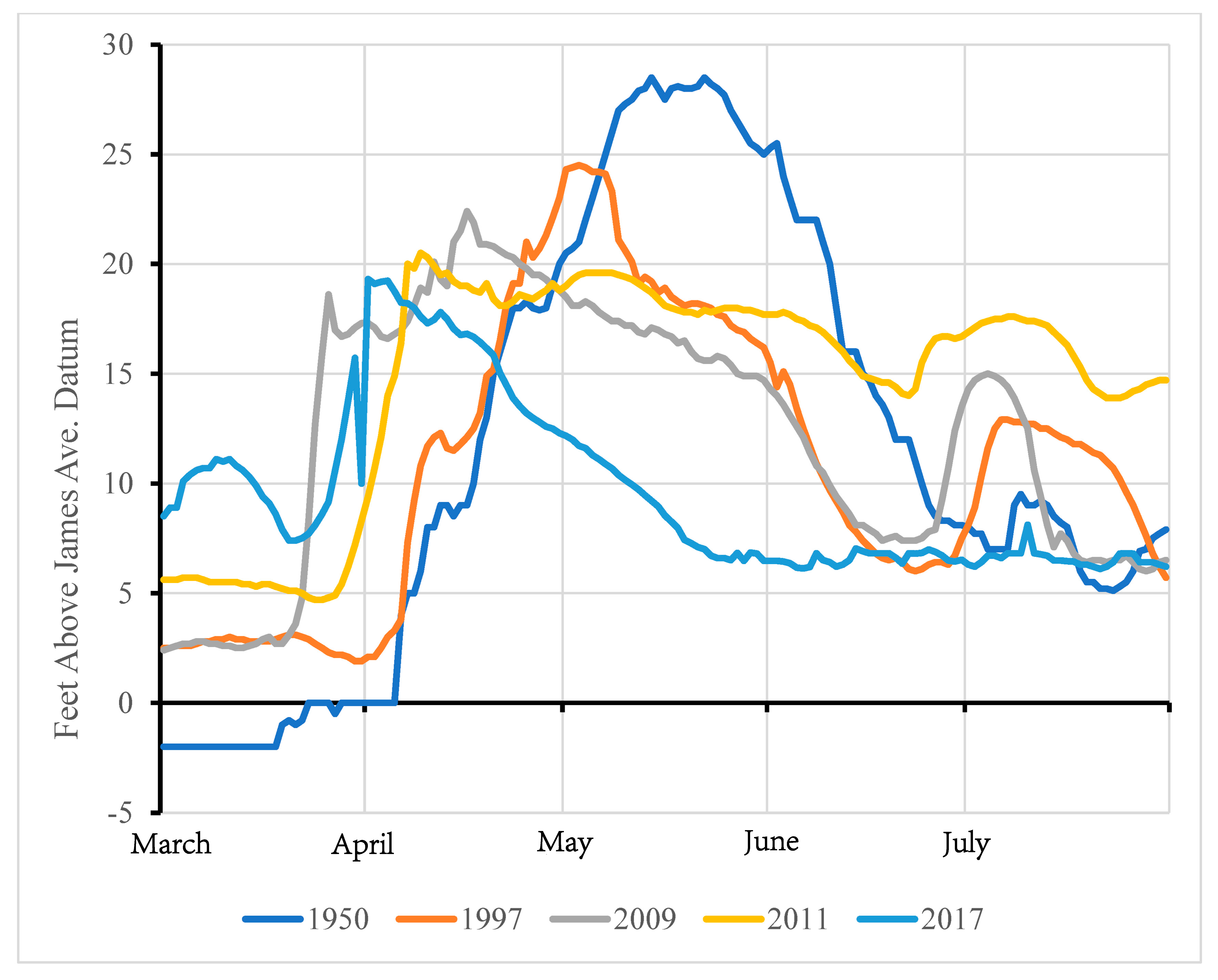
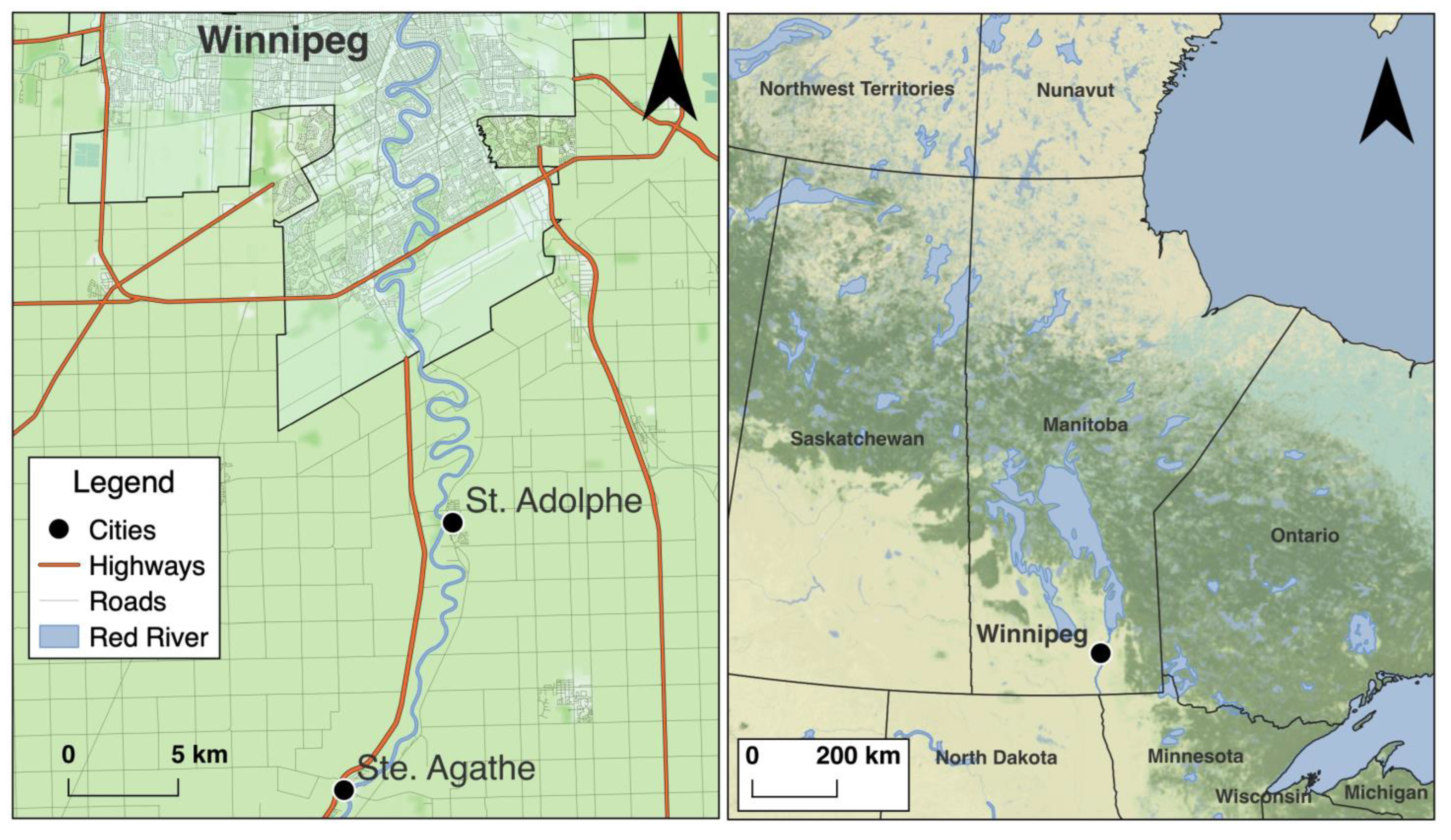
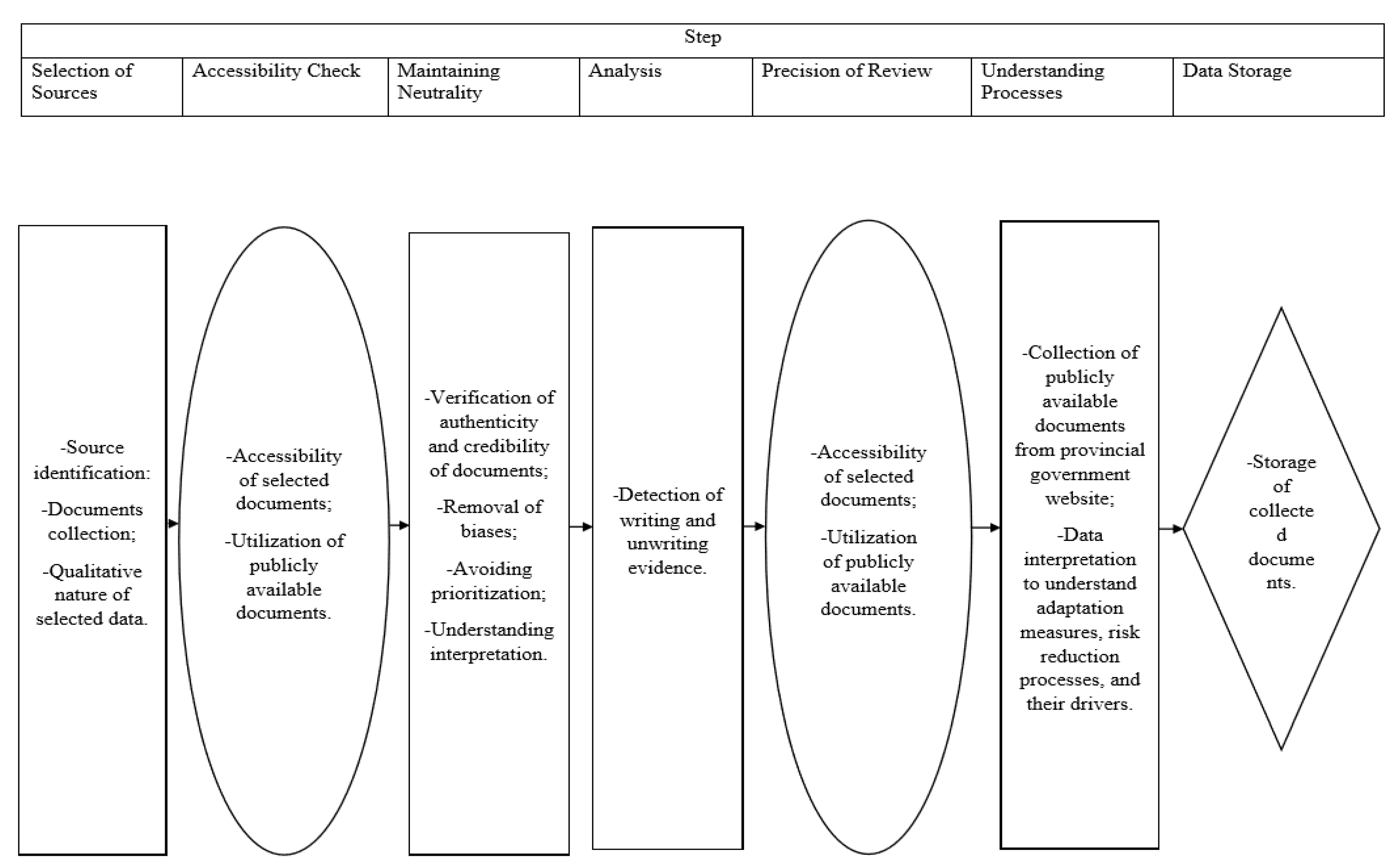
Table 1.
Comparison of flood years in relation to natural spring peak discharges and natural spring peak stages measured at James Avenue, Winnipeg (the zero point of the gauge is 727.57 ft. above mean sea level) (Source of data: Manitoba Conservation and Water Stewardship, 2014). Note: 1974, 1979, 1996, 1997, 2006, 2009, and 2011 were computed without the use of Red River Floodway, Portage Diversion, and Shellmouth Dam.
| Year | Natural Spring Peak Discharges in Cubic Feet per Second (Cusec) in ‘000 | Natural Spring Peak Stages in Feet above Datum |
|---|---|---|
| 1826 | 225,000 | 36.5 |
| 1852 | 165,000 | 34.5 |
| 1861 | 125,000 | 32.2 |
| 1950 | 108,000 | 30.3 |
| 1974 | 96,000 | 28.0 |
| 1979 | 108,000 | 30.3 |
| 1996 | 108,000 | 30.3 |
| 1997 | 163,000 | 34.4 |
| 206 | 99,000 | 28.5 |
| 2009 | 128,000 | 32.5 |
| 2011 | 116,000 | 31.2 |
Table 2.
Local community-level factors of coping and adaptation strategies.
| Risk Reduction, Coping, and Adaptation Strategies | Driver | Learning |
|---|---|---|
| Individual action | ||
|
|
|
| Working with volunteers | ||
|
|
|
| Community initiatives | ||
|
|
|
| Social support | ||
|
|
|
Table 3.
Interaction between governments, NGOs, and communities for coping with and adapting to floods.
Table 3.
Interaction between governments, NGOs, and communities for coping with and adapting to floods.
| Risk Reduction, Coping, and Adaptation Strategies | Driver | Learning |
|---|---|---|
| Communication and information sharing | ||
|
|
|
| NGO support | ||
|
|
|
| Government support | ||
|
|
|
| Changes in municipal council | ||
|
|
|
| Shift of authority | ||
|
|
|
| Evacuation | ||
|
|
|
| Impact of waves | ||
|
|
|
| Integrative measures | ||
|
|
|
| Education | ||
|
|
|
| Physical intervention | ||
|
|
|
| Land use planning to reduce flood exposure | ||
|
|
|
| Risk communication | ||
|
|
|
Table 4.
Coping and adaptation initiatives by nonprofit organizations.
| Risk Reduction, Coping, and Adaptation Strategies | Driver | Learning |
|---|---|---|
| Collaboration | ||
|
|
|
| Newer methods | ||
|
|
|
| Change in perception | ||
|
|
|
| Inexpensive alternative | ||
|
|
|
| Provincial funding | ||
|
|
|
| A common platform | ||
|
|
|
Table 5.
Multilevel challenges of coping and adaptation to floods in locallevel flood management in Manitoba.
Table 5.
Multilevel challenges of coping and adaptation to floods in locallevel flood management in Manitoba.
| Challenging Issues | Associated Actors/Stakeholders |
|---|---|
| Support from the government | |
|
|
| Flood memory and collective amnesia | |
|
|
| Lack of community-level preparedness | |
|
|
| Disregard for emotional value | |
|
|
| Community involvement in flood management | |
|
|
| Local-level administration | |
|
|
| Transparency at the provincial government level | |
|
|
| Communication gap | |
|
|
| Private flood insurance coverage | |
|
|
| Challenges faced by non-profit and nongovernmental organizations | |
|
|
Disclaimer/Publisher’s Note: The statements, opinions and data contained in all publications are solely those of the individual author(s) and contributor(s) and not of MDPI and/or the editor(s). MDPI and/or the editor(s) disclaim responsibility for any injury to people or property resulting from any ideas, methods, instructions or products referred to in the content. |
© 2023 by the authors. Licensee MDPI, Basel, Switzerland. This article is an open access article distributed under the terms and conditions of the Creative Commons Attribution (CC BY) license (https://creativecommons.org/licenses/by/4.0/).
Share and Cite
MDPI and ACS Style
Haque, C.E.; Zaman, J.R.; Walker, D. Risk-Reduction, Coping, and Adaptation to Flood Hazards in Manitoba, Canada: Evidence from Communities in the Red River Valley. Geosciences 2023, 13, 88. https://doi.org/10.3390/geosciences13030088
AMA Style
Haque CE, Zaman JR, Walker D. Risk-Reduction, Coping, and Adaptation to Flood Hazards in Manitoba, Canada: Evidence from Communities in the Red River Valley. Geosciences. 2023; 13(3):88. https://doi.org/10.3390/geosciences13030088
Chicago/Turabian StyleHaque, C. Emdad, Jobaed Ragib Zaman, and David Walker. 2023. "Risk-Reduction, Coping, and Adaptation to Flood Hazards in Manitoba, Canada: Evidence from Communities in the Red River Valley" Geosciences 13, no. 3: 88. https://doi.org/10.3390/geosciences13030088
Note that from the first issue of 2016, this journal uses article numbers instead of page numbers. See further details here.