


Big Data, Small Island: Earth Observations for Improving Flood and Landslide Risk Assessment in Jamaica
by
 , , and
Cheila Avalon-Cullen
1,2,* ,
,
Christy Caudill
2,3,
Nathaniel K. Newlands
2,4 and
Markus Enenkel
2,5 1
The Graduate Center, Bronx Community College, NOAA CREST Remote Sensing Earth System Institute, The City University of New York, 365 5th Avenue, New York, NY 10016, USA
2
Group on Earth Observations WG-DRR, 7 bis, Avenue de la Pais Case postale 2300, CH-1211 Geneva, Switzerland
3
Department of Earth Sciences, Institute for Earth and Space Exploration, University of Western Ontario, 1151 Richmond St., London, ON N6A 5B7, Canada
4
Summerland Research and Development Centre, Government of Canada (Agriculture and Agri-Food Canada), 4200 Highway 97 S, Summerland, BC VOH 1Z0, Canada
5
Harvard Humanitarian Initiative, Harvard University, 14 Story St., Cambridge, MA 02138, USA
*
Author to whom correspondence should be addressed.
Geosciences 2023, 13(3), 64; https://doi.org/10.3390/geosciences13030064
Submission received: 26 November 2022
/
Revised: 5 February 2023
/
Accepted: 15 February 2023
/
Published: 24 February 2023
(This article belongs to the Special Issue Scientific Assessment of Recent Natural Hazard Events)
Abstract
:The Caribbean region is highly vulnerable to multiple hazards. Resultant impacts may be derived from single or multiple cascading risks caused by hydrological-meteorological, seismic, geologic, or anthropological triggers, disturbances, or events. Studies suggest that event records and data related to hazards, risk, damage, and loss are limited in this region. National Disaster Risk Reduction (DRR) planning and response require data of sufficient quantity and quality to generate actionable information, statistical inferences, and insights to guide continual policy improvements for effective DRR, national preparedness, and response in both time and space. To address this knowledge gap, we review the current state of knowledge, data, models, and tools, identifying potential opportunities, capacity needs, and long-term benefits for integrating Earth Observation (EO) understanding, data, models, and tools to further enhance and strengthen the national DRR framework using two common disasters in Jamaica: floods and landslides. This review serves as an analysis of the current state of DRR management and assess future opportunities. Equally, to illustrate and guide other United Nations Disaster Risk Reduction (UNDRR) priority countries in the Pacific region, known as Small Island Developing States (SIDS), to grapple with threats of multiple and compounding hazards in the face of increasing frequency, intensity, and duration of extreme weather events, and climate change impact.
1. Introduction
The nature and scale of risk have changed. In our increasingly complex, interconnected world, risk has become systemic, challenging governance mechanisms of established risk management institutions and approaches that neglect cascading or compounding risks [1]. In March 2022, United Nations Secretary-General António Guterres launched a new initiative that calls for action to meet the urgency of precipitating climate change events spurred by the recent Intergovernmental Panel on Climate Change (IPCC) report. This initiative positions Earth Observation (EO)-based services as critical tools to understand integrated systemic risk and provide pivotal strategic support to reduce disaster risk and support climate adaptation. EO data, models, and tools provide timely information to help anticipate storms, heatwaves, floods, and droughts, and thus, represent key national investments in adaptation and resilience [2].
Despite progress in disaster risk reduction (DRR) and policy adoption globally since 2005 (i.e., under the Hyogo Framework for Action (HFA) regime, 2007–2015), the prevalence and severity of natural hazards continue to increase [3]. Recent findings of a global study on policy response to hazards reveal that events—no matter how frequent or severe—are not driving changes in national DRR policy. In 2021, The Group on Earth Observations (GEO) and the United Nations Committee of Experts on Global Geospatial Information Management (UN-GGIM) developed the Aguascalientes Declaration—to advance the use of EO, Statistical Science, and other data-driven approaches for addressing disaster risk. Among the mandates of this Declaration are bridging the digital divide, building knowledge and capacity, and advancing the tangible use of EO [4]. To meet these mandates, GEO’s DRR working group and the Committee on Earth Observation Satellites (CEOS) are working with governmental partners to develop case studies of EO integration into National DRR strategic policies. The innovative and collaborative case studies are examples of scalable and replicable methods to advance and integrate the use of EO, specifically detailing the coordinated efforts to support risk-informed decision-making based on documented national and subnational needs and requirements. This paper explores the case study of EO-informed disaster risk reduction and the integration of EO-driven decision-support tools into the National Disaster Risk Plans for the Small Island Developing States (SIDS) of Jamaica using floods and landslides as examples.
SIDS are recognized as a grouping of 58 small island developing countries located in the Atlantic and Indian Oceans, Caribbean, and Pacific regions. This classification is significant for greater awareness and convergence on a global strategy to support these nations, which face disproportionate—and devastating—climate change impacts, despite being responsible for only 0.2% of global carbon emissions [5]. SIDS tend to be highly vulnerable to extreme weather and climate events, including floods, landslides, or tropical storms, yet lack sufficient resilience to deal with the rising incidence of the effects of climate change.
As a SIDS, Jamaica accounted for 11% of disasters in the Caribbean region between 1981 and 2018. The country is particularly vulnerable to hurricanes, whose effects are often exacerbated by other hazards such as floods and landslides [6]. According to Jamaica’s 2018 Communication to the United Nations Framework Convention on Climate Change, several storms in the past decade alone have had profound consequences on agricultural production, food security, and local livelihoods, with severe flooding damage, loss of lives, and destruction of goods and services totaling $129 billion. As disasters pose a significant threat to Jamaica’s infrastructure, human life, and economic development, the Jamaican government is actively seeking ways to better utilize EO in addressing integrated risks. The Climate Change Policy Framework and Action Plan of Jamaica lay out the framework for Jamaica’s response to climate change [7]. Nonetheless, the report also notes impediments for acting on the recommendations, such as including guidelines that could not be adequately defined; recommendations that were deemed inadequate or unnecessary; the time frame was not sufficient for efficient execution; and data or other resources could not be obtained.
In this paper, we explore the potential for integrating state-of-the-art EO information, multi-hazard risk models, and other complementary tools within the Jamaican disaster management framework. This work is designed as an exploratory first step, and it is motivated by the need for a co-development approach between DRR stakeholders in Jamaica and EO experts to help meet the impediments noted in Jamaica’s climate change action plan. Co-development with identified DRR stakeholders in Jamaica about the process and practice of EO utilization can provide actionable pathways for EO information, so that it can be harnessed for enhancing and improving their national DRR efficiency and effectiveness.
This paper takes a literature review approach to provide an objective critical analysis of current scientific and technological knowledge, focusing on two primary hazards, namely: floods and landslides. We summarize the challenges and potential benefits associated with this integration. We begin by describing Jamaica’s current national disaster framework as it delineates hazards and defines policies and strategies to prevent, mitigate, and respond. Then, in Section 3, we overview the country’s geophysical characteristics and associated natural hazard vulnerabilities, we focus on two of the most common disasters: floods and landslides. In Section 4, we review some of the past and current efforts to evaluate these risks for Jamaica. Next, in Section 5, we look at potential EO tools, models, and databases available and applicable to Jamaica as a Small Caribbean Island. We then describe strategies on how EO resources and capacity building can benefit and complement the current national disaster framework.
2. Jamaica National Disaster Framework (NDF)
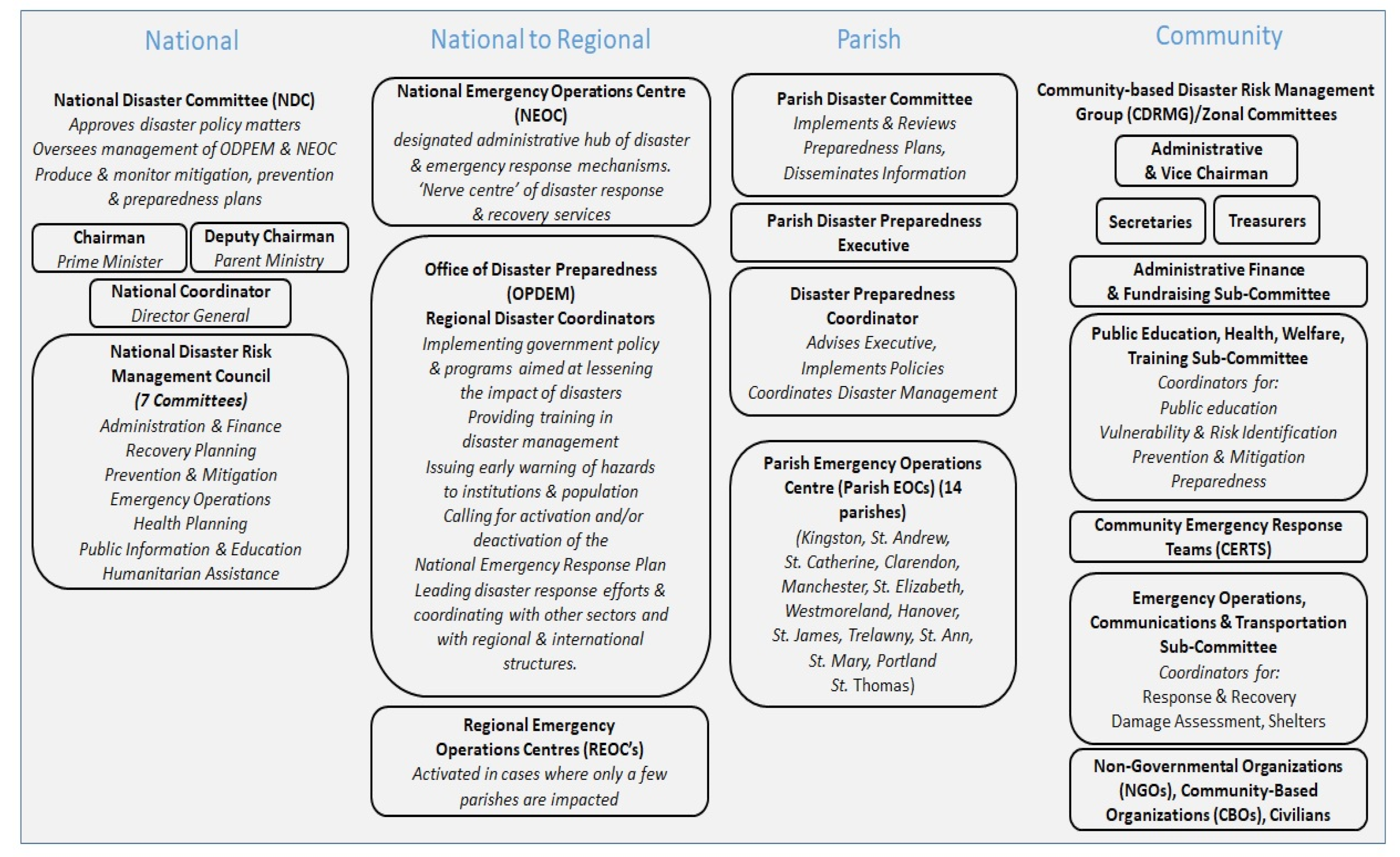
The responsibilities of the National Disaster Committees vary from country to country within the Caribbean [8]. Nonetheless, their primary role is to identify hazards, define policy strategies to prevent and mitigate damages, and to make preparedness, response, and rehabilitation determinations. In Jamaica, the Prime Minister is Chairman of the National Disaster Committee (NDC). The NDC meets once annually to approve disaster policy matters and has an Executive (NDE) that oversees the management of the operational national disaster management offices; namely, the Office of Disaster Preparedness and Emergency Management (ODPEM) and National Emergency Operations Centre (NEOC). Jamaica’s NDF comprises four mechanism levels (national, regional, parish, and community), shown in Figure 1 below.
The NDE Committees produce and monitor mitigation, prevention, and preparedness plans, while the ODPEM implements them by providing education, training, and other liaison activities with Parish Councils, Non-Governmental, and Community-based organizations (NGOs and CBOs, respectively). Councils for each of Jamaica’s 14 parishes are mandated to provide disaster relief at the local level. Regional Emergency Operations Centers (REOCs) activate in cases where only a few parishes are affected.
3. Jamaica: Hazards and Impacts
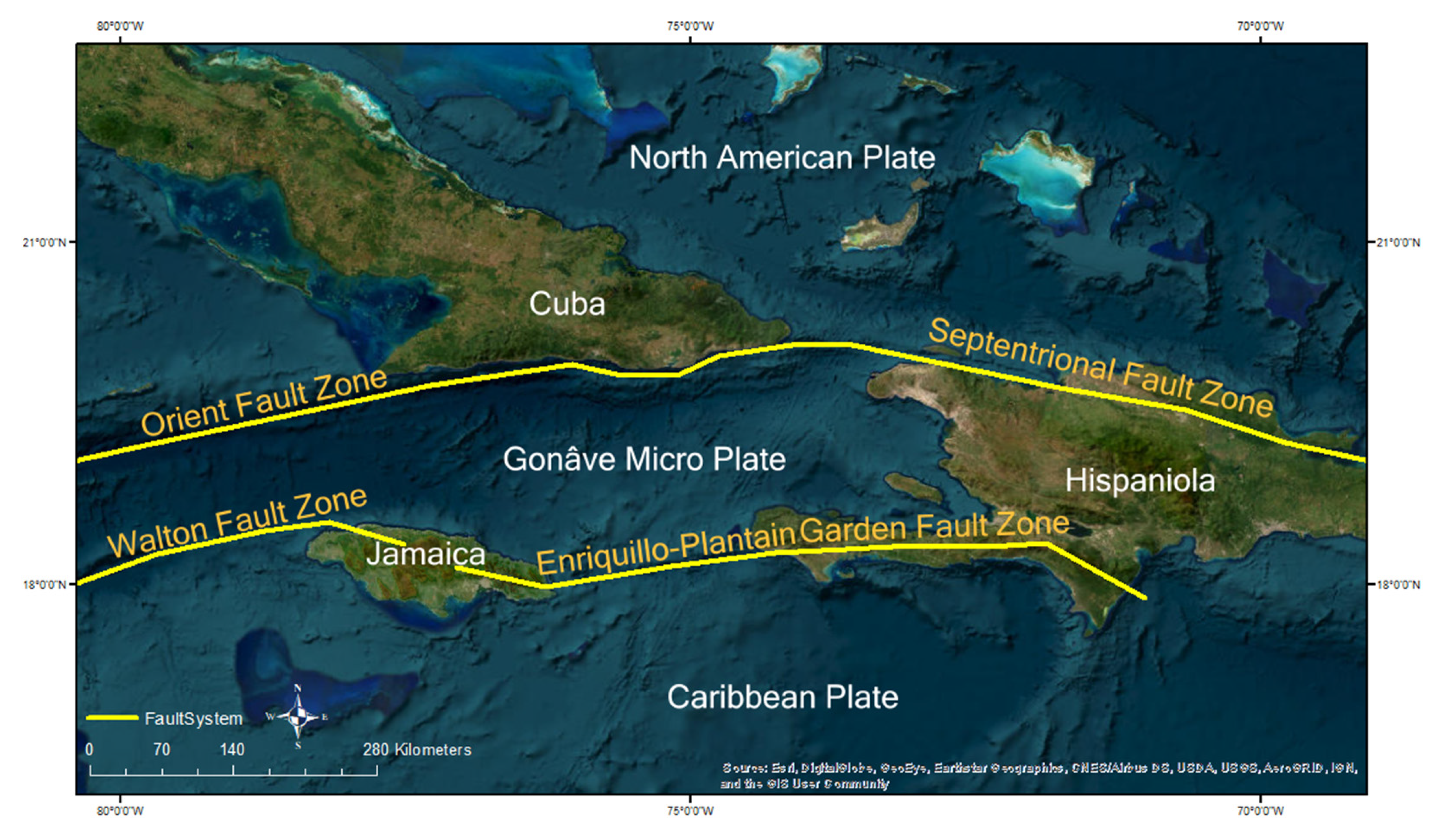
Jamaica is the third-largest island of the Greater Antilles in the Caribbean. Kingston, on the southeastern coast of the island, is the capital and largest city, driving the economy with major industries such as tourism, manufacturing, and shipping [11]. Jamaica presents complex geographical and hydro-climatological characteristics due to its tectonic and Caribbean location. Its geomorphological configuration arises from a complicated and young convergent/strike-slip margin known as the Enriquillo–Plantain Garden Fault system, as seen in Figure 2 below. The interior of the island is dominated by a series of mountain ranges, where the Blue Mountains, in the east, are the longest mountain range and include the highest topographic peak in Jamaica, rising to 2256 m [12]. This complicated tectonic setting has resulted in various devastating historical earthquakes, such as the 1692 Jamaica, the 1751 Hispaniola, the 1907 Kingston, the 2010 Port-au-Prince, and the 2021 Haiti earthquakes [13,14].
Because of its Caribbean placement, Jamaica is subject to the overall regional bimodal seasonal rainfall pattern of early (April–July) and late (August–November) and a general mid-summer drought [15]. The northeastern area of Jamaica receives the highest rainfall yearly average of more than 400 mm, with the Blue Mountains averaging more than 625 mm per year. Jamaica is also significantly exposed to tropical storms, with at least 11 named storms making landfall between 1988 and 2012 [15,16,17]. In both cases, this rainfall surplus usually causes floods, flash floods, and landslides throughout the island [17]. Figure 3 below shows the recurrence of floods and landslides affecting the island from 1973 to 2017 as reported in the EM-DAT global natural disasters database [18] and NASA’s global landslide catalog [19]. EM-DAT does not provide more recent information. These natural hazards heavily affect the Jamaican population, estimated at 2.8 million people today, and result in significant GDP losses [11,20].
3.1. Flooding Hazards
Although hurricanes usually have devastating consequences for island countries in the tropics, heavy precipitation storms are more frequent and intense in this region. Tropical rainfall is usually localized, and mostly convective. For islands like Jamaica, where steep topography abides the production of heavy rainfall, large amounts of precipitation occur over high elevations that increase as wind speed increases [17]. Furthermore, it is expected that global climate change will impact regional precipitation patterns and thus influence the recurrence of associated risks [21,22,23]. Moreover, due to limited natural and human resources, topography, population size, and economy, small Caribbean islands like Jamaica have been identified as most vulnerable to climate change and extremes [15,24]. Therefore, various studies aim to 1. Understand these changes, and 2. Identify those risks associated with precipitation intensity and distribution. For example, in a study to build capacity and improve climate change knowledge in the Caribbean region, Stephenson et al., (2014) [15] using observational surface temperature and precipitation data from weather stations between 1961 and 2010, demonstrated a warming trend in the surface air temperatures at those stations. This study also found that, although less consistent, changes in precipitation follow the Atlantic multidecadal oscillation (AMO), with June and October showing the strongest correlations [15]. In another study, Laing et al. (2004) [17] looked at the specific convection mechanisms associated with heavy precipitation that was later related to various flash flood events in Jamaica during the 1990s. In this case, the author determined that steep terrain and river basin topography played a significant role in the intensity of the downpours. More importantly, the author highlighted that these episodes occurred during the dry season in the Caribbean. However, being an El Niño year, it largely influenced deep convection and heavy precipitation [17]. These findings leave the region at a possible high risk for hydro-climatological hazards at any time of the year. Other studies focus on identifying specific risks associated with Jamaica’s hydroclimatic settings and corresponding changes. The literature points out two common hazards: floods and landslides, with flooding being the most common disaster in Jamaica [25].
At least 66% of the population and 70% of the economic infrastructure in Jamaica is situated along or near the coastline [26]. Costal areas are the island’s economic nucleus for tourism and shipping. However, the coastal area is highly vulnerable to tropical cyclones, storm surges, and sea level rise, all of which result in flooding. Besides being highly vulnerable to tropical cyclones, Jamaica is also prone to extreme rainfall events that historically have resulted in significant losses for non-coastal areas dedicated to agricultural production due to river flooding [11].
3.2. Landslide Hazards
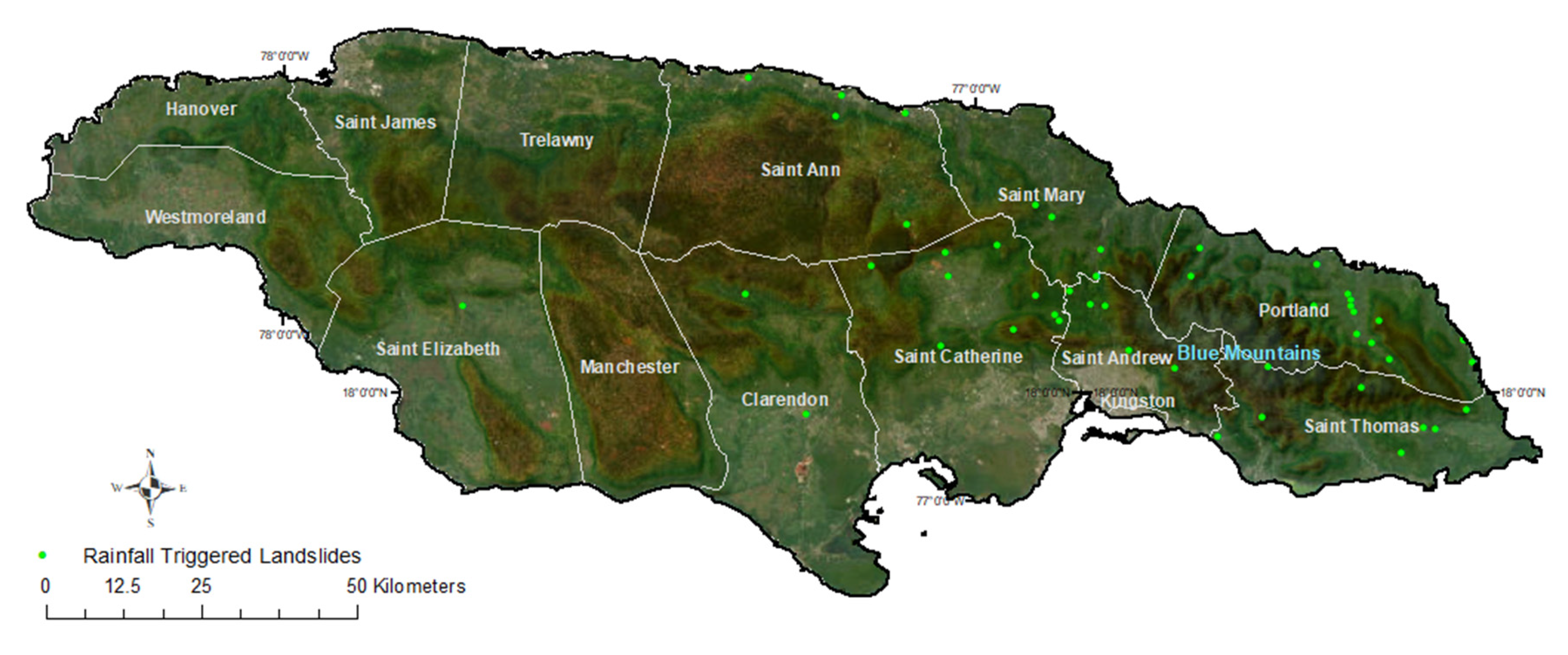
Rainfall-triggered landslides associated with long-term or high-intensity periods of precipitation are one of the most common phenomena in slanted slopes worldwide [27]. Jamaica is no exception. Over the past two decades, several rainfall-triggered landslides have occurred on the island around the eastern high mountain regions, where the parishes of Portland, St. Andrew, St. Thomas, St. Mary, St. Catherine, and St. Ann exhibit the highest incidence of these events. Historically, devastating landslides like the Judgment Cliff landslide of St. Thomas in 1692 (initiated by the earthquake but triggered by torrential rains), the Millbank landslide of Portland in 1937, and the Preston landslide of St. Mary in 1986 have resulted in significant economic and human losses [28]. The parishes of Portland and St. Thomas are particularly affected by rainfall-triggered landslides happening during periods of heavy downpours and resulting in road blockages and damages, village and town isolation, damage to forests, and damming of rivers costing millions of dollars [28,29]. Miller et al., (2009) [28] for example, investigated rainfall intensity thresholds that could initiate a landslide in the parish of St. Thomas while highlighting low, medium, and high susceptibility zones, where those categorized as medium susceptibility are likely to experience landslides only if existing ground conditions are significantly altered, and high susceptibility areas are more prone to landslides due to environmental or climatic conditions [28]. Similarly, Bhalai et al., (2010) studied landslide susceptibility in the parish of Portland, where high landslide susceptibility happens between 200 and 1000 m elevations in the steeper slopes of the Blue Mountains [29].
The Unit for Disasters Studies from the University of West Indies developed a landslide hazard map for the Kingston metropolitan area because of the Kingston Multi-hazard Assessment Project of the Caribbean Disaster Mitigation Project in 2010. The maps highlighted susceptible areas where mitigation may be needed delineating debris flow areas and past damage to houses, roadways, and factories. The map authors describe the challenges of continued mapping and knowledge dissemination due to a lack of resources. The maps can still be accessed here: https://www.mona.uwi.edu/uds/Land_Jam.html (accessed on 1 November 2022). Although in-depth susceptibility mapping for all other parishes is not readily available in the literature, rainfall-triggered landslides affect large and populated areas of the island, as shown in Figure 4 below.
4. Efforts to Determine Flood and Landslide Disaster Susceptibility in Jamaica
A deep understanding of the characteristics, trends, causes, and duration of hydro-climatological triggering hazards in Jamaica are limited. Few studies have tried to estimate current or projected risks as part of adaptation to climate change. Much of this is due to the lack of data, insufficient temporal and spatial data availability, and their impact on model development.
EM-DAT defines and records a “disaster” based on a number of factors, uncluding an event having caused ten deaths, 100 or more people to have been affected, a declaration of a state of emergency, or a call for international assistance [19]. In the case of Jamaica, Burgess et al. (2015) [6] is one of the few studies that attempts to bridge the existing data gap by redefining more suitable methodologies for spatial and loss of life at scales applicable to SIDS. Much of the data used in the research were obtained from Jamaican governmental agencies. There were several critical data gaps, which ultimately led to the use of global datasets. The authors compiled information on floods, tropical cyclones, and significant weather systems that affected Jamaica from 1678 to 2010, this resulted in a comprehensive database of events, subsequent deaths, and economic losses. They investigated climate-severe flood correlations, reported on the annualized loss of life, and developed macro-scale flood risk models. Findings demonstrated an 11% increase in severe floods due to climate influences such as ENSO and the AMO but a relatively stable cost per event. Burgess et al. (2015) [6] attributed this stagnation to the past 20-year investment in urban drainage. Results also averaged the loss of life at a rate of 4.4 people per year. The Burgess et al. (2015) database highlights the importance and relevance of information resolutions for risk modeling, as it reports 152 events for Jamaica, whereas the global EM-DAT catalog only lists 42 events for the area. The authors highlight similar discrepancies in the EM-DAT dataset, as it over-reports deaths [6]. These findings underline the importance of standardized definitions and criteria for flood risk and highlight the value of addressing these definitions locally, so they are efficient for National Disaster Risk Management [6].
Using a more local approach, Glas et al. (2017) [30] derived a quantitative damage map of Annotto Bay, a small town in St. Mary’s parish, using a modified version of the risk assessment tool LATIS [30]. The authors described that LATIS assisted Flemish policymakers in selecting appropriate risk reduction for Belgian regions. Nevertheless, the same functions approach was not suitable for this study area. Using satellite imagery from IKONOS, a DEM, bathymetric data, historical storm tracks from NOAA, and wind-wave model JONSWAP as inputs, the authors developed a maximum damage map for all elements at risk in urban and rural areas. They concluded that floods with the same height have a greater effect on the built areas and estimated that the total maximum damage was around $166 million. Regardless of these findings, these authors again highlight the limitations of the available data. Hence, creating a risk map was not possible due to the lack of flood information [30].
5. Capacity-Building: Gaps and Needs
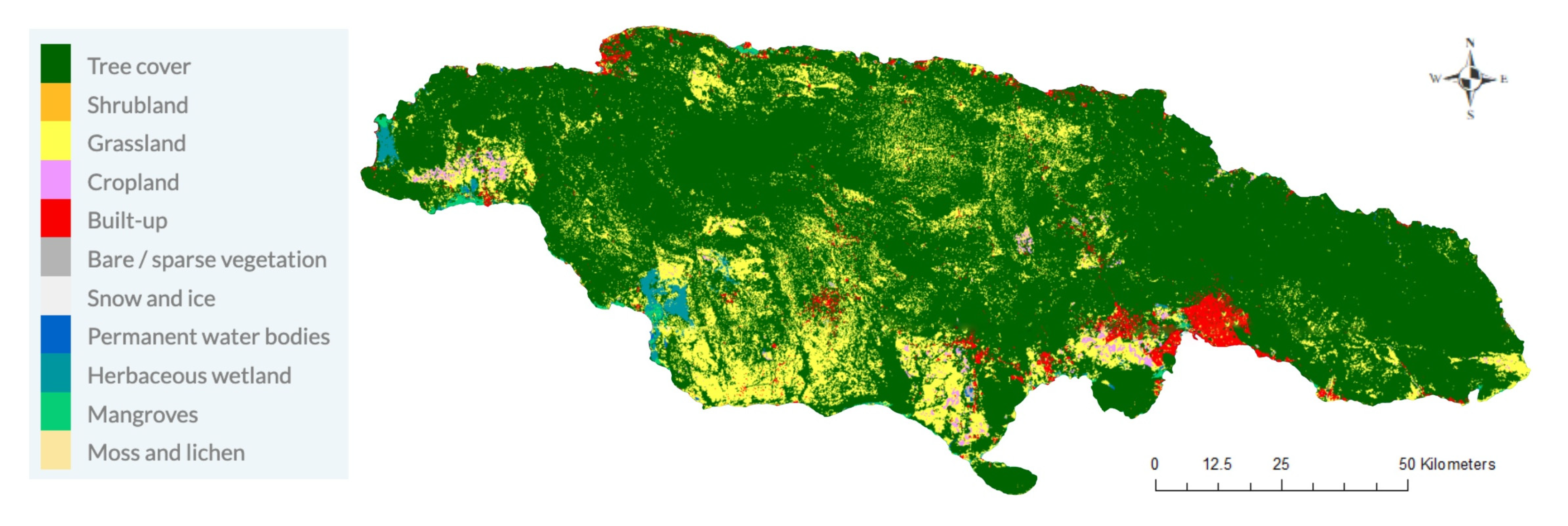
Zitoun et al. (2020) [31] produced a comprehensive assessment of the human resources and institutional capacities of SIDS to respond to and address challenges related to climate change. SIDS are at a major disadvantage in the global disparities in resources to cope with a changing climate and its disastrous events, including human resources and technological capacities. All disaster risk management phases (mitigation, preparedness, response, recovery) rely heavily on satellite-derived information. However, the entry barrier to integrating EO into existing decision-making workflows is still high due to various reasons. Most notably, these limitations are the technical capacities to translate data into actionable information, misunderstandings regarding the characteristics and costs of EO data, or actual technical limitations, such as data quality, spatial resolution, or timeliness [32]. Jamaica exhibits several features that tend to result in challenges for various types of EO data, such as the island’s topography (almost 50% of the surface is located 330 m above sea level or higher) or dense vegetation cover, as shown in Figure 5. The former for instance, can present problems for different types of satellite sensors (e.g., RADAR), as they can interfere with the ability of the instrument to accurately measure the surface or interpret the data collected [33]. The latter results in challenges for the estimation of soil moisture conditions via radar sensors and, subsequently, in negative impacts on the development of applications, such as landslide models [34,35]. One of the most important skills regarding the use of EO data is to understand how and when to use them, but also when not. In this context, the problem for SIDS is that there is a proportionally smaller pool of skilled people to contribute to the development of EO-based services, while the development does not require proportionally less (to the small land mass) human resources [36]. It is important to highlight additional challenges for all kinds of climate services in Jamaica, such as unclear funding to support the development of tailored products or uncertainty regarding coordination and leadership [37].
6. Potential EO for Improving Flood and Landslide Risk Assessment in Jamaica—The Power of Models, Satellites, Databases, and Capacity Building
6.1. Models
Risk models utilize a range of data sources such as past flood event locations, topography, precipitation, temperature, hydrology, land cover, and soil cover data (susceptibility) including population demographic data (exposure) and socio-economic data (vulnerability). We refer readers to a recent review of multi-hazard risk methodologies that was conducted recently as part of a project commissioned by the World Bank to identify drivers of climate and environmental fragility in Burundi [38]. Multi-hazard risk analytical methodologies seek to capture floods and landslides into a single assessment and can be qualitative, quantitative, or semi-quantitative. Recent advancements and innovations in artificial intelligence (AI) (i.e., machine learning, ML and deep learning, DL) modeling of multi-hazard risk have a high potential for application in Jamaica. DL models attain increased accuracy and computational power in multi-hazard, including flood and landslide, hazard mapping, inundation, and susceptibility prediction, compared to traditional approaches based on current research findings [39,40,41,42]. DL applications include probabilistic hazard maps, flood risk, breach flood events, real-time flood warnings, and flood arrival prediction. Currently, the two most popular approaches are the multi-layered perceptron (MLP) for its flexibility and ease of implementation, and the CNN (convolution neural network), which is well suited for processing EO imagery data. While a DL methodology could be developed for Jamaica, learning from the latest DL research insights, such models require large quantities of data to achieve good performances, such that new data sources (station observations, EO, etc.) and data fusion (i.e., finer resolution unmanned aerial vehicle, UAV data with coarser EO satellite data) is often needed to overcome data limitations.
The humanitarian sector is transitioning towards more risk-informed, forward-looking approaches. The concept of climate science translators (CST) has been developed under this context [43]. Many of the skills required by CSTs are equally applicable to the use of EO for flood and landslide risk management in Jamaica, for instance:
- Knowledge of strengths and limitations of Multi-Hazard Early Warning Systems (MHEWS), climate data, and services from various sources (including, but not limited to satellite-derived, modeled, assimilated data, or in-situ data); The specialized Climate Risk and Early Warning Systems (CREWS) initiative of the World Meteorological Organization recently committed additional funding to strengthen Early Warning Systems in the Caribbean SIDS
- The capacity to understand concepts of uncertainty, accuracy, and skill related to climate and weather data
- Understanding mechanisms to integrate new sources of information and methods into existing workflows
With a strong focus on EO risk modeling, the United Nations Institute for Training and Research (UNITAR) has recognized the need to build resilience in SIDS in the context of a project named Common Sensing, that focuses on Fiji, Vanuatu, and the Solomon Islands. The project emphasizes three main goals around improved disaster risk reduction, access to climate finance, and the support of national or even regional climate action policies—all areas that are equally relevant for Jamaica.
In the face of increasing data volumes, cloud data storage and processing capacities, such as Google Earth Engine (GEE) are likely to add value regarding EO-driven risk modeling insights for SIDS. Additionally, TensorFlow, an end-to-end machine learning platform can be used with GEE, particularly for more complex models, larger training datasets, more input properties, or longer training times are required. In parallel, several other applications that combine EO with ML to estimate socioeconomic and environmental conditions in data-poor regions are evolving [36]. One example is the MOSAIKS approach, developed at UC Berkeley and UC Santa Barbara, to provide everyone—from researchers to government officials—an easy and affordable way to access and instrumentalize EO data. MOSAIKS allows one person with a standard computer and basic statistical training to use satellite imagery to solve the problems that are relevant for any local context—also DRM-related activities in SIDS.
6.2. Satellite-Derived Information and Databases
Advances in remote sensing techniques have opened multiple opportunities for understanding many planetary processes. Remote-sensed data has demonstrated the capacity to help bridge the gap between field surveys and stations, at least at the global level, but more so in remote areas that are hard to reach or maintain [44]. The development of various types of remotely sensed information (elevation, land cover, topography, rainfall, soil moisture, distance to settlements, flood extent, water level, etc.) have become essential in deciphering how these hazards evolve and affect people via modeling the risk of floods and landslides. Over the past few decades, a plethora of research has focused on utilizing these techniques alone or in combination with in situ retrieved data to understand landslides and flooding, both at different scales [30,45,46,47,48,49,50,51,52,53,54,55,56,57,58]. Here in Table 1, we list satellite-based tools and datasets applicable for understanding landslides and floods at effective spatial resolutions for SIDS like Jamaica. Additional information and examples from the literature are provided.
6.2.1. The Climate Hazards Group Infrared Precipitation with Stations—CHIRPS
The United States Geological Survey (USGS) and the Climate Hazard Group (CHG) at the University of California Santa Barbara (USCB) developed The Climate Hazards Group Infrared Precipitation with Stations (CHIRPS) effort to support the United States Agency for International Development Famine Early Warning System Network (FEWS NET). CHIRPS builds on various thermal infrared (TIR) precipitation products, calibrates global cold cloud duration rainfall estimates with the Tropical Rainfall Measuring Mission Multi-Satellite Precipitation Analysis version 7 (TMPA 3B42 v7), and uses various interpolated gauge products. CHIRPS data are available globally from 6-h to 3-month aggregates at a 0.050 × 0.050-degree spatial resolution for the planet [59]. CHIRPS has been used to determine the hydrological impacts of drought in the Great Horn of Africa; support hydrological forecast and trend analyses in Ethiopia, and act as a proxy for antecedent soil moisture content helping to determine rainfall-triggered landslide risk in the tropics.
Because CHIRPS interpolates ground-gauges and satellite information, it is thus helpful to model soil moisture dynamics in tropical soils. Cullen et al. (2022) [45] used CHIRPS rainfall data to develop a threshold that simulates the state of wetness of the soil before a landslide triggered by rainfall happens in the high-slope mountains of Colombia [45]. Usually, heavily vegetated terrains with high slopes are challenging for satellites to gather accurate information. In tropical localities such as Jamaica, models like this can be helpful to determine the likelihood and flood risk of rainfall-triggered landslides.
6.2.2. The Global Precipitation Mission—GPM
NASA’s Global Precipitation Measurement (GPM) provides observations of rain and snow worldwide every three hours. Among the applications of GPM data are understanding and forecasting tropical cyclones, extreme weather, floods, landslides, the spread of water-borne diseases, agriculture, freshwater availability, and climate change [60].
GPM’s Integrated Multi-satellitE Retrievals (IMERG) product is one of the most used tools for floods and landslides. Ma et al. (2020) [61] for example, investigated the accuracy of the near-real-time IMERG-Early product and the post-real-time IMERGE-Final product with a temporal resolution of 6-h in the application of flash flood warnings for the Yunnan Province in China. Their study established that IMERGE-Final results in an acceptable accuracy over the study area, and it performs better than EMERG-Early. They conclude that IMERGE-Final helps develop flash flood warnings in an area where at least 84% of the region is mountains, 10% are plateaus and hills, and 6% are basins [61].
In the case of a small island in the Caribbean, Jong (2017) [62] evaluated IMERG-Late product accuracy to estimate high-resolution described as rain intensity in mm/hour. This satellite-based risk assessment modeling was critical in Haiti during hurricane Mathew. The author explains that total accumulated values, instead of high resolution, present a better correlation with observations at the stations located in the northeastern region of the study area. Nevertheless, given the limited number of rain gauge stations, further investigation is needed [62]. For reasons like this, it is pivotal to initiate work on the applicability of these tools in SIDS.
6.2.3. Human Planet
The Human Planet Initiative is a Group of Earth Observations (GEO) initiative that generates global datasets to support novel evidence assessment of human presence on the planet [63]. The information is derived from satellites such as Landsat, Sentinel-1, and Sentinel-2 and other datasets to evaluate settlements and resiliency, environmental sustainability, quality of life, and hazard impacts. These open layers were created to inform decision-makers and support science and policy.
Ehrlich et al. (2021) [64] reviewed the applicability and effectiveness of these datasets, determining that in most instances, Global Human Settlements (GHS) datasets help address 13 thematic areas related to human presence, societal and hazard impacts, and their relationship to the environment at local, regional, and global scales [64]. The authors determined that green areas measured by satellites tremendously aid the understanding of the built environment: They relate to city air quality, help determine the physical size of settlements, and the outcomes of different approaches to land use. In addition, the work also highlights how satellite-based information and derived HP layers have been useful to identify opportunities for energy independence and help understand socio-economic pathways leading towards sustainable development. Furthermore, the authors highlight how GHS layers helped to map hazard risk and to measure increased exposure and vulnerability.
Human Planet was created to inform decision makers and its aims follow those set by international frameworks. Given the lack of finer-scale and greater-detailed data availability, HP may be helpful to fill information vacuums until local datasets in Jamaica become available.
6.2.4. The Earth Observations Risk Toolkit (EORT)
The EORT is a collaborative activity led by the Group on Earth Observations (GEO) Disaster Risk Reduction Working Group and the United Nations Office for Disaster Risk Reduction (UNDRR). The EORT is an open-source tool to help understand hazards, vulnerabilities, and exposure at a country level [65], and Jamaican governmental leadership, who are also active in the UN-GGIM, were pivotal in the co-design and co-development of the tool. The system’s primary purpose is to support emergency response agencies at the national level by providing access to EO data. The system provides free access to risk analysis tools, documents, and technical guidance to be used at a country level.
One of the EORT tools has already assisted advanced estimations of disaster risk. The GEOGIoWS ECMWF is a precipitation/flood forecasting EO tool that helped manage overflow during Hurricanes Eta and Iota in Honduras in 2020. The administrative National Electric Energy Company made controlled water discharges from a reservoir in response to the hurricanes, and the national disaster risk reduction agencies used the tool to inform evacuation decisions.
The tool’s capability to estimate the river overflow volume and the runoff resulting from the hurricanes provided helpful forecasts without additional cost to the stakeholders. Therefore, the damage to the affected area was considerably reduced compared to previous hurricanes that have affected the same locality. Capacity building for other experts and improvement of training materials is underway in Honduras, but the tool is now freely available for open use by other countries or stakeholders via the EORT website.
6.3. Capacity Building
A multi-sectoral, interdisciplinary approach best meets the complexities of systemic and compounded climatic and environmental risk analysis, including that of damaging storm surges and floods, and devastating landslides. The understanding of these risks and their impacts on decision-makers is necessary, but not sufficient: the understanding of systemic and compounding risks must be translated into actionable pathways to mitigate their effects with lasting, sustainable national-level policy and community-level implementation strategies. SIDS-specific challenges highlight the need for accessible and context-specific EO services to support effective decision-making. The integration of EO data and science-driven information into federal policy may be pivotal to guiding disaster risk management phases (mitigation, preparedness, response, recovery) and is crucial as a framework to enable decision-makers to exchange knowledge for science-informed action and operationalizing ownership. A better policy is made within human interaction; the interaction from national to community levels, and the interaction between scientists and technologists, and policymakers. One example of an actionable avenue to engage policymakers and ensure that critical and timely geospatial data “gets into the hands of those who need it” is the OS Open Data Masterclass, developed by the UK Ordinance Survey to build Earth Observation data literacy among policymakers. Engaging policymakers is about changing the culture of government through relationships, as EO specialists work with government workers and officials as a reciprocal exchange to harness the power of this science for the specific needs of the country and its communities. This knowledge exchange is part of project co-design and knowledge co-production principles that offer a holistic and participatory research approach of involving participants (as in this case study example, Jamaican government officials) in the development of tools, as well as naming the problems and solutions they aim to solve.
Meeting the needs of vulnerable Nation States means fundamentally meeting the needs of its vulnerable communities. Rölfer et al. (2020) [36] studied the gaps and opportunities in using EO for climate change adaptation for SIDS, and found that capacity building at the community level supported long-term adaptation planning, given the shorter-term pragmatic and political strategies often implemented federally. Adequate resources, infrastructure, institutional frameworks, and legal mechanisms should be in place to support capacity building at the local level as well as across sectors of society, to synergize limited human and financial resources. Furthermore, national dissemination channels are often absent or not effective to transfer national disaster risk management and incident mitigation strategies to the community level and other stakeholders. Moreover, they highlight the importance of co-designing approaches, wherein government and community, with academia, and internal and external EO experts like GEO, design EO-based disaster risk management services as a collaborative process. This puts the data, as well as actionable strategies, in the hands of the people who need it and creates purpose-built systems designed for scale and value-sharing—not by a few, but shared across systems, governments, and communities.
One strategy is to develop strong technical, personnel, and programmatic EO capacities for purpose-built systems at the national level. Capacity-building strategies must be agile enough to work for broader users, communities, and larger stakeholder groups. A shift in recent years toward co-design strategies and participatory use of EO offers an equitable approach, as well as an important tool to assess climate change impacts, guide management strategies, and improve resilience and adaptation strategies. This approach has moved into the geospatially enabled humanitarian sector. Its principles are implicit in the multifaceted and multicultural approach to the systemic complexities of climate change-related disaster risk management. Concerning SIDS, their unique socio-politics are commonly dictated at the community level by familial kinship hierarchies, and patriarchal culture calls for local bureaucracy and governance [36].
7. Challenges and Opportunities
In the context of Jamaica and other SIDS, technological responses to climate mitigation and adaptation are constrained by limitations in the availability of local resources, including human resources and capacity. In addition, as a small country, the disadvantage for Jamaica may be that there are fewer experts available to deal with the complexity of monitoring and predicting flooding and landslides, In Table 2 below, we describe potential opportunities to improve these two challenges.
Regardless of these challenges, Jamaica has shown that the country can leverage its contacts with international donors such as the Inter-American Development Bank (IDB), the Global Environment Facility (GEF), and the private sector to strengthen the monitoring and reporting of Nationally Determined Contributions (NDC). The same donors could support capacity-building related to using EO for flood/landslide (risk) monitoring.
In parallel, programs such as the International Center for Tropical Agriculture (CIAT) for capacity-building help improve stakeholder resilience and adaptation to climate change [66]. The project focuses on climate-smart agriculture but automatically results in cross-fertilization with capacities equally relevant to DRM. Furthermore, linking Jamaica directly to regional activities related to DRR and resilience would be of great advantage to the country. Programs such as the Capacity Development Related to Environment and Climate Change Statistics in the Caribbean Community (CARICOM) program [67]. In addition, smaller projects can also make a difference in capacity building. One example is the UNESCO-funded Capacity Building in Climate Resilience and Environmental Protection of the Portland Bight Protected Area project from 2021.
Overall, there are multiple avenues for improving various risk management aspects in SIDS like Jamaica. Working in unison with new technologies and data can significantly help mitigate hazards in these regions. In Table 3 below we summarize the potential benefits for the integration of EO data, models, tools, and capacity building into a national disaster risk management framework.
8. Conclusions
SIDS countries like Jamaica are highly vulnerable to extreme weather and climate events, including floods, landslides, or tropical storms, yet lack sufficient resilience to deal with the rising incidence of the effects of climate change. As advancements in satellite technologies have led to the incorporation of satellite-derived information in all disaster risk management phases (mitigation, preparedness, response, recovery) worldwide, in this review, we have explored the potential for integrating state-of-the-art EO information, multi-hazard risk models, and other complimentary tools within the Jamaican disaster management framework. The examination presented in this document is based on the scientific review of two geographical hazards that commonly affect Jamaica, previous and current risk analysis in the literature, and the inspection of various EO, databases, and capacity-building programs with potential applicability for Jamaica.
This review highlights that the comprehensive understanding to estimate current or projected risks and relevant adaptation tools is limited in Jamaica due to the lack of data, insufficient temporal and spatial information availability, technological capacities, and human resources. The scarcity of strategies to transfer research to operations to services and the lack of impetus to act internationally to fund such efforts for SIDS represent another significant barrier to the technological development of frameworks for climate resiliency and adaptation.
The authors suggest that the climate change challenges that vulnerable SIDS face require an “all hands-on deck” approach, with programs and strategies that provide society-wide access to EO tools and ongoing international collaborations to operationalize multi-sectoral ownership of DRR strategies. Recommendations include a participatory, co-learning/co-design approach to technological frameworks for climate resilience and risk. The specific applicability of multi-hazard risk models and tools discussed in this document will have to be determined using internal capacities and capacity building within Jamaica.
This review was conducted to provide a foundation to justify continued international assistance and engagement with stakeholders in Jamaica, as well as support broader resourcing for co-development. This assessment aids ongoing co-development projects between GEO and partners throughout the Latin American and Caribbean regions. As such, the authors recommend that research into the EO capacities and needs landscape for specific territories—as well as the foundational scientific, technical, and climate risk research—be conducted as a starting point for scientists entering an EO-centered co-development project.
The next steps to build capacity for EO in national DRR will involve developing a strategic funding proposal to bring multidisciplinary expertise to engage with stakeholders in Jamaica, the Caribbean region, and international partners.
Author Contributions
Conceptualization, C.A.-C., C.C., N.K.N. and M.E.; methodology, C.A.-C., C.C., N.K.N. and M.E.; software, C.A.-C., C.C., N.K.N. and M.E.; investigation, C.A.-C., C.C., N.K.N. and M.E.; writing—original draft preparation, C.A.-C., C.C., N.K.N. and M.E.; writing—review and editing, C.A.-C., C.C., N.K.N. and M.E.; visualization, C.A.-C., N.K.N. and M.E.; supervision, C.A.-C.; project administration, C.A.-C.; funding acquisition, C.A.-C. All authors have read and agreed to the published version of the manuscript.
Funding
There was no funding for the development of this document. Specific support for NKN was provided by the Canadian Agricultural Partnership (CAP) Program of Agriculture and Agri-Food Canada (AAFC)/Government of Canada, through its involvement with the Group on Earth Observation (GEO).
Data Availability Statement
Not applicable.
Acknowledgments
We thank Peniel Adounkpe (Climate Data Scientist, Hydrologist) of the International Water Management Institute (IWMI) (Benin) for helpful feedback regarding latest advances in multi-hazard modeling of floods. All authors are co-chairs and/or members of GEO’s international Working Group on Disaster Risk Reduction (DRR-WG) convened to develop and implement a coherent and cross-cutting approach within GEO to advance the use of Earth observations in support of countries’ disaster risk reduction and resilience efforts. The authors would like to thank the Geosciences Editors and the document reviewers.
Conflicts of Interest
The authors declare no conflict of interest. The authors associations/funders had no role in the design of the study; in the collection, analyses, or interpretation of data; in the writing of the manuscript; or in the decision to publish the results.
References
- United Nations Office for Disaster Risk Reduction, “UNDRR”. 2022. Available online: https://www.undrr.org/gar2022-our-world-risk (accessed on 24 November 2022).
- United Nations, “UN Secretary General”. 2021. Available online: https://www.un.org/sg/en/content/sg/statement/2022-03-23/secretary-general’s-video-message-world-meteorological-day-scroll-down-for-languages (accessed on 24 November 2022).
- Nohrstedt, D.; Mazzoleni, M.; Parker, C.F.; di Baldassarre, G. Exposure to natural hazard events unassociated with policy change for improved disaster risk reduction. Nat. Commun. 2021, 12, 193. [Google Scholar] [CrossRef] [PubMed]
- GEO. AGUASCALIENTES_DECLARATION_Final_Signed_10.6.20. Available online: https://www.amerigeo.org/documents/amerigeoss::aguascalientes-declaration-final-signed-10-6-20/about (accessed on 15 October 2022).
- Robinson, S.-a. Climate change adaptation in SIDS: A systematic review of the literature pre and post the IPCC Fifth Assessment Report. Wiley Interdiscip. Rev. Clim. Chang. 2021, 11, e653. [Google Scholar] [CrossRef]
- Burgess, C.P.; Taylor, M.A.; Stephenson, T.; Mandal, A.; Powell, L. A macro-scale flood risk model for Jamaica with impact of climate variability. Nat. Hazards 2015, 78, 231–256. [Google Scholar] [CrossRef]
- Office of Disaster Preparedness and Emergency Management. National Disaster Action Plan for Jamaica. 1997. Available online: https://www.preventionweb.net/files/74934_nationaldisasterplanforjamaica.pdf (accessed on 20 October 2022).
- World Health Organization. Mental Health and Psychosocial Support in Disaster Situations in the Caribbean Core Knowledge for Emergency Preparedness and Response Pan American Health Organization; World Health Organization: Genève, Switzerland, 2012. [Google Scholar]
- ODPEM. Disaster Risk Management Structure. 2019. Available online: https://www.odpem.org.jm/disaster-risk-management-structure/ (accessed on 24 November 2022).
- Office of Disaster Preparedness and Emergency Management and Canada International Development Agency. Community Disaster Risk Management Plan Building Disaster Resilient Communities Project, An Office of Disaster Preparedness and Emergency Management (ODPEM) Project. Feb. 2012. Available online: https://www.odpem.org.jm/wp-content/uploads/2019/09/Annotto-Bay-_CDRM.pdf (accessed on 15 May 2022).
- Collalti, D.; Strobl, E. Economic damages due to extreme precipitation during tropical storms: Evidence from Jamaica. Nat. Hazards 2022, 110, 2059–2086. [Google Scholar] [CrossRef]
- Draper, G. Some speculations on the paleogene and neogene tectonics of Jamaica. Geol. J. 2008, 43, 563–572. [Google Scholar] [CrossRef]
- Mann, P.; Calais, E.; Demets, C.; Prentice, C.S. Enriquillo-plantain garden strike-slip fault zone: A major seismic hazard affecting dominican republic, haiti and Jamaica. In Proceedings of the JSG Presentations at the 18 Caribbean Geological Conference, Santo Domingo, Dominican Republic, 24–28 March 2008. [Google Scholar]
- Bakun, W.H.; Flores, C.H.; Brink, U.S.T. Significant Earthquakes on the Enriquillo Fault System, Hispaniola, 1500–2010: Implications for Seismic Hazard. Bull. Seismol. Soc. Am. 2012, 102, 18–30. [Google Scholar] [CrossRef] [Green Version]
- Stephenson, T.S.; Vincent, L.A.; Allen, T.L.; Van Meerbeeck, C.J.; McLean, N.; Peterson, T.C.; Taylor, M.A.; Aaron-Morrison, A.P.; Auguste, T.; Bernard, D.; et al. Changes in extreme temperature and precipitation in the Caribbean region, 1961-2010. Int. J. Climatol. 2014, 34, 2957–2971. [Google Scholar] [CrossRef]
- Peterson, T.C.; Taylor, M.A.; Demeritte, R.; Duncombe, D.L.; Burton, S.; Thompson, F.; Porter, A.; Mercedes, M.; Villegas, E.; Fils, R.S.; et al. Recent changes in climate extremes in the Caribbean region. J. Geophys. Res. Atmos. 2002, 107, ACL 16-1–ACL 16-9. [Google Scholar] [CrossRef] [Green Version]
- Laing, G. Cases of Heavy Precipitation and Flash Floods in the Caribbean during El Niñ o Winters. J. Hydrometereology 2004, 5, 577–594. [Google Scholar] [CrossRef]
- CRED. Guha-Sapir, “EM-DAT: The CRED/OFDA International Disaster Database Université Catholique de Louvai—Brussels—Belgium. 2022. Available online: www.emdat.be (accessed on 28 September 2022).
- Kirschbaum, D.B.; Adler, R.; Hong, Y.; Hill, S.; Lerner-Lam, A. A global landslide catalog for hazard applications: Method, results, and limitations. Nat. Hazards 2009, 52, 561–575. [Google Scholar] [CrossRef] [Green Version]
- Population Reference Bureau. 2022 World Population Datasheet. 2022. Available online: https://2022-wpds.prb.org/download-files/ (accessed on 20 September 2022).
- Al-Suhili, R.; Cullen, C.; Khanbilvardi, R. An urban flash flood alert tool for megacities-Application for Manhattan, New York City, USA. Hydrology 2019, 6, 56. [Google Scholar] [CrossRef] [Green Version]
- Barbi, F.; Ferreira, L.D.C. Risks and political responses to climate change in Brazilian coastal cities. J. Risk Res. 2013, 17, 485–503. [Google Scholar] [CrossRef]
- Oku, Y.; Nakakita, E. Future change of the potential landslide disasters as evaluated from precipitation data simulated by MRI-AGCM3.1. Hydrol. Process. 2013, 27, 3332–3340. [Google Scholar] [CrossRef]
- Biesbroek, R.; Bowen, K.; Lawrence, J. IPCC 2022 Summary Report. Jean 2022, 6th assessment, 37–118. [Google Scholar] [CrossRef]
- Mandal, A.; Stephenson, T.; Campbell, J.; Taylor, M.; Watson, S.; Clarke, L.; Smith, D.; Darsan, J.; Wilson, M. An assessment of the impact of 1.5 versus 2 and 2.5 °C global temperature increase on flooding in Jamaica: A case study from the Hope watershed. Philos. Trans. R. Soc. A Math. Phys. Eng. Sci. 2022, 380, 20210141. [Google Scholar] [CrossRef]
- World Population Review. Population of Cities in Jamaica. 2023. Available online: https://worldpopulationreview.com/countries/cities/jamaica (accessed on 1 February 2023).
- Cullen, C.; Al-Suhili, R.; Khanbilvardi, R. Guidance Index for Shallow Landslide Hazard Analysis. Remote Sens. 2016, 8, 866. [Google Scholar] [CrossRef] [Green Version]
- Miller, S.; Brewer, T.; Harris, N. Rainfall thresholding and susceptibility assessment of rainfall-induced landslides: Application to landslide management in St Thomas, Jamaica. Bull. Eng. Geol. Environ. 2009, 68, 539–550. [Google Scholar] [CrossRef]
- Bhalai, S. Landslide Susceptibility of Portland, Jamaica: Assessment and Zonation. Caribbean J. Earth Sci. 2011, 41, 39–54. [Google Scholar]
- Glas, H.; Jonckheere, M.; Mandal, A.; James-Williamson, S.; de Maeyer, P.; Deruyter, G. A GIS-based tool for flood damage assessment and delineation of a methodology for future risk assessment: Case study for Annotto Bay, Jamaica. Nat. Hazards 2017, 88, 1867–1891. [Google Scholar] [CrossRef]
- Zitoun, R.; Sander, S.G.; Masque, P.; Perez Pijuan, S.; Swarzenski, P.W. Review of the Scientific and Institutional Capacity of Small Island Developing States in Support of a Bottom-up Approach to Achieve Sustainable Development Goal 14 Targets. Oceans 2020, 1, 9. [Google Scholar] [CrossRef]
- Dookie, D.S.; Enenkel, M.; Spence, J. From Science to Science-Based: Using State-of-the-Art Climate Information to Strengthen DRR in Small Island States; Commonwealth Secretariat: London, UK, 2019. [Google Scholar] [CrossRef]
- Sudmanns, M.; Tiede, D.; Lang, S.; Bergstedt, H.; Trost, G.; Augustin, H.; Baraldi, A.; Blaschke, T. Big Earth data: Disruptive changes in Earth observation data management and analysis? Int. J. Digit. Earth 2020, 13, 832–850. [Google Scholar] [CrossRef]
- Jianxiu, Q.; Wade, T.C.; Wolfgang, W.; Tianjie, Z. Effect of vegetation index choice on soil moisture retrievals via the synergistic use of synthetic aperture radar and optical remote sensing. Int. J. Appl. Earth Obs. Geoinf. 2019, 80, 47–57. [Google Scholar]
- Lazzari, M.; Piccarreta, M.; Ray, R.L.; Manfreda, S. Modeling Antecedent Soil Moisture to Constrain Rainfall Thresholds for Shallow Landslides Occurrence. Landslides Investig. Monit. 2020, 1–31. [Google Scholar] [CrossRef]
- Rölfer, L.; Winter, G.; Costa, M.M.; Celliers, L. Earth observation and coastal climate services for small islands. Clim/ Serv. 2020, 18, 100168. [Google Scholar] [CrossRef]
- Kruczkiewicz, J.; Hansen, W.; Furlow, J.; Dinh, D. Review of Climate Services Governance Structures-Case Studies from Mali, Jamaica, and India Systematic Review of Flash Floods Risk View project ENACTS (Enhanced National Climate Services) View project; CCAFS: Wageningen, The Netherlands, 2018. [Google Scholar] [CrossRef]
- Anticipation Hub, Multi-Hazard Risk Analysis Methodologies. 2021. Available online: https://www.anticipation-hub.org/news/multi-hazard-risk-analysis-methodologies (accessed on 24 November 2022).
- Yousefi, S.; Pourghasemi, H.R.; Emami, S.N.; Pouyan, S.; Eskandari, S.; Tiefenbacher, J.P. A machine learning framework for multi-hazards modeling and mapping in a mountainous area. Sci. Rep. 2020, 10, 12144. [Google Scholar] [CrossRef] [PubMed]
- Deng, N.; Li, Y.; Ma, J.; Shahabi, H.; Hashim, M.; de Oliveira, G.; Chaeikar, S.S. A comparative study for landslide susceptibility assessment using machine learning algorithms based on grid unit and slope unit. Front. Environ Sci. 2022, 10, 2188. [Google Scholar] [CrossRef]
- Islam, A.R.M.T.; Talukdar, S.; Mahato, S.; Kundu, S.; Eibek, K.U.; Pham, Q.B.; Kuriqi, A.; Linh, N.T.T. Flood susceptibility modelling using advanced ensemble machine learning models. Geosci. Front. 2021, 12, 1075. [Google Scholar] [CrossRef]
- Bentivoglio, R.; Isufi, E.; Jonkman, S.N.; Taormina, R. Deep learning methods for flood mapping: A review of existing applications and future research directions. Hydrol. Earth Syst. Sci. 2022, 26, 4345–4378. [Google Scholar] [CrossRef]
- Enenkel, M.; Kruczkiewicz, A. The Humanitarian Sector Needs Clear Job Profiles for Climate Science Translators Now More than Ever. Bull. Am. Meteorol. Soc. 2022, 103, E1088–E1097. [Google Scholar] [CrossRef]
- Domeneghetti, A.; Schumann, G.J.-P.; Tarpanelli, A. Preface: Remote Sensing for Flood Mapping and Monitoring of Flood Dynamics. Remote Sens. 2019, 11, 943. [Google Scholar] [CrossRef] [Green Version]
- Cullen, C.A.; al Suhili, R.; Aristizabal, E. A Landslide Numerical Factor Derived from CHIRPS for Shallow Rainfall Triggered Landslides in Colombia. Remote Sens. 2022, 14, 2239. [Google Scholar] [CrossRef]
- Wicki, A.; Lehmann, P.; Hauck, C.; Seneviratne, S.I.; Waldner, P.; Stähli, M. Assessing the potential of soil moisture measurements for regional landslide early warning. Landslides 2020, 17, 1881–1896. [Google Scholar] [CrossRef] [Green Version]
- Correa, O.; García, F.; Bernal, G.; Cardona, O.D.; Rodriguez, C. Early warning system for rainfall-triggered landslides based on real-time probabilistic hazard assessment. Nat. Hazards 2020, 100, 345–361. [Google Scholar] [CrossRef] [Green Version]
- Khan, S.; Kirschbaum, D.B.; Stanley, T.A.; Emberson, R.A. Global Landslide Forecasting System for Hazard Assessment and Situational Awareness. Front. Earth Sci. 2022, 10, 878996. [Google Scholar] [CrossRef]
- Le Cozannet, G.; Kervyn, M.; Russo, S.; Speranza, C.I.; Ferrier, P.; Foumelis, M.; Lopez, T.; Modaressi, H. Space-Based Earth Observations for Disaster Risk Management. Surv. Geophys. 2020, 41, 1209–1235. [Google Scholar] [CrossRef] [Green Version]
- Schumann, G.J.-P.; Brakenridge, G.R.; Kettner, A.J.; Kashif, R.; Niebuhr, E. Assisting flood disaster response with earth observation data and products: A critical assessment. Remote. Sens. 2018, 10, 1230. [Google Scholar] [CrossRef] [Green Version]
- Mathew, J.; Babu, D.G.; Kundu, S.; Kumar, K.V.; Pant, C.C. Integrating intensity-duration-based rainfall threshold and antecedent rainfall-based probability estimate towards generating early warning for rainfall-induced landslides in parts of the Garhwal Himalaya, India. Landslides 2014, 11, 575–588. [Google Scholar] [CrossRef]
- Brunetti, M.T.; Melillo, M.; Gariano, S.L.; Ciabatta, L.; Brocca, L.; Amarnath, G.; Peruccacci, S. Satellite rainfall products outperform ground observations for landslide prediction in India. Hydrol. Earth Syst. Sci. 2021, 25, 3267–3279. [Google Scholar] [CrossRef]
- Rossi, M.; Luciani, S.; Valigi, D.; Kirschbaum, D.; Brunetti, M.; Peruccacci, S.; Guzzetti, F. Statistical approaches for the definition of landslide rainfall thresholds and their uncertainty using rain gauge and satellite data. Geomorphology 2017, 285, 16–27. [Google Scholar] [CrossRef]
- Dikshit, A.; Sarkar, R.; Pradhan, B.; Segoni, S.; Alamri, A.M. Rainfall Induced Landslide Studies in Indian Himalayan Region: A Critical Review. Appl. Sci. 2020, 10, 2466. [Google Scholar] [CrossRef] [Green Version]
- Naidu, S.; Sajinkumar, K.; Oommen, T.; Anuja, V.; Samuel, R.A.; Muraleedharan, C. Early warning system for shallow landslides using rainfall threshold and slope stability analysis. Geosci. Front. 2018, 9, 1871–1882. [Google Scholar] [CrossRef]
- Van Westen, C.J.; Castellanos, E.; Kuriakose, S.L. Spatial data for landslide susceptibility, hazard, and vulnerability assessment: An overview. Eng. Geol. 2008, 102, 112–131. [Google Scholar] [CrossRef]
- Kirschbaum, D.; Watson, C.S.; Rounce, D.R.; Shugar, D.H.; Kargel, J.S.; Haritashya, U.; Amatya, P.; Shean, D.; Anderson, E.R.; Jo, M. The State of Remote Sensing Capabilities of Cascading Hazards Over High Mountain Asia. Front. Earth Sci. 2019, 7, 197. [Google Scholar] [CrossRef] [PubMed] [Green Version]
- Mason, D.; Giustarini, L.; Garcia-Pintado, J.; Cloke, H. Detection of flooded urban areas in high resolution Synthetic Aperture Radar images using double scattering. Int. J. Appl. Earth Obs. Geoinf. 2014, 28, 150–159. [Google Scholar] [CrossRef] [Green Version]
- Funk, C.; Peterson, P.; Landsfeld, M.; Pedreros, D.; Verdin, J.; Shukla, S.; Husak, G.; Rowland, J.; Harrison, L.; Hoell, A.; et al. The climate hazards infrared precipitation with stations—A new environmental record for monitoring extremes. Sci. Data 2015, 2, 150066. [Google Scholar] [CrossRef] [Green Version]
- Huffman, G.J.; Bolvin, D.T.; Braithwaite, D.; Hsu, K.; Joyce, R.; Xie, P.; Yoo, S.H. NASA Global Precipitation Measurement (GPM) Integrated Multi-satellitE Retrievals for GPM (IMERG) Prepared for: Global Precipitation Measurement (GPM) National Aeronautics and Space Administration (NASA). Algorithm Theor. Basis Doc. (ATBD) Version 2015, 4. [Google Scholar]
- Ma, M.; Wang, H.; Jia, P.; Tang, G.; Wang, D.; Ma, Z.; Yan, H. Application of the GPM-IMERG products in flash flood warning: A case study in Yunnan, China. Remote Sens. 2020, 12, 1954. [Google Scholar] [CrossRef]
- De Jong, S. Catchment-scale flood modeling using IMERG satellite based precipitation and WordView-2 imagery. A Case Study of Les Cayes, South coast of Haiti, Earth Surface and Water. Master’s Thesis, Utrecht University, Utrecht, The Netherlands, 2017. [Google Scholar]
- European Commission. Human Planet Initiative (GEO). 2022. Available online: https://ghsl.jrc.ec.europa.eu/HPI.php (accessed on 24 October 2022).
- Ehrlich, D.; Freire, S.; Melchiorri, M.; Kemper, T. Open and consistent geospatial data on population density, built-up and settlements to analyse human presence, societal impact and sustainability: A review of GHSL applications. Sustainability 2021, 13, 7851. [Google Scholar] [CrossRef]
- GEO-UNDRR. Earth Observations Risk Toolkit. 2022. Available online: https://earth-observation-risk-toolkit-undrr.hub.arcgis.com (accessed on 30 October 2022).
- Eitzinger, A. Capacity Building Program to Improve Stakeholder Resilience and Adaptation to Climate Change in Jamaica (CBCA), 2022. [Online]. CIAT Publication No. 525. International Center for Tropical Agriculture (CIAT). Cali, Colombia. 76 p. 2022. Available online: www.cgiar.org (accessed on 1 November 2022).
- Capacity Development Related to Environment and Climate Change Statistics in the Caribbean Community (CARICOM). In Proceedings of the Subregional seminar on Strengthening Environment, Climate Change and Disaster Information in the Caribbean: Session 5, Santiago, Chile, 23–24 August 2022; ECLAC Headquarters: Santiago, Chile,.
Figure 1.
Jamaica’s Disaster Management Framework functions across four mechanism levels, namely: national, regional, parish, and community level—Compiled from multiple sources [8,9,10].

Figure 2.
Jamaica’s complex geomorphological position in the Caribbean.

Figure 3.
Floods 1973–2017 derived from the EM-DAT database, and Landslides 2007–2017 from the NASA Global Landslide Catalog. Note that inventories for both disasters have different collection start dates.
Figure 3.
Floods 1973–2017 derived from the EM-DAT database, and Landslides 2007–2017 from the NASA Global Landslide Catalog. Note that inventories for both disasters have different collection start dates.

Figure 4.
Rainfall Triggered Landslide between 2007 and 2017—NASA Global Landslide Catalog.

Figure 5.
Jamaica’s land cover classes (ESA World Cover at: https://esa-worldcover.org/en (accessed on 31 October 2022).
Figure 5.
Jamaica’s land cover classes (ESA World Cover at: https://esa-worldcover.org/en (accessed on 31 October 2022).


Table 1.
EO-based data tools for the potential study of flood and landslide susceptibility (past flood event locations, topography, precipitation, temperature, hydrology, land cover and soil cover data), population’s exposure (demography data) and vulnerability (socio-economic data) in Jamaica.
Table 1.
EO-based data tools for the potential study of flood and landslide susceptibility (past flood event locations, topography, precipitation, temperature, hydrology, land cover and soil cover data), population’s exposure (demography data) and vulnerability (socio-economic data) in Jamaica.
| Dataset Type | Name | Source/Comment | Internet Source |
|---|---|---|---|
| Rainfall | Climate Hazards group InfraRed Precipitation (CHIRP) | Satellite-derived; 1981–present; 0.05°; pentad, decadal, monthly | https://www.chc.ucsb.edu/data/chirps (accessed on 1 November 2022) * |
| Rainfall | Global Precipitation Mission (GPM) | Satellite-derived; 2015–present; 0.1; 30 min, 1-day, 1-month | https://gpm.nasa.gov/data/imerg |
| Rainfall | CHRS/UC Irvine Precipitation Estimation from Remotely Sensed Information using Artificial Neural Networks (PERSIANN) | Satellite-derived; Mar 2000–present; 0.25°; 30-min | https://climatedataguide.ucar.edu/climate-data/persiann-cdr-precipitation-estimation-remotely-sensed-information-using-artificial |
| Rainfall | CPC Morphing Technique (CMORPH) | Satellite-derived; 1998–present; 8 km; 30-min | https://www.cpc.ncep.noaa.gov/products/janowiak/cmorph_description.html |
| Rainfall | Global Satellite Mapping of Precipitation/JAXA Global Rainfall Watch | Satellite-derived; 2000–present; 0.10°; hourly | https://sharaku.eorc.jaxa.jp/GSMaP/index.htm |
| Rainfall | SM2Rain | Rainfall estimated via satellite-derived soil moisture | http://hydrology.irpi.cnr.it/research/sm2rain/ |
| Surface soil moisture | ASCAT (Advanced Scatterometer) soil moisture | Satellite-derived; available in near real-time (within 135 min) | https://navigator.eumetsat.int/product/EO:EUM:DAT:METOP:SOMO25 |
| Surface soil moisture | ESA Climate Change Initiative (CCI) soil moisture | Derived from multiple satellite-based sensors (RADAR/radiometer) | https://cds.climate.copernicus.eu/cdsapp#!/dataset/satellite-soil-moisture?tab=overview |
| Surface soil moisture | Sentinel-1 a/b | Satellite-derived (Synthetic Aperture Radar—SAR), high resolution | https://sentinel.esa.int/web/sentinel |
| Root-zone soil moisture | Soil Water Index (SWI) | Infiltration model applied to satellite-derived surface soil moisture | https://land.copernicus.eu/global/products/swi |
| ENSO forecast | IRI (International Research Institute for Climate and Society, Columbia University) ENSO forecast | Based on the NINO3.4 index | https://iri.columbia.edu/our-expertise/climate/forecasts/enso/current/ |
| Seasonal rainfall/temperature forecast | IRI seasonal forecast | Multi-model ensemble forecasts (lead time up 6 months) | http://iridl.ldeo.columbia.edu/maproom/Global/Forecasts/index.html |
| Flood forecasting | Global flood awareness system | Coupled weather forecasts and hydrological model | https://www.globalfloods.eu |
| Flood Hazard Maps | Fathom | Global Flood mapping; flood periods mapping | https://www.fathom.global |
| Deforestation | Global forest watch | Satellite-derived | https://data.globalforestwatch.org |
| Extreme Rainfall Forecast | International Federation of Red Cross and Red Crescent Societies: Forecasts in Context | Daily ensemble-mean forecast precipitation totals; contextualized for humanitarian decision-making | http://iridl.ldeo.columbia.edu/maproom/IFRC/index.html |
| Land cover | ESA CCI land cover | Satellite-derived | https://maps.elie.ucl.ac.be/CCI/viewer/ |
| Landslide Hazards | NASA Global Landslide Viewer | Satellite-derived; citizen data | https://gpm.nasa.gov/landslides/data.html#cite |
| Emergency data portal | Copernicus Emergency Management System | Satellite-based emergency/damage and risk mapping | https://emergency.copernicus.eu |
| Knowledge Portal | United Nations Platform for Space-based Information for Disaster Management and Emergency Response (UN SPIDER) | Description and database of satellite-derived products (focus on emergency applications) | https://www.un-spider.org |
| Various | Copernicus global land | Collection of satellite-derived datasets | https://land.copernicus.eu/global/index.html |
| Various | Sentinel data hub | Collection of satellite-derived datasets | https://scihub.copernicus.eu |
| Various | US Geological Survey (USGS)—Global Visualization Viewer (GLOVIS) | Collection of satellite-derived datasets | https://glovis.usgs.gov/app?fullscreen=1 |
| Various | USGS Earth Explorer | Collection of satellite-derived datasets | https://earthexplorer.usgs.gov |
| Various | NASA Earth Observations (NEO) | Collection of satellite-derived datasets | https://neo.gsfc.nasa.gov |
| Various | NASA Earth Data | Collection of satellite-derived datasets | https://www.earthdata.nasa.gov |
| Various | UNITAR (United Nations Institute for Training and Research)/UNOSAT | Collection of satellite-derived datasets/emergency maps | https://www.unitar.org/sustainable-development-goals/united-nations-satellite-centre-UNOSAT |
| Various | Disaster Charter | Satellite-derived; datasets/maps/reports only available after Charter activation | https://disasterscharter.org/web/guest/home |
| Various | Earth Engine Data Catalog | Collection of variety of standard Earth science raster datasets (public data catalog) | https://developers.google.com/earth-engine/datasets/catalog/ |
* all links accessed date: 1 November 2022.
Table 2.
Potential opportunities to minimize EO applicability challenges for DRR in Jamaica.
| Data or Technical Limitations (Data Quality, Spatial Resolution, or Timeliness) | Misunderstandings Regarding the Characteristics and Costs of EO Data |
|---|---|
| New data sources such as station observations, and data fusion (i.e., finer resolution unmanned aerial vehicle, UAV data with coarser EO satellite data) would be helpful to overcome data limitations. | The understanding of systemic and compounding risks must be translated into actionable pathways to mitigate their effects with lasting, sustainable national-level policy and community-level implementation strategies. |
| Recent advancements and innovations in artificial intelligence (AI) such as machine learning, and deep learning, modeling of multi-hazard risk have a high potential for application in Jamaica. DL applications include probabilistic hazard maps, flood risk, breach flood events, real-time flood warnings, and flood arrival prediction. | The integration of EO data and science-driven into federal policy may be pivotal to guiding disaster risk management phases (mitigation, preparedness, response, recovery) and is crucial as a framework to enable decision-makers to exchange knowledge for science-informed action and operationalizing ownership. |
| Various EO-based data tools for the potential study of flood and landslide susceptibility (past flood event locations, topography, precipitation, temperature, hydrology, land cover, and soil cover data), population exposure (demography data), and vulnerability (socio-economic data) in Jamaica have been provided in Table 1. All are available free of charge. | Adequate resources, infrastructure, institutional frameworks, and legal mechanisms should be in place to support capacity building at the local level as well as across sectors of society, to synergize limited human and financial resources. |
| Technical capacities to translate data into actionable information are possible via capacity building with various examples, programs, and assistance from global entities. |
Table 3.
Integrating EO data, models, tools into a national disaster risk management framework.
| Risk Management Aspect | Priorities | Opportunities and Potential Benefits | Challenges and Anticipated Activities |
|---|---|---|---|
| Establishing historical and future context for addressing hazard, exposure, vulnerability, and adaptive capacity | Data acquisition, manipulation, quality control Consideration of past and current human and Information Technology resources, state of knowledge and key gaps, monitoring/data platforms, operational and research support services | Improved resilience, reduced complexity and duplication, stronger teams able to respond with better preparedness for multiple hazards versus single hazards | Leveraging existing information technology expertise, software, and algorithms (relational databases, Geographic Information Systems) Analysts to identify, synthesize evidence and knowledge, and frame disaster risk management interventions, current/future policy drivers |
| Geospatial mapping, analysis, and evaluation of risks | Data manipulation and preparation for input into a central database, GIS system, linkage with computer algorithms and quantitative models for processing and analysis | Real or anticipated value-added by integrating EO data, models, and tools in terms of economic return on short- or longer-term investment/ROI, policy targets and tangible environmental performance improvements over specific durations and regions. | Unraveling complexity and different model assumptions, inconsistencies, incompatibilities, data requirements (e.g., time step, grid size, data types, resolutions, input variables), and accuracies Computational and data storage costs |
| Addressing and managing risks | Establishing data and analytical methodology collection, analysis, sharing protocols and processes Optimizing the allocation and delivery of resources Establishing a regional modeling framework and workshops to engage, guide, and inform collaboration between government, academia, industry, and non-profit organizations, including international partners to address research, development, and technological gaps and needs | Collaboration with international experts in earth observation and disaster risk reduction to conduct a Strengths-Weaknesses-Opportunities-Threat (SWOT) analysis to develop greater foresight and help guide actions in a well-informed, proactive way | Harmonizing and/or integrating risk models to address multiple hazards Stakeholder workshops to address disaster risk management knowledge, technology, and communication gaps—and the way forward |
| Implementation of a multi-risk management framework | Co-design of an integrated framework with sufficient flexibility and adaptability involving all stakeholders (participatory approach) | Streamlined operational response and optimized resources to respond more effectively to multi-hazard cascading impacts, with guidance from expert knowledge, Geographical Information System (GIS), predictive models, and EO data | Sufficient information technology (IT), human resources, and training to support the implementation (e.g., Google Earth Engine (GEE), TensorFlow, Geographical Information System tools and technologies) |
| Communication and consultation | Workshops between remote sensing specialists, modelers, and stakeholder community (local, regional, national, international) | Reduce decision making uncertainty Better sharing of resources Additional expert guidance and advice obtained through engagement with the international community of experts in EO, national disaster risk reduction Communicating lessons learned, recommendations insights (Jamaica as a model) to Small Island Developing States (SIDS) within the Caribbean and Pacific regions. | Establish a stakeholder working group advisory team to monitor progress and guide future appropriate improvements |
| Monitoring and Review | Auditing of processes; periodic review with recommendations for continual improvement, pilot testing of existing, improved, or new methodologies technologies, and approaches | Ensuring data quality, accuracy, transparency for informing policy and supporting evidence-based decision making Identifying and quantifying uncertainties | Consensus on relevant questions and needs and balancing use of EO data; participation in scenario design and testing; institutional agreements for sharing knowledge |
Disclaimer/Publisher’s Note: The statements, opinions and data contained in all publications are solely those of the individual author(s) and contributor(s) and not of MDPI and/or the editor(s). MDPI and/or the editor(s) disclaim responsibility for any injury to people or property resulting from any ideas, methods, instructions or products referred to in the content. |
© 2023 by His Majesty the King in Right of Canada as represented by the Minister of Agriculture and Agri-Food Canada. Licensee MDPI, Basel, Switzerland. This article is an open access article distributed under the terms and conditions of the Creative Commons Attribution (CC BY) license (https://creativecommons.org/licenses/by/4.0/).
Share and Cite
MDPI and ACS Style
Avalon-Cullen, C.; Caudill, C.; Newlands, N.K.; Enenkel, M. Big Data, Small Island: Earth Observations for Improving Flood and Landslide Risk Assessment in Jamaica. Geosciences 2023, 13, 64. https://doi.org/10.3390/geosciences13030064
AMA Style
Avalon-Cullen C, Caudill C, Newlands NK, Enenkel M. Big Data, Small Island: Earth Observations for Improving Flood and Landslide Risk Assessment in Jamaica. Geosciences. 2023; 13(3):64. https://doi.org/10.3390/geosciences13030064
Chicago/Turabian StyleAvalon-Cullen, Cheila, Christy Caudill, Nathaniel K. Newlands, and Markus Enenkel. 2023. "Big Data, Small Island: Earth Observations for Improving Flood and Landslide Risk Assessment in Jamaica" Geosciences 13, no. 3: 64. https://doi.org/10.3390/geosciences13030064
Note that from the first issue of 2016, this journal uses article numbers instead of page numbers. See further details here.