Article

Quantitative Estimation of the Internal Spatio–Temporal Characteristics of Ancient Temple Heritage Space with Space Syntax Models: A Case Study of Daming Temple

School of Design and Architecture, Zhejiang University of Technology, 288 Liuhe Road, Hangzhou 310023, China
*
Author to whom correspondence should be addressed.
Buildings 2023, 13(5), 1345; https://doi.org/10.3390/buildings13051345
Submission received: 27 March 2023 / Revised: 16 May 2023 / Accepted: 19 May 2023 / Published: 21 May 2023
(This article belongs to the Topic Sustainability in Heritage and Urban Planning)

Abstract

:
Ancient temple heritage space is a subcategory of integrated spaces with profound religious architecture, culture, and landscape. The temporal and spatial characteristics, spatial layouts, and functionalities of ancient temples are gradually transformed during different periods in their development. However, quantitative topological estimation tools, e.g., space syntax and detailed digital spatial models, have seldom been adopted in related studies on ancient temples. Daming Temple is a typical representative of the revitalization of Buddhism monastic building heritage in China. This research studies the spaces of Daming Temple, Yangzhou City, in three different periods and explores its spatio–temporal characteristics based on two space syntax models, i.e., the angle segment analysis (ASA) model and the visibility map analysis (VGA) model. By multi-step quantitative estimation, changes in the mean depth (MD), mean connectivity, and intelligibility of the temple have been observed. The global spatial structure is thoroughly revealed, which indicates the changes in the ‘temple-residence-garden’ inter-relationship. It is indicated that dynamic spatio–temporal characteristics of the temple have been undergoing changes chronically. Some phenomena are found to be effective in offering reasonable explanations for these changes, i.e., the changes in relationships among spaces, visitors’ pathfinding difficulties, and spatial design techniques. It also found that there are certain correlations between temporal–spatial changes and spatial conservation strategies for building heritages. The case study can provide some valuable references for the conservation, reactivation, and redesign of related historical and cultural building heritage in East Asia.

1. Introduction

The ancient temple heritage space is one subcategory of integrated spaces with profound religious architecture, culture, and landscape, which is vital for cultural redevelopment, especially in East Asian countries. With the change and development over thousands of years, the spatial layouts and functionalities of temples in East Asia have been gradually transformed, while many temples have been destroyed or even disappeared due to certain causes, e.g., wartime destruction, lack of maintenance costs, and inappropriate techniques in conservation practices. Spatial planning, planting design, and natural aesthetic values are all the main factors that can affect the conservation and revitalization of ancient temples [1]. Cognitive mechanisms and the characteristics of isomorphic synaesthesia in ancient Chinese temples are also primarily analyzed by some researchers [2]. In recent years, there have been some studies focusing on quantitative estimation for the conservation and management of ancient temples and visitors’ sensory perceptions of heritage. Six dimensions in ancient building spaces, i.e., “adoration”, “ nostalgia’, ‘liveliness’, ‘exquisiteness’, ‘hedonic value’, and ‘placeness’ on visitors’ aesthetic experiences are estimated by quantitative methods [3]. A netnographic approach for conducting narrative analysis on heritage tourism marketing is also put forward [4]. An information model of Chinese traditional garden heritage spaces is constructed to improve the accuracy of spatial information and management efficiency, which provides a more convenient solution for the conservation, redesign, and management of temple heritages [5].
Space syntax is a spatial topology algorithm developed by Bill Hillier to estimate and explain the correspondence between spatial form and function quantitatively [6]. The space syntax theory has been widely applied in interdisciplinary space-related fields, which is also applicable to the quantitative spatial estimation for heritage spaces [7]. Space syntax theory suggests that the core of spatial characteristics is the ‘association’ between spaces [8]. In the spatial configuration system, each geological factor is constrained by the other, and there is a complex internal topological relationship between each element [9]. ‘Angular segment analysis’ (ASA) and ‘visibility graph analysis’ (VGA) are two typical space syntax models that have been widely applied in most research, by which complex characteristics of the space are simplified and processed as a grid-based topological system consisting by interconnected constraints [10].
Both ASA and VGA models are effective in representing the spatial configuration changes and the influences by human beings on the space, visualized in a visual graphical language [11]. In the recent decade, spatial syntax has been applied to the study of multiple types of buildings and landscapes, especially been utilized as a convincing tool to assess the spatial organization of cultural heritage sites [12]. Spatial Differences among several typical ancient heritage palaces are compared by multiple space syntax models to guide restoration planning projects for those heritage redevelopment projects, especially for redesigning visitors’ routes through the temple heritage [13]. The ASA and VGA models are also applied to estimate the spatial configuration in the case study of temple heritage, e.g., the Canaanite temples, which indicates that the temple heritage spaces are unique in their characteristics, not only in the role they play in the surrounding landscape and region but also in their distinction from the surrounding ancient temple heritage spaces [14].
Space syntax models have also been introduced into some reliable studies related to ancient temples in East Asia. Using spatial syntax modeling, the spatial structure of the Chinese building heritage has been revealed [15]. For instance, the Lion Grove Garden Temple heritage spaces in Suzhou City are estimated based on space syntax theory and found that spatial visual features affect the spatio–temporal distribution of visitors [16]. A space syntax-based analysis method has been developed to assist in improving tourists’ spatial cognition in Chinese historic districts for urban designers and landscape architects [17].
However, there are still a few cases of space syntax in space, while the spatio–temporal structural evolution of ancient temples has not been learned thoroughly. Therefore, quantitative estimation by space syntax models is of high potential in the estimation of internal spatio–temporal characteristics of ancient temples, which can offer necessary guidance for the conservation, redesign, reactivation, and redevelopment of similar spaces.

2. Materials and Methods
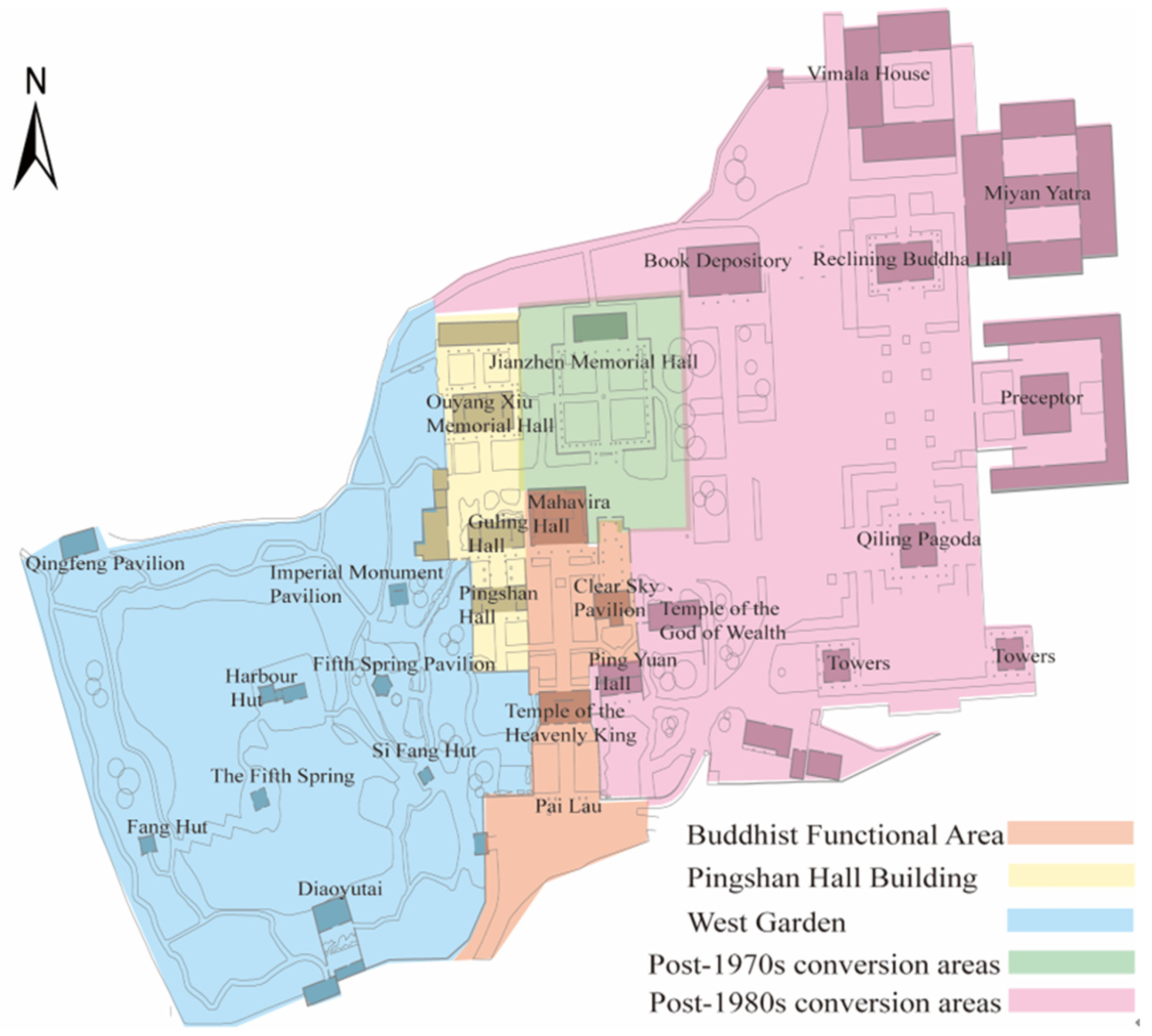
2.1. Study Site

Daming Temple (119.41° E, 32.42° N) is one of the eight famous monasteries in Yangzhou City, China, which was built during 457–464 A.D. Monk Jianzhen (688–763 A.D., also known as ‘Ganjin’ in Japanese), the host of the Daming Temple, had once traveled eastward to Japan and built the Tōshōdai-ji Temple, which significantly accelerated the communication of Mahayana Buddhism culture between China and Japan. Daming Temple has been expanded several times. In the Sui Dynasty, Emperor Yang Jian built the Qiling Pagoda in Daming Temple. During the Northern Song Dynasty, some literati contributed to the design and construction of the temple, e.g., the literatus Ouyang Xiu (1007–1072 A.D.) designed the residence Pingshan Hall in the temple; Su Shi (1037–1101 A.D.), the well-known writer, calligrapher, and painter, designed and constructed the residence Guling Hall next to Pingshan Hall. During the reign of Qianlong (1736–1796 A.D.) in the Qing Dynasty, Wang Yinggeng (1680–1742 A.D.), a well-known merchant, built the West Garden in the temple, which was praised by Emperor Qianlong for its scenery. Referring to historical records and ancient literature [18], there was no noticeable change in the spatial layout of the Daming Temple from the end of the Qing Dynasty to 1962. From 1962 to 1973, Jianzhen Memorial Hall by the temple was designed and constructed, which dramatically affected the spatial layouts of the temple garden. After the 1990s, Daming Temple expanded the East District and the West Garden while changes in its spatial layout occurred. Since the 1990s, the financial revenue of the temple has been increasing rapidly for the redevelopment of tourism; thus, the temple’s income has been able to cover the large-scale maintenance since the 2010s.
Daming Temple (Figure 1) is a typical representative of a re-activated Buddhism temple in China, which has undergone long-term alterations and expansions. There is an urgent need to study the building space of the Damien Monastery in order to advocate for the conservation and redevelopment of the temple’s heritage. Historical maps of 3 periods of Daming Temple were selected respectively, considering the changes in new-built areas, i.e., the construction of Jianzhen Memorial Hall and the expansion of the East District since the 2000s.

2.2. Methods of Quantitative Estimation

In the space syntax theory, the spatial structure analysis should focus on the ‘spatial configuration’, i.e., a set of complex relationships between spaces, all of which are interrelated in a global spatial structure. Spatial configuration can be visualized quantitatively by typical models, i.e., angular segment analysis (ASA), visibility graph analysis (VGA), and agent-based analysis (ABA). These models can reveal the comparability of measures of spatial configuration between different periods of space. The ASA model uses ‘angular distance’ rather than ‘metric distance’. The ‘angular distance’ can represent the visitors’ psychological and cognitive distance, such as the psychological distance expectation when they pass the steps. The visibility graph analysis (VGA) model in the space syntax system has also been widely adopted in small-and medium-scale spatial studies. As the temple heritage space has been redesigned several times, the structure of the space has changed accordingly. It is, therefore, necessary to visualize the spatial changes quantitatively. In typical Asian temple spaces, the levels of visibility and accessibility are often out of alignment, which can only be represented in the VGA model rather than the ASA model. Therefore, the study involves some parameters and indices in 2 space syntax models mentioned above, which are introduced as follows.
Some indices are commonly used in the ASA and VGA model, including ‘Mean depth’ (MD), normalized angle integration (NAIN), normalized angle choice (NACH) [19], and connectivity. In the space syntax system, ‘depth’ is the selected from the system or the amount of space passed through a given starting point. The MD value of a system is the average of all possible steps from a given starting point [20]. Angular segment integration (int.) shows how well each segment is integrated with all other segments, i.e., the total number of directional changes [21]. Angular choice shows the degree of integration of each segment of the path in terms of the lowest total number of angular deviations compared to all other segments. The angular choice analysis shows the potential for through movement in the spatial system [22].
Visual graph analysis (VGA) is a method for evaluating the inter-visibility of spaces. It builds upon the logic of an isovist analysis; it is different in that a visual graph analysis is derived from all the roots of each isovist field from each cell on a given raster. The VGA is applied at eye level (what people can see) and at knee level (where people can move) [23].
In both the ASA and VGA models, the value of connectivity is determined by the number of knots connected to the knot [24], calculated by Formula (1).
M D i = j = 1 n d i j n 1 , i j
where n—amount of knot in the system; d i j —the shortest topological distance between any two points.
The MD value in the VGA model can also be further converted to obtain an ‘integration’ index. The MD metric is often utilized to express the spatial configuration quantitatively. The ‘Connectivity’ (con.) index is a static local measure and explains the number of connections that each segment has to its direct neighboring ones. The ‘Mean connectivity’ (mean con.) index is defined as the average of the connection values of all nodes in the global space [25].
In the ASA model, NACH and NAIN are also adopted in accordance with methods put forward by Hiller et al. [26]. The values of NAIN and NACH can be calculated by Formulas (2) and (3).
N A I N i = n 1.2 / j = 1 n 1 d i j , i j
N A C H i = log σ s , t i / σ s , t + 1 log j = 1 n d i , j + 3 , i j
where n is the total knot amount; d is the shortest distance between point i and point j.
The ‘Intelligibility’ index is an indicator of the correlation between the local and the whole in a spatial system. Relevant empirical studies [26] have shown that the intelligibility of space is higher, and visitors will not easily get lost in space, and vice versa. The ‘Intelligibility’ index can be calculated by the Formula (4).
R 2 = C i C ¯ I i I ¯ 2 C i C ¯ 2 I i I ¯ 2 , i j
where C ¯ is the mean of all cell space connectivity values; I ¯ is the mean of all cell space global integrations.
‘Configurational centrality’ in spatial syntax is a concept used to describe the degree to which a particular location in a built environment is centrally located in relation to other locations within that environment. It is based on the idea that the spatial layout may affect the way visitors move through spaces [27,28].

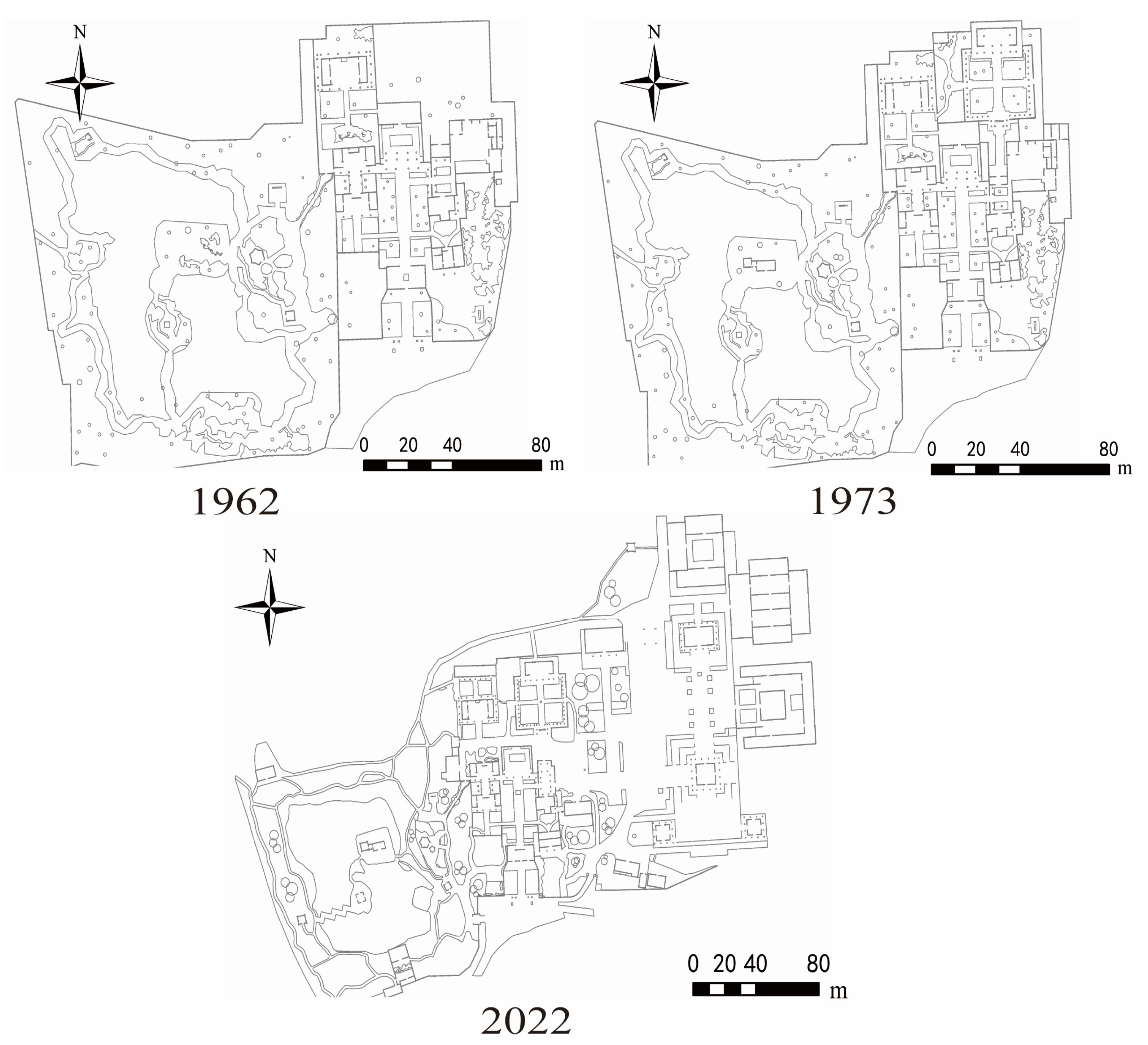
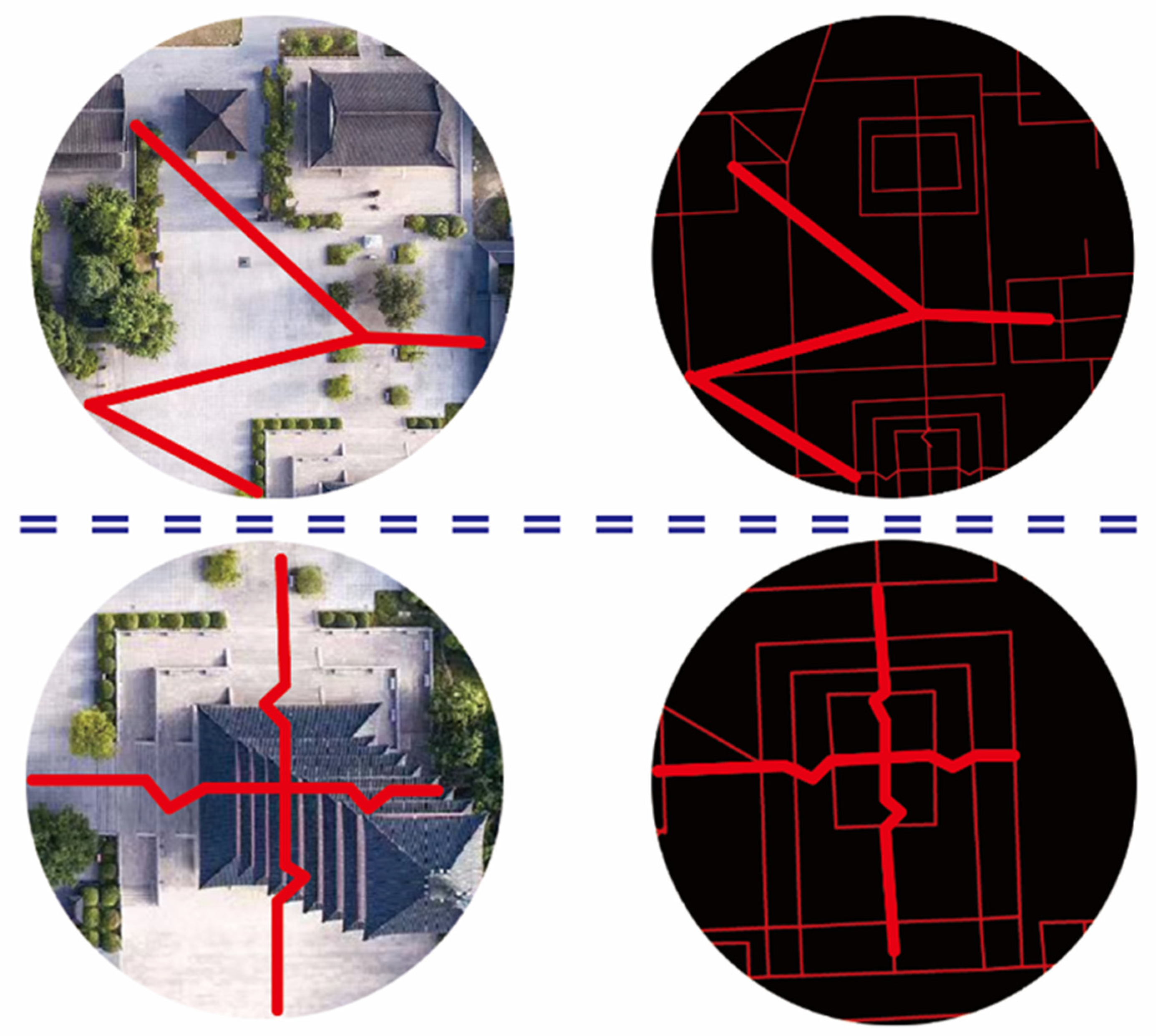
2.3. Preparation of the Data

Two-dimensional plan maps of the Daming Temple in 3 periods are adopted in the study, i.e., two historical maps drawn by scholars Congzhou Chen (1918–2000 A.D.) of Tongji University in the 1960s and the 1970s and CAD maps drawn during the in situ survey conducted in 2022 by the Cultural Publicity Department of the Daming Temple, Jiangsu Province. To ensure the precision of the mapping, a short-term in situ survey was also conducted. Then, 3 versions of the survey map (Figure 2) were re-drawn in the software Rhinoceros 7 (a multi-functional parametric modeling software developed by Robert McNeel & Associates, Seattle, WA, USA) and input into the software DepthMap 1.0+ Beta (software developed by University College, London, UK). Some necessary manual modifications were performed based on the on-site mapping. During the movement of the visitors in the space, most of the space is relatively flat, with only a small difference in height between the articulated parts of the attraction and the attraction. These heights have little impact on the visitor’s views; therefore, there is little potential to affect the accuracy of the VGA model. Simultaneously, in the ASA model, we used polylines based on the principles of modeling from a spatial syntax perspective, as described later.
In the VGA model, the temple heritage space is transformed into a 2D grid system of 0.8 × 0.8 m for the width of 0.8 m, approximately the width of a person’s shoulder. The amounts of elements in the operation are simplified within the range that is acceptable for computation. ‘Accessible’ areas in this study are identified as those areas open to the public and can be visited freely most of the time, referring to the information provided by the Cultural Publicity Department of the Daming Temple, Jiangsu Province, and the in situ survey. In addition, spatial elements are processed with the method explained in Table 1. The drawing principle of elements is considered according to the significance of impacts on the viewshed model per se by elements (Table 1).
As for the ASA model, it is commonly idealized that visitors often act as ‘embodiment’ in spaces with various forms, which leads to their diverse behavioral patterns of pathfinding [29]. The ‘revised’ distance that fits the perception pattern of the visitor is defined as the ‘psychologically shortest expected path’, which represents the psychologically expected distance perception of the visitors in spatial systems. It is noticed that visitors are often willing to walk through paths with the shortest Euclidean distance in the barrier-free spaces; otherwise, once visitors perceive the fact that there are spatial barriers (e.g., stone steps) exist in the space ahead, their ‘psychologically minimum expected distance’ will firmly increase. Therefore, visitors’ sensory perception should be considered for the ASA model. A special modeling approach is used for the wide area of the East District in this study.
Some key drawing principles in the practical modeling process are applied (Figure 3) to enable the model to reflect visitors’ psychological costs. Firstly, considering those areas with stairs, the polyline segments with angle change are used to represent the psychological distance expectation. Secondly, for the distinctive spatial differences between the newly built East District and other spaces, the widths of those new-built spaces are relatively larger; thus, the visitors’ behavioral preferences are often affected by seeking paths with the shortest Euclidean distance when then walking through the space. Thus, the square spaces are represented by diagonals.

3. Results

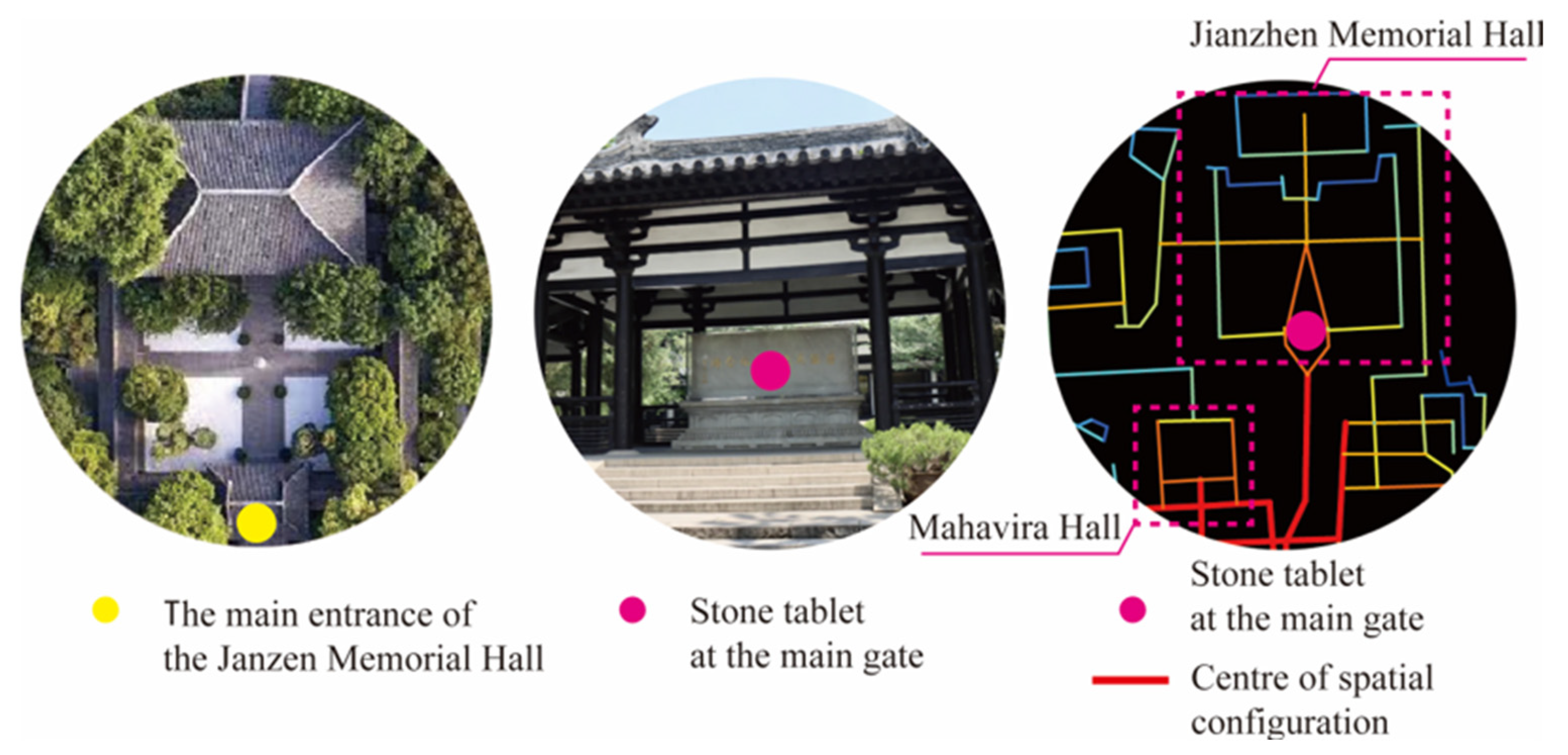
3.1. Changes in the Center of Spatial Configuration

Both the ASA and VGA models are used in this study to investigate the change in the center of the spatial configuration of the temple. The ASA model is based on the simplified accessibility network, while the VGA model is used to represent the coincidence and separation of the visual and accessible spatio–temporal structures.
In the VGA model, constructed using the software DepthMap 1.0, the MD values are visualized (Figure 4). As for the knee-level layer in 1962, the area with the highest 10% integration value is located in the Main Hall and its front area, while the area with the highest 10% integration value in the eye-level layer has a high similarity with those in the knee-level layers. In 1973, there was no obvious change in the integration value of each part of the space, although a new architecture, Jianzhen Memorial Hall, was built. The position of the center of the spatial configuration in the system does not change noticeably. In 2022, the area with the highest 10% accessibility is located in the wide area of the east side of the temple architecture, while the area with the lowest 10% accessibility is located in the West Garden. It can be seen that the Main Hall had a higher level of accessibility in the area before the construction of the East District. After the redesign and expansion of the East District, we observe that the center of spatial configuration was shifted to the eastern side, indicating that the topological priority of the Main Hall was gradually replaced by the East District. In 2022, the East District turned into a more accessible place eventually.
In the ASA models, some key space syntax indices, e.g., integration, connectivity, and intelligibility, are believed to be competent for measuring the quality of space [30]. An ASA model is generated by the software DepthMap 1.0 (Figure 5), in which the center of accessibility is bolded for high-clarity visualization, and 200 m-radius integration and global integration are calculated, respectively. The values are visualized in reversed pseudocolor, i.e., reddish hue for lower values while bluish hue for higher values. Comparing the results by NAIN and VGA analysis, typical patterns of their spatial configuration are found. Some differences are noticeable. In 2022, the distribution of NAIN values presented that the higher-valued area is the path between Mahavira Hall and Qiling Pagoda, where the NAIN values of these sites are noticeably different from their surroundings. These phenomena above do not present any statistical inconformity with the findings in the VGA model.
The ASA model is further utilized in studying the variations of the center of the temple during internal spatio–temporal structural changes in chronological order. Considering the distribution of NACH in different periods (Figure 6), some phenomena are highlighted as follows. Similar to the evolution of the center of accessibility, the traversal center also conducted a process of centrality shift, transferring from east to west. The existing center of accessibility presented a lower influential effect in local spaces, whereas the original traversal center still maintains a high probability of being accessed by visitors. Although the space near Mahavira Hall has decreased accessibility, it still plays an important role in the local space of the circulation of visitors. Meanwhile, the center of the entire space also tends to transfer toward the East District.

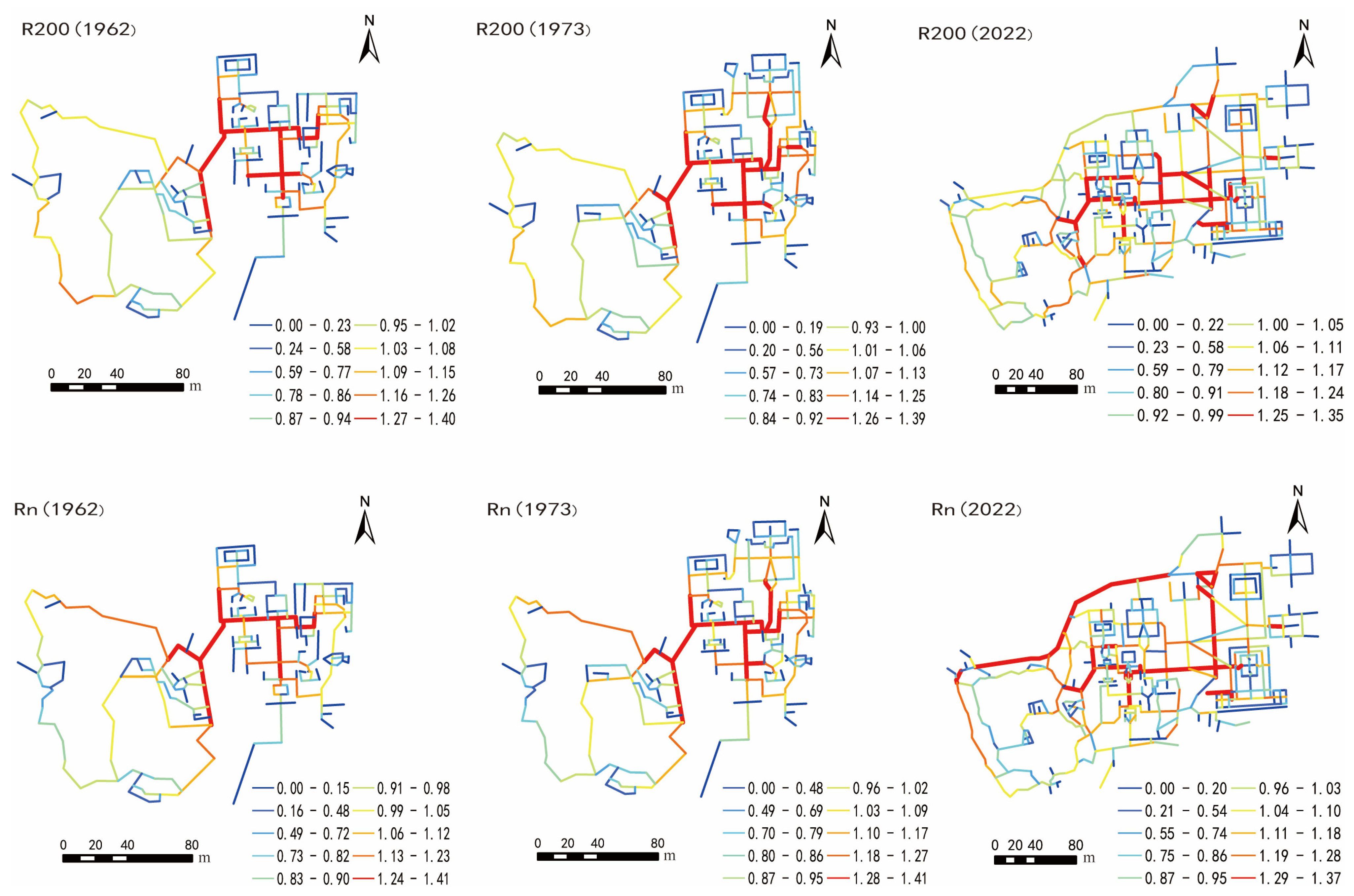
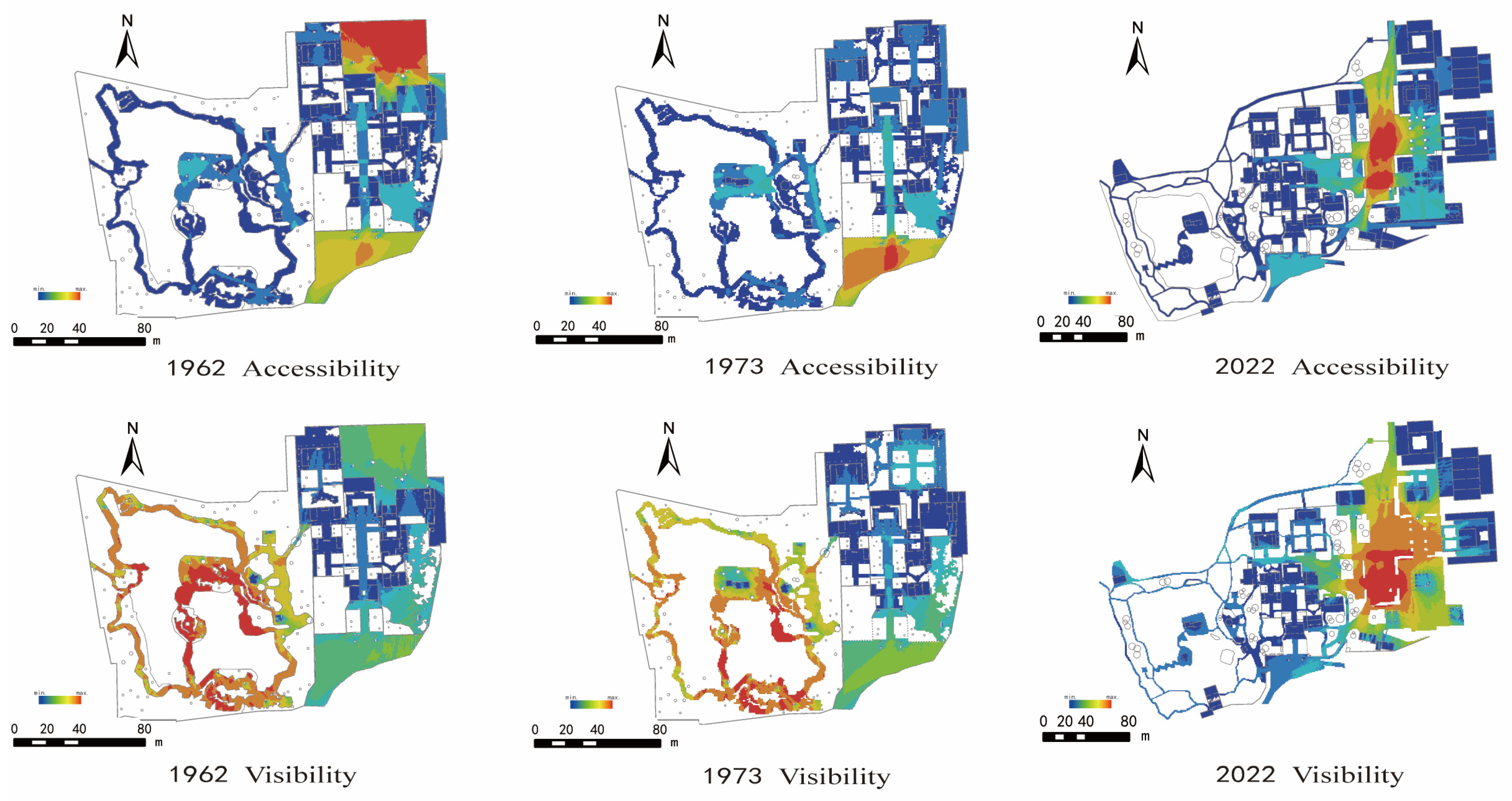
3.2. Changes in Interrelationships among Local Spaces

We further explore the changes in the specific relationship of ‘temple-residence-garden’ in the process of spatio–temporal changes in the temple heritage to summarize some highlighted findings. A quantitative estimate of the MD values is calculated by Formula (1) given in Section 2.2. in the DepthMap software. In 1962, the MD values of the West Garden (5.25–17.67), Pingshan Hall (5.26–8.95), and the Main Hall (4.75–6.26) were lower than the average value of the global MD. The global influence effect of the West Garden is not significant, while the MD value of the West Garden fluctuates, which may indicate that variations in accessibility are noticeable in hierarchical orders [31]. The MD values of both knee level and eye level in 1973 were lower than those observed in the 1962 model, but the hierarchical relationship of the topological space system did not occur in qualitative variations.
For the knee-level layer in 2022, the MD value of the Main Hall (4.20–5.51) approximates the MD of the global spatial system (4.23–5.42). The accessibility of the Main Hall is decreasing year by year; otherwise, the MD value of Pingshan Hall (4.93–7.78) is still remarkably higher than that of the Main Hall. The MD value of the West Garden (4.33–16.84) is higher than that of the global MD, indicating that the hierarchical order of accessibility in the West Garden is weakened. At eye level, the accessibility of the West Garden and Pingshan Hall is also approximate, and the accessibility of religious space and architecture (i.e., the Main Hall) is higher than that of these areas dominated by semi-natural landscapes (i.e., the West Garden and Pingshan Hall).

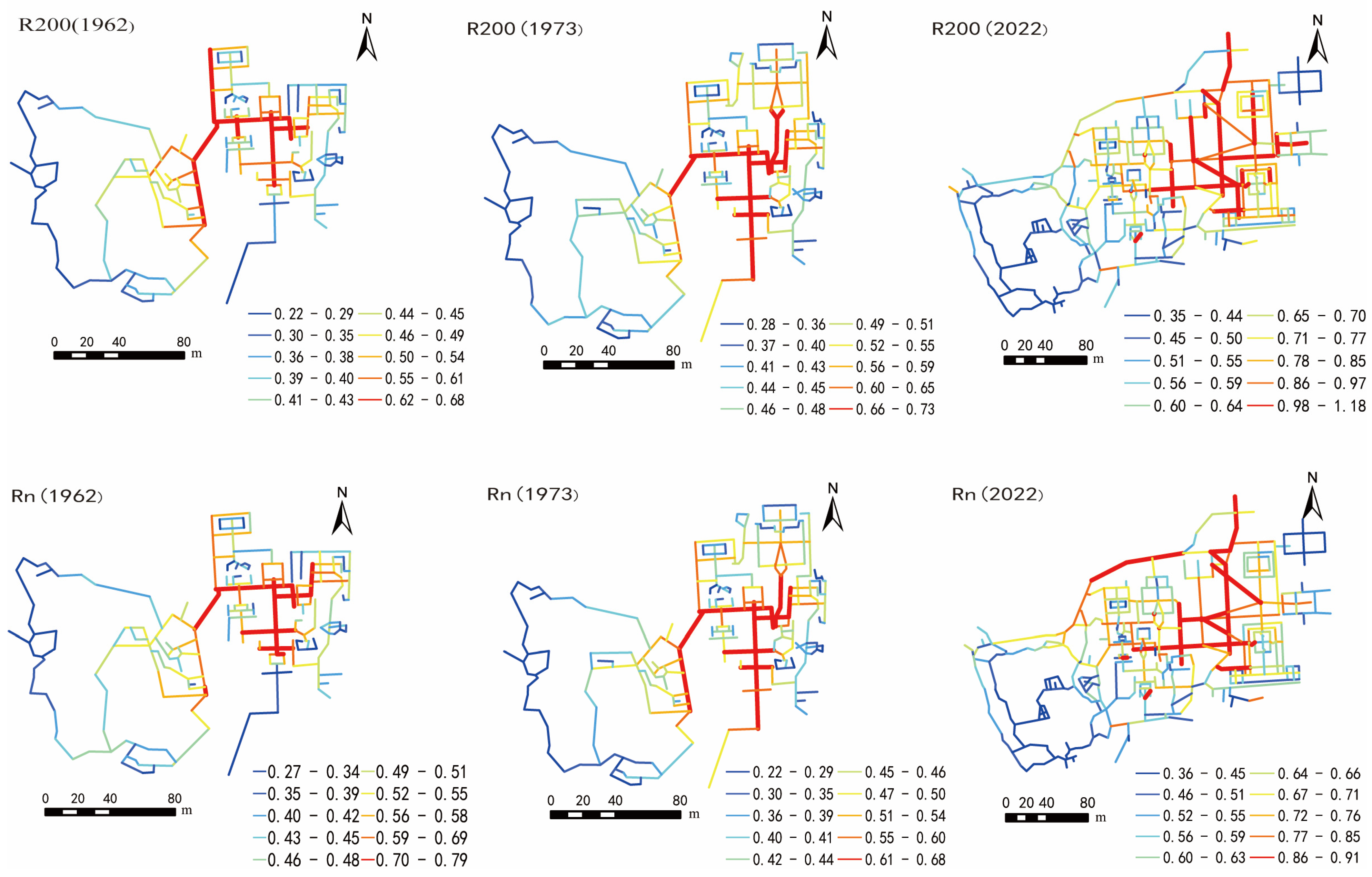
3.3. Changes in Spatial Connectivity

The ‘connectivity’ index in the VGA model can reflect visitors’ recognition of the space. By the analysis of the eye-level connectivity in 1962 (Figure 6), values of the mean con. of Mahavira Hall (502.59), Pingshan Hall (228.56), and Guling Hall are calculated, whereas the mean con. of The West Garden (3570.83) is much higher than the global average value. As for the knee-level connectivity, the mean con. values of the West Garden (247.08) were less different from those of other architectures in 1962. In 2022, both knee-level and eye-level connectivity of the new-built East District were noticeably higher than elsewhere; however, the relationship between existing spaces has not changed. Compared with the changes in spatial connectivity among the three periods, the perception of the spaces surrounding the architecture and garden was very close before the redesign and reconstruction of the East District, while the visual perception of the architecture is relatively closed. The visual space permeability of the West Garden is the highest, with visions of higher openness.

3.4. Changes in Spatial Intelligibility

After the redesign and construction of the East District since the 2000s, the form and configuration of the global space have observed to undergone certain changes, which may affect the activities of visitors. In the space syntax theory, ‘intelligibility’ is a parameter for the evaluation of difficulties the visitor will suffer in understanding geographical positions in the global space, and the complexity of spaces can be calculated based on the MD value of the local and global spaces [32]. Results attained in the former steps are used for regressive calculation of the intelligibility, with connectivity as the x-variable and NAIN as the y-variable (Table 2). By a Python program developed with the package matplotlib for quantitative statistics, the goodness-of-fit (R2) parameter is calculated. R2 has a value range of [0–1]. The closer R2 to 1, the higher the intelligibility, and vice versa. It is seen that the global ‘intelligibility’ values are consistently low, which indicates that the probability of getting lost in the space is higher for visitors, which can be explained by its unique ‘temple–residence–garden’ spatial structure.
Quantitative estimation of the MD values in the VGA model is calculated by Formula (1) in the DepthMap software (Table 3). The higher the MD value, the higher the average number of turns it would take visitors to pass through the space; in other words, the space is relatively more complex. We observed that the visual-spatial structure of the temple heritage in different periods keeps relatively simple. On average, at least two turns of the visitor’s movement can enable them to take a global visual perception of almost all spaces in the study site. The reason for changes in visitors’ paths is explained as follows. The structure of accessible space distribution is found to be of high complexity, requiring visitors to make at least six turns to pass through the heritage space in both 1962 and 1973. However, after the reconstruction of the East District, the scale of the Daming Temple increased. There are at least four turns needed for visitors to pass through the temple in 2022. making it easier for visitors to perceive the global structure of the space, which is likely to be effective for the revitalization of the temple as well as the development of tourism [33]. Simultaneously, with the expansion of the East District, the scale of the temple has been increased, making it more efficient and encouraging visitors to perceive the global topological structure of attractive spaces. Therefore, it has a certain positive significance for the heritage revitalization and tourism development of the temple.

4. Discussion

4.1. Explanations of Changes in the Spatial Structure

From the statistics, we found that the centrality of the spatial structure of the temple was relatively stable, whereas the topological structure has been changing greatly since the 1990s, during which the center of accessibility has been gradually transferred toward the East District. In addition, decreasing MD value presents the development of tourism planning and construction of the temple. Otherwise, Mahavira Hall always remains its spatial–topological priority among the global spaces, which indicates that the religious functionalities of the temple have presented a ‘guidance’ effect on spatial–topological transformations [34]. The religious-functional architecture in the existing spaces of the temple during the three periods have shown their distinguished significant influences on the spatial form, while Pingshan Hall and the West Garden present low spatial influential effects but a higher level of integration.
Moreover, the traditional spatial layout of the existing scenic sites of the temple is appropriately well-preserved, for sustainable strategies for building heritage conservation have been applied, i.e., protecting the ancient temple building and expanding the new-built scenic areas simultaneously. The spatio–temporal changes in the spatial system are typical temporal processes that offer quantitative records of the dynamic developments of the temple [35]. These records are of help for those individual visitors to perceive the historical memory of the space, which is believed to be effective for the reactivation of cultural heritage.

4.2. Explanations of Changes in Temporal–Spatial Connectivity

As for the spatial design of the Daming Temple in different periods, spaces with different characteristics were rearranged several times, which contributed to the creation of complex spaces with a deep sense of closure-openness interrelationships [36]. These interrelationships transform the spaces surrounding the architecture into more closed and enclosed forms, and the spaces surrounding the garden have maintained a high degree of openness. These phenomena can be explained as follows:
In ancient times, the small-scale architecture in temples was designed for Zen meditation by monks, and the huts surrounding the garden were designed for the lord of the manor to entertain guests, i.e., writers and painters. Therefore, the spaces around the small architecture and the huts tend to be more ‘dynamic’ in the topological network, facilitating activities such as literary gatherings. In contrast, the West Garden was designed as an attractive space to enjoy the landscape, so the garden is more ‘static’. The contradictions between these spaces highlight the functional differences between architectural and garden spaces [37]. Furthermore, the temporal connectivity at both eye and knee level in the West Garden is also confirmed to be quite different, which is believed to be induced by the design of the unique spatial structure and abundant landscaping elements. These design techniques have also been shown to be effective in creating mysterious aesthetic experiences for visitors, as noted in a similar study [38].

4.3. Explanations of Spatial Changes in Specific Scenic Areas

Although the center of spatial configuration has constantly been shifting, it was found that the original center of accessibility with higher MD values was constantly located around Mahavira Hall. As a result of this phenomenon, the global spatial structure and geographical features were well understood by visitors, which eased their pathfinding difficulties even in extremely complex spatial systems [39]. The spatial design methods used in Jianzhen Memorial Hall and Baoben Hall (Figure 7) have proven to be dramatically effective in increasing the visitors’ visual perceptions. When visitors walk around the center of accessibility, they can easily find Jianzhen Memorial Hall. At the same time, the pavilion at the main entrance blocks visitors’ view into the spaces. These spatial design methods can skilfully guide visitors to perceive the spatial structure and precept the excessive ‘in-between’ senses along their routes.
In terms of the practical design, the detailed design of the East Garden makes flexible use of in situ topographic conditions. The new-built East District has not affected the connectivity of the temple; otherwise, the spatial enclosure of the existing and new-built scenic sites in the space is remarkably dynamic.
The perception of physical activity areas and visual perception of knee-level and eye-level accessibility in the West Garden during the three periods are quite different, which presented the ‘visual perception’ characteristics of temple gardens. In addition, the existing temple garden space has a complex structure that allows visitors to perceive the unique and profound spatial structure.

4.4. Further Discussions

Further discussions of this study are concluded as follows. Among them, several comparisons between other space-syntax-based projects and this study are present, which should be noticed for other homogeneous studies in the future.
(1)
The study adapts the methodological integration of two sets of space syntax models, i.e., the ASA and the VGA model. It is indicated that both models can be used simultaneously to better express the internal temporal–spatial characteristics of ancient temple garden design. However, the efficient framework and workflows in real-time modeling environments have not been developed for these methodologies, which is potential for further studies.
(2)
The study tried to expand the scale of spatial studies by the quantitative approach, and some useful applications of space syntax have been applied to the typical ancient temples. However, the case study in this research mainly focuses on horizontal spatial relationships among building and landscape elements, while vertical temporal relationships and spatial interaction [40] have not been abundantly considered, which has the potential to be improved.
(3)
The visualization in this study illustrates how the design of the building space enables visitors to clarify the complex structure of the space through the temporal–spatial center of connectivity and global intelligibility. Otherwise, some other indices may be developed for more specific estimations in the future.
(4)
Although some conservative opinions believe that only a limited number of fragmented spaces can be redesigned to surround the existing historical buildings, recent studies believe that the redesign, reactivation, and redevelopment project of historical and cultural spaces should be conducted considering the overall spatio–temporal space, as mentioned in similar studies [41,42]. In the process of spatial redesign, reconstruction, and reactivation of the temple, conservation, and development are not in a dichotomy; otherwise, there is a connection between existing and new-built spaces, which often reveals profound spatio–temporal characteristics of the space. Thus, related professional scholars of urban design, landscape architecture, environmental design, geography, etc., should further study the internal spatial characteristics of spaces in the future.

5. Conclusions

This study aims to elucidate the spatio–temporal characteristics of a typical ancient temple in different historical periods through two spatial syntax models. The causal mechanisms between spatial design and spatial configuration are revealed quantitatively. It is convinced that the original hierarchical relationships among the temple buildings remained almost unchanged during the three periods. After the redesign and reconstruction, the centrality of the spatial composition of the temple has been shifting to the east, while the topological characteristics of some specific spaces have dramatically increased. Different local spatial functionalities are proved to be well arranged in the developments of the temple’s construction, which creates an aesthetic experience for visitors through the closure-openness contrast in both eye level and knee level. The previously existing center of spatial configuration has been extended to the other local spaces, allowing visitors to easily comprehend the global spatial configuration. We found that the spatio–temporal changes had an impact on visitors’ itineraries in the temple heritage. Overall, the research provides theoretical foundations and suggestions for sustainable conservation, redesign, reactivation, and management of typical temple spaces, while further relative studies can be conducted to improve the applicability of the spatial syntax models in further studies.

Author Contributions

Conceptualization, X.D. and K.Z.; methodology, X.D. and K.Z.; software, K.Z. and T.L.; resources, W.W. and T.L.; writing—original draft preparation, K.Z. and T.L.; writing—review and editing, W.W. and X.D.; visualization, K.Z. and T.L. All authors have read and agreed to the published version of the manuscript.

Funding

This research was supported by the National Natural Science Foundation of China (project #52278083) and the Ministry of Education Humanities and Social Sciences Research Planning Fund (project #18YJAZH103).

Institutional Review Board Statement

Not applicable.

Informed Consent Statement

Not applicable.

Data Availability Statement

All relevant data are included in the paper.

Conflicts of Interest

The authors declare no conflict of interest (including appropriate disclosures).

References

  1. Turner, T. Asian Gardens: History, Beliefs and Design; Routledge: London, UK, 2010. [Google Scholar]
  2. Wang, X.; Zhu, H.; Shi, Y. The Cognitive Mechanisms and Characteristics of Isomorphic Synesthesia of Chinese Classical Garden. Chin. Landsc. Archit. 1999, 4, 61–62. [Google Scholar]
  3. Li, X.; Xia, B.; Lusk, A.; Liu, X.; Lu, N. The Humanmade Paradise: Exploring the perceived dimensions and their associations with aesthetic pleasure for Liu Yuan, a Chinese classical garden. Sustainability 2019, 11, 1350. [Google Scholar] [CrossRef]
  4. Zheng, Y.; Wei, W.; Zhang, L.; Ying, T. Tourist Gaze at Chinese Classical Gardens: The Embodiment of Aesthetics (Yijing) in Tourism. J. Hosp. Tour. Res. 2022. [Google Scholar] [CrossRef]
  5. Zhang, T.; Lian, Z. Research on the Distribution and Scale Evolution of Suzhou Gardens under the Urbanization Process from the Tang to the Qing Dynasty. Land 2021, 10, 281. [Google Scholar] [CrossRef]
  6. Karimi, K. Space syntax: Consolidation and transformation of an urban research field. J. Urban Des. 2018, 23, 1–4. [Google Scholar] [CrossRef]
  7. Hegazi, Y.S.; Tahoon, D.; Abdel-Fattah, N.A. Socio-spatial vulnerability assessment of heritage buildings through using space syntax. Heliyon 2022, 8, e09133. [Google Scholar] [CrossRef]
  8. Bafna, S. Space syntax: A brief introduction to its logic and analytical techniques. Environ. Behav. 2003, 35, 17–29. [Google Scholar] [CrossRef]
  9. Hiller, B. The Common Language of Space: A Way of Looking at the Social, Economic and Environmental Functioning of Cities on a Common Basis. J. Environ. Sci. 1999, 3, 344–349. [Google Scholar]
  10. Dettlaff, W. Space syntax analysis–methodology of understanding the space. PhD Interdiscip. J. 2014, 1, 283–291. [Google Scholar]
  11. Eldiasty, A.; Hegazi, Y.S.; El-Khouly, T. Using space syntax and topic to evaluate the conservation of urban heritage sites for possible UNESCO listing the case study of the historic centre of Rosetta, Egypt. Ain Shams Eng. J. 2021, 12, 4233–4245. [Google Scholar] [CrossRef]
  12. Moonkham, P.; Duff, A.I. The social logic of the temple space: A preliminary spatial analysis of historical Buddhist temples in Chiang Saen, Northern Thailand. Int. J. Hist. Archaeol. 2022, 26, 849–884. [Google Scholar] [CrossRef]
  13. Saraoui, S.; Attar, A.; Saraoui, R. Considering luminous ambiance and spatial configuration within the ottoman old heritage buildings (Algerian Palaces) focusing on their modern-day utility. J. Cult. Herit. Manag. Sustain. Dev. 2022, 15, 27–54. [Google Scholar] [CrossRef]
  14. Susnow, M. The space syntax of Canaanite cultic spaces: A unique category of spatial configuration within the bronze age southern levant. Bull. Am. Sch. Orient. Res. 2021, 385, 131–152. [Google Scholar] [CrossRef]
  15. Jia, S.; Liao, Y.; Xiao, Y.; Zhang, B.; Meng, X.; Qin, K. Conservation and management of Chinese classical royal garden heritages based on 3D digitalization—A case study of Jianxin courtyard in Jingyi garden in fragrant hills. J. Cult. Herit. 2022, 58, 102–111. [Google Scholar] [CrossRef]
  16. Zhang, T.; Tang, G.; Lian, Z. The mathematics of spatial structure evolution: Using syntactical data to compare the Humble Administrator’s Garden in the sixteenth and nineteenth centuries. Nexus Netw. J. 2023, 1, 1–21. [Google Scholar] [CrossRef]
  17. Xu, Y.; Rollo, J.; Jones, D.S.; Esteban, Y.; Tong, H.; Mu, Q. Towards sustainable heritage tourism: A space syntax-based analysis method to improve tourists’ spatial cognition in Chinese historic districts. Buildings 2020, 10, 29. [Google Scholar] [CrossRef]
  18. Guo, Q. Development trend of the architectures with Chinese characteristics under the impact of western culture. In Proceedings of the International Conference on Education, Management and Computing Technology (ICEMCT-15), Tianjin, China, 13–14 June 2015; pp. 66–170. [Google Scholar]
  19. Hillier, B.; Yang, T.; Turner, A. Normalising least angle choice in DepthMap and how it opens new perspectives on the global and local analysis of city space. J. Space Syntax 2012, 3, 155–193. [Google Scholar]
  20. Hillier, B. Centrality as a process: Accounting for attraction inequalities in deformed grids. Urban Des. Int. 1999, 4, 107–127. [Google Scholar] [CrossRef]
  21. Wu, L.W.; Guo, S.J. An application of space syntax to critical working space analysis: The case of building construction. J. Mar. Sci. Technol. 2014, 22, 6. [Google Scholar]
  22. Hillier, B.; Iida, S. Network effects and psychological effects: A theory of urban movement. In Proceedings of the 5th Space Syntax 5th International Symposium, Delft, The Netherlands, 13–17 June 2005. [Google Scholar]
  23. Turner, A.; Doxa, M.; O’Sullivan, D.; Penn, A. From isovists to visibility graphs: A methodology for the analysis of architectural Space. Environ. Plan. B 2001, 28, 103–121. [Google Scholar] [CrossRef]
  24. Zaleckis, K.; Dogan, H.A.; Arce, N.L. Evaluation of the Interventions to built heritage: Analysis of selected facades of Kaunas by space syntax and sociological methods. Sustainability 2022, 14, 4784. [Google Scholar] [CrossRef]
  25. Hillier, B.; Hanson, J. The Social Logic of Space; Cambridge University Press: Cambridge, UK, 1984. [Google Scholar]
  26. Ramadhan, T.; Septian, L.H.; Nurdini, A. Housing Morphology and Connectivity Quality in Periphery of Bandung City: Space Syntax Analysis. KnE Soc. Sci. 2019, 3, 470–484. [Google Scholar] [CrossRef]
  27. Penn, A. Exploring the frontiers of space: Bill Hillier (1937–2019). Urban Morphol. 2020, 24, 224–229. [Google Scholar] [CrossRef]
  28. Sharmin, S.; Kamruzzaman, M. Meta-analysis of the relationships between space syntax measures and pedestrian movement. Transp. Rev. 2018, 38, 524–550. [Google Scholar] [CrossRef]
  29. Conroy-Dalton, R.; Hoelscher, C. Understanding Space: The nascent synthesis of cognition and the syntax of spatial morphologies. In The Proceeding of Space Syntax and Spatial Cognition; Conroy-Dalton, R., Hoelscher, C., Turner, P.A.F., Eds.; Springer: Berlin/Heidelberg, Germany, 2006. [Google Scholar]
  30. İmran, G.; Etike, B.A.; İstem, S. The comparative analysis of space syntax and PPS approaches in measuring quality of urban space: The case of Beyazit district, Istanbul. Megaron Yıldız Tech. Univ. Fac. Archit. E-J. 2022, 17, 437–448. [Google Scholar]
  31. Al Naim, M.M. Dwelling form and culture in the traditional Najdi built environment, Saudi Arabia. Open House Int. 2021, 46, 595–614. [Google Scholar] [CrossRef]
  32. Zhang, L.; Chiradia, A.; Zhuang, Y. In the intelligibility maze of space syntax: A space syntax analysis of toy models, mazes and labyrinths. In Proceedings of the Ninth International Space Syntax Symposium, Seoul, Republic of Korea, 31 October–3 November 2013; Available online: http://www.sss9.or.kr/paperpdf/scb/sss9_2013_ref082_p.pdf (accessed on 19 April 2017).
  33. Yu, R.; Gu, N.; Ostwald, M. The mathematics of spatial transparency and mystery: Using syntactical data to visualise and analyse the properties of the Yuyuan Garden. Vis. Eng. 2016, 4, 4. [Google Scholar] [CrossRef]
  34. Piyawit, M.; Nattasit, S.; Andrew, D. The heterarchical life and spatial analyses of the historical Buddhist temples in the Chiang Saen Basin, Thailand. J. Anthropol. Archaeol. 2023, 70, 101506. [Google Scholar]
  35. Feng, B.; Ma, Y. Network construction for overall protection and utilization of cultural heritage space in Dunhuang City, China. Sustainability 2023, 15, 4579. [Google Scholar] [CrossRef]
  36. Tceluiko, D.; Bazilevich, M. Space syntax: Mathematical analysis of traditional Chinese private gardens planning structures. IOP Conf. Ser. Mater. Sci. Eng. 2018, 463, 022033. [Google Scholar] [CrossRef]
  37. Pramanik, S. Accessibility and visibility through space syntax analysis of the Linga Raj Temple in Odisha, India. In Proceedings of the International Conference on History and Theory of Architecture, Zurich, Switzerland, 6 November 2020. [Google Scholar] [CrossRef]
  38. Dai, X.; Luo, C.; Chen, X. The Creation of Complexity in Chinese Garden. Appl. Mech. Mater. 2012, 209–211, 380–383. [Google Scholar] [CrossRef]
  39. Liao, P.; Yu, R.; Gu, N.; Soltani, S. A syntactical spatio-functional analysis of four typical historic Chinese towns from a heritage tourism perspective. Land 2022, 11, 2181. [Google Scholar] [CrossRef]
  40. Batty, M. Integrating space syntax with spatial interaction. Urban Inform. 2022, 1, 4. [Google Scholar] [CrossRef]
  41. Susnow, M.; Goshen, N. House of a king, house of a god? situating and distinguishing palaces and temples within the architectonic landscape of the middle and late bronze age southern levant. Levant 2021, 53, 69–91. [Google Scholar] [CrossRef]
  42. Li, Z. Visual perception of traditional garden space in Suzhou, China: A case study with space syntax techniques. In Proceedings of the 2011 19th International Conference on Geoinformatics, Shanghai, China, 24–26 June 2011. [Google Scholar] [CrossRef]
Figure 1. Two-dimensional map of spaces in the Daming Temple during different periods.
Buildings 13 01345 g001
Figure 2. Two-dimensional maps of Daming Temple in 3 different periods for VGA analysis.
Buildings 13 01345 g002
Figure 3. Detailed samples of key drawing principles in the ASA model.
Buildings 13 01345 g003
Figure 4. Visualized results of NAIN analysis in different periods.
Buildings 13 01345 g004
Figure 5. Visualized results of NACH analysis in different periods.
Buildings 13 01345 g005
Figure 6. Distribution of connectivity in different periods.
Buildings 13 01345 g006
Figure 7. Detailed design of Jianzhen Memorial Hall.
Buildings 13 01345 g007
Table 1. Principles for drawing spatial elements in the VGA model.
Spatial ElementsEffects on Circulation of Visitors (Yes/No)Knee-Level Model (Draw/Not Draw)Effects on the Viewshed (Yes/No)Eye-Level Model (Draw/ Not Draw)Detailed Explanations
WallYDrawYDrawOnly draw those walls and pavilions that block the paths and viewsheds.
PavilionYDrawYDraw
RockeryYDrawYDrawOnly draw those rockeries with heights ≥ 1.6 m.
ArborNNot drawYDraw
WindowYDrawNNot drawOnly draw those windows and doors that can be accessed or walked through.
Door/GateNNot drawNNot draw
ShrubNNot drawNNot drawIsolate-planted small vegetation is neglected.
LawnYDrawNNot draw
WaterscapeYDrawNNot draw
Table 2. Values of intelligibility in different periods.
IndicesTermNAIN (1962)NAIN (1973)NAIN (2022)
Intelligibility R400Goodness of fit (R2)0.2580.2520.230
Significance0.0000.0000.000
Table 3. Values of global MD in different periods.
YearArea of All Architectures (m2)Area of the West Garden (m2)Total Area (m2)MD Value (Eye Level/Knee Level)
196211,43117,41528,8467.54/3.55
197311,86117,41529,2767.46/3.47
202228,31018,71347,0235.23/2.36
Disclaimer/Publisher’s Note: The statements, opinions and data contained in all publications are solely those of the individual author(s) and contributor(s) and not of MDPI and/or the editor(s). MDPI and/or the editor(s) disclaim responsibility for any injury to people or property resulting from any ideas, methods, instructions or products referred to in the content.

