

Research on the Spatial Sequence of Building Facades in Huizhou Regional Traditional Villages

1
College of Civil Engineering, Hefei University of Technology, Hefei 230009, China
2
School of Architecture and Urban Planning, Anhui Jianzhu University, Hefei 230601, China
3
College of Architecture and Art, Hefei University of Technology, Hefei 230009, China
4
Division of Science and Technology, Anhui Jianzhu University, Hefei 230601, China
*
Author to whom correspondence should be addressed.
Buildings 2023, 13(1), 174; https://doi.org/10.3390/buildings13010174
Submission received: 10 December 2022
/
Revised: 2 January 2023
/
Accepted: 5 January 2023
/
Published: 10 January 2023
(This article belongs to the Topic Climate Change and Environmental Sustainability, 2nd Volume)
Abstract
:Under the influences of the regional environment, building communities within traditional villages exhibit regional styles and features. Based on the research team’s early studies, and given the protection and renewal practices of Huizhou traditional villages in Southern Anhui Province, China, this study investigated the spatial sequences of building facades and explicated the laws of these spatial sequences. This research involved a series of technical steps. First, in the case selection stage, typical traditional villages and spatial sequence paths were established. Second, in the data acquisition stage, 3D laser scanning technology was used to acquire building elevation data and conduct 3D modelling. Finally, the measurement indices were determined by vector analysis of the data. Factor analysis and cluster analysis were suitable for the reduction and classification of the above data in order to explore the constitution law of building units. Meanwhile, the regularity of the facade organization of building groups was further quantified by examining the combination and connection relationships between the building and spatial patterns. Then, the laws of facade organization of the building groups were explicated. The purpose of this study is not only to achieve accurate inheritance of historical data information, but also to explore the centralized contiguity mechanism behind the traditional villages through external features from the perspective of rescue. The results demonstrated that there are spatial sequences represented by building facades in Huizhou traditional villages. Moreover, internal laws of “largely identical but with minor differences” in the building unit composition and building group organization were identified. These findings: (1) provide a deeper understanding of the regional characteristics of Huizhou traditional villages in Southern Anhui Province, China; (2) offer a foundation for practical administration requirements; and (3) recognize a novel research perspective and a feasible technical route for the protection of traditional villages in other regions, with an appreciation for the value of spatial sequences.
1. Introduction
Regional traditional villages are widely distributed all over the world. When considering the concept of regional traditional villages, “regional” relates to the limitations of the local geography and local environment [1], while “traditional” relates to experiences, history and memories [2]. These two terms support each other. Because of the different regional conditions and traditional history, they have different styles and characteristics. For example, in some regions of Central and South America, houses with wide distances are formed due to fallow land, forming discrete settlements with loose forms [3]; in Iran, due to the topographic conditions of steep slopes, platform-roof settlements have been formed following the trend of desert [4]. Although the characteristics of each village and architecture are unique, the overall development process and value cognition process of traditional villages generally follow the common law.
From the perspective of development process, regional traditional villages are often defined as complicated systems that are produced by both spontaneous power and design power [5]. Spontaneous power occurs in the early stage when there is relatively low productivity. The adaptability of human to the natural environment determined that the development of traditional villages was often passive. The agricultural production mode [6], the infiltration of life and culture [7] and the restriction of ecological environment [8] all determine humanity’s dependence on and pursuit of wind, light, water and land [9]. It is not until the middle and late stage, where there is relatively mature productivity, that design power is developed. Residents will consciously arrange physical space elements such as houses, roads and farmland according to corresponding functions and forms, forming an adaptive combination [10]. Spontaneous power and design power together create colourful traditional villages that are in step with different regional elements.
Value cognition process can be considered as a further deepening of the development process. Traditional villages are representative of civilization in the pre-industrial age, and the rapid globalization, urbanization and modernization in recent times have had serious impacts on their protection and heritage. Problems such as cultural homogenization, social hollowing and appearance changes need to be urgently addressed [11]. Cultural homogenization is produced along with the process of globalization, which makes regional traditions and cultural values more easily threatened by economic forces [12]. In this trend, a large number of regional cultures are easy to be regarded as symbols of poverty and backwardness, and are confronted by modernity [13]. Therefore, it has become the universal recognition of the academic circle to cultivate local knowledge creation and make cultural diversity flourish in the world [14]. The process of urbanization leads to further loss of rural population, resulting in the hollowing out of society [15]. Some traditional villages are in long-term decline and on the verge of disappearing [16], and others transformed into a part of the town and completely changed the original form of social existence [17]. In the modernization process of transforming from agricultural civilization to industrial and information civilization, the mode of production gradually presents a state of half agriculture and half industry [18]. The original self-sufficient rural production and lifestyle has been basically replaced by market-oriented and commercial urban production and lifestyle. Therefore, traditional villages also lose their own source of power, in which the appearance changes become the most intuitive expression [19]. Based on the above trend, most countries will inevitably have the conditions to pay attention to historical culture and traditional villages, and adopt a protection system in accordance with their own national conditions when dealing with these problems after the social development has reached a certain stage [20]. As those countries that began to undergo industrialization and urbanization many years ago, the United Kingdom (UK), the United States (US) and other pioneer countries has considered the value of traditional villages since the 19th Century [21,22]. So far, they have gradually established a more mature protection system. However, the process of industrialization and urbanization in China only started in 1950s [23]. Compared with developed countries such as the US, the UK, Italy and Japan in the same period, China started later [24] with a lower starting point, and the situation of urban–rural separation was more serious [25], resulting in a weaker focus on rural areas. However, China has still established relevant protection systems based on the local experiences of pioneer countries in the past two decades. For example, the Notice for Traditional Village Survey Issued by the Ministry of Housing and Urban-Rural Development of China, the Ministry of Culture, the State Bureau of Cultural Relics and the Ministry of Finance states that traditional villages, which are villages that were formed long ago, have abundant traditional resources, and have historical, cultural, scientific, artistic, social and economic values, shall be protected [26]. This notice provides explicit requirements to maintain historical remains and traditional villages and implements protective measures through positive administrative management.
As a kind of rural cultural heritage, traditional villages are the social and cultural carriers of a region [27]. The healthy development of traditional villages is not only a spiritual need of local identity and belonging, but also a practical need to improve the quality of life [28]. The international community generally recognizes the importance of preserving traditional villages, which can activate local economies and enhance cultural identity [29]. Studies on traditional villages mainly rely on geography, ethnology and architecture. Among them, the study of geography focuses on the relationship between man and land [30], the study of ethnology focuses on the relationship between man and culture [31], and the study of architecture focuses on the relationship between man and architectural space [32]. Together, they promote people’s understanding of traditional villages, that is, traditional villages are the result of interaction between man and nature in a certain time and space background, and constitute an indispensable part of a specific cultural landscape [33]. The rich environmental styles, complicated functional layouts and unique artistic characteristics of regional traditional villages contain wisdom and inspiration from historical culture, and thus, must be sustainably developed in the future. The characteristics of these villages require further exploration for socio-economic development through effective protection and management [34,35].
However, the protection of traditional villages in China is faced with more special challenges in the world. Existing studies show that in European countries with strong heritage protection traditions and rich social capital, a value-oriented and people-oriented approach is adopted in the protection of traditional villages, thus protecting the physical space and cultural characteristics of local communities [36,37]. However, in China, due to the lack of social capital, most of the protection and development of traditional villages are government-led selection and transformation [38]. Even in Huizhou, where the historical and cultural heritage resources are abundant in this study, the means of protection are more likely to obtain financial support from the government through the listing of “historical buildings” or “cultural relics protected buildings” to maintain the daily maintenance needs of the buildings [39]. The strength and coverage of this type of protection is far behind the speed of physical destruction, which has resulted in a large number of endangered villages and collapsed buildings [40]. Based on this, scholars have conducted meaningful research on the endangered status of villages and buildings, such as building activation, renovation, and restoration [41]. However, traditional villages are not static entities. What they present is a superposition state formed in long-term changes. Any transformation in functions and styles may change its evolution process, especially the subjective design will have low applicability to heritage buildings [42]. Previous studies are more focused on building units, and it is difficult to determine the correlation between building groups, which also makes some important features and problems difficult to be discovered [43].
To this end, this study focused on spatial sequences at the building and environmental levels. The concept of spatial sequences originates from aesthetics and covers multiple physiological dimensions, including vision, hearing, emotion, etc. [44]. It describes the summarization process by which humans acquire a series of continuous images of their environment, forming perceptions of the environment [45]. Although it is widely believed that spatial sequences are ubiquitous, such perceptual cognitions are complicated and diversified, and often accompanied by individual value judgments. Motloch argued that the behaviours of individuals in outdoor spaces involve a continual process of searching for goals [46]. Three systems, including the structural state of space, movement experiences over time, and thinking and emotional experiences, must be considered in order to capture the diversity of such perceptual cognitions [47]. As such, the study of spatial sequences is a process of building and understanding the values (e.g., placeness and experiences) of research objects by capturing and extracting multi-dimensional data. Such a research mode has been applied to various practical designs. For example, in the City of London Local Plan, the UK issued policies for the protection of visual and spatial axial sequences related to the historical site centred around Saint Paul’s Cathedral [48]. Studies and practical assessments of spatial sequences in England and the protection and renewal practices around the central axis of Beijing, China [49], have high value and significance.
As described above, spatial sequences are complicated systems and changes in their continuity can be manifested on several levels, such as changes in visual perception sequences represented by colours and the light-shadow environment [50], changes in auditory perception sequences represented by the acoustic environment [51], changes in somatosensory sequences represented by the wind thermal environment, etc. [52]. Among them, visual perception is the most important source by which humans perceive external information [53]. For regional traditional villages, the visual perceptions of humans generally focus on the composition and organizational relationships of material elements, textures and colours. Among them, the building facade is the most obvious material element. Many studies have attempted to quantize building facades, and most have focused on the physical attribute indices and non-physical attribute indices of building facades. At the physical attribute level, some studies have found that indices reflecting rules and symmetry [54,55], morphology and colour [56], and proportion and curvature [57] of building facades may have common influences on the aesthetic preferences of individuals. At the non-physical attribute level, non-architects may have different preferences for originality, complexity and meaningfulness of building facades as compared to professional architects, due to their different understandings and professional knowledge [58]. Moreover, the neuroscience field has found that the brain’s reward system is triggered when a beautiful object is perceived, and this prompts an aesthetic judgment process. Although this process is complicated and multi-dimensional, there are several common decisive factors in describing beautiful things [59,60,61]. In this study, key attention was paid to indices of the building facade that reflect physical attributes. This not only avoided perceptual differences due to differences in professional knowledge, but also allowed for the identification of universal quantitative laws in regional traditional villages.
In a previous investigation of the long-term perceptions of Huizhou traditional villages in Southern Anhui Province, China, and the protective renewal practices of traditional villages and famous historical cultural villages, the current research team identified laws that are worthy of further exploration. Specifically, the travelling laws of residents and tourists through streets in traditional villages were studied through space syntax and GPS technology. The results demonstrated that perceptions are influenced by the family settlement area, with a core settlement area typically evident at the entrance to the centre of the village. Such an internal settlement pattern provides strong centre-oriented guidance for perceptions of placeness and related experiences [62]. Moreover, this sequential perception process appeared to be strongly related to changes in spatial sequences, light-shadow sequences and other sequences. In Huizhou region, influenced by local culture, typical villages have the spatial sequence organization pattern of “Start-Continue–Turn-End” [63] in Figure 1. “Start” and “Continue” tend to refer to the village entrance and Shuikou space, a landscape entrance in traditional Chinese culture. “Turn” tends to refer to the street space with multiple turns. “End” tends to point to the spiritual and spatial centre represented by ancestral halls and other high-level buildings. There are hundreds of Huizhou regional villages in this spatial sequence organization pattern which is highly similar [64]. Therefore, in this study, the laws of building facades in single building units and groups of buildings under the typical centre-oriented guidance (i.e., entrance–street–centre) were explicated based on a case study of typical Huizhou traditional villages.
To sum up, this study considers that traditional villages are faced with a rescue predicament both in the world and in China’s national conditions: limited by fund conditions, taxidermy protection means are not competent for a large amount of heritage protection work; based on the subjective perception and experience of designers, the activation of reconstruction has a greater risk, which may be unable to identify effective information and lead to the wrong direction of the architectural style; there may be potential laws that are difficult to identify qualitatively among building groups, and these laws are likely to cause sequential damage due to changes in building units or spatial elements. A research method of village monitoring and protection that can consider both objectivity and generalization needs to be further sought.
Under the typical and explicit regional constraints of Huizhou, Southern Anhui Province, China, this study addressed the following three research problems based on the physical attributes of building facades in Huizhou traditional villages:
- Which potential factors can control and influence the facade composition of building units in Huizhou traditional villages?
- How many typical modes are there in the facade composition of building units of Huizhou traditional villages?
- How are building units combined and connected in Huizhou traditional villages to form rhythmical building group facades?
It should be noted that different traditional villages should be viewed as different complicated systems. The local natural environment and local people influence the formation of traditional villages. Therefore, this study evaluates the spatial sequences represented by building facades in regional traditional villages through a case study of typical Huizhou traditional villages. First, the cultural heritage value of Huizhou traditional villages, as well as their common laws, are discussed under the explicit regional constraints of Huizhou. Second, this study emphasizes the perception process of spatial sequences, which is often ignored. As a further deepening of the existing quantitative research on village space, this study also attempts to quantify and summarize the rules of building facades in the two levels of unit composition and group organization. Third, by establishing a spatial quantitative monitoring standard, this study offers a novel research perspective and a feasible technical route for future study of the protection and renewal of traditional villages in Huizhou, and even other regions.
In the next section, the study attempts to establish how to obtain the accurate facade information of Hui-style architecture, and how to extract and analyse the information, so that the whole scientific process has the characteristics of rapidity, objectivity, and generalizability. The systematic methodology employed to explore the spatial atmosphere design, centralized common styles, as well as sustainable development and utilization of traditional villages is described.
2. Materials and Methods
In regional traditional villages, people independently construct individual rural buildings with specific national features and regional styles based on the local situation in order to meet production and living needs; such buildings include traditional residences, temples, ancestral halls, academies, stages, restaurants, shops, workshops, memorial archways, bridges and so on [65]. These building units often use small volumes of local materials due to limitations in the availability of rural materials (e.g., bricks, wood and stones) and techniques. Comfortable street spaces that connect building units are formed, resulting in well-arranged building groups [66]. The sensory system of an individual captures information on building units and building groups as the individual moves through the space, resulting in a cognitive process with a sense of sequence and rhythm. In this study, the spatial sequences of building facades in regional traditional villages were explored from the perspectives of building unit composition and building group organization.
The overall scheme of operation was formed in Figure 2. First, in the case selection stage, the traditional villages and spatial sequence paths involved in this research should be successively determined. Second, in the data acquisition stage, 3D laser scanning technology is used to obtain the building elevation vector data of the selected samples, and generate the building continuous elevation. Third, through the calculation of elevation data, the relevant indices are determined. The process of data dimension reduction and classification is operated through factor analysis and cluster analysis, and questions 1 and 2 are answered. Through the combination and connection analysis of building and spatial patterns, question 3 is answered.
In this study, the spatial sequences of typical routes and scenes in Huizhou traditional villages were chosen as research objects. This involved the selection of appropriate villages and routes. Huizhou is a cultural concept in Chinese traditional culture rather than a simple administrative geographic concept. Influenced by Hui Culture, many regional traditional villages originated from the Song Dynasty and Yuan Dynasty (about 1000 years ago) and prospered in the Ming Dynasty and Qing Dynasty (about 600 years ago) in Southern Anhui Province and surrounding areas. These villages have the typical building features of “white walls, dark tiles and Ma Tau Wall”. Influenced by nature and the humanistic environment, Huizhou traditional villages have become a precious cultural heritage formed through the interaction of multiple elements, such as the social economy, natural philosophy, patriarchal clan system, etiquette and so on. Such typical traditional buildings with a brick-wood structure and black– white–grey colours are known as Hui-style buildings in the academic literature [64].
2.1. Case Selection
The cases selected are the building continuity facades on both sides of the core spatial sequence organization streamline of three traditional villages, Hongcun, Nanping and Xidi Village in Figure 3. These three villages are all located in Yixian County of Huizhou, southern Anhui, China, and are outstanding representatives of Huizhou traditional villages. In the Hui region, the ancient villages of Hongcun and Xidi in Southern Anhui Province were given World Cultural Heritage in November 2000. By October 2022, a total of 26 famous national historical cultural villages, 304 Chinese traditional villages and 38 national 4A or higher tourist attractions had been given World Cultural Heritage. Among the Huizhou traditional villages, Hongcun, Nanping and Xidi are outstanding representatives. These villages meet the definition of a regional traditional village in relation to development and value extraction perceptions.
From the perspective of development process, all three villages are located in Yi County, a core area of Hui Culture. They all have long histories and are influenced by external culture. Moreover, these villages contain many Hui-style buildings that were built in the Ming Dynasty and Qing Dynasty and are historically protected. The villages have many of the typical Hui features and are known as “villages in paintings” and “museums of Hui-style buildings”. From the perspective of value extraction, the World Cultural Heritage title and the national-level “famous historical cultural village”, “traditional village” and “5A/4A tourist attraction” titles reflect the value of the three villages in terms of culture, construction, tourism and education. More importantly, these villages epitomize the typical centre-oriented guiding spatial mode of Huizhou traditional villages (i.e., entrance–street–centre), and thus, are appropriate for selection as research objects in this study in Figure 4.
Within the “entrance–street–centre” mode, there may be several accessible routes from the village entrance to the village centre due to village planning and construction patterns and the conditions of the natural surrounding landscape. Hence, it was necessary to further select the appropriate spatial sequence route after the selection of the three traditional villages. Based on the previous achievements of the research team, the spatial sequence routes shown in the figures fully cover the: (1) village entrance space: the water surface, vegetation, artificial works and other landscape elements; (2) the village street spaces: ditches, alleys and building nodes; and (3) the village centre space: ancestral halls and surrounding spaces. These three routes not only have very good accessibility [62] but also have very rich spatial compositions and architectural forms [67]. Since the foundation of these villages, these three routes have been considered the main streets of the villages and are representative spaces that control the village patterns and morphologies in Figure 5. Therefore, these three routes were appropriate to serve as research objects in this study.
2.2. Data Acquisition
After the research objects were determined, it was necessary to extract the chosen routes in Hongcun, Nanping and Xidi for facade processing. Vector data on the building facades on either side of the chosen routes were acquired. Studies of building facades can generally be divided into two categories: research on the spatial cognition of the front projection of facades, and research on the image cognition of the perspective field of view. These two methods are suitable for different research scenarios. When perceiving the facade of a building, the picture received by human eyes is a perspective image. Research on the perspective field of view of building facades generally refers to real-time monitoring of buildings and respondents, with a particular focus on the perceptual assessment of image parsing, light-shadow changes and time series dynamics. These studies often have to determine the perspective field of view in advance to conform to the visual sensory requirements of human visual cognition. Research on the front projection of building facades is relatively common in architecture. Although the front facade of the building is not consistent with the scene picture that the human eye can see directly, it shows the real state of the building facade, which is conducive to quantification and comparison. It also conforms to people’s spatial cognition of the 3D building scene in their thinking. Therefore, front building facades are not only applicable to research on the physical attributes of buildings [68], but can also serve as a control variable [69] to eliminate the influences of the perspective field of view on the perceptions of respondents in the post-evaluation of building and environmental spaces [70]. Since this study did not conduct image parsing and perceptual evaluations of people, the front projection of building facades was an appropriate selection.
In previous studies, 3D digitalization of building information has been performed completely and accurately using 3D laser scanning technology or unmanned aerial vehicle (UAV) modelling technology [71]. These techniques are mapping technologies for acquiring building information. Considering the narrow spatial features of existing streets in Huizhou traditional villages, it was appropriate to acquire the relevant data using ground tools from an elevated perspective. As such, continuous building data on either side of each route in Hongcun, Nanping and Xidi were acquired using a 3D laser scanner. Then, 3D digital models were constructed. In this study, a Leica BLK 360 3D (Leica Geosystems AG, Heerbrugg, Switzerland) laser scanner was used in Figure 6.
The Leica BLK 360 3D laser scanner mainly integrates HDR digital camera system and laser scanning system. The HDR digital camera system can take pictures of 2592 × 1944 pixels. The laser scanning system can achieve a minimum range of 0.6 m and a maximum range of 60 m by transmitting a laser with a wavelength of 830 nm. The accuracy range is 4 mm at around 10 m of scanning distance. Both systems are capable of panoramic scanning of 360° horizontal and 300° vertical field of view. Images and point cloud data from a measuring station were acquired using a 3D laser scanner via three rotations over a 3~5 min period. Specifically, the first rotation detected environmental lights and the second rotation obtained and splice panoramic image data. The third rotation scans the surrounding environment at a speed of 360,000 points/s to acquire point cloud data of surrounding objects. The scanning time is quick and the technology is highly accurate. Thus, 3D scanning technology is applicable to most indoor and outdoor working scenes and can adapt to complicated spatial features. Specifically, as a reflection of the real world, point cloud data can accurately test vector information such as distance and angle using 3D design software. Moreover, connections can be established among point cloud data at different stations, forming point cloud groups in Figure 7.
It is important to note that in the practical mapping process, vegetation coverage, movement of figures and element shielding can all influence the mapping of building facades. The 3D laser scanners also have local scanning blind areas during operation. Hence, to cope with these complicated conditions during the actual mapping process, the accuracy of the building facade data was improved through repeated measurements from multiple perspectives. Further, data from the blind areas were filled in by the traditional manual mapping method. Mapping was performed on three sunny days from 1st August to 3rd August 2021, to avoid the influences of sudden changes in weather, light, shadow, colour and temperature. During the mapping of the chosen routes in the three Huizhou traditional villages, 145 effective stations were finally acquired. Connections among the stations amounted to 173 and a total of 1,268,072,093 pieces of point cloud data were acquired. The maximum mean error was about 5 mm, which is relatively small and meets the requirements for accuracy in quantitative studies of building facades. The 3D scanning point cloud data of the routes in the three traditional villages are provided in Table 1.
The acquired point cloud data were input into BLK360 Data Manager and Cyclone REGISTER 360 (BLK Edition) software. The data were connected and optimized, forming a point cloud group of the three chosen routes in the traditional villages. A 3D digital model was constructed. In the model, the building continuity facade vector data from each side of the chosen routes in the three villages were produced and output according to the defined front projection coordinates. Moreover, the village entrance was defined as the starting point of the spatial sequence and the village centre was defined as the moving direction and end of the spatial sequence. During movement, the left side of the human body was defined as the left facade (L) and the right side was defined as the right facade (R). In this way, six building continuity facades were formed, including the left and right facades of Hongcun, the left and right facades of Nanping, as well as the left and right facades of Xidi, which were denoted as HCL, HCR, NPL, NPR, XDL and XDR, respectively, in Figure 8.
2.3. Methods and Indices
After facade processing of the spatial sequences, the continuity of the building facades was examined. An appropriate research method and indices were chosen to further explore the continuity of the facades. This study evaluated the spatial sequence quantitative laws of building facades in relation to single building units and groups of buildings during movement. The explication of these laws was based on a process of comprehensive judgment, with two obvious features. Firstly, as there is an abundance of information in building facades, dimension reduction was needed to extract key indicators from these data, thus providing guidance for further analysis. Secondly, the process of comprehensive judgment was oriented toward protection and renewal practices. A reasonable and simple classification process was required, so that typical modes could be identified and easily interpreted. The essence of the first feature involves a process of reducing the dimensions of the data. The essence of the second feature involves a process of data classification. Hence, this study combined the dimension reduction method of factor analysis and the classification method of cluster analysis to provide a feasible technical route for analysing the heritage and development of regional traditional villages.
As a multivariate statistical method, factor analysis reduces the dimensions of data and discovers potential representative controlling factors in the original observed variables. The identified factors can explain most of the information in the original variables and reflect the mutual dependence structure of the data. Factor analysis has been applied to study the internal relationships between environmental behaviours [72] and explore design elements in the field of architecture [73]. In this study, the facade information of all Hui-style buildings was classified into several dimensions (factors). The factor score matrix was input as the cluster analysis data and typical types of Hui-style buildings were determined according to the chosen clustering method. Cluster analysis is also a multivariate statistical method that establishes classes based on data similarity; it has been extensively applied in multivariate statistics. Within this process, the concept of distance describes differences between two objects, also known as dissimilarity measurement or difference measurement. Different from factor analysis, cluster analysis has many definitions and formulas for the concept of distance, including clustering methods such as “between-groups linkage” and “Ward’s method” and measuring methods such as “square Euclidean distance” and “Chi-square measure”. In studies of the protective renewal of traditional buildings, cluster analysis is often used to understand the spatial distribution characteristics of buildings [74] and summarize and recognize building defects [75]. Synthesizing and simplifying the data are conducive to the decision-making process.
During data processing for factor analysis and cluster analysis, appropriate indices must be chosen as analytical variables. In other words, the original variables are obtained from the raw data building facade data. Building facades are architectural elements that can express functions. They reveal the historical cultural state at the construction of the building and reflect the order and arrangement standards at the time. Moreover, building facades provide possibility and creativity in decoration [76]. The principal components of a building facade include size, order and decoration. Moreover, under the Gestalt Law of visual organization [77], individuals simplify and organise complex images by arranging the parts into an organised system that creates a whole. In other words, the global structure first determines the local properties and then the local properties conforming to the global structure are determined. The organisation of the front facade of a building unit, from the global perspective to the local perspective, can be carried out and verified through global volume, secondary volume, element and decoration [78]. Hence, comprehensive consideration was given to the overall and local features of the building facade information in the present study. In this way, the synergistic relationship between the global image and the parts was taken into account.
It is clear that feature perception remains a complicated research field. Relevant studies have demonstrated that feature perception generally occurs in the early stage of visual understanding [79]. In this study, the building facade was input as Cartesian coordinates. The index data related to the features were extracted from the point, line and surface vector information of the facade. The overall features of the building facade were reflected by integrity indices, including the area (S), length (L), height (H), boundary coefficient (δ) and saturation coefficient (θ). The local features were reflected by hierarchical indices, which mainly describe the synergistic state of the global information and local information, including the image–background coefficient (η), virtual–real coefficient (ε), horizontal interface density (μ) and vertical interface density (ν). Thus, this study investigated nine indices. For the integrity indices, the area of the building facade (S), a basic variable describing global shape, was quantized accurately and quickly based on the coordinates using 3D graphing software. The length (L) and height (H) describe the maximum coordinate ranges that a building facade can reach in the coordinate system; they are reflected as the horizontal and vertical coordinate ranges of the building facade in the coordinate system. L and H were quantized by calculating the horizontal and vertical coordinate ranges of the vertices of the minimum orthogonal enclosing rectangle of the building facade. The boundary coefficient (δ) describes the complexity of the outer profile of the building facade and is an important index to observe the global shape [80]. It was calculated as the ratio of the building facade circumference to the circumference of an ellipse with the same area and the same length–height ratio. The saturation coefficient (θ), also known as the degree of rectangularity, is usually used in studies of 2D graphs; it often defines the degree of filling in external graphs according to the ratio of its front projection area to the area of the minimum enclosing rectangle (here referred to as the minimum orthogonal enclosing rectangle) [81]. It reflects the expansion trend of a building facade in the surrounding space.
In relation to the hierarchical indices, based on the Gestalt Law of visual organization and the image–background relation theory, a 2D image–background relation [82] can be formed using the walls of a building facade as architectural elements, e.g., background, doors and windows. These were analysed by introducing the image–background coefficient and virtual–real coefficient. The image–background coefficient (η) refers to the area-proportional relationship between all elements and the whole image in the image–background relationship. In other words, it refers to the ratio of the total area of all architectural elements to the global facade area. The virtual–real coefficient (ε) reflects that, in a building facade, virtual parts such as open doors and windows can allow an individual’s vision to pass through and form contrasts with real objects (e.g., walls) that block sight. This coefficient reflects the degree of transparency of the building facade and is expressed as the ratio of the total area of all virtual elements to the global facade area. The horizontal interface density (μ) and vertical interface density (ν) reflect the distribution and arrangement of virtual elements in the horizontal and vertical directions. They refer to the ratios of the sum of the orthogonal projection lengths of all virtual elements in the horizontal and vertical directions (the overlapping part in the projection is calculated only once) to the facade length or facade height in the corresponding direction [83]. The calculation processes for the above nine indices are provided in Figure 9.
3. Results
3.1. Research Question 1
To answer research Question 1, “Which potential factors can control and influence the facade composition of building units in Huizhou traditional villages?”, factor analysis was first applied to reduce the dimensions of the original variables. This also allowed for the determination of whether there were potential factors among the correlated variables that cannot be observed directly but produce changes in the observed variables. The statistical analysis software SPSS.25 was used for the analyses. The above nine indices, including the global and hierarchical indices, were used as the original variables and the case number was equal to the number of building units, amounting to 325. Factor analysis is generally performed according to the following steps. Firstly, a feasibility judgment of the original variables is conducted. In other words, it is determined whether the original variables are appropriate for factor analysis. If yes, the original variable data are normalized. Secondly, a factor-loading matrix is constructed, and factor rotation is performed. Actual significance is given to all factors. Finally, the scores of the different factors are calculated, thus obtaining the correlations between the factors and variables.
3.1.1. Feasibility Judgment of Factor Analysis
The feasibility of factor analysis was judged comprehensively according to the relevant mathematical indices during data processing and data verification.
During data processing, two relevant indices were investigated: the data mode of the original variables and the ratio of the case variables. Factor analysis is not appropriate for discrete classification variables. Hence, only continuous numerical variables were chosen. Moreover, the case number must be at least five times that of the variable number; this is usually a reference judgment value rather than a strict and absolute standard. In this study, all nine indices were continuous variables and the ratio between the original variables and case number was 32.5, which is higher than the general requirement of 5. Hence, factor analysis was feasible for the original data in this study.
During data verification, the Kaiser–Meyer–Olkin (KMO) measure and Bartlett’s Test of sampling adequacy were used to compare the simple correlation coefficients and local correlation coefficients of the indices. The KMO measure of sampling adequacy should be higher than 0.5 and Bartlett’s Test of Sphericity should be <0.01. In this study, the KMO measure of sampling adequacy was 0.651 and the significance of Bartlett’s Test of Sphericity was 0.000. Hence, the null hypothesis was rejected. This indicates that there was a significant difference between the unit matrix and the correlation coefficient matrix, thus meeting the requirements of factor analysis in Table 2.
Together, these findings indicate that the data are suitable for factor analysis. Thus, the factors were constructed and rotated.
3.1.2. Construction and Rotation of Factors
Factor construction is performed by analysing the correlations among the original variables, solving the eigenvalues of the variable correlation matrix using the factor loading matrix, and determining the number of factors according to the eigenvalue. In this study, factors were constructed through principal component analysis (PCA). PCA is a common method to acquire initial factor analysis results. It hypothesizes that the variables are a pure linear combination of factors; the first component has the maximum variance, and the variance of subsequent components decreases gradually. Moreover, this method assumes that the effects of special factors can be ignored.
Communalities are the proportions of information being extracted from variables after the common factor is extracted, or the proportion of variance in the original variables that is decided by the common factor. Communalities range between 0 and 1. A higher value indicates that the variable can be better interpreted by the factor. If factors are completely independent, the communalities are actually equivalent to the factor loads. It can be seen from the table of communalities that the variables were highly correlated in Table 3. Since the correlation matrix was analysed, the common factor variances of the original variables were all 1. The extraction value refers to the non-rotated common factor variation ratio of the variables, and the communalities after extraction were higher than 0.7. This indicates that the extracted components can describe these variables well and have good interpretability in relation to the variables.
Factor rotation is an important part of factor analysis in order to comprehensively evaluate the original data. Although the results from the factor extraction method assure orthogonality among the factors, the factors may have poor interpretation in relation to the variables. Under this circumstance, the loading coefficient of the common factor can be closer to 1 or 0 through the rotary transformation of the factor model. This results in common factors that are easier to name and interpret.
The total variance explained is shown in the common factor variance table of components in Table 4. Specifically, “component” lists the serial number of principal components. The “initial eigenvalue” column reflects the eigenvalue of the correlation matrix and can be used to determine which components shall be retained. A total of three components were retained. The “Total” column lists the eigenvalues of the components. During factor construction, if the initial eigenvalue is smaller than 1, the factor has poorer interpretability than the original variables. In PCA, common factors with eigenvalues greater than 1 are usually extracted. Thus, three factors were extracted in this study. The eigenvalues of the first, second and third factors were 3.506, 2.730 and 1.602, respectively. Among all index variables, only the top three factors had eigenvalues higher than 1. The sum of the eigenvalues of the top three factors extracted by PCA accounted for 87.094% of the total variance. In other words, these three factors account for 87.094% of the variation in the nine original variables, showing good interpretation ability. Further, the factor model was rotated and transformed using the maximum variance method. The variance contribution rate of the three factors changed slightly after rotation. The mutual differences were reduced to some extent. Moreover, the cumulative variance contribution rate was the same as that before rotation. The factor model did not change significantly.
3.1.3. Calculation of Factor Scores
After factor construction and rotation, the three factors provided good interpretability in relation to the nine original variables. Next, the relationship between the factors and the original variables was determined using the table of rotated components matrix in Table 5.
The first factor (Factor 1) had relatively high loadings (>0.88) on the four original variables of virtual–real coefficient, horizontal interface density, image–background coefficient and vertical interface density. This indicates that these four original variables have common features. In other words, Factor 1 reflects the proportional relations between architectural elements (e.g., doors and windows) in the building facade. A higher value of Factor 1 indicates that the building facade is more virtual. This factor can be defined as the transparency factor. The second factor (Factor 2) had relatively high loadings (>0.78) on three original variables: area, height and length. This indicates that these three original variables are closely related to the overall volume of the building facade. A higher value of Factor 2 indicates a larger volume of the building facade. This factor can be defined as the volume factor. The third factor (Factor 3) had relatively high loadings on two original variables: the saturation coefficient and boundary coefficient. It was positively related to the boundary coefficient but negatively related to the saturation coefficient. The absolute values of the loadings were higher than 0.93. In other words, Factor 3 is closely related to the complexity of the global shape and outer profile of the building facade. A higher value for Factor 3 indicates that the building facade shape is more complicated. This factor can be defined as the shape factor.
After the determination of the post-rotation factors and definitions, the linear relationship between the factors and the original variables can be obtained from the table of component scores coefficient matrix in Table 6. The three factors (Factors 1–3) are expressed by the linear combination of the nine original variables (Xi, i = 1~9). Three linear equations can be established by summarizing the multiplication of variables and their factor loading weights, thus enabling the determination of the factor scores of each case.
The linear equations of the three factors are as follows:
Factor 1 = 0.019X1 − 0.013X2 + 0.025X3 + 0.000X4 + 0.023X5 + 0.263X6 + 0.276X7 + 0.275X8 + 0.257X9
Factor 2 = 0.419X1 + 0.394X2 + 0.297X3−0.051X4 + 0.069X5 − 0.038X6 − 0.022X7 + 0.050X8 + 0.040X9
Factor 3 = −0.089X1 − 0.112X2 + 0.115X3 + 0.508X4 − 0.508X5 + 0.047X6 − 0.011X7 − 0.016X8 − 0.049X9
Accordingly, 87% of the single facade information in Huizhou traditional villages is controlled and influenced by the high loadings of the transparency factor (Factor 1), volume factor (Factor 2) and shape factor (Factor 3) on the various original variables. Moreover, these three factors form linear relations with the variables. The scores for each case on these three factors were then used as input variables for the cluster analysis.
3.2. Research Question 2
To answer Question 2, “How many typical modes are there in the facade composition of building units in Huizhou traditional villages?”, cluster analysis was employed to further extract and summarize the typical modes of the facade composition of building units in Hui style buildings based on the above-determined factors scores. Cluster analysis is used to classify individuals according to their features; it aims to achieve high similarity among individuals in the same class, but large differences among individuals of different classes. The case number is the number of all building units, amounting to 325. The factor scores of three above factors in each case were used as input variables for the cluster analysis.
3.2.1. Cluster Centre and Data Characteristics
There are many methods to achieve systematic clustering. The differences between these methods lie in how to define and calculate distance or similarity among classes. Hence, an appropriate clustering method and measurement method must be determined. It is worth noting that although algorithms for distance and similarity measurements vary, the clustering results are generally consistent. In this study, “Wald’s method” was chosen as the clustering method and the “square Euclidean distance” was used as the measurement method for the systematic clustering of factor scores. The dendrogram of the cluster analysis presents the pooling of classes in the cluster analysis and maps the distance (0–25 in the scaled diagram) between classes; it provides an approximate expression of the systematic clustering process. The results revealed that when there were five cluster centres, there were distinctive differences among the clusters and the effects of the transparency factor, volume factor and shape factor on the facade composition of Hui-style building units could be easily interpreted in Figure 10.
The five-cluster centre was analysed and interpreted quantitatively through statistics (mean and standard deviation) and a comparison of the data distribution features of the five clusters on the three factors. For convenience, five vertical groups of data in the column for each factor were compared and placed in ascending order. Five data levels were defined, including minimum data (“−−”), low data (“−”), moderate data (“o”), high data (“+”) and maximum data (“++”).
The first cluster centre (Cluster 1) includes seven cases and can be described as transparency factor “−”, volume factor “−−” and shape factor “++”. It reflects building facades with relatively poor transparency, a small volume but very flexible shapes. Compared with other buildings, the most prominent characteristics are the small building volume and the most flexible building shape. In terms of cases, Cluster 1 is mainly manifested by landscape structures and some small buildings with complicated shapes. Hence, Cluster 1 is defined as the flexible building facade, denoted as T1. The second cluster centre (Cluster 2) includes 118 cases and can be described as transparency factor “o”, volume factor “+” and shape factor “+”. It reflects building facades that have moderate transparency, large volumes and flexible shapes. This building mode has no particularly prominent factor features compared to the other modes. Cases in this cluster are mainly traditional Hui-style building facades and the side walls of some buildings. These buildings are mainly used for living, rarely for social activities. Hence, Cluster 2 can be defined as an introverted building facade, denoted as T2. The third cluster centre (Cluster 3) includes 25 cases and can be described as transparency factor “+”, volume factor “++” and shape factor “−”. This indicates that the building facade has good transparency, a very large volume and a relatively regular shape. Compared to other buildings, these buildings all have maximum volumes. In terms of cases, Cluster 3 is mainly manifested by high-class public buildings, such as ancestral temples and memorial temples in the centre of the villages. Hence, Cluster 3 can be defined as the tall building facade, denoted as T3. The fourth cluster centre (Cluster 4) includes 122 cases and can be described as transparency factor “++”, volume factor “o” and shape factor “o”. It reflects building facades with extremely strong transparency, moderate volume and moderate shape. The most prominent characteristics of these buildings include a tall door and a high proportion of window area. Cases in Cluster 4 strongly contrast with cases in Cluster 2. Buildings in Cluster 4 are mainly for social activities, business and transportation services. In terms of cases, Cluster 4 is mainly characterised by business buildings, open residential buildings and gates of courtyards. Hence, Cluster 4 can be defined as the extravert building facade, denoted as T4. The fifth cluster centre (Cluster 5) includes 53 cases and can be described as transparency factor “−−”, volume factor “−” and shape factor “−−”. It reflects building facades with the poorest transparency, small volume and the most regular shapes. Compared to other buildings, buildings in Cluster 5 have extremely prominent features: strong closure of building entities and approximately rectangular shapes. In terms of cases, Cluster 5 is mainly characterised by enclosing building walls. Hence, Cluster 5 is defined as the enclosing building facade, denoted as T5.
3.2.2. Distribution of Buildings and Spatial Patterns
T1, T2, T3, T4 and T5 were included in the building continuity facade models of Hongcun, Nanping and Xidi to obtain a more intuitive understanding of the cluster centre distributions in Huizhou traditional villages. Due to the clustering of human settlements and the presence of large populations in relatively small land areas in the Hui region, the villages generally have high utilization of space; most buildings are built side by side in close proximity. However, there are still some functional spaces among the buildings. With consideration of the real structure of the three villages, four spatial facade modes, i.e., the landscape spatial facade (S1), alley spatial facade (S2), corner spatial facade (S3) and other spatial facade (S4) with ambiguous functional concepts and no explicit shapes and structures, were introduced into the model. In the 3D digital model built, the five building facade modes and four spatial facade modes were reduced at a ratio of 1:1, according to the actual size proportion. The distribution diagrams of the building and spatial modes in Hongcun, Nanping and Xidi were drawn in Figure 11, Figure 12 and Figure 13. It can be seen that building is the most important element that dominates the spatial sequence, while space supplements the building element. There are building and spatial modes in all six facades, accompanied by strong rhythmicity. The combinations and connections between different modes form the cognitive experiences of different spatial sequences. Hence, the organizational laws of the building and spatial modes in the spatial sequences were quantized and analysed, as described in Section 3.3.
3.3. Research Question 3
To answer Question 3, “How are building units combined and connected in Huizhou traditional villages and thus, organized into rhythmical building group facades?”, this section discusses the common laws of the facade organization of building groups in the different villages according to the “entrance–street–centre” movement direction. This is mainly manifested as combinations and connections between modes.
3.3.1. Combinations of Building and Spatial Modes
The lengths of the spatial sequences of Hongcun, Nanping and Xidi were 360 m, 520 m and 530 m, respectively. All three spatial sequences were formed by five to seven combinations of building and spatial modes along the movement direction in Figure 10, Figure 11 and Figure 12. The average length of each combination section was about 70 m. Meanwhile, each combination section was composed of two to three building modes or spatial modes. According to the statistical analysis of the cumulative length, cumulative number and combination types of the building and spatial modes, the spatial sequences of all three traditional villages had relatively similar laws in Figure 14.
With respect to the cumulative length of the building and spatial modes, the length of the building mode accounted for a high proportion in all three villages, while the length of the spatial mode accounted for a low proportion. In terms of building modes, the proportions of the different modes exhibited similar laws, as follows: T2 > T4 > T3 > T1. T5 had no specific arrangement in any of the three villages and its proportions differed significantly among the three villages. Similar to the building modes, the proportions of spatial modes also exhibited similarity, as follows: S1 > S2 and S1 > S3. Since there was no explicit definition of S4, it was excluded from the statistical analysis. In terms of the cumulative number of building and spatial modes, the common law among all three villages was as follows: T2 > T3 > T1 and T4 > T3 > T1. The proportion of T5 differed greatly, similar to the law of proportions for the cumulative length. The proportions of the cumulative number of spatial modes were completely opposite to the proportions of cumulative length. The proportion of S1 was low, but the proportions of S2 and S3 were relatively high: S1 < S2 and S1 < S3.
The types of combinations of building and spatial modes exhibited clear laws in Table 7. Statistical analysis of the combination types revealed four combination types of building and spatial modes in the three villages: “T2–T4–T5”, “T2–T3”, “T2–T4” and “T1–S1”. These four common combination types were divided into two categories: T2-dominated combination of building modes and T1-dominated combination of building and spatial modes. Moreover, there were some specific combination types in certain villages, such as T4-dominated combinations of “T4–T5” and “T3–T4” in Hongcun and Nanping, T2-dominated combinations of “T2” and “T2–T5” in Nanping, and the mixed “T2–T3–T4” mode in Xidi. Based on the above analysis of the cumulative length and cumulative number, T2 appears to be the core mode among the mode combinations in Huizhou traditional villages. The combination of building spaces centred at T2 is the core element for creating the atmosphere characteristic of Huizhou traditional villages.
3.3.2. Connections between Building and Spatial Modes
With consideration for the common laws identified above, this section further discusses the characteristics of the connections between modes. The connections among the modes have similar shapes and the differences are mainly manifested by the connection intensity. In this section, the concept of connection intensity is defined as the ratio of the number of connections between two modes to the cumulative number of these two modes. The total effective connections of the five building modes and three spatial modes reached 668, excluding connections between the same modes and connections with S4. Specifically, there were 188 linkages in Hongcun, 261 in Nanping and 219 in Xidi.
Compared to the combination type, the connection intensity statistics for the modes demonstrated that the proportion of spatial modes was increased significantly in Figure 15. The statistical analysis of all connections indicated that flexible building and landscape space (T1–S1) had the highest connection intensity, reaching 37.50%, which was far higher than the intensities of the other connections. This indicates that there is a strong correlation between these two modes. The connection intensity between extravert building and enclosing building (T4–T5) was 16.94% and the connection intensity between extravert building and introverted building (T2–T4) was 15.16%. These two connections are transformation connections between building modes, thus forming high-intensity connections dominated by T4. The connection intensity between introverted building and corner space (T2–S3) ranked fourth (9.54%). Then, the connection intensity declined gradually. It is worth noting that the connection intensity of tall building (T3) was far lower than that of other building modes and T3 was mainly connected with space modes. In other words, high-class public buildings such as ancestral temples often exist independently in Huizhou traditional villages to create a special atmosphere. Their separation from other buildings also reflects the high-class characteristics of this building mode.
4. Discussion
This study investigated the typical regional laws of the facade composition of building units and the facade organization of building groups in regional traditional villages. Specifically, building facades in Hongcun, Nanping and Xidi in Southern Anhui Province, China, were investigated. Based on previous results from the research team, facade information acquisition, digital model construction and index selection and calculation were carried out. On this basis, the ability to quantify and statistically analyse building facades at the building unit and building group levels was verified. The findings are described in more detail below.
The facade composition of Chinese Hui-style building units are controlled and influenced by the transparency factor, volume factor and shape factor.
Case studies were carried out using 325 building facades on each side of three spatial sequences in three Huizhou traditional villages. Nine integrity indices and hierarchical indices were input as the original variables in the factor analysis. After the feasibility of factor analysis was confirmed, factors were identified and rotated using PCA. Factor scores were calculated, and three potential factors were determined: a transparency factor, volume factor and shape factor. In previous studies, Hui-style building facades are usually described based on qualitative perceptions as enclosing, introverted, strewn at random or regular [84,85]. In this study, the accuracy of the above perceptions was first verified, and was almost identical to the meaning of the three factors. Specifically, the transparency factor reflects the virtual proportions of doors and windows. The volume factor reflects the size of buildings. The shape factor reflects the flexibility or irregularity of building shapes. The construction of the facade was further evaluated by reducing the dimensions of the data. Assisted by the deletion of irrelevant information, this study provides a deeper qualitative and quantitative understanding of the facade composition of Hui-style buildings and explains the controlling and influencing laws of the three potential factors. Previous studies also hold that the remarkable characteristics of Hui-style architecture are closed exterior walls, exquisite doors, window decoration and elegant shape [86,87]. These characteristics can be quantified and described by the results of factor scores, which further answers how the facade is formed, and can make the linear equations of these factors closer to a stable value with the increase in future research samples. Therefore, these three potential factors are consistent with the cognition of previous studies and have a certain rationality. It should be noted that it is inevitable to lose information during factor analysis since it is a process of dimension reduction. Although the loss of information is conducive to the extraction of the most important information, the reduced data still has to be compared with the original variables to ensure the accuracy of the results and interpretation, the feasibility of the relevant indices, and the suitability of the data for factor analysis. The process of factor analysis is closely related to the initial indices [88]. The building facades of traditional villages in different regions may lead to the differences in the initial indices, resulting in the differences of factor analysis. Therefore, the results of factor analysis in this study cannot be directly applied to traditional villages outside Huizhou.
The facade composition of Chinese Hui-style building units can be summarized according to five typical modes: flexible mode, introverted mode, tall mode, extravert mode and enclosing mode.
Based on the above factor analysis, systematic clustering of the scores of the 325 cases for each of the three factors was further carried out, and five typical facade composition modes were extracted: flexible mode, introverted mode, tall mode, extravert mode and enclosing mode. As the facade of Hui-style building is mainly composed of solid building components such as the roof, Ma Tau Wall, doors and windows, the facade form has been highly purified through historical accumulation [89]. Specifically, flexible buildings are mainly landscape structures and some small buildings with complicated shapes, which reflects the ethereal and tortuous characteristics of Huizhou landscape building [90]. Introverted buildings are mainly traditional Hui-style building facades and the side walls of some buildings. The side facades of Hui-style residential buildings are mostly closed gables, and the Ma Tau Walls are mostly presented with horizontal lines, which is conducive to the splicing [91]. Tall buildings are mainly high-class public buildings. Small windows are set on the large wall to form a sharp contrast, thus reducing the oppressive feeling caused by the excessive wall area [92]. Extravert buildings are mainly business buildings, open residential buildings and gates of courtyards, which reflect the characteristics of the “front shop and the back house” of the business buildings, presenting the open shape of the storefront suitable for trade [93]. Enclosing buildings are mainly building walls, which reflect the spatial characteristics of deep and serene streets and alleys in Huizhou traditional villages [94]. On one hand, the cluster analysis quantitatively demonstrated the dynamic influencing processes of the transparency factor, volume factor and shape factor. On the other hand, it provided deeper insights into the facade composition. To explore these five building modes more intuitively, four spatial modes (landscape space, street space, corner space and others) were introduced. The mode distribution diagrams of the three traditional villages were drawn according to their actual, real-life proportions. Although the three traditional villages are independent of one another, the distributions of the building and spatial modes exhibited similar characteristics due to the influences of the regional natural and human environments. This further verifies the reasonability of the above factor analysis and cluster analysis results. It should be highlighted that as a classification process, there are many possible clustering methods and measuring methods that can be used for cluster analysis, all of which have implications for the research. Although the ultimate clustering results are generally consistent, differences in clustering results due to different algorithms cannot be avoided. The clustering and measurement methods used in this study should be considered when interpreting the current results. Meanwhile, the five typical modes are mutually exclusive and consistent with the cognition of previous studies, which are reasonable to a certain extent. However, the data come from the selected samples and cannot cover all the building modes in Huizhou. With the increase in future research samples, the clustering model may be further refined.
In the facade organization of Chinese Hui-style building groups, group combinations and group connections of modes have obvious regional commonalities.
There are no direct overlaps in the planning and construction of the three villages. However, they are all located at the core zone of Hui culture. Influenced by Hui culture and the construction technologies utilised for Hui-style buildings, they exhibited similar laws, which were manifested in group combinations and group connections. With respect to group combinations, the results revealed that the spatial sequences in all villages formed five to seven typical combinations, with an average length of about 70 m. These combinations were formed by a combination of two to three building and spatial modes. Moreover, introverted buildings accounted for the highest proportion in terms of the cumulative length of group combination, while introverted buildings and extravert buildings accounted for the highest proportions in terms of the cumulative number. The main combination types were combinations of building modes dominated by introverted buildings and combinations of building and spatial modes dominated by flexible buildings. Hui-style buildings are an introverted and enclosed composite architecture centred on the courtyard, which is closely related to the implicit features of Hui culture and Chinese traditional culture [95,96]. In terms of group connections, the proportion of spatial modes was increased significantly compared to single building units. Landscape space and extravert buildings are the main elements in the facade organization of building groups. It is closely related to the characteristics of traditional business buildings, which are both merchants and houses. For the purpose of management and trade, business buildings open to the outside and circulate inside [97,98]. Therefore, it can be concluded that spatial sequences dominated by buildings and supplemented by spaces are typical in Huizhou traditional villages. Spatial sequences are often formed by an organizational mode centred on introverted buildings, and connected with extravert buildings. Such organization laws are influenced by the traditional internal clustering plane of buildings and the introverted culture. There were several additional meaningful findings in the study. From the perspective of regional humanities, the independence of tall buildings reflects the high-class features of these buildings. The high connection intensity of flexible buildings and landscape spaces reflects the positive adaption and reconstruction of Hui-style buildings within the surrounding environment [99]. The relatively high connection intensity between introverted buildings and corner space might be closely related to the demands of local people for defence against enemies and thieves [100].
As regional traditional villages have always been in a dynamic development process, not only architectural functions and styles have undergone restoration and changes, but also people’s understanding of architectural information has different understanding due to different knowledge level and value cognition. It is easy to bring inconsistent subjective judgment in the actual protection and updating of historical heritage. Thus, a statistical method based on combination of factor analysis and cluster analysis was discussed from the research perspective and technological route. A technological route composed of 3D laser scanning technology, 3D digital modelling, 3D data vector operation, factor analysis and cluster analysis, and construction of spatial sequences was built. The most core underlying logic of this set of analysis tools is induction. While extracting accurate historical and cultural information that does not depend on people’s subjective judgment, it can still effectively eliminate local variation information and retain most traditional information. The accurate data obtained by this method can be stored as the architectural information database of historical heritage, which can be analysed and discussed at a deeper level in the future. This series of studies have been practiced gradually in Huizhou region. Results provide positive references to activation and protection of traditional villages in Huizhou region and even other regions. For example, through the rapid acquisition of 3D data to repair and rebuild collapsed buildings; in style renovation and design, factor and cluster analysis is used to help architectural planners identify the overall style, retain the original historical and cultural information to the maximum extent. These practices promote the exploration of effective integration of history and modern life.
5. Conclusions
To sum up, regional characteristics are the core elements that influence the style and features of traditional villages. Architectural features are the most direct expression of regional characteristics. As the most obvious expression of architectural features, building facades carry very complicated information on historical culture. In this study, the spatial sequences of building facades were investigated by combining factor analysis and cluster analysis. Then, common laws in building facades were investigated. Based on this case study of Hui-style buildings, three potential factors that control and influence facade composition were identified, and five facade composition modes were described. Moreover, the combinations and connections between building and spatial modes were explicated. The results demonstrated that the combination laws of spatial sequences were dominated by introverted buildings due to the environment in the Huizhou Region. These laws were related to the length, number and mode of combinations. Further, connection laws dominated by extravert buildings were identified, and these were characterised by the connection intensity of the modes. The building facade, which is the external expression of a building, actually reflects a planar combination of shapes. The combination laws dominated by introverted buildings reflect the planar shape and pattern of traditional introverted building communities in the Huizhou region, while the connection laws dominated by extravert buildings reflect supplementation of the poor communication functions of introverted building communities and positive adaption to the surrounding environment. The above research results highlight the need to protect and maintain the cultural heritage of regional traditional villages. These “largely identical but with minor differences” wisdom of traditional village construction has promoted hundreds of traditional villages in Huizhou and even the surrounding areas to form a centralized contiguity, which has become the world’s cultural heritage. The logical relationship behind such highly similar features makes the inheritance and protection of regional traditional village culture more targeted. Traditional historical heritage should not only achieve the accurate inheritance of data information, but also explore its most essential continuous shaping mechanism through external features. This will not only avoid spatial sequence failures caused by the chaotic organization of facade styles, but allows for a deeper exploration of the patterns and shapes of buildings. This study has implications for exploring spatial atmosphere design, concentrated continuous style synergism and sustainable development and use of traditional villages.
Spatial sequences in regional traditional villages are complicated systems and rely on perceptual processes based on placeness and experience. This study focused on physical indices of placeness. In future, studies should examine the spatial sequences and organization laws of other placeness indices representing colours, light and shadows, from the perspective of human factors engineering. On one hand, this study expands our understanding of regional traditional villages and offers a foundation for further exploration of the active protection of regional traditional villages. On the other hand, it provides practical value-oriented guidance for the management of regional traditional villages and the cultural heritage represented by spatial sequences.
Author Contributions
Conceptualization, G.C., Z.L. and M.Y.; methodology, G.C. and M.Y.; software, G.C.; validation, S.X., M.G. and T.S.; formal analysis, G.C.; investigation, G.C., Z.L. and T.S.; resources, Z.L.; data curation, G.C.; writing—original draft preparation, G.C.; writing—review and editing, G.C., S.X. and M.G.; visualization, G.C.; supervision, Z.L.; project administration, Z.L.; funding acquisition, Z.L. All authors have read and agreed to the published version of the manuscript.
Funding
This research was funded by the National Natural Science Foundation of China, grant number 51978226, and the Anhui Province University Outstanding Scientific Research and Innovation Team, grant number 2022AH010021.
Institutional Review Board Statement
Not applicable.
Informed Consent Statement
Not applicable.
Data Availability Statement
The data presented in this study are available on request from the corresponding author.
Conflicts of Interest
The authors declare no conflict of interest.
References
- Nir, D. Region as a Socio-Environmental System: An Introduction to a Systemic Regional Geography; Springer Science & Business Media: Berlin/Heidelberg, Germany, 2012; Volume 16. [Google Scholar]
- Zandieh, M.; Seifpour, Z. Preserving Traditional Marketplaces as Places of Intangible Heritage for Tourism. J. Herit. Tour. 2020, 15, 111–121. [Google Scholar] [CrossRef]
- Iriarte, J.; Elliott, S.; Maezumi, S.Y.; Alves, D.; Gonda, R.; Robinson, M.; Gregorio de Souza, J.; Watling, J.; Handley, J. The Origins of Amazonian Landscapes: Plant Cultivation, Domestication and The Spread of Food Production in Tropical South America. Quat. Sci. Rev. 2020, 248, 106582. [Google Scholar] [CrossRef]
- Hiroshi, H. Settlement Tour; China Architecture & Building Press: Beijing, China, 2018. [Google Scholar]
- Hiroshi, H. World Settlement Teachings 100; China Architecture & Building Press: Beijing, China, 2003. [Google Scholar]
- European Environment Agency. Briefing Agriculture. Available online: https://www.eea.europa.eu/soer/2015/europe/agriculture (accessed on 6 January 2023).
- Food and Agricultural Organization of the United Nations. FAO in China, China at a Glance. Available online: https://www.fao.org/china/fao-in-china/china-at-a-glance/en/ (accessed on 6 January 2023).
- Pinto-Correia, T.; Menezes, H.; Barroso, L. The Landscape as an Asset in Southern European Fragile Agricultural Systems: Contrasts and Contradictions in Land Managers Attitudes and Practices. Landsc. Res. 2014, 39, 205–217. [Google Scholar] [CrossRef] [Green Version]
- Krieg, J.C. Desert Landscape Architecture; Routledge: New York, NY, USA, 1999. [Google Scholar] [CrossRef]
- Ryu, T.; Moriyasu, H. A Study on The Spatial Morphology in The Island’s Villages of The Seto Island Sea. Proc. Archit. Inst. Jpn. 2012, 77, 1405–1414. [Google Scholar] [CrossRef] [Green Version]
- Li, T. Heritage Value and Protection Mechanism of Traditional Villages in Southern Anhui; Southeast University Press: Nanjing, China, 2019. [Google Scholar]
- Mukherjee, J.; Ghosh, M. Sustainable Transformation of a Vernacular Habitat Through the Revival Of Crafts: Naya Village In West Bengal, India. ISVS e-J 2019, 6, 1–16. [Google Scholar]
- Jicai, F. The Dilemma and Way Out of Traditional Villages—Also Talking about Traditional Villages as Another Type of Cultural Heritage. Folk. Cult. Forum 2013, 1, 7–12. [Google Scholar] [CrossRef]
- Bhawuk, D.P.S. Globalization and Indigenous Cultures: Homogenization Or Differentiation? Int. J. Intercult. Relat. 2008, 32, 305–317. [Google Scholar] [CrossRef]
- Abdullah, N.; Zainudin, A.Z.; Idris, N.H. Review on Manifestations of Rural Hollowing. Int. J. Eng. Adv. Technol. 2019, 8, 480–485. [Google Scholar] [CrossRef]
- Yuheng, L.; Hans, W.; Yansui, L. Why Some Rural Areas Decline While Some Others Not: An Overview of Rural Evolution In The World. J. Rural Stud. 2019, 68, 135–143. [Google Scholar]
- Mandeli, K. Public Space and The Challenge Of Urban Transformation In Cities Of Emerging Economies: Jeddah Case Study. Cities 2019, 95, 102409. [Google Scholar] [CrossRef]
- Tang, S.; Hao, P.; Feng, J. Consumer Behavior of Rural Migrant Workers In Urban China. Cities 2020, 106, 102856. [Google Scholar] [CrossRef]
- Zhu, J.; Yuan, X.; Yuan, X.; Liu, S.; Guan, B.; Sun, J.; Chen, H. Evaluating the Sustainability Of Rural Complex Ecosystems During The Development Of Traditional Farming Villages Into Tourism Destinations: A Diachronic Emergy Approach. J. Rural. Stud. 2021, 86, 473–484. [Google Scholar] [CrossRef]
- Antrop, M. Why Landscapes of the Past Are Important for the Future. Landsc. Urban Plan. 2005, 70, 21–34. [Google Scholar] [CrossRef]
- Cullingworth, B.; Nadin, V. Town and Country Planning in the UK; Taylor & Francis: London, UK, 2006. [Google Scholar]
- Byrne, J. Historic Preservation and its Cultured Despisers: Reflections on the Contemporary Role of Preservation Law in Urban Development. SSRN Electron. J. 2012, 19, 665. [Google Scholar] [CrossRef] [Green Version]
- Gu, C.; Hu, L.; Cook, I.G. China’s Urbanization In 1949–2015: Processes and Driving Forces. Chin. Geogr. Sci. 2017, 27, 847–859. [Google Scholar] [CrossRef]
- Jing, Q.; Yunfei, P.; Cheng, L.; Chao, W.; Qingyun, D. Urban Land Expansion and Sustainable Land Use Policy In Shenzhen: A Case Study Of China’s Rapid Urbanization. Sustainability 2015, 8, 16. [Google Scholar]
- Wai, W.S.; Bo-sin, T.; Jinlong, L. Rethinking China’s Rural Revitalization from A Historical Perspective. J. Urban Hist. 2022, 48, 565–577. [Google Scholar]
- Yan, H.; Sheng, C.; Wei, C.; Changzhi, C. The Concept and Cultural Connotation of Traditional Villages. Urban Dev. Stud. 2014, 21, 10–13. [Google Scholar]
- Beza, B.B. The Aesthetic Value of A Mountain Landscape: A Study Of The Mt. Everest Trek. Landsc. Urban Plan. 2010, 97, 306–317. [Google Scholar] [CrossRef]
- Makhzoumi, J.M. Unfolding Landscape in A Lebanese Village: Rural Heritage in a Globalising World. Int. J. Herit. Stud. 2009, 15, 317–337. [Google Scholar] [CrossRef]
- International Council on Monuments and Sites. Charter of the Built Vernacular Heritage. Available online: https://www.icomos.org/en/participer/179-articles-en-francais/ressources/charters-and-standards/164-charter-of-the-built-vernacular-heritage (accessed on 6 January 2023).
- Miller, J.P. Post-disaster Recovery Through the Evolution of The Lakou, A Traditional Settlement Pattern. Int. J. Disaster Resil. Built Environ. 2020, 11, 3–14. [Google Scholar] [CrossRef]
- Saleh, M.A.E. Al-Alkhalaf: A traditional defensible settlement of southwestern Saudi Arabia. Build. Environ. 1996, 31, 179–195. [Google Scholar] [CrossRef]
- Savvides, A.; Michael, A.; Malaktou, E.; Philokyprou, M. Examination and Assessment Of Insolation Conditions Of Streetscapes Of Traditional Settlements In The Eastern Mediterranean Area. Habitat Int. 2016, 53, 442–452. [Google Scholar] [CrossRef]
- Council of Europe. Council of Europe Landscape Convention. Available online: https://www.coe.int/web/landscape/home (accessed on 6 January 2023).
- Soler-Estrela, A. Cultural Landscape Assessment: The Rural Architectural Heritage (13th–17th Centuries) In Mediterranean Valleys of Marina Alta, Spain. Buildings 2018, 8, 140. [Google Scholar] [CrossRef]
- Shixiu, W.; Hua, P. Tourism Development, Rights Consciousness and The Empowerment Of Chinese Historical Village Communities. Tour. Geogr. 2014, 16, 772–784. [Google Scholar]
- Van Gorp, B.; Renes, H. A European Cultural Identity? Heritage And Shared Histories in The European Union. Tijdschr. Econ. Soc. Geogr. 2007, 98, 407–415. [Google Scholar] [CrossRef] [Green Version]
- Swenson, A. The Rise of Heritage: Preserving the Past in France, Germany and England, 1789–1914; Cambridge University Press: Cambridge, UK, 2013. [Google Scholar]
- Qi, M.; Aimar, F. How Are Historical Villages Changed? A Systematic Literature Review on European and Chinese Cultural Heritage Preservation Practices in Rural Areas. Land 2022, 11, 982. [Google Scholar]
- Guochao, Z.; Pei, T. Study on the Reform of the Management System of the World Cultural Heritage in China. Southeast Cult. 2016, 3, 6–12. [Google Scholar]
- Jicai, F. Protecting Traditional Villages Is A "shocking" Action. New Urban Rural. Areas 2014, 9, 2. [Google Scholar]
- Kongjian, Y. New Ruralis m Movement in China and lts lmpacts on Protection and Rervtalization of Heritage Villages: Xixinan Experiment in Huizhou Distrct, Anhui Province. Bull. Chin. Acad. Sci. 2017, 32, 696–710. [Google Scholar]
- Khoshelham, K. Smart Heritage: Challenges in Digitisation And Spatial Information Modelling Of Historical Buildings. In 2nd Workshop on Computing Techniques for Spatio-Temporal Data in Archaeology and Cultural Heritage; University of Melbourne: Melbourne, Australia, 2018; pp. 7–12. [Google Scholar]
- Xiao, H.; Xu, L. Combination characteristics and formation analysis of architectural groups in traditional settlements in Bayu. In Proceedings of the 2020/2021 China Urban Planning Annual Conference and 2021 China Urban Planning Academic Season, Chengdu, China, 25 September 2021; pp. 299–308. [Google Scholar] [CrossRef]
- Brielmann, A.A.; Pelli, D.G. Aesthetics. Curr. Biol. 2018, 28, R859–R863. [Google Scholar] [CrossRef] [PubMed] [Green Version]
- Bingyi, L.; Ting, Z. Landscape Space Sequence Organization Based on Visual Sense. Chin. Landsc. Archit. 2010, 26, 31–35. [Google Scholar]
- Motloch, J.L. lntrodution to Landscape Design; Dalian University of Technology Press: Dalian, China, 2007. [Google Scholar]
- Japan, A.I.o. Performance Design of Cities and Buildings; China Architecture & Building Press: Beijing, China, 2016. [Google Scholar]
- Department of the Built Environment. City of London-Local Plan. Available online: https://www.cityoflondon.gov.uk/services/planning/planning-policy/local-plan-2015 (accessed on 6 January 2023).
- Zhang, J.; Shang, Y.; Li, Q.; Zhang, S.; Xiao, J.; Li, M. Inheritance and Development: Study on the Overall Management and Control Strategies of the North–South Extension of Central Axis of Beijing. Sustainability 2021, 13, 4809. [Google Scholar] [CrossRef]
- Lee, D.; Yoon, C.-J. Sequential Analysis on the Intensity of Store Information to the Commercial Street-from the Viewpoint of Pedestrian Movement. J. Asian Archit. Build. Eng. 2015, 14, 617–624. [Google Scholar] [CrossRef] [Green Version]
- Jeon, J.Y.; Jo, H.I. Effects of Audio-visual Interactions on Soundscape and Landscape Perception and Their Influence on Satisfaction with the Urban Environment. Build. Environ. 2020, 169, 106544. [Google Scholar] [CrossRef]
- Lin, L.; Du, C.; Yao, Y.; Gui, Y. Dynamic Influencing Mechanism of Traditional Settlements Experiencing Urbanization: A Case Study of Chengzi Village. J. Clean. Prod. 2021, 320, 128462. [Google Scholar] [CrossRef]
- Ge, H.; Yu, H. The Application and Design of Neural Computation in Visual Perception. J. Vis. Commun. Image Represent. 2019, 59, 309–315. [Google Scholar] [CrossRef]
- Aydin, Y.C.; Mirzaei, P.A. A Novel Mathematical Model to Measure Individuals’ Perception of the Symmetry Level of Building Facades. Archit. Eng. Des. Manag. 2022, 18, 261–278. [Google Scholar] [CrossRef]
- Malewczyk, M.; Taraszkiewicz, A.; Czyż, P. Preferences of the Facade Composition in the Context of Its Regularity and Irregularity. Buildings 2022, 12, 169. [Google Scholar] [CrossRef]
- Sadeghifar, M.; Pazhouhanfar, M.; Farrokhzad, M. An Exploration of the Relationships Between Urban Building Façade Visual Elements and People’s Preferences in the City of Gorgan, Iran. Archit. Eng. Des. Manag. 2019, 15, 445–458. [Google Scholar] [CrossRef]
- Ruta, N.; Mastandrea, S.; Penacchio, O.; Lamaddalena, S.; Bove, G. A Comparison Between Preference Judgments of Curvature and Sharpness in Architectural Facades. Archit. Sci. Rev. 2019, 62, 171–181. [Google Scholar] [CrossRef] [Green Version]
- Ghomeishi, M. Aesthetic Preferences of Laypersons and Its Relationship with the Conceptual Properties on Building Facade Design. J. Asian Archit. Build. Eng. 2021, 20, 12–28. [Google Scholar] [CrossRef]
- Cela-Conde, C.J.; Marty, G.; Maestú, F.; Ortiz, T.; Munar, E.; Fernández, A.; Roca, M.; Rosselló, J.; Quesney, F. Activation of the Prefrontal Cortex in the Human Visual Aesthetic Perception. Proc. Natl. Acad. Sci. USA 2004, 101, 6321–6325. [Google Scholar] [CrossRef] [PubMed] [Green Version]
- Kawabata, H.; Zeki, S. Neural Correlates of Beauty. J. Neurophysiol. 2004, 91, 1699–1705. [Google Scholar] [CrossRef] [PubMed] [Green Version]
- Vartanian, O.; Goel, V. Neuroanatomical Correlates of Aesthetic Preference for Paintings. Neuroreport 2004, 15, 893–897. [Google Scholar] [CrossRef] [PubMed]
- Zao, L.; Maosheng, Y.; Hui, S.; Wei, S. The Correlation Between Street Space and Passage of Residents and Tourists in Huizhou Traditional Villages. Archit. J. 2021, S1, 24–32. [Google Scholar]
- Weicai, H. Aesthetic Imagery of Huizhou Ancient Villages. J. Anhui Agric. Univ. 2004, 3, 83–86. [Google Scholar] [CrossRef]
- Deqi, S. Anhui Folk Houses; China Architecture & Building Press: Beijing, China, 2009. [Google Scholar]
- Pei, Y.; Gong, K.; Leng, J. Study on the Inter-village Space of a Traditional Village Group in Huizhou Region: Hongguan Village Group as an Example. Front. Archit. Res. 2020, 9, 588–605. [Google Scholar] [CrossRef]
- Hu, X.; Li, H.; Zhang, X.; Chen, X.; Yuan, Y. Multi-dimensionality and the Totality of Rural Spatial Restructuring from the Perspective of the Rural Space System: A Case Study of Traditional Villages in the Ancient Huizhou Region, China. Habitat Int. 2019, 94, 102062. [Google Scholar] [CrossRef]
- Zao, L.; Maosheng, Y.; Xiaoyin, H.; Yurui, Z. The Research on Street Space Organization Mode of Traditional Villages with Coexistence of Residence and Tourism. Urban Dev. Stud. 2021, 28, 24–31. [Google Scholar]
- Higashi, S.; Suzuki, H. Investigation Report on Composition and Psychological Evaluation of Streetscape Colors in Historic Districts of Mexico Regional Comparison Study on Colors on Streetscapes (part I). Proc. Archit. Inst. Jpn. 2019, 84, 829–838. [Google Scholar]
- Matsunage, I.; Tanoue, K.; Kurose, S. A Quantitativa Analysis of Street Facades Using Simpson’s Diversity Index. Proc. Archit. Inst. Jpn. 2015, 80, 1863–1873. [Google Scholar]
- Ohkage, Y. Study on Changing Scenery Impression in Evening, based Onthe Division Experiment of Time Sequential Photographs. Proc. Archit. Inst. Jpn. 2011, 76, 109–115. [Google Scholar]
- Leon, I.; Pérez, J.J.; Senderos, M. Advanced Techniques for Fast and Accurate Heritage Digitisation in Multiple Case Studies. Sustainability 2020, 12, 6068. [Google Scholar] [CrossRef]
- Niu, S.; Hu, A.; Shen, Z.; Huang, Y.; Mou, Y. Measuring the built environment of green transit-oriented development: A factor-cluster analysis of rail station areas in Singapore. Front. Archit. Res. 2021, 10, 652–668. [Google Scholar] [CrossRef]
- Yildiz, S.; Kivrak, S.; Arslan, G. Contribution of Built Environment Design Elements to the Sustainability of Urban Renewal Projects: Model Proposal. J. Urban Plan. Dev. 2019, 145, 04018045. [Google Scholar] [CrossRef]
- Lucchi, E.; D’Alonzo, V.; Exner, D.; Zambelli, P.; Garegnani, G. A Density-based Spatial Cluster Analysis Supporting the Building Stock Analysis in Historical Towns. In Proceedings of the Building Simulation, Rome, Italy, 3 September 2019; pp. 3831–3838. [Google Scholar] [CrossRef]
- Mouraz, C.P.; Almeida, R.M.; Silva, J.M. Combining Cluster Analysis and Gis Maps to Characterise Building Stock: Case Study in the Historical City Centre of Viseu, Portugal. J. Build. Eng. 2022, 58, 104949. [Google Scholar] [CrossRef]
- Krier, R.; Vorreiter, G. Architectural Composition; Rizzoli: New York, NY, USA, 1988; Volume 10. [Google Scholar]
- Metwally, E. Achieving the Visual Perception and Gestalt Psychology in Sultan Hassan Mosque Building. Open J. Appl. Sci. 2021, 11, 21–40. [Google Scholar] [CrossRef]
- Meddahi, K.; Boussora, K. Aesthetic Measures of Algiers’ Colonial Facades. Nexus Netw. J. 2021, 23, 667–688. [Google Scholar] [CrossRef]
- Donnelly, N.; Found, A.; Müller, H.J. Are shape differences detected in early vision? Vis. Cogn. 2000, 7, 719–741. [Google Scholar] [CrossRef]
- Sugimoto, M.; Yokota, N.; Nakazawa, H. Characterization of a Particle by a Pair of Shape Indexes. J. Soc. Powder Technol. 1989, 26, 624–631. [Google Scholar] [CrossRef]
- Rosin, P.L. Measuring Shape: Ellipticity, Rectangularity, and Triangularity. Mach. Vis. Appl. 2003, 14, 172–184. [Google Scholar] [CrossRef]
- Wagemans, J.; Elder, J.H.; Kubovy, M.; Palmer, S.E.; Peterson, M.A.; Singh, M.; von der Heydt, R. A Century of Gestalt Psychology in Visual Perception: I. Perceptual Grouping and Figure–ground Organization. Psychol. Bull. 2012, 138, 1172. [Google Scholar] [CrossRef]
- Yun, H.; Jinheng, Y. Quantitative Research on the Form of the Building Facade of Historic District. New Archit. 2017, 6, 136–141. [Google Scholar]
- Yongchun, H.; Fan, C. Application Research of Color Aesthetics in Building Facade Design. Build. Sci. 2021, 37, 177. [Google Scholar]
- Shufang, H.; Daoxian, L. On the Regional Culture Features of the Traditional Folk Housing Architecture of Huizhou Style. J. Civ. Environ. Eng. 2006, 28, 24–26. [Google Scholar]
- Weicai, H. The Aesthetic Implications of Gatehouses in Huizhou Traditional Villages. J. South China Univ. Technol. Soc. Sci. Ed. 2005, 7, 54–56. [Google Scholar]
- Jun, X. The Regional Architecture Design—Huizhou Architecture. Chin. Overseas Archit. 2012, 10, 80–84. [Google Scholar]
- Bandalos, D.L.; Finney, S.J. Factor analysis: Exploratory and confirmatory. In The Reviewer’s Guide to Quantitative Methods in the Social Sciences; Routledge: London, UK, 2018; pp. 98–122. [Google Scholar]
- Qiang, W.; Zao, L.; Xiang, G.; Maosheng, Y. Semantic Ontology System Constuction Method andCharecteristic Anaysis of Flements of Style and Featues of Regional Dwellings—Taking Htizhou Region as an Evample. Art Des. 2019, 6, 94–97. [Google Scholar] [CrossRef]
- Jun, Y.; Yufeng, G.; Rui, Z. Analysis of the relationship between Huizhou homestead building layout and garden space. J. Anhui Norm. Univ. (Nat. Sci.) 2015, 38, 162–166. [Google Scholar]
- Aozhi, W.; Yang, C.; Wangqiao, R. Research on the Application of Three-dimensional Digital Model in the Protection and Inheritance of Traditional Architecture: Take the example of the Ma Tau Wall of Huizhou architecture. In Proceedings of the 4th International Conference on Image Processing and Machine Vision, Hong Kong, China, 25–27 March 2022; pp. 32–36. [Google Scholar] [CrossRef]
- Zhang, Y. The Ancestral Hall and Ancestor Veneration Narrative Of A Huizhou Lineage In Ming–qing China. J. Asian Archit. Build. Eng. 2022. [Google Scholar] [CrossRef]
- Xia, S.; Zao, L.; Yiqing, C.; Xiang, G. Semantic Ontology Study of Style and Features of Traditional Commercial Blocks—Take Blocks in South and West Anhui as Examples. Ind. Constr. 2021, 1–11. Available online: https://kns.cnki.net/kcms/detail/11.2068.TU.20210518.1856.002.html (accessed on 6 January 2023).
- Yunzhang, L.; Xukun, L.; Yi, C. Comparative Study of the Street Space of the Western of Sichuan and Huizhou Folk Houses. Huazhong Archit. 2015, 33, 176–180. [Google Scholar]
- Degen, W.; Qingyue, L.; Yongfa, W.; Ziqi, F. The characteristic of regional differentiation and impact mechanism of architecture style of traditional residence. J. Nat. Resour. 2019, 34, 1864–1885. [Google Scholar]
- Dan, Y.; Minghui, X.; Binbin, C.; Zhiwen, C.; Congxia, B. Interior/Exterior Form and Property Research on Wu-Style Residential Houses from the Perspective of Sustainable Development. Sustainability 2022, 14, 5140. [Google Scholar]
- Zhiming, P.; Yang, Y.; Hanyue, X.; Yunzhang, L.; Zhongsong, B. The culture and inheritance of Huizhou architecture: Taking the design practice of INK Weiping tourism cultural street as an example. In E3S Web of Conferences; EDP Sciences: Les Ulis, France, 2021; p. 04028. [Google Scholar]
- Chenglin, H. Discussion on the Influence of Huizhou’s Geographical Environment on Huizhou Merchants and Huizhou Residential Buildings. Hum. Geogr. 1993, 8, 57–63. [Google Scholar]
- Hong, L.; Qi, Z. Detailed Design of Huizhou Sculpture Art; Guangxi Arts Publishing House: Guangxi, China, 2002. [Google Scholar]
- Hongya, T.; Yangxiaxi, L.; Gang, C. Spatial Evolution of Traditional Settlements in Ancient Huizhou Based on Structuralism: From Closed to Open. In Proceedings of the 2015 Seventh International Conference on Measuring Technology and Mechatronics Automation, Nanchang, China, 13–14 June 2015. [Google Scholar]
Figure 1.
In traditional villages of Huizhou, typical centre-oriented guidance mode scene of “entrance–street–centre” is shown.
Figure 1.
In traditional villages of Huizhou, typical centre-oriented guidance mode scene of “entrance–street–centre” is shown.

Figure 2.
The overall scheme of operation.

Figure 3.
Location and research scope of selected villages.

Figure 4.
The selection basis of Huizhou traditional villages.

Figure 5.
The selection basis of spatial sequence path in Huizhou traditional villages.

Figure 6.
Mapping process of 3D laser scanner in Huizhou traditional village and 3D digital modelling of building information.
Figure 6.
Mapping process of 3D laser scanner in Huizhou traditional village and 3D digital modelling of building information.

Figure 7.
The 3D digital modelling of selected paths of three Huizhou traditional villages.

Figure 8.
Architectural continuity facades on both sides of selected paths in three traditional villages.
Figure 8.
Architectural continuity facades on both sides of selected paths in three traditional villages.

Figure 9.
Selection and calculation of building facade data indices.

Figure 10.
Systematic clustering and representative architectural proposals.

Figure 11.
Distribution of clustering modes in Hongcun village.

Figure 12.
Distribution of clustering modes in Nanping village.

Figure 13.
Distribution of clustering modes in Xidi village.

Figure 14.
Combinations of building and spatial modes.

Figure 15.
The connection between building and spatial modes of three Huizhou traditional villages.


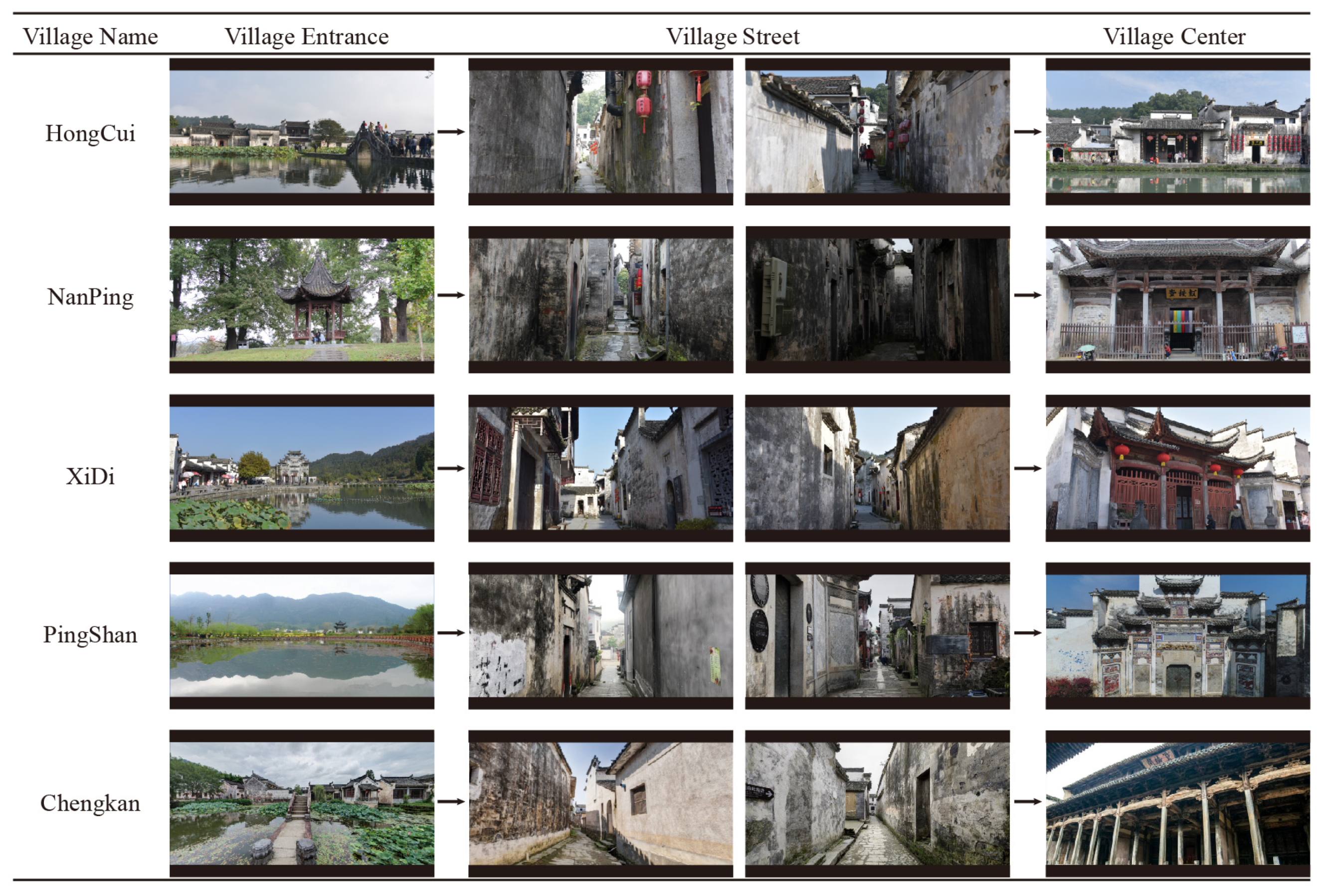
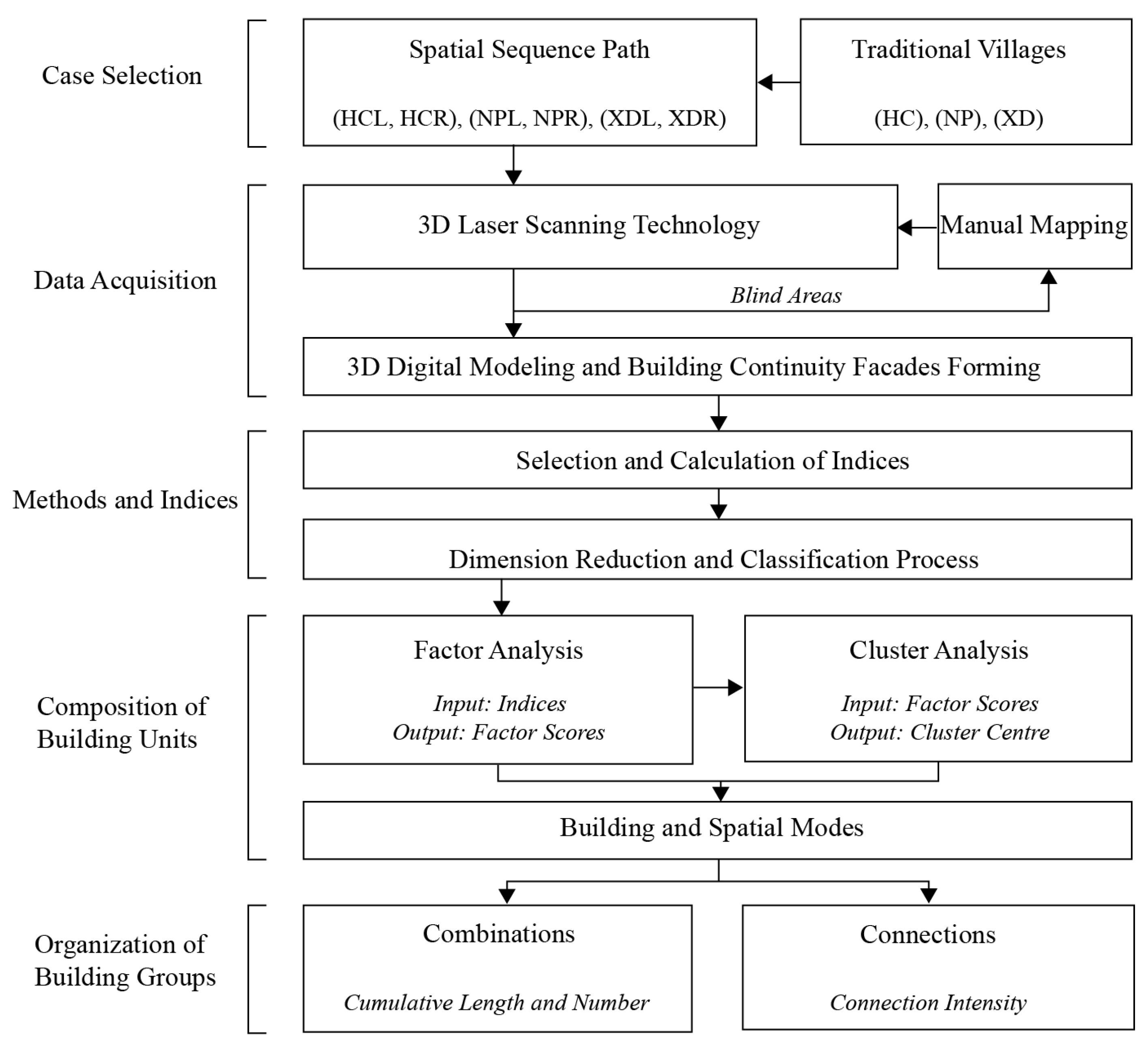
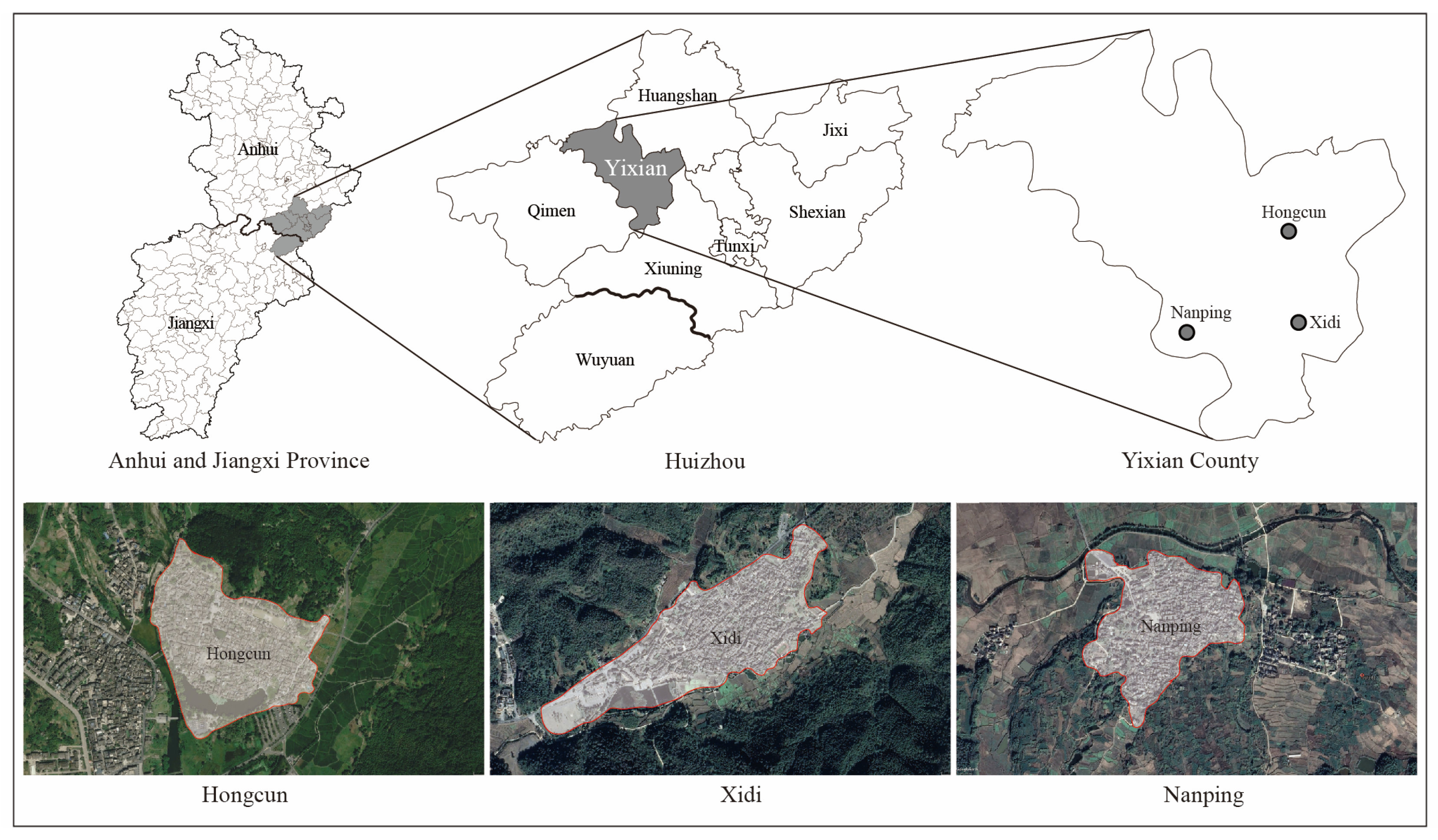
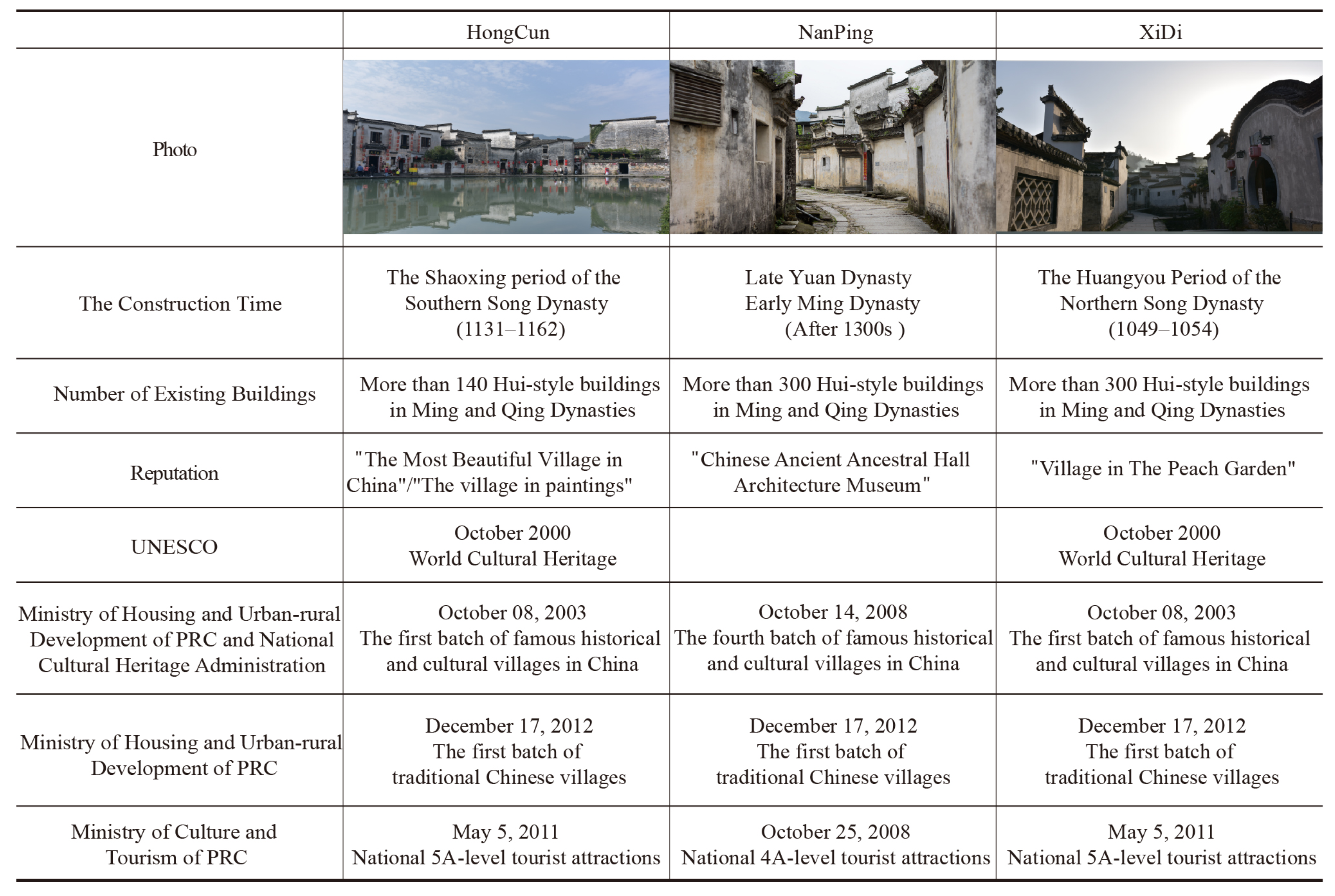
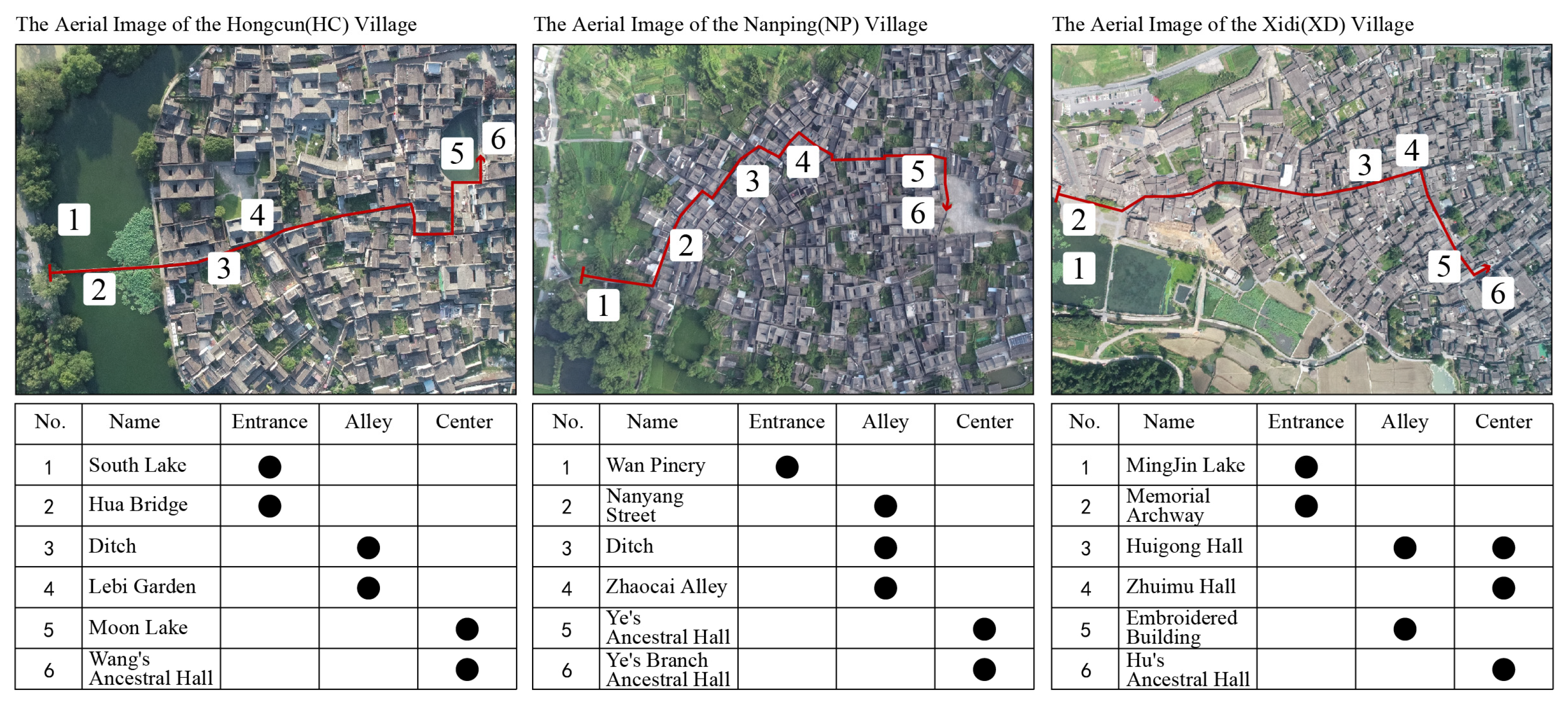
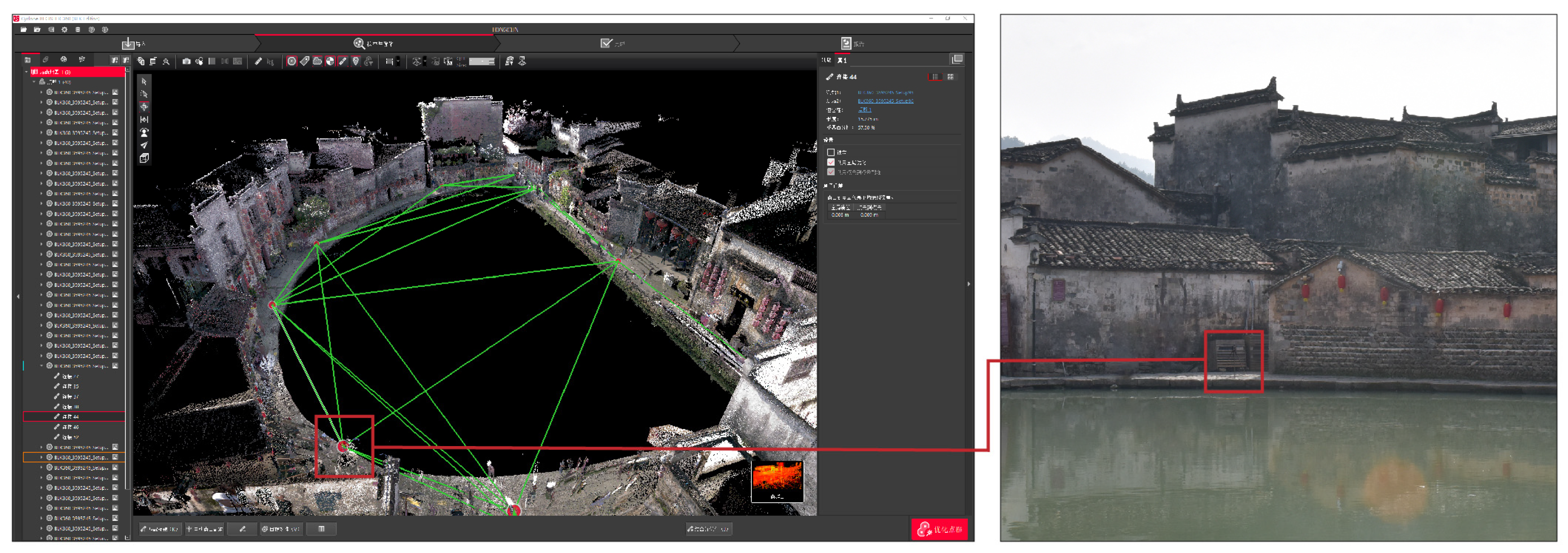
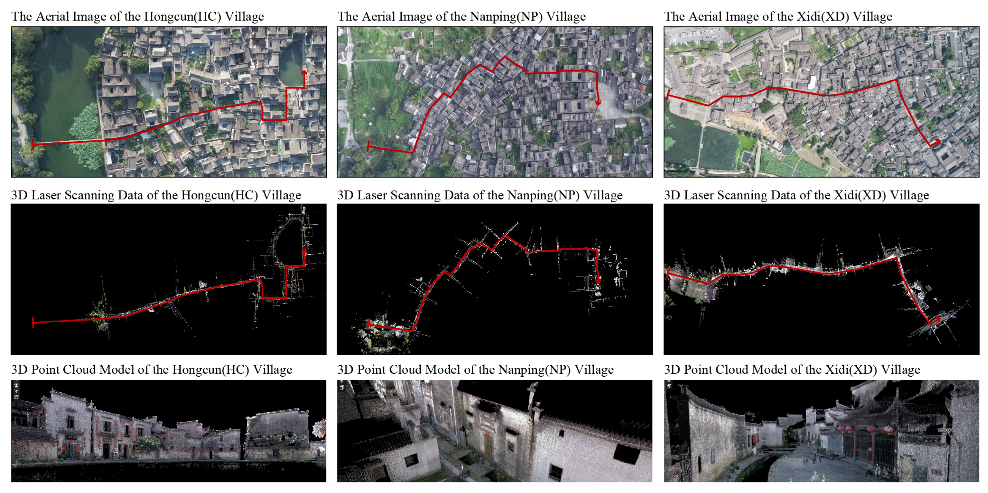
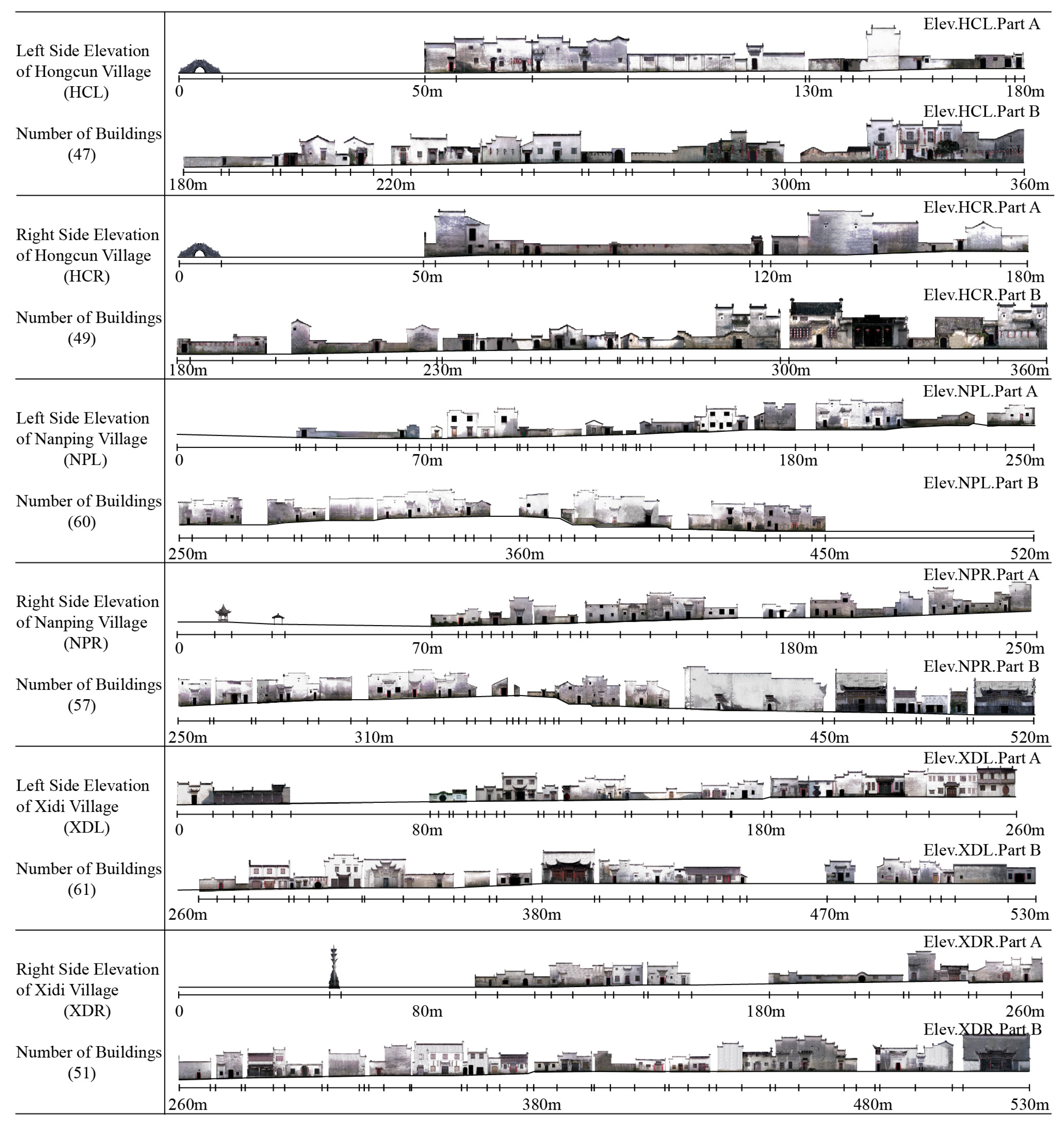
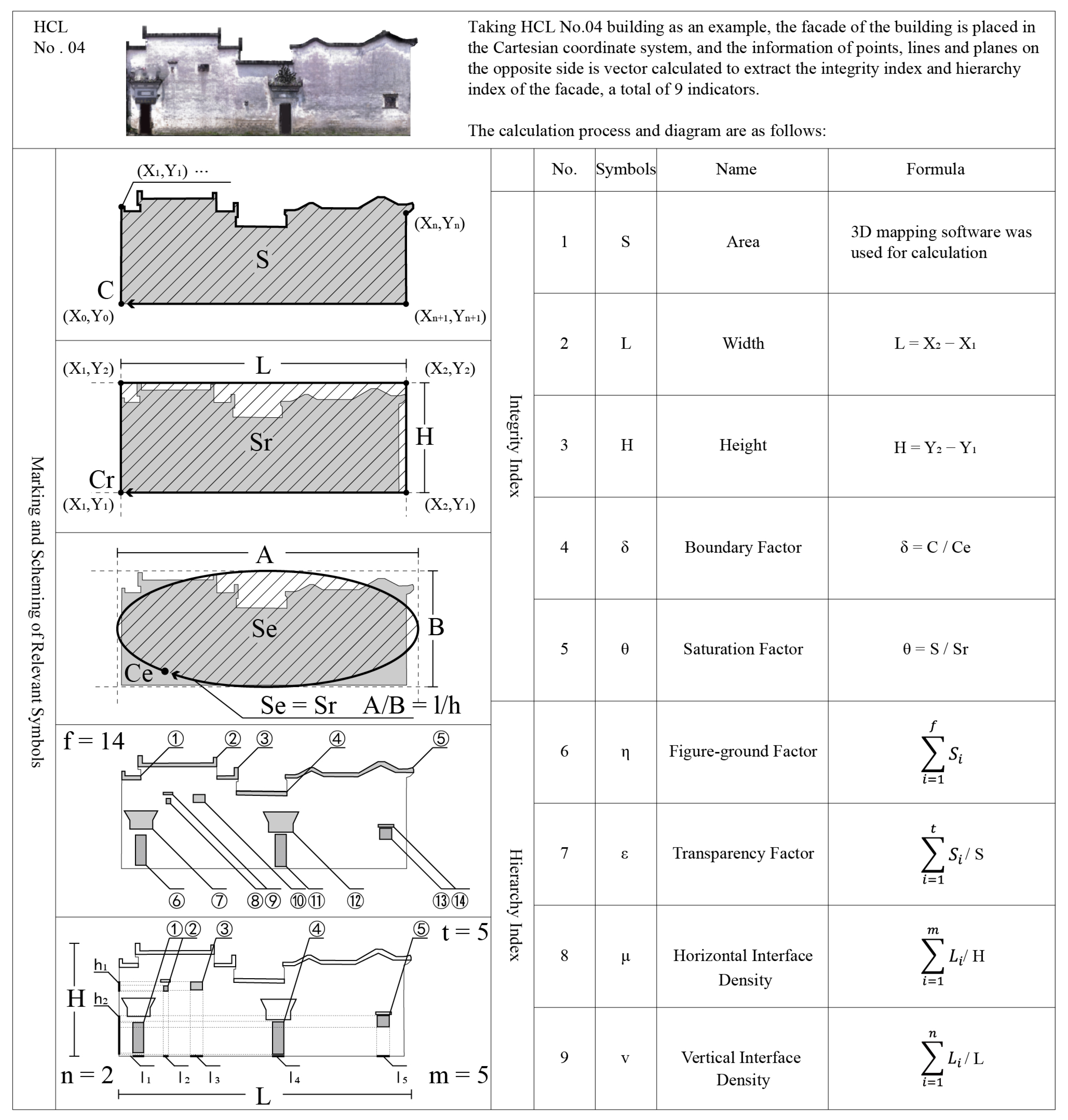
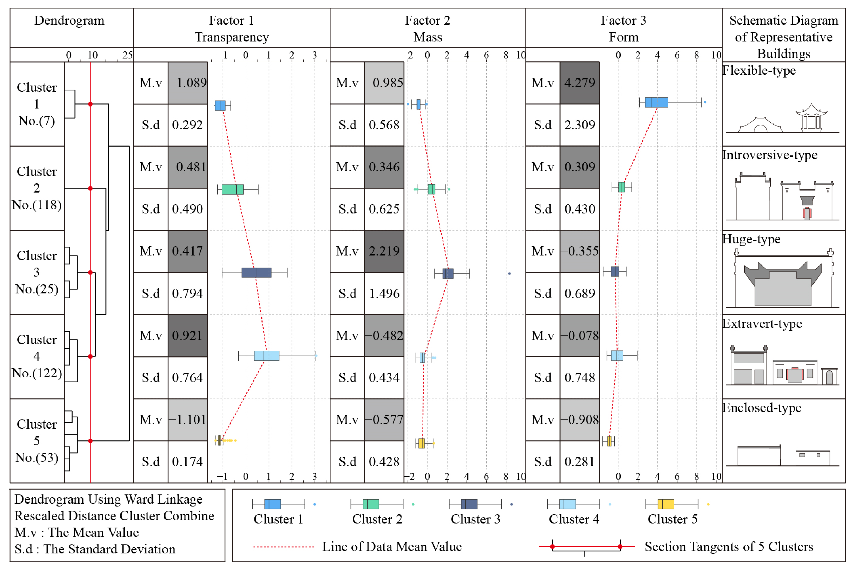
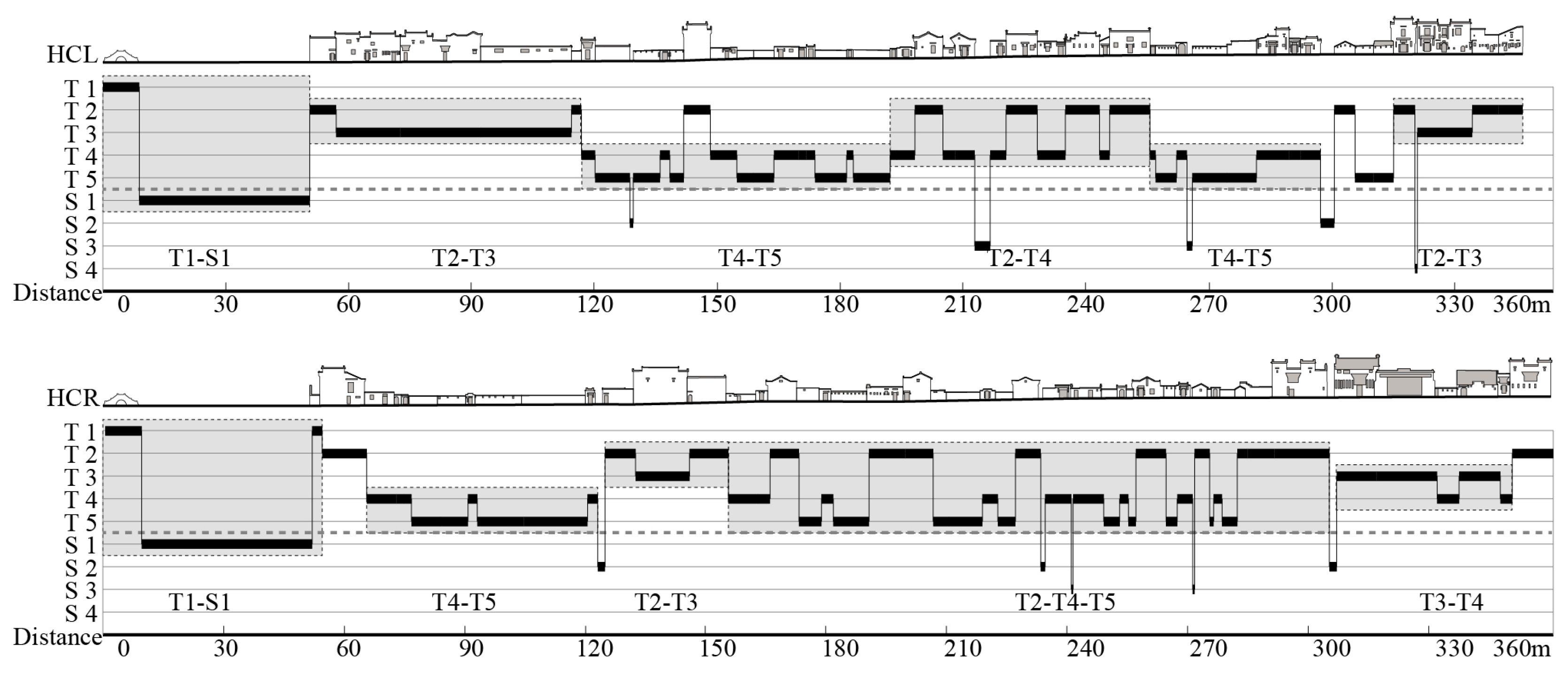
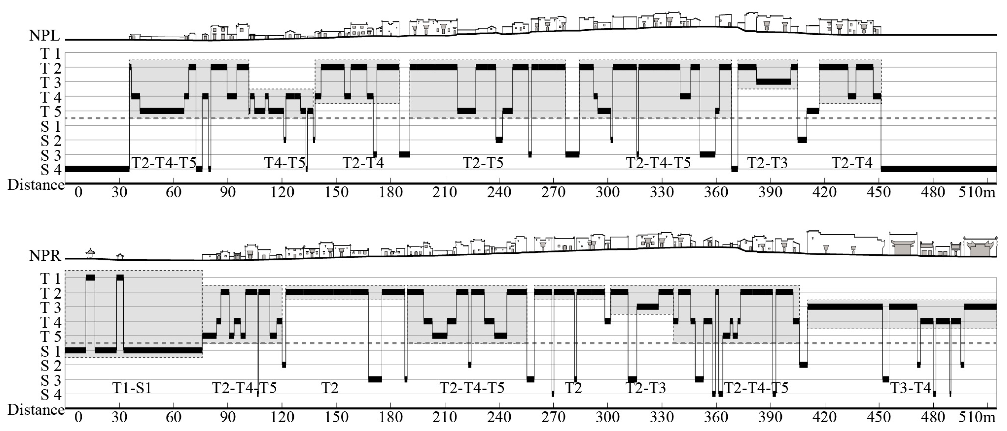
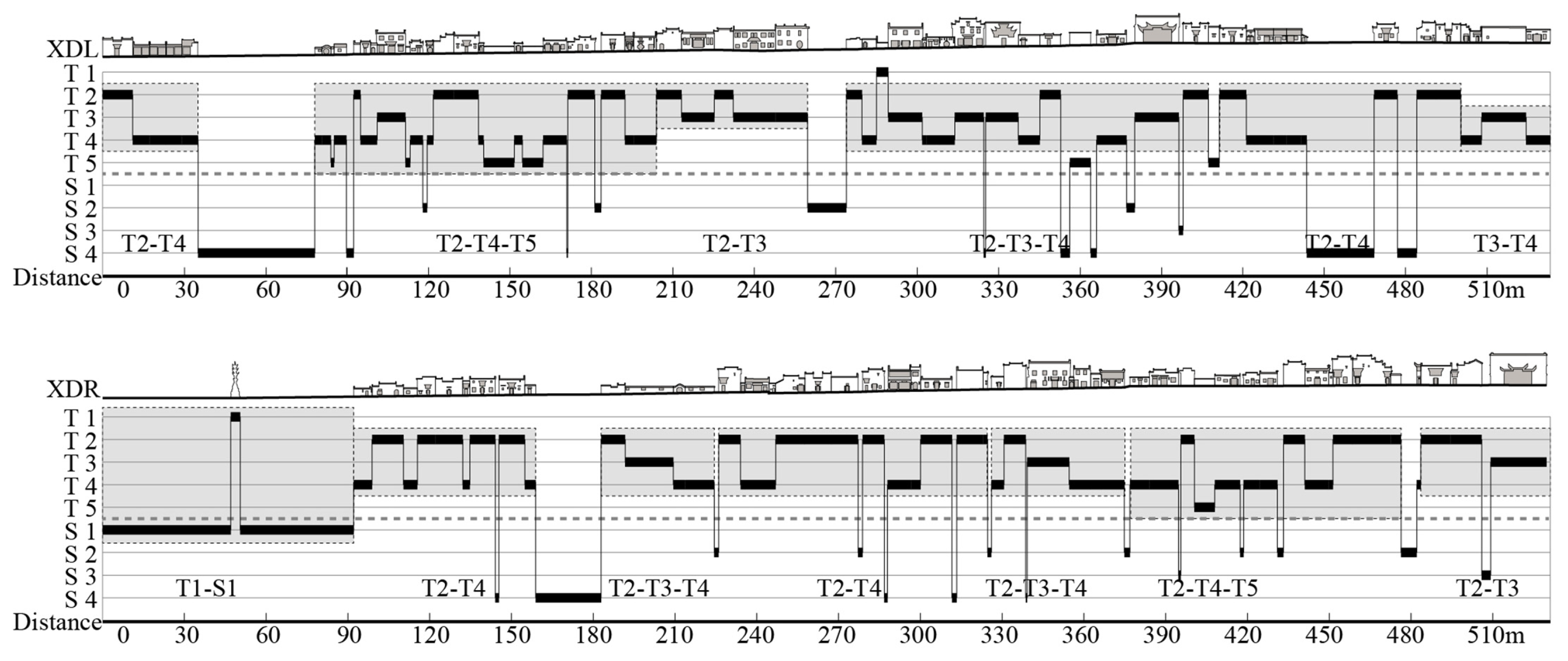
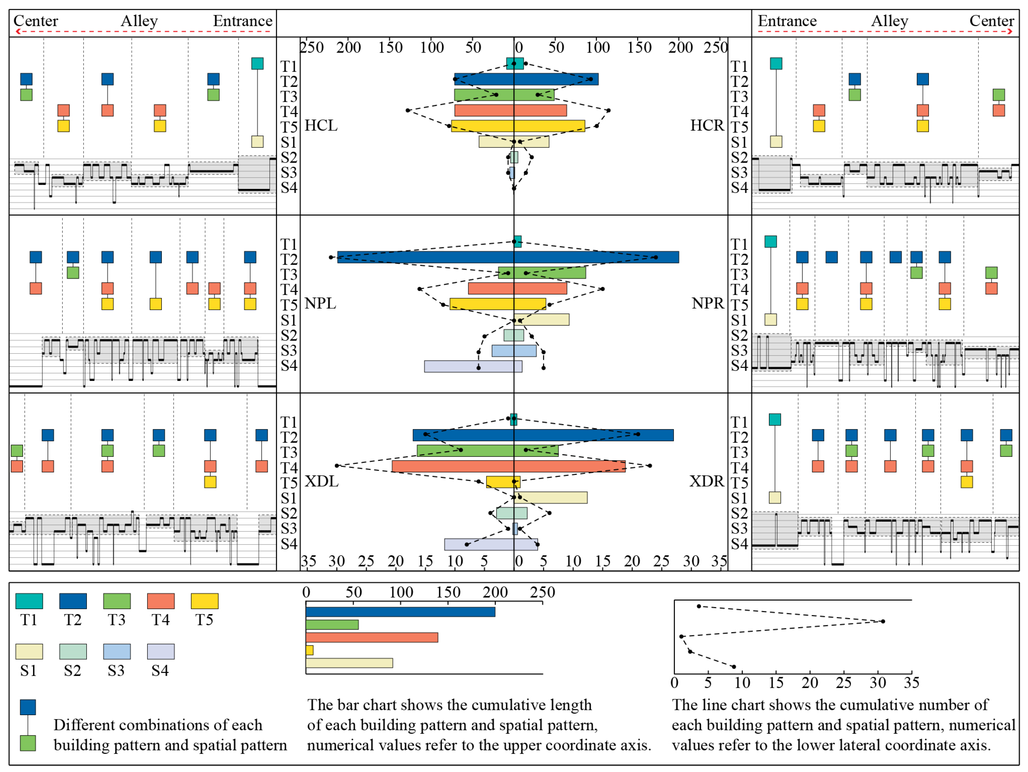
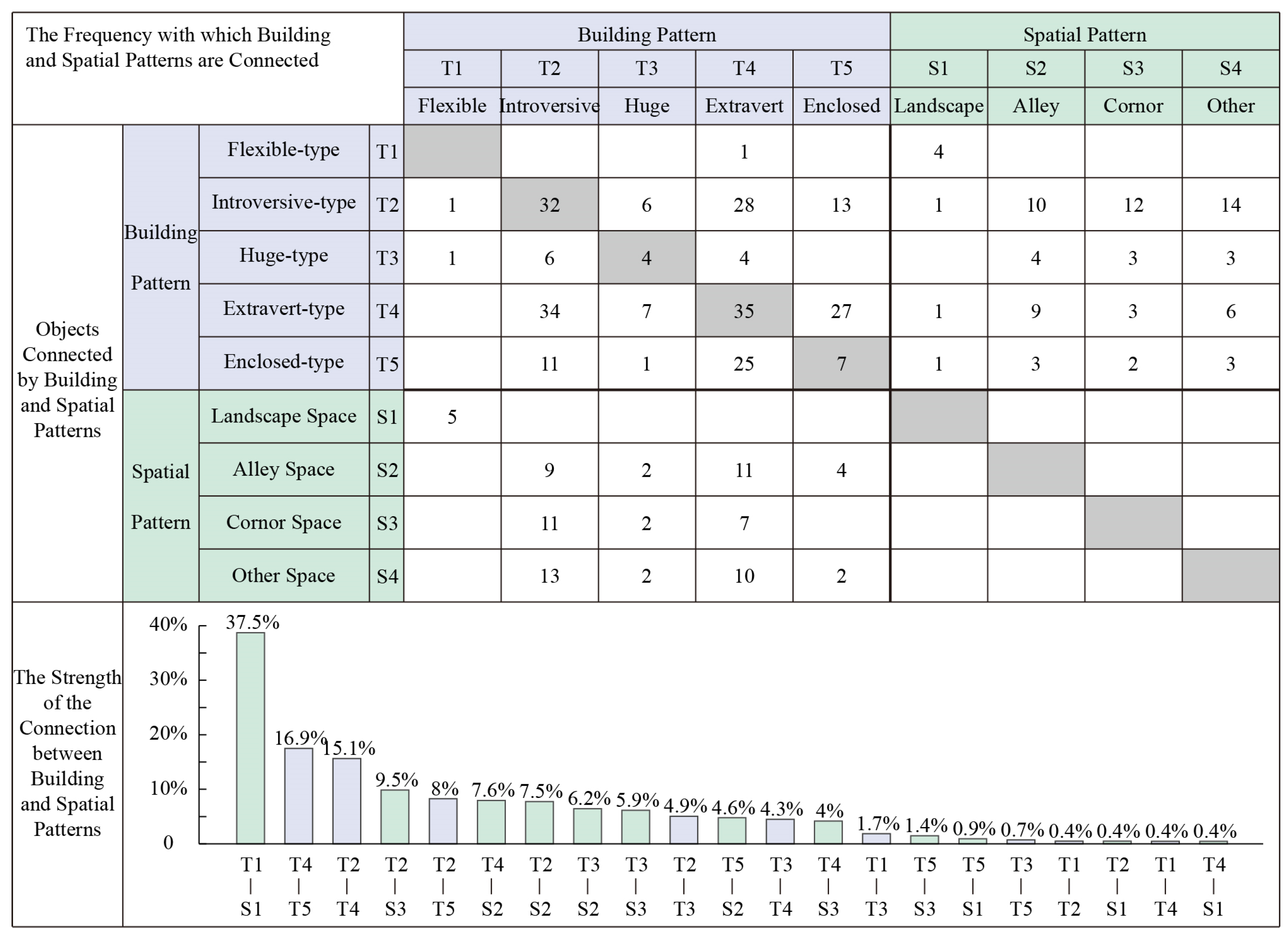
Table 1.
Point cloud data information in elevation processing.
| Name | Stations | Connections | Points | Error Range |
|---|---|---|---|---|
| N | N | N | (m) | |
| Hongcun | 40 | 62 | 330,955,640 | 0.005 |
| Nanping | 52 | 52 | 476,394,893 | 0.002 |
| Xidi | 53 | 59 | 460,721,560 | 0.003 |
Table 2.
KMO and Bartlett’s Test.
| Kaiser–Meyer–Olkin Measure of Sampling Adequacy | 0.651 | |
|---|---|---|
| Bartlett’s Test of Sphericity | Approx. Chi-Square | 2812.659 |
| df | 36 | |
| Sig. | 0.000 | |
Table 3.
Communalities.
| Variable | Index | Symbols | Initial | Extraction |
|---|---|---|---|---|
| X1 | Area | S | 1.000 | 0.958 |
| X2 | Width | L | 1.000 | 0.841 |
| X3 | Height | H | 1.000 | 0.748 |
| X4 | Boundary Factor | δ | 1.000 | 0.906 |
| X5 | Saturation Factor | θ | 1.000 | 0.877 |
| X6 | Figure–Ground Factor | η | 1.000 | 0.875 |
| X7 | Transparency Factor | ε | 1.000 | 0.937 |
| X8 | Horizontal Interface Density | μ | 1.000 | 0.907 |
| X9 | Vertical Interface Density | ν | 1.000 | 0.789 |
Table 4.
Total Variance Explained.
| Component | Initial Eigenvalues | Extraction Sums of Squared Loadings | Rotation Sums of Squared Loadings | ||||||
|---|---|---|---|---|---|---|---|---|---|
| Total | Variance | Cumulative | Total | Variance | Cumulative | Total | Variance | Cumulative | |
| % | % | % | % | % | % | ||||
| 1 | 3.506 | 38.953 | 38.953 | 3.506 | 38.953 | 38.953 | 3.487 | 38.745 | 38.745 |
| 2 | 2.730 | 30.339 | 69.292 | 2.730 | 30.339 | 69.292 | 2.445 | 27.168 | 65.912 |
| 3 | 1.602 | 17.802 | 87.094 | 1.602 | 17.802 | 87.094 | 1.906 | 21.182 | 87.094 |
| 4 | 0.443 | 4.917 | 92.011 | ||||||
| 5 | 0.280 | 3.113 | 95.125 | ||||||
| 6 | 0.200 | 2.220 | 97.345 | ||||||
| 7 | 0.118 | 1.315 | 98.660 | ||||||
| 8 | 0.076 | 0.841 | 99.500 | ||||||
| 9 | 0.045 | 0.500 | 100.000 | ||||||
Extraction Method: Principal Component Analysis.
Table 5.
Rotated Component Matrix a.
| Variable | Index | Symbols | Factor 1 | Factor 2 | Factor 3 |
|---|---|---|---|---|---|
| X7 | Transparency Factor | ε | 0.963 | −0.097 | −0.012 |
| X8 | Horizontal Interface Density | μ | 0.949 | 0.075 | 0.014 |
| X6 | Figure−Ground Factor | η | 0.925 | −0.107 | 0.091 |
| X9 | Vertical Interface Density | ν | 0.886 | 0.038 | −0.054 |
| X1 | Area | S | 0.001 | 0.978 | 0.039 |
| X2 | Width | L | −0.111 | 0.910 | −0.020 |
| X3 | Height | H | 0.055 | 0.781 | 0.369 |
| X4 | Boundary Factor | δ | 0.046 | 0.126 | 0.942 |
| X5 | Saturation Factor | θ | 0.032 | −0.085 | −0.932 |
Rotation Method: Varimax with Kaiser Normalization. a Rotation converged in 4 iterations.
Table 6.
Component Score Coefficient Matrix.
| Variable | Index | Symbols | Component | ||
|---|---|---|---|---|---|
| Factor 1 | Factor 2 | Factor 3 | |||
| X1 | Area | S | 0.019 | 0.419 | −0.089 |
| X2 | Width | L | −0.013 | 0.394 | −0.112 |
| X3 | Height | H | 0.025 | 0.297 | 0.115 |
| X4 | Boundary Factor | δ | 0.000 | −0.051 | 0.508 |
| X5 | Saturation Factor | θ | 0.023 | 0.069 | −0.508 |
| X6 | Figure–Ground Factor | η | 0.263 | −0.038 | 0.047 |
| X7 | Transparency Factor | ε | 0.276 | −0.022 | −0.011 |
| X8 | Horizontal Interface Density | μ | 0.275 | 0.050 | −0.016 |
| X9 | Vertical Interface Density | ν | 0.257 | 0.040 | −0.049 |
Component Scores.
Table 7.
Combination types of building and spatial modes in building group level.
| Combination Types Building Group Level | Village Name | Sum | ||
|---|---|---|---|---|
| HC | NP | XD | ||
| T2–T4–T5 | 1 | 5 | 2 | 8 |
| T2–T3 | 3 | 2 | 2 | 7 |
| T2–T4 | 1 | 2 | 4 | 7 |
| T1–S1 | 2 | 1 | 1 | 4 |
| T4–T5 | 3 | 1 | 0 | 4 |
| T3–T4 | 1 | 1 | 0 | 2 |
| T2–T3–S4 | 0 | 0 | 4 | 4 |
| T2 | 0 | 2 | 0 | 2 |
| T2–T5 | 0 | 1 | 0 | 1 |
Disclaimer/Publisher’s Note: The statements, opinions and data contained in all publications are solely those of the individual author(s) and contributor(s) and not of MDPI and/or the editor(s). MDPI and/or the editor(s) disclaim responsibility for any injury to people or property resulting from any ideas, methods, instructions or products referred to in the content. |
© 2023 by the authors. Licensee MDPI, Basel, Switzerland. This article is an open access article distributed under the terms and conditions of the Creative Commons Attribution (CC BY) license (https://creativecommons.org/licenses/by/4.0/).
Share and Cite
MDPI and ACS Style
Cheng, G.; Li, Z.; Xia, S.; Gao, M.; Ye, M.; Shi, T. Research on the Spatial Sequence of Building Facades in Huizhou Regional Traditional Villages. Buildings 2023, 13, 174. https://doi.org/10.3390/buildings13010174
AMA Style
Cheng G, Li Z, Xia S, Gao M, Ye M, Shi T. Research on the Spatial Sequence of Building Facades in Huizhou Regional Traditional Villages. Buildings. 2023; 13(1):174. https://doi.org/10.3390/buildings13010174
Chicago/Turabian StyleCheng, Geng, Zao Li, Shuting Xia, Mingfei Gao, Maosheng Ye, and Tingting Shi. 2023. "Research on the Spatial Sequence of Building Facades in Huizhou Regional Traditional Villages" Buildings 13, no. 1: 174. https://doi.org/10.3390/buildings13010174
Note that from the first issue of 2016, this journal uses article numbers instead of page numbers. See further details here.