Article

Impact of Land Use Diversity on Daytime Social Segregation Patterns in Santiago de Chile

1
Institute of Urban and Territorial Studies, Center for Sustainable Urban Development, (CEDEUS), Pontificia Universidad Católica de Chile, Santiago 8320000, Chile
2
Institute of Urban and Territorial Studies, Center for Sustainable Urban Development, (CEDEUS), Observatorio de Ciudades UC (OCUC), Pontificia Universidad Católica de Chile, Santiago 8320000, Chile
3
Center for Sustainable Urban Development, (CEDEUS), Observatorio de Ciudades UC (OCUC), Pontificia Universidad Católica de Chile, Santiago 8320000, Chile
*
Author to whom correspondence should be addressed.
Buildings 2022, 12(2), 149; https://doi.org/10.3390/buildings12020149
Submission received: 15 December 2021 / Revised: 17 January 2022 / Accepted: 24 January 2022 / Published: 31 January 2022
(This article belongs to the Topic Sustainable Built Environment)

Abstract

:
Latin American cities are known for their high levels of marginality, segregation and inequality. As such, these issues have been the subject of substantial discussions in academia, with the predominant approach being the study of residential segregation, or what we call “nighttime segregation”. Another dimension of urban sociability, related to labor, is what we call “daytime segregation”, which has been far less studied. This article makes an original methodological contribution to the measurement of non-residential or daytime segregation based on data from mobility surveys. It seeks to explain this segregation measurement according to the diversity and distribution of land uses, as well as other characteristics of the built stock, such as land price and built-up density. We measured daytime social mix in urban spaces, and we show how it highly relates to land use diversity in a Latin American megacity, such as Santiago, Chile. We found that land use diversity plays a key role in enhancing the daytime social diversity of urban spaces, contributing to generate a more heterogeneous city and social gatherings during working days. This research is not only a contribution to the understanding of sociability patterns in cities but is also a contribution to public policy and the work of urban planners, as it informs the development of more diverse and integrated cities, which is a key tool for strengthening democracy, the exchange of ideas, the economy and social welfare.

1. Introduction

Segregation, marginality and urban inequality are topics that have dominated theoretical discussions on urban issues in Latin America [1], especially after the first few years of the turn of the century. It was at this point when the spatial dimension of urban poverty began to be highlighted, focusing on spatial concentration, the reproduction of inequalities and the isolation effects on the most vulnerable social groups [2,3,4].
Residential segregation (RS) is the degree to which two or more social groups live separately from each other in an urban space [5]. Sabatini and company [3], defined it in opposite terms, as the degree of spatial proximity or territorial clustering of households belonging to the same social group, regardless of whether this is defined in terms of ethnicity, age, religious preferences or socioeconomic status. In the Anglo-Saxon world, the study of segregation has been mainly related to racial differences [6] and, in the case of Latin America, to income differences among inhabitants [7]. The debate has not only focused on the definition of the concept but also on the methodologies used to measure and represent it [8,9].
Practically all studies have focused on studying the social diversity/homogeneity of neighborhoods, considering residential spaces as one dimension of people’s sociability. In this paper, we defined this concept as “nighttime segregation”, when people are at home. Kaztman [10], warned that social segmentation in the case of Latin American cities does not only happen at a residential level but also that there are other dimensions of urban sociability in the labor market and essential services, i.e., dynamics and social gatherings that take place mainly during the day.
Reflecting on sociability in a more complex and comprehensive manner in large Latin American cities contributes to understanding the challenges of social cohesion in a democracy. Both notions of daytime and nighttime segregation refer to different conditions in which social groups interact with each other and relate to the social conditions that make democracy effective [11]. Therefore, this research is a contribution to both the theoretical understanding of sociability patterns in contemporary cities and public policy work, as it informs the development of more diverse and integrated cities as a tool to strengthen democracy, the exchange of ideas, the economy and social welfare [12,13,14].
Thus, this article aims to address the social diversity/homogeneity of a city from a new perspective by trying to characterize the phenomenon of urban segregation during the day, i.e., in workspaces and other daily activities that involve traveling outside residential spaces, understanding these spaces as a sociability sphere in the city different from the residential sphere. We analyzed how daytime segregation is geographically dimensioned by the social mix in urban spaces where people move around daily, using Santiago, Chile, as a case study. Furthermore, this study focuses on studying the roles that diversity of activities, land uses, built-up density and land prices play in enhancing socioeconomic diversity during the day, and how they contribute to generate a more heterogeneous city with spaces for social gatherings.
Few studies address this innovative dimension of segregation. Dannerman and others [15], proposed a methodological framework for investigating segregation during the workday. They used an approach that combines three mathematical tools, namely, community detection algorithms, segregation metrics and random walk analysis, with which they performed an analysis of Santiago, Chile, using mobile phone data, geographically dividing the city into macrozones. Its focus was to contribute to method development rather than to produce strong results. As such, the work presented in the present paper further complements and adds complexity to the findings made by these authors. In addition to studying the patterns of daytime segregation, this study analyzed them on a smaller scale than the one proposed by the authors, which allows for a greater differentiation of the phenomenon between neighborhoods. Our methodology also allows for the control of scale problems when measuring segregation, since the larger the unit area and the larger the population considered, the greater the homogeneity [2].
This paper is divided into four sections, excluding this one, which is for introductory purposes. The following section discusses the main studies on segregation and the dimensions analyzed, followed by an explanation of the methodology used. The subsequent section analyzes the results of the daytime segregation analysis, and the final section presents the main findings.

2. Residential Segregation, Daytime Segregation and Land Use Diversity

2.1. Nightime and Daytime Segregation in Latin American Cities

Latin American cities have a long history of being characterized by high levels of Residential segregation (RS) [3] and urban inequality [16]. There is consensus that urban residential segregation reduces the quality of life and opportunities for social mobility for the low-income population, because it weakens networks and their social capital and negatively affects the expansion of their cultural capital, restricting their possibility of accessing better jobs due to transportation costs. This gives rise to various forms of discrimination attributed to residential placement [3,17,18,19,20,21].
RS has been studied in its different dimensions and manifestations: (a) physical proximity between the residential spaces of different social groups [22]; (b) social homogeneity of the different territorial subdivisions into which a city is structured [23]; and (c) concentration of social groups in specific residential areas [3]. In this article, we understand residential segregation as “the geographic agglomeration of families of the same social status or category, however the latter is defined, socially, racially or otherwise” [23].
In the case of Latin American cities, there has been a wide discussion about the methods and techniques that have been used to measure segregation [8,9,24], where the debate has focused on the stratification method, the measurement of segregation and the problem of scale and its connection with social problems, among others [23], proposed three dimensions in the case of a Latin American city, two objective or measurable ones, that is, (a) the tendency of a group to concentrate in certain areas and (b) the formation of socially homogeneous areas, and a subjective one, that is, (c) people’s perception of the inhabitants of segregated neighborhoods [22].
Santiago is a city that has been widely studied in terms of urban segregation and growth [3,7,25,26,27,28,29,30]; urban processes, such as gentrification [31], spatial boundaries and community identities [32,33]; and residential trajectories of the inhabitants of a specific place in the city, focusing on central [34] or peri-urban spaces [35].
The different approaches agree that the social structure of the city of Santiago is marked by the presence of a “high-income cone”, which spatially concentrates social groups of higher socioeconomic status located at the northeastern geographic area of the city in the form of a cone [36], starting from the center and extending eastward. Moreover, studies on the recent evolution of spatial segregation show that the scale of segregation has been reduced, while the isolation of low-income groups, subjects of state social housing policies in Chile, has increased [3,7,28,29].
Other researchers have focused on the evolution of social structures in urban spaces, especially in the case of Santiago, as one of the cities most exposed to productive restructuring processes in Chile [3,7,25,26,28,29,37,38]. This research studied the spatial structure resulting from the restructuring processes of our economy, reaffirming the hypothesis of the moyennisation of the city, in accordance with international literature. However, this research was general and not focused on any specific class or other dimensions and their particularities. In the case of Santiago and others [26,39,40], studied residential mobility patterns but focused on centripetal residential movements [41] or on issues linked to gentrification processes [42], leaving out other urban growth trends [43].
These different approaches to the study of population distribution in space—or segregation—show an important bias, which is to consider the place of residence as the essential location of the population in the territory. This is a static vision of a city, which does not recognize the true urban condition [44]. As the scholar Mongin states, a city oscillates between an object city and a subject city. The same author states that the initial meaning of the urban condition is the possibility of diverse relations (corporal, scenic and political), as a place that shapes infinite practices and has a public connotation. For this reason, a static vision of segregation only from the point of view of the place of residence is not capable of embracing the complexity of a city from its most polymorphic condition.
Therefore, patterns of daily mobility in a city are important and should be considered as an important part of sociability, since they define what people could do and what they have done with their resources and opportunities at a given time and in a given context [45]. Considering the work of Shareck [46], we consider daily mobility patterns as structured by key locations, such as place of residence or location of work or school [47]. Mobility patterns have spatial and temporal dimensions and include factors such as the possibility of mobility, the spatial dispersion and form of travel, the degree of restriction, the flexibility and spontaneity of travel, the types of activities performed and the characteristics of the places where activities are carried out [46].
There is also a branch of studies that provide qualitative approaches to the measurement of problems related to daily mobility and socioeconomic origin in Latin America, focusing, for instance, on the experience, duration and modes of travel in Santiago [48,49]. For the city of Montevideo, Aguiar [50], used mixed methods to broadly characterize daily mobility, concluding that higher socioeconomic groups have, in general, greater mobility than lower groups, which, when added to gender and age factors, revealed that, in this Latin American city, the inequalities of origin limit the possibilities of daily mobility. Furthermore, Ureta [51], focused mainly on a group of residents of a low-income sector of Santiago to characterize their daily mobility, complementing this qualitative information with the city’s Mobility Survey database.
Furthermore, Dannerman and others [15], measured segregation during working hours using the Call Detail Record (CDR) database, where each mobile phone pings or the data connection is linked to cellphone towers. The spatial unit of measurement was Voronoi tessellations around each tower. In this study, the home location was assumed to be the most frequented tower at night and the work location as the tower with more pings during working hours. The main limitation of this study was the size of the geographic unit in which segregation was measured. This research applied a community detection algorithm, which divided the city of Santiago into six macrozones, larger than the municipal subdivision (the scale at which residential segregation in the city has been commonly studied). Measuring segregation in large geographic areas is more likely to show a higher level of overall integration than measuring it in smaller geographic units [2]. Another approach in the same line is that conducted by Li and others [52]. This work develops a methodology to measure urban segregation based on the socio-spatial daily experience of individuals in Hong Kong. Compared to traditional segregation measures, the proposed estimator is not limited to measuring residential segregation but recognizes and evaluates segregation as a dynamic process that unfolds in the daily life routines of individuals in a society and depends on the different ways in which individuals or social groups use urban space.
Therefore, some studies have associated the concept of daily mobility and activity space with the experience of social segregation, isolation or exclusion of individuals in urban space. Activity space, which encompasses the space that individuals visit and use when engaging in everyday activities [47], Golledge and Stimson captures the physical environment in which exposure and potential social interactions can take place [52]. Taking the above into consideration, we consider daytime segregation as “the level of geographic agglomeration of people of different social status at their place of visitation or work”.
Finally, given the breadth of the discussion and the approaches to residential and nighttime segregation, it is important to go beyond the literature, which has focused on the quantitative and qualitative aspects of the segregation of residential spaces but has not expanded on measuring segregation associated with other forms of daily sociability in workplaces, study and commercial activities. Although there have been approaches that seek to study the issues of daily mobility and socioeconomic stratification, these have mostly used qualitative methodologies, and although the quantitative approach proposed by Dannermann, presented an innovative community detection algorithm, methodological limitations arose in terms of the scale of the measurement of daytime segregation. By delving into the study of “daytime” segregation and its linkage with the characteristics of urban morphology, such as the diversity of land uses, built density and property values, this study aimed to better understand the position and relationships that different social groups have within a city. In addition, the first approach is proposed to understand which urban factors are decisive in promoting greater social diversity within the city during its day-to-day functioning.

2.2. The Role of Land Use Diversity

During the middle of the 20th century, urban planning based on ideas of modern movement dominated the main capitals of the world. Such an urban paradigm was based on the predominance of the automobile as a means of transportation and on land use planning, differentiating activities between home, leisure, commerce, and work [53,54]. The separation by land use was thought of to organize the urban fabric, thus providing a solution to the chaotic combination of uses, architectural styles and high-density street life of pre-modern cities [53,55]. However, the urbanist and social activist Jane Jacobs strongly criticized the modern urbanism paradigm in her book The Death and Life of the Great American Cities, arguing that problems associated with territorial dispersion, the dominance of the automobile, the destruction of pedestrian neighborhood life and the insecurity derived from the zoning of segregated uses would become a serious problem for daily life in a city. The avid discussion generated around these different views on urban planning developed into very different ways of thinking and experiencing a city and influenced future generations of planners.
Based on her own experience, contrary to the modern planning approach, Jacobs described how “cities work in real life, because this is the only way to learn what principles of planning and what practices in rebuilding can promote social and economic vitality in cities, and what practices and principles will deaden these attributes” [55] (4 p) The concept of urban vitality emerged to describe the bustling social and economic exchange that Jacobs observed on the streets of lower Manhattan in New York City during the 1960s. According to Jacobs, daily life in the streets is at the very core of what urbanity is and, to guarantee it, a certain set of requirements should be promoted. She proposed a set of four basic generators of diversity as conditions that would result in vibrant districts and neighborhoods [54] The first of the conditions proposed by Jacobs for an urban area to be vital is the diversity of land uses, or what she called mixed primary uses, which, according to Jacobs “must serve more than one primary function; preferably more than two” [55] (152 p). She proposed that a simultaneous combination of residences, offices and commerce, among other functions, is fundamental for urban vitality. The other conditions posited by Jacobs are an urban grid of small blocks—as opposed to the modern mega-block—which facilitates spontaneous meetings and crossings; a need for aged buildings interspersed with new construction in the urban grid; and a concentration of people, residences and buildings dense enough for spontaneous contact to occur [54,55,56].
Recent studies have approached Jacobs’ ideas and her definition of urban vitality using empirical methods with a special focus on land use diversity as one of the key factors. The research by Delclòs-Alió and Miralles-Guasch, focused on empirically obtaining the variables proposed by Jacobs for urban vitality and posing a synthetic urban vitality index for the city of Barcelona. Furthermore, the research done by Xia, and others, on five megacities in China studied the relationship between urban vitality—measured by small business transaction data and nighttime lighting—and contemporary compact city characteristics, such as mixed land use and high density, finding a significant positive spatial autocorrelation between urban land use intensity and urban vitality [32]. Moreover, the study by Li, and others, for the city of Shangzhen in China focused on measuring the relationship between morphology and urban vitality [52]. They found that a dense street grid, small to medium-sized blocks and the diversity and intensity of construction and land use are beneficial to urban vitality. These morphological metrics encourage and extend urban vitality and serve to promote urban sustainability and fight inefficient and disorderly urban sprawl [52].
Another specific precedent for the measurement of a land use diversity indicator was presented by Frank and others, who proposed the use of the entropy indicator to measure land use diversity, with the purpose of introducing it as one of the variables for an urban walkability index [57]. The authors considered five types of land use to measure diversity: residential, commercial, leisure (including restaurants), offices and institutions (including schools and community organizations). Subsequently, the previously mentioned study [54], adapted this indicator and used it as a variable to estimate the urban vitality index following Jane Jacobs’ approaches, adding a category for other land uses and calculating the land use diversity based on the Shannon Index, used mainly in ecology to measure species diversity. Finally, other authors studied urban vitality in Santiago and concluded that this type of measurement broke the traditional scheme of analysis of the capital city of Chile and showed other patterns of urban space organization [32].
This study measured land use diversity, built-up density and land values to explain the phenomenon of segregation and social integration during daytime, assuming that a greater diversity of socioeconomic groups during the day is an indicator related to urban vitality, understanding it from the perspective of diversity and social exchange as proposed by Jacobs.

3. Materials and Methods

The present study employed a quantitative method focused on data analysis of various sources to study daytime segregation patterns—measured using socioeconomic and mobility data from the latest Origin-Destination Survey (EOD, as per its Spanish acronym) in Santiago—and their possible association with urban characteristics. These characteristics include the diversity and proportion of land uses—measured using the database of the Internal Revenue Service (SII, as per its Spanish acronym)—while also incorporating other control variables, such as building density and land values, obtained from the SII database and the Real Estate Registrar (CBR, as per its Spanish acronym) database, respectively. We measured associations from linear regression models and spatial clustering models to analyze agglomeration patterns, inherent to this type of phenomena [58,59]. The geographic unit of analysis corresponds to the EOD survey zoning (EOD zone), to which information from the 2017 Census is cross-tabulated, as well as other territorial variables to enrich the available explanatory variables.
We chose this methodological approach with the aim to replicate the classic residential (nighttime) segregation measurements, in this case with the entropy indicator, using the latest available daily mobility data. At the same time, we decided to measure the association with land use diversity and other built environment characteristics, given the important relationship of such indicators in the urban vitality literature (see Section 2.2).

3.1. Definitions

Based on the literature review and available datasets, we define the key concepts for our methodology as follows:
  • Mobility: transportation across the city from an origin point to a destination point, with a purpose and a commuting mode.
  • Daily mobility: commuting across the city daily.
  • Nighttime segregation: a measurement of different social groups’ geographical separation or lack of mixture in a determined geographical unit. This is measured using residential socio-economic characteristics and is also known as residential segregation.
  • Daytime segregation: a measurement of different social groups’ geographical separation or lack of mixture in a determined geographical unit, measured during daytime hours, with socioeconomic data linked to mobility information.
  • Social diversity: the exact opposite to social segregation, meaning a measure of the degree of social mixture between different groups in a determined geographical unit. The entropy indicator is the measurement used in this paper.
  • Land use diversity: a measurement of the mixture of land uses present in a determined geographical unit.

3.2. Measuring Daytime Segregation

Using the EOD mobility survey database for the city of Santiago, we estimated the socioeconomic daytime segregation during working hours for those areas declared as travel destinations. The socioeconomic classification of respondents was based on their survey answers concerning household income and housing expenditure.
First, the household base of the EOD mobility survey was classified into three socioeconomic groups (High, Middle and Low groups). For this, we worked with the EOD database at the household level and divided it into terciles according to total household income. Subsequently, the following adjustment was applied to control for housing affordability and actual disposable income: all households in the High group that spent more than 30% of their income on housing were moved to the Middle group, while all households in the Middle group that spent more than 50% on housing were moved to the Low group. Subsequently, this information was transferred to the respondent database and to the EOD survey trip database. Finally, the trips were grouped by destination zone using the normal working day expansion factor, considering a minimum of 5 trips per destination zone and excluding those zones with fewer trips. Using the expansion factor, the number of people considered totaled 91,313.
For the calculation of daytime segregation, entropy was estimated using Geo Segregation Analyzer software. This indicator accounts for the possibility of encountering someone from another group for each destination EOD zone that received more than 10 people in a normal working day. In order to evaluate daytime segregation, the original value is inverted and scaled, remaining between 0 and 1. Thus, 1 was perfect segregation (presence of only one group), and 0 was perfect integration (perfect balance between all groups).

3.3. Measuring Land Use Diversity

From the SII cadastral base, urban land uses were divided into seven types: (1) commerce, (2) facilities (including recreation, accommodation, worship and parking lot facilities), (3) education and culture (these are considered of single use in the SII base), (4) residential, (5) industrial (including warehouses), (6) offices (including public administration) and (7) health. Using the ArcMap’s Spatial Join tool, the information concerning surface area by land use contained in the SII blocks belonging to the consolidated urban area of Santiago was transferred to the EOD zones to standardize the geographic unit of analysis. Adapting the methodology of Delclòs-Alió and Miralles-Guasch, the land use diversity indicator was calculated as the sum of the proportion of each land use multiplied by the natural logarithm of that proportion by use. The value obtained was then scaled between 0 and 1, so that 1 was perfect land use diversity and 0 was land use diversity, or only one type of land use.
Given that the EOD zones are not homogeneous in terms of surface area, they tend to be larger in size in the urban periphery, and at the same time, the indicators of segregation (entropy) and land use diversity (Shannon index) measure the possibility of finding another group within a given area. In EOD zones with a larger surface area, the diversity or integration in both indicators tends to increase since they consider a greater surface area. This is a limitation in this study due to the geographic scale of the available mobility data (EOD).

3.4. Statistical Analysis

Our analysis aimed to establish a statistical explanation for the apparent relationship between daytime segregation and land use, which, together with other variables related to urban morphology, such as built-up density and land value, could explain why citizens of different socioeconomic groups travel to certain areas, influencing daytime segregation.
This study used the daytime segregation calculation as the dependent variable, and we evaluated the following linear regression models:
Model 1: The first model is a univariate linear regression using the land use diversity index as the independent variable and the segregation index as the dependent variable, as indicated by the following formula:
Daytime segregation = ß0 + ß1 × Land Use Diversity
Model 2: The second multivariate model evaluates the relationship between the built-up area (measured in 1000 m2) for each use and the segregation index, according to the following formula:
Day Segregation = ß0 + ß1 × Land Use Diversity + ß2 × Commercial Area + ß3 × Facilities Area + ß4 × Education and Culture Area + ß5 × Residential Area + ß6 × Industrial Area + ß7 × Office Area + ß8 × Health Area
Model 3: In this model, the land price expressed in development units (UF, as per its Spanish acronym) per square meter of land is added as a control variable.
Daytime Segregation = ß0 + ß1 × Land Use Diversity + ß2 × Commercial Area + ß3 × Facilities Area + ß4 × Education and Culture Area + ß5 × Residential Area + ß6 × Industrial Area + ß7 × Office Area + ß8 × Health Area + ß9 × Land Price
Model 4: In addition to the variables already evaluated in the previous models, built-up density is added as a control variable, measured in 1000 m2 per hectare of land.
Daytime Segregation = ß0 + ß1 × Land Use Diversity + ß2 × Commercial Area + ß3 × Facilities Area + ß4 × Education and Culture Area + ß5 × Residential Area + ß6 × Industrial Area + ß7 × Office Area + ß8 × Health Area + ß9 × Land Price + ß10 × Built-up Density.
Model 5: The same variables as those in Model 4 are used, but a filter of a minimum of 50 trips per EOD zone is applied.
Daytime Segregation = ß0 + ß1 × Land Use Diversity + ß2 × Commercial Area + ß3 × Facilities Area + ß4 × Education and Culture Area + ß5 × Residential Area + ß6 × Industrial Area + ß7 × Office Area + ß8 × Health Area + ß9 × Land Price + ß10 × Built-up Density.

3.5. Spatial Statistical Analysis

The phenomenon of daytime segregation, derived from the floating population, is theoretically related to the spatial agglomeration patterns of daily trip destinations. Despite this, a quantitative review of the data and their spatialization (Figures 1–3) revealed two phenomena: a certain territorial dispersion and, at the same time, a concentration of integrated daytime zones in Santiago’s central business district (CBD). In order to understand these concentration patterns, test their statistical significance and support the explanation derived from the linear statistical model, a spatial statistical analysis was performed.
The first analysis performed was the application of Moran’s I, which comprehensively measures the variation of spatial autocorrelation between close neighboring values, indicating whether it exists or not and what the sense of the mentioned phenomenon of the spatial autocorrelation is.
Subsequently, the local downscaling of Moran’s I, the local indicator of spatial association (LISA), was applied, specifically the Anselin Local Moran’s I, for the analysis of clusters and outliers. This descriptive analysis indicates whether local association (clusters) exists and where it is located, specifying statistically significant groupings between neighbors, with high–high, low–low, low–high and high–low values.

4. Results

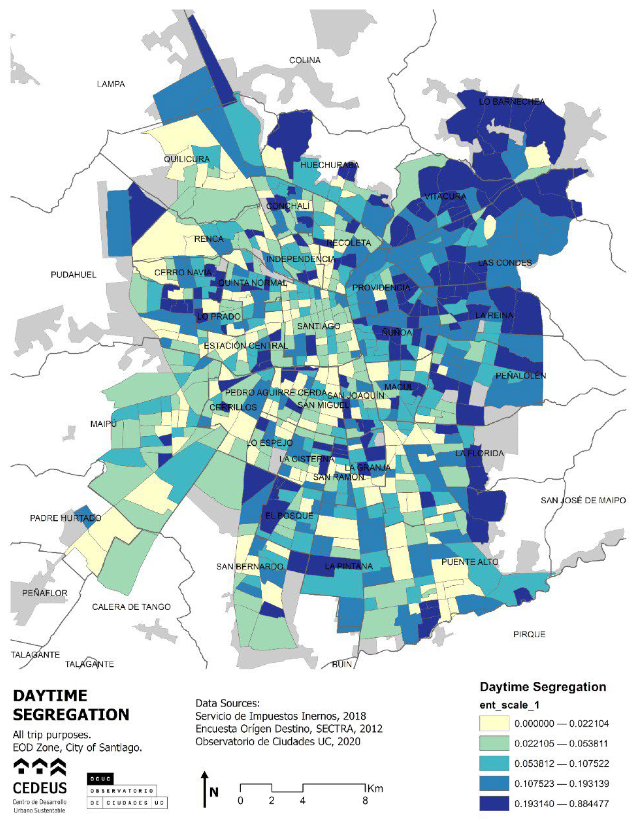
4.1. Spatial Distribution of Daytime Segregation

In general terms, the daytime segregation index (Figure 1) showed downtown Santiago and some pericentral sectors with high daytime integration; these integrated sectors also extend to peripheral industrial sectors, such as Quilicura, Renca, Cerrillos, San Bernardo and Calera de Tango. The greatest daytime segregation was concentrated in the northeastern cone, in Vitacura, Las Condes, La Reina, Ñuñoa and parts of Providencia (sectors that, in general, are the ones with the highest segregation of high income in the Santiago Metropolitan Area). In addition, we observed a clustering of segregated areas in the foothills of Peñalolén, La Florida and Puente Alto. However, there were also scattered areas of high segregation, without a clear pattern of concentration, in pericentral areas.
The distribution of the land use diversity indicator (Figure 2) showed a center–periphery pattern, where the center and immediate pericenter of the municipality of Santiago concentrate a high diversity of land uses, extending toward the northeastern cone and toward major transportation axes, such as Vicuña Mackenna Avenue, Gran Avenida and Providencia Avenue. As expected, in general terms, we observed a low land use diversity in the periphery, except for sectors with industrial centers and university campuses. We finally reviewed the cartographies of all variables’ distributions in the city (Figure 3).

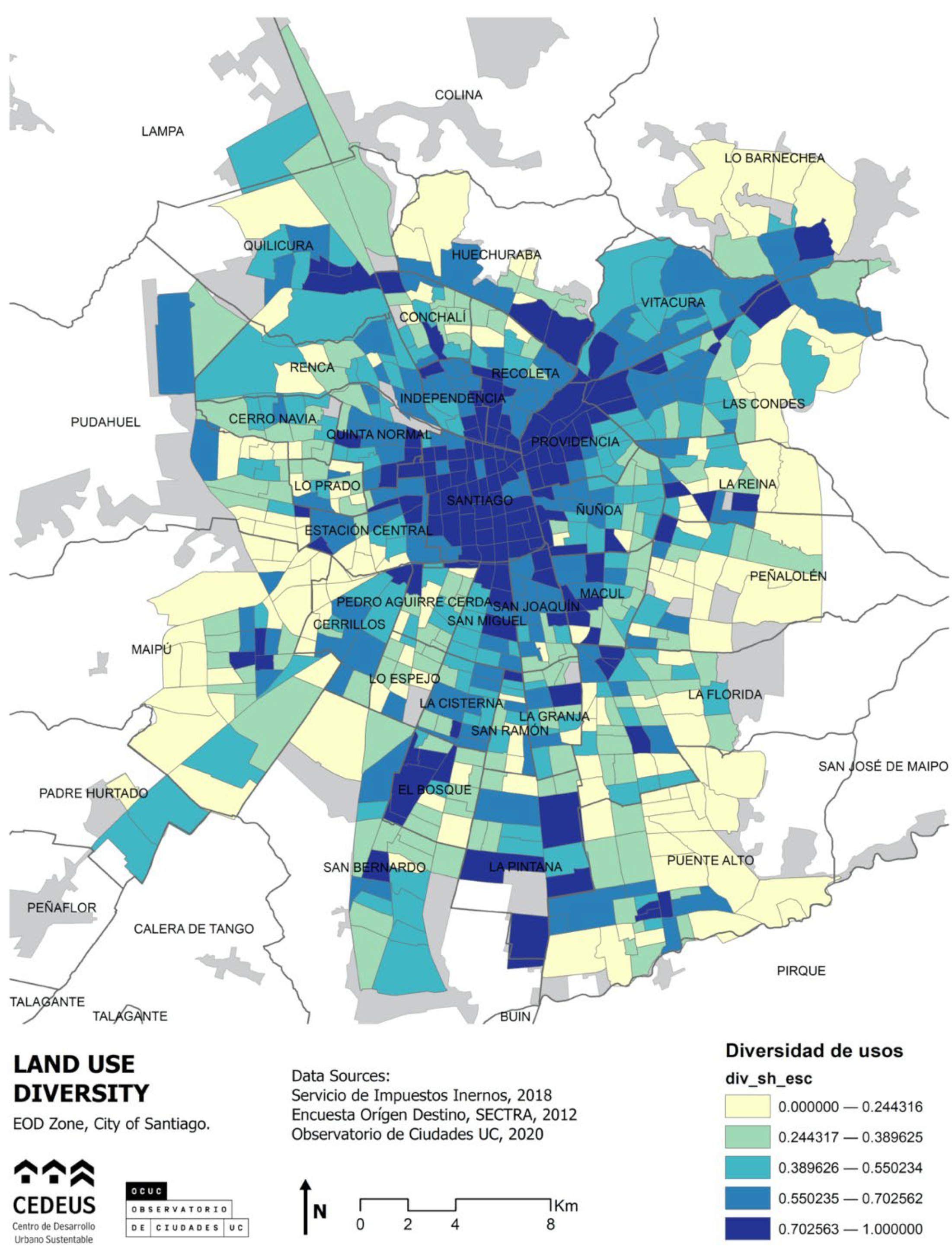
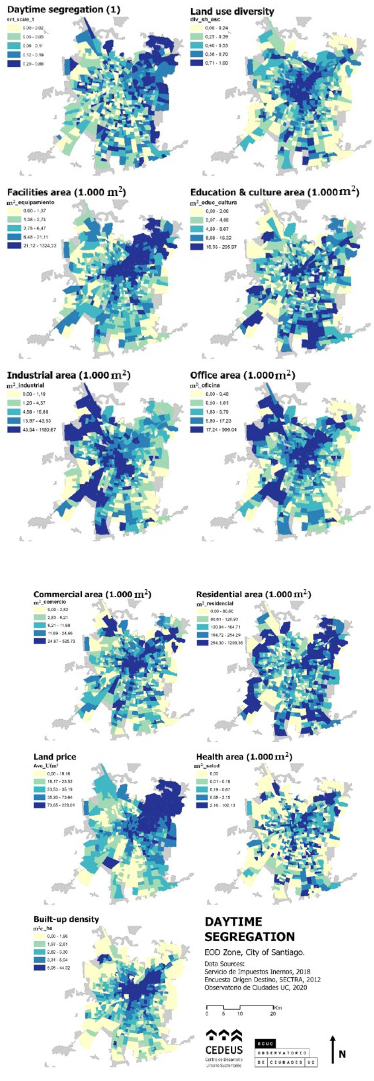
4.2. What Is the Relevance of the Diversity of Activities?

Based on the statistical analysis (Table 1), we found that land use diversity significantly reduced daytime segregation in the five models evaluated. Likewise, commercial, education and culture, residential and industrial uses alone reduced daytime segregation, even when controlling for the surface area of the different uses, land price and built-up density. Moreover, the area of the facilities used increased daytime segregation, but it was not statistically significant in Model 3 when controlling for land price (UF/m2), the latter variable being significant and increasing daytime segregation. As for R2, there was an important change when adding UF/m2, explaining 0.15.
Model 4 showed that when adding built-up density, this variable was significant, as it decreased segregation, while the rest of the variables did not show major changes, except for a drop in the land use diversity coefficient. Model 5 used the same variables as those in Model 4 but with a minimum number of 50 trips; education/culture, residential and industrial uses were no longer significant, but the meaning and significance of land use diversity, commerce, land price and built-up density were maintained. In this model, the R2 was 0.20 when the n-trips filter with 552 observations was applied.

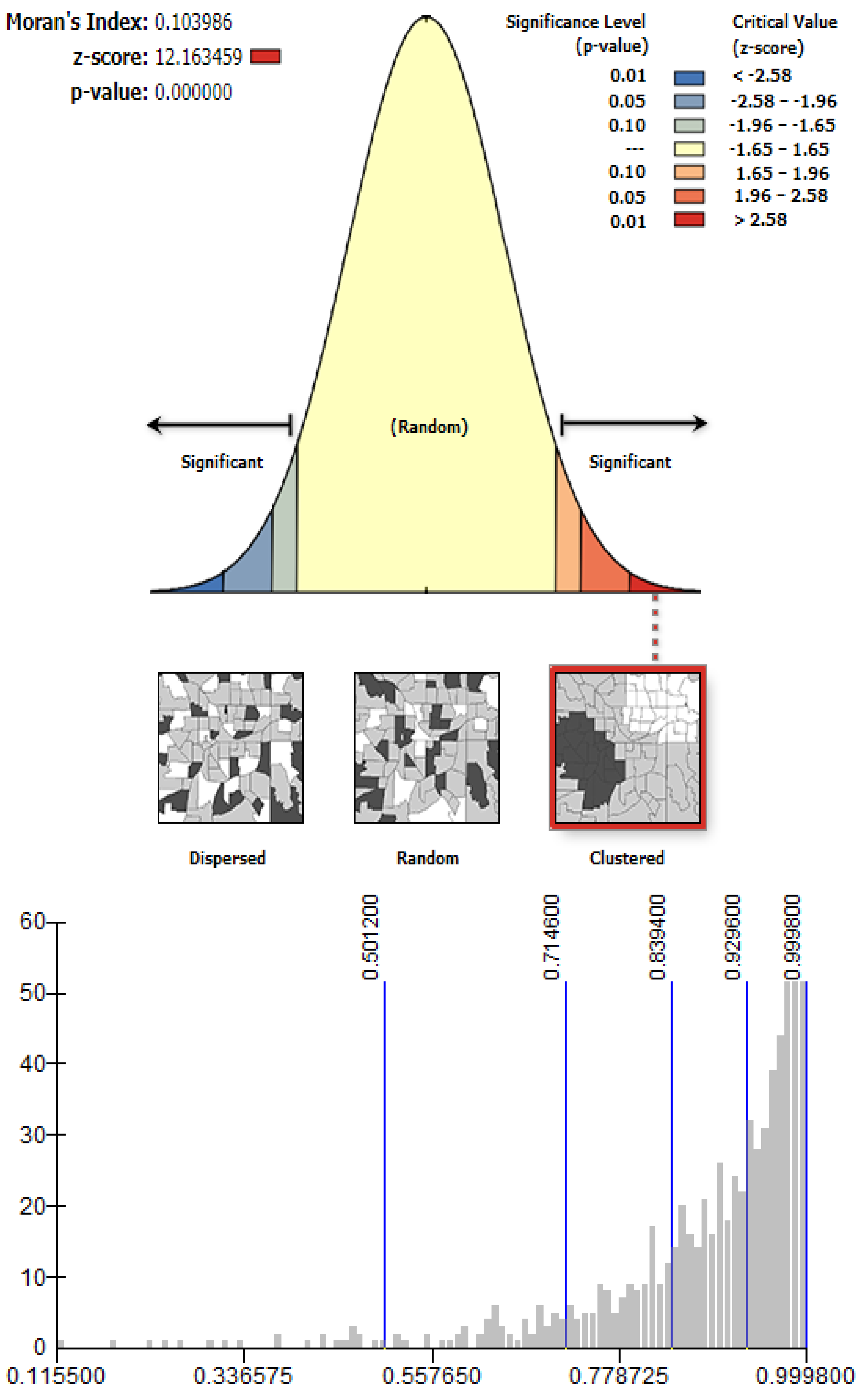
4.3. Spatial Statistics

The first result of the Moran’s index revealed the spatial clustering of the daytime segregation phenomenon, which means that beyond that observed in Figure 1, the phenomenon was indeed concentrated, not at the same level as the other variables, such as income and daytime segregation, but enough to appear clustered with a significance level of 99%. However, the low Moran’s index (0.1) and the relatively high Z-Score (12.2) showed a non-normal distribution, with a bias toward integrated values and much lower segregated values, which were nevertheless concentrated (Figure 4).
To analyze such inference in greater detail, we applied the local downscaling of Moran’s index, the local indicator of spatial association (LISA), specifically the Anselin Local Moran’s I index (analysis of clusters and outliers). This analysis was applied to the variable daytime entropy, that is, to the variable that measures social integration (inverse to segregation). Therefore, the high–high values refer to clusters of integrated daytime residents with significant spatial autocorrelation. This was the case for downtown Santiago and other areas such as Quilicura, the center of Maipú and the center of Puente Alto. It is also worth mentioning that the presence of a large low–low cluster, that is, an area segregated during the day, in the eastern cone of the city of Santiago, corresponding to the municipalities of Providencia, Las Condes and Vitacura (Figure 5). This northeastern part of Santiago is an area with high land values and high-class residents, being one of the most nighttime-segregated areas of the city, a phenomenon formally called self-segregation [3].

5. Discussion

This article makes a methodological contribution to the measurement of non-residential or daytime segregation based on data from mobility surveys. It seeks to explain this segregation measurement according to the diversity and distribution of land uses, as well as other characteristics of the built stock, such as land price and built-up density.
Our findings indicate that, in the case of the city of Santiago, daytime segregation is significantly reduced by the diversity of land uses, when analyzing the destination of daily trips. Likewise, urban characteristics (such as built-up density and built-up areas for commercial use) reduce segregation, while land price increases it. Our research yielded convincing results: the diversity of land use explains between 9% and 13% of the social diversity in the studied area during the day. This indicates that the places in the city where it is possible to find a greater diversity of land uses are the ones that attract the greatest diversity of people from different socio-economic backgrounds during the day.
As for the spatial clustering of the daytime segregation phenomenon, we found a concentration of integrated zones in the historic center of the city (municipality of Santiago and surrounding areas). Moreover, we found clustering in urban sub-centers, such as the area around bus stop 14 in La Florida, the center of the municipality of Maipú and the industrial zone of Quilicura. In addition, the eastern cone sector of Santiago showed a concentration of daytime segregation, being an area that is traditionally segregated at night (RS), which also concentrates the highest land value in the city (Figure 4). This is consistent with the results of the linear models, which indicate that daytime segregation significantly increases with increasing land value. Furthermore, the spatial statistics’ analysis shows that, during daytime, it attracts daily commuters but remains a highly segregated area (a low–low entropy or social mixture cluster in Figure 5). Considering that it is an area with general land use diversity low in its periphery, but high in its most centric areas, as well as dominated by office and residential land uses (Figure 3), we conclude that this is an area that mainly attracts high-class residents of different areas within the northeastern cone.
Although measured on a different geographic scale, the findings of Dannerman et al. (2018) for Santiago de Chile are similar to ours regarding the high-rent eastern cone of Santiago, a highly segregated area that attracts residents from within the area. Furthermore, our results for central Santiago converge with such research by the finding of a low daytime segregation area. However, the same study found high segregation (concentrating low-rent commuters) in the southeastern area of Santiago as opposed to our spatial analysis results, which found a non-significant concentration in most of its area and a significant low segregation zone in its center (frontier of La Florida and Puente Alto municipalities, Figure 5). Our contribution beyond such research is to relate these findings with land use diversity and to find a significant correlation with daytime segregation patterns.
Compared to the Hong Kong study [52], our study finds an external explanation for the daytime segregation phenomenon rather than an individual-based one. Li and others presented statistical modeling and findings based on personal characteristics, such as age, gender, and education, as well as based on car ownership and public/private housing residence. However, our study proposes a place-based explanation of daytime segregation using the above-mentioned urban characteristics to explain why an area could attract travelers from different income levels.
The limitations of this study mainly relate to data availability. It should be noted that the information on socioeconomic groups and daily mobility corresponds to survey data from 2012, which does not necessarily reflect the current reality of the city. In addition, the household income and expenditure data from the survey present important implications. However, the main limitation is related to the geographic unit available. This corresponds to EOD (Origin-Destination Survey) zones, which tend to be homogeneous in terms of population and, therefore, tend to be larger in size in the urban periphery. This is a limitation, given that in larger areas, the values of land use diversity and social integration tend to increase. Furthermore, this methodology is thought to be applied in large cities. It could hardly be applied to small cities with less than 500,000 inhabitants because of the amount of data observations, which is equivalent to the number of geographic zones. In smaller cities, a fewer number of zones would be derivate in much less robust statistical modeling. For instance, the city of Copiapó in Chile, with almost 154,000 inhabitants, has 69 EOD zones, while, in our case study, Santiago, with over 7 million inhabitants, presents 866 zones.
Further research should collect and analyze better quality travel databases with a greater number of observations, incorporating mass-use technologies, such as GPS, for greater accuracy of the results and greater flexibility in the geographic scale of the analysis. Other avenues in this line of research could focus on incorporating other types of data that measure urban vitality, such as daily shopping transaction data, nighttime lighting, and floating population.

6. Conclusions

Critical reflection on sociability and its relationship with urban characteristics contribute in a more complex and comprehensive way to the understanding of the challenges of democratic social cohesion. The cities of today imply movements, flows, exchanges and daily mobility, and they can capture the possibilities of an individual to socialize in environments different from those of his or her place of residence. Therefore, it is important to try to capture this complexity and not to retain the static vision of residential segregation, as if one’s place of residence is the only form of sociability for individuals.
Most studies on this topic focus on the spatial characteristics of workplaces, especially the size or geographic scope, which are often considered important predictors of isolation or social exclusion, but they rarely consider the social characteristics of the activity space. In this paper, we attempted to relate the three aspects, that is, flow, place characteristics (diversity of activities) and the socioeconomic status of individuals, to the case of a Latin American city. Therefore, the patterns found show similarities and differences with nighttime segregation research, which has been extensively studied.
This research is not only a contribution to the understanding of sociability patterns in cities but also a contribution to public policy work, as it informs the development of more diverse and integrated cities, which is a key tool for strengthening democracy, the exchange of ideas, the economy and social welfare. Therefore, we suggest that local governments, through land use planning and the design of public spaces, promote public policy measures to promote the diversity of activities in their city, which will increase daytime social diversity.

Author Contributions

Conceptualization, L.F. and R.T.; methodology, L.F., M.F. and R.T.; software, M.F. and R.T.; validation, L.F., M.F. and R.T.; formal analysis, L.F.; investigation, L.F.; resources, L.F. and R.T.; data curation, M.F.; writing—original draft preparation, M.F. and L.F.; writing—review and editing, M.F.; visualization, M.F.; supervision, L.F. and R.T.; project administration, L.F.; funding acquisition, L.F. All authors have read and agreed to the published version of the manuscript.

Funding

This report was made possible by the support of the National Research and Development Agency (ANID), through the project ANID/FONDAP 15110020.

Institutional Review Board Statement

Not applicable.

Informed Consent Statement

Not applicable.

Data Availability Statement

SECTRA, the Origin-Destination Survey, can be found at http://www.sectra.gob.cl/encuestas_movilidad/encuestas_movilidad.html (accessed on 30 March 2021). SII, the land use cadaster, can be found at: https://www4.sii.cl/mapasui/internet/#/contenido/index.html (accessed on 30 March 2021).

Conflicts of Interest

The authors declare no conflict of interest. The funders had no role in the design of the study; in the collection, analyses, or interpretation of data; in the writing of the manuscript; or in the decision to publish the results.

References

  1. Roy, A. Las metrópolis del siglo XXI. Nuevas geografías de la teoría. Andamios. Rev. Investig. Soc. 2013, 10, 149–182. [Google Scholar]
  2. Rodríguez Vignoli, J. Segregación Residencial Socioeconómica: Qué es, Cómo se Mide, Qué Está Pasando, Importa LC/L.1576-P, Serie Población y Desarrollo N° 16. Santiago de Chile: Comisión Económica Para América Latina y el Caribe (Cepal)/Centro Latinoamericano de Demografía (Celade). 2001. Available online: http://www.eclac.cl/publicaciones/xml/8/7888/lcl1576-P.pdf (accessed on 30 March 2021).
  3. Sabatini, F.; Cáceres, G.; Cerda, J. Segregación residencial en las principales ciudades chilenas: Tendencias de las tres últimas décadas y posibles cursos de acción. EURE 2001, 27, 21–42. [Google Scholar] [CrossRef]
  4. Ziccardi, A. Las Ciudades y la Cuestión Social. Available online: http://biblioteca.clacso.edu.ar/clacso/gt/20101029064541/7verdera.pdf (accessed on 30 March 2021).
  5. Massey, D.S.; Denton, N.A. The dimensions of residential segregation. Soc. Forces 1988, 67, 281–315. [Google Scholar] [CrossRef]
  6. Jargowsky, P.A. Take the money and run: Economic segregation in U.S. metropolitan areas. Am. J. Sociol. 1996, 61, 984–999. [Google Scholar] [CrossRef]
  7. Rodríguez Vignoli, J. Socioeconomic Residential Segregation: What Is It? How Is It Measured? What’s Going on? Does It Matter? CEPAL: Santiago, Chile, 2001. [Google Scholar]
  8. López Morales, E.; Ruiz-Tagle Venero, J. El Estudio de la Segregación Residencial en Santiago de Chile: Revisión Crítica de Algunos Problemas Metodológicos y Conceptuales. 2014. Available online: http://repositorio.uchile.cl/handle/2250/118037 (accessed on 30 March 2021).
  9. Sabatini, F.; Sierralta, C. Medición de la segregación residencial: Meandros teóricos y metodológicos, y especificidad latinoamericana. In Documento de Trabajo N° 38; Instituto de Estudios Urbanos y Territoriales, Pontificia Universidad Católica de Chile: Santiago, Chile, 2006. [Google Scholar]
  10. Kaztman, R. La Dimensión Espacial de la Cohesión Social en las Grandes Ciudades de América Latina. In Seminario Regional Alcanzando Convergencias en la Medición de la Cohesión Social; CEPAL: Santiago, Chile, 2009. [Google Scholar]
  11. Kaztman, R.; de Queiroz Ribeiro, L.C. Metrópoles e Sociabilidade: Os Impactos das Transformações Socioterritoriais das Grandes Cidades na Coesão Social dos Países da América Latina; Cadernos Metrópole: Sao Paulo, Brazil, 2008; 20p. [Google Scholar]
  12. Ottaviano, G.I.; Peri, G. The economic value of cultural diversity: Evidence from US cities. J. Econ. Geogr. 2006, 6, 9–44. [Google Scholar] [CrossRef] [Green Version]
  13. Qian, H.; Stough, R.R. The effect of social diversity on regional innovation: Measures and empirical evidence. Int. J. Foresight Innov. Policy 2011, 7, 142–157. [Google Scholar] [CrossRef]
  14. Quigley, J.M. Urban diversity and economic growth. J. Econ. Perspect. 1998, 12, 127–138. [Google Scholar] [CrossRef] [Green Version]
  15. Dannemann, T.; Sotomayor-Gómez, B.; Samaniego, H. The time geography of segregation during working hours. R. Soc. Open Sci. 2018, 5, 180749. [Google Scholar] [CrossRef] [Green Version]
  16. Fuentes, L.; Mac-Clure, O.; Moya, C.; Olivos, C. Santiago de Chile: ¿Ciudad de ciudades? Desigualdades sociales en zonas de mercado laboral local. Rev. CEPAL 2017, 121, 93–109. [Google Scholar] [CrossRef] [Green Version]
  17. Caldeira, T. City of Walls: Crime, Segregation and Citizenship in Sao Paulo; University of California Press: Berkeley, CA, USA, 2000; 487p. [Google Scholar]
  18. Kaztman, R.; Retamoso, A. Segregación espacial, empleo y pobreza en Montevideo. Rev. CEPAL 2005, 85, 131–148. Available online: http://www.cepal.cl/publicaciones/xml/8/21048/lcg2266eKaztmanRetamoso.pdf (accessed on 30 March 2021). [CrossRef]
  19. Preteceille, E.; de Queiroz Ribeiro, L.C. Tendências da segregação social em metrópoles globais e desiguais: Paris e Rio de Janeiro nos anos 80. EURE 1999, 25, 79–102. [Google Scholar] [CrossRef]
  20. Rodríguez, J.; Arriagada, C. Segregación residencial en la ciudad latinoamericana. EURE 2004, 30, 5–24. [Google Scholar] [CrossRef]
  21. Roy, A. The 21st-century metropolis: New geographies of theory. Reg. Stud. 2009, 43, 819–830. [Google Scholar] [CrossRef]
  22. White, M.J. The measurement of spatial segregation. Am. J. Sociol. 1983, 88, 1008–1018. [Google Scholar] [CrossRef]
  23. Sabatini, F. Tendencias de la Segregación Residencial Urbana en Latinoamérica: Reflexiones a Partir del Caso de Santiago de Chile. Available online: http://ve.scielo.org/scielo.php?script=sci_arttext&pid=S1315-95182009000300004 (accessed on 30 March 2021).
  24. Link, F.; Valenzuela, F.; Fuentes, L. Segregación, estructura y composición social del territorio metropolitano en Santiago de Chile: Complejidades metodológicas en el análisis de la diferenciación social en el espacio. Rev. Geogr. Norte Gd. 2015, 62, 151–168. [Google Scholar] [CrossRef]
  25. De Mattos, C.; Riffo, L.; Yáñez, G.; Salas, X. Reestructuración del Mercado Metropolitano de Trabajo y Cambios Socio-Territoriales en el Gran Santiago; Informe de Investigación Proyecto FONDECYT 1040838: Santiago, Chile, 2005. [Google Scholar]
  26. Escolano, S.; Ortiz, J. Patrones espaciales de movilidad de la población: Algunos efectos en la sociogeografía del Gran Santiago. In Santiago de Chile: Movilidad Espacial y Reconfiguración Metropolitana; De Mattos, C., Hidalgo, R., Eds.; Serie GEOlibros 8; Pontifical Catholic University of Chile: Santiago, Chile, 2007; pp. 53–66. [Google Scholar]
  27. De Mattos, C.; Fuentes, L.; Link, F. Mutations in the Latin American metrópolis: Santiago de Chile under neoliberal dynamics. In Cities in the 21st Century; Routledge: London, UK, 2016; pp. 110–126. [Google Scholar]
  28. Sabatini, F.; Vásquez, H.; Robles, S.; Rasse, A. Gentrificación sin expulsión, fuerza de transformación de las ciudades latinoamericanas: Datos e interpretación para Santiago. In Cuán Segregadas Son las Ciudades Chilenas Entre la Integración y la Exclusión Social; Sabatini, F., Brain, I., Eds.; INE-UC: Santiago, Chile, 2008. [Google Scholar]
  29. Sabatini, F.; Rasse, A.; Mora, P.; Brain, I. Es posible la integración residencial en las ciudades chilenas: Disposición de los grupos medios y altos a la integración con grupos de extracción popular. EURE 2012, 38, 159–194. [Google Scholar] [CrossRef] [Green Version]
  30. Sabatini, F.; Wormald, G.; Rasse, A.; Trebilcock, M.P. Cultura de Cohesión e Integración Social en Ciudades Chilenas; RIL, Ed.; Estudios Urbanos UC: Santiago, Chile, 2013. [Google Scholar]
  31. López-Morales, E.J.; Gasic Klett, I.R.; Meza Corvalán, D.A. Urbanismo pro-empresarial en Chile: Políticas y planificación de la producción residencial en altura en el pericentro del Gran Santiago. Rev. INVI 2012, 27, 75–114. [Google Scholar] [CrossRef] [Green Version]
  32. Fuentes, L.; Mac-Clure, O. The middle classes and the subjective representation of urban space in Santiago de Chile. Urban Stud. 2020, 57, 2612–2627. [Google Scholar] [CrossRef]
  33. Márquez, F.; Pérez, F. Spatial frontiers and neo-communitarian identities in the city: The case of Santiago de Chile. Urban Stud. 2008, 45, 1461–1483. [Google Scholar] [CrossRef]
  34. Contreras, Y. Nuevos Habitantes del Centro de Santiago; EU Editorial Universitaria: Santiago de Chile, Chile, 2016. [Google Scholar]
  35. Cáceres, C. Ciudades satélites periurbanas en Santiago de Chile: Paradojas entre la satisfacción residencial y precariedad económica del periurbanita de clase media. Rev. INVI 2015, 30, 83–108. [Google Scholar] [CrossRef] [Green Version]
  36. CEPAL. Panorama Social de América Latina 2015; Documento Informative; CEPAL: Santiago, Chile, 2014. [Google Scholar]
  37. Link, F. Globalización, Vulnerabilidad y Riesgo en la Nueva Configuración Socio-Territorial del Trabajo en el Área Metropolitana de Santiago; Pontificia Universidad Católica de Chile: Santiago, Chile, 2010. [Google Scholar]
  38. Fuentes, L. Ciudades y Sociedades Urbanas en Transformación. In Competitividad, Reestructuración y Cohesión Social en Bogotá, Lima y Santiago en las Últimas Décadas; Tesis Para Optar al Grado de Doctor en Arquitectura y Estudios Urbanos, Pontificia Universidad Católica de Chile: Santiago, Chile, 2012. [Google Scholar]
  39. Ortiz, J.; Escolano, S. Las migraciones intrametropolitanas como factor de diferenciación socioespacial. In Taller Nacional Sobre Migración Interna y Desarrollo en Chile: Diagnóstico, Perspectivas y Políticas; 2007; Available online: https://www.cepal.org/sites/default/files/courses/files/programachile.pdf (accessed on 30 March 2021).
  40. Paquette, C. Santiago de Chile: Unas escogencias residenciales muy limitadas para los sectores más modestos. In Metrópolis en Movimiento: Una Comparación Internacional; Dureau, F., Dupont, V., Lelièvre, É., Lévy, J.P., Lulle, T., Silva, M., Lizoir, G., Eds.; Alfaomega (Economía de América Latina): Bogotá, Colombia, 2002; pp. 133–138. [Google Scholar]
  41. Contreras, Y. Cambios Socio-Espaciales en el Centro de Santiago de Chile: Formas de Anclarse y Prácticas Urbanas de los Nuevos Habitantes. Ph.D. Thesis, Pontificia Universidad, Santiago, Chile, 2012. [Google Scholar]
  42. López-Morales, E. Insurgency and institutionalized social participation in local-level urban planning: The case of pac comuna, Santiago de Chile, 2003–2005. In Right to the city in the Global South: Transnational Urban Governance and Socio-Spatial Transformations; Samara, T., He, S., Chen, G., Eds.; Routledge: London, UK, 2013. [Google Scholar]
  43. De Mattos, C.; Fuentes, L.; Link, F. Tendencias recientes del crecimiento metropolitano en Santiago de Chile: ¿Hacia una nueva geografía urbana? Rev. INVI 2014, 29, 193–219. [Google Scholar] [CrossRef] [Green Version]
  44. Mongin, O. The Decentering of the World. Esprit 2007, 6, 54–61. [Google Scholar] [CrossRef]
  45. Oliva, C. Exploring the social face of urban mobility: Daily mobility as part of the social structure in Spain. Int. J. Urban Reg. Res. 2008, 32, 344–362. [Google Scholar]
  46. Shareck, M.; Frohlich, K.L.; Kestens, Y. Considering Daily Mobility for a More Comprehensive Understanding of Contextual Effects on Social Inequalities in Health: A Conceptual Proposal. Health Place 2014, 29, 154–160. [Google Scholar] [CrossRef] [PubMed] [Green Version]
  47. Golledge, R.J. Stimson Activities in Time and Space. In Spatial Behavior: A Geographic Perspective; Guilford Press: New York, NY, USA, 1997. [Google Scholar]
  48. Jirón, M.P.; Lange, V.C.; Bertrand, S.M. Exclusión Y Desigualdad Espacial: Retrato Desde La Movilidad Cotidiana. Rev. INVI 2010, 25, 15–57. [Google Scholar] [CrossRef] [Green Version]
  49. Jirón, P. Mobile borders in urban daily mobility practices in Santiago de Chile. Int. Political Sociol. 2010, 4, 66–79. [Google Scholar] [CrossRef]
  50. Aguiar, S. Dinámicas de la segregación urbana. Movilidad cotidiana en Montevideo. Rev. Cienc. Soc. 2011, 24, 55–76. [Google Scholar]
  51. Ureta, S. To move or not to move? Social exclusion, accessibility and daily mobility among the low-income population in Santiago, Chile. Mobilities 2008, 3, 269–289. [Google Scholar] [CrossRef]
  52. Li, F.; Wang, D. Measuring urban segregation based on individuals’ daily activity patterns: A multidimensional approach. Environ. Plan. A Econ. Space 2017, 49, 467–486. [Google Scholar] [CrossRef]
  53. Page, M. Introducción: Más de lo que se ve. In Reconsiderando a Jane Jacobs; Page, M., Mennel, T., Eds.; American Planning Association: Chicago, IL, USA, 2011; pp. 3–14. [Google Scholar]
  54. Delclòs-Alió, X.; Miralles-Guasch, C. Looking at Barcelona through Jane Jacobs’s eyes: Mapping the basic conditions for urban vitality in a Mediterranean conurbation. Land Use Policy 2018, 75, 505–517. [Google Scholar] [CrossRef]
  55. Jacobs, J. The Death and Life of Great American Cities, 1st ed.; Vintage Books: New York, NY, USA, 1961. [Google Scholar] [CrossRef]
  56. Xia, C.; Yeh, A.G.O.; Zhang, A. Analyzing spatial relationships between urban land use intensity and urban vitality at street block level: A case study of five Chinese megacities. Landsc. Urban Plan. 2020, 193, 103669. [Google Scholar] [CrossRef]
  57. Frank, L.D.; Sallis, J.F.; Saelens, B.E.; Leary, L.; Cain, L.; Conway, T.L.; Hess, P.M. The development of a walkability index: Application to the neighborhood quality of life study. Br. J. Sports Med. 2010, 44, 924–933. [Google Scholar] [CrossRef] [PubMed]
  58. Anselin, L. Local indicators of spatial association—LISA. Geogr. Anal. 1995, 27, 93–115. [Google Scholar] [CrossRef]
  59. Ord, J.K.; Getis, A. Local spatial autocorrelation statistics: Distributional issues and an application. Geogr. Anal. 1995, 27, 286–306. [Google Scholar] [CrossRef]
  60. SECTRA, the Origin-Destination Survey. Available online: http://www.sectra.gob.cl/encuestas_movilidad/encuestas_movilidad.html (accessed on 30 March 2021).
  61. SII, the Land Use Cadaster. Available online: https://www4.sii.cl/mapasui/internet/#/contenido/index.html (accessed on 30 March 2021).
  62. Infraestructura de Datos Espaciales, OCUC. 2020. Available online: https://ideocuc-ocuc.hub.arcgis.com/ (accessed on 15 March 2021).
Figure 1. Daytime segregation in Santiago de Chile. Source: own elaboration based on EOD and SECTRA 2012.
Buildings 12 00149 g001
Figure 2. Land use diversity. Source: own elaboration based on SII Cadastre, 2018.
Buildings 12 00149 g002
Figure 3. All variables’ spatial distribution (in quintiles). Source: own elaboration based on SII, 2018; SECTRA, 2012; OCUC, 2020 [60,61,62].
Buildings 12 00149 g003
Figure 4. Results of the Moran’s index analysis. Source: own elaboration.
Buildings 12 00149 g004
Figure 5. Anselin Local Moran’s I index. Source: own elaboration.
Buildings 12 00149 g005
Table 1. Linear modeling results.
Dependent Variable:
Segregacion de Dia
(1)(2)(3)(4)(5)
Diversidad usos de suelo−0.082 ***−0.050 *−0.089 ***−0.061 **−0.056 **
(0.022)(0.029)(0.028)(0.028)(0.025)
m2_comercio −0.0004 **−0.001 ***−0.0005 **−0.0003 **
(0.0002)(0.0002)(0.0002)(0.0001)
m2_equipamiento 0.0004 ***0.00010.00010.00001
(0.0001)(0.0001)(0.0001)(0.0001)
m2_educ_cultura −0.001 **−0.001 *−0.001 *−0.0003
(0.0003)(0.0003)(0.0003)(0.0002)
m2_residencial −0.0001 **−0.0001 ***−0.0001 ***−0.00002
(0.00004)(0.00004)(0.00004)(0.00003)
m2_industrial −0.0001 **−0.0001 **−0.0001 ***−0.00005
(0.0001)(0.0001)(0.0001)(0.00004)
m2_oficinas −0.00010.000020.00010.0001
(0.0001)(0.0001)(0.0001)(0.0001)
m2_salud −0.0003−0.001−0.001−0.0002
(0.001)(0.001)(0.001)(0.0004)
Ave_Ufm2 0.001 ***0.001 ***0.001 ***
(0.0002)(0.0002)(0.0001)
m2c_ha −0.003 *−0.002 *
(0.002)(0.001)
Constant0.162 ***0.177 ***0.156 ***0.141 ***0.090 ***
(0.011)(0.015)(0.015)(0.015)(0.013)
Observations717717717706552
R20.0200.0670.1470.1510.199
Adjusted R20.0180.0560.1360.1390.184
Residual Std. Error0.134 (df = 715)0.132 (df = 708)0.126 (df = 707)0.122 (df = 695)0.090 (df = 541)
F Statistic14.406 *** (df = 1; 715)6.353 *** (df = 8; 708)13.522 *** (df = 9; 707)12.347 *** (df = 10; 695)13.409 *** (df = 10; 541)
Note: * p < 0.1; ** p < 0.05; *** p < 0.01.
Publisher’s Note: MDPI stays neutral with regard to jurisdictional claims in published maps and institutional affiliations.

