Article

Discovery of Seismites in the Carboniferous Formation of the Shibei Sag (China) and Its Petroleum Geological Significance

1
Management Center of Oil and Gas Exploration, Shengli Oilfield Company, SINOPEC, Dongying 257000, China
2
Faculty of Petroleum, China University of Petroleum-Beijing at Karamay, Karamay 834000, China
3
The State Key Laboratory of Petroleum Resources and Prospecting, China University of Petroleum-Beijing, Beijing 102249, China
4
Exploration and Development Research Institute, Shengli Oilfield Company, SINOPEC, Dongying 257000, China
*
Author to whom correspondence should be addressed.
Minerals 2022, 12(12), 1560; https://doi.org/10.3390/min12121560
Submission received: 22 October 2022 / Revised: 28 November 2022 / Accepted: 29 November 2022 / Published: 2 December 2022
(This article belongs to the Topic Basin Analysis and Modelling)

Abstract

:
To promote oil and gas exploration of the Carboniferous formation in the Shibei sag, the northeastern margin of Junggar Basin, recently drilled rocks from Well ZB6 with typical seismics were characterized. Through systematic core observation, the identification marks of seismites were described, a vertical sequence of seismites was established, and its oil and gas geological significance was analyzed. The results show that the seismites have typical identification marks, such as soft-sediment deformation structures (including five typical marks: liquefied stone vein, liquefied crinkled deformation structure, ball–pillow structure, flame structure and load cast, water release structure and liquefied breccia), brittle fracture structures (including three typical marks: seismic fractures, synsedimentary microfractures and seismic fracture rock) and special rock types, such as seismic grain-supported conglomerates. The stratigraphic succession reconstructed in Well ZB6 was characterized, from base to top, by (1) a basal non-seismic interval; (2) a seismic interval made up of a grain-supported conglomerate level, brittle fracture level, soft-sediment deformation level; and (3) a non-seismic interval. The discovery of seismites has oil and gas geological significance for improving reservoir performance and forming favorable source–reservoir–cap assemblages. The research describes the new reservoir genetic type and exploration direction of the Carboniferous formation in the Shibei sag (China), which has important guiding significance for the next step of oil and gas exploration.

1. Introduction

The term seismites was first proposed by Seilacher in 1969 [1], which was initially used to define special sedimentary structures found in the Miocene Monterey shale in California, USA. Since the 1980s, Chinese researchers have conducted research on seismites. Seismites have been found in seven major oil- and gas-bearing basins in China, including the Tarim Basin [2,3], Bohaiwan Basin [4,5], Sichuan Basin [6], Junggar Basin [7,8], Ordos Basin [9,10], Qaidam Basin [11,12] and Songliao Basin [13]. These studies have progressed the understanding of formation mechanism, main identification characteristics, stratigraphic sequence and geological significance. Researchers generally believe that seismicity is a necessary condition for the formation of seismites, and factors such as fault tectonics, volcanic eruption and regional tectonic movement are the main causes of seismicity [3,10,13,14]. Under the effect of seismicity, consolidated rocks are subject to brittle deformation, whereas semi-consolidated or unconsolidated rocks are subject to a series of soft-sediment deformation [3,4,10,13,15]. However, driven by gravity, semi-consolidated sediments may slide or slump to form the so-called “seismic turbidite” [4]. Seismites mainly have the following identification marks: soft-sediment deformation structures (mainly including liquefied stone vein, liquefaction crinkled deformation or seismic fold, ball-pillow structure, annular bedding or convolution bedding, pudding structure or sausage structure, liquefaction breccia, hillock groove structure, etc.), brittle fracture structures (such as synsedimentary microfracture, ground fissure or seismic fracture, stepped faults, clastic breccia, etc.) and seismic turbidite or fault breccia. During the analyses of seismites, the evolution process was investigated in the stratigraphic succession. The adopted method foresaw the determination of typical sedimentary structures that occurred during the different seismic activity stages, and we then carried out vertical segmentation research. There is no unified model for segmentation results, and the vertical units divided are also different. However, the typical characteristics in the process of seismic activity are summarized, which is of positive significance to the vertical segmentation study of multistage seismic deposits and provides a certain indication of the frequency of seismic activity. At present, research on seismites is mainly applied to paleoearthquakes [3,12,13,15], paleogeomorphology [13], active tectonics [4,7,10,12,15], and oil and gas accumulation processes [4,5,12,13].
Previous studies found typical seismites in the Permian Fengcheng formation and Jurassic Badaowan formation on the northwest margin of Junggar Basin [7,8]. Relatively few seismites are found in other areas and formations of the Junggar Basin. In this study, seismites were found in the Carboniferous Jiangbatao formation in the Shibei sag, northeastern margin of Junggar Basin. Through the analysis of core sedimentary and structural characteristics and lithological combination characteristics, the identification markers and development characteristics of seismites in the study area were summarized, the vertical sedimentary sequence of seismites was established, its oil and gas geological significance was explored, and a new oil and gas exploration target was provided. This study expands the exploration prospect of the study area, provides guidance for further oil and gas exploration, and enriches the research system of seismic deposits in the Junggar Basin. It also promotes research on the possibility of the development of seismites in the Carboniferous formation and Permian formation with frequent seismic activities and provides a model for oil and gas exploration of seismites.

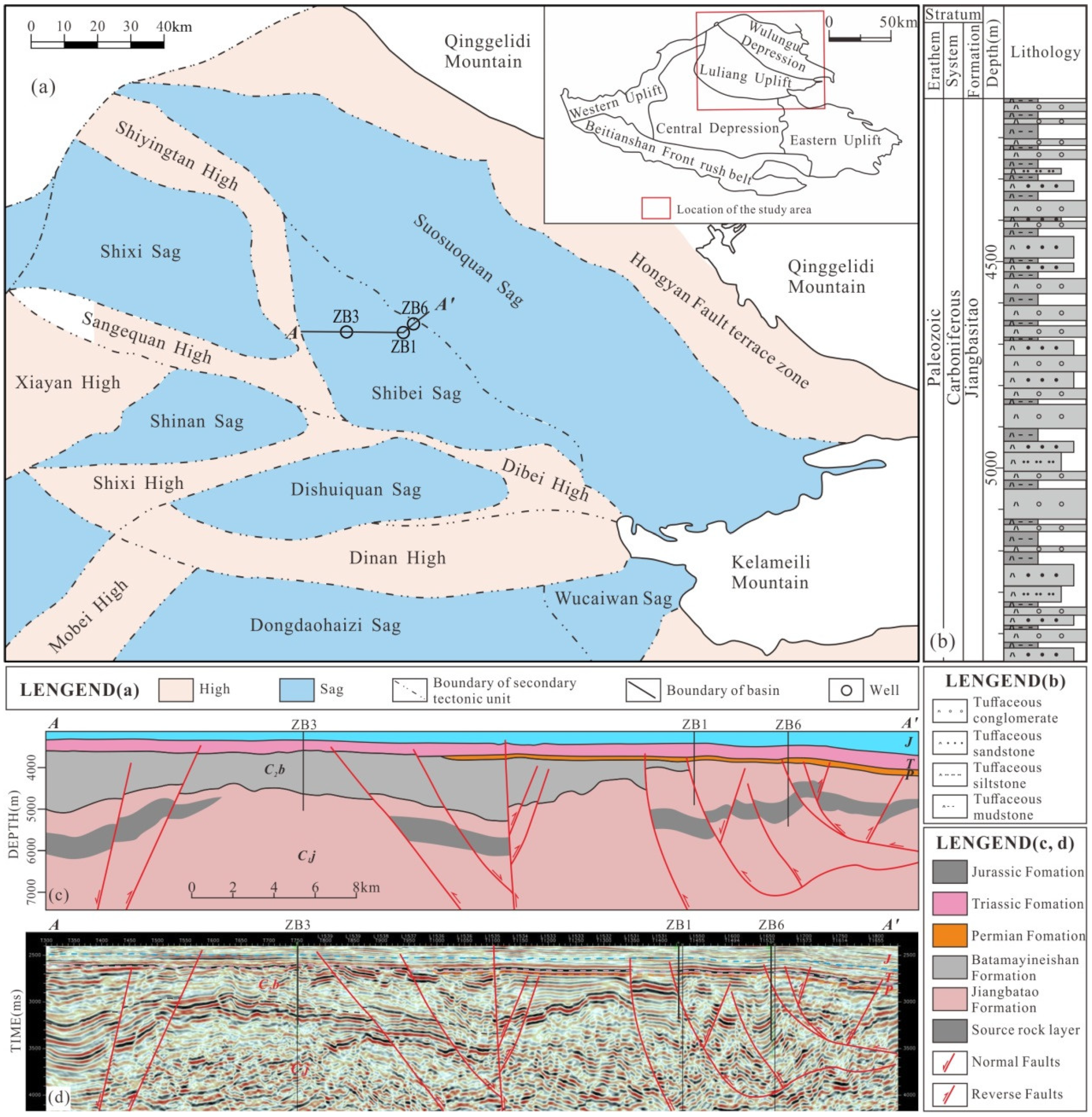
2. Geological Setting

After the closure of the Paleo-Asian Ocean in the Permian, the Junggar Basin evolved into a foreland basin [16] including the western uplift, the Bei Tianshan front rush belt, the eastern uplift, the central depression, the Luliang uplift and the Ulungu depression. The Shibei sag is located at the junction of the Ulungu depression and the Luliang uplift (Figure 1a), which is a secondary tectonic unit of the Ulungu depression [17]. The Junggar basin mainly developed during the opening-closing stages of a multicycle small ocean in the early Carboniferous associated with strong tectonic activity. Frequent earthquake events and volcanic eruptions were the main characteristics of this period. The Shibei sag developed mainly in an island arc tectonic setting [16] associated with frequent seismic activity, which had the tectonic background for the development of seismites.
The Carboniferous strata in the Shibei sag mainly meet two sets of strata, including the Lower Carboniferous Jiangbatao formation (C1j) and the Upper Carboniferous Batamayineishan formation (C2b) [18]. Among them, the Jiangbatao formation develops a set of high-quality dark mudstones with bathyal sedimentary background, which is the most favorable hydrocarbon source rock stratigraphy [16]. For this reason, the Shibei sag has good exploration prospects.
Early exploration of the Shibei sag was mainly aimed at the igneous reservoir near the fault zone. Well ZB1 and Well ZB3, respectively, encountered diabase and tuff in the Jiangbatao formation with better oil and gas display. However, the recently drilled Well ZB6 encountered thick conglomerate and sandstone instead of igneous rock (Figure 1b), which indicates that the reservoir types have a certain diversity. Well ZB6 is located between two large faults, and the bedding is characterized by a high angle due to the influence of fault activity (Figure 1c,d).

3. Materials and Methods

The field work was mainly aimed at studying the core drillings of Well ZB6 in the Shibei sag. The total length of the Carboniferous’s core is 25.91 m, mainly including 6.52 m tuffaceous conglomerate, 5.17 m tuffaceous sandstone, 3.72 m tuffaceous siltstone and 10.50 m tuffaceous mudstone. Among them, the continuous sedimentary thicknesses of the tuffaceous conglomerate, tuffaceous sandstone, tuffaceous siltstone and tuffaceous mudstone are 1.18–2.67 m, 1.66–3.51 m, 1.03–1.44 m and 0.71–4.51 m, respectively. The cores of Well ZB6 were recorded and sampled after detailed examination of sedimentary and deformation structures. Thirty-eight core photos were taken to analyze the typical identification characteristics of seismites. Thirty-five samples were collected for reservoir analysis. All the measurements and examinations were conducted in the State Key Laboratory of Petroleum Resources and Prospecting, China University of Petroleum (Beijing). The detection instrument used for reservoir property measurements is the U-MPP-1, a Chinese porosity and permeability tester, with a detection accuracy of 0.1%. The diameter and the length of the detected samples are 25 mm and 30 mm, respectively. Moreover, a Japanese Nikon polarizing microscope was used for the optical examinations of thin sections.

4. Results

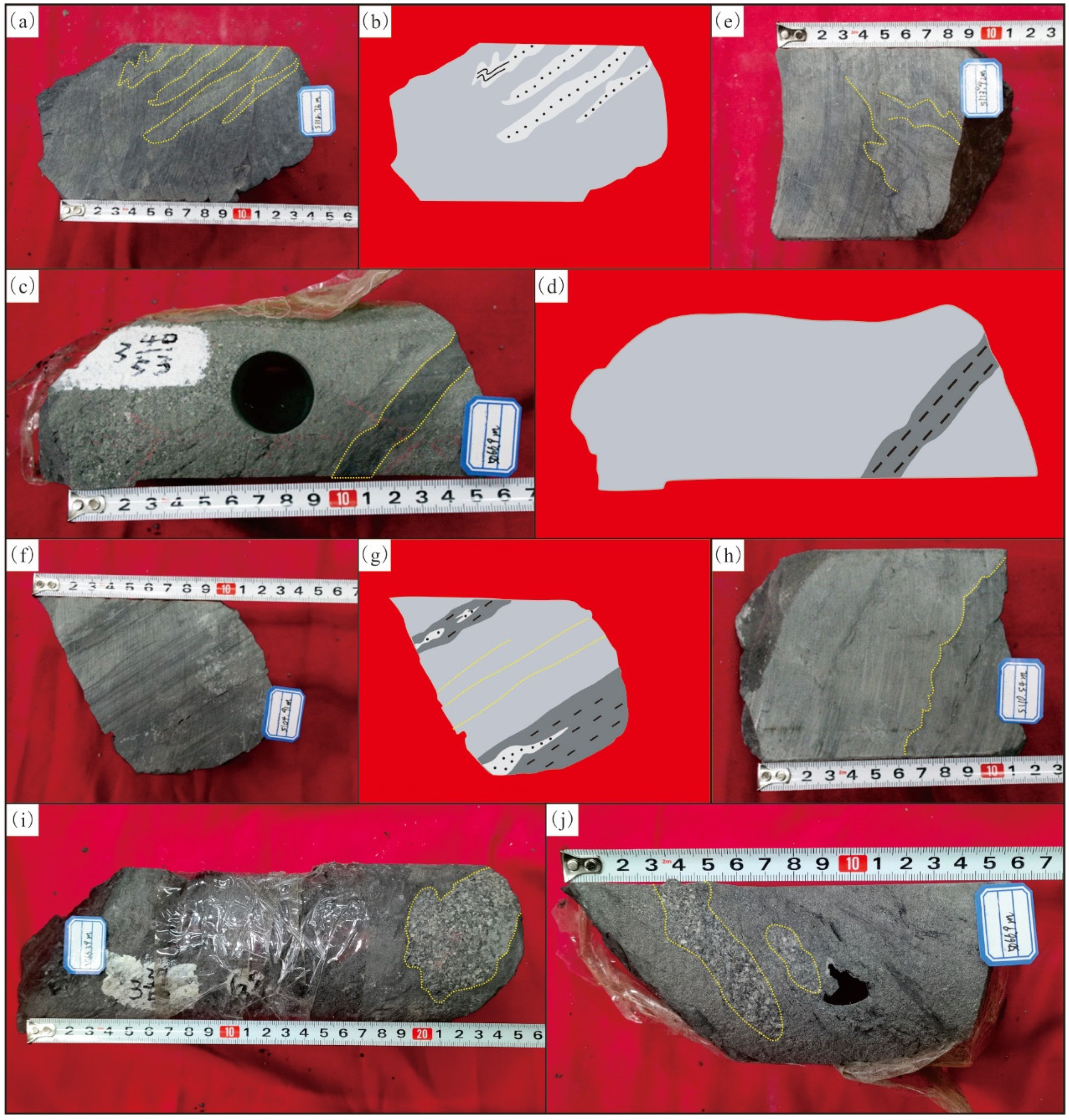
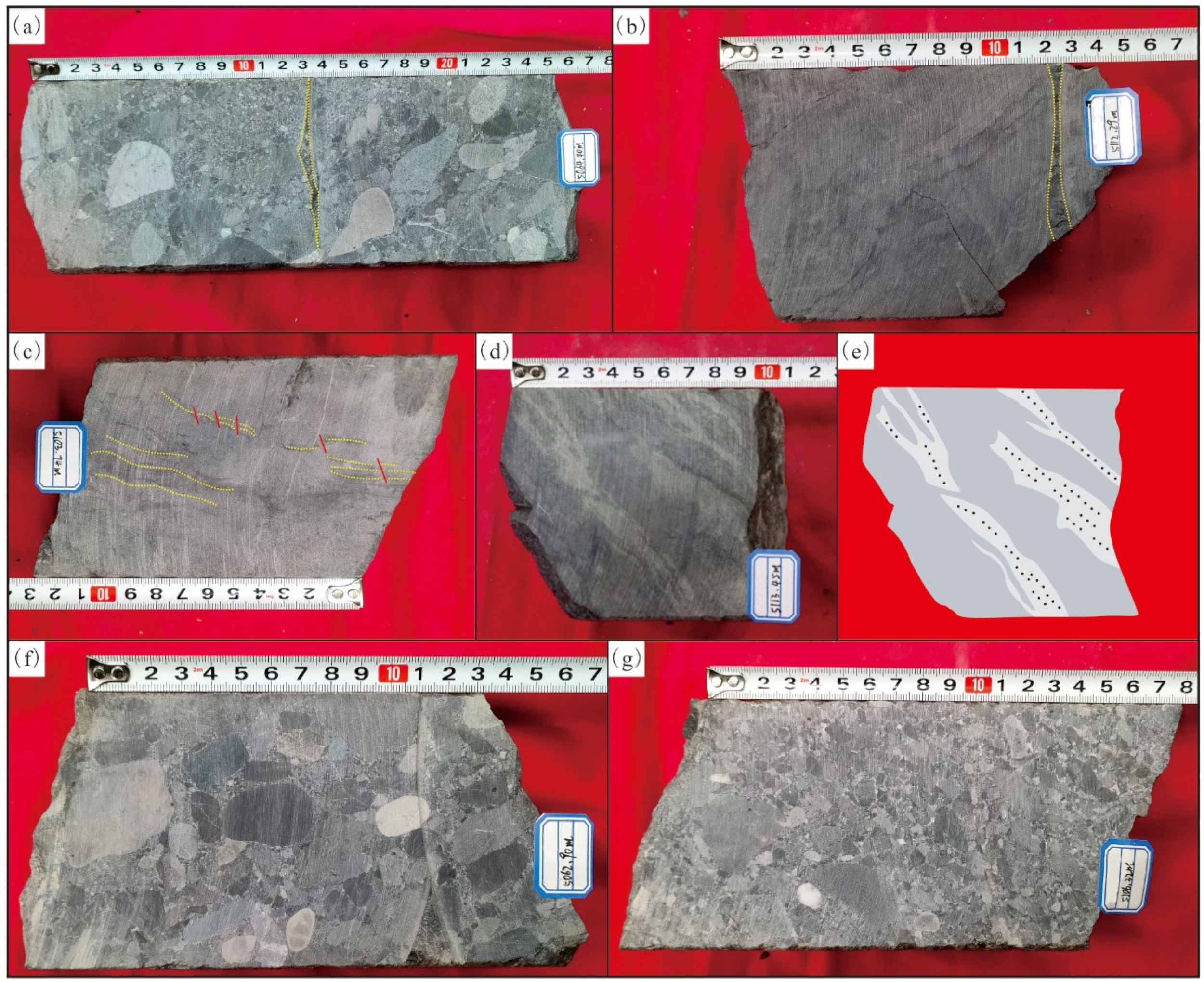
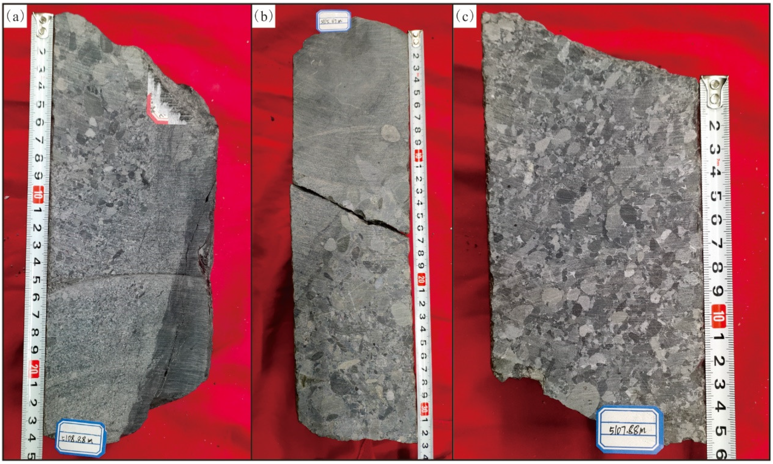
4.1. Identification Marks of Seismites

Previous authors have described many seismic deformation structures [10], but there is no standard description for some sedimentary structures [19,20]. It is generally applicable to identify seismites by liquefaction veins, namely liquefaction-crinkled deformation, flame structure, ball–pillow structure, stepped small fault, seismic breccia, etc. The degree of seismic structures is mainly controlled by the grain size of rock particles, and the seismic structures formed by different grain size components are also different.
Through systematic observation and analysis of core data from Well ZB6, a large number of typical signs of seismites were found in the thick tuffaceous conglomerate and sandstone. The multiple vertical superimposition of soft-sediment deformation layers and brittle deformation layers of a certain thickness in the rock stratum is generally associated with earthquakes [21]. This study suggests that the Carboniferous Jiangbatao formation developed seismites formed through earthquake activity. The soft-sediment deformation structures, brittle fracture structures and special rocks are provided explanation as follows.

4.1.1. Soft-Sediment Deformation Structures

Soft-sediment deformation structures, also known as plastic deformation structures [4], are the main identification mark of seismites [10]. Soft-sediment deformation is a series of liquefaction structures caused by seismicity and formed before sediment consolidation, which is mainly represented by changes in microbedding within the layer [5,22]. In the study area, there are four main types of liquefied veins: liquefaction-crinkled deformation structure, ball–pillow structure, flame structure and liquefaction breccia.

Liquefied Veins

As the most common soft-sediment deformation structure, clastic veins are a typical identification mark of the highest seismic liquefaction [12] and seismites [23]. They are often developed in sand–mudstone interbeds [10]. The sorted siltstone is most likely to be liquefied, and the liquefied veins are mostly irregularly curved, banded and intestinal-like in form. There are sandstone and mudstone veins, which are often distinguished from the surrounding rock by the difference in vein composition and color [24]. A liquefied sandstone vein is a soft sediment deformation vein structure.
Liquefied veins developed in the study area have different compositions due to the different grain sizes of the surrounding rocks. The vein body is silty or medium-fine sandy when the surrounding rock is mudstone or siltstone, respectively. The sandstone vein gradually pinches out along the extension direction of the rock stratum, and the vein body is approximately 1–2 cm in width. The sandstone vein cuts through the unconsolidated argillaceous surrounding rock and forms a concave bend at the end of the vein body (Figure 2a,b), which is called a plastic deformation fold [20]. The mudstone veins developed in the study area are rare, occasionally distributed in strips (1.5–2 cm in width), and relatively limited in distribution (Figure 2c,d).

Liquefaction-Crinkled Deformation Structure

A liquefaction-crinkled deformation structure is also known as a microwrinkle texture [20]. Liquefaction-crinkled deformation structures could be found in the thin mudstone and sandy mudstone interbedding and mainly refers to the small tight fold caused by the liquefaction of sediments. The axial plane of the fold is irregular, and the laminae are almost continuous. This structure is also known as a seismic fold [25]. The grain size of liquefied sandstone is mainly 0.01–0.3 mm [26]. The microwrinkle textures developed in the study area are limited to a single layer, with a small scale and a lateral extension of only 5 cm. The overlying and underlying layers are not affected by curl deformation (Figure 2e).

Ball–Pillow Structure

Ball–pillow structures are formed in the late stage of seismic liquefaction that often occur in the sand–mudstone interbed and are horizontally distributed. Under the condition of seismic shear stress, the liquefied sandy load’s body is separated from the parent rocks by gravitation and settles in the underlying fine-grained sedimentary unit at low density, forming a ball–pillow structure. The shape of a single ball–pillow structure is often diversified. In addition to the typical long axis directional arrangement and regularly nearly circular or elliptical spherical shape [3], it is can also develop a smaller and more irregular shape, which is referred to as the “tadpole shaped ball-pillow structure” [13]. This tadpole-shaped ball–pillow structure is mainly developed in the study area, which is about 0.7 cm thick and extends to both ends. The pillow body is flat (Figure 2f,g), which was elongated by seismic shear stress in the quasi-contemporaneous period.

Flame Structure

A flame structure is a kind of load deformation structure and often occurs at the lithologic interface between mud and sand. It is a type of deformation structure formed by differential compaction of overlying liquefied sandstone. In the study area, flame structures are distributed along the lithologic interface, with obvious flame tips that are approximately 0.5 cm high and more than 10 cm horizontally. The bottom surface of the sandstone layer in the flame structure presents a nodular bulge, which is called a load cast. The width of a single bulge is approximately 0.7–3 cm (Figure 2h). According to previous research results, a load structure with a scale of more than 1 cm may be associated with an earthquake [21], so it can be used as an identification mark for seismites.

Liquefaction Breccia

Liquefied breccia is a kind of plastic clastic breccia; some researchers believe that it is a kind of drainage structure [27], which is often associated with liquefied sandstone veins. It is a breccia formed by the penetration of consolidated mudstone from the underlying sandy liquefied veins [13] and belongs to in situ sedimentation. In the study area, liquefied breccia is sandwiched in tuffaceous mudstone of normal sedimentation. The gravel surface is characterized by curling and shrinking, and the lithology is coarse sandstone containing fine gravel (Figure 2i,j). Liquefied sandstone veins of the same lithology are developed within 50 cm of the underlying rock layer of the breccia, indicating that seismic liquefaction was extremely strong at this time.

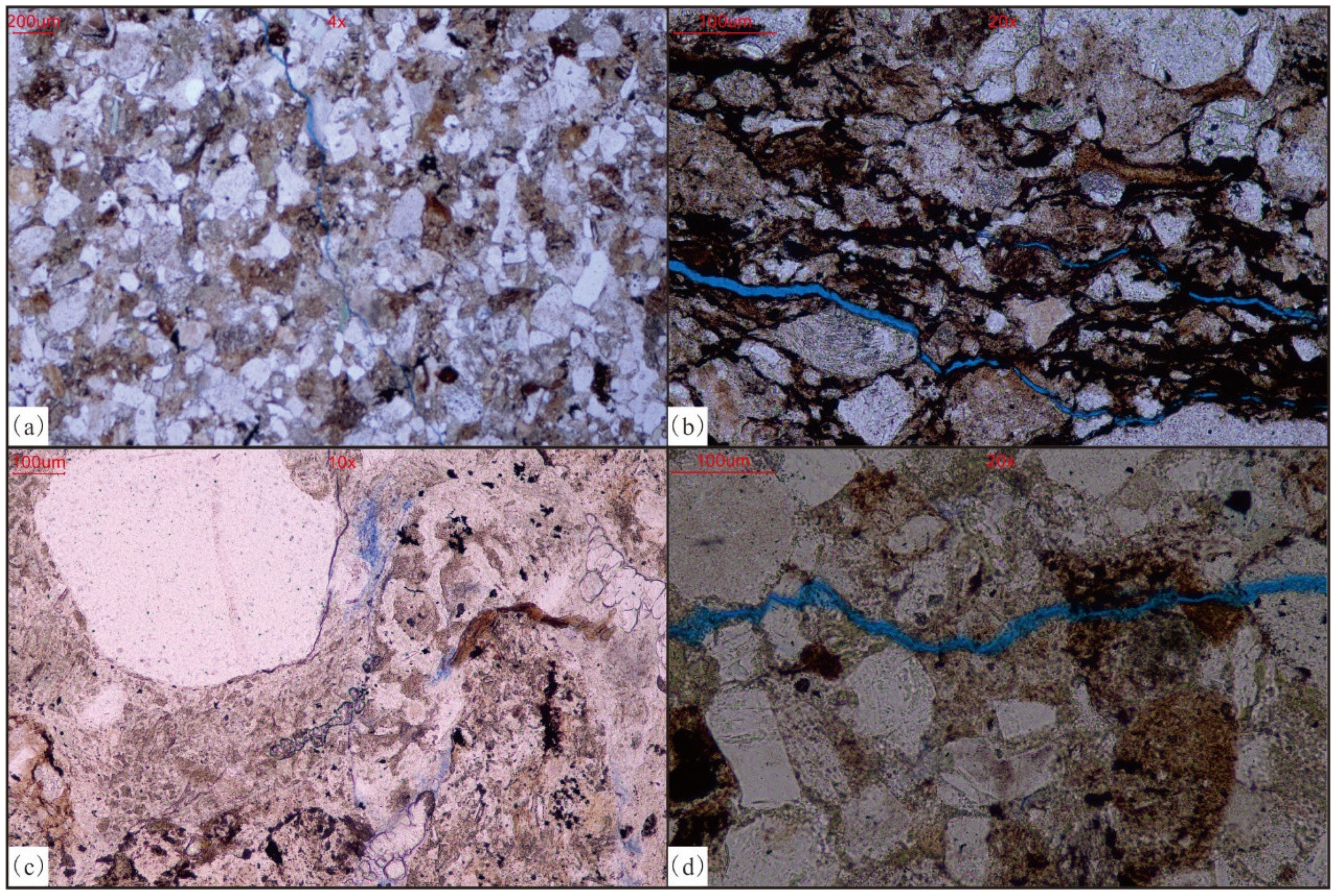
4.1.2. Brittle Fracture Structures

These structures are mainly caused by the fracture of consolidated rock under the various stress mechanisms associated with earthquakes [4,5]. Brittle fracture structures mostly include progressive fault layers, homogeneous fault layers, seismic fractures or ground fissures, synsedimentary microfractures and gravity faults [28]. In the study area, seismic fractures, synsedimentary microfractures and seismic-shattered rocks were mainly identified.

Seismic Fractures

Due to the different positions of fracture development, seismites can be divided into ground fissures formed on the surface of sediments, and seismic fractures formed inside sediments [29]. Seismic fractures are mainly tensile fractures, which are usually filled by overlying sand mudstone to form sand mudstone walls or liquefied veins; these are typically the result of liquefaction and seismic tensile stress. The fracture surface of seismic fractures developed in the study area is irregular and steep, showing a “V” shape pinching outward in the surrounding rock. The fracture extends to about 3.5–4.5 cm in length and 0.5–1.5 cm in width. Sandy filling can be seen inside the fracture, which was formed by the liquefied sandstone penetrating the overlying rock under the continuous action of an earthquake (Figure 3a). High-angle fractures that cut off the flame structure can also be seen, which are filled with mud (Figure 3b).

Synsedimentary Microfracture

Synsedimentary microfractures developed in the studied rocks include intraformational step faults and synsedimentary faults. The fault distance of the intraformational step faults is approximately 2–4 mm. The argillaceous laminae are pulled by the fault and bend. At the lower part of the fault, there are micro folds with wavy argillaceous laminae. The synsedimentary faults are mainly associated with liquefied sandstone veins, with a section width of approximately 3 mm, and sandy strips on both sides of the fault were spliced (Figure 3c–e).

Seismic-Shattered Rocks

These rocks were formed under strong seismic action during the diagenetic contemporaneous period and are often associated with seismic fractures [14]. In the study area, the tuffaceous conglomerate pebbles are well rounded, mostly supported by grains, and some pebbles are partially broken. Calcite veins cut through or surround the pebbles (Figure 3f,g), a formation called the molar tooth structure [30].

4.1.3. Seismic Grain-Supported Conglomerate

Both soft-sediment deformation structures and brittle fracture structures belong to in situ sedimentation. Under the influence of earthquakes, semi-consolidated sediment is displaced under the condition of terrain change, which can be divided into sliding and slumping according to the formation mechanism of classical gravity flow. According to the current research results, synsedimentary folds due to slumping are relatively common. Some scholars also classify such rocks with slumping structures as seismic turbidite [4] or seismic collapse rocks [12,30], which are typical allochthonous deposits. There are relatively few studies on the effect of sliding.
No typical slumping structure was found in the study area. However, a large number of inverse progressive beddings (Figure 4a,b) or inverse-positive progressive beddings (Figure 4c) were found in the thick conglomerate. The conglomerates are poorly sorted and well-rounded, and mainly supported by particles, which conforms to Walker’s typical characteristics of grain-supported conglomerate in a typical turbidite. In this study, it is named a seismic grain-supported conglomerate. It is an allochthonous gravity flow sedimentation type, in which semi-consolidated sediments formed by long-distance transport sedimentation are affected by sliding.

4.2. Petroleum Geological Significance

Due to the effect of seismic activity, the seismites have certain deformation, fragmentation and other characteristics and may be associated with allochthonous sliding deposits. It is generally believed that seismites may play a positive role in oil and gas transportation, the improvement of reservoir physical properties, and source–reservoir–cap assemblages [4,5,12,13]. A set of high-quality marine hydrocarbon source rocks is developed in the Carboniferous Jiangbatao formation of the Shibei sag, which provides favorable oil source conditions. At the same time, a series of igneous rocks and the here-described seismites are developed under the influence of island arc volcanic activity and have good reservoir conditions. However, the buried depth of the target layer is generally more than 4000 m; both igneous and sedimentary rocks are generally characterized by ultralow porosity and permeability. The matrix porosity is generally 1.24%–2.99%, the permeability is less than 0.1 × 10⁻³ μm2, making oil and gas exploration difficult. This study shows that the discovery of seismites has mainly two aspects of impact on the hydrocarbon accumulation conditions in the study area: improvement of reservoir performance and forming of favorable source–reservoir–cap assemblages.

4.2.1. Improvement of Reservoir Performance

Seismite reservoirs are significantly affected by vibration compaction. Through microscopic observation, it can be found that the particles have slipped, displaced, rearranged, and undergone plastic deformation and even brittle fracture. Microfractures have developed on the surface of quartz and feldspar particles (Figure 5a,b), and biotite is hydrated (Figure 5c). Microfractures, seismic fractures and liquefaction channels can connect pores (Figure 5a,b,d), which improve reservoir permeability [5]. At the same time, widely developed seismic fractures can be used as channel for fluid, thus enhancing dissolution around the fractures. Dissolution pores are mainly developed along the microfractures, indicating that the fluid used seismic fractures dissolving the surrounding feldspar particles, and to a certain extent, the permeability of the reservoir was improved. According to the actual measurement results, the porosity of the studied deposit is 1.9%–4.62%, with an average porosity of 2.95%, which is significantly improved compared with the matrix porosity.

4.2.2. Forming Favorable Source–Reservoir–Cap Assemblages
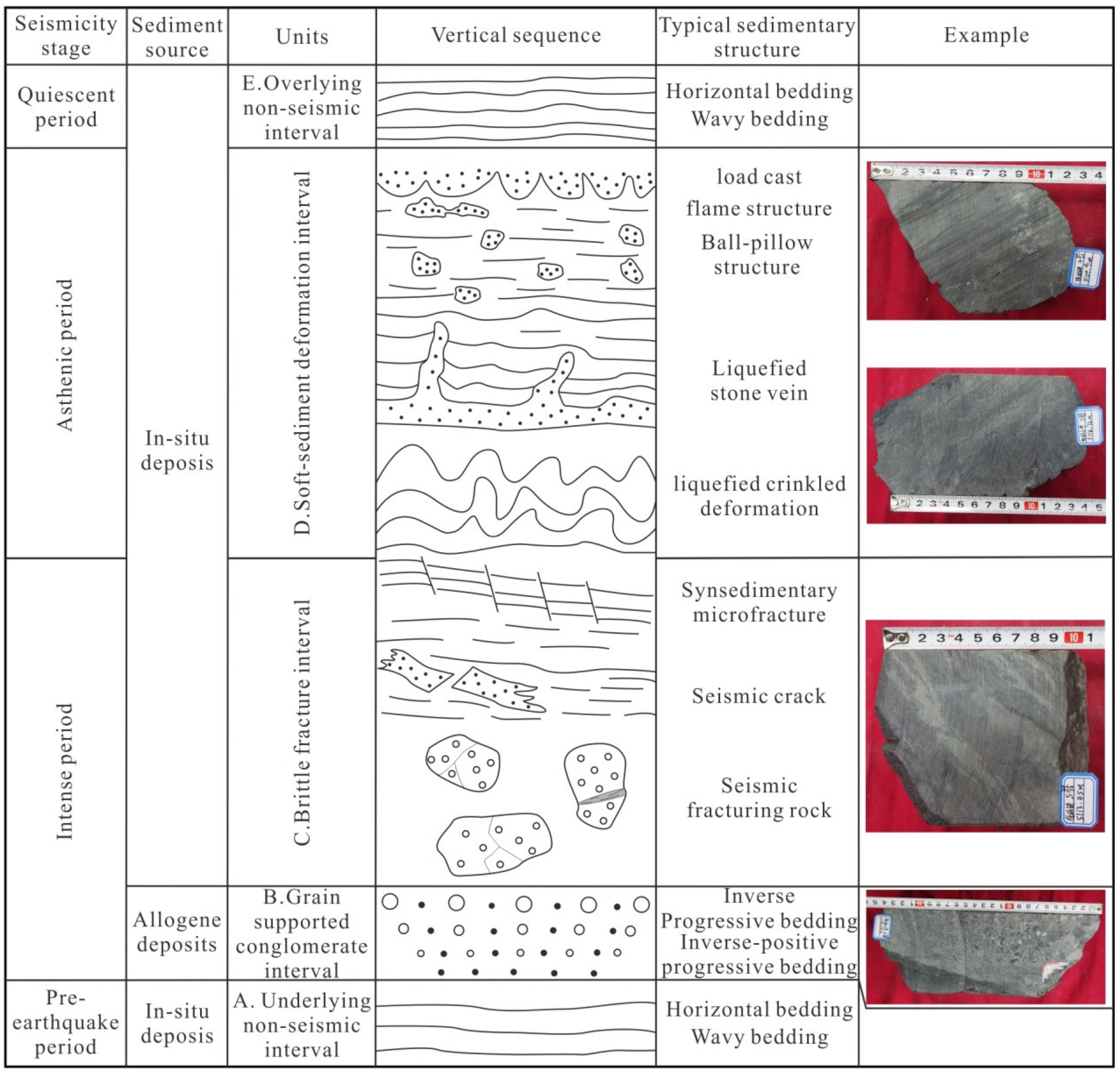
Due to seismic action, the unstable sediments slid to form coarse clastic sediments, such as seismic grain-supported conglomerate. Effectively configured with the hydrocarbon source rocks, favorable source–reservoir–cap assemblages can be developed. At the same time, the lenticular sedimentary body formed was revealed to be a favorable target for lithologic trap exploration.

5. Discussion

The development of seismites is associated with earthquakes, which can cause sliding, slumping, fragmentation and deformation of sediments [5]. Seismicity can generally be divided into four stages: pre-earthquake period, intense period, asthenic period and quiescent period. Sediment assemblages formed in different stages have certain rules in terms of vertical direction. In combination with the structural background and development characteristics of seismites in the Shibei sag, the vertical sequence of seismites was established, which can be divided into 5 intervals from bottom to top (Figure 6).

5.1. Underlying Non-Seismic Interval

This interval mainly develops in the pre-earthquake period, and the sedimentary strata are not affected by the earthquake. It is mainly characterized by horizontal bedding and wavy bedding.

5.2. Grain-Supported Conglomerate Interval

During this interval, semi-consolidated delta sediments deposited at high positions are transported by sliding under the influence of strong earthquakes. Brittle fracture structures develop in this interval, which suggests that this interval is the result of strong earthquakes. Therefore, this interval could represent the lower part of the seismite’s vertical sequence. Inverse progressive beddings and inverse-positive progressive beddings develop in this interval.

5.3. Brittle Fracture Interval

This interval mainly develops during the intense earthquake period. Under the influence of a strong earthquake, the seismic grain-supported conglomerate is transported here, and the mudstone deposited in situ is broken, forming a series of cracks. Seismic fractures and seismic-shattered rocks develop in the early stage of a strong earthquake, and the mudstone filling the fracture is liquefied. Due to the relatively weak earthquake intensity, synsedimentary microfractures develop in the later stage, which mainly develop in thinner rock layers and are associated with liquefaction-crinkled deformation and liquefaction veins.

5.4. Soft-Sediment Deformation Interval

This interval mainly develops in the asthenic period of the earthquake. The intensity of seismic activity gradually weakens, and the deformation amplitude of formation decreases. It is usually characterized by liquefaction-crinkled deformations, liquefaction veins and other sedimentary structures. Vertically, sandstone intrusion is dominant. Laterally, it is characterized by ball–pillow and flame structures.

5.5. Overlying Non-Seismic Interval

This interval mainly develops during the quiescent period of the earthquake. These beds seal beds with the seismites. As the seismic activity ends, the strata are not deformed. Horizontal beddings and wavy beddings are common.

6. Conclusions

(1)
Seismites were found in the Carboniferous formation of the Shibei sag, mainly developing typical identification marks such as soft-sediment deformation structures and brittle fracture structures. Among them, soft-sedimentary deformation structures mainly include five types: liquefied veins, liquefaction-crinkled deformation structures, ball–pillow structures, flame structures and liquefied breccia. Brittle fracture structures include three types: seismic fractures, synsedimentary microfractures and seismic-shattered rocks. Special rocks are mainly seismic grain-supported conglomerates formed by sliding.
(2)
The development characteristics of seismites in the Carboniferous formation are controlled by the seismic activity stage. From bottom to top, they can be divided into five intervals: underlying non-seismic interval, grain-supported conglomerate interval, brittle fracture interval, soft-sediment deformation interval and overlying non-seismic interval, forming a typical vertical sequence of seismites in the study area.
(3)
The discovery of seismites played a positive role in improving reservoir performance and forming favorable source–reservoir–cap assemblages.
(4)
The early exploration targets of the Carboniferous formation in the Shibei sag were mainly focused on igneous rocks. However, major exploration breakthroughs have not been made in this area. In this study, a new reservoir genetic type of seismites was discovered, which expanded the oil and gas exploration space and has a positive guiding significance for further exploration in this study area.

Author Contributions

Writing—original draft preparation, K.Z. and Y.W.; Methodology, G.Z.; Investigation, J.M.; Resources, W.X.; Data curation, S.W.; Writing—review and editing, T.X.; Funding acquisition, T.S. All authors have read and agreed to the published version of the manuscript.

Funding

This research was funded by Department of Science and Technology of Xinjiang Uygur Autonomous Region (grant number 2021D01A200) and China University of Petroleum-Beijing at Karamay (grant number XQZX20210003).

Acknowledgments

We sincerely appreciate the support of the research and innovation of hydrocarbon generation, reservoir formation and reservoir formation teams in the superimposed basin of China University of Petroleum (Beijing) at Karamay.

Conflicts of Interest

The authors declare no conflict of interest.

References

  1. Seilacher, A. Fault-graded beds interpreted as seismites. Sedimentology 1969, 13, 155–159. [Google Scholar] [CrossRef]
  2. Yu, Z.Y.; He, B.Z.; Qiao, X.F.; Jiao, C.L.; Cao, Z.C.; Wang, Z.; Chen, W.W.; Liu, S.L.; Qiu, H.B.; Yue, X.D. Seismites in the Early and Middle Silurian Strata of Shuntuoguole Area in Tarim Basin: Records of high-resolution tectonic events. Acta Geosci. Sin. 2016, 37, 313–325. [Google Scholar]
  3. Chen, Q.J.; Lu, T.Q.; Li, S.; Ma, T. Seismites in the Miocene at Tarim Basin Yecheng sag of West Kunlun Mountain piedmont and its geological significance. J. Palaeogeogr. 2021, 23, 142–152. [Google Scholar]
  4. Liu, J.N.; He, Y.B.; Wang, N.; Gu, Z.X.; Hao, T.; Liu, Y.W. Sedimentary characteristics and geological significance of earthquake events of Sha3 member in Huimin Sag, Jiyang Depression. Lithol. Reserv. 2020, 32, 14–23. [Google Scholar]
  5. Zhao, Q.F.; Zhang, J.G.; Kang, W.J.; Wang, S.Q.; Jiang, Z.X.; Du, K.F.; Huang, C.W. Characteristics of seismites and their geological significance of the upper fourth member of Shahejie Formation inWestern Sag, Liaohe Depression. Lithol. Reserv. 2019, 31, 24–33. [Google Scholar]
  6. Wu, X.T.; Yin, G.X. Features and significance of seismites from Upper Jurasic lacustrine deposites of Emei, Sichuan. Acta Sedimentol. Sin. 1992, 10, 19–26. [Google Scholar]
  7. Wang, C.Y.; Zheng, R.C.; Gao, Z.Z. The discovery and significance of seismites from the Lower Jurassic Badaowan Formation in Junggar Basin. Geol. Rev. 2008, 54, 821–826. [Google Scholar]
  8. Jiang, Y.Q. Characteristics and Origin of Dolomitic Rocks and Reservoir Controlling Parameters on the Fengcheng Formation from Wuxia Area, Junggar Basin. Master’s Thesis, Northwest University, Xi’an, China, 2012. [Google Scholar]
  9. Li, Y.H.; Liu, C.Y.; Wang, X.J. Discovery and significance of seismites in Late Tertiary Yanchang Formation of Ordos Basin. Acta Sedimentol. Sin. 2007, 26, 772–779. [Google Scholar]
  10. Sun, M.S.; Zhang, L.F.; Liu, C.Y.; Feng, C.J. Seismites characteristics and hydrocarbon geological significance of Triassic Yanchang Formation in Ordos Basin. J. Yanan Univ. 2021, 40, 61–66. [Google Scholar]
  11. Chen, W.J.; Yuan, J.; Li, H.Z.; Cao, Z.L.; Zhang, W.; Fan, H.L. Seismic deposition in Southwestern Qaidam Basin and its implication. Nat. Gas Geosci. 2010, 21, 230–237. [Google Scholar]
  12. Tan, X.F.; Jiang, W.; Wu, K.J.; Kuang, H.; Ran, T.; Wang, J.; Zhao, X.; Zhang, Q.X. Discovery and geological significance of seismites of the lower Ganchaigou Formation, the southwest margin of Qaidam Basin. Pet. Geol. Recovery Effic. 2016, 23, 11–19. [Google Scholar]
  13. Liu, Z.X.; Shao, Z.F.; Huang, L.; Wang, R.; Liu, J.J.; Zhao, B.; Zhang, W.X. Seismites of Cretaceous Qingshankou-Yaojia Formation and their petroleum geological significance in Songliao Basin. J. Northeast. Pet. Univ. 2021, 45, 73–84. [Google Scholar]
  14. Zhao, W.; Liu, J.N. Seismite in the Dainan Formation of the Fumin Oilfield in the Gaoyou Depression. Acta Geologica Sichuan 2018, 38, 236–238. [Google Scholar]
  15. Tang, W.B.; Xu, D.S.; Chen, H.D.; Chen, A.Q.; Liang, J.; Xiao, D.S. Discovery of seismites in the first member of the Kelaza Formation in central Taibei Sag of Tuha Basin and its geological significance. Oil Gas Geol. 2017, 38, 345–354. [Google Scholar]
  16. Ge, H.L. Volcanic Rocks Tectonic Setting and Source Rock Development Model in Batamayineshan Formation, Wulungu Area, Eastern Junggar Basin. Master’s Thesis, Jilin University, Changchun, China, 2020. [Google Scholar]
  17. Yu, H.Z. Comparison of the oil and gas sources in the Shibei Depression. Petrochem. Ind. Technol. 2019, 40, 85–86. [Google Scholar]
  18. Jiao, X.Q.; Zhang, G.L.; Niu, H.P.; Wang, S.Z.; Yu, H.Z.; Xiong, Z.R.; Zhou, J.; Gu, W.L. Genesis of Carboniferous volcanic rocks in northeastern Junggar Basin: New insights into the Junggar Ocean closure. Earth Sci. Front. 2022, 29, 385–402. [Google Scholar]
  19. Xu, D.J.; Qi, X.B.; Wu, Z.L. A review on the study of seismic rocks in continental lake basins in China. Sci. Technol. Inf. 2011, 17, 426–428. [Google Scholar]
  20. Zhang, T.S.; Chen, X.H.; Liu, Z.C. Seismites and their geological significance in Early Triassic of Southeast Sichuan Basin. Acta Sedimentol. Sin. 2012, 30, 477–489. [Google Scholar]
  21. Qiao, X.F.; Guo, X.P. Early Jurassic soft-sediment deformation interpreted as seismites in the Wuqia Pull-Apart Basin and the strike-slip Talas-Ferghana Fault, Xinjiang, China. Acta Geol. Sin. 2013, 87, 730–737. [Google Scholar]
  22. Moretti, M.; Sabato, L. Recognition of trigger mechanisms for soft-sediment deformation in the Pleistocene lacustrine deposits of the Sant Arcangelo Basin (Southern Italy): Seismic shocks vs. overloading. Sediment. Geol. 2007, 196, 31–46. [Google Scholar] [CrossRef]
  23. Qiao, X.F.; Li, H.B. Effect of earthquake and ancient earthquake on sediment. J. Palaeogeogr. 2009, 11, 593–610. [Google Scholar]
  24. Ezquerro, L.; Moretti, M.; Liesa, C.L.; Luzóna, A.; Simóna, J.L. Seismites from a well core of palustrine deposits as a tool for reconstructing the palaeoseismic history of a fault. Tectonophysics 2015, 655, 191–205. [Google Scholar] [CrossRef]
  25. Qiao, X.F.; Song, T.R.; Gao, L.Z.; Peng, Y.; Li, H.B.; Gao, L.; Song, B.; Zhang, Q.D. Seismites sequence in carbonate rocks by vibrational liquefaction. Acta Geol. Sin. 1994, 7, 243–265. [Google Scholar]
  26. Yang, B.; Zhang, C.M.; Li, S.H.; Du, J.Y.; Zhang, Z.T.; Zhu, R.; Yu, Y.; Yuan, R. Late Oligocene to Early Miocene paleoseismic records in Pearl River Mouth Basin and its hydrocarbon geological significance. Nat. Gas Geosci. 2014, 25, 834–847. [Google Scholar]
  27. Yin, X.L.; Yang, T.N. Seismites in the Laiyang Group in the Jiaozhou-Laiyang Basin, Shandong Province, and their tectonic implications. Geol. Rev. 2005, 51, 24–28. [Google Scholar]
  28. Du, Y.S.; Han, X. Seismo-deposition and Seismites. Adv. Earth Sci. 2000, 15, 389–394. [Google Scholar]
  29. Lin, S.G.; Zheng, R.C.; Liu, M.C.; Wang, C.Y. Formation mechanism and significance of continental clastic seismite. Nat. Gas Geosci. 2013, 24, 78–84. [Google Scholar]
  30. Li, H.; Tang, H.M.; Qin, Q.R.; Zhou, J.L.; Qin, Z.J.; Fan, C.H.; Su, P.D.; Wang, Q.; Zhong, C. Characteristics, formation periods and genetic mechanisms of tectonic fractures in the tight gas sandstones reservoir: A case study of Xujiahe Formation in YB area, Sichuan Basin, China. J. Pet. Sci. Eng. 2019, 178, 723–735. [Google Scholar] [CrossRef]
Figure 1. Tectonic location and geological section of the Shibei sag. (a) Tectonic location of the Shibei sag; (b) lithologic histogram of the Carboniferous formation of Well ZB6; (c) near-east–west geological profile of the Shibei sag; (d) near-east-west seismic profile of the Shibei sag.
Minerals 12 01560 g001
Figure 2. Soft-sediment deformation structures in the Carboniferous formation of the Shibei sag. (a) Well ZB6: well depth 5112.73 m, liquefied sandstone veins; (b) Well ZB6: well depth 5112.73 m, sketch of liquefied sandstone veins with the same region as (a); (c) Well ZB6: well depth 5066.90 m, liquefied mudstone vein; (d) Well ZB6: well depth 5066.90 m, sketch of liquefied mudstone vein with the same region as (c); (e) Well ZB6: well depth 5113.92 m, liquefaction crinkled deformation structure; (f) Well ZB6: well depth 5104.91 m, ball–pillow structure; (g) Well ZB6: well depth 5104.91 m, sketch of ball–pillow structure with the same region as (f); (h) Well ZB6: well depth 5110.54 m, flame structure; (i) Well ZB6: well depth 5066.39 m, liquefaction breccia; (j) Well ZB6: well depth 5066.90 m, liquefaction breccia.
Minerals 12 01560 g002
Figure 3. Brittle fracture structures in the Carboniferous formation of the Shibei sag. (a) Well ZB6: well depth 5064.40 m, seismic fractures; (b) Well ZB6: well depth 5112.29 m, seismic fractures; (c) Well ZB6: well depth 5103.74 m, synsedimentary microfracture; (d) Well ZB6: well depth 5113.45 m, synsedimentary microfracture; (e) Well ZB6: well depth 5113.45 m, sketch of synsedimentary microfracture with the same region as (d); (f) Well ZB6: well depth 5062.90 m, seismic shattered rocks; (g) Well ZB6: well depth 5106.32 m, seismic shattered rocks.
Minerals 12 01560 g003
Figure 4. Seismic grain-supported conglomerate in the Carboniferous formation of the Shibei sag. (a) Well ZB6: well depth 5108.88 m, inverse progressive beddings; (b) Well ZB6: well depth 5105.47 m, inverse progressive beddings; (c) Well ZB6: well depth 5107.88 m, inverse-positive progressive beddings.
Minerals 12 01560 g004
Figure 5. Micro-characteristics of seismite reservoir in the Carboniferous formation of the Shibei sag. (a) Well ZB6: well depth 5102.36 m, microfracture; (b) Well ZB6: well depth 5107.88 m, microfracture; (c) Well ZB6: well depth 5065.40 m, hydration of biotite and dissolution pores; (d) Well ZB6: well depth 5102.36 m, microfracture and dissolution pores.
Minerals 12 01560 g005
Figure 6. Stratigraphic sequences of seismites in the Carboniferous formation of the Shibei sag.
Minerals 12 01560 g006
Publisher’s Note: MDPI stays neutral with regard to jurisdictional claims in published maps and institutional affiliations.

