Green Infrastructure Planning in Metropolitan Regions to Improve the Connectivity of Agricultural Landscapes and Food Security


Abstract
:1. Introduction
2. Materials and Methods
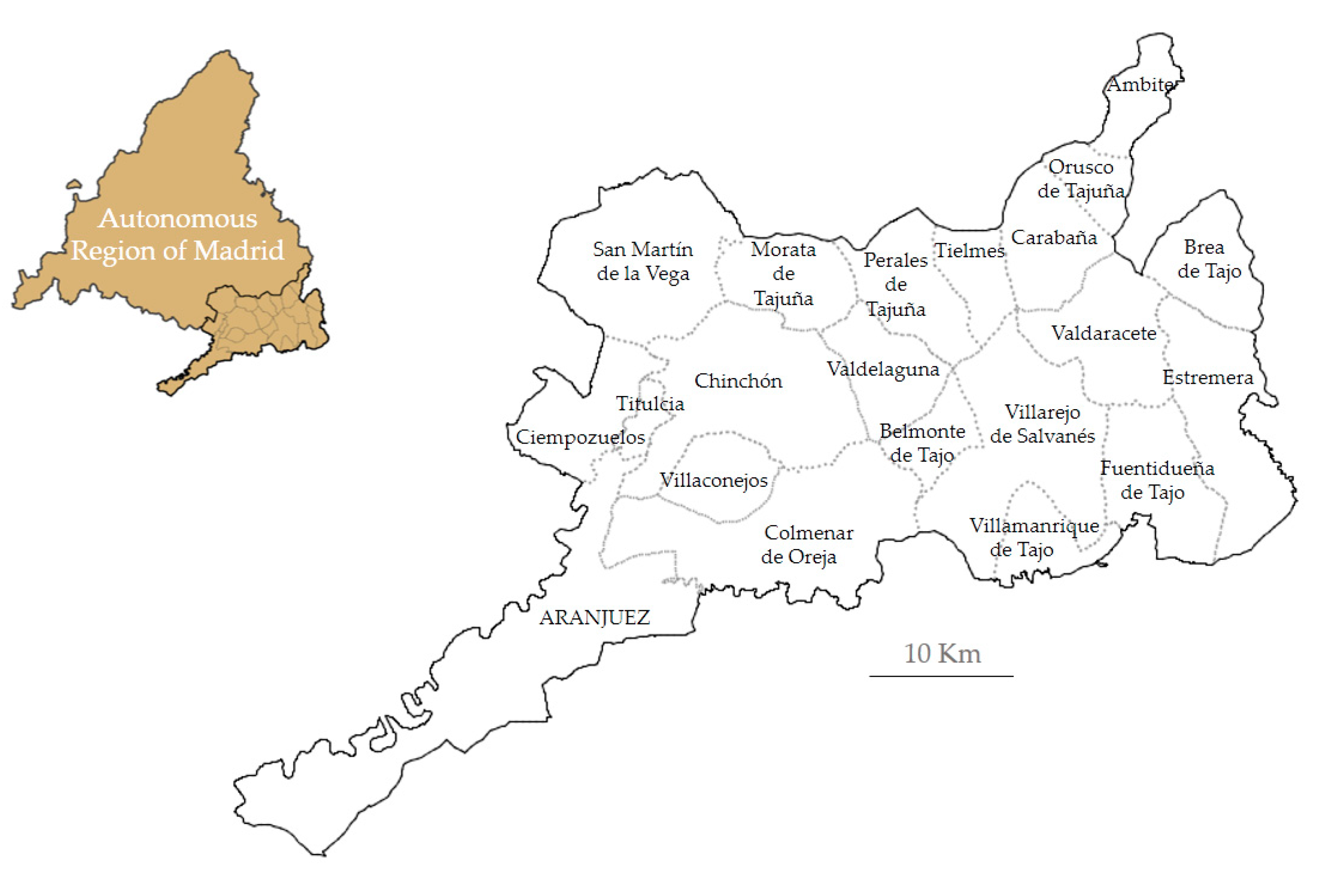
2.1. Study Area
2.2. Conceptual Framework
- GI implementation in agricultural landscapes requires reliable and flexible measures that suit farming practices and that are effectively communicated to farmers, ensuring better coordination and cooperation at a landscape level to enhance their effectiveness [20] (p.899).
- Reinforce the role of traditional agricultural landscapes that make up the territorial matrix into which the GI is integrated [18,19,20,21]. This is especially relevant in peri-urban areas under pressure from urban sprawl. Therefore, it is important to define an integrative multi-scale methodology to promote economically viable and environmentally sustainable agriculture.
- Promote new government frameworks that go beyond biodiversity protection in official natural parks and nature preserves, by promoting truly holistic GI development that is able to conserve the natural, cultural and landscape heritage as a whole.
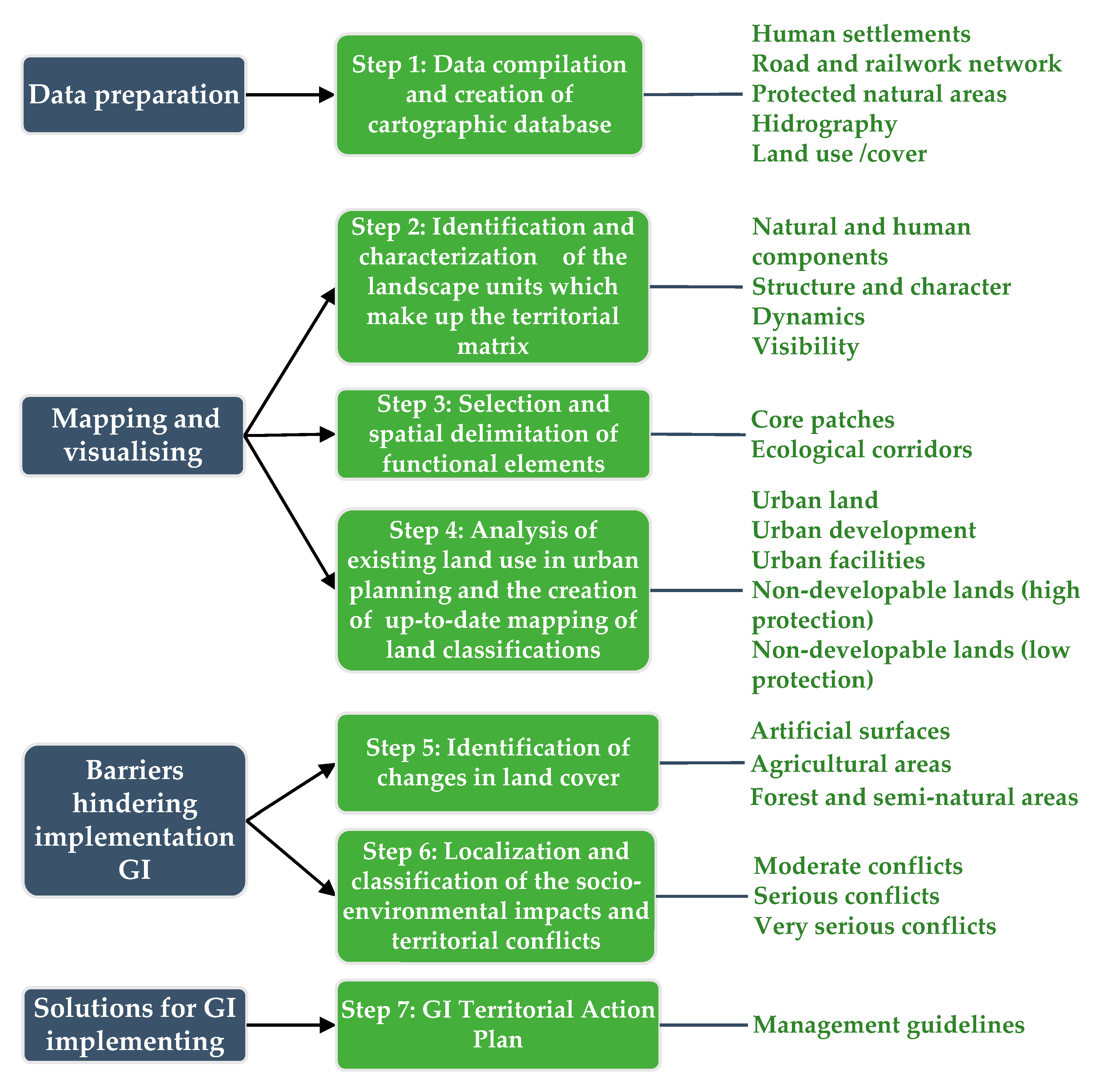
2.3. The Methodology Proposed for Mapping the GI
2.3.1. Mapping the GI Network
- Step 1: Data compilation and creation of a database that is sufficiently detailed to be used at a supra-municipal scale.
- Step 2: Identification and characterization of the landscape units which make up the territorial matrix of the selected study area.
- Natural and human components which make up the landscape: the physical and human features and elements which are best reflected in the morphology, functioning, and dynamics of the landscape are listed and described.
- The structure and character of the landscape: the different elements of the configuration of the unit are discursively articulated and integrated, leading to a reading of the character of the unit, the singularity of which stands out when compared to others.
- The dynamics of the landscape: the processes and active dynamics in each unit are identified and characterized using a historical analysis of the evolution of the landscape and its most recent transformations.
- The visibility of the landscape: the characteristics of the landscape are analyzed from a visual perspective, integrating the views on different levels which can be obtained from the landscape unit, incorporating the most significant visual features into the characteristics of each unit.
- Step 3: Selection and spatial delimitation of the functional elements for the formalization of the GI.
- Step 4: Analysis of existing land use in urban planning and the creation of up-to-date mapping of land classifications.
- Step 5: Identification of changes in land cover in the study area.
- Step 6: Localization and classification of the socio-environmental impacts and territorial conflicts
- Step 7: Creation of a GI Territorial Action Plan with management guidelines.
2.3.2. Mapping the Functional Elements in the GI
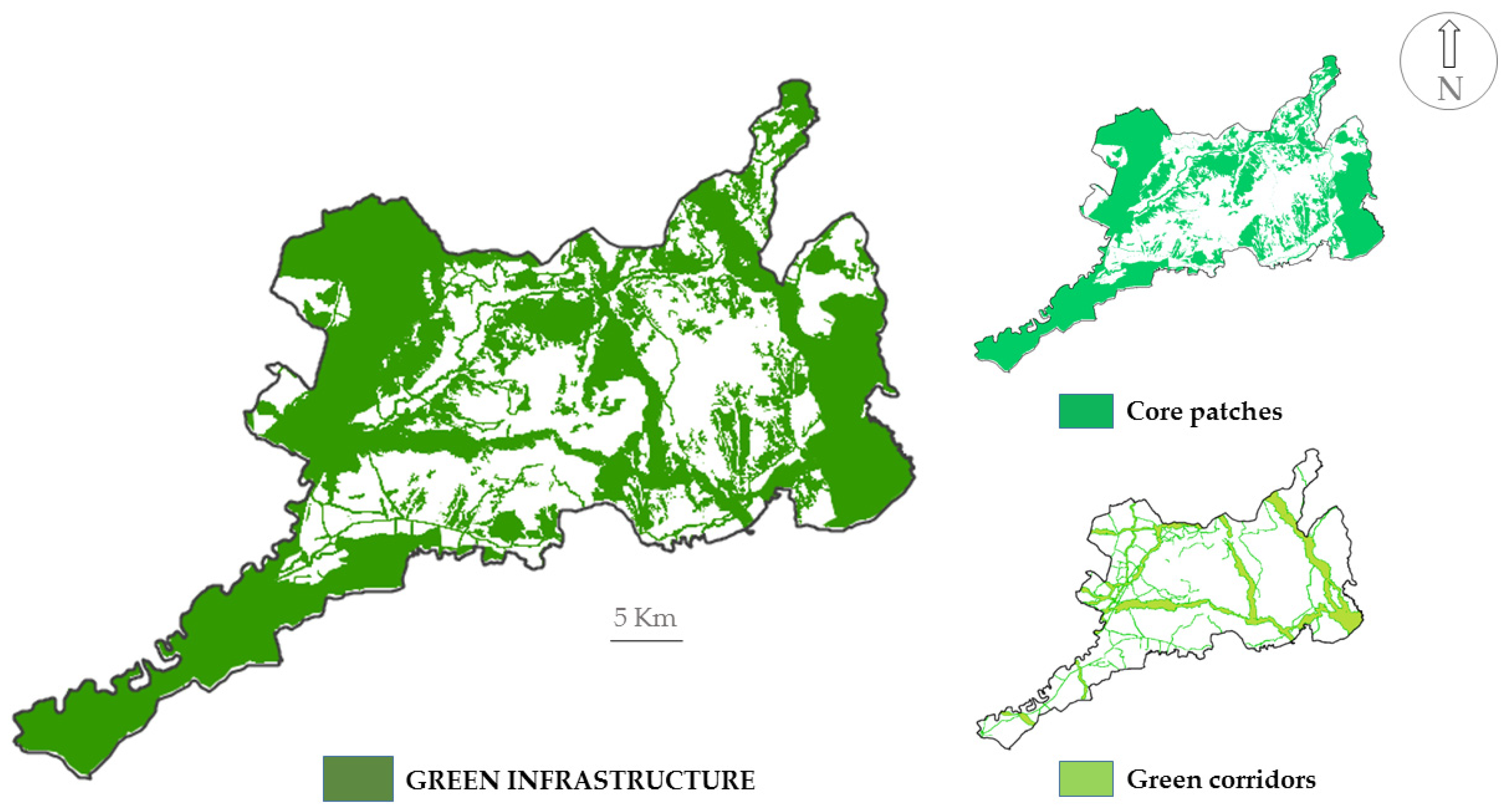
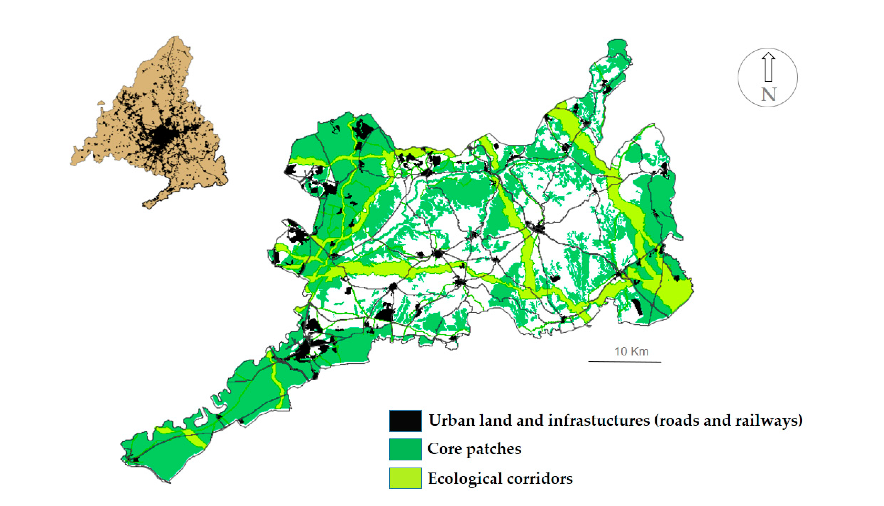
- Core patches: Are those spatial units in which the conservation of biodiversity is of prime importance for different species, even when dealing with areas which are not protected by law. They represent the anchorage to the network and can be of different shapes and sizes, as well as being both public and private areas: the Natural Protected Spaces, the Public Utility Forests and the Private Protected Forests have been used for the proposal for the formalization of the patches of GI as well as the spaces included in Natura 2000 network (ZEPAS, LIC/ZEC); the Community Interest Habitats; and complemented with agroecosystems of great significance, or those that lack sectorial protection, such as the Important Bird Areas (IBAs).
- Ecological corridors: The objective of these green corridors is to maintain ecological and environmental connectivity by using physical links between the core areas. As with the core patches, they are of different shapes and sizes—even though they are generally linear in nature—and they can also be publicly or privately owned. In the region studied, these primary corridors are complemented with secondary ones, such as water courses and the network of historical livestock routes.
- Territorial matrix: In accordance with the landscape ecological planning approach, the territorial matrix constitutes the spatial-temporal basis resulting from the physical medium, the biological component, their functional relationships, and the transformations which human activity introduces into the system, which is expressed in the specific configurations of the landscape. Therefore, it is important to highlight the fact that the effectiveness of the ecological network is not found to such a great degree in the spatial entity of the core patches and the corridors, but in its ability to interconnect different noteworthy elements of the territorial matrix which are important for environmental matters, landscape, heritage and production in order to guarantee the corresponding ecological, economic and environmental processes and flows.
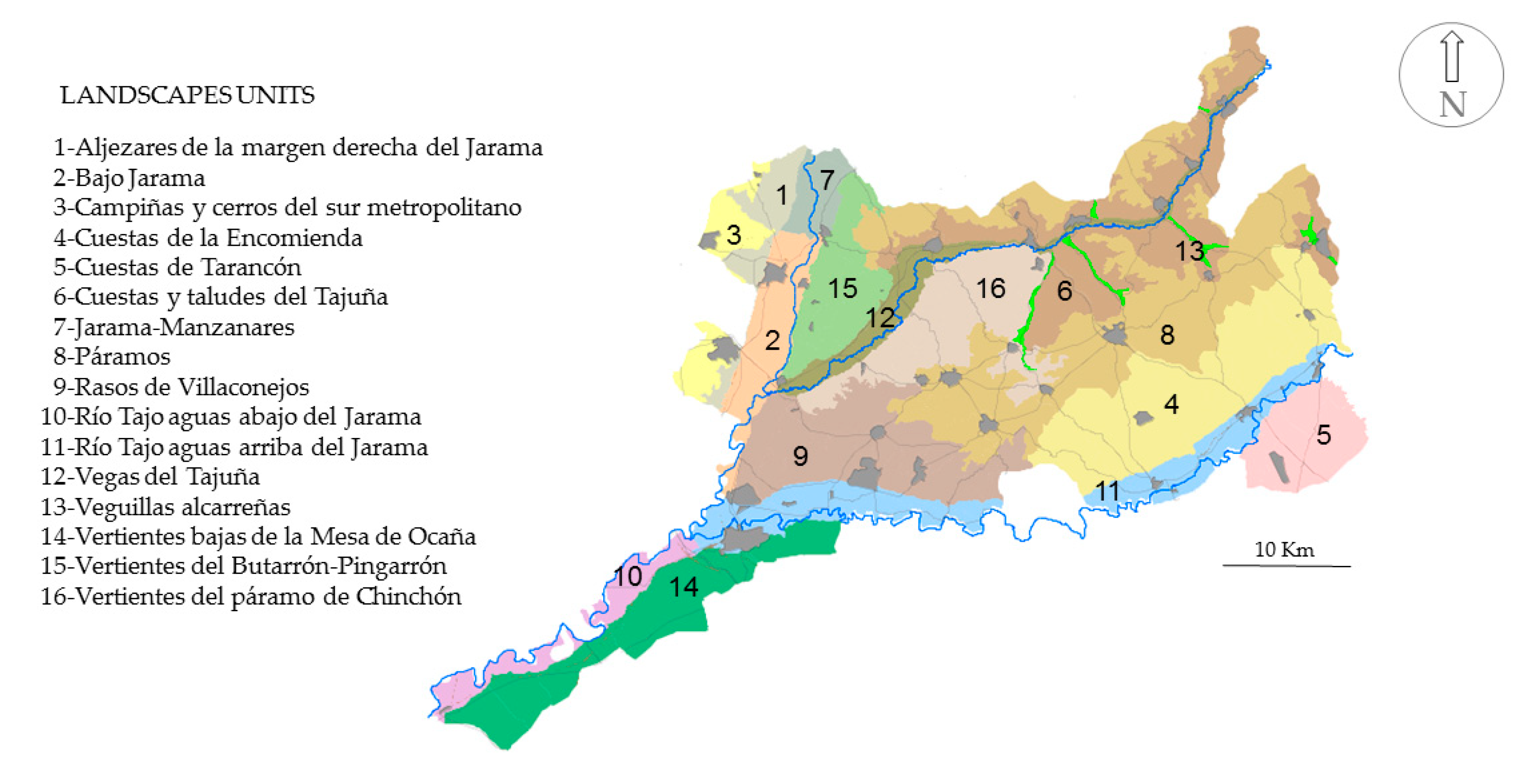
3. Results: Mapping the GI in the Comarca De Las Vegas
- Step 1: Data compilation and creation of a database that is sufficiently detailed to be used at a supra-municipal scale and Step 2: Identification and characterization of landscape units which make up the territorial matrix of the selected study area.
- Step 3: Selection and spatial delimitation of the functional elements for the formalization of GI
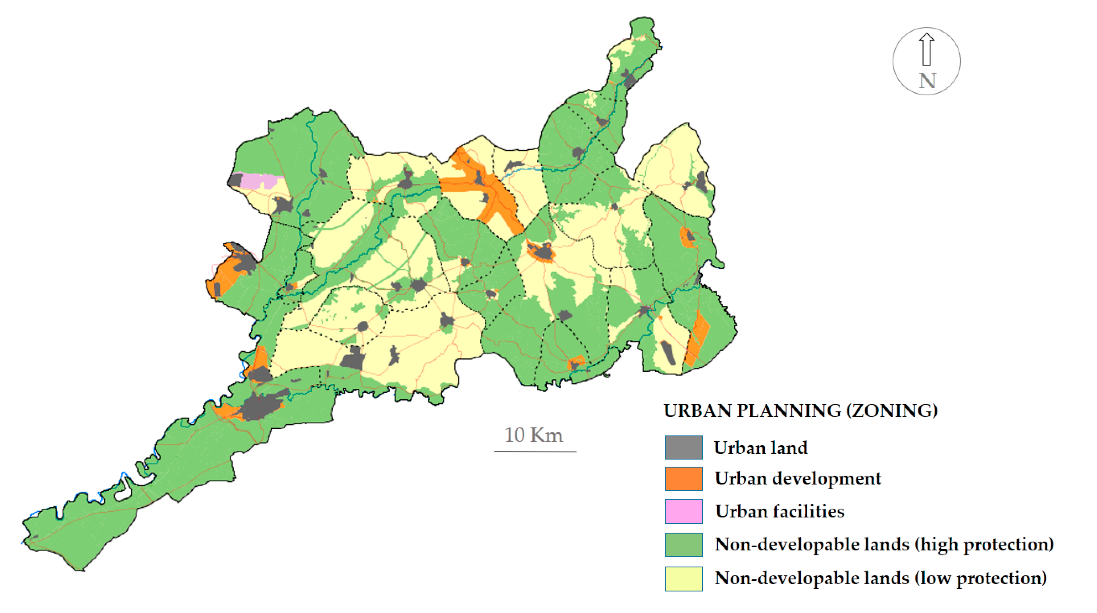
- Step 4: Analysis of existing land use in the urban planning and creation of up-to-date mapping
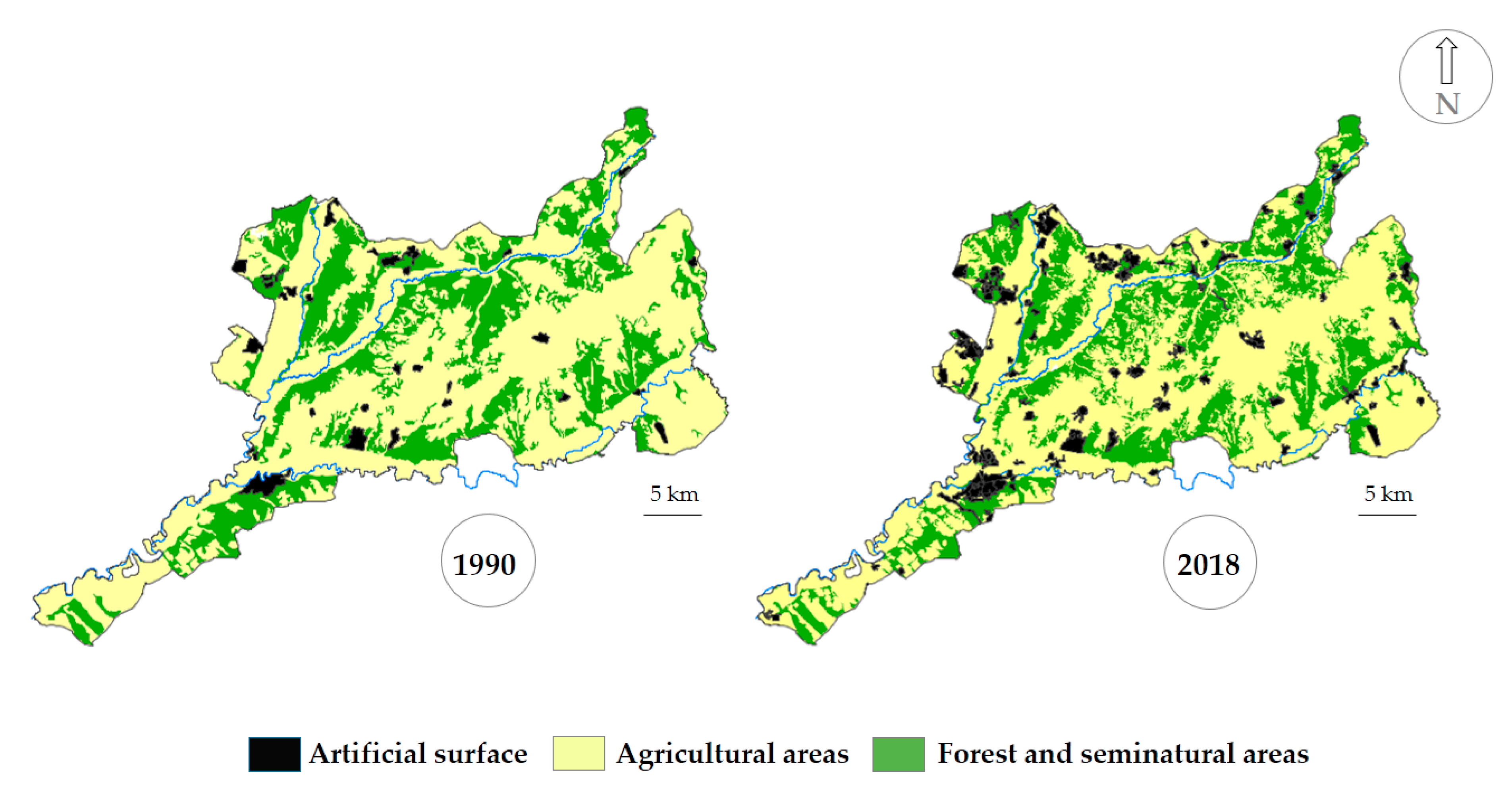
- Step 5: Identification of land-use changes
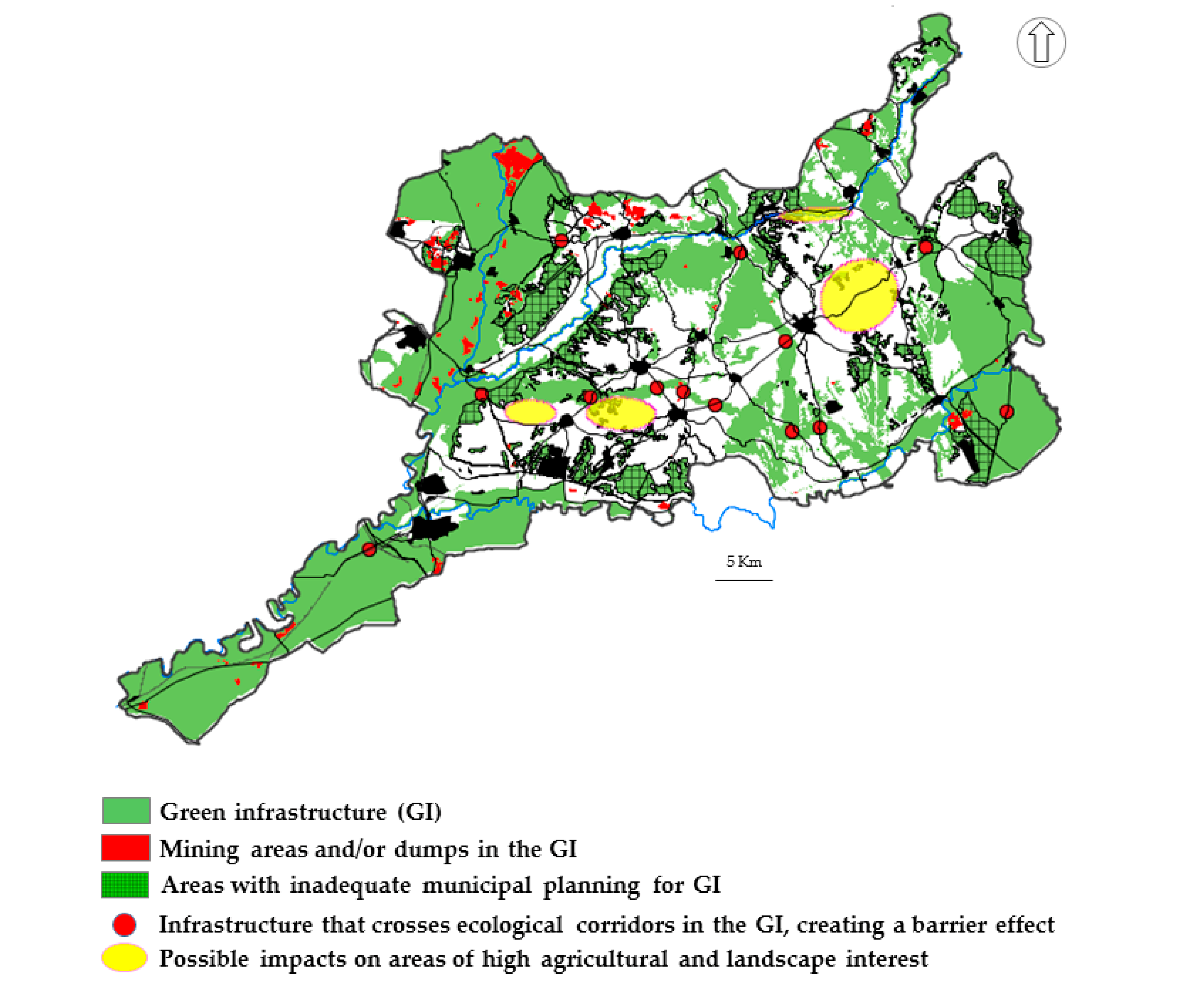
- Step 6: Localization and classification of the socio-environmental impacts and territorial conflicts that affect the state of conservation of the core patches and the connectivity of the primary and secondary corridors.
- Step 7: Creation of a Territorial Action Plan of the GI with management guidelines.
- Establishment of explicit protection for the GI proposed, with its different functional elements (core patches and ecological corridors), creating a specific planning category (Figure 4).
- The ecological corridors, regardless of their urban planning classification, must be defined and organized according to territorial and urban planning guidelines to guarantee functional and ecological connectivity.
- Incorporation of stricter regulations on agricultural land usage. Zoning designation should strictly limit any non-farming usage that competes with food production. Land-use planning should improve and protect valuable agricultural landscapes that form the matrix, without which the GI would not be able to perform its functions and provide ecosystem services (food provision, regulation, and cultural services).
- An increase in the level of protection of specific spaces, insisting that the environmental administrative bodies integrate these functional spaces into the regional or European network (Red Natura 2000) of protected natural spaces (for example, the Dehesa de Brea de Tajo; the Dehesa del Romeral in Aranjuez; Monte Valdealcalá, in Ambite and the IBA “Baja Alcarria” in Fuentidueña de Tajo, Estremera and Brea de Tajo).
- Creation of a series of specific measures to improve the GI functions aimed at the recovery of degraded land caused by mining activities, the regeneration of certain extremely valuable ecosystems found in core patches and limiting the expansion of forest land over farmland. Strategically siting new transportation facilities (road, railway, and metro networks) to prevent landscape fragmentation.
- Incorporation of a series of initiatives to activate the territory in terms of its landscape values and production capacity. By promoting policies for incentivizing local horticulture production and the stimulation of new generation farmers to contribute to the improvement of food self-sufficiency and food security and boosting endogenous development. Therefore, it seems important to create some small-scale agrarian parks and to encourage the adoption of different land stewardship contracts. Considering the agroecological characteristics and the agrarian landscape diversity of the Comarca de Las Vegas, the future agrarian parks could be situated in the vega media of the Tajuña, in the rasos of Villaconejos and Colmenar de Oreja and in the páramos of Valdaracete-Villarejo de Salvanés.
4. Discussion
5. Conclusions
Author Contributions
Funding
Conflicts of Interest
References
- Artmann, M.; Inostroza, L. Ecological indicators. Ecol. Indic. 2019, 96, 3–9. [Google Scholar] [CrossRef]
- Garzón, R. Hacia la reordenación del espacio libre a escala territorial: Nuevos paradigmas y análisis del planeamiento subregional andaluz. Ciudad Y Territorio Estud. Territ. 2019, 51, 63–80. [Google Scholar]
- Alexandru, A.; Razvan, M.; Andreea, D.; Lavinia, D.; Iulia, I. Methodological framework for urban sprawl control through sustainable planning of urban green infrastructure. Ecol. Indic. 2019, 96, 67–78. [Google Scholar] [CrossRef]
- European Commission. Communication from the Commission to the European Parliament, the Council, the European Economic and Social Committee and the Committee of the Regions: Green Infrastructure—Enhancing Europe’s Natural Capital. Publications Office of the European Union, Brussels. 2013. Available online: https://eur-lex.europa.eu/resource.html?uri=cellar:d41348f2-01d5-4abe-b817-4c73e6f1b2df.0014.03/DOC_1%26format=PDF (accessed on 14 September 2020).
- Kabisch, N.; Qureshi, S.; Haase, D. Human-environment interactions in urban green spaces—A systematic review of contemporary issues and prospects for future research. Environ. Impact Assess. Rev. 2015, 50, 25–34. [Google Scholar] [CrossRef]
- Kabisch, N.; Strohbach, M.; Haase, D.; Kronenberg, J. Urban green space availability in European cities. Ecol. Indic. 2016, 70, 586–596. [Google Scholar] [CrossRef]
- Bezák, P.; Mederly, P.; Izakovičová, Z.; Špulerová, J.; Schleyer, C. Divergence and conflicts in landscape planning across spatial scales in Slovakia: An opportunity for an ecosystem services-based approach in Slovakia: An opportunity for an ecosystem services-based approach? Int. J. Biodivers. Sci. Ecosyst. Serv. Manag. 2017, 13, 119–135. [Google Scholar] [CrossRef]
- Di Marino, M.; Tiitu, M.; Lapintie, K.; Viinikka, A.; Kopperoinen, L. Land use policy integrating green infrastructure and ecosystem services in land use planning. Results from two Finnish case studies. Land Use Policy 2019, 82, 643–656. [Google Scholar] [CrossRef]
- González, A.; Palomo, I.; González, J.A.; López, C.A.; Montes, C. Quantifying spatial supply-demand mismatches in ecosystem services provides insights for land-use planning. Land Use Policy 2020, 94, 104493. [Google Scholar] [CrossRef]
- Hansen, R.; Frantzeskaki, N.; Mcphearson, T.; Rall, E.; Kabisch, N.; Kaczorowska, A.; Artmann, M.; Pauleit, S. The uptake of the ecosystem services concept in planning discourses of European and American cities. Ecosyst. Serv. 2015, 12, 228–246. [Google Scholar] [CrossRef] [Green Version]
- Maes, J.; Lopes, A.L.; Baranzelli, C.; Zulian, G.; Batista e Silva, F.; Vandecasteele, I.; Hiederer, R.; Liquete, C.; Paracchini, M.L.; Mubareka, S.; et al. More green infrastructure is required to maintain ecosystem services under current trends in land-use change in Europe. Landsc. Ecol. 2015, 30, 517–534. [Google Scholar] [CrossRef] [Green Version]
- Vallecillo, S.; Polce, C.; Barbosa, A.; Perpiña, C.; Vandecasteele, I.; Rusch, G.; Maes, J. Spatial alternatives for green infrastructure planning across the EU: An ecosystem service perspective. Landsc. Urban Plan. 2018, 174, 41–54. [Google Scholar] [CrossRef]
- Mick, L.; Scott, M.J.; Collier, M.; Foley, K. The emergence of green infrastructure as promoting the centralization of a Landscape Perspective in spatial planning—The case of Ireland. Landsc. Res. 2016, 42, 146–163. [Google Scholar] [CrossRef]
- Parker, J.; Simpson, G. A Theoretical Framework for Bolstering Human-Nature Connections and Urban Resilience via Green Infrastructure. Land 2020, 9, 252. [Google Scholar] [CrossRef]
- Zuniga-Teran, A.A.; Gerlak, A.K.; Mayer, B.; Evans, T.P.; Lansey, K.E. Urban resilience and green infrastructure systems: Towards a multidimensional evaluation. Curr. Opin. Environ. Sustain. 2020, 44, 42–47. [Google Scholar] [CrossRef]
- Garmendia, E.; Apostolopoulou, E.; William, M.A.; Bormpoudakis, D. Biodiversity and green infrastructure in Europe: Boundary object or ecological trap? Land Use Policy 2016, 56, 315–319. [Google Scholar] [CrossRef] [Green Version]
- Kukkala, A.; Moilanen, A. Ecosystem services and connectivity in spatial conservation prioritization. Landsc. Ecol. 2017, 32, 5–14. [Google Scholar] [CrossRef] [PubMed] [Green Version]
- Feria, J.M.; Santiago, J. The notion of green infrastructure and its potential aplication to metropolitan spatial planning. In El reto de la Planificación y Observación Territorial en Iberoamérica para el siglo XXI: Dinámicas, Procesos, Experiencias y Propuestas; Centro de Estudios Geográficos y la Universidad de Lisboa: Lisboa, Portugal, 2015. [Google Scholar]
- Roc, P.; La Rota-Aguilera, M.J.; Giocoli, A.; Cirera, J.; Coll, F.; Pons, M.; Pino, J.; Pili, S.; Serrano, T.; Villalba, G.; et al. Assessing the sustainability of contrasting land use scenarios through the socioecological integrated analysis (SIA) of the metropolitan green infrastructure in Barcelona. Landsc. Urban Plan. J. 2020, 203. [Google Scholar] [CrossRef]
- Schmidt, J.; Hauck, J. Implementing green infrastructure policy in agricultural landscapes—Scenarios for Saxony-Anhalt, Germany. Reg. Environ. Chang. 2018, 18, 899–911. [Google Scholar] [CrossRef]
- Yacamán, C.; Mata, R. Infraestructura verde, un instrumento renovador para mejorar la resiliencia urbana. Una propuesta para el sur metropolitano de Madrid. In XXV Congreso de La AGE. 50 Años de Congreso de Geografía. Naturaleza, Territorio y Ciudad En Un Mundo Global; Allende, F., Cañada, R., Fernández, G., Gómez, G., López, N., Palacios, A., Eds.; UAM Ediciones: Madrid, Spain, 2017; pp. 579–588. [Google Scholar] [CrossRef]
- Meerow, S.; Newell, J.P.; Stults, M. Defining urban resilience: A review. Landsc. Urban Plan. 2016, 147, 38–49. [Google Scholar] [CrossRef]
- Agency European Environment. Urban Sprawl in Europe (Joint EEA-); Publication Office of the European Union: Luxemburg, 2016.
- Hennig, E.; Schwick , C.; Soukup, T.; Orlitová, E.; Kienast, F.; Jaeger, J. Multi-Scale Analysis of Urban Sprawl in Europe: Towards a European de-Sprawling Strategy. Land Use Policy 2015, 49, 483–498. [Google Scholar] [CrossRef] [Green Version]
- Brueckner, J.K. Urban sprawl: Diagnosis and remedies. Int. Reg. Sci. Rev. 2000, 23, 160–171. [Google Scholar] [CrossRef]
- Yacamán, C.; Mataran, A.; Mata, R.; López, J.M.; Fuentes, R. The potential role of short food supply chains in strengthening periurban agriculture in Spain: The cases of Madrid and Barcelona. Sustainability 2019, 11, 2080. [Google Scholar] [CrossRef] [Green Version]
- Rounsevell, M.D.; Pedroli, B.; Erb, K.-H.; Gramberger, M.; Busck, A.G.; Haberl, H.; Kristensen, S.; Kuemmerle, T.; Lavorel, S.; Lindner, M.; et al. Challenges for land system science. Land Use Policy 2012, 29, 899–910. [Google Scholar] [CrossRef]
- Clemens, D.; Hennersdorf, J.; Lehmann, I.; Reißmann, D. Data envelopment analysis of urban efficiency—Interpretative methods to make DEA a heuristic tool. Ecol. Indic. 2018, 84, 607–618. [Google Scholar] [CrossRef]
- Borelli, S.; Chen, Y.; Conigliaro, M.; Salbitano, F. Green infrastructure: A new paradigm for developing cities. In Proceedings of the World Forestry Congress Conference Paper, Durban, South Africa, 7–11 September 2015. [Google Scholar] [CrossRef]
- Gurrutxaga, M.; Marull, J.; Domene, E.; Urrea, J. Assessing the integration of landscape connectivity into comprehensive spatial planning in Spain. Landsc. Res. 2015, 40, 817–833. [Google Scholar] [CrossRef]
- Arcidiacono, A.; Ronchi, S.; Salata, S. Managing multiple ecosystems services for lanscape conservation: A Green infrastructure in Lombardy Region. Procedia Eng. 2016, 161, 2297–2303. [Google Scholar] [CrossRef] [Green Version]
- Vera, F.; Olcina, J.; Sainz, A. La incorporación de la infraestructura verde en la Ordenación Territorial. El Plan de Acción Territorial de la Infraestructura Verde del litoral de la Comunidad Valenciana, PATIVEL. Ciudad Y Territ. Estud. Territ. 2019, 201, 467–490. [Google Scholar]
- Feria, J.M.; Santiago, J. Nature and the city. Prospects for the Integration of green infrastructure in Spanish metropolitan plans. Boletín De La Asoc. De Geógrafos Españoles 2017, 74, 539–544. [Google Scholar] [CrossRef]
- Lennon, M. Green infrastructure and planning policy: A critical assessment. Local Environ. 2015, 20, 957–980. [Google Scholar] [CrossRef] [Green Version]
- Mell, I.; Allin, S.; Reimer, M.; Wilker, J. Strategic green infrastructure planning in Germany and the UK: A transnational evaluation of the evolution of urban greening policy and practice. Int. Plan. Stud. 2017, 22, 333–349. [Google Scholar] [CrossRef] [Green Version]
- Yacamán, C.; Matarán, A.; Mata, R.; Macías, Á.; Torres, A. Peri-Urban Organic Agriculture and Short Food Supply Chains as Drivers for Strengthening City/Region Food Systems—Two Case Studies in Andalucía, Spain. Land 2020, 9, 177. [Google Scholar] [CrossRef]
- Council of Europe. European Landscape Convention; Council of Europe: Florence, Italy, 2000; Available online: http://conventions.coe.int/Treaty/en/Treaties/Html/176.htm (accessed on 2 September 2020).
- Mata, R.; Mato, J.F. Los regadíos históricos del Tajuña. Río Tajo. In Los Regadíos Históricos Españoles: Paisajes Culturales, Paisajes Sostenibles Madrid; Ministerio de Medio Ambiente, Medio Rural y Marino: Madrid, Spain, 2010; pp. 329–364. [Google Scholar]
- Abad, L. Gobernanza en espacios periurbanos a través de la iniciativa europea LEADER. El caso de la comarca madrileña de Las Vegas. Anales de Geografío de la Universidad Complutense de Madrid 2014, 34, 9–32. [Google Scholar] [CrossRef] [Green Version]
- Valenzuela, M. La residencia secundaria en ámbitos metropolitanos: La Comunidad de Madrid. Estudios Turísticos 2003, 155–156, 112–157. [Google Scholar]
- Molina, P.; Sanz, C. Vegas históricas y nuevos regadíos del Tajo-Jarama en torno a Aranjuez. In Atlas de Los Paisajes Agrarios de España; Molinero, F., Ed.; Ministerio de Agricultura, Alimentación y Medio Ambiente (MAGRAMA): Madrid, Spain, 2013; pp. 615–626. [Google Scholar]
- Mata, R.; Yacamán, C.; Ferrer, D. La Infraestructura Verde (IV) como Concepto y Herramienta de Planificación Ecológica y Territorial Estratégica. Estado de la Cuestión en el Ámbito Científico, Normativo y Aplicado; Scientific Report. Research Project Paisaje y Huerta de Madrid; (PDRR-I8 Agreement Autonomous University-IMIDRA). Rural Development Programme 2014–2020. 2020, unpublished. Available online: https://www.researchgate.net/publication/264321991_Infraestructuras_y_avance_de_la_frontera_agricola_en_el_Parque_Nacional_de_Cotapata_Bolivia_Aplicacion_de_las_tecnologias_de_la_informacion_geografica (accessed on 14 September 2020).
- Haaland, C.; Van den Bosch, C. Urban forestry & urban greening challenges and strategies for urban green-space planning in cities undergoing densification: A review. Urban For. Urban Green. 2015, 14, 760–771. [Google Scholar] [CrossRef]
- Wilker, J.; Rusche, K.; Rymsa, C. Improving participation in green infrastructure planning. Plan. Pract. Res. 2016, 31, 229–249. [Google Scholar] [CrossRef]
- Martín, B.; Montes, C. Restoring the human capacity for conserving biodiversity: A social–ecological approach. Sustain. Sci. 2015, 10, 699–706. [Google Scholar] [CrossRef]
- Termorshuizen, J.; Opdam, P. Landscape services as a bridge between landscape ecology and sustainable development. Landsc. Ecol. 2009, 24, 1037–1052. [Google Scholar] [CrossRef]
- Mata, R.; Galiana, L.; Allende Álvarez, F.; Fernández, S.; Lacasta, P.; López, N.; Molina, P.; Sanz, C. Evaluación del paisaje de la Comunidad de Madrid: De la protección a la gestión territorial. Urban 2009, 14, 34–57. [Google Scholar]
- Crofts, R. Linking protected areas to the wider world: A review of approaches. J. Environ. Policy Plan. 2004, 6, 143–156. [Google Scholar] [CrossRef]
- Gurrutxaga, M.; Lozano, P.J.; Del Barrio, G. GIS-based approach for incorporating the connectivity of ecological networks into regional planning. J. Nat. Conserv. 2010, 18, 318–326. [Google Scholar] [CrossRef]
- Verburg, P.H.; Van de Steeg, J.; Veldkamp, A.; Willemen, L. From land cover change to land function dynamics: A major challenge to improve land characterization. J. Environ. Manag. 2009, 90, 1327–1335. [Google Scholar] [CrossRef] [PubMed]
- Kuemmerle, T.; Levers, C.; Erb, K.; Estel, S.; Jepsen, M.; Müller, D.; Plutzar, C.; Stürck, J.; Verkerk, P.J.; Verburg, P.H.; et al. Hotspots of land use change in Europe. Environ. Res. Lett. 2016, 11, 1–14. [Google Scholar] [CrossRef]
- Valladares, F.; Gil, P.; Forner, A. Bases Científico-Técnicas Para La Estrategia Estatal de Infraestructura Verde y de La Conectividad y Restauración Ecológicas; Ministerio de Agricultura y Pesca, Alimentación y Medio Ambiente: Madrid, Spain, 2017. [Google Scholar]
- Mata, R.; Ferrer, D.; Yacamán, C. Caracterización del Paisaje de la Comarca de las Vegas. Scientific Report. Research Project Paisaje y Huerta de Madrid. (PDRR-I8 Agreement Autonomous University-IMIDRA). Rural Development Program 2014–2020; Madrid, Spain. 2019, unpublished. Available online: https://www.researchgate.net/publication/273095913_CARACTERIZACION_FISIOGRAFICA_DE_LA_PUNA_DE_SAJAMA_CORDILLERA_OCCIDENTAL_DE_LOS_ANDES_BOLIVIA (accessed on 14 September 2020).
- Mata, R.; Sanz, C. Atlas de Los Paisajes de España; Ministerio de Medio Ambiente: Madrid, Spain, 2003.
- Comunidad de Madrid. Planificación de la red de Corredores Ecológicos de la Comunidad de Madrid: Identificación de Oportunidades para el Bienestar social y la Conservación del Patrimonio Natural; Conserjería de Medio Ambiente, Vivienda y Ordenación del Territorio: Madrid, Spain, 2010; Available online: http://www.madrid.org/cartografia/planea/planeamiento/html/web/corredores.htm (accessed on 1 September 2020).
- Mata, R.; Yacamán, C.; Ferrer, D. Secanos agrícolas periurbanos en Madrid. Iniciativas para su conservación y viabilidad en el marco de las renovadas políticas agroalimentarias locales. In Tiempos de Crisis: Territorios, Actores, Procesos y Políticas; Cejudo, E., Navarro, F., Camacho, J.A., Eds.; Universidad de Granada: Granada, Spain, 2018; pp. 342–354. [Google Scholar]
- Yacaman, C.; Sanz, E.; Mata, R. Agricultura Periurbana y Planificación Territorial: De la Protección al Proyecto Agrourbano; Colección Desarrollo Territorial; Universitat de València: Valencia, Spain, 2020; p. 22. [Google Scholar]
- Meerow, S.; Newell, J. Spatial planning for multifunctional green infrastructure: Growing resilience in Detroit. Landsc. Urban Plan. 2017, 159, 62–75. [Google Scholar] [CrossRef]
- Ikerd, J. Land use planning for sustainable food systems. J. Agric. Food Syst. Community Dev. 2011, 2, 3–5. [Google Scholar] [CrossRef] [Green Version]


| Land Cover Categories | Description |
|---|---|
| Artificial surfaces | Urban fabric; industrial, commercial and transport units; mines, dump and construction sites; artificial, non-agricultural vegetated areas |
| Agricultural areas | Arable land; permanent crops; pastures; heterogeneous agricultural areas |
| Forest and semi-natural areas | Forest; shrub and/or herbaceous vegetation associations; open spaces with little or no vegetation |
| Conflict Classification | Description | Example |
|---|---|---|
| Moderate | These are dynamics that do not directly affect the core patches or ecological corridors but could undermine the state of the territorial matrix, and indirectly, the operation of the GI. They require sectoral regulations that are committed to territorial sustainability and adding value to the landscape and good agricultural practice. | –Increase in the surface area where changes are identified in types of production (horticultural crops to forage crops, loss of traditional mosaics). –Possible embedding of agricultural intensification practices, which have a major impact on the landscape and the ecological operation of the region. –Increase in processes of abandonment of agricultural activity with the encroachment of scrubland. –Presence of reduced size of agricultural plots. –Activation of erosion processes, with notable land loss. |
| Serious | These are dynamics that indirectly affect the core patches or ecological corridors of the GI. These dynamics need to be controlled with an up-to-date review of municipal planning, adjusted to existing values, such as permanent compliance with urban planning. | –Inadequate municipal urban planning for the formalization and correct operation of the GI. –Modification of the layout of rural areas. –Proliferation of dispersed housing and housing plots on rural land. –Increase in dumping grounds and the accumulation of unregulated waste. –Increase in hobby farming. |
| Very serious | These are dynamics that directly affect the core patches or ecological corridors of the GI. These dynamics need to be controlled with an up-to-date review of municipal planning, adjusted to existing values such as permanent compliance with urban planning. | –Existence of /increase in areas of mining-extraction. –Permanent land sealing from new urban development. –The existence /design and execution of lineal infrastructure with a major barrier effect. –Alteration of the routes used for historical livestock routes and their improper use. –Contamination of water courses and diseases suffered by the vegetation on their banks. |
| Municipalities | Instrument type | Approval date |
|---|---|---|
| Ambite | Subsidiary Planning Rules | 1995 |
| Aranjuez | Urban Plan | 1996 |
| Belmonte de Tajo | Subsidiary Planning Rules | 1999 |
| Brea de Tajo | Subsidiary Planning Rules | 1987 |
| Carabaña | Subsidiary Planning Rules | 1985 |
| Chinchón | Subsidiary Planning Rules | 1985 |
| Ciempozuelos | Urban Plan | 2008 |
| Colmenar de Oreja | Subsidiary Planning Rules | 1985 |
| Estremera | Urban Plan | 2012 |
| Fuentidueña de Tajo | Subsidiary Planning Rules | 1994 |
| Morata de Tajuña | Subsidiary Planning Rules | 1995 |
| Orusco de Tajuña | Subsidiary Planning Rules | 1997 |
| Perales de Tajuña | Subsidiary Planning Rules | 1978 |
| San Martín de la Vega | Subsidiary Planning Rules | 1997 |
| Tielmes | Subsidiary Planning Rules | 1976 |
| Titulcia | Subsidiary Planning Rules | 2000 |
| Valdaracete | Subsidiary Planning Rules | 1994 |
| Valdelaguna | Subsidiary Planning Rules | 1999 |
| Villaconejos | Subsidiary Planning Rules | 1985 |
| Villamanrrique de Tajo | Urban Plan | 2016 |
| Villarejo de Salvanés | Subsidiary Planning Rules | 2003 |
| Land-Use/Cover | 1990 | % | 2018 | % |
|---|---|---|---|---|
| Artificial surface area | 33 km2 | 2.5 | 110 km2 | 8.4 |
| Agricultural areas | 838 km2 | 64.1 | 748 km2 | 57.2 |
| Forest and semi-natural areas | 437 km2 | 33.4 | 450 km2 | 34.4 |
| Total | 1308 km2 | 100 | 1308 Km2 | 100 |
| Impact | Conflict Classification | Measures | Priority |
|---|---|---|---|
| Mining areas and/or dumps in the GI | Very serious | Ecological and landscape restoration. | Areas in the Southeastern Regional Natural Park (the Jarama River axis). |
| Infrastructure that crosses ecological corridors in the GI, creating a barrier effect | Improvement in permeability (wildlife crossings). | Areas affected by the barrier effect produced by high capacity routes (highways and railways). | |
| Areas with inadequate municipal planning for GI | Serious | Revision of municipal planning in accordance with measures established in a high-level territorial plan. Inclusion of land in the protected non-developable land category. In some cases, proposal for the declaration of Protected Natural Spaces to be made to the sectoral administration (*) | (*) Dehesa de Brea de Tajo and terrain included in the IBA. |
| Possible impacts on areas of high agricultural and landscape interest | Moderate | Creation of agrarian parks. Activation of territorial land stewardship strategies or contracts. | Areas located in páramos and rasos and in the vega media of the Tajuña. |
Publisher’s Note: MDPI stays neutral with regard to jurisdictional claims in published maps and institutional affiliations. |
© 2020 by the authors. Licensee MDPI, Basel, Switzerland. This article is an open access article distributed under the terms and conditions of the Creative Commons Attribution (CC BY) license (http://creativecommons.org/licenses/by/4.0/).
Share and Cite
Yacamán Ochoa, C.; Ferrer Jiménez, D.; Mata Olmo, R. Green Infrastructure Planning in Metropolitan Regions to Improve the Connectivity of Agricultural Landscapes and Food Security. Land 2020, 9, 414. https://doi.org/10.3390/land9110414
Yacamán Ochoa C, Ferrer Jiménez D, Mata Olmo R. Green Infrastructure Planning in Metropolitan Regions to Improve the Connectivity of Agricultural Landscapes and Food Security. Land. 2020; 9(11):414. https://doi.org/10.3390/land9110414
Chicago/Turabian StyleYacamán Ochoa, Carolina, Daniel Ferrer Jiménez, and Rafael Mata Olmo. 2020. "Green Infrastructure Planning in Metropolitan Regions to Improve the Connectivity of Agricultural Landscapes and Food Security" Land 9, no. 11: 414. https://doi.org/10.3390/land9110414