Review

A Bibliometric Analysis on Land Degradation: Current Status, Development, and Future Directions

1
Institute of Ecological Civilization, Jiangxi University of Finance and Economics, Nanchang 330013, China
2
School of Tourism and Urban Management, Jiangxi University of Finance and Economics, Nanchang 330032, China
*
Author to whom correspondence should be addressed.
Submission received: 30 October 2019 / Revised: 6 January 2020 / Accepted: 16 January 2020 / Published: 19 January 2020
(This article belongs to the Special Issue Land Degradation Neutrality (LDN))

Abstract

:
Land degradation is a global issue receiving much attention currently. In order to objectively reveal the research situation of land degradation, bibliometrix and biblioshiny software packages have been used to conduct data mining and quantitative analysis on research papers in the fields of land degradation during 1990–2019 (data update time was 8 April 2019) in the Web of Science core collection database. The results show that: (1) during the past 20 years, the number of papers on land degradation has increased. According to the number of articles, it is divided into four stages: a low-production exploration period, a developmental sprout period, expansion of the promotion period, and a high-yield active period. (2) Land-degradation research covers 93 countries or regions. The top five countries in terms of research volume are China, the United States, the United Kingdom, Germany, and Australia. China, the United States, and the United Kingdom are the most important countries for international cooperation in the field of land degradation. However, cooperation between countries is not very close overall. (3) Land degradation, degradation, desertification, remote sensing, soil erosion, and soil degradation are high-frequency keywords in the field of land degradation in recent years. (4) The research hotspots in the field of land degradation mainly focus on research directions such as restoration and reconstruction of land degradation, and sustainable management of land resources. (5) The themes of various periods in the field of land degradation are diversified, and the evolutionary relationship is complex. There are 15 evolutionary paths with regard to dynamic monitoring of land degradation, environmental governance of land degradation, and responses of land degradation to land-use change. Finally, the paper concludes that the research directions on land degradation in future include the process, mechanism, and effect of land degradation, the application of new technologies, new monitoring methods for land degradation, theory enhancement, methods and models of ecological restoration, reconstruction of degraded land, multidisciplinary integrated system research, constructing a policy guarantee system for the reconstruction of degraded land, and strengthening research on land resource engineering.

1. Introduction

Land resources are the basis for human survival and development. Land is a non-renewable resource that provides an important material foundation and space guarantee for human development [1]. Since the 20th century, due to the deteriorating ecological environment, increased food demand caused by rapid population growth, the rapid development of urbanization and industrialization, and the unreasonable development and utilization of land resources by human beings, worldwide land degradation has been increasing and worsening [2]. Land degradation is not only one of the most serious environmental problems in the world, but also one of the major social and economic issues. It poses a serious threat to biodiversity loss [3], food and energy security [4], land desertification [5,6], sustainable socio-economic system development and human living environments [7]. Land degradation has caused widespread concern in many organizations, research institutions, land administrations, and the public.
Land degradation refers to the decline in the biological productivity and complexity of dry land, semi-arid land, rain-soiled areas in sub-humid areas or grassland, rangeland, forest, and wetland, due to human land use or a combination of several types of battalions. Land degradation also includes wind erosion and water erosion, resulting in loss of soil material and long-term loss of natural vegetation [8]. As a result, disasters such as floods and droughts are exacerbated, which seriously threatens the survival and development of humankind. At present, the core content of land-degradation research focuses on the evaluation and monitoring based on different data sources, the prevention and ecological reconstruction, driving factor identification using various methods at different scales, development trend simulation and prediction through quantitative models. For example, Yue et al. [9] introduced expert knowledge and a back propagation (BP) neural network to construct a new land-degradation monitoring model. They monitored and evaluated the land-degradation status between 1990 and 2010 in the Ordos Plateau, northern China. The results show that land degradation in the Ordos Plateau has been reversed, and most of the areas have changed from land-degradation hotspots to smaller land-use change areas. Yue [9] proposed that the type and quantity of land use should meet human needs and be in harmony with natural conditions. Kust’s research [10] indicated that Land Degradation Neutrality (LDN) policy should closely interact with the climate change adaptation plan. Russia needs to conduct a detailed land-degradation assessment of non-agricultural land in order to make adequate and timely policy decisions on land degradation. Abdel-Kader [11] used the binomial logistic regression method to explore the driving factors of land degradation in the northwest coast of Egypt (NWC) from 2001 to 2016. The results show that the main driving factors of land degradation are altitude, slope, land range, vegetation index, negative change of vegetation index, bare land, mid-slope position, and multi-resolution ridge top flatness index, in descending order. Based on remote sensing data and field survey data of agricultural land use in the northern savannah of Mali in 1976, 1985, 2003 and 2004, Grinblat [12] simulated the land-degradation trends of the future using the Agricultural LAnd DYNamics (ALADYN) model. The results of the study showed that by following the traditional agricultural practices, each farm would experience 1–3 years of land degradation every 15–20 years, resulting in low soil fertility and inability to cultivate. Therefore, West Africa has a strong demand for new intensive farming methods to maintain soil fertility.
Soil has social, ecological, economic, cultural, and spiritual values. It also functions as a support, supply, regulation, and cultural service in ecosystem services. The 17 goals of global sustainable development goals (SDGS) are overall expectations for sustainable economic, social, and environmental development. The sustainable development goals are people-oriented, and are committed to protecting our common home on the planet. The goal is to eradicate all forms of poverty. It is a solemn commitment of governments to people. Soil is closely related to the survival and development of human beings. Soil management is central to solving global problems, especially food security, water security, climate change, and biodiversity. In view of this, the full play of soil ecosystem services will further advance the realization of the sustainable development goals. Therefore, soil science groups, policy makers, enterprises, and the general public should take more effective actions. Different participants should bear the responsibilities corresponding to their functions. The soil science community should strengthen targeted and innovative basic and applied research, increase the intersection and integration with related disciplines, strengthen the spread of science popularization, and deepen people’s understanding of the relationship between soil ecosystem services and sustainable development goals. At the same time, we must recognize that soil ecosystem services are provided by nature, and humans need to recognize the characteristics, dynamics, and thresholds of the system when they intervene in the ecosystem. Sustainable development goals can only be achieved with the emphasis on soil ecosystem processes, feedback, and thresholds [13]. According to statistics, about 75% of the world’s land has been degraded. And as we strive to achieve food, health, water, and climate-related sustainable development goals, land pressures will increase further. In order to avoid the deepening of land degradation and promote land restoration, it is necessary to use land in a multifunctional manner within the soil–water system to achieve the goal of land-degradation neutrality (LDN). Keesstra [14] innovatively proposed four new concepts for implementing LDN, namely systems thinking, connectivity, nature-based solutions, and regenerative economics. Keesstra believed that in order to achieve LDN, environmental protection must be combined with over-exploitation and development to achieve sustainable use and management of soil-water systems. In addition, it is necessary to move from environmental protection to sustainable management and utilization, and from an economic and function-driven approach to a natural system-based approach.
In addition, soil erosion is considered to be one of the main forms of global soil degradation. It not only destroys land resources, but also causes land productivity to drop. Moreover, the acceleration of soil erosion is one of the important unfavorable factors affecting the health and quality of watersheds [15]. Land-degradation issues increasingly require the support of geophysical methods related to soil systems, as spatial variability is an understanding of system resilience and the planning of appropriate restoration and rehabilitation strategy applications [16]. Aiming at soil erosion regions, quantitative soil conservation research provides good scientific support for the scientific management of regional ecosystems and mitigation of regional soil erosion. Accurately monitoring soil erosion processes and measuring soil and water yields can provide key information for achieving land-degradation neutrality. For example, Rodrigo-Comino [17] considers vineyards to be one of the agricultural areas most subject to human and natural factors. However, the spatial variability of soil erosion, the number of sampling points, and the size of the plot required to accurately estimate soil erosion rates remain unclear. In view of this, Rodrigo-Comino [17] used the improved stock unearthing method (ISUM) to analyze the soil erosion rate of Tierra de Barros (Extremadura, Spain). The results of the study found that the spatial differences in soil erosion were small, and the differences between rows were not statistically significant. It was concluded that when the vineyards are under the same farming management or topographical conditions, measuring a row is sufficient to fully understand the soil erosion of the entire vineyard. Bayat believes that the ISUM method can be used not only to monitor soil erosion rates in vineyards, but also to monitor that of other crops. Bayat [18] used the ISUM method to monitor the soil erosion of the persimmon orchard. It was verified that the latest update of the method can help assess the process of soil erosion in over-intensive and unsustainable plantations. The results show that soil erosion in the persimmon orchard is very serious and unsustainable. Therefore, protective agricultural measures such as no-tillage and cover crops should be adopted. Being the core part of land degradation, soil degradation refers to the process that leads to the decline or loss of potential or actual soil production and utilization capacity under the influence of various natural or human factors [19]. High-intensity and high-frequency human activities have changed the direction of soil fertility and quality, bringing strong disturbances and tremendous pressure to the soil ecosystem [20]. Soil physical properties, chemical properties, and biological properties are the main manifestations of soil nutrient loss [21], soil compaction [22], soil acidification, accumulation of harmful substances, decline in microbial population, and functional diversity [23]. These properties seriously affect the stability and function of soil ecosystems. Young [24] pointed out that agricultural activities that are incompatible with the soil conservation, such as overgrazing, would lead to soil loss at a rate of 50–200 t y−1. With the ever-expanding space of soil degradation and increasing soil use intensity, the former local and minor changes have been transformed to global changes [25]. Soil degradation has become an important factor that seriously threatens food production, reduces agricultural income, slows down economic development, aggravates water siltation, changes Earth’s carbon stocks, weakens watershed function, and brings structural and functional disturbances throughout the terrestrial ecosystem [26,27].
Today, the combined effects of human direct or indirect damage and natural factors accelerate the rate of global land degradation. Land degradation has become one of the greatest challenges facing humanity in today’s world [28]. Therefore, it is an urgent task for scholars to quickly grasp the status of land degradation, restore and reconstruct degraded land, protect resources of degraded land, develop and utilize degraded land, and strengthen land-degradation research.
Combing the existing research into land degradation can help ascertain the current status of the research as a whole, revealing the existing problems and frontier research directions. At present, there are many review literatures on land-degradation research. This kind of literature mainly uses a certain country or region as a research area to review and analyze the types, driving factors, and model methods of land degradation. For example, Ajayi [29] uses Nigeria as a research area to study the factors of land degradation and the impact of land degradation on crop yields and the ecological environment. The results show that land degradation would seriously threaten local food security and lead the region to develop a policy to import large quantities of food crops. Therefore, Ajayi proposed that the form of agricultural development in Nigeria should be transformed from “green revolution” to “ecological intensification” with a view to reducing the extent of land degradation. Hoffman’s review of land degradation studies across South Africa found that land degradation is prone to occur in areas with steep slopes and high annual average temperatures [30]. The literature review can analyze, summarize, collate, and comment on existing research results and existing problems in a certain period of time, and predict the development and research trends. However, this method is usually based on the induction and summarization of existing research. Scholars have a strong subjectivity in the choice of literature. In the case of many research results, it is inevitable that there are omissions. Moreover, this kind of literature mainly uses a certain country or region as a research area, lacks an international perspective, and cannot accurately grasp the global situation of land degradation.
Bibliometrics is an important method to evaluate scientific research. Taking the extrinsic features of the scientific literature as the research object, bibliometrics studies the distribution structure, quantitative relationship and variation law of the literatures [31]. With significant objectivity and advantages in quantitative and modelled macro research, bibliometrics is a mature literature-analysis and information-mining method. At present, scholars have conducted quantitative literature analysis on land degradation. For example, sourced from journal papers in the field of desertification research in the Web of Science database from 1993 to 2012, Torres [32] demonstrated the research hotspots and trends of desertification in Argentina through co-word analysis, social network mapping and cluster analysis. Studies have shown that the studies on desertification in Argentina are largely concerned with soil erosion or land degradation, while few are concerned with socio-economics. It is also suggested that the desertification research in Argentina should strive to overcome the limitations of independent disciplines, and the breadth of interdisciplinary scientific research cooperation needs to be continuously expanded. Escadafal [33] proposed an algorithm that combined bibliometrics and data mining to deeply analyze the literature closely related to land degradation. Some pointed out that the United Nations Convention to Combat Desertification (UNCCD) lacked scientific guidance in combating land and soil degradation. Rather than lacking research on UNCCD-related issues, it was because the policy recommendations summarized in these scientific studies were not incorporated into the decision-making system.
Relying on large-scale analytical databases and bibliometric analysis methods, scholars have carried out bibliometric research in the field of land degradation, and certain scientific research productions have been formed. However, present researches mainly focus on statistical analysis of the amount of literature published, cluster analysis of high-frequency keywords, and co-occurrence analysis of authors and research institutions; lacking research on highly cited literature, historical citations of core literature, and the evolutionary trends of hot themes. In view of this, this paper will continue to use bibliometric analysis in informatics, with a new set of bibliometrix and biblioshiny R language software packages as bibliometric software. This paper conducts a comprehensive quantitative analysis and evaluation on literatures in the field of land degradation in the Web of Science core collection database from 1990 to 2019. This will meticulously and comprehensively map the overall picture of land degradation sites from a global perspective, clarify the overall knowledge framework of land degradation research, and examine the development dynamics in this field. This not only helps to objectively reveal the research situation of land degradation, but also provides scientific reference for the future research direction of land degradation, and also has certain reference significance for information science research in other fields. The problems to be solved in this article are as follows: How are the keywords in the field of land degradation clustered?
• How has the history of citations in the field of land degradation been developed?
• What are the main research streams of land degradation?
• What is the focus and direction of future research in the field of land degradation?
To solve the above problem, the remainder of the paper is organized as follows: Section 3.1 is an analysis of the law of document growth. The law of document growth is to count the number of articles on land degradation in each year, in order to grasp the trend of scholars’ attention to land degradation as a whole. Section 3.2 mainly performs citation context analysis. The object of citation analysis is the citation and reference relationship of the literature, so as to visualize the development history and evolution process of the field of land degradation. Section 3.3 and Section 3.4 are mainly comparative analyses of research power. The number of papers and the frequency of citations are two important dimensions of analyzing the quality of research results, which can reflect to a large extent the level of attention and impact of researchers and research countries on land degradation. Section 3.5 is a co-word analysis of high-frequency keywords. The co-word analysis uses the keyword as the analysis object, and on the basis of the co-word network matrix, the intricate relationship between many keywords is graphically expressed. Cluster analysis is an important auxiliary method for co-word analysis. Based on the frequency of co-words, clustering analysis can cluster closely related keywords to form different clusters. Each cluster reflects the specific focus of the literature in a certain period of time. In this way, several key points of scholars’ attention in a certain period of time can be judged to analyze the research hotspots and development trends in this field. Therefore, to analyze the research hotspots and development trends in this field. Section 3.6 is the thematic evolution analysis. The thematic evolution analysis uses visualization technology to visualize the research status, research hotspots, research frontiers, and development trends in the field of land degradation. This article analyzes the research situation of land degradation from multiple perspectives and provides references and recommendations for future research on land degradation. It will further promote the transdisciplinary integration among land degradation, land-use policy, and sustainable land use.

2. Data Sources and Research Methods

2.1. Data Sources

Web of Science is the world’s largest and most comprehensive collection of information resources. It contains more than 11,000 authoritative and high-impact academic journals in the fields of natural sciences, engineering, and biomedicine, etc. This article uses the Web of ScienceTM core collection in the Web of Science database as the data source. The document type is Article, the search method is title search, and the language is all languages. The search formula is: TI = (*land* And degradation) [33], After data deduplication, 1572 documents on land degradation during 1990–2019 were obtained.

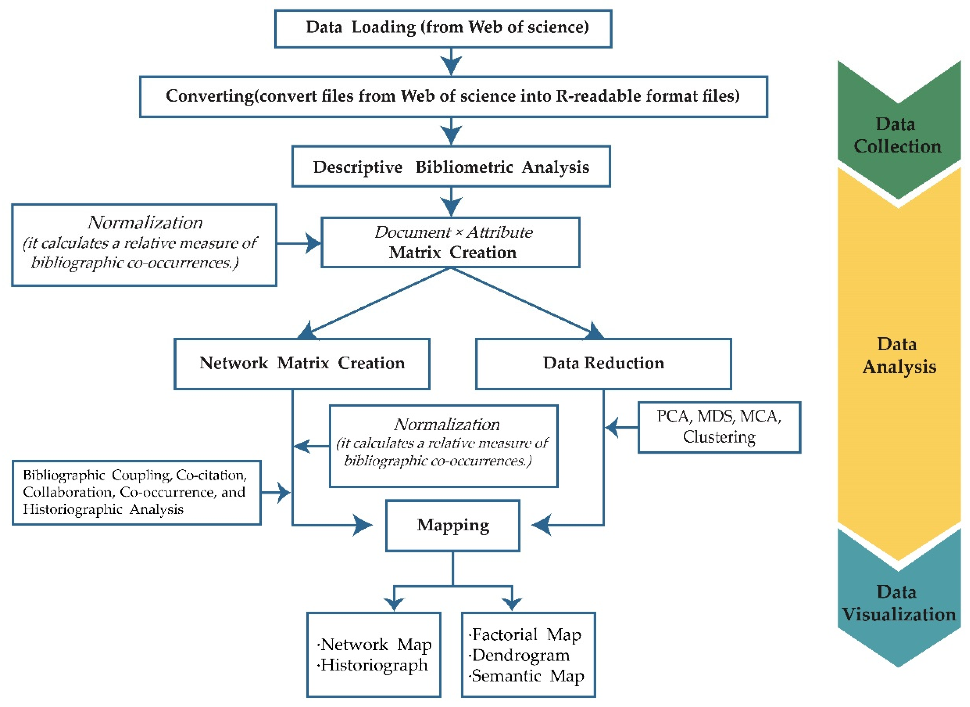
2.2. Research Method

The standard bibliometric analysis process includes five steps: study design, data collection, data analysis, data visualization, and interpretation [34] (As shown in Figure 1). At present, there are some software packages based on R language to measure document information. For example, CITAN can be used to preprocess and clean data from the Scopus database, as well as calculate various bibliometric indicators such as h-index, g-index and l-index. However, it lacks functions such as co-word analysis, coupling analysis, and co-citation analyses [35]. The h-index Calculator can only perform h-index calculation on documents from the Web of Science database [36]. ScientoText lacks a data import and conversion function module [37].
The bibliometrix software package is a bibliometric software package developed by Professor Massimo Aria in 2017 based on R language. It can be used for whole-process bibliometric analysis and visual display. Statistical analysis, data preprocessing, co-occurrence matrix construction, co-citation analysis, coupling analysis, co-word analysis and cluster analysis on documents from the Scopus and Web of Science databases are achievable too. Combing the visualization capabilities of a variety of scientific mapping tools, bibliometrix performs a complete set of literature information analysis and the visualization of results [38].
Based on secondary development of bibliometrix, Massimo Aria developed biblioshiny using an R language shiny software package. The difference between the two packages is that bibliometrix’s operating mode consists of code commands, while biblioshiny uses the shiny package to encapsulate the core code of bibliometrix and create a web-based online data analysis framework. Biblioshiny allows users to perform relevant bibliometric and visual analyses on an interactive web interface, greatly reducing user’s information input intensity and usage threshold. If the user is not qualified for the analysis function developed by biblioshiny, the bibliometrix traditional code would be called to run the program to meet the basic user needs.
The installation and operation steps of bibliometrix and biblioshiny are as follows:
(1) Download and install the latest R language program and RStudio platform. (URL: https://cran.r-project.org/ and http://www.rstudio.com);
(2) Open RStudio and type the following command on the control interface window to complete the installation of the bibliometrix program:
install.packages (“Bibliometrix”);
(3) Type the following command in the control interface window to invoke and open the bibliometrix and biblioshiny programs:
Library (bibliometrix)
biblioshiny
In this paper, the bibliometrix and biblioshiny software packages are used to analyze and visualize the research status and research trends in the field of land degradation. This paper explains the basic laws of land degradation from the aspects of annual documents, research power (country, author, journal), research hotspots, and themes. The analysis on the situation in the field of land degradation research from multiple perspectives (historical citation, subject evolution, and coupling analyses) provides references and suggestions for future land-degradation research.

3. Results Analysis

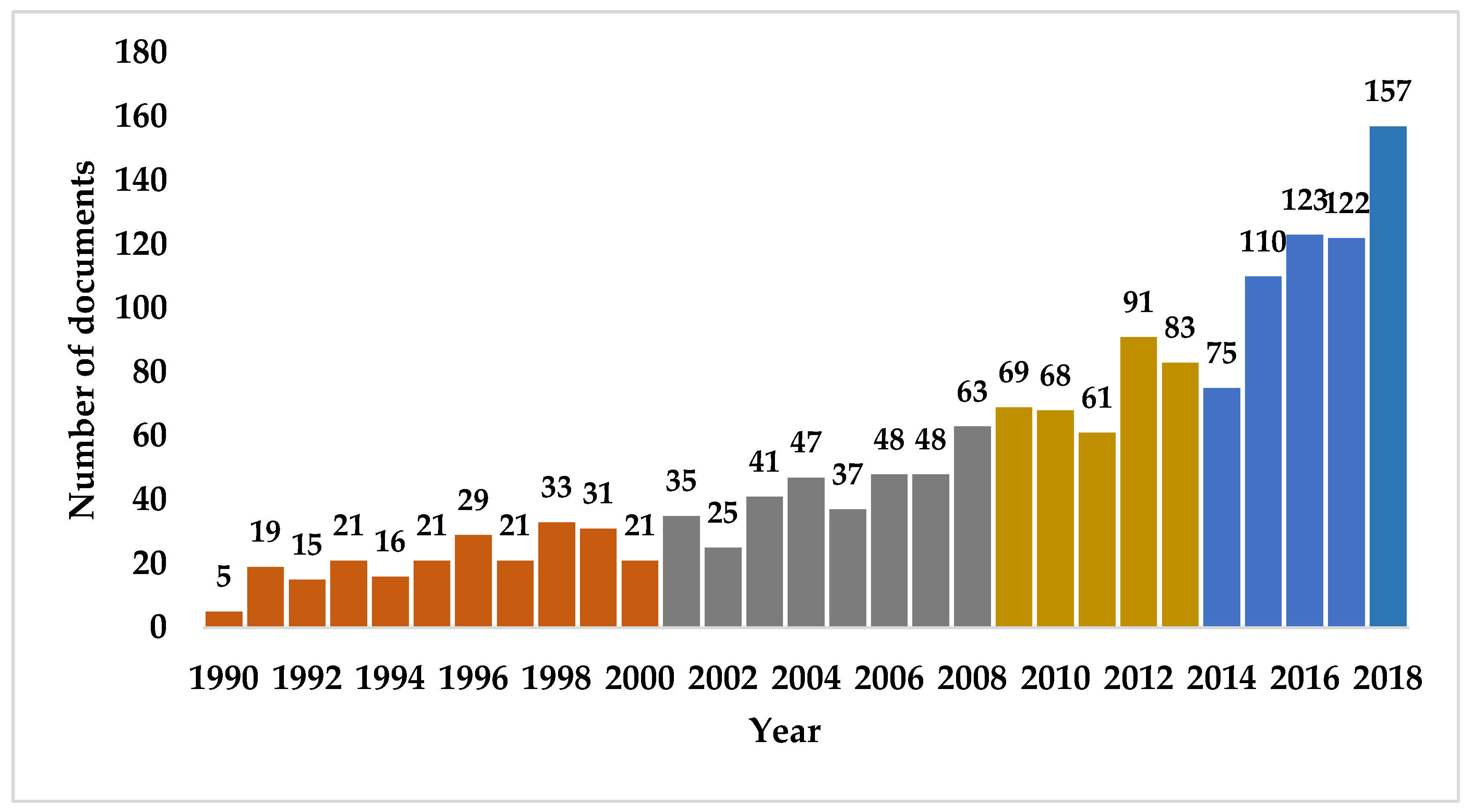
3.1. Distribution of Annual Documents

The development evolution analysis can be tracked year by year in time series, or be divided into different stages. The annual distribution of document number reflects the overall situation and research trends, and the latter shows the overall trend characteristics by describing different development stages. The two methods are combined in this paper.
From 1990 to 2019, despite the slight fluctuations in the number of published research documents on land degradation, the overall trend continued to grow (See Figure 2). The division of the study time zone is generally based on both the literature volume and the fixed time window. At early stages, global environmental resources were relatively abundant, and the disturbance of human life and production activities was weak. The problem of land degradation was not serious, and the ecological environment was better. In this study, the time span of the literature collection is large and the amount of literature regarding the early stage of land degradation is small. Therefore, the combination of literature volume and fixed time window was adopted. Due to the small number of early publications in the field of land degradation, this paper uses 1990–2000, 2001–2008, 2009–2013, and 2014–2019 respectively as first to fourth research time zones. The period 1990–2000 is a low-production exploration period. Before 2000, increase in the published-document number was slow, and the annual average published volume between the years differ slightly. The study on land degradation was in infancy, indicating that the importance of land degradation has not caught most scholars’ attention. During the developmental sprout period of 2001–2007, the document number in this period increased gradually, while the rapid increasing global land-degradation speed had attracted the attention of scholars from various countries. During the expansion of promotion period of 2008–2013, entering a stage of rapid development, the average annual document number was 74. During the high-yield active period of 2014–2019, the document number increased sharply, reaching a maximum of 157 in 2018.

3.2. Analysis of Cited Papers in Land Degradation Research

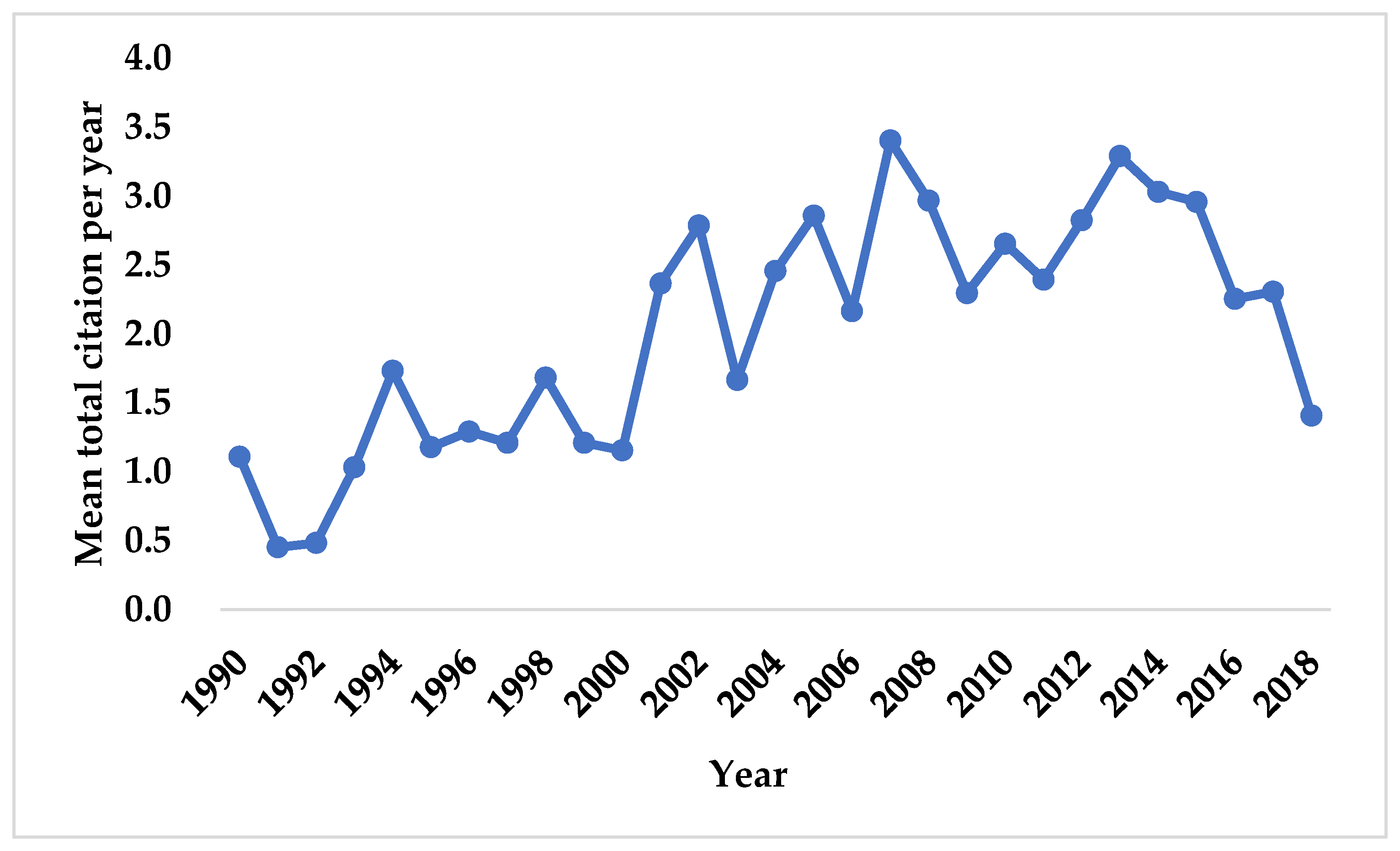
3.2.1. Analysis of the Annual Development Trend of Citations

Figure 3 shows that the average citations per item peaked in around 2002, 2005, 2007, and 2013, and an overall decline can be seen in the second half of 2013. It can be seen from Figure 3 that rather than maintaining the same growth rate, the average citations per item in the field of land degradation experienced several fluctuations. Therefore, in this respect, the average citations per item of papers in the field of land degradation decreased year by year with descending quality or influence. It indicates that land-degradation research has entered a trough period at this stage.
The research period with the highest yield of highly cited papers was between 2001 and 2008, and the highest average citations per item reached 3.40. During 2011–2013, the average citations per item increased rapidly, reaching a peak of 3.29 in 2013. Most of the research during this period focused on trying different models and methods to improve land-degradation monitoring accuracy. For example, Wessels [39] applied linear and non-parametric trend analysis methods, which are based on remote sensing vegetation index to land-degradation monitoring to improve the sensitivity of detection. The research methodology attempts to monitor land degradation under rainfall conditions. Wessels [40] believed that the local net primary productivity (NPP) scaling (LNS) method can effectively map land-degradation areas within a region.

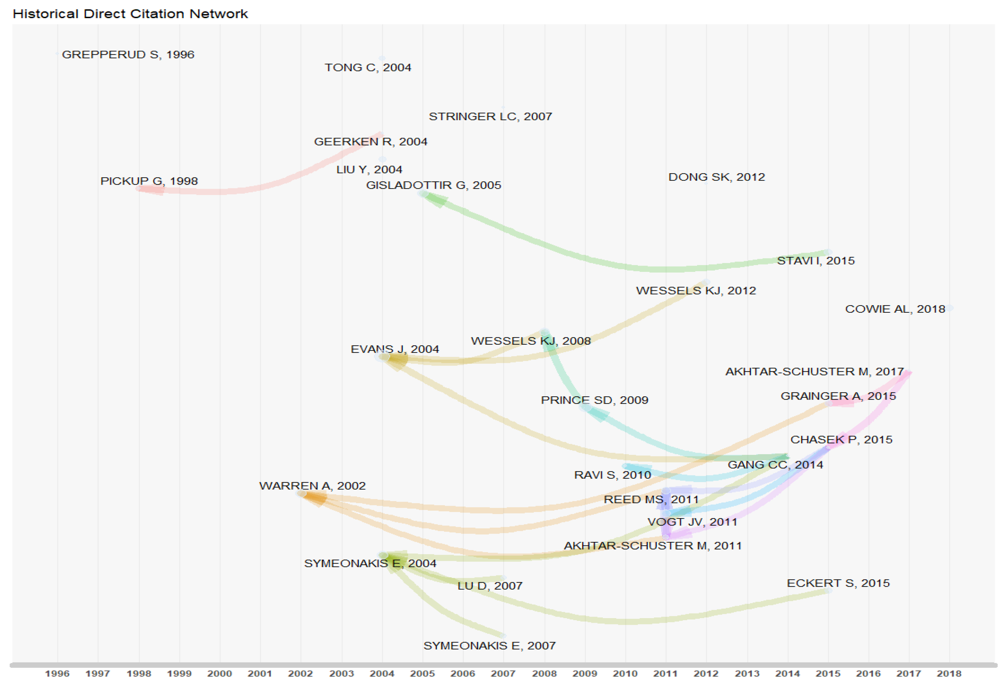
3.2.2. Historical Analysis of Citied Papers of Land-Degradation Research

The hisNetwork and histPlot functions in the bibliometrix package were used to generate a historical direct citation network and visually analyze the network. The raw data was analyzed by LCS (local citation score) and GCS (global citation score) indicators. LCS refers to the number of citations of papers in the local data set (This refers to the 1572 articles obtained from the Web of science in this paper). The higher the LCS, the more important the paper is in the field of land degradation. GCS refers to the total number of citations of papers in the Web of Science database, but the cited papers are not necessarily those in the field of land degradation. Each node in the Figure 4 represents a key document, and the directional arrow indicates the citation relationship between the two documents.
As can be seen from Figure 4, the document nodes between 1990 and 1995 are blank, indicating that there is no highly cited classical literature during this period. The earliest node was the paper Population Pressure and Land Degradation: The Case of Ethiopia published in Journal of Environmental Economics and Management. In this paper, taking the Ethiopia region as research area, a threshold model was used to empirically study the threshold effect of human and animal growth on the severity of soil erosion index. The empirical results show that when human and animal pressure is greater than the threshold, the land would be rapidly degraded.
A number of classic documents emerged between 2001 and 2008 (see Figure 4). Among them, the paper with the highest LCS and GCS values is the paper Discrimination Between Climate and Human-Induced Dryland Degradation published by Evans in Journal of Arid Environments in 2004 [41]. The LCS and GCS values are 31 and 248 times, respectively (see Table 1 and Table 2). Based on the evaluation of AVHRR (The AVHRR is a four- or five-channel visible–thermal IR radiometer with a nadir resolution of 1.1 km which stretches out to about 6 km at the edge of scan.) NDVI (The NDVI is a dimensionless index that describes the difference between visible and near-infrared reflectance of vegetation cover and can be used to estimate the density of green on an area of land.) data and rainfall data, Evans proposed a method to distinguish the different effects of climate and human activities on dryland degradation. The results show that arid areas are prone to land degradation under the influence of climate change and human activities. It is also suggested that human activities such as planting edible shrub species are the main driving forces of land degradation in arid areas. Tong [42] published a paper in Journal of Arid Environments in 2004 with a high GCS but low LCS. It indicates that this concern is mainly from scholars who are not in the field of land degradation. This paper may not be very meaningful in this field.
The paper Land Degradation Is Contextual, published by Warrena in Land Degradation & Development in 2002, triggered three distinct citation chains [8]. There is a clear citation relationship between the three citation chains. Warrena believed that land-degradation assessment should be combined with the spatial, temporal, economic, environmental, and cultural background of the study area for dynamic analysis. Moreover, the study found that large-scale land-degradation assessment may meet difficulties such as large data volume and complicated calculation, so it is difficult to monitor the land-degradation process at provincial and national scales.
The paper Monitoring Desertification and Land Degradation over Sub-Saharan Africa, published by Symeonakis in International Journal of Remote Sensing in 2004, triggered four distinct citation chains [44]. Using large-scale remote sensing data, Symeonakis developed a desertification monitoring system to derive four indicators of land degradation (vegetation cover, rain use efficiency (RUE), surface run-off, and soil erosion) and monitor sensitive areas of land degradation. Symeonakis self-cited this article in 2007. Based on two important land-degradation indicators (surface runoff and sensitivity of soil erosion), taking Xaló Rive as the research area, Symeonakis [48] analyzed the impact of land-use dynamics on land degradation. The study results indicate that land degradation is mainly affected by agricultural land abandonment, forest fires, and tourism development, and identifies potential areas of land degradation. In general, Scholar Symeonakis’ research in the field of land degradation is continuous, coherent, and stable.
With stronger citation relationships, the key node literature between 2009 and 2019 began to increase in volume, indicating very active research in the field of land degradation during this study period. Besides, the three documents published in 2011 are frequently mutually cited. Chasek’s paper Operationalizing Zero Net Land Degradation: The Next Stage in International Efforts to Combat Desertification? published in the Journal of Arid Environment in 2015, simultaneously cited three important documents in 2011, and belonged to multiple citation chains, which were key nodes of this study period [51]. Chasek explained the global state of land degradation, its impact on land productivity, and the threat of food security from a macro perspective. In this context, the serious challenges of implementing Zero Net Land Degradation are discussed, including scoping (selecting a land-degradation neutral range), mapping (classifying land by land use, management characteristics, utilization methods, and production status), prescribing (developing corresponding land-management policies for different land types), applying the selected land management (improving the ability to withstand land degradation). Finally, adjusting the policy according to implementation effect.

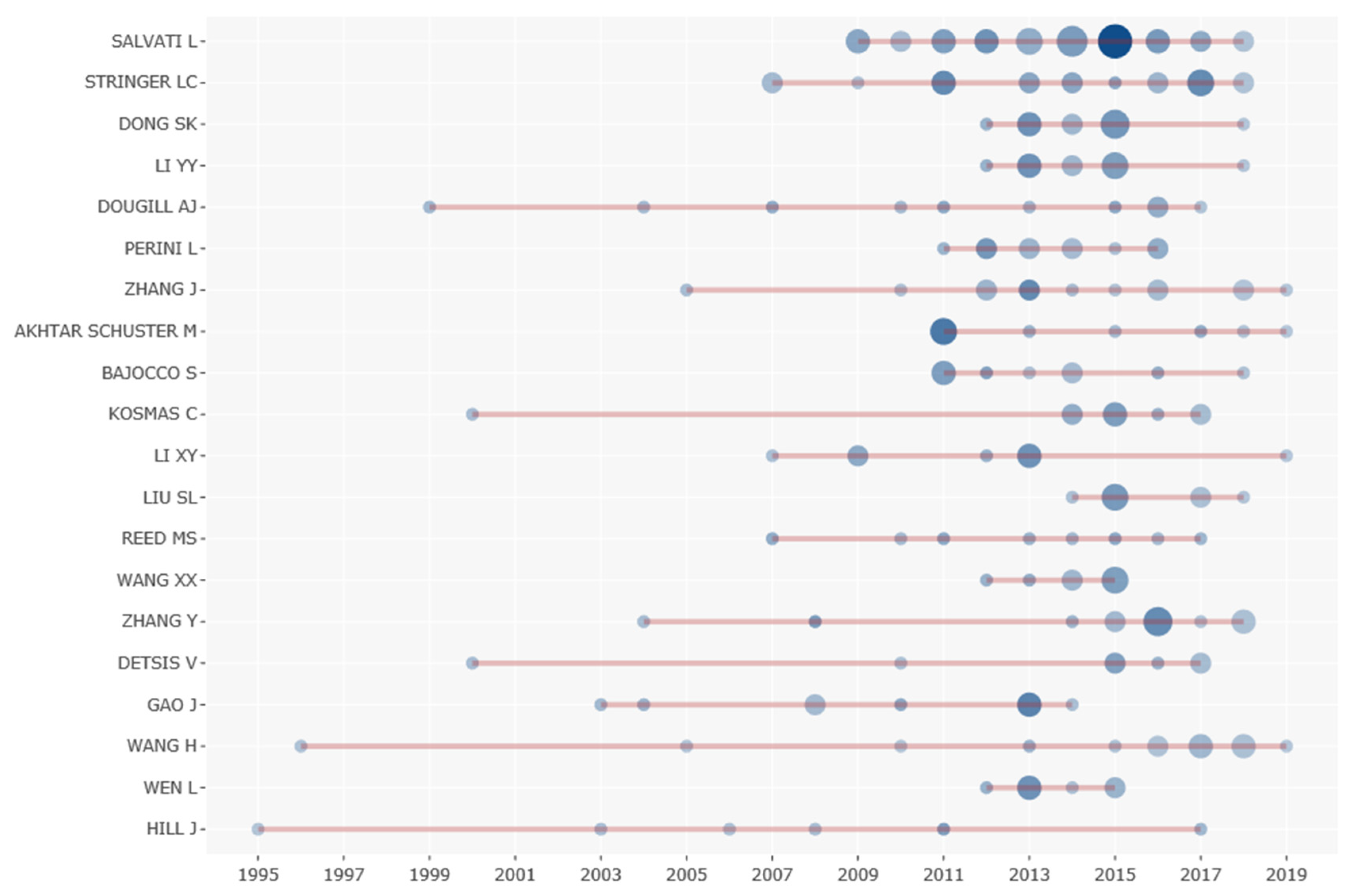
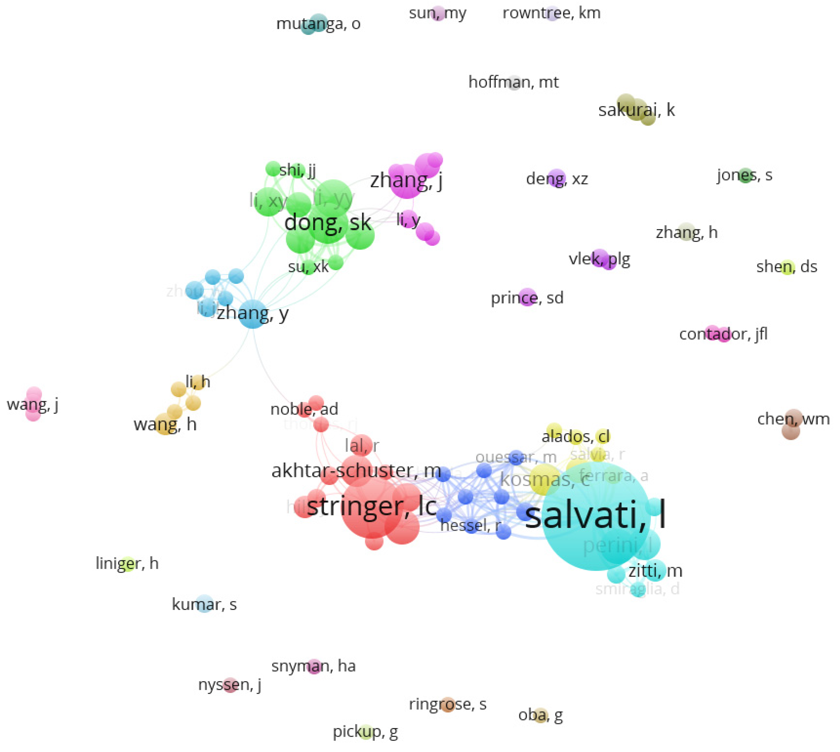
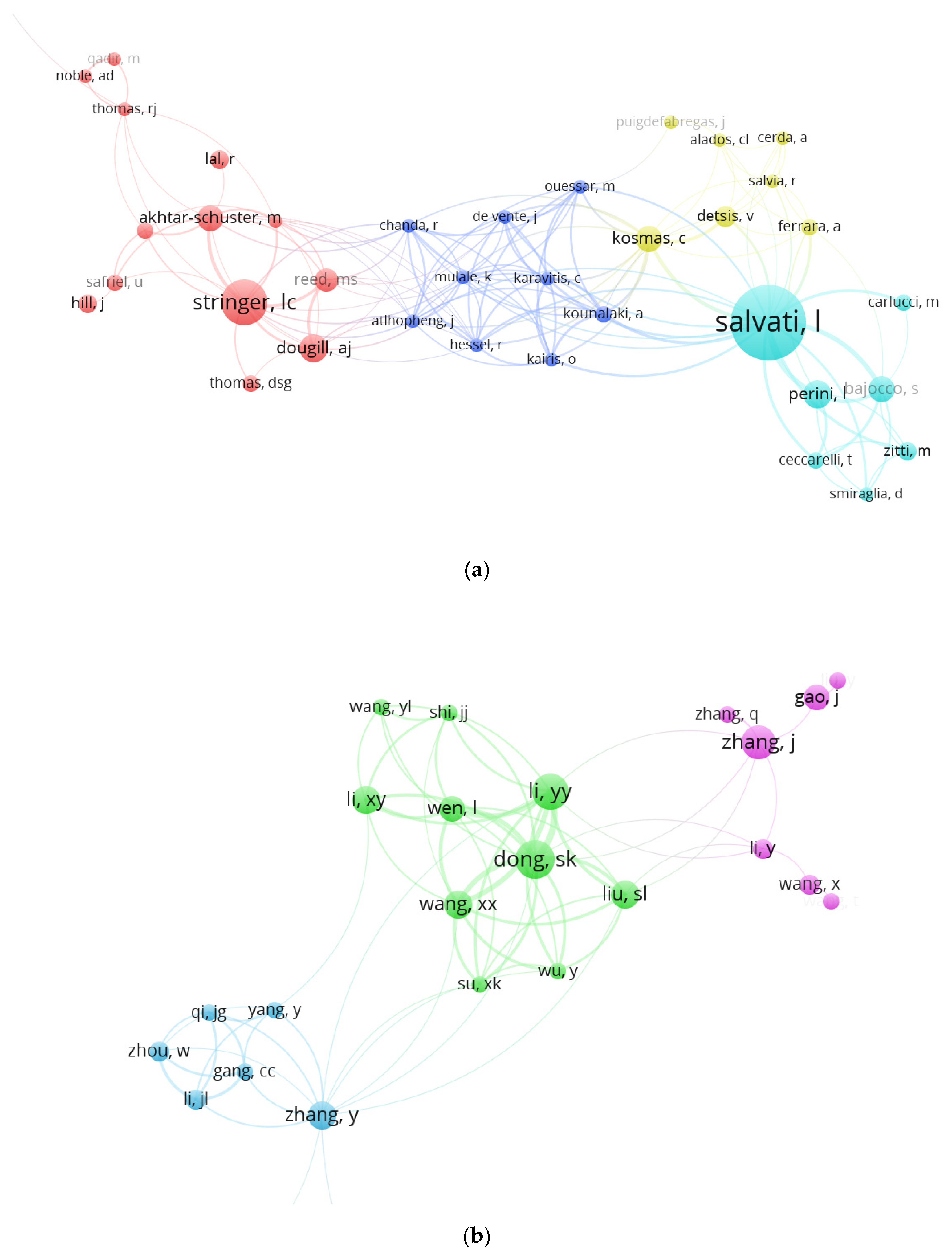
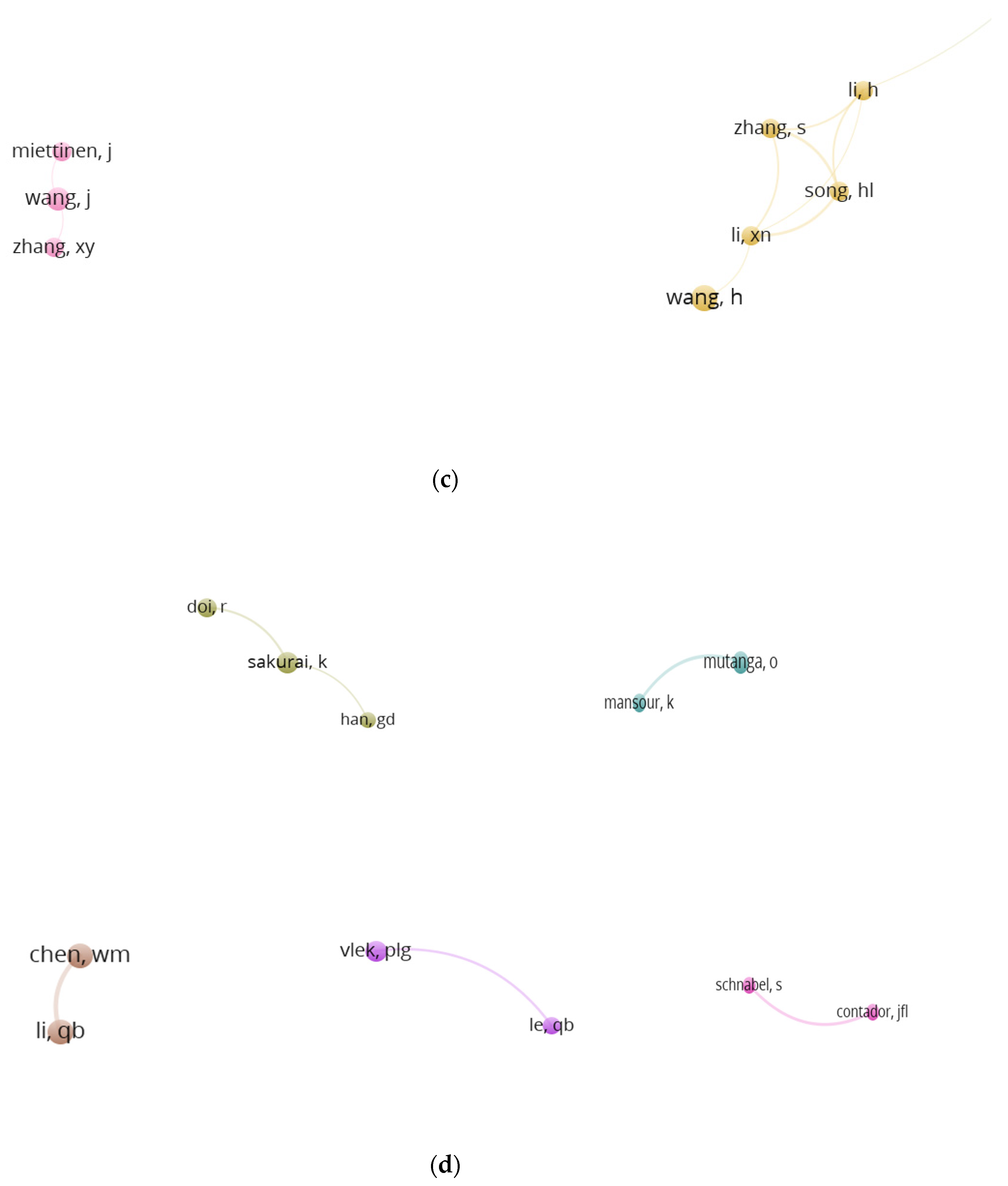
3.3. Analysis of Main Researcher

The research paper involved 5316 authors in total, among which 4591 authors have 1 paper, 631 authors have 2–3 papers, 79 authors have 4–7 papers, and 14 authors have 8–9 papers. From the perspective of issued paper numbers (Table 3), the top four authors are Salvati L, Stringer LC, Dong SK, and Li YY, with 36 articles, 19 articles, 12 articles, and 11 articles, respectively. In the field of land degradation, the Greek scholar Salvati L ranked first in document number. Salvati L’s h-index, g-index, and total citation values are 15, 23, and 597, respectively. With a large number of published high-quality papers, Salvati L is influential in the field of land degradation. As can be seen from Figure 5 (the size of the circle in the figure represents the number of documents, and the shade of the color represents the amount of citations.), Salvati L has started to publish papers since 2009, with the largest number of published documents and the highest frequency of average citations per item in 2015. For example, Salvati L’s paper Community Resilience and Land Degradation in Forest and Shrubland Socio-Ecological Systems: Evidence from Gorgoglione, Basilicata, Italy published in the Land Use Policy journal in 2015 was cited 57 times [52]. Based on quantitative data at spatial and temporal scales, the article uses a hybrid model to study the complex interrelationships between community resilience, forest ecosystems, and land degradation in Gorgoglione. The results show that the low price of agricultural and forestry products has a negative impact on farmers’ livelihoods, resulting in agricultural practitioners’ migration, farm fragmentation, further deteriorating land abandonment.
Salvati L’s research in the field of land degradation focuses on ecosystem productivity maintenance, land resource management, and sustainable development. For example, Salvati L’s paper published in Sustainability in 2018 shows that the reason for landscape fragmentation in the Mediterranean region was related to residents’ long-term unreasonable social and economic activities [53].
The command vos.path = ””, type = ”Vosviewer”, size = T, remove. multiple = T was used to call the Vosviewer software to generate a collaboration map of authors to reflect the scientific research cooperation between them (see Figure 6). Many author cooperative sub-networks (see Appendix B) are generated in the author collaboration map, and the sub-networks centered on SALVATI L form a relatively complex relationship. It shows that in the field of land-degradation research, scholars have formed an academic pattern of close contact and mutual cooperation. A total of 14 sub-networks are formed in this paper. The existence of sub-networks increases the complexity of the network structure to a certain extent. The social network is not only a relational link network between nodes, but also because different nodes may form sub-networks, a new network structure is formed between the sub-networks. The more types and numbers of subnetworks, the more complicated the network structure. Each network is centered on Stringer LC, Karavitis C, Salvati L, Kosmas C (see Figure A1a), Zhang Y, Dong SK, Zhang J (see Figure A1b), Wang J, Song HL (see Figure A1c), Sakurai K (see Figure A1d). The sub-network represented by Stringer LC has a high clustering density, and the author has a great influence in the field of land degradation. Stringer LC began her research in the field of land degradation in 2007 and had a high volume of literature output in 2010 and 2017. Scholar Stringer LC’s citation frequency, h-index, and g-index values are 362, 12, and 19 respectively. Stringer LC’s research themes in the field of land-degradation research mainly include remote sensing monitoring, land-degradation assessment, and its ecological effects [54]. Corn in Swaziland’s middleveld area is threatened by Straga asiatica weeds. Striga asiatica weeds parasitize on corn crop, providing nutrients and moisture content for themselves, but reducing the yield of the corn crop. In view of this, Stringer [55] explored the impact of corn crop production decline (a land-degradation biological indicator) on farmers’ livelihoods, and investigated farmers and policy makers’ measures to deal with Straga asiatica weeds. The results show that farmers’ ability to deal with weed pests is affected by environmental, social, and political factors, and the government’s policy of dealing with land degradation is often ineffective. Therefore, the government should increase farmers’ human capital, deepen farmers’ understanding of Striga asiatica weeds, and strengthen farmers’ weeding technology. The government should list Striga asiatica weeds as an important indicator of land degradation and increase attention to Striga asiatica. The density of the entire cooperation network is very low. A few scholars have a certain degree of cooperation, but most scholars lack cooperation, and the research cooperation network diagram is relatively scattered.

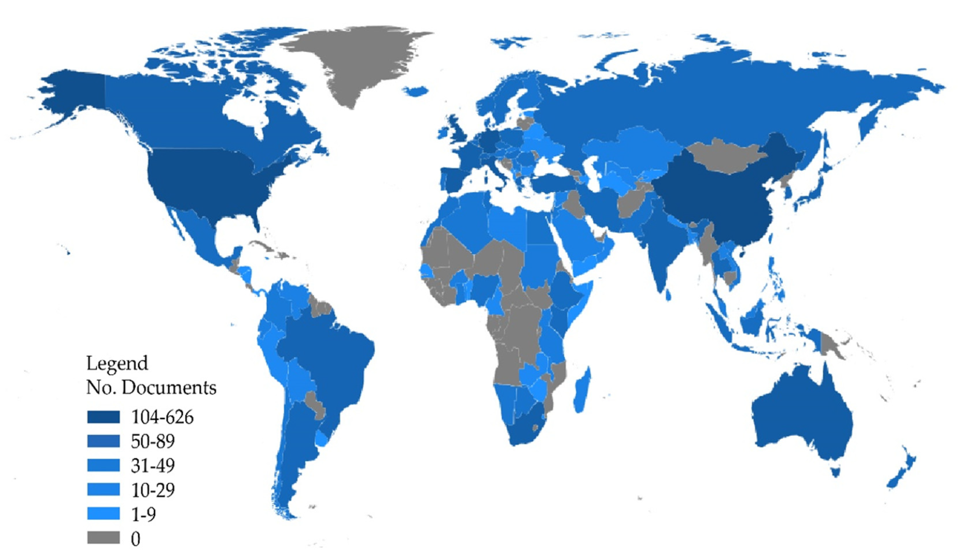
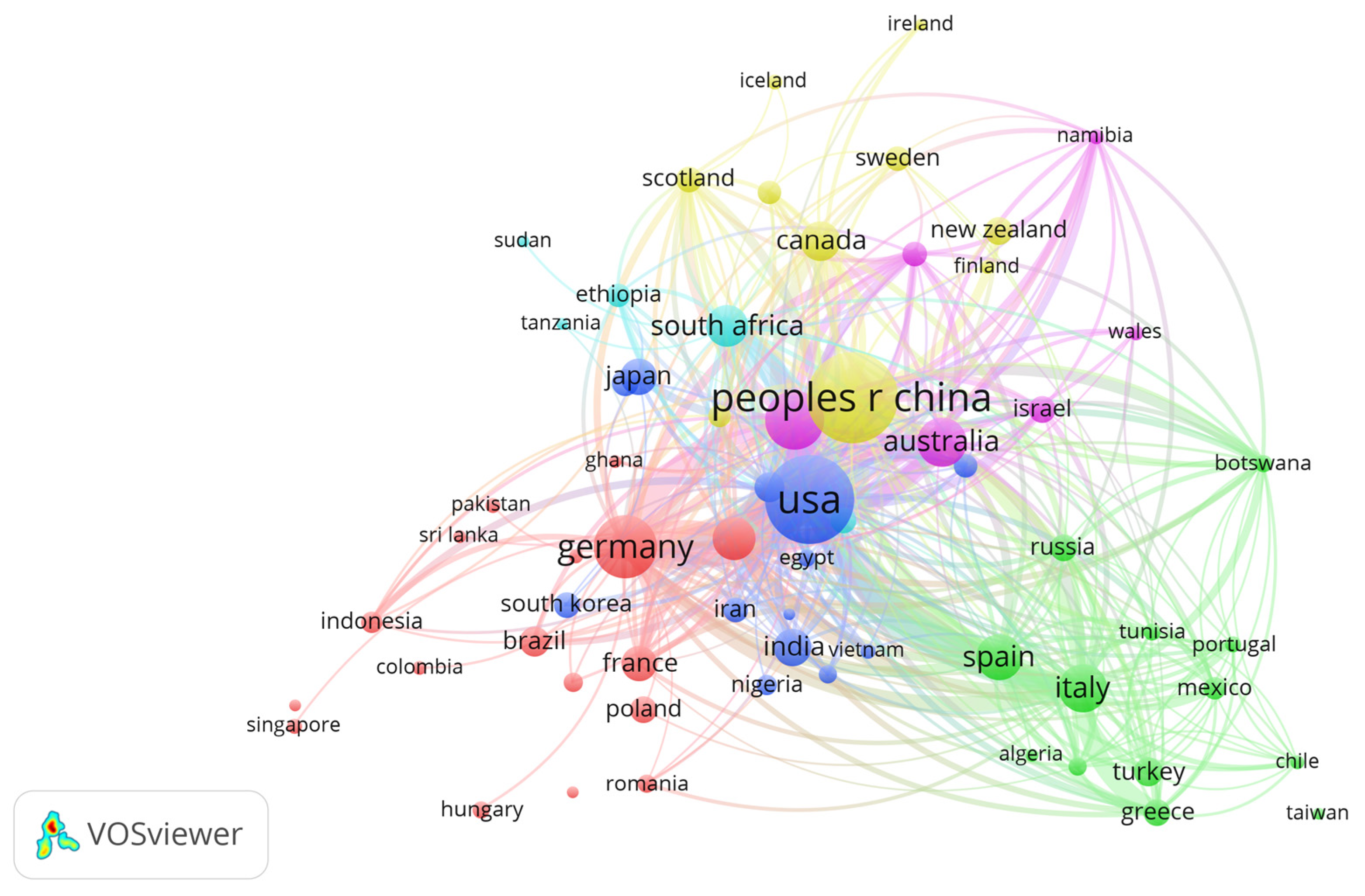
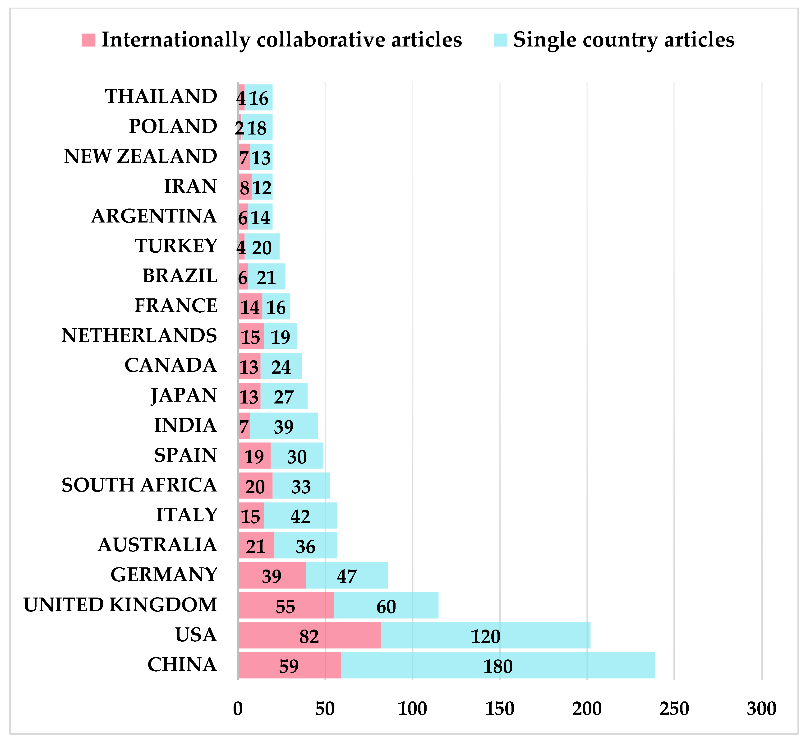
3.4. Analysis of Distribution Characteristics of Major Research Countries/Regions

The publication of papers in different countries can reflect the importance and influence of the country in the field of land degradation to some extent. A total of 93 countries or regions published papers between 1990 and 2019. As can be seen from Table A1 (see Appendix A) and Figure 7, among the top 20 countries, there are six Asian countries (China, India, Japan, Turkey, Iran, Thailand), four American countries (USA, Canada, Brazil, Argentina), seven European countries (UK, Germany, Italy, Spain, Netherlands, France, Poland), two Oceania countries (Australia, New Zealand) and one African country (South Africa). The top five countries with the highest number of documents in descending sequence are China, the United States, the United Kingdom, Germany, and Australia. Figure 7 shows that paper publications are mainly concentrated in developed countries such as Europe and North America, indicating that developed countries play a leading role in the field of land-degradation research. Theoretically, the study of land degradation has a greater impact on agricultural countries and developing countries, but in view of academic research, developed countries occupy more seats. This is related to many factors. Among them, the relatively low level of science and technology and the fund shortage lead to the insufficient investment in some agricultural-based regions, being unable to support more academic research. Moreover, the lack of technology, capital, and talent pools in many developing countries make it difficult to occupy a large number of seats in the world.
China is the only developing country listing among the top five countries in document number. The document number in China has far exceeded those of other countries, accounting for 15% of the 93 countries. The document number is relatively high. The reason may relate to China’s long history and rich traditional knowledge in agriculture. However, the average citations per item is only 12.86, indicating that despite the high document number in the field of land degradation in China, the article level needs to be further improved. The land-degradation types in China mainly include soil erosion, land desertification, land salinization, land depletion, land pollution, and land damage. Chinese scholars are committed to build a policy guarantee system for the restoration and reconstruction of the ecological environment of degraded land. For example, based on multi-year remote sensing data and other relevant data from 54 counties in China’s Mongolian pastoral areas from 2001 to 2004, using remote sensing and fixed effects models, Liu [56] analyzed the impact of the Subsidy and Incentive System for Grassland Conservation (SISGC) on grassland restoration. The paper found that empirical studies quantitatively proved that SISGC helped improve grassland conditions, but the effectiveness of SISGC was constrained by other social and climatic factors. Besides, rising producer price and high temperatures are also important factors that exacerbate grassland degradation. The Loess Plateau is one of the most ecologically fragile areas in China. The fragile phenomenon of the ecological environment on Loess Plateau are severely worsened, and disasters such as soil erosion, desertification, drought, and sandstorms occur frequently. Taking the Zhongzhuang small watershed in Pengyang County, Ningxia Hui Autonomous Region, China as the research area, Wang [57] analyzed the diversification characteristics of farmers’ livelihoods and their impact on the local environment. The results showed that maintaining farmers’ livelihood diversification had a significantly positive impact on ecological landscapes restoration. Therefore, the government should maintain or improve farmers’ livelihood diversification level by providing technical training for local farmers, establishing a mature agricultural trade market, and stimulating the rural financial system.
In the United States, both the total number of citations and documents are high. With a total number of 6908, the citations ranked first. The United States is the country with the strongest growth momentum. With a value of 34.78, Canada is the country with the highest number of average citation per item, but its document number only ranked 11th. It shows that although the document number is small, the article level is relatively high. Canada is the first country combating desertification, and it becomes one of the best examples in global land-degradation prevention. The government department has established a special land resource management agency and coordination mechanism to formulate comprehensive management and protection policies for easily degraded land such as forest land, agricultural land, and mining land. An empirical evaluation on policy content, policy implementation, and policy effects is carried out and good results are achieved. For example, when assessing the impact of agricultural policies in Western Canada on land degradation, Lakshminarayan [58] developed a new method which integrated economic and environmental factors by applying metamodels. Using farm net income, total economy, surplus (consumer plus producer surplus), and total regional soil loss, Lakshminarayan assessed the trade-off relationship between land-degradation status and no-till policy. The results show that under the no-till policy, society will present an obvious win–win situation.
The command vos.path = ””, type = ”Vosviewer”, size = T, remove. multiple = T was used to call the Vosviewer software to generate a collaboration map of countries. Each node represents a country. There are connecting lines between the nodes, indicating that there is a cooperative relationship between the countries [59]. The thicker the link between countries, the stronger the collaborative relationship, and vice versa (See Figure 8). Figure 8 shows that the United States has outstanding performance in international collaboration. The number of papers with international collaboration is 82. Among them, frequent collaborations are made by China, Britain, Australia, and Italy, with collaboration frequency of 42, 20, 15 and 11 times, respectively. China has the largest document number in the field of land degradation, but most are independent research and it only collaborates with New Zealand, South Korea, Japan, Thailand, and Australia. Located at the edge of the collaborative network, China’s independent papers account for 75.3% of all China’s papers (see Figure 9), which can be traced from the collaboration data of representative countries in the field of land degradation (see Table A1). In addition to the United States, the United Kingdom, Germany, the Netherlands, and other countries with international collaboration, the rest countries mainly focus on independent research. The number of papers with domestic collaboration is greater than that with international collaboration.

3.5. Analysis of Keywords

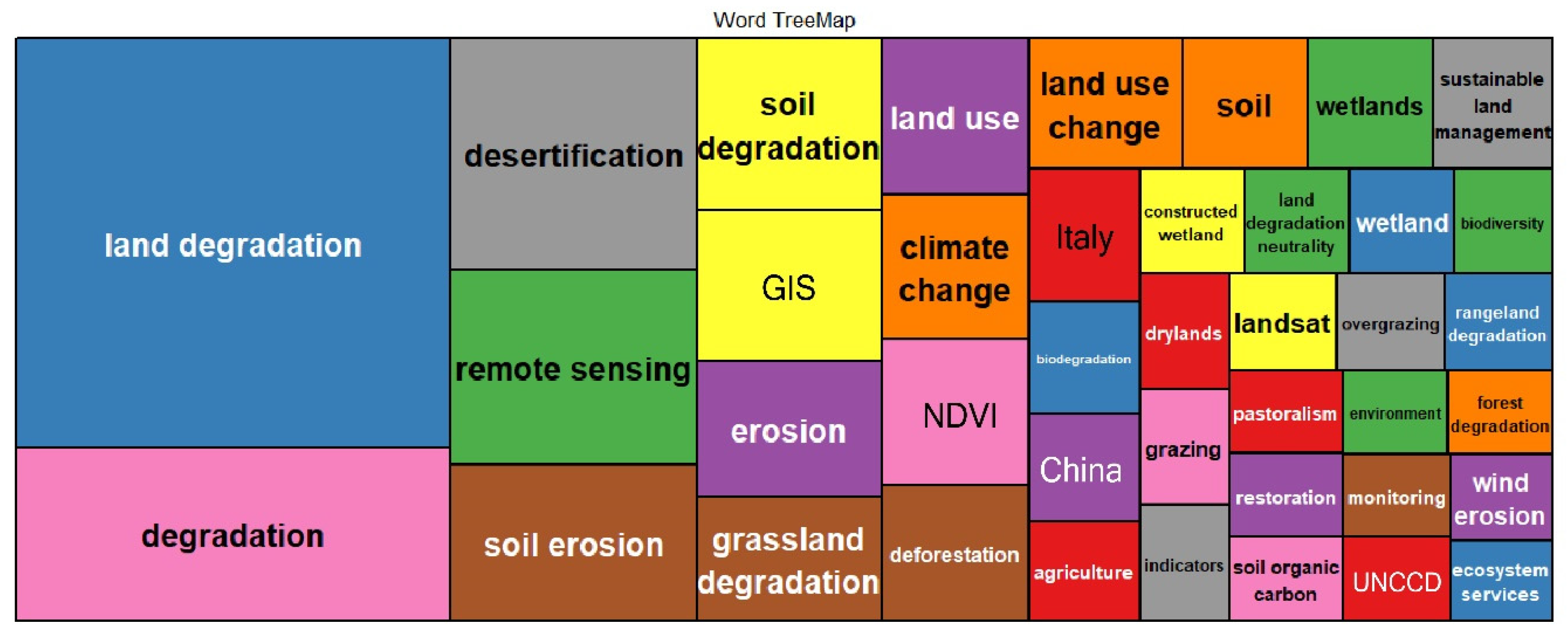
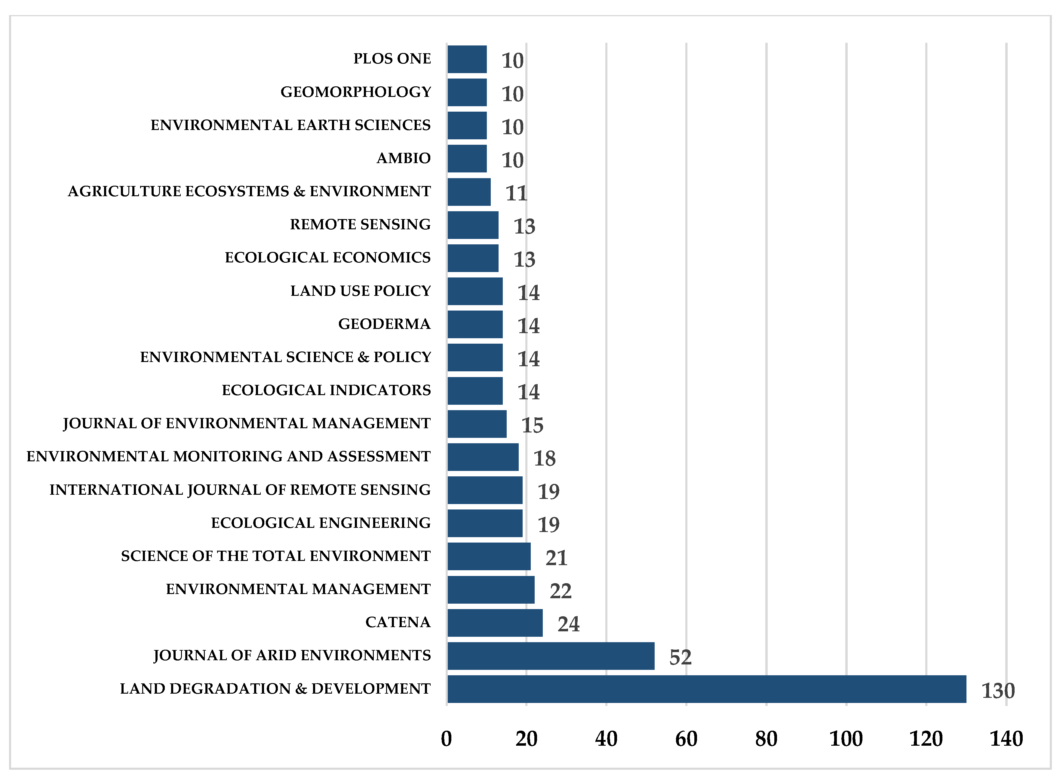
3.5.1. Analysis of High-Frequency Keywords

The keywords are the high-level summarization and refinement of the article core. The analysis of key words such as cluster analysis and multiple correspondence analysis in the article reflects the theme and writing direction of the article in the field of land degradation in a concise and intuitive way. Data mining and statistical analysis of the high-frequency keywords of the research papers are carried out by the software package biblioshiny. Using the software package biblioshiny to conduct data mining and statistical analysis on the high-frequency keywords of the research papers, keywords with word frequency greater than or equal to 10 are selected and drawn as a Word TreeMap (see Figure 10). Figure 10 shows that the most frequently appeared keywords involved in the field of land degradation are land degradation, degradation, desertification, remote sensing, soil erosion, and soil degradation, accounting for 17.7%, 0.08%, 0.05%, 0.04%, and 0.03% respectively (see Table A2). It shows that the field of land degradation has been extensively studied in soil, remote sensing and desertification. Desertification refers to land degradation in arid, semi-arid, and sub-humid areas caused by a variety of factors, including climate change and human activities. It is a comprehensive and multifactorial process related to ecology, geography, climate, and humanities, etc. As one of the most serious environmental problems, desertification has caused a wide concern among scholars for its causes, classification, assessment, and prevention [60]. Darkoh [61] believed that the institutional obstacle of combating desertification is that African governments have not yet tried to decentralize to those affected by desertification. Facing government’s demand for economic growth, the formulated trade policies often conflict with agricultural policies. Therefore, Darkoh proposed that African governments need to place people’s welfare at the center of the development agenda and give them the power to decide their future development. Besides which, developed countries should help African countries to reduce poverty and environmental pressures.
The scientific nature of monitoring and evaluation is directly related to the distribution of desertification, the assessment of hazard levels, the development of monitoring standards, and the evaluation of prevention measures and effects. Therefore, to combat desertification, reasonable monitoring and evaluation are essential. The development of desertification prevention policy requires accurate monitoring and evaluation indicators [62]. For example, Löw [63] listed seven Kuwaiti land-degradation indicators (wind erosion, water erosion, reduced vegetation coverage, soil compaction, oil pollution, and soil salinization). Based on this, he evaluated the extent and degree of land degradation in four regions of Kuwait. The indicators of four aspects, such as remote sensing image and vegetation coverage, were investigated. Finally, land degradation was divided into three levels: heavy, medium, and light. Sepehr [64] applied the TOPSIS measurement method to the desertification rating index research, and five of 29 indicators were used for land-degradation evaluation through experiments. These five indicators are: increased vegetation cover, changes in land use patterns, forest fires, canopy closure or biomass reduction, and increased arable land area. It is also proposed that these five indicators are key indicators for land-degradation assessment in Brazil, Mozambique, and Portugal.
Grassland, rangeland, and forest are the main land types of land degradation. Among them, grassland degradation is the most frequent, as grassland ecosystems are more sensitive to changes in temperature, precipitation, and soil moisture than other ecosystems [65]. In recent years, under the influence of unfavorable natural factors such as drought, sandstorm, water erosion, salinity, internal helium, groundwater level change, or unreasonable human activities such as overgrazing, over-excavation, indiscriminate cutting and slashing, the grassland utilization performance declined and the grassland ecosystem continued to degenerate [66]. Therefore, the dynamic monitoring and prevention of grassland degradation are the main work content of regional ecological environment protection. For example, Akiyama [67] compared and summarized the technical means, basis, and classification status of common grassland-degradation assessment and monitoring methods. Akiyama proposed that the future development trend of grassland-degradation monitoring was the measurement based on spectral emissivity and the combination of remote sensing and GIS.
Among the various factors affecting land degradation, soil erosion is the most common and important factor. In 1971, the United Nations Food and Agriculture Organization listed soil erosion and its siltation process as the first item of the first category in the “World’s Land Degradation Priorities Recommendation”. Water erosion accounts for 56% and wind erosion accounts for 28% of global soil degradation. Posing a threat to agricultural production, water quality, hydrology, and other systems, increasingly serious soil erosion is a challenging problem restricting mankind’s sustainable development [68]. The form and intensity of soil erosion are temporally and spatially different. Therefore, the dynamic monitoring of soil erosion intensity is of great significance for the prevention and control of soil erosion [15,69]. The use of modelling is a commonly used method for the quantitative measurement of soil erosion. However, due to the large number of parameters required by physical and distributed modelling of the soil erosion process and the limited practicality, the USLE/RUSLE model is the most widely used [70].

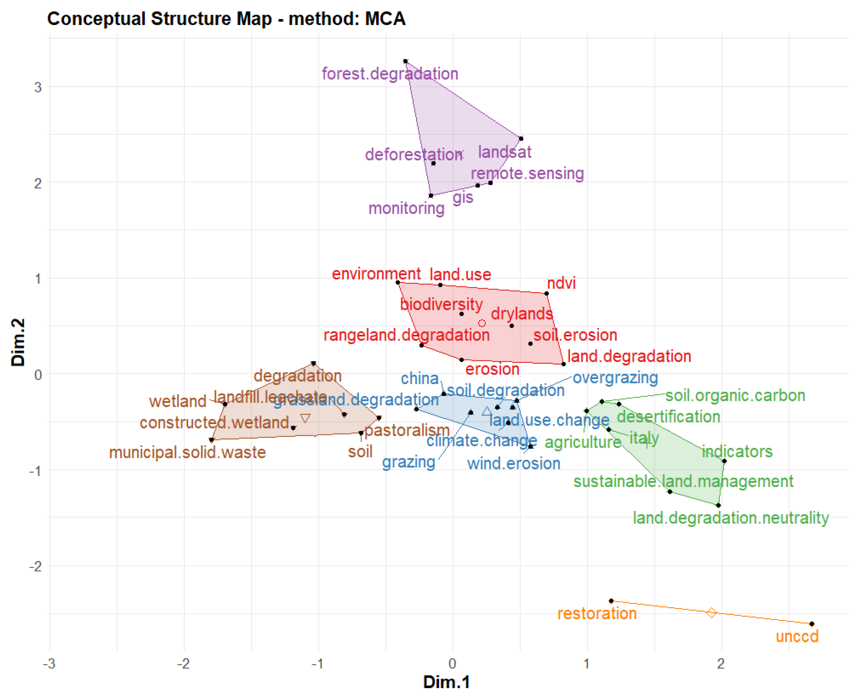
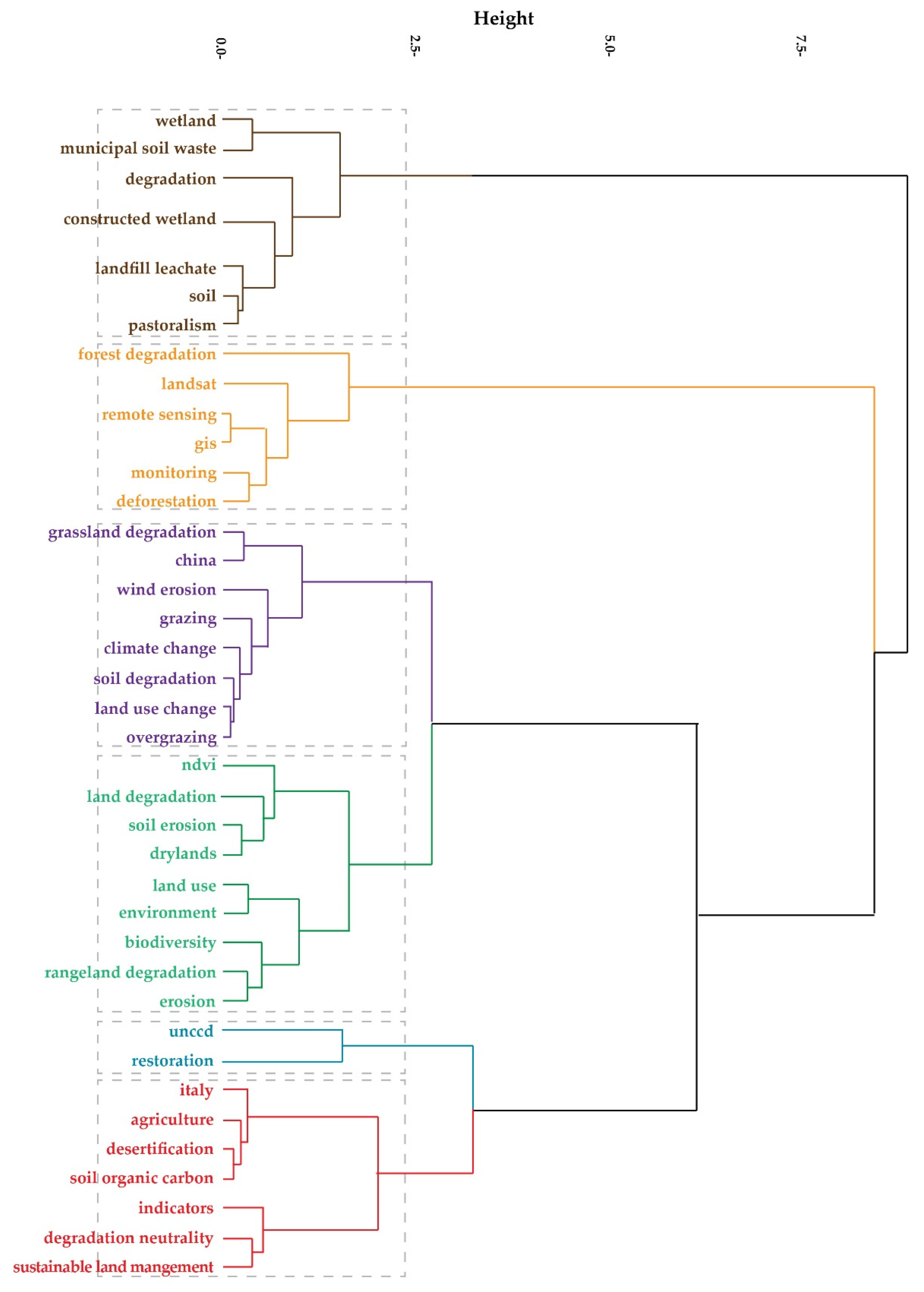
3.5.2. Cluster Analysis and Multiple Correspondence Analysis of High-Frequency Keywords

Cluster analysis in bibliometrics is based on the frequency of simultaneous occurrence of two keywords, using statistical methods to simplify the complex keyword network relationship into several relatively small groups [71]. The hierarchical clustering method is used in this paper. Firstly, we treat each clustered keyword as a class, and then combined the two clusters with the highest degree of similarity to form a new large cluster. Then the new cluster is merged with the cluster with the highest degree of similarity. The merge is repeated in this way until all individuals are grouped together. Finally, the entire classification system forms a tree dendrogram, showing the close or alienated relationship between the keywords in the field of land degradation. Multiple correspondence analysis (MCA) is a commonly used sociological approach. It compresses large data with multiple variables into a low-dimensional space to form an intuitive two-dimensional (or three-dimensional) graph that uses plane distance to reflect the similarity between the keywords. Keywords approaching the center point indicate that they have received high attention in recent years. The nearer to the edge, the narrower the study theme, or the transition to other themes (See Figure 11) [72]. Combining with Figure 11 and Figure 12, the land-degradation research field can be summarized as follows:
(1) The first major category of cluster analysis is mainly involved with research in wetland degradation. In the case of large natural wetland loss, many research directions have been rapidly formed, including wetland-degradation processes and mechanisms, degradation assessment, degradation grading, degradation indicator systems, degraded wetland management, remote sensing monitoring of degraded wetlands, degraded wetland restoration and reconstruction, etc. [73,74,75]. The research area centers on the world’s important wetlands such as the Florida Everglades, Rhine River, Lake Victoria, and Pantanal. Among them, the wetland-degradation process and mechanism research in Florida Everglades is the most in-depth. For example, taking the Florida Everglades as the research area, Richardson [76] found that phosphorus pollution from agricultural fertilization is the key stress factor for the degradation of the Everglades, and determined its intensity threshold. The research history on the ecological restoration of degraded wetlands is short. At present, the restoration technology mainly focuses on degraded wetland vegetation restoration technology, degraded wetland soil restoration technology, and degraded wetland hydrological recovery technology. For example, Lake [77] believed that it is important to understand the life history and habitat type of vegetation, and restore vegetation shelters with regard to vegetation restoration. This is of great importance for the survival and recovery of the original vegetation population after catastrophic disturbance. Through the study of soil recovery process of peat swamp wetland, Niedermeier [78] found that due to redox, the traditional practice of restoring soil fertility through flood alluvial, would cause soil nutrient loss and increase water pollution risk. Therefore, in the process of wetland soil restoration, it is necessary to conduct an in-depth research on the various biological, physical, and chemical processes to formulate a reasonable plan.
(2) The second major category of cluster analysis is mainly concerned with the monitoring of dynamic changes of forest degradation (deforestation) based on remote sensing and GIS. In recent decades, global problems such as rapid population growth, socio-economic development, and high-intensity development and utilization of forest resources frequently appeared. The difficulty in forest ecosystem recovery and the reverse succession changes in the opposite direction lead to forest degradation directly or indirectly [79,80]. Forestland-degradation monitoring research, providing a scientific basis for scientific afforestation and rational development and utilization of regional forest land resources, helps fully excavate the potential of forest land production, achieve the balance of forest ecosystems, improve regional ecological environment, scientifically formulate forest management plans, realize the sustainable development of forestry management, etc. [81]. For example, Lambin [82] argued that forest degradation had certain ecological reversibility, and climate change had a significant impact on forest degradation monitoring. He also suggested dividing land cover into several continuous areas representing by biophysical variables to accurately monitor forest degradation. Therefore, it is necessary to repeatedly measure the spectral characteristics at the surface of these areas and the associated spatial and temporal indicators. Lambin [82] proposed that different monitoring systems have different effects on different ecosystems. Therefore, future research needs to accumulate case study examples to determine which method and which combination of information sources are most suitable for which ecosystem.
On the other hand, although economic globalization can promote the development of the country’s economic development, it also has a significant negative impact on the ecological environment. However, environmental policy can alleviate the contradiction between economic development and environmental protection to a certain extent. For example, Wang used Laos as a research area to explore the response characteristics of inland developing countries to economic globalization. The results show that since 2000–2017, the conversion rate of plantations and natural forests is as high as 14.43%, and about 5.94% of natural forests are degraded into shrubs and grasslands. These changes are the main cause of the fragmentation of ecological plaques and the reduction of biodiversity. Therefore, Wang believes that the Lao government should formulate reasonable restrictive policies to strengthen the regulation of renewable resources such as forests and waters in order to enjoy economic globalization, while avoiding further reduction of renewable resources [83]. Nguyen integrated Landsat data and GIS data to analyze the spatial pattern characteristics of Hoa Binh forest changes in Vietnam during 2005–2017. The research results show that accessibility and local economic development are the main factors in the current forest cover transformation under the background of globalization. It is also suggested that a number of key policies proposed by the Vietnamese government during this period will have a positive impact on changes in forest cover. For example: I) strict control of plant activities, rational planning of forestry intensification areas; II) promoting the local people’s income in environmental services, thereby mobilizing their enthusiasm for protection and development of forests [84]. (3) the third major category of cluster analysis is mainly related to the impact of climate change, overgrazing on degraded grassland, and research areas being mainly in China.
The continuous degradation of grassland resources has mainly resulted from two aspects. The first is natural factors such as global warming and dry climate, which are the basic driving forces of the deterioration of the grassland ecological environment. The second is human factors such as blind colonization and overgrazing [85,86]. For example, based on the national grassland-degradation standard, Gao [87] empirically studied the impact of climate change on grassland degradation by calculating the grassland-degradation index, namely the indicator of grassland quality, in northern Tibet from 1981 to 2004. The results show that although precipitation is conducive to the restoration and protection of grassland, the drought caused by rising temperature has a more significant impact on grassland degradation. Li [85] found that most of the previous studies on grassland degradation were concentrated in small areas. However, a better understanding in the temporal and spatial variations and driving factors require for monitoring and analyzing at a larger scale. Therefore, Li systematically described the changes in grassland degradation in Xilinhot Plateau and analyzed its driving factors. The results showed that during the period of 1991–2000, grassland in the study area presented a long-term degraded trend, while the year 2000 was a turning point in grassland degradation. Driving-factor research revealed that altitude, slope, precipitation, temperature, soil conditions, distance to the river, distance to the road, population density, sheep unit density, and fence policy all had a significant impact on grassland degradation.
(4) The fourth major category of cluster analysis is mainly related to the relationships among land degradation, land use, and biodiversity. Figure 11 shows that the cluster closest to the center is the core cluster. Maitima [88] focused on the study of biodiversity disturbance caused by land-use change and land degradation in East Africa. The results indicated that planting, grazing, and settlement expansion are at the expense of local plants, and soil erosion increases with the expansion of farming area, leading to a decline in biodiversity in East Africa. It is also suggested that the number of species in a single planting system is more likely to be lost than that in a hybrid planting system. De Valença [89] found that the impact of land use change on soil biodiversity was an important factor threatening soil ecosystems. Posing a significant threat to food security and biodiversity throughout region, this trend has led to widespread soil degradation in the Andes.
(5) The fifth major category of cluster analysis is mainly related to the restoration and reconstruction of land degradation. There are three main solutions to the degradation of land ecosystems: natural restoration (reshaping the environment before degradation), ecological restoration (making degraded land suitable for the original species or similar species to survive), and ecological reconstruction (the effort to restore land to a certain productivity level, maintaining a relatively stable ecological balance, and coordinating with the surrounding landscape values) [90]. For example, Ahirwal [91] believed that in the mining areas of developed countries, ecological reconstruction is an effective way to rehabilitate degraded land, restore productivity, and prevent land from turning into a pollution source. At the same time, comprehensive evaluation of the structure and function of the degraded land ecosystem restoration process helps with the timely grasp of the status and extent of land ecosystem restoration. It also provides a theoretical basis for the sustainable management practices of land ecosystems, such as regulating land restoration processes and predicting land restoration trajectories. Martin [92] proposed to evaluate degraded forest restoration from the following four ecosystem characteristics: proportion of native species, ecosystem processes (such as net primary productivity and nitrogen cycling), plant diversity at all spatial scales, and animal and microbial diversity at all spatial scales. He also proposed to primarily focus on the first three criteria, since primary productivity and plant habitat composition have usually recovered before animal reintroduction.
Agricultural modernization is the use of modern industry, modern science and technology, and modern management methods to manage agriculture, and advocates an agricultural production method that does not damage the environment and does not abuse resources, so as to maintain the long-term sustainable development of agricultural production. Therefore, the sustained and stable development of agricultural modernization can inhibit land degradation to a certain extent, thus realizing the restoration and reconstruction of land degradation. Liu [93] used structural equation modeling to explore the causal relationship between farmers’ willingness to protect land, behavioral responses, and changes in land quality. The results of the study indicate that in order to combat land degradation, policy makers should develop stable and rational agricultural inputs and output price mechanisms. At the same time, achieving agricultural modernization can increase production efficiency and thus achieve economies of scale. Moreover, policy makers should promote land transfer as appropriate.
(6) The sixth major category of cluster analysis is mainly related to the study of land degradation and sustainable management of land resources. Sustainable land management aims to combine the socio-economic and environmental coordinated development. While fully guaranteeing the current productivity level, it protects the land resource base in time series without harming the survival and development of future generations. Besides which, it aims at achieving development goals such as maintaining and enhancing land resource productivity, reducing land production risk, preventing land and water quality degradation, and protecting the potential of natural resources. Cowie [94] believed that sustainable land management is the foundation of the UN Convention to Combat Desertification and its sister conventions, the United Nations Framework Convention on Climate Change and the Convention on Biological Diversity. Being crucial for the realization of the above three conventions, sustainable land management is proposed to reduce the net emissions of greenhouse gases, protect biodiversity, and enhance the capacity of terrestrial carbon storage in vegetation and soil.
Thomas [95] believed that institutional, economic, and policy barriers existed in the implementation of sustainable land management (SLM) on a global scale. The existing framework for sustainable land management (SLM) interventions has been further expanded in different contexts, and eight key elements for the successful implementation of SLM have been identified: repeated planning, continuous funding, enhanced capacity to further expand the scale of sustainable land management, promoting policy change to support sustainable land management, beneficial interactions with stakeholders, helping stakeholders realize early benefits as early as possible, monitoring and evaluating the implementation of SLM, and selecting SLM options for scaling based on best available evidence. Land degradation caused by excessive enrichment of saline and alkali components in soil under the combined effects of natural and man-made factors is called land salinization. Globally, at least 20% of irrigated land is affected by salinization [96]. Qadir [97] proposed a practical framework for sustainable management of Sodicity-induced land. Qadir believed that the effects of sustainable land management should be predicted and evaluated from the aspects of soil depth, displacement generated during the improvement period, farmers’ livelihoods, and improved environmental impacts (such as carbon sequestration).
At present, the growing problem of land degradation has hindered the sustainable development of agricultural land and rural revitalization. Liu believes that sustainable land use is an important tool for achieving sustainable rural development. Liu also proposed that land projects can effectively integrate and allocate land resources, and reconstruct rural spatial patterns, thus providing a carrier for rural economic and social development. Therefore, innovative land engineering techniques and sustainable land use models can provide a theoretical basis and reference method for rural poverty alleviation and rural revitalization [98].

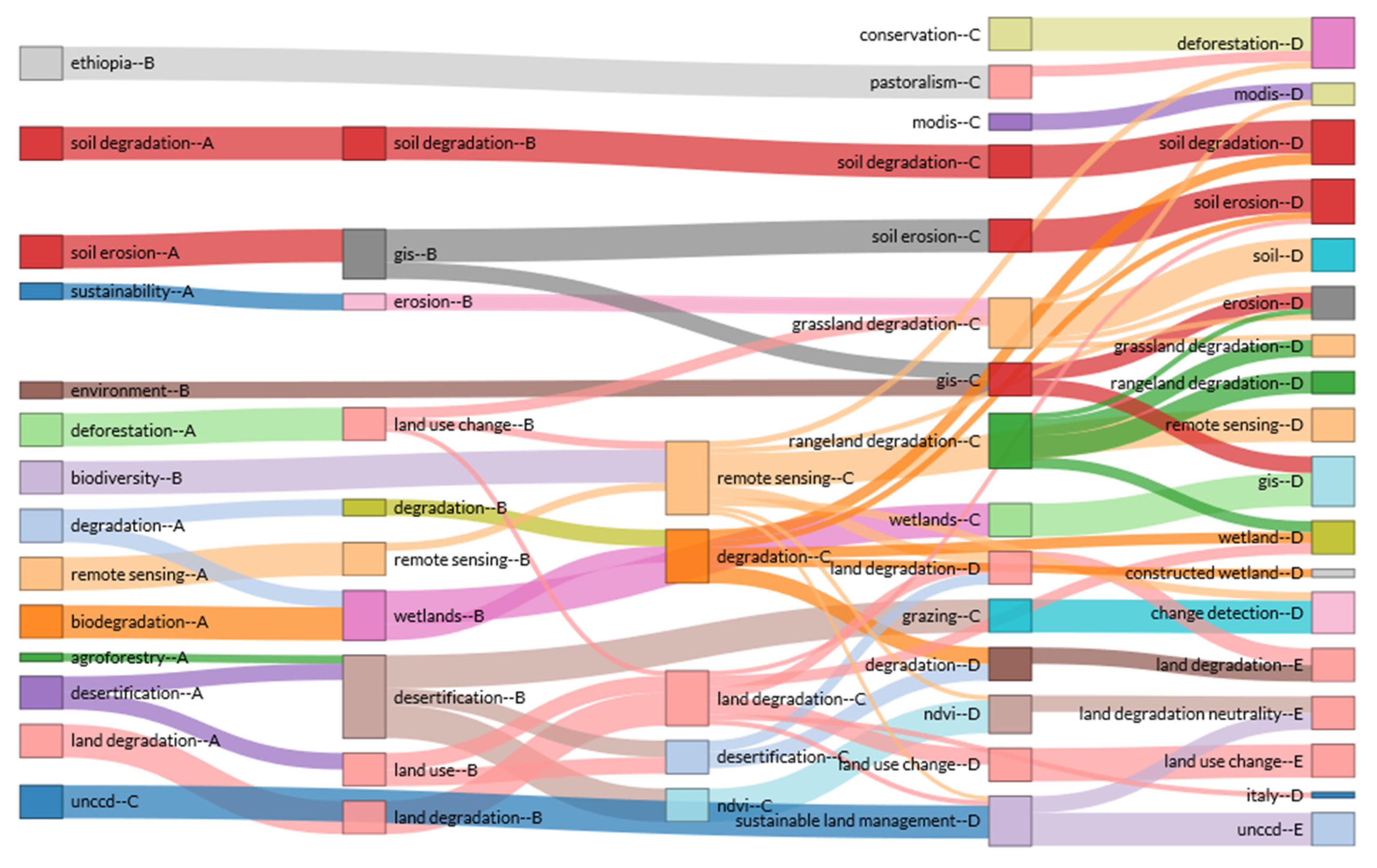
3.6. Evolution Analysis of Themes in the Field of Land Degradation

The thematic evolution analysis studies the changing rules, evolutionary relationships, evolution paths, and evolutionary trends of the thematic content, strength, and structures that occur over time. The thematic evolution analysis plays an important role in displaying field development, grasping development direction and predicting field trends [99]. The Sankey diagram, also known as the Sankey energy diffluence diagram, is a specific type of flow chart (see Figure 13). It is commonly used for data visual analysis such as energy, material composition, and finance. In this paper, based on the Sankey diagram, we visualize the thematic evolution over time in the field of land-degradation research. It helps analyze the flow conditions of different themes in the field of land degradation, and clarify quantitative information such as thematic flow, direction of thematic flow, and conversion relationships [100].
Each node in the Sankey diagram represents a topic, and the size of the node is proportional to the number of keywords included in the theme. The flow between nodes represents the evolutionary direction of the research theme. The themes in adjacent study time zones are wired to represent temporal continuity between research themes. The visual features of the line are width and color. The width is usually used to indicate the number of shared keywords. The thicker the line, the higher the relevance of the two themes. Color helps distinguish different research themes.
Thematic evolution map is used to analyze the development and extinction related to the theme of land-degradation in the whole research process, and to identify the evolutionary path of the theme from the evolution trend. From the perspective of the evolutionary path map and the evolutionary state of each period, the research in the field of land degradation is in a development stage, and the research is not mature yet. With varied research themes in different periods and complex thematic evolution relationships, the differentiation, integration, transfer, and regeneration of the themes are obvious. The evolutionary process is unstable. Since the development of the research, 15 evolutionary paths have been formed in three directions.
(1) Dynamic monitoring of land degradation. ① remote sensing→remote sensing→remote sensing→deforestation, erosion, remote sensing, change detection, NDVI (The NDVI is a dimensionless index that describes the difference between visible and near-infrared reflectance of vegetation cover and can be used to estimate the density of green on an area of land.), sustainable land management. ② GIS→soil erosion, GIS. ③ NDVI→NDVI. ④ Modis→Modis. ⑤ GIS→erosion, GIS. ⑥ NDVI→land-degradation neutrality. The number of research literatures on the dynamic monitoring of land degradation has gradually increased over time and the thematic evolution constantly took place. Land-degradation monitoring and evaluation based on 3S technology mainly relies on high-resolution and hyperspectral remote sensing data to dynamically monitor the types and extents of land degradation in watershed or key degraded areas at different scales. The monitoring and evaluation of land-degradation disasters can be carried out dynamically, effectively and quantitatively within the regional scope, so that the degradation information can be promptly fed back. For example, in order to quantitatively study the characteristics of land degradation and its driving factors, Baroudy [101] had used remote sensing and GIS technology to analyze the land degradation process in the central part of the Nile River for nearly 40 years. The results showed that the main driving factors of land degradation are water logging, salinization, alkalinization and compaction. Among the human activity factors, over-irrigation, human intervention in natural drainage, excessive use of heavy machinery, and lack of protection against land degradation were the prominent factors leading to land degradation.
With broad application prospects, although the monitoring of land degradation is low-cost, timely, and macroscopic, there still remain many technical problems to be solved. The most prominent problem is the high fluctuation of the vegetation spectrum. Firstly, due to the highly changing rate of precipitation during the annual or inter-annual period, the vegetation coverage varied randomly, affecting the determination of land-degradation information. Second, land degradation is generally consistent with the decline in vegetation cover. However, the monitoring of land degradation is also limited by the selective vegetation foraging by livestock. Moreover, relatively high vegetation coverage does not always indicate the inexistence of land degradation. Therefore, multiple remote sensing platforms, optical remote sensing images, radar remote sensing technology and other sensor technologies should be integrated, and the advantages of various remote sensing technologies should be brought into full play to improve the accuracy of land-degradation monitoring [102].
(2) Research on environmental governance of land degradation and how to achieve sustainable land use. ① sustainability → erosion. ② environment → gis. ③ biodiversity → remote sensing. ④ unccd → sustainable land management → unccd, land-degradation neutrality. ⑤ conservation → deforestation. The data of land degradation research obtained through searching are separately counted according to the number of documents in the journal (See Figure 14). With the largest document number of 130 among all journals, the journal Land Degradation & Development is known as a famous journal in the field of land degradation. Among them, Journal of Arid Environments, Catena, Environmental Management and other journals are core journals in environmental science and resource utilization. Journals such as Ecological Engineering, Ecological Indicators, and Ecological Economics are core journals in ecology. It can be concluded that the study of land degradation includes multi-discipline characteristics such as resource utilization, environmental science, and ecology, belonging to a multidisciplinary cross-disciplinary research hotspot.
Due to the long-standing problems of extensive and confused land resource management, the areas of land degradation, desertification, and salinization have been expanding. The resulting environmental problems such as serious vegetation damage, increased soil erosion, frequent natural disasters, and declining productivity have seriously affected the sustainable development of the land ecosystem [103]. So far, the practice level of ecological remediation for degraded land is not high. Besides which, ecological landscape factors and landscape patterns are rarely considered in land reclamation planning and layout. The governance and restoration of land degradation needs orienting to the ecological concept, and land should be managed from the perspective of improving the function of land ecological services, so as to achieve sustainable land development. Therefore, land reclamation should focus on ecology, the restoration of ecosystem structure and function, plant succession, biodiversity, and system self-sustainability [104]. Requier-Desjardins [105] believed that economic factors were the main factors driving land degradation and desertification. In order to raise people’s eco-environment awareness with regard to land degradation, it is also suggested to estimate the economic costs of land degradation and desertification. At the same time, it can also be a useful tool for the relevant departments to control degraded land.
(3) A study on the response of land degradation to land use change. ① land use change → grassland degradation, remote sensing. ② land use change → land degradation → soil → erosion. ③ land use change → remote sensing. ④ land use → land degradation → land degradation, wetland, land use change, sustainable land management.
Land use and land cover change (LUCC), as an important part of global change, has had a huge impact on global ecological environment. On the one hand, LUCC has a profound impact on natural environment by affecting climate, soil, hydrology and landforms. On the other hand, it has caused great changes in ecosystem biodiversity, material circulation, energy flow, and landscape structure, changing the structure and function of the ecosystem.
Land degradation is an important part of LUCC’s environmental effects. Studying land use and its dynamic changes, and identifying its impact on land degradation, play an important role in effectively preventing and mitigating land degradation, and achieving sustainable use of regional resources and environment. Scholars have done a lot of research on the temporal and spatial land-use change and the impact of land use on land degradation. For example, based on land use survey data from 1991 to 2001, Zhang [106] mapped the land-degradation distribution map with the support of the GIS spatial function. The results of the study indicated that undesirable LUCC will accelerate land degradation such as desertification, secondary salinisation, loss of agricultural use, deforestation, grassland degradation, and loss of wetland. Taking Xilingol as an example, based on multi-temporal remote sensing analysis, Batunacun [107] studied the spatial and temporal distribution characteristics of land degradation and discussed the impact of land-use change on land degradation. The results showed that the LUCC model between 1975 and 2000 is characterized by rapid urban development and sharp reduction of grassland areas. Although land has been recovered between 2000 and 2015, land degradation continues, with a degraded area of 19,124 square km2. Batunacun proposed that most ecological restoration projects were temporary. Once the environment returns to a certain critical value, the subsidies will be stopped and herders will be threatened by poverty again. Moreover, the mining industry has gradually replaced animal husbandry as an important industry in the research area, significantly affecting land-use change and land quality. The local government should explore the sustainable management of grassland resources in the context of new economic development. The impact of land-use change on land degradation involved multiple spatial and temporal scales, and the scale of impacts differed, too. Therefore, it is necessary to establish a multi-scale land-use change and land-degradation comprehensive technical method system and simulation platform to quantitatively study the land-use trends at different spatial and temporal scales and the impact of land-use change on land degradation.

4. Discussion and Conclusions

4.1. Discussion

Based on existing literatures, land-degradation research is still in the developing stage as a whole, and future research needs to be further expanded in the following aspects:
(1) Research on the process, mechanisms and effects of land degradation. For the four key land-degradation types, namely degraded cultivated land, degraded grassland, degraded forest land and degraded rangeland, it is necessary to focus on the conditions, process, influencing factors (including natural and socio-economic), and interactive mechanisms of several major degraded forms such as soil erosion, land desertification, salinization, and soil fertility loss. In the context of the study area, a combined method of quantitative and qualitative analysis is used to systematically study the mechanism, spatial, and temporal laws and development trends of land degradation. It provides a theoretical basis for land-degradation research in specific areas and the ecological reconstruction of degraded environment.
(2) Land-degradation monitoring and early warning research. Currently, several land-degradation monitoring and assessment systems have been developed in various countries. It mainly includes the establishment of a land-degradation monitoring research network by using modern technologies and means such as 3S technology, information networks, and scale conversion to monitor and evaluate the types, scales, and extent of land degradation at different scales in key regions and countries. In future, the application of new technologies and tools still needs to be strengthened for land-degradation monitoring and early warning of land degradation, including expanding the use of advanced online monitoring instruments and improving the accuracy of remote sensing monitoring. Strengthen continuous and detailed access to land-degradation information to meet the needs of land-degradation monitoring in a timely manner.
(3) Research on theories, methods, and models of ecological restoration and reconstruction of degraded land. To make up for the current defects and shortcomings of land-degradation assessment method, the scale conversion theory, landscape pattern theory, the combined advantages of landscape ecology and 3S technology in landscape ecology, and the current well-developed landscape pattern analysis method can be introduced. Therefore, the principles of ecological reconstruction of degraded land should be in line with landscape ecology theory, land use optimization allocation theory, and other relevant theories. According to local conditions, the method of ecological reconstruction of degraded land is proposed, and an effective degraded land restoration supporting technical system is developed to realize the successful restoration of various types of degraded land, thereby strengthening the sustainable use of land ecosystems.
(4) Multidisciplinary integrated system research on land degradation. Land-degradation research is a comprehensive and cross-disciplinary science. However, international and interdisciplinary cooperation is lacking, being unconducive to the long-term development of land-degradation research. Therefore, the exchange and communication on the trends and status of land degradation between experts and scholars from varied fields and countries should be strengthened. At the same time, natural science and social science should be combined so as to inspire scholars mutually to promote integration and progress in land-degradation research. In addition, authors of land-degradation research are highly concentrated, indicating that land-degradation research is mainly centered on a small number of researchers. These researchers lay a solid foundation and indicate directions for land-degradation research, but sufficient backup research force is a key factor for the long-term development of land-degradation research. Therefore, cultivating research reserve forces in the field of land degradation is an important part of the future development.
(5) Constructing a policy guarantee system for the reconstruction of degraded land. The policy mechanism is fundamental to the work of land-degradation governance. The reconstruction of degraded land should be based on local natural conditions, and analyze the current situation, causes and hazards of land degradation in various regions, so as to develop countermeasures and effective measures to prevent land degradation according to local conditions. First, countries should formulate long-term plans for land degradation prevention and control, and improve relevant policy systems and coordination mechanisms. Land preservation and soil conservation actions can be implemented through collaboration with companies and the involvement of communities. Second, the local government needs to innovate the mechanism of sustainable land management. For example, improve the policy guarantee mechanisms such as ecological compensation and poverty alleviation, producing a cost-effective mechanism for prevention and control of land degradation based on ecological, economic, and social efficiency.
(6) Strengthening research on land resource engineering. In the context of globalization, agricultural modernization and rural revitalization, land-degradation governance is not purely a land issue, but also is a multi-disciplinary issue involving many areas such as ecological protection, social economy, community development, land use, poverty eradication, and biodiversity conservation. Rural poverty is closely related to land resource endowment, quality, and utilization. The core of land engineering construction is to reconstruct the land structure, quality, and environment according to different requirements of different land uses by using the theory of land organic reconstruction, so as to meet the standards of land safety and construction. Among them, land consolidation and land development can increase the amount of land; land improvement and land allocation can improve the quality of land; land restoration and land reclamation can improve the ecological environment of land and promote sustainable land use. Therefore, countries can prevent land degradation through the above six measures, thereby improving the income level of farmers, improving the livelihood level of farmers, stimulating farmers to participate in land-degradation prevention, and finally achieving the goal of eliminating rural poverty [6].
Agricultural modernization currently faces problems such as low output efficiency, extensive use of resources, serious environmental pollution, and land degradation. Land engineering can achieve agricultural modernization and sustainable land use through the following measures to achieve standardization of agricultural products, scale of agricultural production, organizational management, and sustainable development. (I) Promote land-scale management and adjust the agricultural structure; (II) improve farmland water conservancy facilities, improve the efficiency of agricultural irrigation water resources utilization, and mitigate the impact of flood disasters on agricultural production; (III) improve the quality of the workforce, thereby promoting the use of new varieties, new technologies, and new equipment; (IV) strengthen the integration of agricultural science and technology; (V) the land project has high production efficiency, and promotes the industrial and commercial capital to enter the agricultural project for construction and operation, thus solving the initial capital investment of material equipment; this will increase the efficiency of agricultural production by putting more machinery and new technologies into agricultural production.
The main purpose of rural revitalization is to optimize the structure of elements, enhance regional functions, and reshape rural forms, so as to achieve a comprehensive revitalization of economic, social, and ecological development of rural areas, and a new pattern of urban–rural integration. Land resources shoulder the basic role of providing resources to support rural revitalization. However, rural development currently faces a large number of problems of empty waste land, unused land, and degraded land. The comprehensive improvement project of rural land can effectively integrate, allocate land resources, reconstruct the rural spatial pattern, and provide a carrier for the transformation of rural regional economic and social development. The rural land remediation project needs to follow the main will of rural people on the basis of comprehensive diagnosis and identification of the stage characteristics and realistic needs of rural development. Then, through scientific planning and design to promote the implementation of land remediation projects according to local conditions. Moreover, in the future, it is necessary to coordinate the land remediation planning and rural revitalization planning under the unified spatial planning system based on the top-level design and institutional guarantee to ensure the mutual coordination and benign interaction of the rural development factors. This will help push the implementation of the rural revitalization strategy and combat land degradation.
(7) Land-degradation prevention theory and practice innovation. In the context of globalization, land-degradation prevention is not a simple land issue, but a cross-disciplinary issue involving community development, land use, poverty eradication, and biodiversity conservation. Therefore, it is urgent to adopt innovative land-degradation prevention theories, ideas and practices to promote the sustainable land use. There must be a new concept in the prevention and control of land degradation. Future research should apply a series of richly connotative theories such as integrated ecosystem management (IEM) and strong sustainability theory to the field of land degradation, thus making a positive contribution to guiding land-degradation prevention and control. I) Integrated ecosystem management refers to an integrated management approach that manages natural resources and the environment. It requires a comprehensive treatment of all components of the ecosystem, taking into account the needs and values of society, economy, nature (including environment, resources, biology, etc.). It requires a combination of multidisciplinary knowledge and methods to comprehensively apply administrative, market, and social adjustment mechanisms to address resource use, ecological protection, and ecosystem degradation. Integrated ecosystem management does not exclude other management and conservation methods, such as sustainable management, biosphere reserves, traditional protected areas, single species conservation programmes, etc., but can integrate all of these approaches and deal with complex situations [108]. II) Sustainability theory has two perspectives: strong sustainability theory and weak sustainability theory [109]. Strong sustainability theory argues that human capital and natural capital are complementary, environmental sustainability must be guaranteed, and economic development at the expense of the environment is unsustainable. The view of weak sustainability argues that human capital and natural capital are mutual substitutes. Therefore, as long as the total amount of capital remains the same, an environment with deteriorating environment but economic development is also sustainable. Thus, in the long run, weak sustainability is actually unsustainable. Therefore, the prevention and control of land degradation should be integrated into the view of strong sustainability.
(8) Strengthen the research on the factors affecting land degradation and the types of land degradation. (I) Land degradation is the result of the interaction between natural environmental pressure and human activity pressure. The mutual driving of two major pressures is likely to cause different land-degradation processes. Therefore, quantitatively studying the characteristics and driving factors of land degradation in different research areas has important significance for realizing land-degradation neutrality [110]. (II) Land-degradation types can be divided into urban land degradation, cultivated land degradation, forest land degradation, grassland degradation, and wetland degradation according to land use types. The causes of different types of land degradation and the governance processes vary. Urban land degradation is caused by the unreasonable use of urban land such as the exploitation and commercialization of resources, the generation of waste, and unreasonable allocation. Therefore, scientific urban land-use classification and reasonable spatial planning can inhibit urban land degradation. Cultivated land degradation is caused by high-input, high-yield farming practices. Fallowing rotation, compensation for cultivated land protection, and development of ecological agriculture can promote the improvement of cultivated land-use efficiency. The problem of forest degradation caused by the sharp decline in forest area is likely to trigger an ecological crisis. Therefore, research and prevention of forest degradation needs to be carried out from the following aspects: (a) Establish a long-term monitoring network for forest ecosystem evaluation indicators. (b) Combine remote sensing analysis with a plot survey to analyze the spatial distribution and ecological processes of degraded forest ecosystems on a regional scale. Various factors such as climate change, overgrazing, mining, and chaos can cause grassland degradation. This leads to problems such as sparse vegetation, reduced soil fertility, and increased cost of grassland livestock. In view of this, grassland degradation can be suppressed by returning cultivated land to grassland and reducing the stocking rate. Water conservancy projects, wetland reclamation and urbanization have changed the water supply and demand process in wetlands, which has led to an increase in wetland degradation. In order to improve the wetland ecosystem, we should strengthen the construction of wetland nature reserves, strengthen land-use planning in wetland basins, implement wetland ecological restoration projects, establish wetland monitoring and management information systems, and improve the coordination mechanism of wetland protection management to achieve wetland protection. It can be seen that future scholars should study the prevention and control of different types of land degradation, so as to achieve the goal of sustainable and balanced development of the land ecosystem.

4.2. Conclusions

Based on the Web of Science database, literatures in the field of land degradation from 1990–2019 were retrieved, and bibliometrix and biblioshiny software packages were used for data mining and analysis. Land-degradation research presents the following characteristics and discipline:
(1) From the perspective of publication trend, the document number on land degradation continues to grow, especially after 2014, the document number increased rapidly. It can be divided into four stages: a low-production exploration period, a developmental sprout period, an expansion of promotion period, and a high-yield active period. From the perspective of paper citation, the strongest development period of land-degradation research is over the years 2002, 2005, 2007, and between 2008 and 2013. In general, attention paid to land-degradation research and scholars participating in this study have been gradually increasing over time.
(2) In terms of research power in the field, developed countries from Europe and the United States are more influential. China, a developing country, also plays an important role in the field of land degradation as a major agricultural country. Paper analysis shows that the cooperation between countries is not frequent, and papers through independent research are more common. However, this trend is not conducive to research openness or the globalization trend of scientific research.
(3) The most frequent keywords in the field of land degradation are land degradation, degradation, desertification, remote sensing, soil erosion, and soil degradation. It is concluded from the cluster analysis of high-frequency keywords in the field of land degradation that microscopic processes and mechanisms of degradation of different land types, theory and technology of restoration, reconstruction of degraded land, and sustainable use of land ecosystems would be important research directions in future research.
(4) The research theme is divided into three evolutional directions, including dynamic monitoring of land degradation, research on environmental governance of land degradation and how to achieve sustainable land use, and study of the response of land degradation to land-use change, respectively.

Author Contributions

H.X., Y.Z., Z.W., and T.L. conceptualized the research and performed the validation. H.X. and Y.Z. administered the project, developed the methodology, curated the data, conducted the formal analysis, produced visualizations, and wrote and prepared the original draft manuscript. Y.Z. and H.X. reviewed and edited the manuscript. H.X. and T.L. acquired funding. All the authors contributed to drafting the manuscript. All authors have read and agreed to the published version of the manuscript.

Funding

This study was supported by the National Natural Science Foundation of China (No. 41971243 and No. 71864016); the Academic and Technical Leaders Funding Program for Major Disciplines in Jiangxi Province (No. 20172BCB22011); the Fok Ying-Tung Fund (No. 141084); the China Postdoctoral Science Foundation (No.2017M622098); the Jiangxi Postdoctoral Science Foundation(No.2017KY55); the Humanity and Social Science Youth Foundation of the Ministry of Education of China (No. 17YJC630100); the Natural Science Foundation of Jiangxi Province (No. 20171BAA218017); the Humanities and Social Sciences Fund Project of Jiangxi Province (No. GL18242); the “13th Five-Year” planning project of Jiangxi Academy of Social Science (No.16GL31) and the Technology Foundation of Jiangxi Education Department (No. GJJ160460).

Acknowledgments

The authors thank Jingwen Liao for her contribution to the photo editing in the article. The authors would like to thank Kaifeng Duan whose suggestions greatly improved the article.

Conflicts of Interest

The authors declare no conflicts of interest.

Appendix A

Table A1. Main countries’ paper status in the field of land degradation during 1990 to 2019.
CountryArticlesFreqTotal CitationsAverage Article Citation
CHINA2390.15301307412.86
USA2020.12932690834.20
UNITED KINGDOM1150.07362293825.55
GERMANY860.05506135715.78
AUSTRALIA570.03649132723.28
ITALY570.03649109919.28
SOUTH AFRICA530.03393117322.13
SPAIN490.03137127025.92
INDIA460.029452204.78
JAPAN400.0256162515.62
CANADA370.02369128734.78
NETHERLANDS340.0217759017.35
FRANCE300.0192169023.00
BRAZIL270.0172944116.33
TURKEY240.015362088.67
ARGENTINA200.012820510.25
IRAN200.01281909.50
NEW ZEALAND200.012858029.00
POLAND200.01281688.40
THAILAND200.012820910.45
Table A2. High-frequency key words and their frequency of occurrence in the field of land degradation.
TermsFrequencyTermsFrequency
land degradation241agriculture15
degradation102constructed wetland15
desertification77land degradation neutrality15
remote sensing65wetland15
soil erosion52biodiversity14
soil degradation43drylands14
gis38grazing14
erosion34indicators14
grassland degradation31landsat14
land use31overgrazing14
climate change29rangeland degradation14
ndvi29pastoralism13
deforestation27restoration13
land use change27soil organic carbon13
soil22environment12
wetlands22forest degradation12
sustainable land management21monitoring12
italy20unccd12
biodegradation17wind erosion12
china16ecosystem services11

Appendix B

Figure A1. Sub-networks of collaboration map of authors in the field of land degradation.
Land 09 00028 g0a1aLand 09 00028 g0a1b

References

  1. Sun, T.; Feng, Z.; Yang, Y.; Lin, Y.; Wu, Y. Research on land resource carrying capacity: Progress and prospects. J. Res. Ecol. 2018, 9, 331–340. [Google Scholar]
  2. Hammad, A.; Tumeizi, A. Land degradation: Socioeconomic and environmental causes and consequences in the eastern Mediterranean. Land Degrad. Dev. 2012, 23, 216–226. [Google Scholar] [CrossRef]
  3. Batunacun; Wieland, R.; Lakes, T.; Yunfeng, H.; Nendel, C. Identifying drivers of land degradation in Xilingol, China, between 1975 and 2015. Land Use Pol. 2019, 83, 543–559. [Google Scholar] [CrossRef]
  4. Reed, M.S.; Buenemann, M.; Atlhopheng, J.; Akhtar-Schuster, M.; Bachmann, F.; Bastin, G.; Bigas, H.; Chanda, R.; Dougill, A.J.; Essahli, W.; et al. Cross-scale monitoring and assessment of land degradation and sustainable land management: A methodological framework for knowledge management. Land Degrad. Dev. 2011, 22, 261–271. [Google Scholar] [CrossRef]
  5. Salih, A.; Ganawa, E.; Elmahl, A. Spectral mixture analysis (SMA) and change vector analysis (CVA) methods for monitoring and mapping land degradation/desertification in arid and semiarid areas (Sudan), using Landsat imagery. Egypt. J. Remote Sens. Space Sci. 2017, 20, S21–S29. [Google Scholar] [CrossRef]
  6. Liu, Y.; Wang, J.; Deng, X. Rocky land desertification and its driving forces in the karst areas of rural Guangxi, Southwest China. J. Mt. Sci. 2008, 5, 350–357. [Google Scholar] [CrossRef]
  7. Winslow, M.; Akhtar-Schuster, M.; Martius, C.; Stringer, L.; Thomas, R.; Vogt, J. Special Issue on Understanding Dryland Degradation Trends. Land Degrad. Dev. 2011, 22, 145–312. [Google Scholar] [CrossRef] [Green Version]
  8. Warrena, A. Land degradation is contextual. Land Degrad. Dev. 2002, 13, 449–459. [Google Scholar] [CrossRef]
  9. Yue, Y.; Li, M.; Zhu, A.; Ye, X.; Mao, R.; Wan, J.; Dong, J. Land Degradation Monitoring in the Ordos Plateau of China Using an Expert Knowledge and BP-ANN-Based Approach. Sustainability 2016, 8, 1174. [Google Scholar] [CrossRef] [Green Version]
  10. Kust, G.; Andreeva, O.; Lobkovskiy, V.; Telnova, N. Uncertainties and policy challenges in implementing Land Degradation Neutrality in Russia. Environ. Sci. Policy 2018, 89, 348–356. [Google Scholar] [CrossRef]
  11. Abdel-Kader, F. Assessment and monitoring of land degradation in the northwest coast region, Egypt using Earth observations data. Egypt. J. Remote Sens. Space Sci. 2018. [Google Scholar] [CrossRef]
  12. Grinblat, Y.; Kidron, G.; Karnieli, A.; Benenson, I. Simulating land-use degradation in West Africa with the ALADYN model. J. Arid. Environ. 2015, 112, 52–63. [Google Scholar] [CrossRef]
  13. Keesstra, S.D.; Bouma, J.; Wallinga, J.; Tittonell, P.; Smith, P.; Cerdà, A.; Fresco, L.O. The significance of soils and soil science towards realization of the United Nations Sustainable Development Goals. Soil 2016, 2, 111–128. [Google Scholar] [CrossRef] [Green Version]
  14. Keesstra, S.; Mol, G.; De Leeuw, J.; Okx, J.; Molenaar, C.; De Cleen, M.; Visser, S. Soil-Related Sustainable Development Goals: Four Concepts to Make Land Degradation Neutrality and Restoration Work. Land 2018, 7, 133. [Google Scholar] [CrossRef] [Green Version]
  15. Hazbavi, Z.; Sadeghi, S.H.R.; Gholamalifard, M. Dynamic analysis of soil erosion-based watershed health. Geogr. Environ. Sustain. 2019, 3, 43–59. [Google Scholar] [CrossRef] [Green Version]
  16. Rodrigo-Comino, J.; Senciales, J.M.; Cerdà, A.; Brevik, E.C. The multidisciplinary origin of soil geography: A review. Earth-Sci. Rev. 2018, 177, 114–123. [Google Scholar] [CrossRef]
  17. Rodrigo-Comino, J.; Barrena-González, J.; Pulido-Fernández, M.; Cerdá, A. Estimating Non-Sustainable Soil Erosion Rates in the Tierra de Barros Vineyards (Extremadura, Spain) Using an ISUM Update. Appl. Sci. 2019, 9, 3317. [Google Scholar] [CrossRef] [Green Version]
  18. Bayat, F.; Monfared, A.B.; Jahansooz, M.R.; Esparza, E.T.; Keshavarzi, A.; Morera, A.G.; Cerdà, A. Analyzing long-term soil erosion in a ridge-shaped persimmon plantation in eastern Spain by means of ISUM measurements. Catena 2019, 183, 104176. [Google Scholar] [CrossRef]
  19. Lal, R. Tillage effects on soil degradation, soil resilience, soil quality, and sustainability. Soil Tillage Res. 1993, 27, 1–8. [Google Scholar] [CrossRef]
  20. Thomaz, E.; Luiz, J. Soil loss, soil degradation and rehabilitation in a degraded land area in Guarapuava (Brazil). Land Degrad. Dev. 2010, 23, 72–81. [Google Scholar] [CrossRef]
  21. Grum, B.; Assefa, D.; Hessel, R.; Woldearegay, K.; Kessler, A.; Ritsema, C.; Geissen, V. Effect of In Situ Water Harvesting Techniques on Soil and Nutrient Losses in Semi-Arid Northern Ethiopia. Land Degrad. Dev. 2016, 28, 1016–1027. [Google Scholar] [CrossRef] [Green Version]
  22. Mamy, L.; Vrignaud, P.; Cheviron, N.; Perreau, F.; Belkacem, M.; Brault, A. No evidence for effect of soil compaction on the degradation and impact of isoproturon. Environ. Chem. Lett. 2010, 9, 145–150. [Google Scholar] [CrossRef]
  23. Khaledian, Y.; Kiani, F.; Ebrahimi, S.; Brevik, E.; Aitkenhead-Peterson, J. Assessment and Monitoring of Soil Degradation during Land Use Change Using Multivariate Analysis. Land Degrad. Dev. 2016, 28, 128–141. [Google Scholar] [CrossRef]
  24. Young, A.; Saunders, I. Rates of surface processes and denudation. In Hillslope Processes; Abrahams, A.D., Ed.; United Kingdom: The Bin-ghamton Symposia in Geomorphology, International Series; John Wiley & Sons: Hoboken, NJ, USA, 1986; Volume 16, pp. 3–27. [Google Scholar]
  25. Koch, A.; McBratney, A.; Adams, M.; Field, D.; Hill, R.; Crawford, J. Soil Security: Solving the Global Soil Crisis. Glob. Policy 2013, 4, 434–441. [Google Scholar] [CrossRef] [Green Version]
  26. Weinzierl, T.; Wehberg, J.; Böhner, J.; Conrad, O. Spatial Assessment of Land Degradation Risk for the Okavango River Catchment, Southern Africa. Land Degrad. Dev. 2015, 27, 281–294. [Google Scholar] [CrossRef]
  27. Hazbavi, Z.; Davudirad, A.A.; Alaei, N. Overview on Land Degradation in The Industrial Shazand Watershed; LAP LAMBERT Academic Publishing: Saarbrücken, Germany, 2019. [Google Scholar]
  28. Velmourougane, K.; Blaise, D. Soil Health, Crop Productivity and Sustainability Challenges. Sustain. Chall. Agrofood Sector 2017, 21, 509–531. [Google Scholar]
  29. Ajayi, A. Land degradation and the sustainability of agricultural production in Nigeria: A review. J. Soil Sci. Environ. Manag. 2015, 6, 234–240. [Google Scholar]
  30. Hoffman, M.; Todd, S. A National Review of Land Degradation in South Africa: The Influence of Biophysical and Socio-economic Factors. J. South. Afr. Stud. 2000, 26, 743–758. [Google Scholar] [CrossRef]
  31. Bornmann, L.; Marx, W. Critical rationalism and the search for standard (field-normalized) indicators in bibliometrics. J. Informetr. 2018, 12, 598–604. [Google Scholar] [CrossRef] [Green Version]
  32. Torres, L.; Abraham, E.; Rubio, C.; Barbero-Sierra, C.; Ruiz-Pérez, M. Desertification Research in Argentina. Land Degrad. Dev. 2015, 26, 433–440. [Google Scholar] [CrossRef]
  33. Escadafal, R.; Barbero-Sierra, C.; Exbrayat, W.; Marques, M.; Akhtar-Schuster, M.; El Haddadi, A.; Ruiz, M. First Appraisal of the Current Structure of Research on Land and Soil Degradation as Evidenced by Bibliometric Analysis of Publications on Desertification. Land Degrad. Dev. 2015, 26, 413–422. [Google Scholar] [CrossRef]
  34. Zupic, I.; Cater, T. Bibliometric methods in management and organization. Organ. Res. Methods. 2015, 18, 429–472. [Google Scholar] [CrossRef]
  35. Gagolewski, M. Bibliometric impact assessment with R and the CITAN package. J. Informetr. 2011, 5, 678–692. [Google Scholar] [CrossRef]
  36. Alavifard, S. Hindex Calculator: H-index Calculator Using Data from a Web of Science (WoS) Citation Report. R PACKAGE version 1.0.0. 2015. Available online: https://CRAN.R-project.org/package=hindexcalculator (accessed on 11 September 2015).
  37. Uddin, A. scientoText: Text & Scientometric Analytics. R Package Version 0.1. 2016. Available online: https://CRAN.R-project.org/package=scientoText (accessed on 20 July 2016).
  38. Aria, M.; Cuccurullo, C. Bibliometrix: An R-tool for comprehensive science mapping analysis. J. Informetr. 2017, 11, 959–975. [Google Scholar] [CrossRef]
  39. Wessels, K.; Van den Bergh, F.; Scholes, R.J. Limits to detectability of land degradation by trend analysis of vegetation index data. Remote Sens. Environ. 2012, 125, 10–22. [Google Scholar] [CrossRef]
  40. Wessels, K.; Prince, S.; Reshef, I. Mapping land degradation by comparison of vegetation production to spatially derived estimates of potential production. J. Arid. Environ. 2008, 72, 1940–1949. [Google Scholar] [CrossRef]
  41. Evans, J.; Geerken, R. Discrimination between climate and human-induced dryland degradation. J. Arid. Environ. 2004, 57, 535–554. [Google Scholar] [CrossRef]
  42. Tong, C.; Wu, J.; Yong, S.; Yang, J.; Yong, W. A landscape-scale assessment of steppe degradation in the Xilin River Basin, Inner Mongolia, China. J. Arid. Environ. 2004, 59, 133–149. [Google Scholar] [CrossRef]
  43. Prince, S.; Becker-Reshef, I.; Rishmawi, K. Detection and mapping of long-term land degradation using local net production scaling: Application to Zimbabwe. Remote Sens. Environ. 2009, 113, 1046–1057. [Google Scholar] [CrossRef]
  44. Symeonakis, E.; Drake, N. Monitoring desertification and land degradation over sub-Saharan Africa. Int. J. Remote Sens. 2004, 25, 573–592. [Google Scholar] [CrossRef]
  45. Gisladottir, G.; Stocking, M. Land degradation control and its global environmental benefits. Land Degrad. Dev. 2005, 16, 99–112. [Google Scholar] [CrossRef]
  46. Vogt, J.V.; Safriel, U.; Von Maltitz, G.; Sokona, Y.; Zougmore, R.; Bastin, G.; Hill, J. Monitoring and assessment of land degradation and desertification: Towards new conceptual and integrated approaches. Land Degrad. Dev. 2011, 22, 150–165. [Google Scholar] [CrossRef]
  47. Contador, J.F.L.; Schnabel, S.; Gutiérrez, A.G.; Fernández, M.P. Mapping sensitivity to land degradation in Extremadura. SW Spain. Land Degrad. Dev. 2009, 20, 129–144. [Google Scholar] [CrossRef]
  48. Symeonakis, E.; Calvo-Cases, A.; Arnau-Rosalen, E. Land Use Change and Land Degradation in Southeastern Mediterranean Spain. Environ. Manag. 2007, 40, 80–94. [Google Scholar] [CrossRef] [PubMed]
  49. Ravi, S.; Breshears, D.; Huxman, T.; D’Odorico, P. Land degradation in drylands: Interactions among hydrologic–aeolian erosion and vegetation dynamics. Geomorphology 2010, 116, 236–245. [Google Scholar] [CrossRef]
  50. Pickup, G.; Bastin, G.N.; Chewings, V.H. Identifying trends in land degradation in non-equilibrium rangelands. J. Appl. Ecol. 1998, 35, 365–377. [Google Scholar] [CrossRef]
  51. Chasek, P.; Safriel, U.; Shikongo, S.; Fuhrman, V. Operationalizing Zero Net Land Degradation: The next stage in international efforts to combat desertification? J. Arid. Environ. 2015, 112, 5–13. [Google Scholar] [CrossRef]
  52. Kelly, C.; Ferrara, A.; Wilson, G.; Ripullone, F.; Nolè, A.; Harmer, N.; Salvati, L. Community resilience and land degradation in forest and shrubland socio-ecological systems: Evidence from Gorgoglione, Basilicata, Italy. Land Use Pol. 2015, 46, 11–20. [Google Scholar] [CrossRef] [Green Version]
  53. Marchi, M.; Ferrara, C.; Biasi, R.; Salvia, R.; Salvati, L. Agro-Forest Management and Soil Degradation in Mediterranean Environments: Towards a Strategy for Sustainable Land Use in Vineyard and Olive Cropland. Sustainability 2018, 10, 2565. [Google Scholar] [CrossRef] [Green Version]
  54. Stringer, L.; Twyman, C.; Thomas, D. Combating Land Degradation through Participatory Means: The Case of Swaziland. AMBIO: A J. Hum. Environ. 2007, 36, 387–393. [Google Scholar] [CrossRef]
  55. Stringer, L.; Twyman, C.; Thomas, D. Learning to reduce degradation on Swaziland’s arable land: Enhancing understandings of Striga asiatica. Land Degrad. Dev. 2007, 18, 163–177. [Google Scholar] [CrossRef]
  56. Liu, M.; Dries, L.; Heijman, W.; Huang, J.; Zhu, X.; Hu, Y.; Chen, H. The Impact of Ecological Construction Programs on Grassland Conservation in Inner Mongolia, China. Land Degrad. Dev. 2017, 29, 326–336. [Google Scholar] [CrossRef] [Green Version]
  57. Wang, L.; Zhang, J.; Liu, L. Diversification of rural livelihood strategies and its effect on local landscape restoration in the semiarid hilly area of the Loess Plateau, China. Land Degrad. Dev. 2010, 21, 433–445. [Google Scholar] [CrossRef]
  58. Lakshminarayan, P.; Gassman, P.; Bouzaher, A.; Izaurralde, R. A Metamodeling Approach to Evaluate Agricultural Policy Impact on Soil Degradation in Western Canada. Can. J. Agric. Econ-Rev. Can. Agroecon. 1996, 44, 277–294. [Google Scholar] [CrossRef]
  59. Zhang, X.; Estoque, R.C.; Xie, H.; Murayama, Y.; Ranagalage, M. Bibliometric analysis of highly cited articles on ecosystem services. PLoS ONE 2019, 14, e0210707. [Google Scholar] [CrossRef] [PubMed]
  60. Reynolds, J.; Grainger, A.; Stafford Smith, D.; Bastin, G.; Garcia-Barrios, L.; Fernández, R. Scientific concepts for an integrated analysis of desertification. Land Degrad. Dev. 2011, 22, 166–183. [Google Scholar] [CrossRef] [Green Version]
  61. Darkoh, M. The nature, causes and consequences of desertification in the drylands of Africa. Land Degrad. Dev. 1998, 9, 1–20. [Google Scholar] [CrossRef]
  62. Dharumarajan, S.; Bishop, T.; Hegde, R.; Singh, S. Desertification vulnerability index-an effective approach to assess desertification processes: A case study in Anantapur District, Andhra Pradesh, India. Land Degrad. Dev. 2017, 29, 150–161. [Google Scholar] [CrossRef]
  63. Löw, F.; Navratil, P.; Kotte, K.; Schöler, H.; Bubenzer, O. Remote-sensing-based analysis of landscape change in the desiccated seabed of the Aral Sea—A potential tool for assessing the hazard degree of dust and salt storms. Environ. Monit. Assess. 2013, 185, 8303–8319. [Google Scholar] [CrossRef]
  64. Sepehr, A.; Zucca, C. Ranking desertification indicators using TOPSIS algorithm. Nat. Hazards 2012, 62, 1137–1153. [Google Scholar] [CrossRef]
  65. Wang, C.; Wan, S.; Xing, X.; Zhang, L.; Han, X. Temperature and soil moisture interactively affected soil net N mineralization in temperate grassland in Northern China. Soil Biol. Biochem. 2006, 38, 1101–1110. [Google Scholar] [CrossRef]
  66. Zhao, X.; Zhu, H.; Dong, K.; Li, D. Plant Community and Succession in Lowland Grasslands under Saline–Alkali Conditions with Grazing Exclusion. Agron. J. 2017, 109, 2428. [Google Scholar] [CrossRef]
  67. Akiyama, T.; Kawamura, K. Grassland degradation in China: Methods of monitoring, management and restoration. Grassl. Sci. 2007, 53, 1–17. [Google Scholar] [CrossRef]
  68. Lal, R. Soil erosion impact on agronomic productivity and environment quality. Crit. Rev. Plant. Sci. 1998, 17, 319–464. [Google Scholar] [CrossRef]
  69. Moritani, S.; Yamamoto, T.; Andry, H.; Inoue, M.; Kaneuchi, T. Using digital photogrammetry to monitor soil erosion under conditions of simulated rainfall and wind. Aust. J. Soil Res. 2010, 48, 36–42. [Google Scholar] [CrossRef]
  70. Wu, X.; Wei, Y.; Wang, J.; Cai, C.; Deng, Y.; Xia, J. RUSLE erodibility of heavy-textured soils as affected by soil type, erosional degradation, and rainfall intensity: A field simulation. Land Degrad. Dev. 2018, 29, 408–421. [Google Scholar] [CrossRef]
  71. Ding, Y. Scientific collaboration and endorsement: Network analysis of coauthorship and citation networks. J. Informetr. 2011, 5, 187–203. [Google Scholar] [CrossRef] [Green Version]
  72. Mori, Y.; Kuroda, M.; Makino, N. Multiple correspondence analysis. Encycl. Meas. Stat. 2014, 29, 91–116. [Google Scholar]
  73. Woo, M.; Young, K. Hydrogeomorphology of patchy wetlands in the high arctic, polar desert environment. Wetlands 2003, 23, 291–309. [Google Scholar] [CrossRef]
  74. Seilheimer, T.; Mahoney, T.; Chow-Fraser, P. Comparative study of ecological indices for assessing human-induced disturbance in coastal wetlands of the laurentian great lakes. Ecol. Indic. 2009, 9, 81–91. [Google Scholar] [CrossRef]
  75. Jacobs, A.; Kentula, M.; Herlihy, A. Developing an index of wetland condition from ecological data: An example using HGM functional variables from the Nanticoke watershed, USA. Ecol. Indic. 2010, 10, 703–712. [Google Scholar] [CrossRef]
  76. Richardson, C.; King, R.; Qian, S.; Vaithiyanathan, P.; Stow, C. Estimating ecological thresholds for phosphorus in the everglades. Environ. Sci. Technol. 2008, 41, 8084–8091. [Google Scholar] [CrossRef] [PubMed]
  77. Lake, P.; Bond, N.; Reich, P. Linking ecological theory with stream restoration. Freshw. Biol. 2007, 52, 597–615. [Google Scholar] [CrossRef]
  78. Niedermeier, A.; Robinson, J. Hydrological controls on soil redox dynamics in a peat-based, restored wetland. Geoderma 2007, 137, 318–326. [Google Scholar] [CrossRef]
  79. Datta, S.; Sarkar, K. Threatened access, risk of eviction and forest degradation: Case study of sustainability problem in a remote rural region in india. Environ. Dev. Sustain. 2012, 14, 153–165. [Google Scholar] [CrossRef]
  80. Salvati, L.; Carlucci, M. Towards sustainability in agro-forest systems? grazing intensity, soil degradation and the socioeconomic profile of rural communities in italy. Ecol. Econ. 2015, 112, 1–13. [Google Scholar] [CrossRef]
  81. Thompson, I. Biodiversity, ecosystem thresholds, resilience and forest degradation. Unasylva 2011, 62, 25–30. [Google Scholar]
  82. Lambin, E. Monitoring forest degradation in tropical regions by remote sensing: Some methodological issues. Glob. Ecol. Biogeogr. 1999, 8, 191–198. [Google Scholar] [CrossRef]
  83. Wang, J.; Sui, L.; Yang, X.; Wang, Z.; Ge, D. Economic Globalization Impacts on the Ecological Environment of Inland Developing Countries: A Case Study of Laos from the Perspective of the Land Use/Cover Change. Sustainability 2019, 11, 3940. [Google Scholar] [CrossRef] [Green Version]
  84. Nguyen, T. Drivers of forest change in Hoa Binh, Vietnam in the context of integration and globalization. Singap. J. Trop. Geogr. 2019, 40, 452–475. [Google Scholar] [CrossRef]
  85. Li, S.; Verburg, P.; Lv, S.; Wu, J.; Li, X. Spatial analysis of the driving factors of grassland degradation under conditions of climate change and intensive use in Inner Mongolia, China. Reg. Envir. Chang. 2011, 12, 461–474. [Google Scholar] [CrossRef]
  86. Liu, Y.; Zha, Y.; Gao, J.; Ni, S. Assessment of grassland degradation near Lake Qinghai, West China, using Landsat TM andin situreflectance spectra data. Int. J. Remote Sens. 2004, 25, 4177–4189. [Google Scholar] [CrossRef]
  87. Gao, Q.; Wan, Y.; Xu, H.; Li, Y.; Jiangcun, W.; Borjigidai, A. Alpine grassland degradation index and its response to recent climate variability in Northern Tibet, China. Quat. Int. 2010, 226, 143–150. [Google Scholar] [CrossRef]
  88. Maitima, J.; Mugatha, S.; Reid, R.; Gachimbi, L.; Majule, A.; Lyaruu, H. The linkages between land use change, land degradation and biodiversity across east africa. Afr. J. Environ. Sci. Technol. 2004, 3, 310–325. [Google Scholar]
  89. De Valença, A.; Vanek, S.; Meza, K.; Ccanto, R.; Olivera, E. Land use as a driver of soil fertility and biodiversity across an agricultural landscape in the Central Peruvian Andes. Ecol. Appl. 2017, 27, 1138–1154. [Google Scholar] [CrossRef] [PubMed]
  90. Vityakon, P. Degradation and restoration of sandy soils under different agricultural land uses in northeast Thailand: A review. Land Degrad. Dev. 2007, 18, 567–577. [Google Scholar] [CrossRef]
  91. Ahirwal, J.; Maiti, S.; Singh, A. Ecological Restoration of Coal Mine-Degraded Lands in Dry Tropical Climate: What Has Been Done and What Needs to Be Done? Environ. Qual. Manag. 2016, 26, 25–36. [Google Scholar] [CrossRef]
  92. Martin, L.; Moloney, K.; Wilsey, B. An assessment of grassland restoration success using species diversity components. J. Appl. Ecol. 2005, 42, 327–336. [Google Scholar] [CrossRef]
  93. Liu, L.; Luo, X. Understanding Farmers’ Perceptions and Behaviors towards Farmland Quality Change in Northeast China: A Structural Equation Modeling Approach. Sustainability 2018, 10, 3345. [Google Scholar] [CrossRef] [Green Version]
  94. Cowie, A.; Penman, T.; Gorissen, L.; Winslow, M.; Lehmann, J.; Tyrrell, T. Towards sustainable land management in the drylands: Scientific connections in monitoring and assessing dryland degradation, climate change and biodiversity. Land Degrad. Dev. 2011, 22, 248–260. [Google Scholar] [CrossRef]
  95. Thomas, R.; Reed, M.; Clifton, K.; Appadurai, N.; Mills, A.; Zucca, C. A framework for scaling sustainable land management options. Land Degrad. Dev. 2018, 29, 3272–3284. [Google Scholar] [CrossRef] [Green Version]
  96. Ghassemi, F.; Jakeman, A.; Nix, H. Salinisation of Land and Water Resources: Human Causes, Extent, Management and Case Studies; CAB International: Wallingford, UK, 1995. [Google Scholar]
  97. Qadir, M.; Noble, A.; Schubert, S.; Thomas, R.; Arslan, A. Sodicity-induced land degradation and its sustainable management: Problems and prospects. Land Degrad. Dev. 2006, 17, 661–676. [Google Scholar] [CrossRef]
  98. Liu, Y.; Wang, Y. Rural land engineering and poverty alleviation: Lessons from typical regions in China. J. Geogr. Sci. 2019, 29, 643–657. [Google Scholar] [CrossRef] [Green Version]
  99. Cobo, M.; López-Herrera, A.; Herrera-Viedma, E.; Herrera, F. An approach for detecting, quantifying, and visualizing the evolution of a research field: A practical application to the Fuzzy Sets Theory field. J. Informetr. 2011, 5, 146–166. [Google Scholar] [CrossRef]
  100. Soundararajan, K.; Ho, H.; Su, B. Sankey diagram framework for energy and exergy flows. Appl. Energy 2014, 136, 1035–1042. [Google Scholar] [CrossRef]
  101. Baroudy, A. Monitoring land degradation using remote sensing and GIS techniques in an area of the middle Nile Delta, Egypt. Catena 2011, 87, 201–208. [Google Scholar] [CrossRef]
  102. Eckert, S.; Hüsler, F.; Liniger, H.; Hodel, E. Trend analysis of MODIS NDVI time series for detecting land degradation and regeneration in Mongolia. J. Arid. Environ. 2015, 113, 16–28. [Google Scholar] [CrossRef]
  103. Schulte, R.; Creamer, R.; Donnellan, T.; Farrelly, N.; Fealy, R.; O’Donoghue, C.; O’hUallachain, D. Functional land management: A framework for managing soil-based ecosystem services for the sustainable intensification of agriculture. Environ. Sci. Policy 2014, 38, 45–58. [Google Scholar] [CrossRef] [Green Version]
  104. Rey Benayas, J.; Bullock, J. Restoration of Biodiversity and Ecosystem Services on Agricultural Land. Ecosystems 2012, 15, 883–899. [Google Scholar] [CrossRef]
  105. Requier-Desjardins, M.; Adhikari, B.; Sperlich, S. Some notes on the economic assessment of land degradation. Land Degrad. Dev. 2010, 22, 285–298. [Google Scholar] [CrossRef]
  106. Zhang, K.; Yu, Z.; Li, X.; Zhou, W.; Zhang, D. Land use change and land degradation in China from 1991 to 2001. Land Degrad. Dev. 2007, 18, 209–219. [Google Scholar] [CrossRef]
  107. Batunacun; Nendel, C.; Hu, Y.; Lakes, T. Land-use change and land degradation on the Mongolian Plateau from 1975 to 2015-A case study from Xilingol, China. Land Degrad. Dev. 2018, 29, 1595–1606. [Google Scholar] [CrossRef]
  108. Wu, J.; Gong, Y.; Zhou, J.; Wang, X.; Gao, J.; Yan, A. The governance of integrated ecosystem management in ecological function conservation areas in China. Reg. Envir. Chang. 2013, 13, 1301–1312. [Google Scholar] [CrossRef]
  109. Wu, J. Landscape sustainability science: Ecosystem services and human well-being in changing landscapes. Landsc. Ecol. 2013, 28, 999–1023. [Google Scholar] [CrossRef]
  110. Liniger, H.; Harari, N.; Van Lynden, G.; Fleiner, R.; De Leeuw, J.; Bai, Z.; Critchley, W. Achieving land degradation neutrality: The role of SLM knowledge in evidence-based decision-making. Environ. Sci. Policy 2019, 94, 123–134. [Google Scholar] [CrossRef]
Figure 1. Bibliometrix and the recommended science mapping workflow.
Land 09 00028 g001
Figure 2. Land degradation research documents published from 1990 to 2018.
Land 09 00028 g002
Figure 3. The number of annual cited paper.
Land 09 00028 g003
Figure 4. Historical direct citation network of top-cited papers in the field of land degradation from 1990 to 2019.
Land 09 00028 g004
Figure 5. Authors’ production over time in the field of land degradation.
Land 09 00028 g005
Figure 6. Collaboration map of authors in the field of land degradation.
Land 09 00028 g006
Figure 7. Scientific production distribution in the field of land degradation.
Land 09 00028 g007
Figure 8. Country collaboration map of the countries in the field of land degradation.
Land 09 00028 g008
Figure 9. Corresponding authors’ nationalities in the 20 most-prolific countries in the field of land degradation.
Land 09 00028 g009
Figure 10. Word TreeMap of high-frequency keywords in the field of land degradation.
Land 09 00028 g010
Figure 11. Multiple correspondence analysis (MCA) of high-frequency key words in the field of land degradation.
Land 09 00028 g011
Figure 12. Tree dendrogram of hierarchical cluster analysis of key words in the field of land degradation.
Land 09 00028 g012
Figure 13. Thematic evolution of the land-degradation research (1990–2019).
Land 09 00028 g013
Figure 14. Top 30 journals with regard to land degradation papers.
Land 09 00028 g014
Table 1. Top 10 local citation scores (LCS) in land-degradation research.
DocumentsDOIYearLCSGCS
Evans J, 2004, J Arid Environ [41]10.1016/S0140-1963(03)00121-6200431248
Prince SD, 2009, Remote Sens Environ [43]10.1016/J.RSE.2009.01.01620092389
Symeonakis E, 2004, Int J Remote Sens [44]10.1080/0143116031000095998200420105
Gisladottir G, 2005, Land Degrad Dev [45]10.1002/LDR.68720052090
WarrenA, 2002, Land Degrad Dev [8]10.1002/LDR.532200219108
Vogt JV, 2011, Land Degrad Dev [46]10.1002/LDR.107520111881
Wessels KJ, 2008, J Arid Environ [40]10.1016/J.JARIDENV.2008.05.01120081763
Contador JFL, 2009, Land Degrad Dev [47]10.1002/LDR.88420091749
Reed MS, 2011, Land Degrad Dev [4]10.1002/LDR.108720111663
Wessels KJ, 2012, Remote Sens Environ [39]10.1016/J.RSE.2012.06.02220121598
Table 2. Top 10 global citation scores (GCS) in land degradation research.
PaperDOIYearLCSGCS
Evans J, 2004, J Arid Environ [41]10.1016/S0140-1963(03)00121-6200431248
Tong C, 2004, J Arid Environ [42]10.1016/J.JARIDENV.2004.01.004200413161
Ravi S, 2010, Geomorphology [49]10.1016/J.GEOMORPH.2009.11.023201011135
Warren A, 2002, Land Degrad Dev [8]10.1002/LDR.532200219108
Symeonakis E, 2004, Int J Remote Sens [44]10.1080/0143116031000095998200420105
Wessels KJ, 2012, Remote Sens Environ [39]10.1016/J.RSE.2012.06.02220121598
Pickup G, 1998, J Appl Ecol [50]10.1046/J.1365-2664.1998.00319.X19981190
Gisladottir G, 2005, Land Degrad Dev [45]10.1002/LDR.68720052090
Prince SD, 2009, Remote Sens Environ [43]10.1016/J.RSE.2009.01.01620092389
Vogt JV, 2011, Land Degrad De [46]10.1002/LDR.107520111881
Table 3. Top 10 influential authors in the field of land degradation.
Authorh-Indexg-IndexMean Citation per DocumentProduction Year_Start
Salvati L152317 2009
Stringer LC121919 2007
Dong SK81217 2012
Li YY81117 2012
Dougill AJ91036 1999
Perini L71020 2011
Zhang J61315 2005
Akhtar Schuster M7926 2011
Bajocco S6921 2011
Kosmas C6992000

