Next Issue
Volume 8, July
Previous Issue
Volume 8, May


Land, Volume 8, Issue 6 (June 2019) – 18 articles

Cover Story (view full-size image): 
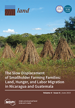
Smallholders worldwide experience processes of displacement from their lands under neoliberal governance. The displacement is often “slow” and driven by decades of agricultural policies and land governance regimes that favor input-intensive agricultural and natural resource extraction at the expense of traditional agrarian practices, markets, and producers. Smallholders struggle to remain viable in the face of these forces, yet they often experience hunger. To persist on the land, families supplement and finance farm production by engaging in international migration. Research carried out in Nicaragua and Guatemala demonstrates how smallholders use migration to address persistent hunger, with the two cases illuminating the centrality of underlying land distribution questions in migration from rural spaces of Central America. View this paper.
  • Issues are regarded as officially published after their release is announced to the table of contents alert mailing list.
  • You may sign up for e-mail alerts to receive table of contents of newly released issues.
  • PDF is the official format for papers published in both, html and pdf forms. To view the papers in pdf format, click on the "PDF Full-text" link, and use the free Adobe Reader to open them.
Order results
Result details
Section
Select all
Export citation of selected articles as:
13 pages, 4102 KiB  
Project Report
Detection of Urban Development in Uyo (Nigeria) Using Remote Sensing
by Etido Essien and Samimi Cyrus
Land 2019, 8(6), 102; https://doi.org/10.3390/land8060102 - 25 Jun 2019
Cited by 18 | Viewed by 8069
Abstract
Uyo is one of the fastest-growing cities in Nigeria. In recent years, there has been a widespread change in land use, yet to date, there is no thorough mapping of vegetation change across the area. This study focuses on land use change, urban [...] Read more.
Uyo is one of the fastest-growing cities in Nigeria. In recent years, there has been a widespread change in land use, yet to date, there is no thorough mapping of vegetation change across the area. This study focuses on land use change, urban development, and the driving forces behind natural vegetation loss in Uyo. Based on time series Landsat Thematic Mapper (TM)/Enhanced Thematic Mapper Plus (ETM+)/Operational Land Imager (OLI) image data, the relationships between urban land development and its influencing factors from 1985 to 2018 were analyzed using remote sensing (RS) and time series data. The results show eight land use cover classes. Three of these (forest, swamp vegetation, and mixed vegetation) are related to natural vegetation, and three (sparse built-up, dense built-up, and borrow pit) are direct consequences of urban infrastructure development changes to the landscape. Swamp vegetation, mixed vegetation, and forest are the most affected land use classes. Thus, the rapid growth of infrastructure and industrial centers and the rural and urban mobility of labor have resulted in an increased growth of built-up land. Additionally, the growth pattern of built-up land in Uyo corresponds with socioeconomic interviews conducted in the area. Land use changes in Uyo could be attributed to changes in economic structure, urbanization through infrastructure development, and population growth. Normalized difference vegetation index (NDVI) analysis shows a trend of decreasing vegetation in Uyo, which suggests that changes in economic structure represent a key driver of vegetation loss. Furthermore, the implementation of scientific and national policies by government agencies directed at reducing the effects of urbanization growth should be strengthened, in order to calm the disagreement between urban developers and environmental managers and promote sustainable land use. Full article
(This article belongs to the Special Issue Monitoring Land Cover Change: Towards Sustainability)
Show Figures

Figure 1

31 pages, 380 KiB  
Article
Conceptualizing Company Response to Community Protest: Principles to Achieve a Social License to Operate
by Frank Vanclay and Philippe Hanna
Land 2019, 8(6), 101; https://doi.org/10.3390/land8060101 - 20 Jun 2019
Cited by 76 | Viewed by 10611
Abstract
To gain a social license to operate and grow, companies should have effective community engagement activities, social impact assessment processes, environmental and social impact management procedures, and human rights-compatible grievance redress mechanisms in place. In this way, environmental impacts and social impacts would [...] Read more.
To gain a social license to operate and grow, companies should have effective community engagement activities, social impact assessment processes, environmental and social impact management procedures, and human rights-compatible grievance redress mechanisms in place. In this way, environmental impacts and social impacts would likely be identified and addressed before issues escalate and social risk amplifies. Companies also need to treat communities with respect and be mindful of local culture. Where these things are not done, there will be no social license to operate. Protests are mechanisms by which affected communities express their concerns and signal there is no social license. As argued in our previous work on conceptualizing social protests, protests are warning signs, as well as opportunities for companies to improve. Rather than let protest actions escalate, leading to violent confrontation and considerable cost and harm, companies should engage in meaningful dialogue with protesters. Unfortunately, company response is often inadequate or inappropriate. In this paper, we identify around 175 actions companies might take in relation to community protest, and we discuss how these actions variously have the potential to escalate or de-escalate conflict, depending on whether the company engages in appropriate and genuine interaction with protesters or if repressive measures are used. While effective engagement will likely de-escalate conflict, ignoring or repressing protests tends to provoke stronger reactions from groups seeking to have their concerns heard. When companies address community concerns early, their social license to operate is enhanced. We also outline the primary international standards companies are expected to comply with, and we identify the key environmental, social, and governance issues (ESG principles) that should be respected. Full article
(This article belongs to the Special Issue Land, Land Use and Social Issues)
21 pages, 3030 KiB  
Article
The Anti-Politics Machine of Green Energy Development: The Moroccan Solar Project in Ouarzazate and Its Impact on Gendered Local Communities
by Sarah Ryser
Land 2019, 8(6), 100; https://doi.org/10.3390/land8060100 - 20 Jun 2019
Cited by 23 | Viewed by 7621
Abstract
The Moroccan Agency for Sustainable Energy (MASEN) established one of the largest solar energy projects in the world through a public–private partnership. It is on communal land previously owned by a Moroccan Amazigh (Berber) clan in the Ghessate rural council area, 10 km [...] Read more.
The Moroccan Agency for Sustainable Energy (MASEN) established one of the largest solar energy projects in the world through a public–private partnership. It is on communal land previously owned by a Moroccan Amazigh (Berber) clan in the Ghessate rural council area, 10 km away from Ouarzazate. The land for the energy project comprises a surface area of more than 3000 hectares. This large-scale land acquisition has led to the loss of access to common-pool resources (land, water, and plants), which were formerly managed by local common property institutions, due to its enclosure, and the areas themselves. This paper outlines how the framing of the low value of land by national elites, the state administration, MASEN, and the subsequent discourses of development, act as an anti-politics machine to hide the loss of land and land-related common-pool resources, and thus an attack on resilience—we call it in our scientific discipline a process of ‘resilience grabbing’ (Resilience is the ability of a person and/or a household to restore basic livelihood capacities after shocks and hazards. Such capacities need to be available over time and remain high for the unit (household, community) to be resilient), especially for women. As a form of compensation for the land losses, economic livelihood initiatives have been introduced for local people based on the funds from the sale of the land and revenue from the solar energy project Noor Ouarzazate. The loss of land representing the ‘old’ commons is—in the official discourse—legitimated by what the government and the parastatal company call the development-related ‘fruits of growth’, and should serve as ‘new forms of commons’ to the local communities. The investment therefore acts as a catalyst through which natural resources (land, water, and plants) are institutionally transformed into new monetary resources that local actors are said to be able to access, under specific conditions, to sustain their livelihood. There are, however, pertinent questions of access (i.e., inclusion and exclusion), regulation, and equality of opportunities for meeting the different livelihood conditions previously supported by the ‘old’ commons. Full article
Show Figures

Figure 1

19 pages, 1438 KiB  
Commentary
Did Forestland Restitution Facilitate Institutional Amnesia? Some Evidence from Romanian Forest Policy
by Marian Drăgoi and Veronica Toza
Land 2019, 8(6), 99; https://doi.org/10.3390/land8060099 - 19 Jun 2019
Cited by 14 | Viewed by 3650
Abstract
This paper shows how the slow process of forestland restitution, which is unfolding in Romania since 1991 has eroded the threads of sustainable forest management by an insidious institutional amnesia (IA). The four symptoms of this harmful process (frequent reorganization, transition from paperwork [...] Read more.
This paper shows how the slow process of forestland restitution, which is unfolding in Romania since 1991 has eroded the threads of sustainable forest management by an insidious institutional amnesia (IA). The four symptoms of this harmful process (frequent reorganization, transition from paperwork to electronic media, fewer people motivated to join public services, and popularity of radical changes) were analyzed from the legal standing point as well as from practitioners’ perspective. After having described the legal process and the relative dependencies between laws and government ordinances we also showed that the three laws on forestland restoration (three fully operational laws and two bills submitted in 2019, one year before general elections) were produced by unintended policy arrangements. The legal loopholes of forestland restitution were described in details as well as the challenges brought about by nature conservation policy (Natura 2000 management plans v traditional forest planning), and the overwhelming bureaucratic burden developed to deter illegal logging, instead of fully implementing a modern system of forest watching based on volunteering. However, the main cause of IA is institutional unsteadiness which was inherited from the communist regime, and cannot be alleviated unless more involvement of professional foresters in politics. Full article
Show Figures

Figure 1

12 pages, 6391 KiB  
Conference Report
The Future of Traditional Landscapes: Discussions and Visions
by Hans Renes, Csaba Centeri, Alexandra Kruse and Zdeněk Kučera
Land 2019, 8(6), 98; https://doi.org/10.3390/land8060098 - 18 Jun 2019
Cited by 14 | Viewed by 4460
Abstract
At the 2018 meeting of the Permanent European Conference for the Study of the Rural Landscape (PECSRL), that took place in Clermont-Ferrand and Mende in France, the Institute for Research on European Agricultural Landscapes e.V. (EUCALAND) Network organized a session on traditional landscapes. [...] Read more.
At the 2018 meeting of the Permanent European Conference for the Study of the Rural Landscape (PECSRL), that took place in Clermont-Ferrand and Mende in France, the Institute for Research on European Agricultural Landscapes e.V. (EUCALAND) Network organized a session on traditional landscapes. Presentations included in the session discussed the concept of traditional, mostly agricultural, landscapes, their ambiguous nature and connections to contemporary landscape research and practice. Particular attention was given to the connection between traditional landscapes and regional identity, landscape transformation, landscape management, and heritage. A prominent position in the discussions was occupied by the question about the future of traditional or historical landscapes and their potential to trigger regional development. Traditional landscapes are often believed to be rather stable and slowly developing, of premodern origin, and showing unique examples of historical continuity of local landscape forms as well as practices. Although every country has its own traditional landscapes, globally seen, they are considered as being rare; at least in Europe, also as a consequence of uniforming CAP (Common Agricultural Policy) policies over the last five decades. Although such a notion of traditional landscapes may be criticized from different perspectives, the growing number of bottom-up led awareness-raising campaigns and the renaissance of traditional festivities and activities underline that the idea of traditional landscapes still contributes to the formation of present identities. The strongest argument of the growing sector of self-marketing and the increasing demand for high value, regional food is the connection to the land itself: while particular regions and communities are promoting their products and heritages. In this sense, traditional landscapes may be viewed as constructed or invented, their present recognition being a result of particular perceptions and interpretations of local environments and their pasts. Nevertheless, traditional landscapes thus also serve as a facilitator of particular social, cultural, economic, and political intentions and debates. Reflecting on the session content, four aspects should be emphasized. The need for: dynamic landscape histories; participatory approach to landscape management; socioeconomically and ecologically self-sustaining landscapes; planners as intermediaries between development and preservation. Full article
(This article belongs to the Special Issue European Landscapes and Quality of Life)
Show Figures

Figure 1

25 pages, 1548 KiB  
Article
Denitrification Rate and Its Potential to Predict Biogenic N2O Field Emissions in a Mediterranean Maize-Cropped Soil in Southern Italy
by Annachiara Forte and Angelo Fierro
Land 2019, 8(6), 97; https://doi.org/10.3390/land8060097 - 17 Jun 2019
Cited by 4 | Viewed by 2704
Abstract
The denitrification rate in C2H2-amended intact soil cores and soil N2O fluxes in closed static chambers were monitored in a Mediterranean irrigated maize-cropped field. The measurements were carried out during: (i) a standard fertilization management (SFM) activity [...] Read more.
The denitrification rate in C2H2-amended intact soil cores and soil N2O fluxes in closed static chambers were monitored in a Mediterranean irrigated maize-cropped field. The measurements were carried out during: (i) a standard fertilization management (SFM) activity and (ii) a manipulation experimental (ME) test on the effects of increased and reduced application rates of urea at the late fertilization. In the course of the SFM, the irrigations following early and late nitrogen fertilization led to pulses of denitrification rates (up to 1300 μg N2O-N m−2 h−1) and N2O fluxes (up to 320 μg N2O-N m−2 h−1), thanks to the combined action of high soil temperatures and not limiting nitrates and water filled pore space (WFPS). During the ME, high soil nitrates were noted in all the treatments in the first one month after the late fertilization, which promoted marked N-losses by microbial denitrification (from 500 to 1800 μg N2O-N m−2 h−1) every time the soil WFPS was not limiting. At similar maize yield responses to fertilizer treatments, this result suggested no competition for N between plant roots and soil microbial community and indicated a probable surplus of nitrogen fertilizer input at the investigated farm. Correlation and regression analyses (CRA) on the whole set of data showed significant relations between both the denitrification rates and the N2O fluxes with three soil physical-chemical parameters: nitrate concentration, WFPS and temperature. Specifically, the response functions of denitrification rate to soil nitrates, WFPS and temperature could be satisfactorily modelled according to simple Michaelis-Menten kinetic, exponential and linear functions, respectively. Furthermore, the CRA demonstrated a significant exponential relationship between N2O fluxes and denitrification and simple empirical functions to predict N2O emissions from the denitrification rate appeared more fitting (higher concordance correlation coefficient) than the predictive empirical algorithm based on soil nitrates, WFPS and temperature. In this regard, the empirically established relationships between the denitrification rate on intact soil cores under field conditions and the soil variables provided local-specific threshold values and coefficients which may effectively work to calibrate and adapt existing N2O process-based simulation models to the local pedo-climatic conditions. Full article
Show Figures

Figure 1

15 pages, 436 KiB  
Review
Mutual Effects of Land Distribution and Economic Development: Evidence from Asia, Africa, and Latin America
by Hossein Azadi and Eric Vanhaute
Land 2019, 8(6), 96; https://doi.org/10.3390/land8060096 - 15 Jun 2019
Cited by 16 | Viewed by 8883
Abstract
Land plays an important role in the economies of developing countries, and many theories connecting land inequality with different dimensions of economic development already exist. Even though efficacious land distribution allows societies to transition from poverty to a human capital-based developed economy, ongoing [...] Read more.
Land plays an important role in the economies of developing countries, and many theories connecting land inequality with different dimensions of economic development already exist. Even though efficacious land distribution allows societies to transition from poverty to a human capital-based developed economy, ongoing issues related to property rights, inequality, and the political economy of land distribution are unavoidable. The general objective of this paper is to explore the nexus between land distribution and economic development. The specific objectives are to: (i) identify which land distribution programs/activities contribute to economic development; (ii) investigate the role of stakeholders in land distribution programs that affect the growth of productivity; and (iii) assess the deficiencies of current land distribution policies in Asia, Africa, and Latin America to explore how economic development theories contribute to decreasing income inequality. This paper provides an overview of land distribution history and the main economic development theories. It also highlights the links between land distribution and the main elements of economic development. Finally, it provides a comparative review of the most recent empirical works regarding the characteristics, limitations, and potential (mutual) effects of land distribution and economic development settings on developing countries worldwide. Full article
Show Figures

Figure 1

11 pages, 3537 KiB  
Communication
Assessing Conflict Driven Food Security in Rakhine, Myanmar with Multisource Imagery
by Xiaodong Huang, Beth Ziniti and Nathan Torbick
Land 2019, 8(6), 95; https://doi.org/10.3390/land8060095 - 14 Jun 2019
Cited by 9 | Viewed by 4901
Abstract
Recent conflict along the border of Bangladesh and Myanmar has amplified a food security crisis and access to the region remains challenging. Moderate-resolution satellite remote sensing offers an approach to complement more traditional food insecurity hot spot assessment across Rakhine, Myanmar; however, conflict [...] Read more.
Recent conflict along the border of Bangladesh and Myanmar has amplified a food security crisis and access to the region remains challenging. Moderate-resolution satellite remote sensing offers an approach to complement more traditional food insecurity hot spot assessment across Rakhine, Myanmar; however, conflict creates unique signals that are not agroclimatologically driven and need to be considered. Time series radar and optical data cubes were built and used to assess for deviations across space and time for rice paddy production areas based on established techniques. Ultimately, the Sentinel-1 radar was more helpful compared to fused Landsat-7 and -8 and Sentinel-2 data cubes that were substantially impacted by cloud cover during key growth stages. Anecdotal reporting, very high resolution (VHR) imagery, and expert knowledge were used to support operational analyses routines in an attempt to characterize rice into failed, abandoned, and cultivated classes across 2016 to 2018 seasons. Accuracy assessment using co-timed VHR showed overall accuracy (%) of 86.5, 87.5, and 91.0 for 2016, 2017, and 2018, respectively. Nearly one-third of rice production was characterized as failed or abandoned in any given year. Qualitative analyses showed paddy failure was often adjacent to conflict events. The moderate-resolution imagery and automated routines offer complementing metrics that can be used to help guide food security assessments. In regions where climate change, migration, and conflict coincide, decision support tools will need to evolve and continue to integrate human perspectives. Full article
(This article belongs to the Special Issue Agricultural Land Abandonment: Patterns, Drivers and Consequences)
Show Figures

Figure 1

21 pages, 1022 KiB  
Article
Land Deals, Wage Labour, and Everyday Politics
by Adwoa Yeboah Gyapong
Land 2019, 8(6), 94; https://doi.org/10.3390/land8060094 - 13 Jun 2019
Cited by 16 | Viewed by 4550
Abstract
This article explores the question of political struggles for inclusion on an oil palm land deal in Ghana. It examines the employment dynamics and the everyday politics of rural wage workers on a transnational oil palm plantation which is located in a predominantly [...] Read more.
This article explores the question of political struggles for inclusion on an oil palm land deal in Ghana. It examines the employment dynamics and the everyday politics of rural wage workers on a transnational oil palm plantation which is located in a predominantly migrant and settler society where large-scale agricultural production has only been introduced within the past decade. It shows that, by the nature of labour organization, as well as other structural issues, workers do not benefit equally from their work on plantations. The main form of farmworkers’ political struggles in the studied case has been the ‘everyday forms of resistance’ against exploitation and for better terms of incorporation. Particularly, they express agency through acts such as absenteeism and non-compliance, as well as engaging in other productive activities which enable them to maintain their basic food sovereignty/security. Nonetheless, their multiple and individualized everyday politics are not necessarily changing the structure of social relations associated with capitalist agriculture. Overall, this paper contributes to the land grab literature by providing context specific dynamics of the impacts of, and politics around land deals, and how they are shaped by a multiplicity of factors-beyond class. Full article
Show Figures

Figure 1

10 pages, 748 KiB  
Communication
Environment of Viewpoint Geosites: Evidence from the Western Caucasus
by Anna V. Mikhailenko and Dmitry A. Ruban
Land 2019, 8(6), 93; https://doi.org/10.3390/land8060093 - 13 Jun 2019
Cited by 19 | Viewed by 2779
Abstract
Viewpoint geological and geomorphological heritage sites (geosites and geomorphosites) offer panoramic views over unique geological features and landscapes dominated by significant features. The environmental context is of crucial importance for these sites. Three components of a viewpoint geosite environment are proposed: standpoint environment, [...] Read more.
Viewpoint geological and geomorphological heritage sites (geosites and geomorphosites) offer panoramic views over unique geological features and landscapes dominated by significant features. The environmental context is of crucial importance for these sites. Three components of a viewpoint geosite environment are proposed: standpoint environment, transitional environment, and target environment. Each can be evaluated with a set of criteria such as presence of geological and geoheritage elements, presence and type of vegetation cover, anthropogenic intervention, and degree of fragmentation and contrast. Three examples of viewpoint geosites from the Western Caucasus are analyzed. It is shown that all three demonstrate differences between the noted components of viewpoint geosite environment. Moreover, the differences between these geosites result from their environmental differences and less from differences of their displayed geoheritage. Broad applications and further justifications of the environmental evaluation method of viewpoint geosites are recommended. Full article
Show Figures

Graphical abstract

14 pages, 2952 KiB  
Article
Determining Land Management Zones Using Pedo-Geomorphological Factors in Potential Degraded Regions to Achieve Land Degradation Neutrality
by Ali Keshavarzi, Vinod Kumar, Eduardo Leonel Bottega and Jesús Rodrigo-Comino
Land 2019, 8(6), 92; https://doi.org/10.3390/land8060092 - 07 Jun 2019
Cited by 15 | Viewed by 3896
Abstract
The proper delineation of site-specific management zones is very important in the agricultural land management of potentially degraded areas. There is a necessity for the development of prospective tools in management plans to correctly understand the land degradation processes. In order to accomplish [...] Read more.
The proper delineation of site-specific management zones is very important in the agricultural land management of potentially degraded areas. There is a necessity for the development of prospective tools in management plans to correctly understand the land degradation processes. In order to accomplish this, we present a pedo-geomorphological approach using soil texture, land elevation and flow vector aspects to distinguish different management zones and to discretize soil micronutrients. To achieve this goal, we conducted the study in the Neyshabur plain, Northeast Iran. For data collection, grid sampling (500 × 500 m) was used with 70 specific points. Soil samples were collected in triplicates from various sites as composite samples (0–30 cm) to analyse clay, Zn, Mn, Cu and Fe. Using the altitude information (obtained with GPS at each sampling point), flow vectors were also modelled for all selected points. Based on the values of altitude, flow vectors and clay, management zones were delimited using geographic information systems. The best data organization was obtained from the combination of clay + elevation + flow vector attributes, generating two different management zones. In this circumstance, the lowest fuzzy performance index (FPI) and modified partition entropy (MPE) values were generated. It can be observed that the management zone 1 (MZ1) is located in the areas with a lower elevation and higher content of clay. On the other hand, the MZ2 was characterized by areas with a higher elevation and lower clay content. This study concluded that the design of management zones, using pedo-geomorphological information could reduce the time and cost of sampling necessary to assess potentially degraded areas of land. Full article
(This article belongs to the Special Issue Land Degradation Neutrality (LDN))
Show Figures

Figure 1

10 pages, 704 KiB  
Article
Effect of Land Acquisition and Compensation on the Livelihoods of People in Quang Ninh District, Quang Binh Province: Labor and Income
by Tran Tuan NGUYEN, Gábor HEGEDŰS and Tien Long NGUYEN
Land 2019, 8(6), 91; https://doi.org/10.3390/land8060091 - 05 Jun 2019
Cited by 28 | Viewed by 5809
Abstract
Researchers and development practitioners have an interest in the relationship between land and rural livelihoods. In this context, agricultural land is being increasingly lost because of developing industrialization in the provinces of Vietnam. The livelihoods of people, whose land is appropriated, are affected. [...] Read more.
Researchers and development practitioners have an interest in the relationship between land and rural livelihoods. In this context, agricultural land is being increasingly lost because of developing industrialization in the provinces of Vietnam. The livelihoods of people, whose land is appropriated, are affected. Therefore, this article investigates the impact of land acquisition and compensation on the labor and income of people when the State acquires their land to construct Industrial park projects. For the research methods, secondary data from select governmental agencies were gathered, and 50 households were interviewed to collect primary data. The results of this research indicated that although household livelihoods have been reconstructed after land acquisition, many issues are also emerging that may challenge equitable and sustainable development. These include a high proportion of households with insufficient employment, as well as those that are spending compensation money in ways that do not generate income. Full article
(This article belongs to the Special Issue Land Cover/Land-Use Changes in South and Southeast Asia)
Show Figures

Figure 1

25 pages, 7497 KiB  
Article
Multi-Criteria Decision Analysis for the Land Evaluation of Potential Agricultural Land Use Types in a Hilly Area of Central Vietnam
by Ronja Herzberg, Tung Gia Pham, Martin Kappas, Daniel Wyss and Chau Thi Minh Tran
Land 2019, 8(6), 90; https://doi.org/10.3390/land8060090 - 03 Jun 2019
Cited by 49 | Viewed by 8282
Abstract
Land evaluation is a process that is aimed at the sustainable development of agricultural production in rural areas, especially in developing countries. Therefore, land evaluation involves many aspects of natural conditions, economic, and social issues. This research was conducted in a hilly region [...] Read more.
Land evaluation is a process that is aimed at the sustainable development of agricultural production in rural areas, especially in developing countries. Therefore, land evaluation involves many aspects of natural conditions, economic, and social issues. This research was conducted in a hilly region of Central Vietnam to assess the land suitability of potential agricultural land use types that are based on scientific and local knowledge. In the frame of this research, Participatory Rural Appraisal (PRA); Analytical Hierarchy Analysis (AHP); Geographic Information System (GIS); and, scoring based scientific literature and local knowledge were applied for Multi-Criteria Decision Analysis (MCDA) for land use evaluation. The results of the PRA survey reveal that five plants offer great agricultural potential in the research area, namely rice, cassava, acacia, banana, and rubber. The land suitability of each plant type varies, depending on physical conditions as well as economic and social aspects. Acacia and cassava represent the most suitable plant types in the research area. Recommendations regarding agricultural land use planning in the A Luoi district are brought forward based on the land evaluation results. The combination of scientific and local knowledge in land assessment based on GIS technology, AHP, and PRA methods is a promising approach for land evaluation. Full article
Show Figures

Graphical abstract

12 pages, 474 KiB  
Article
The Slow Displacement of Smallholder Farming Families: Land, Hunger, and Labor Migration in Nicaragua and Guatemala
by Lindsey Carte, Birgit Schmook, Claudia Radel and Richard Johnson
Land 2019, 8(6), 89; https://doi.org/10.3390/land8060089 - 03 Jun 2019
Cited by 28 | Viewed by 8686
Abstract
Smallholders worldwide continue to experience processes of displacement from their lands under neoliberal political-economic governance. This displacement is often experienced as “slow”, driven by decades of agricultural policies and land governance regimes that favor input-intensive agricultural and natural resource extraction and export projects [...] Read more.
Smallholders worldwide continue to experience processes of displacement from their lands under neoliberal political-economic governance. This displacement is often experienced as “slow”, driven by decades of agricultural policies and land governance regimes that favor input-intensive agricultural and natural resource extraction and export projects at the expense of traditional agrarian practices, markets, and producers. Smallholders struggle to remain viable in the face of these forces, yet they often experience hunger. To persist on the land, often on small parcels, families supplement and finance farm production with family members engaging in labor migration, a form of displacement. Outcomes, however, are uneven and reflect differences in migration processes as well as national and local political economic processes around land. To demonstrate “slow displacement”, we assess the prolonged confluence of land access, hunger, and labor migration that undermine smallholder viability in two separate research sites in Nicaragua and Guatemala. We draw on evidence from in-depth interviews and focus groups carried out from 2013 to 2015, together with a survey of 317 households, to demonstrate how smallholders use international labor migration to address persistent hunger, with the two cases illuminating the centrality of underlying land distribution questions in labor migration from rural spaces of Central America. We argue that smallholder farming family migration has a dual nature: migration is at once evidence of displacement, as well as a strategy for families to prolong remaining on the land in order to produce food. Full article
Show Figures

Figure 1

13 pages, 238 KiB  
Perspective
War-Induced Displacement: Hard Choices in Land Governance
by Gemma van der Haar and Mathijs van Leeuwen
Land 2019, 8(6), 88; https://doi.org/10.3390/land8060088 - 01 Jun 2019
Cited by 5 | Viewed by 3675
Abstract
Civil war and violence often force large numbers of people to leave their lands. Multiple waves of displacement and (partial) return generate complex overlapping claims that are not easily solved. As people return to their regions of origin—sometimes after decades—they tend to find [...] Read more.
Civil war and violence often force large numbers of people to leave their lands. Multiple waves of displacement and (partial) return generate complex overlapping claims that are not easily solved. As people return to their regions of origin—sometimes after decades—they tend to find their land occupied by other settlers, some of whom hold legal entitlements. In the places of arrival, displaced people affect other people’s access as they seek to turn their temporary entitlements into more definite claims. The overlapping claims related to displacement pose serious dilemmas to land governance, which existing land laws and land governance institutions are not well-equipped to deal with. This paper outlines the main challenges for land governance as a first step to move the debate forward. The paper summarises the key challenges around three tensions: first, between short term conflict resolution and structural solutions; second, between state and customary/community-based governance; and finally, between principles (such as the right to return or restitution) and acknowledgement of the new situation. Full article
16 pages, 1425 KiB  
Article
Evaluation of Land Intensive Use in Shanghai Pilot Free Trade Zone
by Liangliang Zhou, Yishao Shi and Xiangyang Cao
Land 2019, 8(6), 87; https://doi.org/10.3390/land8060087 - 31 May 2019
Cited by 13 | Viewed by 4258
Abstract
Free trade zones represent an important system innovation space to realize economic agglomeration advantages with high-level openings. However, its evaluation of land intensive use has not received enough attention. The goal of this paper is to build a land use performance evaluation index [...] Read more.
Free trade zones represent an important system innovation space to realize economic agglomeration advantages with high-level openings. However, its evaluation of land intensive use has not received enough attention. The goal of this paper is to build a land use performance evaluation index system in line with the development trend of industrial economy and the characteristics of mixed land use in the free trade zones. An evaluation index system is constructed based on the three factors of land use status, land use efficiency and pilot free trade zone influence. Using the Delphi method and the entropy method, an empirical evaluation of the intensive land use level in the Shanghai Pilot Free Trade Zone is conducted. The results show the following: (1) integrating new indicators such as the free trade zone influence, social and ecological benefits into the evaluation index system show a characteristic and innovative land use evaluation; (2) in terms of the level of intensive land use, the Waigaoqiao Free Trade Zone has the highest intensity, followed by the Yangshan Free Trade Port Zone, and the Pudong Airport Comprehensive Free Trade Zone has the lowest intensity; and (3) development time, degree of land use, differences in leading functions, industrial land structures, and the diversification of employment structures are important factors that influence the differences in the levels of intensive land use in the Shanghai Pilot Free Trade Zone. This study also expands the performance evaluation of industrial land to the performance evaluation of construction land and provides references for industrial transformation and urban renewal of the Shanghai Pilot Free Trade Zone. Full article
Show Figures

Figure 1

12 pages, 243 KiB  
Article
Microhabitats Affect Population Size and Plant Vigor of Three Critically Endangered Endemic Plants in Southern Sinai Mountains, Egypt
by Amal M. Fakhry, Ali El-Keblawy, Hatem A. Shabana, Ibrahim El Gamal and Amir Shalouf
Land 2019, 8(6), 86; https://doi.org/10.3390/land8060086 - 31 May 2019
Cited by 10 | Viewed by 3005
Abstract
Endemic species on mountains often have narrow altitudinal ranges and are more threatened at the higher altitudes, especially with climate changes. However, plants could use special microhabitats at the mountain tops as proper places for surviving the climate change (i.e., refugia). We assessed [...] Read more.
Endemic species on mountains often have narrow altitudinal ranges and are more threatened at the higher altitudes, especially with climate changes. However, plants could use special microhabitats at the mountain tops as proper places for surviving the climate change (i.e., refugia). We assessed population attributes of three critically endangered endemic species (Primula boveana Decne ex Duby, Rosa arabica Crep., and Silene leucophylla Boiss.) in two growing seasons (2006/2007 and 2013/2014), differing in the received rainfalls in microhabitats at the high mountains of southern Sinai. Both P. boveana and S. leucophylla had very small population size, but significantly increased in the 2013/2014 growing season which received above average rainfalls. The population of R. arabica is the smallest (around 40 individuals) and did not increase, even after the increase in rainfalls. Whereas P. boveana is present in fewer sites and grew in small number of specific microhabitats, both S. leucophylla and R. arabica were recorded in most studied sites and habitat types. Unlike R. arabica, both P. boveana and S. leucophylla were recorded in caves and steep slopes and on the top of the mountains. This indicates that these sheltered mist microhabitats are the best for future conservation of these species after climate change. Full article
(This article belongs to the Special Issue Multifunctional landscapes)
28 pages, 3519 KiB  
Review
Landscape—A Review with a European Perspective
by Katia Talento, Miguel Amado and Josè Carlos Kullberg
Land 2019, 8(6), 85; https://doi.org/10.3390/land8060085 - 28 May 2019
Cited by 8 | Viewed by 5255
Abstract
This article aims to act as a general literature review regarding the landscape, analyzing it through a synthesis of the main concepts and processes that have generated, and subsequently developed, the word “Landscape”. It is a versatile theme, because it has always been [...] Read more.
This article aims to act as a general literature review regarding the landscape, analyzing it through a synthesis of the main concepts and processes that have generated, and subsequently developed, the word “Landscape”. It is a versatile theme, because it has always been studied by various disciplines, through different theories, which sometimes even conflict with each other. Through the present text, we understand the importance and the unique value of the landscape, a value that has nowadays been transfigured by the strong industrialization and strong brand of man in the territory. Thus, the first part of the research is, to some extent, a reflection on current issues that are related to the landscape. It is also a tool for integration, including in the definition of “Landscape”, even those heavily humanized, exploited, degraded, abandoned, and residual; the so-called “Drosscape”, “Friche”, and “Terrain Vague”. The solution is not to negatively interpret these types of scenarios, but rather to enhance them as they are, filled with potential and creativity. This concept is achieved by means of an operation of recycling or reuse of waste, which is capable of germinating new life cycles within the “dead nature” of our increasingly cemented territories. Full article
Show Figures

Graphical abstract

Previous Issue
Next Issue
Back to TopTop