Next Issue
Volume 8, April
Previous Issue
Volume 8, February


Land, Volume 8, Issue 3 (March 2019) – 14 articles

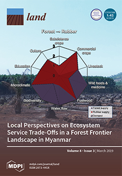
Cover Story (view full-size image): Extensive land use changes in forest frontier landscapes affect the supply of ecosystem services (ES), as well as human well-being. This study assesses the trade-offs experienced with respect to 10 locally important ES from land user perspectives using social valuation techniques in the Tanintharyi Region of Myanmar, a forest frontier landscape facing the expansion of oil palm and rubber plantations. The results show that while intact forests provide the most highly valued ES bundle, the conversion to rubber plantations causes fewer negative trade-offs than that to oil palm plantations. The study concludes that, from local perspectives, the impact of ES trade-offs highly depends on access to land and opportunities to adapt to change. View this paper
  • Issues are regarded as officially published after their release is announced to the table of contents alert mailing list.
  • You may sign up for e-mail alerts to receive table of contents of newly released issues.
  • PDF is the official format for papers published in both, html and pdf forms. To view the papers in pdf format, click on the "PDF Full-text" link, and use the free Adobe Reader to open them.
Order results
Result details
Section
Select all
Export citation of selected articles as:
14 pages, 6330 KiB  
Article
Ecosystem Productivity and Water Stress in Tropical East Africa: A Case Study of the 2010–2011 Drought
by Eugene S. Robinson, Xi Yang and Jung-Eun Lee
Land 2019, 8(3), 52; https://doi.org/10.3390/land8030052 - 22 Mar 2019
Cited by 9 | Viewed by 3826
Abstract
Characterizing the spatiotemporal patterns of ecosystem responses to drought is important in understanding the impact of water stress on tropical ecosystems and projecting future land cover transitions in the East African tropics. Through the analysis of satellite measurements of solar-induced chlorophyll fluorescence (SIF) [...] Read more.
Characterizing the spatiotemporal patterns of ecosystem responses to drought is important in understanding the impact of water stress on tropical ecosystems and projecting future land cover transitions in the East African tropics. Through the analysis of satellite measurements of solar-induced chlorophyll fluorescence (SIF) and the normalized difference vegetation index (NDVI), soil moisture, rainfall, and reanalysis data, here we characterize the 2010–2011 drought in tropical East Africa. The 2010–2011 drought included the consecutive failure of rainy seasons in October–November–December 2010 and March–April–May 2011 and extended further east and south compared with previous regional droughts. During 2010–2011, SIF, a proxy of ecosystem productivity, showed a concomitant decline (~32% lower gross primary productivity, or GPP, based on an empirical SIF–GPP relationship, as compared to the long-term average) with water stress, expressed by lower precipitation and soil moisture. Both SIF and NDVI showed a negative response to drought, and SIF captured the response to soil moisture with a lag of 16 days, even if it had lower spatial resolution and much smaller energy compared with NDVI, suggesting that SIF can also serve as an early indicator of drought in the future. This work demonstrates the unique characteristics of the 2010–2011 East African drought and the ability of SIF and NDVI to track the levels of water stress during the drought. Full article
(This article belongs to the Special Issue Global Vegetation and Land Surface Dynamics in a Changing Climate)
Show Figures

Figure 1

18 pages, 2691 KiB  
Article
Mapping the Loss of Ecosystem Services in a Region Under Intensive Land Use Along the Southern Coast of South Africa
by Hanlie Malherbe, Stephan Pauleit and Carsten Lorz
Land 2019, 8(3), 51; https://doi.org/10.3390/land8030051 - 21 Mar 2019
Cited by 9 | Viewed by 4802
Abstract
Intensive land use activities worldwide have caused considerable loss to many ecosystem services. The dynamics of these threats must be quickly investigated to ensure timely update of management strategies and policies. Compared with complex models, mapping approaches that use scoring matrices to link [...] Read more.
Intensive land use activities worldwide have caused considerable loss to many ecosystem services. The dynamics of these threats must be quickly investigated to ensure timely update of management strategies and policies. Compared with complex models, mapping approaches that use scoring matrices to link land use/land cover and landscape properties with ecosystem services are relatively efficient and easier to apply. In this study, scoring matrices are developed and spatially explicit assessments of five ecosystem services, such as erosion control, water flow regulation, water quality maintenance, soil quality maintenance, and biodiversity maintenance, are conducted for a region under intense land use along the southern coast of South Africa. The complex interaction of land use/land cover and ecosystem services within a particular landscape is further elucidated by performing a spatial overview of the high-risk areas that contribute to the loss of ecosystem services. Results indicate that both agricultural activities and urban development contribute to the loss of ecosystem services. This study reveals that with sufficient knowledge from previous literature and inputs from experts, the use of scoring matrices can be adapted to different regional characteristics. This approach can be improved by adding additional landscape properties and/or adapting the matrix values as new data become available. Full article
Show Figures

Figure 1

16 pages, 1873 KiB  
Article
Land Use Evaluation over the Jema Watershed, in the Upper Blue Nile River Basin, Northwestern Highlands of Ethiopia
by Mintesinot Taye, Belay Simane, Benjamin F. Zaitchik, Yihenew G. Selassie and Shimelis Setegn
Land 2019, 8(3), 50; https://doi.org/10.3390/land8030050 - 19 Mar 2019
Cited by 7 | Viewed by 3929
Abstract
Generating land capability class guidelines at a watershed scale has become a priority in sustainable agricultural land use. This study analyzed the area of cultivated land use situated on the non-arable land-capability class in the Jema watershed in the Upper Blue Nile River [...] Read more.
Generating land capability class guidelines at a watershed scale has become a priority in sustainable agricultural land use. This study analyzed the area of cultivated land use situated on the non-arable land-capability class in the Jema watershed in the Upper Blue Nile River Basin. Soil surveys, meteorological ground observations, a digital elevation model (DEM) at 30 m, Meteosat at 10 km × 10 km and Landsat at 30 m were used to generate the sample soil texture class, average annual total rainfall (ATRF in mm), terrain, slope (%), elevation (m a.s.l) and land-use land cover (%). The land capability class was analyzed by considering raster layers of terrain, the average ATRF and soil texture. Geo-statistics was employed to fit a surface of soil texture and average ATRF estimates. An overlay technique was used to compute the proportion of cultivated land placed on non-arable land. As per the results of the terrain analysis, the elevation (m a.s.l) of the watershed is in the range of 1895 to 3518 m. The slope was found to be in the range of 0 to 45%. The amount of estimated rainfall ranged from 1640 to 131 mm with value declined from the lower to the higher elevation. Clay loam, clay and heavy clay were found to be the major soil texture classes. Four land capability classes, i.e., II, III, IV (arable) and V (non-arable), were identified with proportions of 28.56%, 45.74%, 22.16% and 3.54%, respectively. Seven land-use land covers were identified, i.e., annual crop land, grazing land, bush land, bare land, settlement land, forestland and water bodies, with proportions of 42.1, 35.9, 8.90, 8.3, 2.6, 2.1, and 0.2, respectively. Around 1707.7 ha of land in the watershed is categorized under non-arable land that cannot be used for annual crop cultivation at any level of intensity. Around 437 ha (3.5%) of land was cultivated on non-arable land. To conclude, the observed unsustainable crop land use could maximize soil loss in upstream regions and siltation and flooding downstream. The annual crop land use that was observed on non-arable land needs to be replaced with perennial crops, pasture and/or forest land uses. Full article
Show Figures

Figure 1

23 pages, 8467 KiB  
Article
Re-Evaluating the Climate Factor in Agricultural Land Assessment in a Changing Climate—Saskatchewan, Canada
by Samantha A. Kerr, Yuliya Andreichuk and David J. Sauchyn
Land 2019, 8(3), 49; https://doi.org/10.3390/land8030049 - 19 Mar 2019
Cited by 5 | Viewed by 5219
Abstract
We established the statistical relationships between seasonal weather variables and average annual wheat yield (Hard Red Spring and Durum wheat: Triticum spp.) for the period of 1979–2016 for 296 rural municipalities (RMs) throughout six soil zones comprising the arable agricultural zone of Saskatchewan, [...] Read more.
We established the statistical relationships between seasonal weather variables and average annual wheat yield (Hard Red Spring and Durum wheat: Triticum spp.) for the period of 1979–2016 for 296 rural municipalities (RMs) throughout six soil zones comprising the arable agricultural zone of Saskatchewan, Canada. Controlling climate variables were identified through Pearson’s product moment correlation analysis and used in stepwise regression to predict wheat yields in each RM. This analysis provided predictive regression equations and summary statistics at a fine spatial resolution, explaining up to 75% of the annual variance of wheat yield, in order to re-evaluate the climate factor rating in the arable land productivity model for the Saskatchewan Assessment and Management Agency (SAMA). Historical climate data (1885–2016) and Regional Climate Model (RCM) projections for the growing season (May–August) were also examined to put current climatic trends into longer-term perspective, as well as develop a better understanding of possible future climatic impacts on wheat yield in Saskatchewan. Historical trends demonstrate a decrease in maximum temperature and an increase in minimum temperature and precipitation throughout all soil zones. RCM projections also show a potential increase in temperatures and total precipitation by 5 °C and 10%, respectively. We recommended against a modification of the climate factor rating at this time because (1) any increase in wheat yield could not be attributed directly to the weather variables with the strongest trends, and (2) climate and wheat yield are changing more or less consistently across the zone of arable land, and one soil zone is not becoming more productive than another. Full article
Show Figures

Figure 1

15 pages, 7273 KiB  
Article
An Analysis of the Causes of Deforestation in Malawi: A Case of Mwazisi
by Susan Ngwira and Teiji Watanabe
Land 2019, 8(3), 48; https://doi.org/10.3390/land8030048 - 15 Mar 2019
Cited by 43 | Viewed by 15900
Abstract
Deforestation is recognized as a major driver of the loss of biodiversity and ecosystem services. It also disturbs natural processes such as biogeochemical, hydrological, and ecological cycles. In Malawi, deforestation is estimated to be responsible for the loss of 33,000 hectares per year, [...] Read more.
Deforestation is recognized as a major driver of the loss of biodiversity and ecosystem services. It also disturbs natural processes such as biogeochemical, hydrological, and ecological cycles. In Malawi, deforestation is estimated to be responsible for the loss of 33,000 hectares per year, and is mainly attributed to agriculture expansion, tobacco growing, and excessive use of biomass. However, little research has been conducted at either the local level or that of forests located on customary land. This research aimed to identify and analyze the underlying driving factors associated with the proximate factors of agriculture expansion, tobacco growing, and brick burning in Mwazisi. Landsat images for 1991, 2004, and 2017 were downloaded from the United States Geological Survey website and used to analyze changes in forest cover. Interviews with households (n = 399) and Natural Resource Committee members, a focus group discussion with key officers, and observations were conducted during field data collection in 2017. The results of the land cover analysis showed that forest covered 66% of the study area in 1991, and by 2017 it had decreased to 45.8%. Most households depend on wood from customary land forests for tobacco curing (69%) and brick burning (68%). Furthermore, 47.6% of the households have expanded their agriculture land by approximately 0.57 hectares during the past 15 years. The interview survey and the focus group discussion identified that the underlying driving factors towards these anthropogenic activities are: (a) population growth, (b) poverty, (c) expensive alternative building materials, (d) lack of awareness, (e) lack of resources, (f) lack of commitment from the tobacco companies, and (g) market system of the cash crops grown in the area. In conclusion, a set of economic, institutional, social, and demographic factors, which are associated with imbalanced relationship between rural and urban areas, underpin agriculture expansion, tobacco growing, and brick burning, and have thereby contributed to the decline of the forest cover in Mwazisi, Malawi. Full article
(This article belongs to the Special Issue Land Use Transitions)
Show Figures

Figure 1

24 pages, 2004 KiB  
Article
Replacing Land-Use Planning with Localized Form-Based Codes in the United Arab Emirates: A Proposed Method
by Arwa Khalid Sabri and Khaled Galal Ahmed
Land 2019, 8(3), 47; https://doi.org/10.3390/land8030047 - 14 Mar 2019
Cited by 5 | Viewed by 4396
Abstract
Abu Dhabi, the capital city of the United Arab Emirates (UAE), is one of the pioneering cities in the Middle East and North Africa (MENA) region that have recently prepared urban sustainability agendas for their cities. Nonetheless, the recently developed urban neighborhoods in [...] Read more.
Abu Dhabi, the capital city of the United Arab Emirates (UAE), is one of the pioneering cities in the Middle East and North Africa (MENA) region that have recently prepared urban sustainability agendas for their cities. Nonetheless, the recently developed urban neighborhoods in Abu Dhabi mostly rely on Land Use planning and their urban forms are still missing essential sustainability qualities. The Form-Based Code (FBC), a sustainable planning tool that helps realize sustainable urban forms, is suggested in this research as an alternative for the conventional Land Use planning currently applied for new urban neighborhoods in Abu Dhabi. The research adopted a method for ‘localizing’ the global tenets and initiation processes of FBCs that outfit the local urban conditions. The investigation of the locally applied form-related regulations and guidelines revealed that they could be transformed into a localized FBC, but still lack some essential components of the FBC’s principles while the community involvement in initiating them was fairly limited. The research examined the applicability of this localized FBC model through interviewing the concerned stakeholders to identify the challenges that might face the adoption of it. The research concluded with recommending a set of actions for implementing the model in Abu Dhabi and other cities sharing similar urban circumstances. Full article
Show Figures

Figure 1

30 pages, 8280 KiB  
Article
Tick Bite Risk as a Socio-Spatial Representation—An Exploratory Study in Massif Central, France
by Sylvain Dernat and François Johany
Land 2019, 8(3), 46; https://doi.org/10.3390/land8030046 - 13 Mar 2019
Cited by 6 | Viewed by 5383
Abstract
Ticks are responsible for the largest number of transmissions of vector-borne diseases in the northern hemisphere, which makes the risk from tick bites a serious public health problem. Biological scientific research and prevention studies are important, but they have not focused on the [...] Read more.
Ticks are responsible for the largest number of transmissions of vector-borne diseases in the northern hemisphere, which makes the risk from tick bites a serious public health problem. Biological scientific research and prevention studies are important, but they have not focused on the population’s perception of tick bite risk, especially at a spatial level. This exploratory article sets out to study this point through an innovative methodology involving the collection of 133 mental maps associated with a semi-structured interview and a socio-demographic questionnaire collected in the Massif Central region, France. The results show a strong link between the representation of the tick bite risk and the representation of particular landscapes. Forests appear as dangerous for the population, especially in the traditional activities of family walking or hiking. This calls into question overly anxiogenic prevention approaches that neglect the impact on practices in risk-prone spaces. It accentuates the need for localized education measure to improve knowledge about tick biology and avoid stereotypical and unnecessary negative representations associated with the environment. Full article
(This article belongs to the Special Issue European Landscapes and Quality of Life)
Show Figures

Figure 1

19 pages, 1358 KiB  
Article
Local Perspectives on Ecosystem Service Trade-Offs in a Forest Frontier Landscape in Myanmar
by Melanie Feurer, Andreas Heinimann, Flurina Schneider, Christine Jurt, Win Myint and Julie Gwendolin Zaehringer
Land 2019, 8(3), 45; https://doi.org/10.3390/land8030045 - 12 Mar 2019
Cited by 22 | Viewed by 5833
Abstract
Extensive land use changes in forest frontier landscapes are leading to trade-offs in the supply of ecosystem services (ES) with, in many cases, as yet unknown effects on human well-being. In the Tanintharyi Region of Myanmar, a forest frontier landscape facing oil palm [...] Read more.
Extensive land use changes in forest frontier landscapes are leading to trade-offs in the supply of ecosystem services (ES) with, in many cases, as yet unknown effects on human well-being. In the Tanintharyi Region of Myanmar, a forest frontier landscape facing oil palm and rubber expansion, little is known about local perspectives on ES and the direct impact of trade-offs from land use change. This study assessed the trade-offs experienced with respect to 10 locally important ES from land user perspectives using social valuation techniques. The results show that while intact forests provide the most highly valued ES bundle, the conversion to rubber plantations entails fewer negative trade-offs than that to oil palm. Rubber plantations offer income, fuelwood, a good microclimate, and even new cultural identities. By contrast, oil palm concessions have caused environmental pollution, and, most decisively, have restricted local people’s access to the respective lands. The ES water flow regulation is seen as the most critical if more forest is converted; other ES, such as non-timber forest products, can be more easily substituted. We conclude that, from local perspectives, the impact of ES trade-offs highly depends on access to land and opportunities to adapt to change. Full article
Show Figures

Figure 1

15 pages, 240 KiB  
Essay
How Far Does the European Union Reach? Foreign Land Acquisitions and the Boundaries of Political Communities
by Torsten Menge
Land 2019, 8(3), 44; https://doi.org/10.3390/land8030044 - 04 Mar 2019
Cited by 1 | Viewed by 4889
Abstract
The recent global surge in large-scale foreign land acquisitions marks a radical transformation of the global economic and political landscape. Since land that attracts capital often becomes the site of expulsions and displacement, it also leads to new forms of migration. In this [...] Read more.
The recent global surge in large-scale foreign land acquisitions marks a radical transformation of the global economic and political landscape. Since land that attracts capital often becomes the site of expulsions and displacement, it also leads to new forms of migration. In this paper, I explore this connection from the perspective of a political philosopher. I argue that changes in global land governance unsettle the congruence of political community and bounded territory that we often take for granted. As a case study, I discuss the European Union’s Renewable Energy Directive as a significant driver of foreign land acquisitions. Using its global power, the European Union (EU) is effectively governing land far outside of its international borders and with it the people who live on this land or are expelled from it. As a result, EU citizens ought to consider such people fellow members of their political community. This has implications for normative debates about immigration and, in particular, for arguments that appeal to collective self-determination to justify a right of political communities to exclude newcomers. The political community to which EU citizens belong reaches far beyond the EU’s official borders. Full article
12 pages, 850 KiB  
Editorial
Emerging Paradigms for Biodiversity and Protected Areas
by Robert F. Baldwin and Karen F. Beazley
Land 2019, 8(3), 43; https://doi.org/10.3390/land8030043 - 01 Mar 2019
Cited by 7 | Viewed by 5022
Abstract
Despite significant investments in protected areas, biodiversity continues to show the negative influence of human domination of earth’s ecosystems with population reductions across many taxa (Dirzo et al [...] Full article
(This article belongs to the Special Issue Biodiversity and Protected Areas)
Show Figures

Figure 1

17 pages, 2863 KiB  
Article
Improving Transparency and Reliability of Tenure Information for Improved Land Governance in Senegal
by Jeremy Bourgoin, Elodie Valette, Simon Guillouet, Djibril Diop and Djiby Dia
Land 2019, 8(3), 42; https://doi.org/10.3390/land8030042 - 27 Feb 2019
Cited by 7 | Viewed by 4030
Abstract
In current literature, certain scholars have stressed the role of the private sector in the process of revitalizing agriculture through agribusiness-led development. Others have underlined the global risks of poorly negotiated land acquisitions that disadvantage farmers and of nontransparent trade arrangements that create [...] Read more.
In current literature, certain scholars have stressed the role of the private sector in the process of revitalizing agriculture through agribusiness-led development. Others have underlined the global risks of poorly negotiated land acquisitions that disadvantage farmers and of nontransparent trade arrangements that create suspicion within local communities. Official and unofficial data whose relevance is frequently questioned, because they differ from actual conditions found on the ground, are often built upon these narratives. This acknowledgement points to the need for reliable data in order to support constructive debates on models of agricultural development. Senegal is experiencing similar controversies involving the dynamics of agribusiness development within the context of inadequate information on land acquisitions. In this paper, we first acknowledge the existence of past and current efforts to address investments in the agricultural sector. After critical analysis of these documents, we propose another way to monitor investments with survey tools that are embedded in participatory action-research processes and then provide information that can be used as a boundary object. We advocate the use of mapping tools to identify and monitor land processes, and the use of geospatial information to help identify an initial inventory of various sources of data on large-scale land transactions. Full article
Show Figures

Figure 1

32 pages, 3784 KiB  
Review
A Systematic Comparison of Cultural and Ecological Landscape Corridors in Europe
by Haiyun Xu, Tobias Plieninger and Jørgen Primdahl
Land 2019, 8(3), 41; https://doi.org/10.3390/land8030041 - 27 Feb 2019
Cited by 19 | Viewed by 5805
Abstract
Landscape corridors are narrow strips of land that differ from the matrix on either side. In addition to providing connectivity between fragmented landscapes, these corridors serve scenic, cultural, social, ecological, and recreational purposes. We systematically reviewed reports and studies related to 92 cultural [...] Read more.
Landscape corridors are narrow strips of land that differ from the matrix on either side. In addition to providing connectivity between fragmented landscapes, these corridors serve scenic, cultural, social, ecological, and recreational purposes. We systematically reviewed reports and studies related to 92 cultural and ecological landscape corridors in Europe, focusing, in particular, on their planning and management, problems addressed, approaches and tools used, stakeholders involved and spatial scales. Biodiversity conservation was found to be the most frequently stated aim (67% of the cases), followed by recreation and tourism (62%). The planning processes for cultural and ecological landscape corridors were dominated by similar, quite narrow, stakeholder groups, but via a wide variety of approaches and tools. Ecological corridors existed at larger and more variable scales relative to cultural landscape corridors. Significant differences were found in many aspects of the two types of corridors, although a complete separation of the two categories was difficult since most of the cases reviewed were designed to serve multiple aims. We close the paper by making a few recommendations for decision makers concerning future corridor planning. Full article
Show Figures

Figure 1

22 pages, 9078 KiB  
Article
Classifying and Mapping Periurban Areas of Rapidly Growing Medium-Sized Sub-Saharan African Cities: A Multi-Method Approach Applied to Tamale, Ghana
by Hanna Karg, Rafael Hologa, Johannes Schlesinger, Axel Drescher, Gordana Kranjac-Berisavljevic and Rüdiger Glaser
Land 2019, 8(3), 40; https://doi.org/10.3390/land8030040 - 27 Feb 2019
Cited by 34 | Viewed by 6423
Abstract
Periurban areas of growing cities in developing countries have been conceptualised as highly dynamic landscapes characterised by a mixture of socioeconomic structures, land uses and functions. While the body of conceptual literature on periurban areas has significantly increased over the past two decades, [...] Read more.
Periurban areas of growing cities in developing countries have been conceptualised as highly dynamic landscapes characterised by a mixture of socioeconomic structures, land uses and functions. While the body of conceptual literature on periurban areas has significantly increased over the past two decades, methods for operationalising these multi-dimensional concepts are rather limited. Yet, information about the location and areal extent of periurban areas is needed for integrated planning in the urban–rural interface. This article presents the results of a study aiming at classifying and mapping periurban areas along the urban–rural gradient of Tamale, a medium-sized city in Ghana. The study used a quantitative, multi-dimensional methodology involving the following as core elements: (1) a relative measure of how urban a place and its people are in terms of services, infrastructure and livelihoods (urbanicity index); (2) the diversity of households regarding their livelihoods and access to urban services; and (3) land use dynamics. Therefore, data from a household survey, as well as land use and other secondary geospatial data were collected and analysed at different spatial scales. The findings suggested that the periurban space consists of two main zones. Inner periurban areas are driven by urban expansion and the conversion of non-urban into urban land use is most visible here. These areas exhibit higher levels of socioeconomic diversity, compared to both rural and urban areas. Outer periurban areas are less dynamic in terms of land use change and exhibit lower building densities, and compared with rural areas, hold stronger links to the city related to the movement of people and goods. The spatial analysis revealed that periurban areas develop mainly along major transport corridors across administrative divisions, as well as in the form of periurban islands in the rural zone. This study set out to extend existing methodologies to map urban and periurban development in medium-sized cities in sub-Saharan Africa, useful for urban and regional planning beyond administrative boundaries. Full article
Show Figures

Figure 1

22 pages, 1463 KiB  
Article
Changes in Farmland Ownership in Oregon, USA
by Megan Horst
Land 2019, 8(3), 39; https://doi.org/10.3390/land8030039 - 26 Feb 2019
Cited by 11 | Viewed by 6916
Abstract
The ownership of agricultural land has important implications for food systems, the environment, farmer livelihoods, and rural economies, communities, and landscapes. This article examines the changing ownership of agricultural lands in the United States, specifically focusing on Oregon, a state with a history [...] Read more.
The ownership of agricultural land has important implications for food systems, the environment, farmer livelihoods, and rural economies, communities, and landscapes. This article examines the changing ownership of agricultural lands in the United States, specifically focusing on Oregon, a state with a history of family farm ownership. I first review historical and recent trends in farmland ownership, including private enclosure, consolidation, investor purchase, development, and rising farmland prices. Next, I examine the county records for all Oregon farm properties that sold between 2010 and 2015. I provide summary statistics about the volume and pace of transactions, price per acre, and the type of owner. I also offer brief cases on top purchasers, attempting to understand their intentions with the farm properties. The findings demonstrate a rapid turnover in Oregon farmland and high prices, though that varies across the state. Agricultural corporations, investment companies, and real estate and development interests are buying large amounts of farmland. I conclude by offering reflections on the implications of the changing ownership and direction for further research. Full article
Show Figures

Figure 1

Previous Issue
Next Issue
Back to TopTop