Next Issue
Volume 6, September
Previous Issue
Volume 6, March


Land, Volume 6, Issue 2 (June 2017) – 23 articles

Cover Story (view full-size image): 
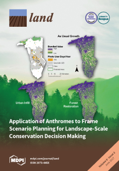
As biodiversity conservation aligns with sustainability science, research and planning efforts need to reflect natural and human systems. Here we show how anthromes are an advantageous framing tool for conservation planning across systems. We used InVEST models to develop and explore LULC scenarios and to measure and bundle (cover figure) variation in biodiversity and ecosystem services in a region where dense settlements are expanding into woodland anthromes. We found that narratives created from anthromes forced stakeholders to articulate more realistic objectives and guided the identification of unanticipated opportunities. Ultimately, the anthrome paradigm allows researchers, planners, and stakeholders to better understand tradeoffs and synergies at landscape scales, which is essential for maintaining benefits for humans and natural systems in complex, rapidly urbanizing areas. View the paper
  • Issues are regarded as officially published after their release is announced to the table of contents alert mailing list.
  • You may sign up for e-mail alerts to receive table of contents of newly released issues.
  • PDF is the official format for papers published in both, html and pdf forms. To view the papers in pdf format, click on the "PDF Full-text" link, and use the free Adobe Reader to open them.
Order results
Result details
Section
Select all
Export citation of selected articles as:
3857 KiB  
Article
From Producers to Consumers: The Challenges and Opportunities of Agricultural Development in Iraqi Kurdistan
by Lina Eklund, Abdulhakim Abdi and Mine Islar
Land 2017, 6(2), 44; https://doi.org/10.3390/land6020044 - 22 Jun 2017
Cited by 11 | Viewed by 10411
Abstract
Agriculture and rural life in the Middle East have gone through several changes in the past few decades. The region is characterized by high population growth, urbanization, and water scarcity, which poses a challenge to maintaining food security and production. This paper investigates [...] Read more.
Agriculture and rural life in the Middle East have gone through several changes in the past few decades. The region is characterized by high population growth, urbanization, and water scarcity, which poses a challenge to maintaining food security and production. This paper investigates agricultural and rural challenges in the Duhok governorate of Iraqi Kurdistan from biophysical, political, and socio-economic perspectives. Satellite data is used to study land use and productivity, while a review of government policies and interview data show the perspectives of the government and the local population. Our results reveal that these perspectives are not necessarily in line with each other, nor do they correspond well with the biophysical possibilities. While the government has been trying to increase agricultural productivity, satellite data show that yields have been declining since 2000. Furthermore, a lack of services in rural areas is driving people to cities to seek better opportunities, which means that the local population’s incentive to increase agricultural activity is low. Governmental plans suggest land extensification to increase production and self-sufficiency, but the land use classification shows little available land. Instead, we recommend supporting small-scale traditional agriculture development as a more sustainable and feasible alternative. Additionally, more resources need to be focused on improving rural infrastructure and services to increase access to education and health care as a means of gaining support from the local population. Full article
Show Figures

Figure 1

5255 KiB  
Article
Numerical Investigation of Aggregated Fuel Spatial Pattern Impacts on Fire Behavior
by Russell A. Parsons, Rodman R. Linn, Francois Pimont, Chad Hoffman, Jeremy Sauer, Judith Winterkamp, Carolyn H. Sieg and W. Matt Jolly
Land 2017, 6(2), 43; https://doi.org/10.3390/land6020043 - 18 Jun 2017
Cited by 44 | Viewed by 6231
Abstract
Landscape heterogeneity shapes species distributions, interactions, and fluctuations. Historically, in dry forest ecosystems, low canopy cover and heterogeneous fuel patterns often moderated disturbances like fire. Over the last century, however, increases in canopy cover and more homogeneous patterns have contributed to altered fire [...] Read more.
Landscape heterogeneity shapes species distributions, interactions, and fluctuations. Historically, in dry forest ecosystems, low canopy cover and heterogeneous fuel patterns often moderated disturbances like fire. Over the last century, however, increases in canopy cover and more homogeneous patterns have contributed to altered fire regimes with higher fire severity. Fire management strategies emphasize increasing within-stand heterogeneity with aggregated fuel patterns to alter potential fire behavior. Yet, little is known about how such patterns may affect fire behavior, or how sensitive fire behavior changes from fuel patterns are to winds and canopy cover. Here, we used a physics-based fire behavior model, FIRETEC, to explore the impacts of spatially aggregated fuel patterns on the mean and variability of stand-level fire behavior, and to test sensitivity of these effects to wind and canopy cover. Qualitative and quantitative approaches suggest that spatial fuel patterns can significantly affect fire behavior. Based on our results we propose three hypotheses: (1) aggregated spatial fuel patterns primarily affect fire behavior by increasing variability; (2) this variability should increase with spatial scale of aggregation; and (3) fire behavior sensitivity to spatial pattern effects should be more pronounced under moderate wind and fuel conditions. Full article
(This article belongs to the Special Issue Wildland Fires)
Show Figures

Figure 1

21761 KiB  
Article
Monitoring Urban Growth and the Nepal Earthquake 2015 for Sustainability of Kathmandu Valley, Nepal
by Bhagawat Rimal, Lifu Zhang, Dongjie Fu, Ripu Kunwar and Yongguang Zhai
Land 2017, 6(2), 42; https://doi.org/10.3390/land6020042 - 17 Jun 2017
Cited by 24 | Viewed by 17335
Abstract
The exodus of people from rural areas to cities brings many detrimental environmental, social and cultural consequences. Monitoring spatiotemporal change by referencing the historical timeline or incidence has become an important way to analyze urbanization. This study has attempted to attain the cross-sectional [...] Read more.
The exodus of people from rural areas to cities brings many detrimental environmental, social and cultural consequences. Monitoring spatiotemporal change by referencing the historical timeline or incidence has become an important way to analyze urbanization. This study has attempted to attain the cross-sectional analysis of Kathmandu valley that has been plagued by rampant urbanization over the last three decades. The research utilizes Landsat images of Kathmandu valley from 1976 to 2015 for the transition analysis of land use, land cover and urban sprawl for the last four decades. Results showed that the urban coverage of Kathmandu valley has tremendously increased from 20.19 km2 in 1976 to 39.47 km2 in 1989 to 78.96 km2 in 2002 to 139.57 km2 in 2015, at the cost of cultivated lands, with an average annual urban growth rate of 7.34%, 7.70% and 5.90% in each temporal interval, respectively. In addition, the urban expansion orientation analysis concludes the significant urban concentration in the eastern part, moderately medium in the southwest and relatively less in the western and northwest part of the valley. Urbanization was solely accountable for the exploitation of extant forests, fertile and arable lands and indigenous and cultural landscapes. Unattended fallow lands in suburban areas have compounded the problem by welcoming invasive alien species. Overlaying the highly affected geological formations within the major city centers displays that unless the trend of rapid, unplanned urbanization is discontinued, the future of Kathmandu is at the high risk. Since land use management is a fundamental part of development, we advocate for the appropriate land use planning and policies for sustainable and secure future development. Full article
(This article belongs to the Special Issue Urban Land Systems: An Ecosystems Perspective)
Show Figures

Figure 1

160 KiB  
Article
Biodiversity in Locally Managed Lands
by Jeffrey Sayer and Chris Margules
Land 2017, 6(2), 41; https://doi.org/10.3390/land6020041 - 15 Jun 2017
Cited by 6 | Viewed by 3839
Abstract
Decentralizing natural resource management to local people, especially in tropical countries, has become a trend. We review recent evidence for the impacts of decentralization on the biodiversity values of forests and forested landscapes, which encompass most of the biodiversity of the tropics. Few [...] Read more.
Decentralizing natural resource management to local people, especially in tropical countries, has become a trend. We review recent evidence for the impacts of decentralization on the biodiversity values of forests and forested landscapes, which encompass most of the biodiversity of the tropics. Few studies document the impact of decentralized management on biodiversity. We conclude that there may be situations where local management is a good option for biodiversity but there are also situations where this is not the case. We advocate increased research to document the impact of local management on biodiversity. We also argue that locally managed forests should be seen as components of landscapes where governance arrangements favor the achievement of a balance between the local livelihood values and the global public goods values of forests. Full article
(This article belongs to the Special Issue Biodiversity in Locally Managed Lands)
6416 KiB  
Article
Landscape Archaeology and Sacred Space in the Eastern Mediterranean: A Glimpse from Cyprus
by Giorgos Papantoniou and Athanasios K. Vionis
Land 2017, 6(2), 40; https://doi.org/10.3390/land6020040 - 14 Jun 2017
Cited by 23 | Viewed by 9109
Abstract
This article aims to raise issues for discussion about the change in the use and concept of sacred landscapes, which were originally constructed in the era of the Cypriot kings (the basileis), but then continued to function in a new imperial environment, [...] Read more.
This article aims to raise issues for discussion about the change in the use and concept of sacred landscapes, which were originally constructed in the era of the Cypriot kings (the basileis), but then continued to function in a new imperial environment, that of the rule of the Ptolemaic strategos and later of the Roman proconsul and the various Christian bishops. Our archaeological survey project in the Xeros river valley, titled ‘Settled and Sacred Landscapes of Cyprus’, reveals that these new politico-economic structures were also supported by the construction of symbolically charged sacred landscapes. Thus, while outlining the long history of the island as manifested from the diachronic study of Cypriot sacred landscapes, we identify three pivotal phases: first, the consolidation of the Cypriot polities and the establishment of a ‘full’ sacred landscape; second, the transition from segmented to unitary administration under the Ptolemaic and Roman imperial rule and the consolidation of a more ‘unified sacred landscape’; and finally, the establishment of a number of Christian bishoprics on the island and the movement back to a ‘full’ sacred landscape. Moving beyond the discipline of Cypriot archaeology, this contribution aims to serve as a paradigm for the implications that the employment of the ‘sacred landscapes’ concept may have when addressing issues of socio-political and socio-economic transformations. While it is very difficult to define or capture the concept of landscape in a pre-modern world, it offers a useful means by which to assess changing local conditions. We have also attempted to situate the term in archaeological thought, in order to allow the concept to become a more powerful investigative tool for approaching the past. Full article
Show Figures

Figure 1

23781 KiB  
Article
Detection of Land Subsidence in Kathmandu Valley, Nepal, Using DInSAR Technique
by Richa Bhattarai, Haireti Alifu, Aikebaier Maitiniyazi and Akihiko Kondoh
Land 2017, 6(2), 39; https://doi.org/10.3390/land6020039 - 11 Jun 2017
Cited by 13 | Viewed by 7815
Abstract
Differential Synthetic Aperture Radar Interferometry (DInSAR) is a remote sensing technique that is capable of detecting land surface deformation with centimeter accuracy. In this research, this technique was applied to two pairs of Advanced Land Observing Satellite (ALOS) Phased Array L-band SAR (PALSAR) [...] Read more.
Differential Synthetic Aperture Radar Interferometry (DInSAR) is a remote sensing technique that is capable of detecting land surface deformation with centimeter accuracy. In this research, this technique was applied to two pairs of Advanced Land Observing Satellite (ALOS) Phased Array L-band SAR (PALSAR) data to detect land subsidence in the Kathmandu valley from 2007 to 2010. The result revealed several subsidence areas towards the center of the valley ranging from a maximum of 9.9 km2 to a minimum of 1 km2 coverage with a maximum velocity of 4.8 cm/year, and a minimum velocity of 1.1 cm/year, respectively. The majority of the subsidence was observed in old settlement areas with mixed use development. The subsidence depth was found to gradually increase from the periphery towards the center in almost all detected subsidence areas. The subsidence depth was found to be in a range of 1 cm to 17 cm. It was found that the concentration of deep water extraction wells was higher in areas with higher subsidence rates. It was also found that the detected subsidence area was situated over geological formations mainly consisting of unconsolidated fine-grained sediments (silica, sand, silt, clay and silty sandy gravel), which is the major factor affecting the occurrence of land subsidence due to groundwater extraction. Full article
Show Figures

Figure 1

242 KiB  
Review
A Review on Remote Sensing of Urban Heat and Cool Islands
by Azad Rasul, Heiko Balzter, Claire Smith, John Remedios, Bashir Adamu, José A. Sobrino, Manat Srivanit and Qihao Weng
Land 2017, 6(2), 38; https://doi.org/10.3390/land6020038 - 09 Jun 2017
Cited by 91 | Viewed by 19253
Abstract
The variation between land surface temperature (LST) within a city and its surrounding area is a result of variations in surface cover, thermal capacity and three-dimensional geometry. The objective of this research is to review the state of knowledge and current research to [...] Read more.
The variation between land surface temperature (LST) within a city and its surrounding area is a result of variations in surface cover, thermal capacity and three-dimensional geometry. The objective of this research is to review the state of knowledge and current research to quantify surface urban heat islands (SUHI) and surface urban cool islands (SUCI). In order to identify open issues and gaps remaining in this field, we review research on SUHI/SUCI, the models for simulating UHIs/UCIs and techniques used in this field were appraised. The appraisal has revealed some great progress made in surface UHI mapping of cities located in humid and vegetated (temperate) regions, whilst few studies have investigated the spatiotemporal variation of surface SUHI/SUCI and the effect of land use/land cover (LULC) change on LST in arid and semi-arid climates. While some progress has been made, models for simulating UHI/UCI have been advancing only slowly. We conclude and suggest that SUHI/SUCI in arid and semi-arid areas requires more in-depth study. Full article
(This article belongs to the Special Issue Urban Land Systems: An Ecosystems Perspective)
794 KiB  
Article
The Status of National Legal Frameworks for Valuing Compensation for Expropriated Land: An Analysis of Whether National Laws in 50 Countries/Regions across Asia, Africa, and Latin America Comply with International Standards on Compensation Valuation
by Nicholas K. Tagliarino
Land 2017, 6(2), 37; https://doi.org/10.3390/land6020037 - 01 Jun 2017
Cited by 22 | Viewed by 17366
Abstract
The challenges associated with determining fair compensation for expropriated land have been extensively discussed and debated among scholars, practitioners, policymakers, and the public. However, to date, a comprehensive study of national-level compensation procedures established by law considering whether such procedures meet internationally recognized [...] Read more.
The challenges associated with determining fair compensation for expropriated land have been extensively discussed and debated among scholars, practitioners, policymakers, and the public. However, to date, a comprehensive study of national-level compensation procedures established by law considering whether such procedures meet internationally recognized standards on compensation valuation has not been conducted. This article aims to bridge this gap by serving as a reference point and informing “fair compensation” debates among scholars, practitioners, and policymakers. This article examines national-level legal provisions on compensation in 50 countries/regions across Asia, Africa, and Latin America against a set of legal indicators that are based on international standards on the valuation of compensation. The legal indicators focus on the substantive and procedural requirements pertaining to the calculation of compensation. The indicators ask whether laws require assessors to account for various land values when calculating compensation, and whether there are legal processes in place that allow affected persons to negotiate compensation amounts, receive prompt payments, and hold governments accountable by appealing compensation decisions in courts or before tribunals. The results of the study show that most of the 50 countries/regions assessed do not have national laws that comply with internationally recognized standards on the valuation of compensation. Based on the findings from the legal indicator analysis, this paper presents a set of recommendations for reforming compensation procedures to bring them into conformity with international standards. Full article
(This article belongs to the Special Issue Land, Environment, and Policy)
Show Figures

Figure 1

3876 KiB  
Article
Modeling Future Land Cover Changes and Their Effects on the Land Surface Temperatures in the Saudi Arabian Eastern Coastal City of Dammam
by Muhammad Tauhidur Rahman, Adel S. Aldosary and Md. Golam Mortoja
Land 2017, 6(2), 36; https://doi.org/10.3390/land6020036 - 29 May 2017
Cited by 73 | Viewed by 11249
Abstract
Over the past several decades, Saudi cities have experienced rapid urban developments and land use and land cover (LULC) changes. These developments will have numerous short- and long-term consequences including increasing the land surface temperature (LST) of these cities. This study investigated the [...] Read more.
Over the past several decades, Saudi cities have experienced rapid urban developments and land use and land cover (LULC) changes. These developments will have numerous short- and long-term consequences including increasing the land surface temperature (LST) of these cities. This study investigated the effects of LULC changes on the LST for the eastern coastal city of Dammam. Using Landsat imagery, the study first detected the LULC using the maximum likelihood classification method and derived the LSTs for the years 1990, 2002, and 2014. Using the classified results, it then modeled the future LULC for 2026 using the Cellular Automata Markov (CAM) model. Finally, using three thematic indices and linear regression analysis, it then modeled the LST for 2026 as well. The built-up area in Dammam increased by 28.9% between 1990 and 2014. During this period, the average LSTs for the LULC classes increased as well, with bare soil and built-up area having the highest LST. By 2026, the urban area is expected to encompass 55% of the city and 98% of the land cover is envisioned to have average LSTs over 41 °C. Such high temperatures will make it difficult for the residents to live in the area. Full article
(This article belongs to the Special Issue Urban Land Systems: An Ecosystems Perspective)
Show Figures

Figure 1

39501 KiB  
Article
Quantifying the National Significance of Local Areas for Regional Conservation Planning: North Carolina’s Mountain Treasures
by R. Travis Belote and G. Hugh Irwin
Land 2017, 6(2), 35; https://doi.org/10.3390/land6020035 - 27 May 2017
Cited by 3 | Viewed by 6589
Abstract
Conservation scientists recognize that additional protected areas are needed to maintain biological diversity and ecological processes. As regional conservation planners embark on recommending additional areas for protection in formal ecological reserves, it is important to evaluate candidate lands for their role in building [...] Read more.
Conservation scientists recognize that additional protected areas are needed to maintain biological diversity and ecological processes. As regional conservation planners embark on recommending additional areas for protection in formal ecological reserves, it is important to evaluate candidate lands for their role in building a resilient protected areas system of the future. Here, we evaluate North Carolina’s Mountain Treasures with respect to their (1) ecological integrity, (2) role in connecting existing core protected areas, (3) potential to diversify the ecosystem representation of reserves, and (4) role in maintaining hotspots of biologically-rich areas that are not well protected. Mountain Treasures represent a citizen inventory of roadless areas and serve as candidates for elevated levels of conservation protection on U.S. federal lands. We compared Mountain Treasures to other candidate lands throughout the country to evaluate their potential national significance. While the Mountain Treasures tended to be more impacted by human modifications than other roadless areas, they are as important as other roadless areas with respect to their role in connecting existing protected areas and diversifying representation of ecosystems in conservation reserves. However, Mountain Treasures tended to have a much higher biodiversity priority index than other roadless areas leading to an overall higher composite score compared to other roadless areas. Our analysis serves as an example of how using broad-scale datasets can help conservation planners assess the national significance of local areas. Full article
Show Figures

Figure 1

2120 KiB  
Article
Validation and Inter-Comparison of Spaceborne Derived Global and Continental Land Cover Products for the Mediterranean Region: The Case of Thessaly
by Ioannis Manakos, Christina Karakizi, Ioannis Gkinis and Konstantinos Karantzalos
Land 2017, 6(2), 34; https://doi.org/10.3390/land6020034 - 12 May 2017
Cited by 10 | Viewed by 5229
Abstract
Space agencies, international and national organisations and institutions recognize the importance of regularly updated and homogenized land cover information, in the context of both nomenclature and spatial resolution. Moreover, ensuring credibility to the users through validated products with transparent procedures is similarly of [...] Read more.
Space agencies, international and national organisations and institutions recognize the importance of regularly updated and homogenized land cover information, in the context of both nomenclature and spatial resolution. Moreover, ensuring credibility to the users through validated products with transparent procedures is similarly of great importance. To this end, this study contributes with a systematic accuracy performance evaluation of continental and global land cover layers. Confidence levels during validation and a weighted accuracy assessment were designed and applied. Google Earth imagery were employed to assess the accuracy of three land cover products for the years 2010 and 2012. Results indicate high weighted overall accuracy rates of 89, 90, and 86% for CORINE Land Cover 2012, GIO High Resolution Layers, and Globeland30 datasets, respectively. Moreover, their inter-comparison highlights notable differences especially for classes Artificial Surfaces and Water. The deviation of specific classes from the general producer’s and user’s accuracy trends were identified. It is concluded that the different aspects of the employed land cover products can be highlighted more transparently and objectively by integrating confidence levels during the reference data annotation, by employing a stratified sampling based on the several Corine Level-3 subclasses and by applying a weighted overall accuracy procedure. Full article
Show Figures

Graphical abstract

8844 KiB  
Article
Application of Anthromes to Frame Scenario Planning for Landscape-Scale Conservation Decision Making
by Dainee M. Gibson and John E. Quinn
Land 2017, 6(2), 33; https://doi.org/10.3390/land6020033 - 10 May 2017
Cited by 22 | Viewed by 8003
Abstract
Complexities in the rates and patterns of change necessitate the consideration of alternate futures in planning processes. These scenarios, and the inputs and assumptions used to build them, should reflect both ecological and social contexts. Considering the regional landscape as an anthrome, a [...] Read more.
Complexities in the rates and patterns of change necessitate the consideration of alternate futures in planning processes. These scenarios, and the inputs and assumptions used to build them, should reflect both ecological and social contexts. Considering the regional landscape as an anthrome, a priori, assumes human needs and institutions have a fundamental role and place in these futures, but that institutions incorporate ecological limits in decision making. As a case study of conservation scenario planning under the anthrome paradigm, we used a suite of InVEST models to develop and explore land use and land cover scenarios and to measure the associated change in biodiversity and ecosystem services in a region where dense settlements are expanding into populated and residential woodland anthromes. While tradeoffs between benefits in alternative futures are unavoidable, we found that distinct conservation opportunities arise within and around the protected areas and in the heterogeneous urban core of the county. Reflecting on the process and subsequent findings, we discuss why anthromes can be a more suitable framing for scenarios used in conservation decision making and land use planning. Specifically, we discuss how starting with anthromes influenced assumptions about inputs and opportunities and the decisions related to the planning for human and natural systems. Full article
(This article belongs to the Special Issue Anthropogenic Biomes)
Show Figures

Figure 1

7034 KiB  
Article
Historical Land Use Dynamics in the Highly Degraded Landscape of the Calhoun Critical Zone Observatory
by Michael R. Coughlan, Donald R. Nelson, Michael Lonneman and Ashley E. Block
Land 2017, 6(2), 32; https://doi.org/10.3390/land6020032 - 02 May 2017
Cited by 21 | Viewed by 6849
Abstract
Processes of land degradation and regeneration display fine scale heterogeneity often intimately linked with land use. Yet, examinations of the relationships between land use and land degradation often lack the resolution necessary to understand how local institutions differentially modulate feedback between individual farmers [...] Read more.
Processes of land degradation and regeneration display fine scale heterogeneity often intimately linked with land use. Yet, examinations of the relationships between land use and land degradation often lack the resolution necessary to understand how local institutions differentially modulate feedback between individual farmers and the spatially heterogeneous effects of land use on soils. In this paper, we examine an historical example of a transition from agriculture to forest dominated land use (c. 1933–1941) in a highly degraded landscape on the Piedmont of South Carolina. Our landscape-scale approach examines land use and tenure at the level that individuals enact management decisions. We used logistic regression techniques to examine associations between land use, land tenure, topography, and market cost-distance. Our findings suggest that farmer responses to changing market and policy conditions were influenced by topographic characteristics associated with productivity and long-term viability of agricultural land use. Further, although local environmental feedbacks help to explain spatial patterning of land use, property regime and land tenure arrangements also significantly constrained the ability of farmers to adapt to changing socioeconomic and environmental conditions. Full article
Show Figures

Figure 1

1276 KiB  
Article
Rangelands: Where Anthromes Meet Their Limits
by Nathan F. Sayre, Diana K. Davis, Brandon Bestelmeyer and Jeb C. Williamson
Land 2017, 6(2), 31; https://doi.org/10.3390/land6020031 - 01 May 2017
Cited by 35 | Viewed by 9085
Abstract
Defining rangelands as anthromes enabled Ellis and Ramankutty (2008) to conclude that more than three-quarters of Earth’s land is anthropogenic; without rangelands, this figure would have been less than half. They classified all lands grazed by domestic livestock as rangelands, provided that human [...] Read more.
Defining rangelands as anthromes enabled Ellis and Ramankutty (2008) to conclude that more than three-quarters of Earth’s land is anthropogenic; without rangelands, this figure would have been less than half. They classified all lands grazed by domestic livestock as rangelands, provided that human population densities were low; similar areas without livestock were excluded and classified instead as ‘wildlands’. This paper examines the empirical basis and conceptual assumptions of defining and categorizing rangelands in this fashion. Empirically, we conclude that a large proportion of rangelands, although used to varying degrees by domesticated livestock, are not altered significantly by this use, especially in arid, highly variable environments and in settings with long evolutionary histories of herbivory by wild animals. Even where changes have occurred, the dynamics and components of many rangelands remain structurally and functionally equivalent to those that preceded domestic livestock grazing or would be found in its absence. In much of Africa and Asia, grazing is so longstanding as to be inextricable from ‘natural’ or reference conditions for those sites. Thus, the extent of anthropogenic biomes is significantly overstated. Conceptually, rangelands reveal the dependence of the anthromes thesis on outdated assumptions of ecological climax and equilibrium. Coming to terms with rangelands—how they can be classified, understood, and managed sustainably—thus offers important lessons for understanding anthromes and the Anthropocene as a whole. At the root of these lessons, we argue, is not the question of human impacts on ecosystems but property relations among humans. Full article
(This article belongs to the Special Issue Anthropogenic Biomes)
Show Figures

Graphical abstract

4608 KiB  
Article
Spatial and Temporal Characteristics of Road Networks and Urban Expansion
by Guoliang Zhao, Xinqi Zheng, Zhiyuan Yuan and Lulu Zhang
Land 2017, 6(2), 30; https://doi.org/10.3390/land6020030 - 28 Apr 2017
Cited by 30 | Viewed by 7782
Abstract
Urban expansion has become a widespread trend in developing countries. Road networks are an extremely important factor driving the expansion of urban land and require further study. To investigate the relationship between road networks and urban expansion, we selected Beijing, New York, London, [...] Read more.
Urban expansion has become a widespread trend in developing countries. Road networks are an extremely important factor driving the expansion of urban land and require further study. To investigate the relationship between road networks and urban expansion, we selected Beijing, New York, London, and Chicago as study areas. First, we obtained urban land use vector data through image interpretation using a remote sensing (RS) and geographic information systems (GIS) platform and then used overlay analysis to extract information on urban expansion. A road network density map was generated using the density analysis tool. Finally, we conducted a spatial statistical analysis between road networks and urban expansion and then systematically analyzed their distribution features. In addition, the Urban Expansion-Road Network Density Model was established based on regression analysis. The results indicate that (1) the road network density thresholds of Beijing, New York, London, and Chicago are 18.9 km/km2, 37.8 km/km2, 57.0 km/km2, and 64.7 km/km2, respectively, and urban expansion has an inverted U-curve relationship with road networks when the road network density does not exceed the threshold; (2) the calculated turning points for urban expansion indicate that urban expansion initially accelerates with increasing road network density but then decreases after the turning point is reached; and (3) when the road density exceeds the threshold, urban areas cease to expand. The correlation between urban expansion and road network features provides an important reference for the future development of global cities. Understanding road network density offers some predictive capabilities for urban land expansion, facilitates the avoidance of irregular expansion, and provides new ideas for addressing the inefficient utilization of land. Full article
(This article belongs to the Special Issue Land, Environment, and Policy)
Show Figures

Figure 1

13133 KiB  
Article
Historical Analysis of Riparian Vegetation Change in Response to Shifting Management Objectives on the Middle Rio Grande
by Roy E. Petrakis, Willem J.D. Van Leeuwen, Miguel L. Villarreal, Paul Tashjian, Regina Dello Russo and Christopher A. Scott
Land 2017, 6(2), 29; https://doi.org/10.3390/land6020029 - 22 Apr 2017
Cited by 11 | Viewed by 7599
Abstract
Riparian ecosystems are valuable to the ecological and human communities that depend on them. Over the past century, they have been subject to shifting management practices to maximize human use and ecosystem services, creating a complex relationship between water policy, management, and the [...] Read more.
Riparian ecosystems are valuable to the ecological and human communities that depend on them. Over the past century, they have been subject to shifting management practices to maximize human use and ecosystem services, creating a complex relationship between water policy, management, and the natural ecosystem. This has necessitated research on the spatial and temporal dynamics of riparian vegetation change. The San Acacia Reach of the Middle Rio Grande has experienced multiple management and river flow fluctuations, resulting in threats to its riparian and aquatic ecosystems. This research uses remote sensing data, GIS, a review of management decisions, and an assessment of climate to both quantify how riparian vegetation has been altered over time and provide interpretations of the relationships between riparian change and shifting climate and management objectives. This research focused on four management phases from 1935 to 2014, each highlighting different management practices and climate-driven river patterns, providing unique opportunities to observe a direct relationship between river management, climate, and riparian response. Overall, we believe that management practices coupled with reduced surface river-flows with limited overbank flooding influenced the compositional and spatial patterns of vegetation, including possibly increasing non-native vegetation coverage. However, recent restoration efforts have begun to reduce non-native vegetation coverage. Full article
Show Figures

Graphical abstract

2229 KiB  
Article
Agricultural Land Fragmentation at Urban Fringes: An Application of Urban-To-Rural Gradient Analysis in Adelaide
by Suranga Wadduwage, Andrew Millington, Neville D. Crossman and Harpinder Sandhu
Land 2017, 6(2), 28; https://doi.org/10.3390/land6020028 - 16 Apr 2017
Cited by 41 | Viewed by 8910
Abstract
One of the major consequences of expansive urban growth is the degradation and loss of productive agricultural land and agroecosystem functions. Four landscape metrics—Percentage of Land (PLAND), Mean Parcel Size (MPS), Parcel Density (PD), and Modified Simpson’s Diversity Index (MSDI)—were calculated for 1 [...] Read more.
One of the major consequences of expansive urban growth is the degradation and loss of productive agricultural land and agroecosystem functions. Four landscape metrics—Percentage of Land (PLAND), Mean Parcel Size (MPS), Parcel Density (PD), and Modified Simpson’s Diversity Index (MSDI)—were calculated for 1 km × 1 km cells along three 50 km-long transects that extend out from the Adelaide CBD, in order to analyze variations in landscape structures. Each transect has different land uses beyond the built-up area, and they differ in topography, soils, and rates of urban expansion. Our new findings are that zones of agricultural land fragmentation can be identified by the relationships between MPS and PD, that these occur in areas where PD ranges from 7 and 35, and that these occur regardless of distance along the transect, land use, topography, soils, or rates of urban growth. This suggests a geometry of fragmentation that may be consistent, and indicates that quantification of both land use and land-use change in zones of fragmentation is potentially important in planning. Full article
(This article belongs to the Special Issue Urban Land Systems: An Ecosystems Perspective)
Show Figures

Figure 1

5003 KiB  
Article
Factors Influencing Perceptions and Use of Urban Nature: Surveys of Park Visitors in Delhi
by Somajita Paul and Harini Nagendra
Land 2017, 6(2), 27; https://doi.org/10.3390/land6020027 - 16 Apr 2017
Cited by 61 | Viewed by 10425
Abstract
Urban green spaces provide important recreational, social and psychological benefits to stressed city residents. This paper aims to understand the importance of parks for visitors. We focus on Delhi, the world’s second most populous city, drawing on 123 interviews with park visitors in [...] Read more.
Urban green spaces provide important recreational, social and psychological benefits to stressed city residents. This paper aims to understand the importance of parks for visitors. We focus on Delhi, the world’s second most populous city, drawing on 123 interviews with park visitors in four prominent city parks. Almost all respondents expressed the need for more green spaces. Visitors valued parks primarily for environmental and psychological/health benefits. They had limited awareness of biodiversity, with one out of three visitors unable to identify tree species and one out of four visitors unable to identify animal species frequenting the park. Most of the daily visitors lived within 0.5 km of these parks, but a small fraction of visitors traveled over 10 km to visit these major parks, despite having smaller neighbourhood parks in their vicinity. This study demonstrates the importance of large, well-maintained, publicly accessible parks in a crowded city. The results can help to better plan and design urban green spaces, responding to the needs and preferences of urban communities. This research contributes to the severely limited information on people’s perceptions of and requirements from urban nature in cities of the Global South. Full article
(This article belongs to the Special Issue Urban Land Systems: An Ecosystems Perspective)
Show Figures

Figure 1

9861 KiB  
Article
Modeling Future Urban Sprawl and Landscape Change in the Laguna de Bay Area, Philippines
by Kotaro Iizuka, Brian A. Johnson, Akio Onishi, Damasa B. Magcale-Macandog, Isao Endo and Milben Bragais
Land 2017, 6(2), 26; https://doi.org/10.3390/land6020026 - 14 Apr 2017
Cited by 36 | Viewed by 14665
Abstract
This study uses a spatially-explicit land-use/land-cover (LULC) modeling approach to model and map the future (2016–2030) LULC of the area surrounding the Laguna de Bay of Philippines under three different scenarios: ‘business-as-usual’, ‘compact development’, and ‘high sprawl’ scenarios. The Laguna de Bay is [...] Read more.
This study uses a spatially-explicit land-use/land-cover (LULC) modeling approach to model and map the future (2016–2030) LULC of the area surrounding the Laguna de Bay of Philippines under three different scenarios: ‘business-as-usual’, ‘compact development’, and ‘high sprawl’ scenarios. The Laguna de Bay is the largest lake in the Philippines and an important natural resource for the population in/around Metro Manila. The LULC around the lake is rapidly changing due to urban sprawl, so local and national government agencies situated in the area need an understanding of the future (likely) LULC changes and their associated hydrological impacts. The spatial modeling approach involved three main steps: (1) mapping the locations of past LULC changes; (2) identifying the drivers of these past changes; and (3) identifying where and when future LULC changes are likely to occur. Utilizing various publically-available spatial datasets representing potential drivers of LULC changes, a LULC change model was calibrated using the Multilayer Perceptron (MLP) neural network algorithm. After calibrating the model, future LULC changes were modeled and mapped up to the year 2030. Our modeling results showed that the ‘built-up’ LULC class is likely to experience the greatest increase in land area due to losses in ‘crop/grass’ (and to a lesser degree ‘tree’) LULC, and this is attributed to continued urban sprawl. Full article
(This article belongs to the Special Issue Urban Land Systems: An Ecosystems Perspective)
Show Figures

Figure 1

13379 KiB  
Article
Analysis of Urban Green Spaces Based on Sentinel-2A: Case Studies from Slovakia
by Monika Kopecká, Daniel Szatmári and Konštantín Rosina
Land 2017, 6(2), 25; https://doi.org/10.3390/land6020025 - 14 Apr 2017
Cited by 53 | Viewed by 10638
Abstract
Urban expansion and its ecological footprint increases globally at an unprecedented scale and consequently, the importance of urban greenery assessment grows. The diversity and quality of urban green spaces (UGS) and human well-being are tightly linked, and UGS provide a wide range of [...] Read more.
Urban expansion and its ecological footprint increases globally at an unprecedented scale and consequently, the importance of urban greenery assessment grows. The diversity and quality of urban green spaces (UGS) and human well-being are tightly linked, and UGS provide a wide range of ecosystem services (e.g., urban heat mitigation, stormwater infiltration, food security, physical recreation). Analyses and inter-city comparison of UGS patterns and their functions requires not only detailed information on their relative quantity but also a closer examination of UGS in terms of quality and land use, which can be derived from the land cover composition and spatial structure. In this study, we present an approach to UGS extraction from newly available Sentinel-2A satellite imagery, provided in the frame of the European Copernicus program. We investigate and map the spatial distribution of UGS in three cities in Slovakia: Bratislava, Žilina and Trnava. Supervised maximum likelihood classification was used to identify UGS polygons. Based on their function and physiognomy, each UGS polygon was assigned to one of the fifteen classes, and each class was further described by the proportion of tree canopy and its ecosystem services. Our results document that the substantial part of UGS is covered by the class Urban greenery in family housing areas (mainly including privately-owned gardens) with the class abundance between 17.7% and 42.2% of the total UGS area. The presented case studies showed the possibilities of semi-automatic extraction of UGS classes from Sentinel-2A data that may improve the transfer of scientific knowledge to local urban environmental monitoring and management. Full article
(This article belongs to the Special Issue Urban Land Systems: An Ecosystems Perspective)
Show Figures

Graphical abstract

5869 KiB  
Article
Governance of Land Use Planning to Reduce Fire Risk to Homes Mediterranean France and California
by Susan D. Kocher and Van Butsic
Land 2017, 6(2), 24; https://doi.org/10.3390/land6020024 - 31 Mar 2017
Cited by 25 | Viewed by 11384
Abstract
Wildfire is a natural part of forested Mediterranean systems. As humans continue to live and build housing in these areas, wildfire is a constant threat to homes and lives. The goal of this paper is to describe aspects of land-use planning that are [...] Read more.
Wildfire is a natural part of forested Mediterranean systems. As humans continue to live and build housing in these areas, wildfire is a constant threat to homes and lives. The goal of this paper is to describe aspects of land-use planning that are used to reduce wildfire risk in institutionally divergent regions; southern France and California. By reviewing relevant legislation and planning documents and conducting in person interviews with fire and planning professionals, we identify the institutions which participate in land use planning to reduce fire risk and the key laws and regulations that guide planning decisions. Our results indicate that France has a more centralized system for planning for fire, with national level entities heavily involved in local land use planning. California, on the other hand sees almost no federal oversite, and, while state law requires local plans to include wildfire risk, most fine grain decisions are left to local planners and decision makers. In both regions, however, we see a reliance on technical support provided from outside local jurisdictions. Increased coordination between local, regional, and national governments could improve land use planning in both locations. Full article
(This article belongs to the Special Issue Wildland Fires)
Show Figures

Figure 1

1956 KiB  
Article
Forest Cover Changes in Lao Tropical Forests: Physical and Socio-Economic Factors are the Most Important Drivers
by Chittana Phompila, Megan Lewis, Bertram Ostendorf and Kenneth Clarke
Land 2017, 6(2), 23; https://doi.org/10.3390/land6020023 - 28 Mar 2017
Cited by 31 | Viewed by 10061
Abstract
Lao People’s Democratic Republic (PDR) has been experiencing significant forest depletion since the 1980s, but there is little evidence to demonstrate the major causes and underlying drivers for the forest cover changes. In this study, we investigated the relationship between forest cover decrease [...] Read more.
Lao People’s Democratic Republic (PDR) has been experiencing significant forest depletion since the 1980s, but there is little evidence to demonstrate the major causes and underlying drivers for the forest cover changes. In this study, we investigated the relationship between forest cover decrease and increase in the south of Lao PDR between 2006 and 2012 and selected physical and socio-economic factors. We used a map of forest cover changes derived from analysis of Landsat ETM+ imagery in 2006 and 2012, together with socio-economic and physical environmental data from the national authorities. The study area has experienced noticeable forest cover changes: both forest decreases and increases were unevenly distributed throughout the region. Logistic regression models were used to test relationships between forest cover decrease or increase and selected physical and socio-economic factors. Forest clearance was associated strongly with elevation, distance to main roads and shifting cultivation practices. Meanwhile, forest cover increase was more likely to correlate with rubber plantations. Native forest and shifting cultivation lands were vulnerable to being converted into rubber plantations. This research provides much-needed information on which to base forestry policy and decision making to minimize and prevent current deforestation, as well as manage potential risks in the future. Full article
Show Figures

Figure 1

202 KiB  
Article
Do Community-Managed Forests Work? A Biodiversity Perspective
by John Terborgh and Carlos A. Peres
Land 2017, 6(2), 22; https://doi.org/10.3390/land6020022 - 27 Mar 2017
Cited by 26 | Viewed by 13293
Abstract
Community-managed reserves (CMRs) comprise the fastest-growing category of protected areas throughout the tropics. CMRs represent a compromise between advocates of nature conservation and advocates of human development. We ask whether CMRs succeed in achieving the goals of either. A fixed reserve area can [...] Read more.
Community-managed reserves (CMRs) comprise the fastest-growing category of protected areas throughout the tropics. CMRs represent a compromise between advocates of nature conservation and advocates of human development. We ask whether CMRs succeed in achieving the goals of either. A fixed reserve area can produce only a finite resource supply, whereas human populations exploiting them tend to expand rapidly while adopting high-impact technologies to satisfy rising aspirations. Intentions behind the establishment of CMRs may be admirable, but represent an ideal rarely achieved. People tied to the natural forest subsist on income levels that are among the lowest in the Amazon. Limits of sustainable harvesting are often low and rarely known prior to reserve creation or respected thereafter, and resource exhaustion predictably follows. Unintended consequences typically emerge, such as overhunting of the seed dispersers, pollinators, and other animals that provide services essential to perpetuating the forest. CMRs are a low priority for governments, so mostly operate without enforcement, a laxity that encourages illegal forest conversion. Finally, the pull of markets can alter the “business plan” of a reserve overnight, as inhabitants switch to new activities. The reality is that we live in a hyperdynamic world of accelerating change in which past assumptions must continually be re-evaluated. Full article
(This article belongs to the Special Issue Biodiversity in Locally Managed Lands)
Previous Issue
Next Issue
Back to TopTop