2. Materials and Methods: Survey, Historical Cartography and GIS
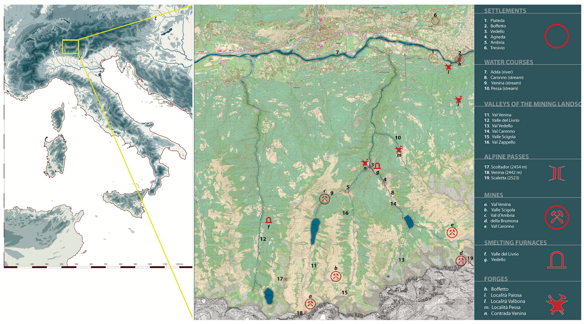
The research activities of the Department of Historical Studies of the University of Turin focused on the territory of the municipalities of Piateda and Fusine, in central Lombardy (N Italy) (
Figure 1), where an accurate graphic and photographic documentation of what remains of this extraordinary remote past in Ambria in Val Venina (Piateda) and in the Cervia and Madre (Fusine) valleys was carried out. The first phase of the research, dedicated to reconnaissance and a preliminary consultation of sources, revealed the absence of the investigated sites in contemporary cartography, which is why the working group’s first objective was to survey and georeference the individual items of evidence.
The specific contexts did not provide fiducial or reference points through a common indirect survey with a total station could be implemented: the results would have been recorded but there would have been no possibility of contextualising them. The total station, moreover, being composed of heavy elements and very sensitive to abrupt movements, would not have been suitable for the type of route that had to be taken on foot, off-path, to reach the places in question; the risk of surveying with an uncalibrated instrument would have been too high.
Having assessed these impossibilities, the only way to carry out an indirect, georeferenced survey was to use a GPS (Navigation Satellites Timing and Ranging Global Positioning System) satellite positioning system, which, through a dedicated network of orbiting artificial satellites, provides a mobile terminal with information on its geographical coordinates. The terminal is placed on the individual points to be surveyed, obtaining their x-y-z coordinates; these data are then graphically transformed into points in space that together delineate the morphology of the survey object. This proposal, too, encountered an obstacle of no small magnitude at an early stage of analysis: the areas concerned are completely lacking in GSM (Global System for Mobile Communications) coverage, a system that is used by the instrument to increase the accuracy of the satellite data received, in the absence of which there can be a very high degree of reliability discrepancy. The solution was found by opting for a type of GPS instrument that bridged the lack of GSM coverage with the help of two receivers, called Base and Rover. Through this system it was possible to proceed with an RTK (Real Time Kinematic mode)-type survey, determining and displaying in real time and in rapid succession the x-y-z coordinates of many points (detailed survey). The Rover station on a pole was placed on the points to be surveyed, connected to the satellite system and linked via Bluetooth to the Base station; the latter, positioned on a point of known coordinates (known point), refined the data from the same satellites. In this way, accuracies of up to half a centimeter were achieved. The size of the constituent elements of the GPS instrument made it possible to transport them easily and to survey all the evidence found in both Fusine (Val Cervia-Val Madre) and Piateda (Ambria-Val Venina).
The Vitalengo mine, in the locality of Flere (Val Cervia), was surveyed precisely along its entire section, providing a graphic elaboration aimed at highlighting the relationship between mining activity and the orography of the terrain. The careful survey made it possible to geolocate and describe the remains of a masonry structure functional to the mining area and two roasting ovens located in the area, providing archaeologists with orthogonal projections and sections useful for analysis and comparison. A few hundred metres from the Vitalengo context, the remains of partially collapsed buildings were identified, which can be considered miners’ dwellings and/or the shelter of animals/work tools, along with an additional roasting oven with adjacent masonry structures.
In Ambria, in the locality of Le Gere, at the foot of the Scale di Venina path, an oven was identified that was reported on some historical maps, though its existence was unknown in the present day. The structure, probably a roasting oven, was geolocated and only partially surveyed due to the presence of invasive vegetation.
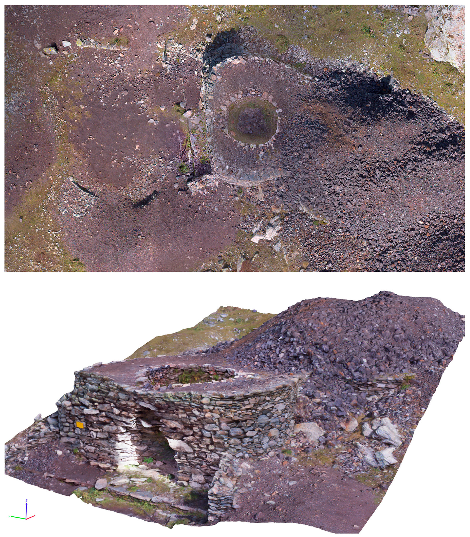
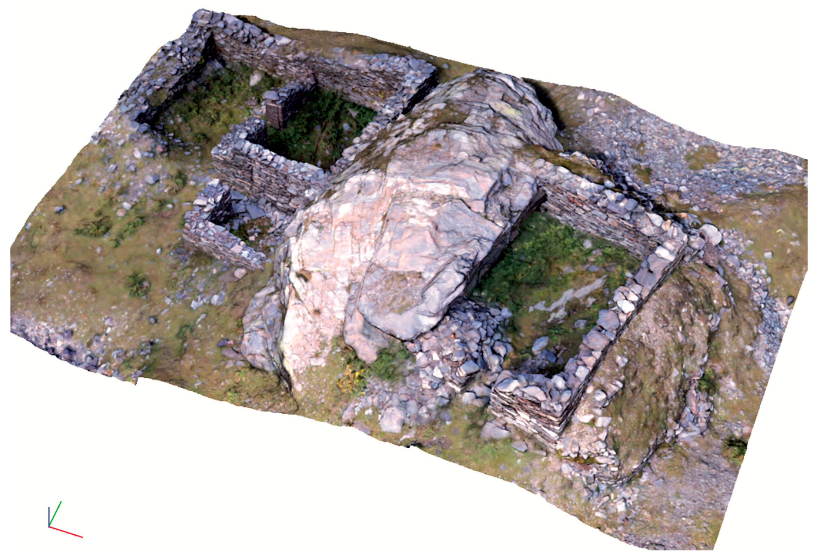
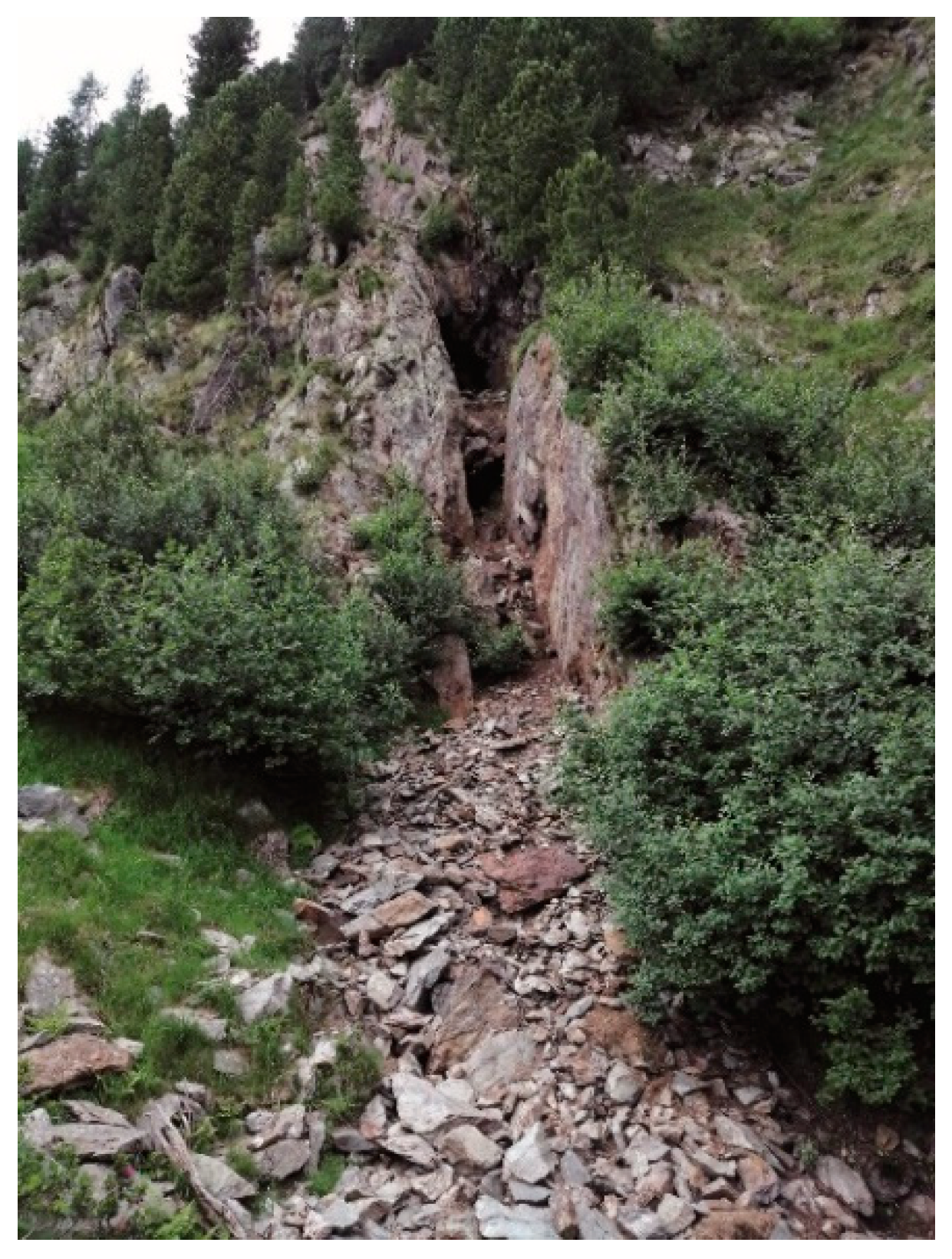
Subsequently, the known evidence forming part of the Val Venina mining site was surveyed, in particular the imposing circular structure (a roasting oven) positioned at the base of the production context, the mouth of an underground tunnel (with a masonry access corridor in front) and the remains of structures attributable to miners’ dwellings and/or the shelter of animals/work tools (
Figure 2).
It is necessary to point out that, given the particular context, the survey activities were preceded by a careful reconnaissance campaign supported by multidisciplinary expertise and geared towards the identification of the survey priorities. Data acquisition was completed by means of aerophotogrammetry, and the GPS tool was used to georeference the drone footage during this phase as well. The first part of this operation was dedicated to planning; the areas to be surveyed were identified, the drone’s take-off and landing points were chosen (a not insignificant detail given the orography), the best positions of the ground control stations were defined, and possible flight obstacles were identified. Teamwork between the aerophotogrammetric survey operator, the survey architect and the archaeologist was necessary to agree on the positioning of the GCPs (Ground Control Points), i.e., the points on the ground whose geographical coordinates were precisely known and which were used to scale the aerophotogrammetric survey. These points, being 60 × 60 cm panels, are fundamental for the aerophotogrammetric survey operator but, if located too close to the archaeological evidence, they risk interfering with the reading of the structures, thereby undermining the purpose for which this operation is carried out. The photographs were taken both with a nadiral camera (pointed towards the ground) and with a camera oriented frontally or inclined with respect to the horizon, in order to subsequently enable a three-dimensional rendering and thus to describe the relationship of the structures with the landscape context (
Figure 1). The meticulous fieldwork made it possible to gather important and unpublished information on the state of the sites at altitude, but it was essential to supplement this with precise cartographic research in order to bring out the historical identity of the sites surveyed and the points of contact with the historical-urban analysis of the centres in which the activity of the forges took place.
The study of historical cartography was undertaken on the basis of the work carried out on the occasion of the exhibition held in Sondrio in 2006 [
6] and Oscar Sceffer’s research, aimed at outlining the cartographic landscape of Rhaetia between the 16th and 19th centuries [
7]. It is important to point out that map publishing developed as a consequence of the start of printing between the end of the 15th century and the beginning of the following century and that the first regional maps date back to the 16th century, a period to which the maps of Valtellina can also be attributed.
In early 17th century cartographic documentation from the Graubünden period, it was possible to find the location of Vitalengo and Venina in the “terzero di mezzo” and the indication of the Alpine passes connecting Val Madre, Val Cervia and Val Venina with the Valle Brembana in the Bergamo area [
8]. The 19th century cartography identified the sites of La Calera in Val Venina, the Forno di Vedello (whose structure was later incorporated into a building, brought to light by the alluvial flood of the Caronno torrent in 1987) and, as described above, the structure of initial material processing in Ambria, in the locality of Le Gere. The research found elements for more in-depth analysis thanks to the study of the 19th century Catasto Lombardo Veneto (Lombardy-Venetia land register), preserved in the State Archives of Milan (first draft of 1815) and Sondrio (second draft of 1853 and subsequent amendments). The collections consist of hundreds of watercolour cadastral maps at a scale of 1:2000 of high formal quality: the “Book of Parcels”, the “Register of Possessors”, the “Register of Map Numbers” and the “Description and Estimate Table”. This census activity was undertaken in Valtellina in 1807; after the fall of Napoleon I, the operations were continued by the succeeding Habsburg government and concluded in 1853. The Catasto Lombardo Veneto is of the geometric parcel type in that it subdivides the territory into parcels defined on the map, classifying them according to pre-established criteria that take into account the intended use, types of cultivation and the value of land and buildings [
9]. The study of this census tool made it possible to identify the forges present in the 19th century in the territory of Fusine and Piateda, where iron was transformed into finished products; by means of cartographic filtering operations with a GIS software, again starting from the Catasto Lombardo Veneto, the study of the system of irrigation ditches that supplied mechanical energy to the activities was further investigated.
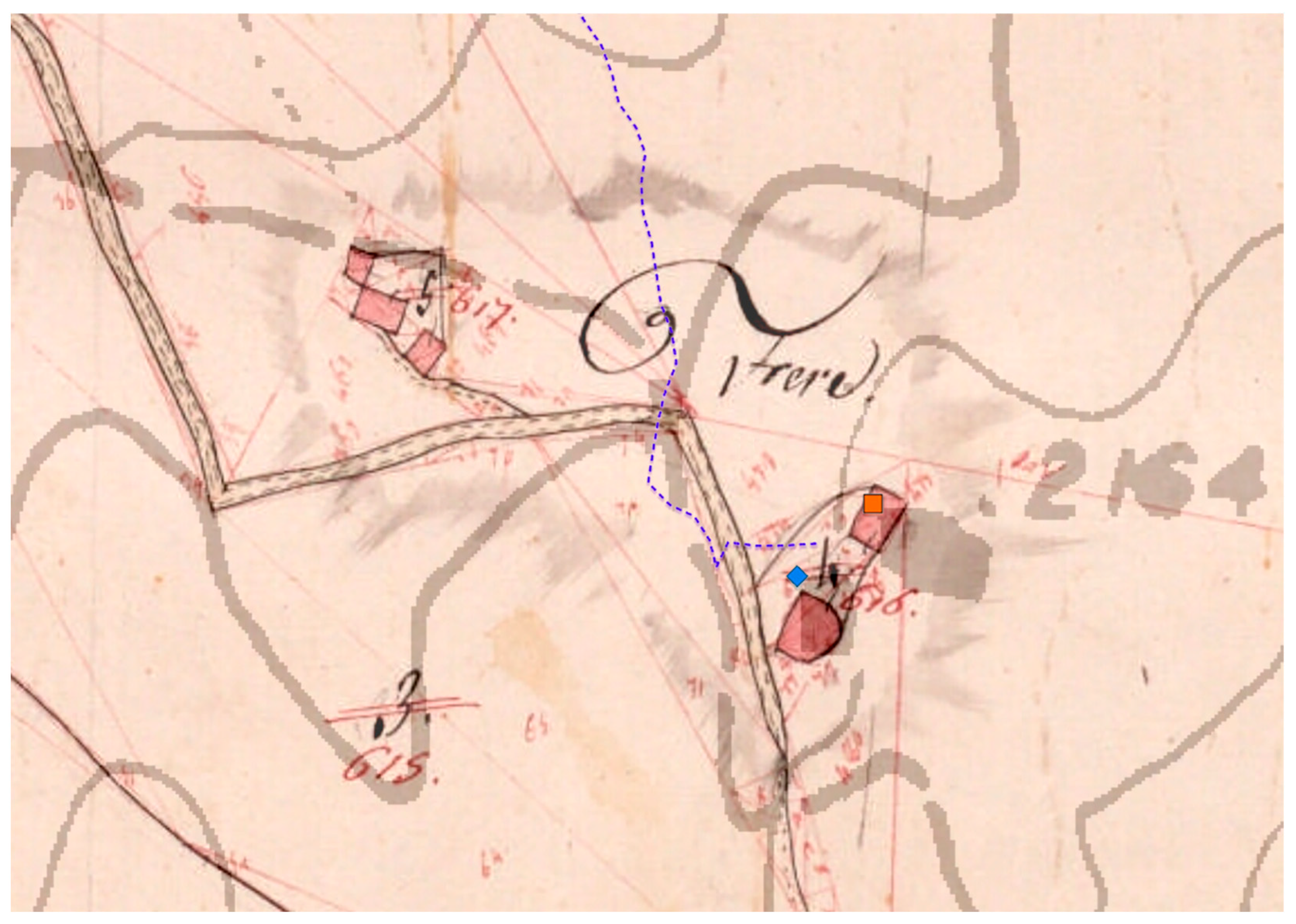
The analysis of the Registers of the Catasto Lombardo Veneto not only offered valuable information on the owners of the forges, but also made it possible to study the urban contexts graphically described on the maps within which these production sites were set up. As was customary, in Fusine as in Piateda (locality Boffetto), the owners of the forges also managed the adjacent buildings, which in most cases were used as residences and sometimes registered as “
mulino da grano ad acqua” (water-powered grain mills), the latter identifiable on the maps because they were tangent to the water channels. Furthermore, it was particularly interesting to find that in the 19th century the structures visible in Val Venina in locality La Calera were larger in number than today; they were probably intended to house workers or shelter equipment and their number confirms the significant size of the mining site [
10] (
Figure 3). The data from the activities described, using the GIS (Geographic Information System) tool, were merged with those that surfaced in the historical research in order to make them easily implementable and ready for immediate consultation and thus enable the study of the entire Orobic landscape.
Using an Open-Source GIS software and the Regional Technical Map as a cartographic basis, the evidence under study was positioned, appropriately differentiated according to its identity (vector data), such as mines, roasting furnaces, and elevated and outcropping structures. By means of cartographic filtering, it was possible to trace the vectors representing the historical routes and Alpine passes relevant to the iron industry; this will make it possible, in the future, with a greater number of case studies, to carry out thematic research and make the appropriate comparisons. It should be noted that, thanks to the survey campaigns, each element was georeferenced and thus positioned on the GIS using real coordinates (prior to this work, no structure had been mapped).
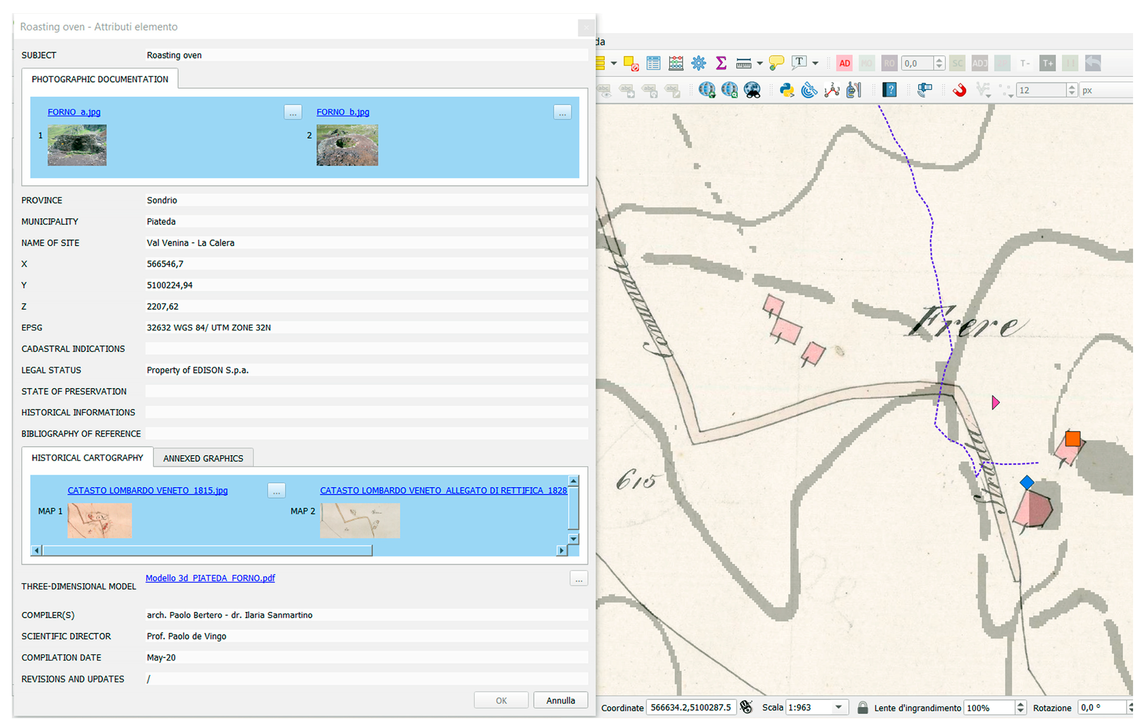
For each piece of evidence, moreover, a master data sheet was prepared, including historical and photographic documentation, graphics and the three-dimensional model; for access and consultation, simply select the symbol that identifies the object on the map and represents the type of evidence (
Figure 4). The historical cartography has been included in the system at full scale (raster data) and consequently the researcher can either compare a given map with the current situation or compare two or more historical maps at the same scale. Obviously, the vectors identifying the surveyed evidence can be superimposed on the historical maps, providing interesting keys to interpretation. This work must be considered a starting point in the graphic documentation and GIS processing of the data regarding the archaeo-mineral landscape of the Orobic side of the Valtellina, but we are equally convinced that the potential of these operations is high and spendable both in research and in enhancement initiatives.
3. History and Archaeology of Iron in the Alpine Areas
The practice of separating iron from its ore is attested in the European area from the 9th century BC. [
11,
12]. In the early Middle Ages, the transformation process took place in a closed furnace where layers of ore and natural coal were arranged; the coal was ignited while air was supplied by hand-operated bellows to fuel combustion. From the furnace, bloom was extracted, a spongy material that, in addition to iron, contained fragments of coal and ore and some pieces of steel, an iron alloy with a very low carbon content. The bloom was worked by continuous heating and subsequent hammering until it was transformed into an alloy of iron and steel. The spread of iron ore throughout all areas of Europe, including Italy, coincided over a period of almost 1500 years with a large number of processing sites and a considerable variety of smelting plants. All these apparatuses, semi-underground or sleeve furnaces, with slag collection at the top or bottom, were of a closed type and human presence was only required to check that combustion was taking place in a regular manner [
13,
14].
In the course of the late medieval centuries, Italian and European iron manufacturing experienced a new productive impulse thanks to the affirmation of new processes that allowed for an extraordinary increase in the exploitation of the ore: furnaces and forges to obtain iron and steel; furnaces for the production of raw iron (pig iron) and forges with open hearths; ironworks with open hearths for iron processing. Three different methods that, in no casual relation to the respective contexts in which they developed, and which underwent various improvements during the 17th and 19th centuries, always remained distinct from each other. The European development of iron manufacturing, a direct consequence of the application of the horizontal-axis water wheel first to the movement of hammers and then to that of bellows, coincided with an extraordinary increase in production capacity and the extraction of ore ([
13], p. 200) [
15].
In the early Middle Ages, written sources confirm that in the Alpine areas close to Valtellina, Valcamonica (in the Brescia area), Valseriana and Valle Scalve (in the Bergamo area), iron mining and metallurgy were already organised and operational to extract and process raw ore. In the area of Bienno in Valcamonica, the excavation of the site of Ponte Val Gabbia III has shown that workers capable of voluntarily decarburising pig iron existed as early as the 5th–6th century, providing a fundamental impulse to the technological perfection of iron metallurgy [
16,
17,
18]. While the transition from the direct to the indirect method represented a decisive technical innovation for the development of the iron and steel industry, it was not until the 13th century that important economic, political, administrative and legislative implications arose. The cognitive progression of both civil and military engineering skills favoured the introduction of new ore mining and metalworking techniques that would lead, especially in German areas, to the renewal and strengthening of the entire metallurgical mining sector [
19].
Medieval historical sources concerning the exploitation of iron mines in the Valtellina territory do not attest to a uniform use of these resources, since the most significant mining activities are documented, from the 13th century onwards, in the entire Bormiese area (Alta Val Zebrù), in Valdidentro, in the Livigno valley and in Val Fraele [
20]. The northern Valtellina sector is in fact characterised by the presence of rich limonite deposits, with the exception of Val Zebrù, where magnetite veins are found. Archaeological data show that urban centres, including Sondrio, received substantial quantities of semi-finished products to supply the workshops of local blacksmiths in the form of iron blocks, of standardised weight, defined in documents known as “
broza” in Bormio, “
quadrones” or “
regones” in the lower Valtellina [
21].
In 1325, Giacomo Capitanei ceded all his rights over the metalliferous veins in the Zero valley (Val Cervia) to ser Amedeo del fu dominus Ardizzone de Vallevi. In November 1452, Giacomina Capitanei, of the same Sondrio family, with the consent of her husband Antonio Beccaria, granted the brothers Donato and Biasino de Vallelevi the mountains of the Val Madre and Val Cervia in perpetual lease, and specifically the possibility of digging and owning all the existing iron veins, requiring them to pay, for the right acquired, an annual fee in baked iron [
22].
Sources also confirm significant excavation operations in the southern Valtellina region from the 14th century onwards. In the first case (Val Tartano), we are referring to the metalliferous veins located between the Valle dei Lupi and the Dordona pass, known in the local toponymy as Caxirolo, where mining activities appear in certain deeds of Simone della Porta, notary of Talamona. A first document of sale from 1344 concerns mining activities carried out in Dordona with which “[...]
Guarischi de Fondra qui stat in loco de Talamona” sells to Vincenzo del fu Pietro “[...]
de octo partibus una pars pro indiviso metali unius a fero siti in loco et territorio de Talamona ubi dicitur in Dordona”, while a second notarial deed of 1345 indicates a mining site identified as “
vene de Caxirolo” [
23]. For the second area (Val Gerola) in the vicinity of Lake Inferno, just beyond the settlement centre of Gerola at an altitude of between 2000 and 2143 m. a.s.l., both open-pit and tunnel cultivations of hematite and siderite have been surveyed and studied, the mining of which can be dated to between the 15th and 16th centuries. This is confirmed by a sub-vertical trench extending over a length of 110 m, 8–10 m deep and approximately 1.85 m wide. In this mining complex, a covered, dry-built gallery was documented, functioning as a connecting sleeve to a stone structure, probably temporary accommodation for the workers who worked in the excavation of the iron veins [
24].
4. Documentary Sources and Iron Metallurgy in the Orobic Alps: A New History
In the Orobic Valley in Valtellina, the memory of an important productive past linked to iron-working emerges from the evidence of many historians of Lombardy, such as Carlo Amoretti (1724), Francesco Saverio Quadrio (1755), Carlo Cantù (1829), Annibale Saluzzo (1845) and Francesco Giordano (1864), even though only Amoretti, Quadrio and Cantù attribute the most intensive period of mining to the historical phase that corresponds to the period of rule by the Sforza, Dukes of Milan (1450–1499).
Enrico Besta, referring to one of these testimonies, that of Francesco Saverio Quadrio, recalls that the metalliferous deposits in the Belvisio and Ambria valleys “from which much iron was extracted [...] that had been famous under the Visconti” had by then been reduced, in the first half of the 18th century, “[...] to large excavations full of water [...]” [
25] ([
20], pp. 6–7).
Each circumstance that undergoes a phase of maximum growth always requires a pre-existing substratum on which to deposit itself, grow and develop. The same can be said for iron-working in this area because, even though the medieval period, beginning from the second half of the thirteenth century, has always been considered to mark the beginning of the phase of Alpine metalworking, several documents from the rectory (
canonica) of Santa Eufemia (Isola Comacina) dating to 999 and 1006 testify to the development of this activity during a period over three centuries earlier. A notarial deed refers to the name of
Iohannes and identifies him as the
ferarius (i.e., the smith), an inhabitant of the
vicus of
Cose, a village situated at the foot of the Orobic Alps, close to Lake Como and Lake Valchiavenna, an early indication of a profession linked to iron metalworking that was already underway and thriving in the territory. The same is true for the area of the
carbonaria, referred to in an interesting document dating to 1085 that records the sale of a chestnut wood in Morbegno, because it implies the presence of the production of charcoal, an essential fuel source for the working of iron ore [
26]. The result of this production platform is confirmed in 1276 when the Bishop of Como granted Goffredo
de Capitanei the right to exploit the metalliferous deposits under the jurisdiction of the parish churches (
pievi) of Berbenno and Sondrio, in 1378 with the promise of Oldarico to deliver Arrighino de Bordogna “[…] 250
centinaria feri crudi boni neti puri de illo castro Ambrie […]” and in 1382 with the presence of a production site at Vedello (see
infra) with facilities that ensured the indirect reduction process of iron ore “[…]
pro faciendo et colando venam faciendi ferum […]” [
27]. This timeframe leaves no room for doubt about the territory’s capacity to pave the way and then, immediately afterwards, to begin the cycle of Alpine ironworking, developing mining and smelting activities both to the east of Piateda in the valleys of Belviso, Caronella, Bondone and Arigna and to the west in the valleys of Livrio, Cervia, Madre, Ambria, Tartano and Gerola.
5. Mines and Roasting Ovens in the Orobic Alps
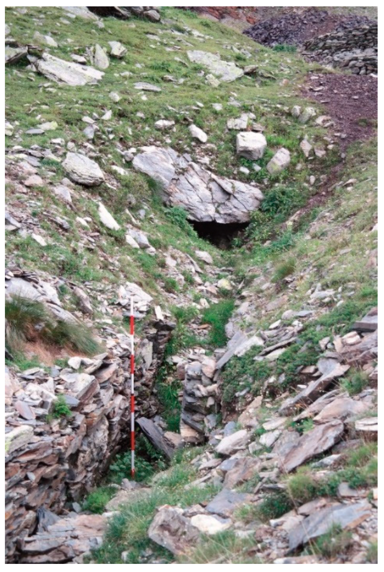
The first structure, identified as a roasting furnace, was identified along a mule track that leads up from Ambria to the Venina Pass (2442 m. a.s.l. in the direction of Val Brembana) and the Scoltador Pass (2454 m. a.s.l. towards the Livrio valley), in the
Li gèeri area, just before the point where the path begins the steep climb of the
Scale di Venina. Although the site has been largely destroyed and covered by thick invasive vegetation, it was possible to identify the loading opening and a small opening at the base, preserved partly by the dense vegetation: these are the distinctive features of a structure designed to ensure the initial “roasting” of the iron ore (
Figure 5). The
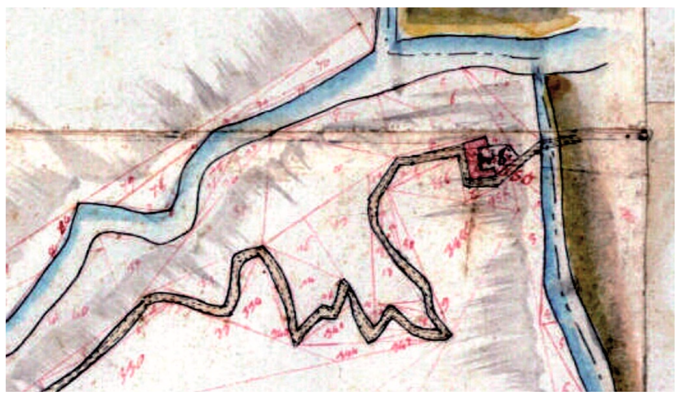
regrana (furnace) is not mentioned in local historical records. However, its presence at this point is mentioned both in the land register of the Catasto Lombardo Veneto (1815) (
Figure 6) where it is described in detail, and by the placename
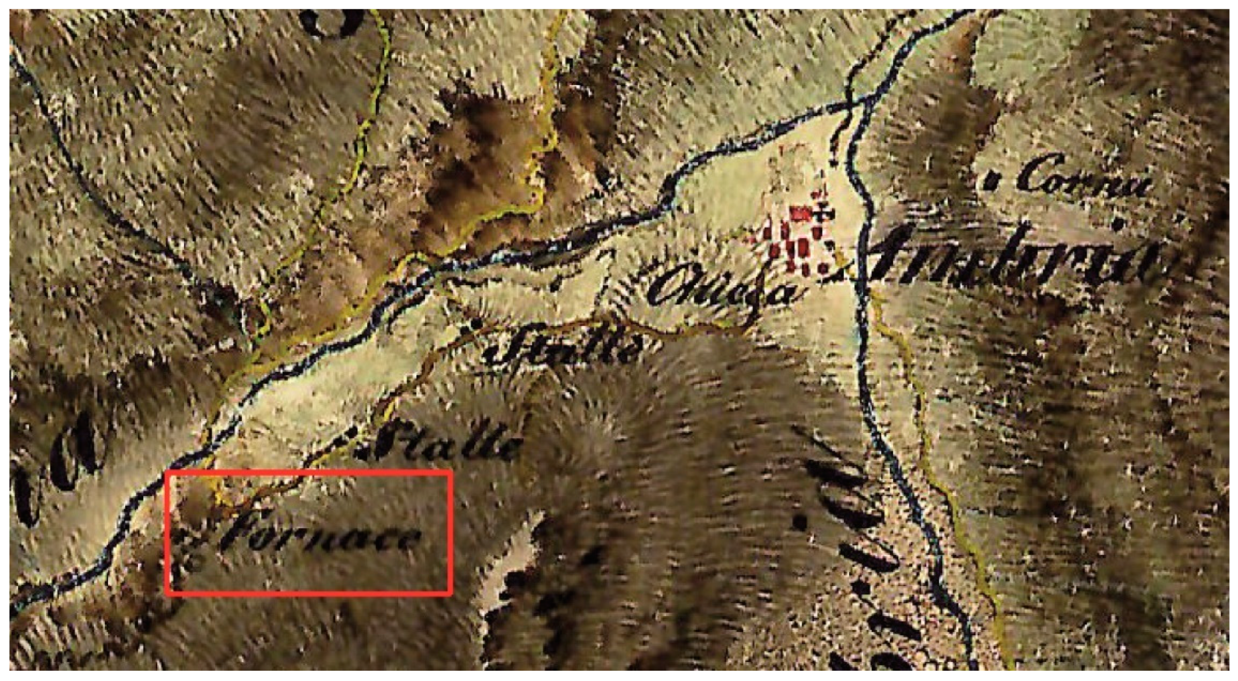
Fornace, marked a few years later on military maps drawn by Austro-Hungarian engineers (1818–1829) (
Figure 7). Nevertheless, given the current state of research, questions still remain about the provenance of the iron ore that was roasted in this structure, since the distance between this site and the mine of Val Venina, equipped with a structure capable of working significant amounts of iron ore, would appear to be too long and therefore economically unfavourable in terms of the cost of transporting the raw material. It is therefore more likely that the furnace was supplied by one or more deposits situated in the vicinity that have yet to be identified [
28].
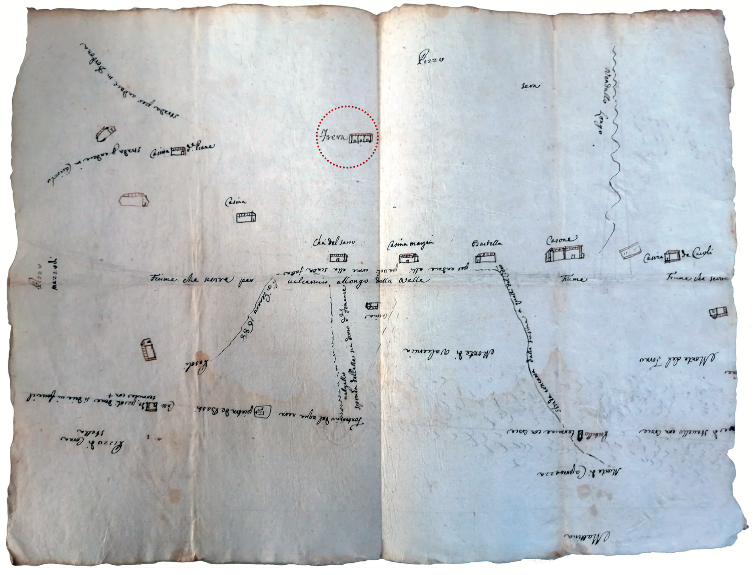
The mining context of Val Venina is situated in the uplands at an altitude of 2207 m. a.s.l., just beneath the head of the valley that separates the side facing the Orobic Alps from the one facing the Bergamesque Alps. This is the spot where discoveries were made of the remains of a productive complex consisting of several mines, structures for the initial working of the iron ore and the ruins of cabins and huts used for housing workers, mule drivers and animals. The structures were accurately mapped in the surveys conducted by the Catasto Lombardo Veneto, both in the version drawn up in 1815 and in the one done in 1853 (with subsequent amendments), where the area is marked with the placename
Frere, an indication of the presence of iron mines [
29].
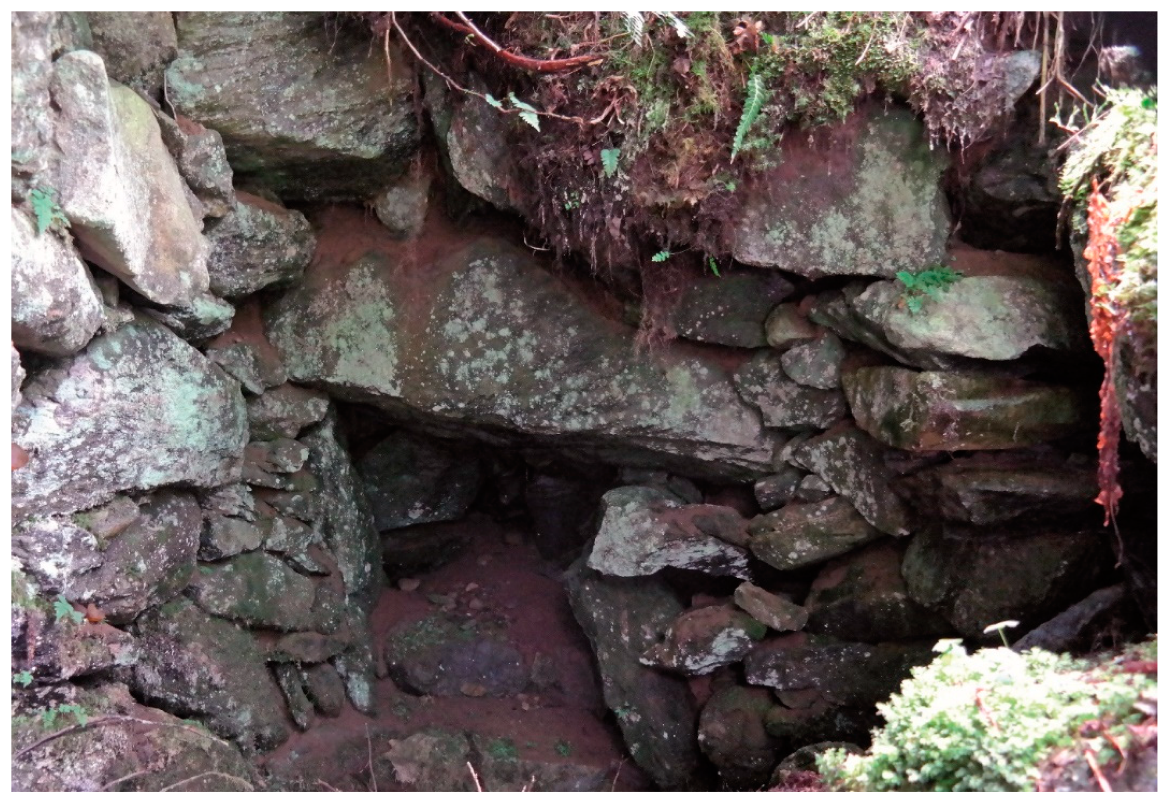
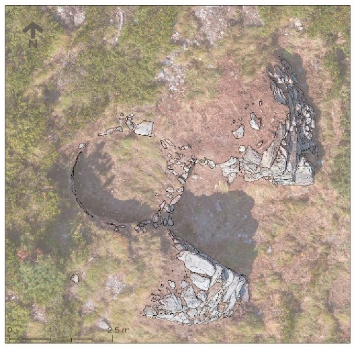
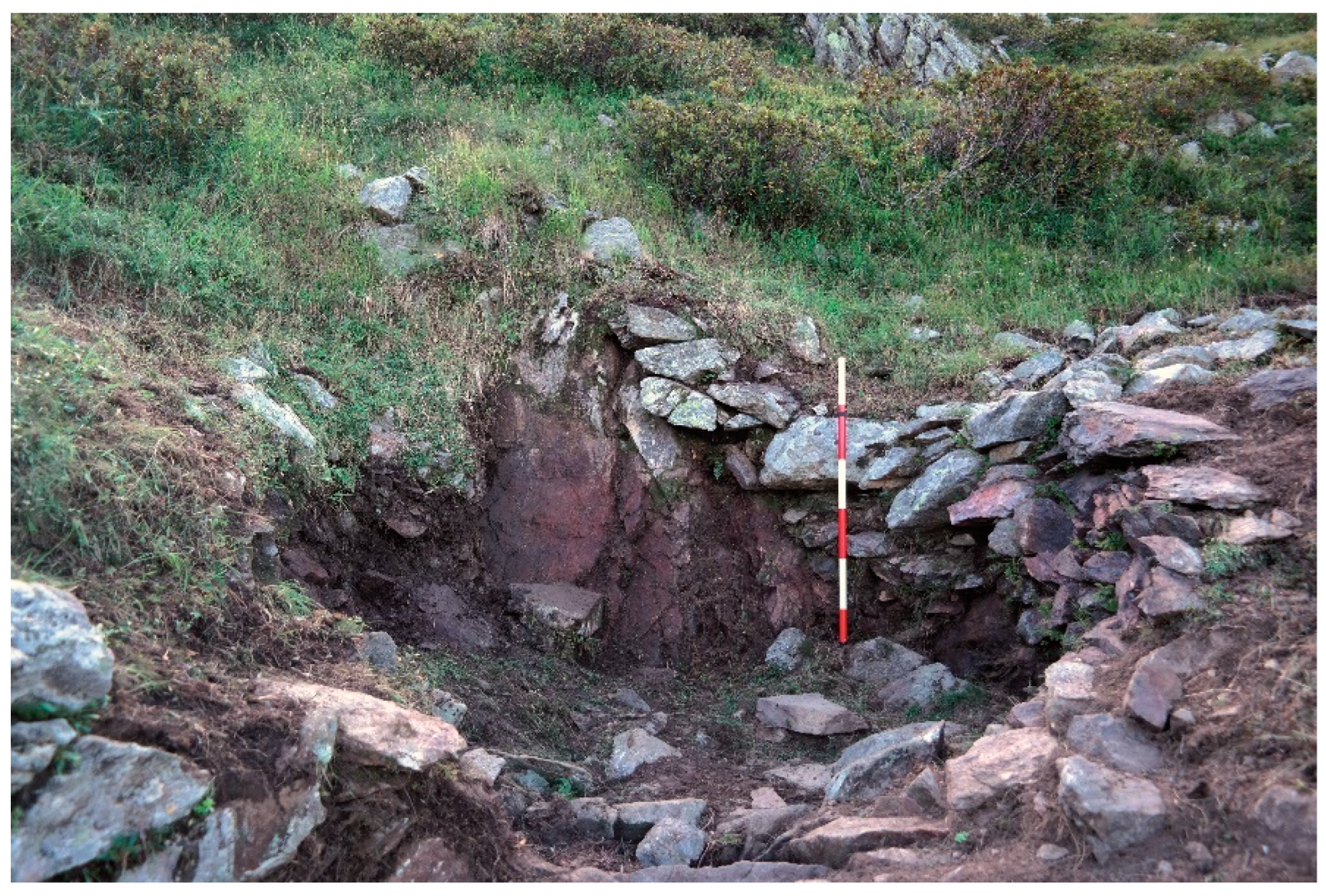
Two extraction areas, one an underground mine and the other an open-pit mine, were identified during surveys carried out in situ. The first is situated in the westernmost part of the area, a few metres away from the miners’ cabins and the blast furnace, access to which was through a narrow entrance, preceded by a long corridor (17 m × 1 m) bordered on the sides by dry-stone walls, which have now partly collapsed (
Figure 8). It is probably the nineteenth-century mine described by Melchiorre Gioia in the
Statistica del Dipartimento dell’Adda “[…] uno scavo interno al monte […]” (an excavation within the mountain), used already in antiquity and divided into several tunnels preceded by a large space [
30].
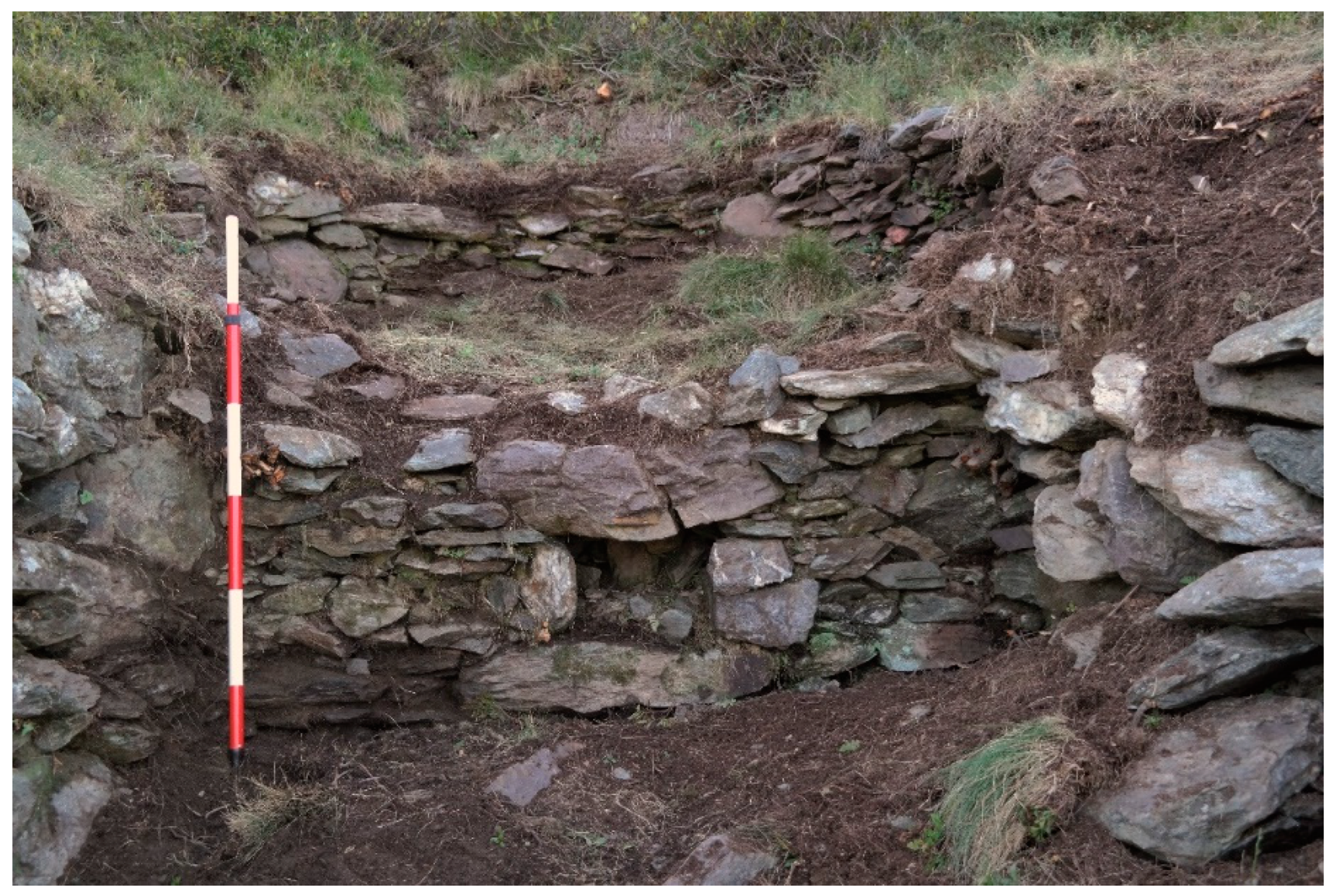
In the northernmost part of the site, there are four rooms made of dry-stone walling. The roofs of the rooms no longer survive, but the elevations, arranged around the sides of a large block of rock emerging from the ground, are partly preserved. The structures situated to the left of the boulder, partly interconnected by means of openings, can be interpreted as the cabins of the miners, while the room located on the opposite side of the rock was probably a charcoal shed or “coal house”; the building displays a fairly poor construction technique and was probably less well insulated compared to the others, since the western façade consisted only of the rockface. A fourth small room, conceivably a storeroom for equipment, was built north-west of the boulder in the space created between the boulder and the masonry structure that was built against it (
Figure 9).
Melchiorre Gioia’s book
Filosofia della Statistica describes how a company working in Val Venina consisted of 15–20 miners, called “frerini”, coordinated by a chief excavator (“capo scavatore”); some of them were involved in mining activities, others were responsible for transporting the iron ore to the roasting furnaces, while others were in charge of separating and cleaning the heated seams. The numbers were bolstered by mule drivers who, during the summer months, transported the roasted iron ore to the smelting furnace in Vedello ([
30], p. 368). Apart from those involved in transporting the coal and the iron ore, the workers were not local and mostly came from the Bergamasque department of Serio. Mining work was generally carried out in the winter months when ice restricted the amount of water leaking into the tunnels, causing hardship for the miners; the workers spent long periods of isolation in the buildings adjoining the quarries and mines, equipped with sufficient foodstuffs and wood for their needs. During the other months, they performed other activities linked to the working and transformation of the raw material (selection, crushing, roasting and seasoning) in order to organise the transport of the ore down into the valley ([
24], p. 47).
The second open-pit mine was identified in the easternmost part of the site on the slope that separates the valley from Val Zappello, where the mine resembles a sub-vertical trench just over 20 m long with an average width of 2 m. Holes (with a diameter of about 30 mm) were identified along the walls of the mine face and were used to insert explosives. This work can be attributed to the final phase of mining operations when in 1939 the “Società Anonima Stabilimenti Elettrosiderurgici Carlo Tassera (Breno, Italy)” asked the town council of Piateda for authorisation to use explosives to loosen the rock [
31].
Lastly, the most easily recognisable structure at the site is the large roasting furnace placed at the front of the entrance to the area, marked on the cadastral map of Lombardo Veneto (1815) with a feature that clearly refers to the one preserved today. The structure is made of dry-stone walling with dimensions that reach a maximum of about 4 m high × 10 m wide; the eastern part of the construction appears to be built against a natural knoll behind, upon which there is a large mound of abandoned iron ore (
Figure 10). The central part of the structure contains a large belly in the form of a shaft that tapers at the base, with a circular mouth with a diameter of 4.5 m and an overall height that must have corresponded to about 3 m, although the precise dimensions cannot be determined due to the presence of debris and residual iron ore in the inner cavity. At the centre of the huge façade there is a deep arched opening, in the lower part of which there is a second, smaller quadrangular opening. Two dry-stone walls marked the limits of the flat area in front of the furnace, although only a few courses of the walls are still preserved ([
28], p. 232).
The structure was used to roast the iron ore, in other words to carry out an initial “cooking” designed to eliminate most of the impurities that could be altered in the heat within the excavated cavity. By the end of the process, the iron ore had lost roughly 25% of its initial weight, facilitating the transport of the material to the reduction sites. The central space of the furnace was filled with layers of charcoal and iron ore, eventually reaching 3/4 of the total volume; loading operations were facilitated by the large loading opening of the furnace and by the ledge provided by the knoll situated behind it. The roasting process took several hours until the charcoal had been used up, and the workers in charge of the furnace had to monitor the opening at the base on a constant basis to ensure that the fire did not go out or overheat. Once the combustion phase had ended, the iron ore was deposited on the bottom and, once it had cooled, was extracted using shovels through a small opening. The seam subsequently underwent a lengthy period of weathering in the open air so that the elements removed the impurities still present in the ore, after which it was crushed into small pieces and transported down into the valley, where it was reduced in smelting furnaces. These operations were carried out in the area in front of the furnace, where plentiful levels of small pieces of roasted iron ore are still scattered over the whole area. These activities, like the ones that preceded the roasting phase (selection and initial crushing of the seam), formed part of the tasks undertaken in the summer months close to the mine. Even though the material structures used in the process have undergone numerous technological transformations over the centuries, the methods for preparing the iron ore remained largely unchanged [
32].
A second roasting furnace, which can be identified as a structure in the easternmost sector of the site, situated a few metres away from the open-pit mine, has been largely stripped (possibly due to the reuse of the stone employed in its construction) and obstructed by debris and iron ore refuse. Nevertheless, a visible furnace remains, observable through aerial photography, bearing a striking resemblance to the plan of the furnace described above, albeit on a slightly smaller scale (9 m × 5 m). The structure is not included in the cadastral map of the Catasto Lombardo Veneto (1815), so its use may date back to an earlier phase. The furnace may well have been abandoned due to malfunctioning or abandoned to construct the existing one, which was sufficient and more practical for the productive needs of the site ([
28], p. 234).
6. Iron Metallurgy in the Orobic Alps: The Vedello Blast Furnace
The settlement of Vedello (1032 m) is situated in the point in which Val d’Ambria is divided between the branching of the Ambria and Venina rivers to the west and the Caronno and Vedello rivers to the east, at the confluence between the Venina and Caronno rivers. The construction of a smelting furnace at this point was strategically important due to its proximity to the areas supplying the materials required: the iron ore and the wood charcoal came from the mines and woodlands in the valleys above Vedello, where all the routes (paths and mule tracks) used for transport converged, while the confluence of Venina rivers in the Caronno river guaranteed the water capacity required to power the bellows of the plant.
The first indirect reference to the furnace can be found in a document of 1212, where
Morescus Magani de Furnis de Vedello de Trisivio appears as a witness in the deed of the sale of land between two inhabitants of Tresivio [
33]. It is not until the end of the following century that we have more detailed information about the structure and its location in the district of Vedello, when the roasting furnace crops up in a series of notarial deeds regarding the sale of the furnace itself or other adjoining property. The boundaries mentioned in a deed of 1382 indicate that the structure was situated “
a mane flumen Caronni, a meridie ser Taloli de Ambria accessium mediantem mediante, a sero via communis et a nullaora suprascriptum flumen Caronni in parte et in parte via communis”. In 1470, the furnace is mentioned in a notary deed regarding the sale “
de piazo uno in territorio de Trixiviomonte in contrada de Vedello prope furnum cui coheret […]
et ab altera suprascriptum seu carbonile ipsius furni strata mediante” and seven years later, in 1477, another document describes how “
in valle de ambria in contrada de vedello quibus omnibus coheret a mane communis vide licet plaza et carbonilia furni a ferro a meridie assero strata et a nullaora flumen caroni” ([
27], pp. 90–91).
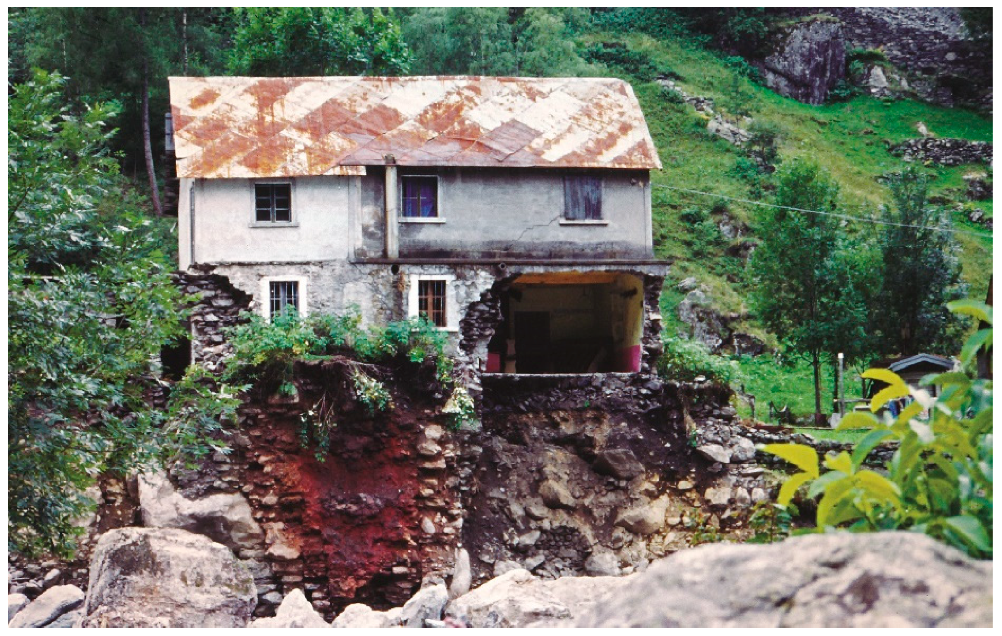
The furnace therefore bordered the Caronno river to the east, the property of an inhabitant of Ambria to the south, the municipal road to the west and the Caronno river and part of the municipal road to the north. The position is the same as the one on which a new furnace was built in 1803, as is indicated by the structure surveyed in the land register compiled by the Catasto Lombardo Veneto (1815). It was in this spot, following heavy flooding in 1987, beneath what corresponded to the “Privativa Tavelli”, that the Caronno burst its banks, bringing to light ruins belonging to the nineteenth century structure, subsequently incorporated into the retaining wall built to stop floodwater (
Figure 11).
The information contained in late fourteenth-century documents shed light on the technological features of iron working at the structure in Vedello. More specifically, the reference
pro faciendo et colando venam faciendi ferum indicates that the blast furnace was capable of ensuring the indirect reduction of iron; the plant therefore had stable structures that were fairly sizeable. This technological innovation, which originated in the valleys near Brescia where the production and spontaneous decarburisation of pig iron had been practised since the fifth/sixth century, became firmly established from the thirteenth century onwards in the Lombard Alps before spreading to the rest of Italy and subsequently, when the production process was at its height, to many areas in Europe [
16].
In the territory of Valtellina, the first evidence for the adoption of this procedure dates to 1269 in the area of Bormio (furnace at Semogo), and it subsequently spread throughout most of the Orobic valleys such as Val Gerola (furnace at Costa, 1294: furnaces in
Cagamozio, 1326), in Val Tartano (1347, furnace at Consegio in Talamona, 1348), in Val Cervia (furnace at Cedrasco, 1378) and in the same year in the nearby Livrio Valley ([
30], p. 364) [
34,
35,
36,
37]. Using this procedure, it became possible to split the production process into two phases. During the first phase of the production cycle, the skilled workforce used a blast furnace to smelt the iron ore in order to obtain pig iron (known as
ferrazzo,
ferro grosso or
ferrum crudum) while, in a subsequent phase, they transformed it into iron (
ferro cotto,
ferrum coctum) or steel through a process of decarburisation (i.e., a second “cooking”), which took place in refining forges known as “fucine grosse”, where the iron was beaten with a drop hammer to create semi-finished products of various types. By using the indirect smelting process, it became possible to produce pig iron in a continuous cycle without the need to interrupt combustion, as was the case for the traditional direct smelting process (
bassofuoco), in order to obtain the metal bloom and introduce fresh charcoal and iron ore. This procedure also enabled the extraction of a greater percentage of iron from the ore, considerably reducing the amount that was lost during the production process ([
32], p. 101) [
38,
39,
40,
41] ([
13], pp. 205–206).
In 1584, the blast furnace at Vedello was operational, as is shown by the equipment listed in the will of Castellino Beccaria (work tools, seven mules for transporting the iron ore or the charcoal and fifteen carts loaded with hay to feed the pack animals); in the following years it was predicted that the structure would operate at full capacity, thanks to the capital—the princely sum of 2000 gold
scudi—invested by the company set up by the Beccaria and Morandi families to run it ([
27], p. 83).
A document dating to 1591—in which the Beccaria brothers sold the blast furnace to Alessandro Carcano—is the first source that provides a detailed description of the smelting process. The building had a rectangular base and was arranged on two storeys: the lower vaulted level measured about 10 m × 5.5 m, while the upper storey measured about 10 m × 8 m; the roof was made of wooden planks. Entry to the furnace room was via a large door with a chain and lock, while the upper floor, which also had an entrance, did not have any specific security system. The inner part of the furnace contained the
caneccio, the local term for the reduction tower or stack in which the iron ore was reduced; the measurements of the structure are not given, but the overall height reached the upper floor, where the loading opening was located [
42,
43]. The actual smelting process was preceded by a phase of heating the furnace during which the
caneccio (stack), filled only with charcoal, was lit for the whole day to eliminate damp within the structure. It was during this preparatory period, which could last up to several weeks, that the ironmaster in charge of the furnace demonstrated his expertise. He was entrusted with the task of obviating or solving the technical problems that might crop up during the smelting process because, once lit, the furnace remained active for months at a time [
44]. After the preliminary checks had been carried out, the iron ore was loaded into the stack (
caneccio), alternating with layers of charcoal. Inside the furnace, the iron ore underwent a series of chemical and physical reactions and processes according to the temperatures produced at the different heights of the structure. The smelting point was reached in the zone of the
presura, the lower part of the furnace where air was pumped using bellows; at this point, the bosh narrowed considerably in the lower part of the furnace and the iron ore, restricted by the bottleneck, formed a sort of vault through which the slag (
loppa) and the pig iron could be collected and poured. Firstly, the slag floating on the crucible was poured off using special tools with duck-billed spouts (
raspirolle and
lacciaroli) and the pig iron, dragged into a pool of running water (
pozzo), known as a
rampino, was subsequently drained ([
22], pp. 232–233).
The ironmaster’s tasks included the preparation of the iron ore for smelting, generally from different seams, checking the exposure to the fire of the right quantity of ore and regulating the constant flow of air into the furnace to ensure that the iron-making process took place at a steady rate. At Vedello the ventilation system involved a pair of bellows (mantici), described as new and equipped with all the mechanisms required for their efficient functioning; the air was introduced into the furnace via a single tuyere (canna). The bellows were activated by the force of running water, channelled from the Caronno river through a system of canals (canali aquedutti). The air supplied by the bellows was regulated by the flow of the water to the wheel (rota) fitted with a wooden shaft with an iron rim (arbore con vere dieci di ferro) which transferred the movement to the drive shafts of the bellows (braccioli). The furnace complex included other rooms, including a large storeroom used to store the charcoal (carbonile) capable of containing from 400 to 500 sacks of fuel, and a well-guarded room for storing iron ore (venaiola).
At Vedello, there was a fairly large complex equipped not only with the furnace and the machinery required for it to function, but also permanent ancillary buildings, as well as accommodation for the workers, even though this is not mentioned in the document. The costs of running the furnace must have been high, including the sourcing of supplies (iron ore and charcoal) with relative transport expenses, the payment of the workforce (employed in all phases of the production process) and the frequent maintenance of the structures and machinery of the
caneccio. Unfortunately, the available documentation does not provide precise indications about the names and origins of the workers who constructed the furnace, or the number and tasks of the people who were in charge of its functioning; there is also a lack of data about productive capacity, even for the years between the sale of 1591 and 1803, when it is known that a new furnace was constructed by the company directed by Gaspare Sacchi, designed to exploit the mines in the territory of Piateda ([
28], p. 244).
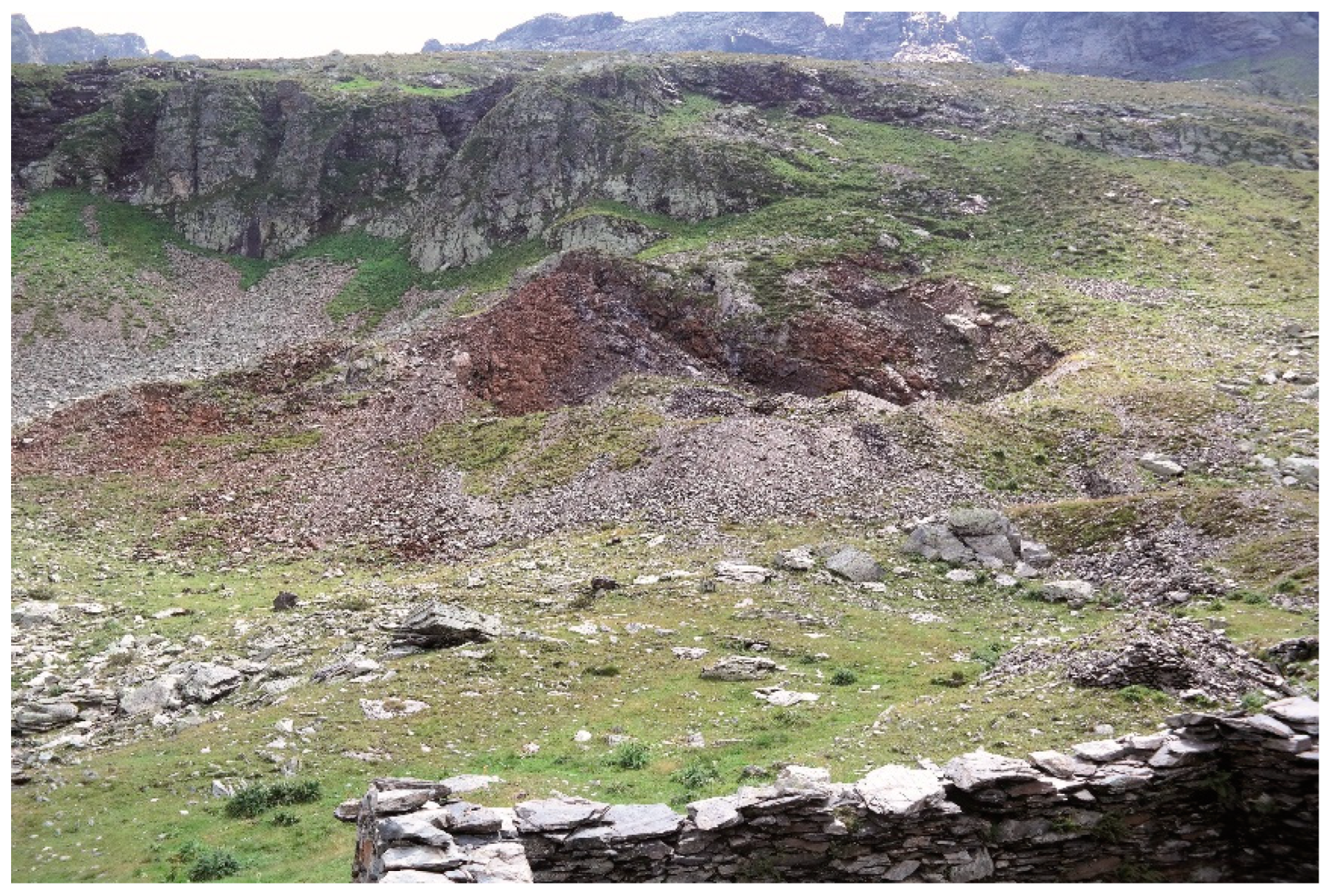
Moving westwards towards Piateda, the research focused on the territory of Fusine, particularly on the uplands of Val Cervia where, at an altitude of over 2000 m above the peak of Cima Vitalengo, a series of structures linked to mining and initial working of the iron ore have been documented. The ruins of a siderite mine, probably the same one that appears on an old map of the uplands of Val Cervia made in 1688, are visible on the eastern slope in the district of
Le Flerie [
45] (
Figure 12). It is a large open-pit mine covering an overall area of over 115 m with a difference in height of about 80 m. The mine consists of a large subvertical trench that corresponds to the layout and thickness of the seam, with an average thickness of 2 metres and average depth of 5–7 metres, even though the latter measurement cannot be calculated precisely due to the quantity of material that has collapsed onto the mine floor [
46] (
Figure 13).
The siderite deposit, which almost certainly constituted the working face, is situated in the highest part of the mine situated at an altitude of 2282 m. a.s.l. and is still clearly visible. The technique employed appears to be cut-and-fill stoping (“gradini rovesciati”): mining operations began on the lowest part and subsequently, sometimes using wooden scaffolding, work proceeded by removing the upper part and leaving useless and waste rock on the floor. In order to avoid dangerous collapses, parts of the rock were often left to act as supports between the faces of the mine; one of these is still present in the final part of the mine at the point where the trench narrows significantly. As far as techniques are concerned, it is reasonable to suppose that mining was conducted using pickaxes or using the traditional system of pick and chisel because the mine faces are smooth, the rock is not fragmented and there are no signs of holes. Besides this method, fire may have been used to “cook” (roast) the rock and facilitate its removal. In the upper part of the mine, the faces are irregular and extremely fragmented, probably due to the use of explosives and therefore more recent mining operations compared to the extraction carried out below ([
46], p. 323).
Once it had been extracted, the mined ore was probably left in the area in front of the entrance to the mine, bordered by two dry-stone walls, which have been partly preserved. Here, the iron ore underwent initial selection and crushing (using sharp tools), with the aim of eliminating the largest possible amount of country rock surrounding the iron ore. Before it was sorted, the mined ore could be left to season at the edges of the mine so that weathering and frost shattering could act upon the interfaces between the ore and the rock, leading to natural detachment. Like the situation encountered at Piateda, the iron ore underwent an initial process of “roasting” in specially made shaft furnaces known as
reglane (the Bergamesque dialect term), carried out in the immediate vicinity of the mines in order to facilitate the journeys made by porters and pack animals and, as a consequence, to reduce transport costs as far as possible ([
32], p. 101).
Two roasting furnaces were found close to the mine, just beyond the steep ravines that border it to the north and the south. They are extremely similar in shape and size and both have been partly damaged by collapses caused by landslides. The structures identified in Val Cervia, which are fairly similar to each other, consist of a large chamber embedded into the slope, with slightly splayed faces made of dry-stone walling and partly made by exploiting the natural rock (now no longer visible due to earth and debris accumulated in the chambers). The façade of the furnace is supported by a retaining wall, built both to counteract the steep overlying slope and to improve the thermal insulation of the production site; on the downstream side, and therefore in the direction of the mountainside most exposed to air currents, it forms in both structures two massive projecting parts, slightly diverging from each other, in which the slag outlet is located ([
46], p. 324) (
Figure 14).
The circular loading opening is free and facilitated the loading operation from the upper side, exploiting the ledge provided by the foundation wall. The shaft has diameters of 2.30 m and 2.50 m, while the overall height, as far as it is still visible, is over 2 m. In the furnace to the north of the mine (2230 m), it is possible to identify the small slag outlet placed at the base of the façade of the structure, quadrangular in shape and a few decimeters wide (0.25 m × 0.30 m), through which the roasted material was unloaded (
Figure 15).
In the second structure (2177 m), where the furnace chamber is easier to inspect, thanks to the fact it is more deeply interred, there are visible traces of reddening and corrosion on the inner walls of the belly, which formed as a result of the prolonged use of the structure (
Figure 16).
The two locations of the mining and roasting operations were connected by a mule track that, in the steepest parts, is just a basic path but was carefully paved in the more level parts; part of the paved track outside the furnace situated to the south of the mine is still visible. The path that begins from the second furnace, situated further north, is also clearly visible; with only a slight difference in height, the path rises, diagonally cutting the slope of the mountainside until it reaches the crest that separates Val Cervia from Val Madre. Here, just below the peak of cima Vitalengo (2407 m a.s.l.), at an altitude of 2302 m, are the ruins of the cabin used as accommodation by the miners and other workers.
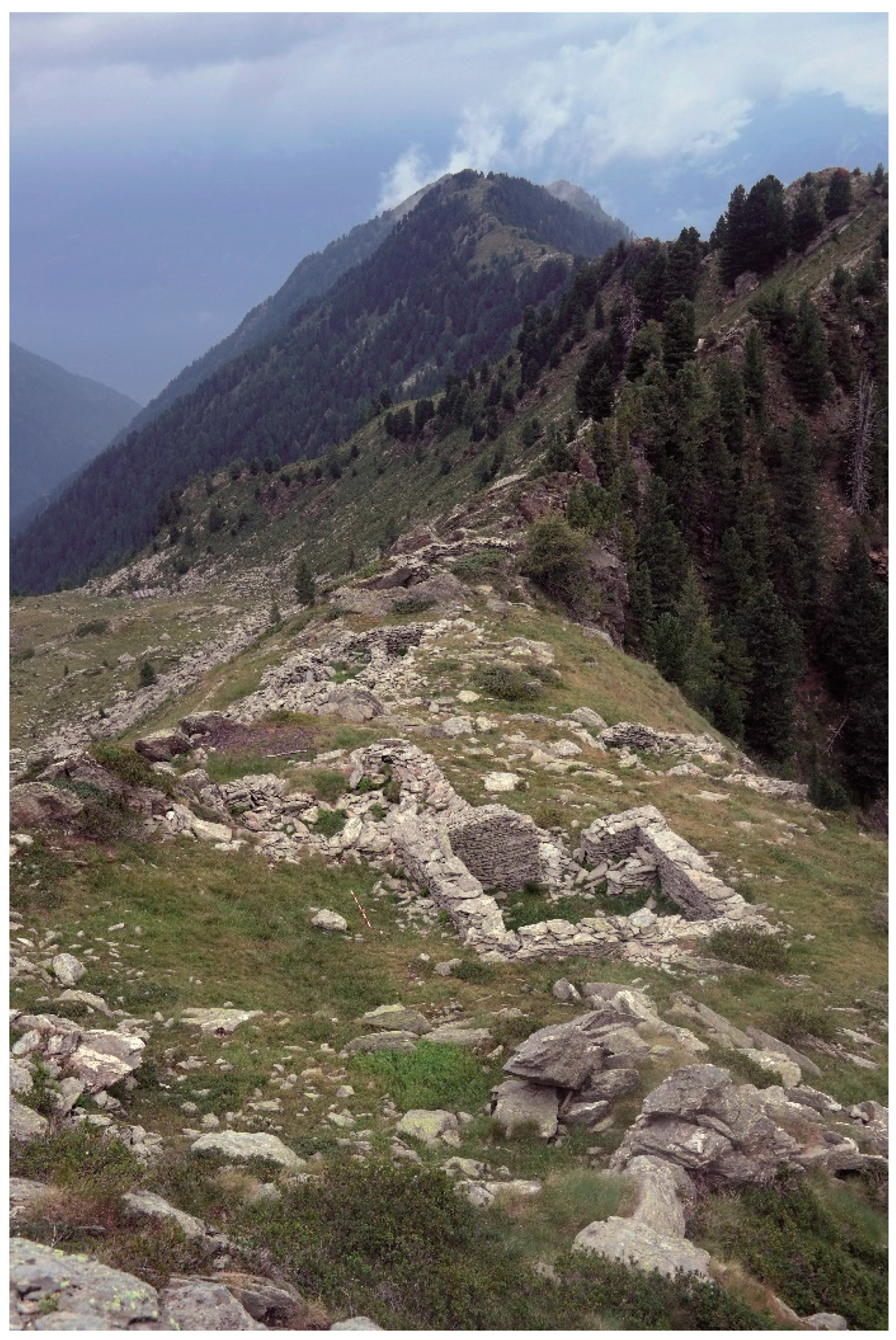
The site, which occupies a surface area of about 1400 m
2, is situated on a fairly level saddle along the ridge separating the two valleys in a favourable position, which could receive sunlight throughout the day, especially in winter, and was not exposed to the dangers caused by avalanches and landslides, which were undoubtedly frequent phenomena in this upland terrain (
Figure 17). The context consists of five buildings of which the only surviving features are parts of the perimeter walls that are made of dry-stone walling and, in some cases, take advantage of the outcropping rock that acts as natural walls. The cabins situated in the highest part (buildings 1 and 2), whose elevations are the most clearly interpretable, were probably used as accommodation for the workers, a hypothesis indicated by the dimensions of the two structures, larger than the others (about 6–7 m wide), and by the bonding of the masonry, which was carefully constructed with regular courses. The inner southern façades of both buildings still preserve small niches made in the masonry, possibly used for oil lamps to provide lighting for the rooms.
The position of the structures offered a complete view of the area below, as well as of the whole valley. The remains of two other buildings are visible at a distance of about ten metres away from the ones described above: only the foundations of the easternmost structure (building 3) are preserved, except for a few stretches of walls with a few courses still intact, while the elevations of the perimeter walls (maximum height c. 1 m) of the second structure (building 4), since it is partly incorporated within the bedrock, are still partially visible. While the function of the former building is unclear, the long plan of the second structure (c. 14 m × 7 m), divided into at least three rooms, subdivided by partition walls, could indicate the presence of a storehouse, used to preserve provisions for the workers or as a coal house or woodstore, as well as a place for keeping fodder for the pack animals. Outside building 4 is a clearing where numerous small roasted fragments of siderite were found. This was probably an area where the initial selection of the ore was made, followed by manual crushing. These operations were carried out in the summer months when, in most cases, mining work was unfeasible. Lastly, beyond the storehouse, in the northernmost part of the area, is the last structure of the site (building 5), the walls of which are also preserved to a maximum height of just over a metre. The building has a less regular plan than the others, due to the outcropping rock, partly used as a support for constructing the perimeter walls. This evidence, together with the construction technique of the walls—much more irregular and slapdash than the other huts and therefore with a lower capacity for thermal insulation—suggests that the structure may have been used as a shelter for pack animals or as a storeroom for work tools and a space for keeping and repairing mining equipment.
Lastly, on the right slope of Val Madre, between Casera Vitalengo and the hut of Vendullungo, another roasting furnace was discovered, with several adjoining structures made of dry-stone walling (2156 m). The complex, which is fairly well preserved, displays the same construction technique as the structures recorded in Val Cervia, although it is larger. The shaft into which the iron ore was loaded, alternating with charcoal or wood (unfortunately covered in debris), reaches a height of 3 metres, while the stack has a maximum diameter of 4 metres. Traces of other buildings, of which very little of the elevations is preserved, have been found on the outer side of the structure, probably used for ancillary buildings for the furnace, such as storerooms for equipment and charcoal. It is harder to establish from which deposit the raw material for the production site came from. Although the most plausible hypothesis is that there was a mine in the immediate vicinity of the complex (yet to be located), it cannot be excluded that the furnace, which is likely to be more recent than the
reglane described above, is related to a subsequent phase of extraction from the mine in Val Cervia, related to the opening of the smelting furnace in Val Madre that took place in the early eighteenth century [
47].
7. Discussion: What Now Remains of Orobic Metallurgy
With regard to the areas of Valtellina in the late sixteenth century, the only relatively precise evidence for reconstructing the type of furnace adopted for iron working comes from a single complex (1591), situated at Vedello. On the basis of the available data, it would appear that the facilities were contained within a single building, and therefore not in open areas, and that the most commonly used early type of blast furnace was the
cannecchio used in the areas of Brescia and Bergamo, powered by hydraulic energy. The construction of ironworking structures of this type required considerable technical expertise, significant precision and care in the preparation of hydraulic infrastructure, channels and a wheel for providing the power supply for the complex [
48]. The documents reveal strict spatial organisation limited by the position of the drive shafts of the hydraulic wheels.
The reconstruction of the technology used in the ironworking complexes in the Valtellina area and, more generally, the possibility of understanding the organisational and management system of medieval metallurgy, has proved to be extremely difficult and complex due to the lack of documentary evidence. Surveys carried out in the area suggest the prolonged use of preserved production sites, while the destruction due to natural phenomena of one of the oldest ironworks—the one at Verdello described in the documentary sources—has significantly hindered attempts to provide precise dates for the production sites, which consisted essentially of roasting furnaces situated at medium-to-high altitudes in Alpine environments. The same observations hold true for the forges, considering that in the specific case of Fusine, of all the ones listed in the sources, the only surviving forge belonged to the Bazzi family.
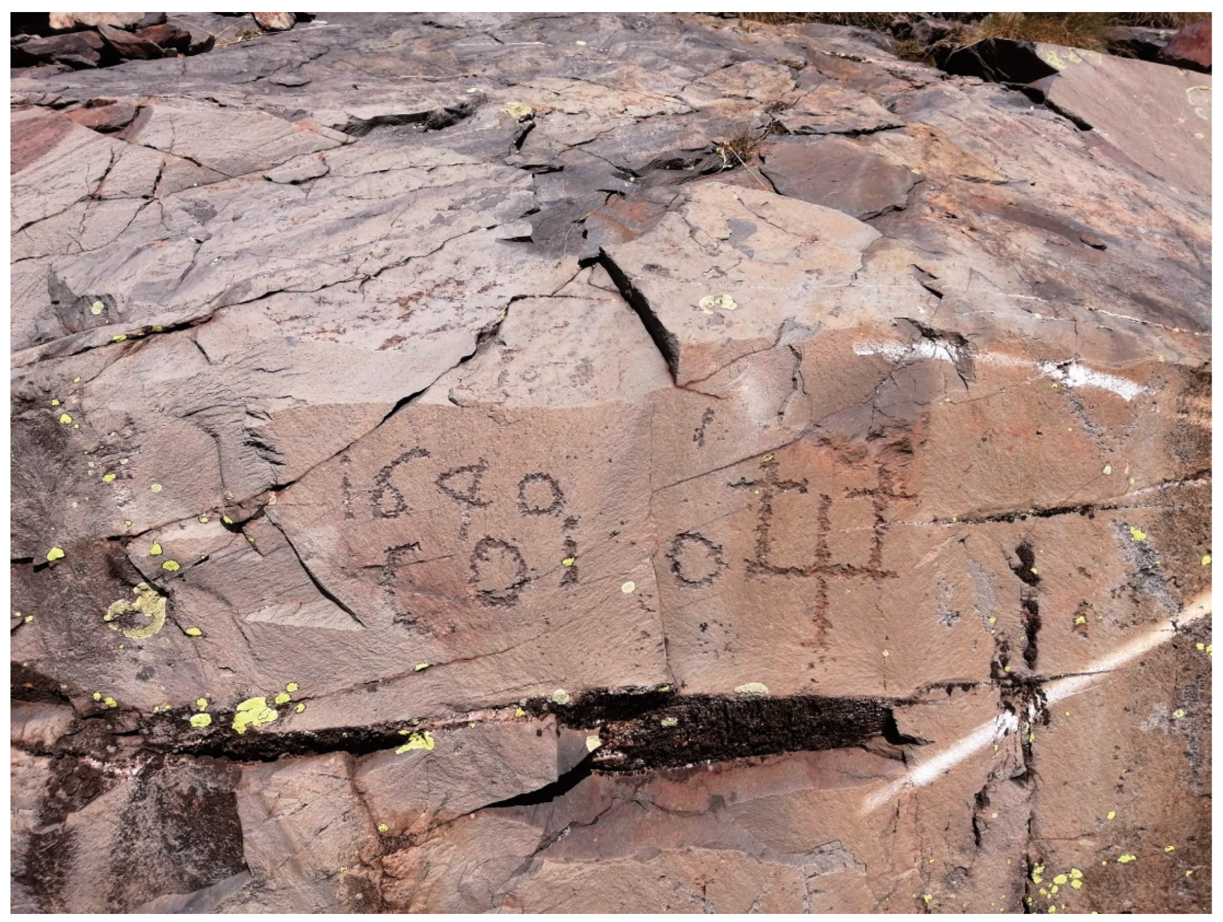
It is also worth adding that when the identification of a mine is accompanied by a date engraved close to its entrance and a direct relationship is plausible, the written sources provide scant evidence about the exploitation of the seams of iron ore and it is unclear whether the date given (
1640 for the deposit in the Scigola Pass and
1657 for the Scaletta Pass) refers to the initial or final phase of the mining operations. In the cases examined here, it is extremely likely that the engravings were made with two stone hammers or with an iron hammer and chisel. In the first case (Scigola Pass), the engravings are arranged in two distinct panels alongside each other. The upper part of the first panel contains four numerals “1 6 4 0” while the lower part has two traces with a curved profile followed by a circular design next to a short perpendicular rod surmounted by a point in the form of a “[c?]” or “I”. In the panel next to the previous one, it is possible to discern a circular design beyond which is a Greek cross reinforced with two Latin crosses on the outer edges parallel to the rockface “o †+†” (
Figure 18).
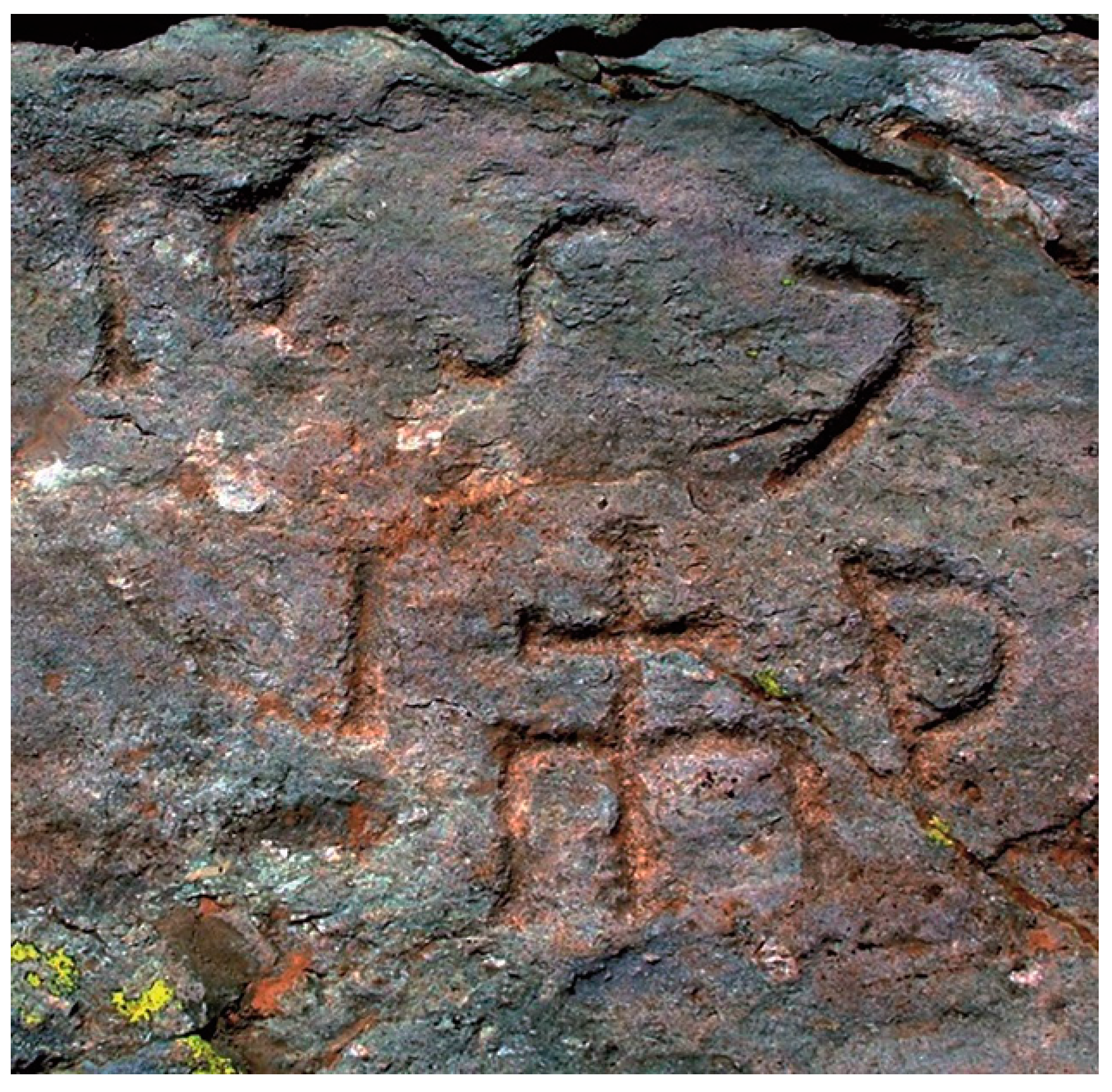
In the second case (Scaletta Pass), there is a single field divided into two parts: the upper one has four numerals “1 6 5 7”, with curvilinear engraving, while the one below features the letter J (?) followed by an E arranged parallel to the rockface and a Latin cross grafted onto the shorter part of the vowel with two small cylinders inserted on the short arm, accompanied by a P (
Figure 19). The height and inaccessible nature of the two contexts prevent the precise identification of the author, or authors, of these precious historical sources. The altitudes of the engravings are beyond the limits of pasture for livestock in the Orobic valley of Valtellina, generally between 1400 m and 2200 m, but it is equally true that the two passes are the crossing points between two opposing Alpine mountainsides. This suggests that the shepherds involved in transhumance or moving livestock between the Orobic valley and the Bergamesque valley were responsible for the engravings, but it does not shed light on their meaning, which remains incomprehensible.
If, on the other hand, the executors were the workers involved in extracting material from the seams of iron ore, then it is possible that the first series of numerals corresponds to “1640” and the second to “1657” and that they therefore represent the initial or final dates of mining activity. The few signs that have been identified may be interpreted as alphabetic letters and therefore constitute the initials of the name of a person, accompanied by symbols related to identity or origin, so that the ownership of both mines—Melchiorre Gioia alludes to the excellent quality of the iron ore and therefore to the greater economic importance compared to other extraction sites—was visible; no one could consider them to be abandoned and the owners were therefore easily identifiable ([
28], pp. 227–229).
The hypothesis that the mining sites of Valtellina were exclusively for personal use, a view that was widely shared until a few years ago, has been completely disproved. Furthermore, the greater originality and effectiveness of our research can be recognised through the capacity to extend the chronology, differentiating between eras and areas, following a temporal transformation of the economic, social and technological aspects, without which it would be impossible to recognise and understand the mining landscape of Valtellina. Historians of mining and ores underestimate the importance of archaeological evidence, while archaeologists frequently play down the significance of the written sources. Archival sources suggest the active presence of numerous players—with a key role played by local aristocratic families (the Curtoni, Ruffoni, Quadrio, Beccaria and Capitanei families during the Middle Ages)—and a surprising level of productive complexity within an economic context mainly related to trade and the supply of production units situated beyond the Orobic valley of Valtellina.
It is worth underlining that the commercial importance of metalworking was not confined to purely local productive decisions but was targeted at a much wider market than hitherto believed. On the basis of the evidence of notarial deeds, it can be concluded that the internal market was the main point of reference between the eleventh and sixteenth centuries, although it was not the only one for ironworking artisans in the Valtellina area. It was an extremely extensive commercial environment involving aristocratic families with considerable purchasing power, a fairly sizeable population, numerous clerics and a steady stream of merchants (
mercatores) and pilgrims along the main Alpine routes. However, the relative prosperity of the artisans (often owning a house and a vineyard) did not stem from the success of their products but rather from the possibility of devoting themselves to other activities, especially in the agricultural and woodland-cum-pastoral spheres [
49]. This reflects the presence of a high degree of specialisation in conjunction with significant capital investment in production by local aristocratic families or individual merchants (
mercatores) who realised that the possibility of selling raw or semi-finished material to Milan or Bergamo could provide a much more reliable source of income and profit than involvement in financial operations, from which they seem to have distanced themselves.


