
Dynamics of Mountain Urbanisation: Evidence from the Trans-Himalayan Town of Kargil, Ladakh, India

1
Department of Geography, South Asia Institute (SAI), Heidelberg University, 69115 Heidelberg, Germany
2
Heidelberg Center for the Environment (HCE), Heidelberg University, 69120 Heidelberg, Germany
*
Author to whom correspondence should be addressed.
Land 2023, 12(4), 920; https://doi.org/10.3390/land12040920
Submission received: 20 March 2023
/
Revised: 10 April 2023
/
Accepted: 17 April 2023
/
Published: 20 April 2023
(This article belongs to the Special Issue Socio-Economic, Environmental, and Political Aspects of Rational Management and Land Use/Cover around the World)
Abstract
:Small and medium-sized towns in the high mountain regions of South Asia are characterised by rapid and mostly unplanned urbanisation processes, regularly resulting in an increased risk of urban agglomerations being exposed to natural hazards. After the administrative capital of Leh, Kargil town is the second-largest urban centre in the Union Territory (UT) of Ladakh. This article discusses the development and dynamics of the Trans-Himalayan town in terms of its historical development, expansion and population; land use and land cover (LULC) change; and the specific role of tourism. Based on a multi-temporal approach using high-resolution satellite images, statistical data and field surveys, the urban landscape dynamics of Kargil town are analysed. The total population of this town increased almost tenfold from 1681 in 1961 to 16,338 in 2011, which resulted in an increase in the urban population from 3.7% to 11.6%, while the population of the entire Kargil district only tripled from 45,064 to 140,802 over the same period. Migration from rural villages to Kargil town has been a major cause for the construction and growth of new residential colonies and settlements. The built-up area increased more than ninefold from 0.25 km2 (1.3%) to 2.30 km2 (11.7%) between 1965 and 2020. During the same period, irrigated land and hygrophilous vegetation increased considerably from 4.51 km2 (23.0%) to 8.56 km2 (43.6%) due to the construction of new water channels. Similarly, the barren area decreased significantly from 14.88 km2 (75.8%) to 8.78 km2 (44.7%) between 1965 and 2020. Moreover, the massive increase in tourist arrivals has led to the construction of more hotels, guesthouses and travel agencies. These key factors play a significant role in the emergence, growth and development of this high-mountain town.
1. Introduction
A drastic increase in the urbanisation trend has been observed in the Himalayan region [1,2,3,4,5,6,7,8]. On the global scale, the urban population in mountains almost doubled from about 550 million to more than 1050 million between 1975 and 2015, so that more than 66% of the population in mountains lived in urbanised areas [9]. This dynamic development is associated with massive environmental and socioeconomic changes [10,11] that come along with the expansion and intensification of urban land use [3]. The tremendous pace of urban growth has resulted in multiple challenges for infrastructure and the environment [12]. Together with the impact of climate change, risks of cloudburst floods and cryospheric hazards are increasing [13,14,15,16]. The haphazard growth of urban mountain centres in fragile environments makes them vulnerable to water scarcity, congestion and pollution [5]. Due to the largely unplanned urban development, many Himalayan towns have faced severe water crises and heavy pressure on water consumption [4,16,17,18,19,20]. Examples along the Indian Himalaya include the cases of water crises in Mussoorie and Devprayag [17,21], ground water exploitation and unplanned urban growth in Nainital [21,22] and a massive increase in the built-up area in Shimla [23]. In all these cases, the main drivers of urban land cover change have been identified as rapid urbanisation, massive construction activities for housing and infrastructure, population growth and the ongoing tourism boom.
Separated from the Indian subcontinent by the Great Himalayan range and edged by the Karakoram range to the north, the Trans-Himalayan region of Ladakh is connected with Kashmir and Himachal Pradesh over high passes [24,25,26]. The sensitive environment has been affected by climatic variability, the exploitation of natural resources, natural hazards and disasters of varying scales over several decades [13,14,27,28]. Various changes in the administrative and political setup of this region and the socioeconomic conditions have affected strategies to secure food security [29]. The rapidly urbanising town of Leh, the capital of the Union Territory (UT) of Ladakh (since October 2019), has experienced a major shift from agricultural livelihoods towards monetary incomes, mainly based on the tourism sector. This development path becomes evident in an unprecedented increase in cars and hotels, mostly built on formerly cultivated agricultural areas [4,18,30,31].
The present study investigates the rapid but largely neglected urbanisation process of Kargil town, one of the emerging urban centres in Ladakh, to address and understand the key factors and complex interactions of processes and driving forces. Previous studies on Kargil solely focus on individual aspects, such as the 1999 Kargil war [32], local politics in Suru [33], irrigation systems [34], trade [35,36] and the borderland communities of Brogpas and Baltis [37,38]. For an improved understanding of mountain urbanisation in the Trans-Himalayan region, this article addresses the role of historical development and the determining factors of current urban dynamics based on the case of Kargil town. It concludes with potential recommendations and suggestions for sustainable urban development in the region.
2. Study Area
The mountain town of Kargil is located on a fluvial terrace on the orographic left bank of Suru River, a tributary of the Indus. Between the Suru and Wakha rivers, a succession of flat terraces, consisting of alluvial gravel, cover an area of around 20 km2, forming important sites for urban expansion and development. The surrounding rugged topography ranges from about 2600 to over 4500 m a.s.l. with steep slopes of more than 75° (Figure 1). The annual precipitation in Kargil town amounts to less than 300 mm with a maximum in winter, when most of it falls as snow. January is the coldest month with a mean maximum temperature of about 2 °C and a mean minimum temperature of about −12 °C. July and August are the warmest months with a mean maximum temperature of about 28 °C and a mean minimum temperature of about 13 °C [39]. The region is prone to multiple natural disasters, such as earthquakes, snow avalanches, landslides, cloudbursts and flash floods [40]. Most recently, cloudburst floods in Kargil town and adjoining villages of Chiktan, Suru and Drass occurred in 2022.
Due to the semi-arid conditions, agricultural production in the area is entirely dependent on irrigation from the two main rivers, Suru and Wakha, and small tributaries, which are fed by meltwater from glaciers and snow [34]. Settlements and residential colonies (new settlements) combined with irrigated areas cover large parts of Kargil town (Figure 1B). The urbanised area is situated in the temperate montane desert belt of the South Karakorum and Lower Ladakh. The zonal vegetation is scarce, treeless and poor in species of herbs and subshrubs, including, e.g., Artemisia spp., Echinops cornigerus, Haloxylon thomsonii and Lactuca orientalis. Lush greeneries of Cyperaceae-turf, meadows, cultivated fields (barley, wheat, potatoes) and plantations of deciduous trees (willows, poplars and apricot trees) are confined to stream-sides and irrigated areas [41].
With a population of 16,338 as per the 2011 census of India, Kargil is the second largest town of the UT of Ladakh [42]. It is the administrative and economic centre of the district with the same name. Their inhabitants were adherents of Tibetan Buddhism until the 14–15th centuries, when Muslim missionaries began to proselytise to the local people. Today, 90% of the population are Shia Muslims, 5% Sunnis and 5% Tibetan Buddhists [43]. The culture and history of Kargil are closely connected to Gilgit-Baltistan, Jammu and Kashmir and to Tibet.
3. Historical Overview
3.1. Pre-Colonial and Colonial Period
Before the 19th century, Kargil was the capital of a district called Purig [44,45] and functioned as the “chief place” [46] with a fort and a tax collectorate situated at the top of the settlement [44]. Scattered villages were located on both sides of Suru River, connected by an old sagging bridge [47,48,49], and wheat, barley, apricots, mulberries, willows and poplars were cultivated along the watercourses of the terraced fields [45,49,50]. The place was inhabited by Ladakhis who had embraced Islam and subordinated to the government of Baltistan, located in Skardu [47]. In historical times, Ladakh was a busy entrepôt for Silk Route trade between Central and South Asia [36]. Both Leh and Kargil benefitted from the trade between South and Central Asia [35,51,52] as a post and halting place on the “Treaty Road” of caravan routes from Srinagar to Leh and on to Central Asia until the mid-20th century [51,52]. The supraregional economic and administrative function of Kargil was manifested by a large serai, a rest-house and communication infrastructure, including a post and a telegraph office [44,45,47,53]. Furthermore, in a small bazaar with tiny wooden shops and enormous emporiums, matches and kerosine oil, varieties of sugar and tea, cotton cloth from Bombay and Manchester, and cheap glass and tinsel ornaments were offered [54]. Further principal places in the neighbourhood of Kargil were Pashkyum and Sodh [55]. Pashkyum had a few shops stores selling flour, butter, rice and other supplies [56], while Sodh, located on the right bank of the Suru to the east of Kargil, only had one fort [56].
3.2. Post-Independence Period
After the partition of India and Pakistan in 1947, Ladakh became part of India as a component of the federal state of Jammu and Kashmir [58]. Until the beginning of the 1960s, accessibility and communication was limited to mule tracks, which connected central places and trading posts between South and Central Asia [51,59,60]. Modern road infrastructure improved in 1962, when the Srinagar–Kargil highway, crossing the town of Kargil, was extended to Leh and connected to the Manali–Leh highway in 1970, mainly for military purposes, and later opened for civil transport [61]. A bypass of the national highway was completed in 2010, which has released the main bazaar from heavy military and civilian truck traffic [51]. However, the construction of these major roads has functioned as a driving force for the development of Leh and Kargil [62,63]. After the Sino-Indian war in 1962 and the Kashmir wars with Pakistan in 1965, 1971 and 1999, large numbers of troops were stationed in Ladakh [64]. Since the early 1960s, the massive military build-up in Ladakh has also opened up employment opportunities for many Ladakhis [65].
In 1965 and 1971, the Kargil district found itself on the frontlines of military conflicts between India and Pakistan [66] due to unsettled disputes over Kashmir and Siachen glacier [32,67]. The long-lasting political conflict between the two rivalries led to the undeclared Kargil war in 1999 [68,69] and almost 35,000 people were displaced in Kargil, Matayan, Pandras, Drass and Batalik due to Pakistani shelling [70].
Kargil has also been affected by power politics and conflicts in the neighbouring Kashmir valley [71]. The place has experienced significant administrative and governance transformation over the last decades. It was bifurcated from the erstwhile Leh district and became an independent district of Ladakh in 1979. However, the division led to conflicts over the distribution of resources, economic development and the position of Ladakh in relation to Kashmir [72]. In 1993, a semi-autonomous body called the Ladakh Autonomous Hill Development Council (LAHDC) was granted, which came into effect in Leh in 1995 (LAHDC-Leh) [73] and in Kargil in 2003 (LAHDC-Kargil) [74]. LAHDC-Kargil has administrative power to govern and plan urban and district development to foster the process of nation-building in borderland frontiers through participatory development, decentralisation and self-governance [74]. In February 2019, Ladakh was granted divisional status [75], and eight months later, the federal state of Jammu and Kashmir was bifurcated into two separate Union Territories (UTs), the territory of Ladakh and the territory of Jammu and Kashmir, on 31 October 2019 [76]. Recent protests in Kargil and Leh, demanding full statehood, the reservation of jobs for Ladakhis, political representation in Lok Sabha and Rajya Sabha and safeguards under the 6th schedule of the constitution, were demanded and supported by Leh Apex Body (LAB) and the Kargil Democratic Alliance (KDA), which are the two Ladakh-based amalgamations of religious, social and political organisations [77,78]. Different views must be integrated to realise good governance for the inclusive urban development of Kargil town.
4. Materials and Methods
A combined approach based on multi-temporal and multi-scale remote sensing data and secondary data has been used to analyse the urban dynamics since 1965. Corona images from 1965 and 1979, ASTER (Advanced Spaceborne Thermal Emission and Reflection Radiometer) from 2000 and PlanetScope from 2020 have been used for land use and land cover mapping (Table 1). Field surveys were carried out during the summer season of 2021 and 2022 for ground truthing and data collection from government offices. Data for urban population changes and tourism were extracted, sorted and analysed from the Office of the Registrar General and Census Commissioner, India and the District Statistical and Evaluation Office Kargil [79,80,81,82,83,84]. Data for tourism were also collected from the district tourism department of Kargil. The historical development information was compiled from travelogues, gazetteers and the relevant literature.
A supervised classification was carried out for ASTER and PlanetScope imagery, using a maximum likelihood algorithm in ENVI 5.6. Based on spectral signatures and the probability of each pixel belonging to a particular object class, this algorithm is widely used for land use and land cover (LULC) classification [85,86,87,88]. Training sites were digitised on screen for three classes—built-up area, irrigated land and vegetation, and barren area (Table 2)—based on visual interpretation and supported by ground truthing from field surveys. Post-classification editing was carried out to improve the results and reduce misclassifications [89].
Panchromatic images of Corona 1965 and 1979 were used for analysing land use and land cover due to their 2 m and 3 m high resolution. Visual image interpretation elements, such as tone, pattern, size, shadow and association, were utilised to digitise the land use and land cover manually on screen. The digitisation process was supported by ground truth knowledge and the visual interpretation of historical imagery (Google Earth Pro). The land use and land cover during 1965–1979, 1979–2000, 2000–2020 and 1965–2020 has been compared to examine changes. Based on randomly selected regions of interest (ROI) representing the three classes (built-up area, irrigated land and vegetation, and barren area), a confusion matrix for each classification was calculated [90,91]. The confusion matrix provides accuracy by comparing a classification result with ground truth data (ROI). Several statistical tests exist for the accuracy assessment; one of them is the Kappa coefficient, whose values range from –1 to 1, where values larger than 0.6 represent good agreement [92,93,94]. Another accuracy test is the quantity disagreement and allocation disagreement [95]. These two component measures of disagreements are considered more useful to summarise a cross-tabulation matrix than the various Kappa indices. The overall accuracy was 69.1%, 77.3%, 93.5% and 96.9% in 1965, 1979, 2000 and 2020, respectively (Table 3). The Kappa coefficient amounted to 0.53, 0.65, 0.90 and 0.95 in 1965, 1979, 2000 and 2020, respectively.
5. Results
5.1. Urban Expansion and Development
The town has evolved around the old local market, where the density of buildings is highest. The expansion of old town incorporated the neighbouring areas of the old local market such as Changchik, Thaskangrong, Balti Bazaar, Daythang, Changrah and Lankore. Due to the topographical conditions, the growth and urban expansion have occurred in the directions of the Kurbathang plateau, towards Titichumik to the south and Akchamal to the east as well as to the north (Figure 1B). According to the Master Plan of Kargil [96] the demand for serviced land increased tremendously to accommodate the increasing population in and around Kargil town. The residential colony of Baroo was constructed in the 1970s. Poyen and Tumail were constructed in the 1990s, the latter one was the first residential settlement on the Kurbathang plateau. After the 1999 Kargil war, many further new colonies were developed, such as Haidery Mohalla and Silmo on the left side of Suru River and Andoo, Barchey, Al-Zehra and Fatima on the Khurbathang plateau. Most of them are located on steep slopes and are vulnerable to natural hazards (Figure 2 and Figure 3). Additionally, in 2006, the administrative boundaries were redefined and enlarged, and the settlements of Poyen, Bagh-e-Khomeini, Baroo and Goma Kargil were added in the Kargil municipal committee area [96]. Until 2010, the town was a melange of old and new buildings [51]. The central town and residential colonies are already densely developed with buildings and infrastructure. A haphazard growth pattern occurs with the absence of building by-laws and proper town planning strategies [96]. Overall, a massive growth of urban expansion is detectable in Kargil town from 1965 to 2020, particularly in the recent two decades. Population growth and rural to urban migration have been identified as major drivers. New employment opportunities and access to administrative offices, the district hospital, business and army areas, banks, and private and government schools are attracting factors for migrants to the headquarters of the Kargil district. Future urban expansion depends on the availability of land and infrastructure development.
On the Kurbathang plateau, the urban development has started with small cantonment boards on both sides of Iqbql bridge and in some few scattered areas. Thus, military settlements have contributed significantly to the urban expansion of this plateau. Since the construction of Tumail, the plateau has experienced a significant growth of small residential colonies, administrative and commercial buildings, such as the newly established secretariat (LAHDC-Kargil) and the district hospital (Figure 3). As the town further expands outside the municipal boundary, robust urban planning becomes even more necessary for the sustainable growth of this town.
5.2. Land Use and Land Cover (LULC) Change
A drastic change of land use and land cover (LULC) between 1965 and 2020 can be observed (Figure 4). The built-up area has increased more than ninefold within six decades and increased from 0.25 km2 (1.3%) in 1965 to 0.43 km2 (2.2%) in 1979, 1.11 km2 (5.7%) in 2000 and 2.30 km2 (11.7%) in 2020 (Table 4). Irrigated land and vegetation cover changed from 4.51 km2 (23%) in 1965 to 4.88 km2 (24.8%) in 1979 and to 8.18 km2 (41.6%) in 2000 after the construction and completion of new irrigation channels. Since then, only a minor increase to 8.56 km2 (43.6%) can be detected in 2020.
The barren area decreased from 14.88 km2 (75.8%) in 1965 to 14.33 km2 (73%) in 1979, 10.35 km2 (52.7%) in 2000 and 8.78 km2 (44.7%) in 2020. The Kurbathang plateau was the primary reason for the area increase in irrigated land and vegetation cover. Before its conversion into lush green plateau through irrigation by water diverted from the Wakha river [97] in the 1980s, it was a barren area with low creeping vegetation [51]. Nearly a thousand hectares were brought under irrigated cultivation as a major Watershed Development Programme for the arid and high altitude region of Ladakh by the government [51], introduced in 1996 through the Desert Development Programme [98]. Recently, the Pradhan Mantri Krishi Sinchayee Yojana (PMKSY) Programme was launched in 2015–2016 by LAHDC-Kargil to strengthen irrigation infrastructure in the district.
Overall, the built-up area increased by 0.18 km2 (0.9%) between 1965 and 1979 and by 0.68 km2 (3.5%) between 1979 and 2000 (Table 4). A further increase of 1.19 km2 (6%) can be detected for the period between 2000 and 2020. Over the entire observation period from 1965 to 2020, the built-up increased by 2.05 km2 in total. The irrigated land and vegetation increased only slightly by 0.37 km2 (1.8%) between 1965 and 1979 and then by 3.30 km2 (16.8%) from 1979 to 2000, following the construction of new irrigation canals. After this drastic expansion, the total area of this land use and land cover class remains almost stable with a slight further increase of 0.38 km2 (2%) between 2000 and 2020. However, houses and commercial buildings have been constructed on former irrigated land. However, over the entire observation period from 1965 to 2020, the total irrigated land and vegetation cover expanded by 4.05 km2 (20.6%).
5.3. Urban Population Change
The urban population of Kargil town increased tenfold from 1681 in 1961 to 16,338 in 2011. The decadal growth rate of the urban population increased from 42.2% in 1971 to 53.3% in 2011 due to natural population growth and rural to urban migration (Table 5). The proportion of the urban population increased from 3.7% in 1961 to 5.3% in 1981, 8.9% in 2001 and 11.6% in 2011. In contrast to the rapid population growth of Kargil town, the rural population in the Kargil district only tripled from 43,383 in 1961 to 124,464 in 2011 as per the latest available census of India. Moreover, both the Kargil district and the entirety of Ladakh witnessed a massive increase in population, which was tripled from 45,064 to 140,802 and from 88,651 to 274,289, respectively, between 1961 and 2011.
5.4. Increase in Tourism
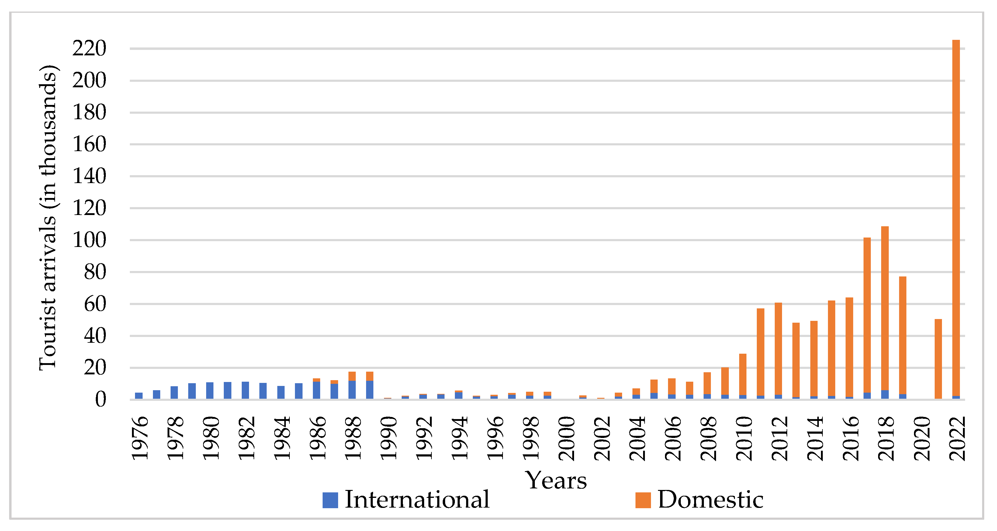
After Ladakh was opened to tourism in 1974, the new economic sector in Kargil grew gradually. After an increase in tourist arrivals from 4325 in 1976 to 17,501 in 1989, a drastic decline occurred from 1990 (1134 arrivals) until 2003 (4244), because Kargil was badly affected by the Kashmir conflict [99], which led to the Kargil war in 1999. An exponential growth in total tourist numbers, particularly in domestic tourists, can be detected after 2003, with a slight decrease in 2013 and 2014 (Figure 5). Since then, tourist numbers increased to 28,756 in 2010 and 108,532 in 2018. Between 2019 and 2021, tourist arrivals declined again, first because of the bifurcation of the Jammu and Kashmir state in 2019 [100] and then due to the COVID-19 lockdown and international travel restrictions in 2020 and 2021. The number of tourist arrivals in Kargil more than doubled in 2022 (225,543) compared to 2018. Compared to the domestic arrivals, the number of international tourists is on a lower level.
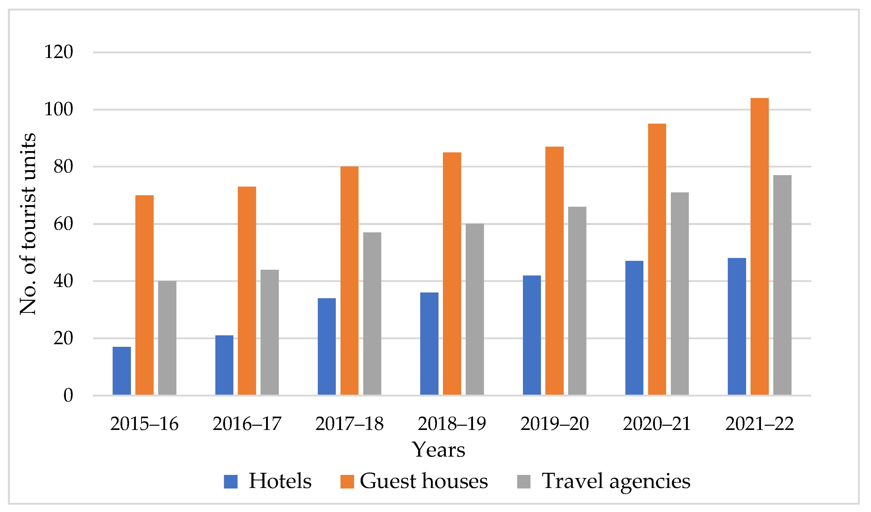
Because of the increase in tourists, the number of hotels more than doubled within seven years from 17 in 2015–2016 to 48 in 2021–2022, while the number of guesthouses increased only slightly from 70 in 2015–2016 to 104 in 2021–2022 (Figure 6). Similarly, the number of travel agencies increased from 40 to 77 between 2015–2016 and 2021–2022. A total of 21 tourist accommodation units were registered in 2021–2022. Tourism is one of the major factors in shaping and changing the urban landscape of this mountain town.
6. Discussion
This study shows that historical development, spatial expansion, population growth and tourism are the major driving factors in shaping and transforming the urban landscape of the mountain town of Kargil. The urban landscape started to transform rapidly, after the Kargil war and when Kargil was given the status of LAHDC-Kargil in 2003 [74]. The major factors have been population growth, rural to urban migration and employment opportunities in Kargil town. However, compared to the district of Leh, which has experienced a higher level of urbanisation (23%), the Kargil district was characterised by a much lower level of urbanisation (9%) in 2001 [101]. Similar to Leh [101,102], Kargil town has witnessed large migration from the surrounding villages, which puts immense pressure on the land and infrastructure of the town [96]. There are presently 10 private schools in addition to government public schools in Kargil town. The total number of state and national banks doubled from 13 to 29 between 2009–2010 and 2020–2021 [80,83].
The central town and the residential colonies are densely develped and have already started to surpass the carrying capacity. The urban encroachment and unplanned urban development to agricultural and barren areas, riverbanks and slopes led to increases in critical urban challenges, such as traffic congestion, solid wastes, sanitation and drainage problems. Many new administrative, commercial and residential buildings were constructed in Kurbathang plateau, where a new township has been proposed for urban development, including military compounds.
Similar to Leh town, it can be seen that urban growth is driven by infrastructure development, tourism, the administrative centre, urban culture and the geopolitical importance of the region [4]. In the case of Chitral town, urban development manifests in the expansion of the bazaar, residential areas and modern built-up areas with private and public services, largely driven by regional population growth, extensions of governmental administration and economic factors including mountain tourism [103,104]. The Himalayan mountain ecosystems are also going through a rapid transformation of their natural landscape and demographic profile due to economic development and rural to urban migration [1]. Urban expansion has emerged as a key driver of socioeconomic and environmental change, particularly in the context of the Himalayan mountain region [105].
Furthermore, there is high variability in the tourism sector and its dependence on geopolitical conflicts in Kargil. In contrast to Leh, most travellers on their route from Leh to Zanskar or Kashmir stay only for one night in Kargil. However, as in Leh, the increasing tourism sector results in drastic social changes and impacts on the land and environment [106].
7. Conclusions
Taking the case study of Kargil town, this article presents an overview of the current challenges of mountain urbanisation in Ladakh and provides potential lines of future applied and solution-oriented research work based on existing studies. There is an urgent need to implement robust urban planning mechanisms to tackle the existing and future problems of Kargil town. This includes a systematic approach to deal with the unregulated and unplanned haphazard development. The Ladakh Autonomous Hill Development Council Kargil (LAHDC-Kargil) and the administration of UT Ladakh need to take drastic decisions with respect to policy formulation, urban planning and the governance mechanism of Kargil town. Similarly, the municipal committee and urban local bodies need to focus more on planning norms and the enforcement of regulations to foster sustainable, equitable and inclusive urban and regional development in Ladakh. Urban dynamics are not only affecting local population and economic activities, but they are also transforming landscape structures.
Author Contributions
Conceptualisation, A.H. and M.N.; methodology, A.H.; software, A.H.; validation, A.H.; formal analysis, A.H.; investigation, A.H., S.S. and M.N.; resources, A.H. and S.S.; writing—original draft preparation, A.H. and S.S.; writing—review and editing, A.H., S.S. and M.N.; visualisation, M.N., A.H. and S.S.; supervision, M.N. and S.S.; project administration, M.N. and S.S.; funding acquisition, A.H. All authors have read and agreed to the published version of the manuscript.
Funding
This research was funded by the Ministry of Tribal Affairs, Government of India.
Data Availability Statement
Not applicable.
Acknowledgments
The first author is highly indebted to the Ministry of Tribal Affairs, Government of India, for providing a scholarship to conduct his Ph.D. at Heidelberg University, Germany. We would also like to thank USGS and PlanetScope (Planet) for providing satellite data. The authors gratefully acknowledge the data storage service SDS@hd supported by the Ministry of Science, Research and the Arts Baden-Württemberg (MWK) and the German Research Foundation (DFG) through grant INST 35/1314-1 FUGG and INST 35/1503-1 FUGG. We would further like to express our gratitude to all those people who helped us during data collection and field surveys. We also thank Nils Harm for improving the cartography. We are grateful to two anonymous reviewers for their constructive suggestions, which helped to improve the article.
Conflicts of Interest
The authors declare no conflict of interest.
References
- IHCAP. Urbanisation Challenges in the Himalayan Region in the Context of Climate Change Adaptation and Disaster Risk Mitigation; Indian Himalayan Climate Change Program (IHCAP): New Delhi, India, 2017. [Google Scholar]
- Ishtiaque, A.; Shrestha, M.; Chhetri, N. Rapid Urban Growth in the Kathmandu Valley, Nepal: Monitoring Land Use Land Cover Dynamics of a Himalayan City with Landsat Imageries. Environments 2017, 4, 72. [Google Scholar] [CrossRef]
- Tiwari, P.C.; Tiwari, A.; Joshi, B. Urban Growth in Himalaya: Understanding the Process and Options for Sustainable Development. J. Urban Reg. Stud. Contemp. India 2018, 4, 15–27. [Google Scholar]
- Dame, J.; Schmidt, S.; Müller, J.; Nüsser, M. Urbanisation and Socio-Ecological Challenges in High Mountain Towns: Insights from Leh (Ladakh), India. Landsc. Urban Plan. 2019, 189, 189–199. [Google Scholar] [CrossRef]
- Singh, S.; Tanvir Hassan, S.M.; Hassan, M.; Bharti, N. Urbanisation and Water Insecurity in the Hindu Kush Himalaya: Insights from Bangladesh, India, Nepal and Pakistan. Water Policy 2020, 22, 9–32. [Google Scholar] [CrossRef]
- Anees, M.M.; Sharma, R.; Joshi, P.K. Urbanization in Himalaya—An Interregional Perspective to Land Use and Urban Growth Dynamics. In Mountain Landscapes in Transition; Schickhoff, U., Singh, R.B., Mal, S., Eds.; Sustainable Development Goals Series; Springer International Publishing: Cham, Switzerland, 2022; pp. 517–538. ISBN 978-3-030-70237-3. [Google Scholar]
- Chao, Z.; Shang, Z.; Fei, C.; Zhuang, Z.; Zhou, M. Spatiotemporal Analysis of Urban Expansion in the Mountainous Hindu Kush Himalayas Region. Land 2023, 12, 576. [Google Scholar] [CrossRef]
- Anhorn, J.; Lennartz, T.; Nüsser, M. Rapid Urban Growth and Earthquake Risk in Musikot, Mid-Western Hills, Nepal. Erdkunde 2015, 69, 307–325. [Google Scholar] [CrossRef]
- Ehrlich, D.; Melchiorri, M.; Capitani, C. Population Trends and Urbanisation in Mountain Ranges of the World. Land 2021, 10, 255. [Google Scholar] [CrossRef]
- Bhandari, M. International Centre for Integrated Mountain Development. In The Wiley-Blackwell Encyclopedia of Globalization; Ritzer, G., Ed.; John Wiley & Sons, Ltd.: Chichester, UK, 2012; p. wbeog308. ISBN 978-0-470-67059-0. [Google Scholar]
- Wang, Y.; Wu, N.; Kunze, C.; Long, R.; Perlik, M. Drivers of Change to Mountain Sustainability in the Hindu Kush Himalaya. In The Hindu Kush Himalaya Assessment; Springer: Cham, Switzerland, 2019; pp. 17–56. [Google Scholar]
- Haack, B.N.; Rafter, A. Urban Growth Analysis and Modeling in the Kathmandu Valley, Nepal. Habitat Int. 2006, 30, 1056–1065. [Google Scholar] [CrossRef]
- Ziegler, A.D.; Cantarero, S.I.; Wasson, R.J.; Srivastava, P.; Spalzin, S.; Chow, W.T.L.; Gillen, J. A Clear and Present Danger: Ladakh’s Increasing Vulnerability to Flash Floods and Debris Flows: Tourism and Vulnerability to Floods. Hydrol. Process. 2016, 30, 4214–4223. [Google Scholar] [CrossRef]
- Schmidt, S.; Nüsser, M.; Baghel, R.; Dame, J. Cryosphere Hazards in Ladakh: The 2014 Gya Glacial Lake Outburst Flood and Its Implications for Risk Assessment. Nat. Hazards 2020, 104, 2071–2095. [Google Scholar] [CrossRef]
- Sekhri, S.; Kumar, P.; Fürst, C.; Pandey, R. Mountain Specific Multi-Hazard Risk Management Framework (MSMRMF): Assessment and Mitigation of Multi-Hazard and Climate Change Risk in the Indian Himalayan Region. Ecol. Indic. 2020, 118, 106700. [Google Scholar] [CrossRef]
- Hewitt, K.; Mehta, M. Rethinking Risk and Disasters in Mountain Areas. Rev. Géogr. Alp. 2012, 100, 1. [Google Scholar] [CrossRef]
- Bharti, N.; Khandekar, N.; Sengupta, P.; Bhadwal, S.; Kochhar, I. Dynamics of Urban Water Supply Management of Two Himalayan Towns in India. Water Policy 2020, 22, 65–89. [Google Scholar] [CrossRef]
- Müller, J.; Dame, J.; Nüsser, M. Urban Mountain Waterscapes: The Transformation of Hydro-Social Relations in the Trans-Himalayan Town Leh, Ladakh, India. Water 2020, 12, 1698. [Google Scholar] [CrossRef]
- Joshi, N. Adopting a Governance Lens to Address Urban Risks in the Uttarakhand Himalayas: The Case of Almora, India. Int. J. Disaster Risk Reduct. 2021, 54, 102044. [Google Scholar] [CrossRef]
- Müller, J. Urban Mountain Waterscapes in Leh, Indian Trans-Himalaya: The Transformation of Hydro-Social Relations; Advances in Asian Human-Environmental Research; Springer International Publishing: Cham, Switzerland, 2022; ISBN 978-3-031-18248-8. [Google Scholar]
- Chauhan, D.; Thiyaharajan, M.; Pandey, A.; Singh, N.; Singh, V.; Sen, S.; Pandey, R. Climate Change Water Vulnerability and Adaptation Mechanism in a Himalayan City, Nainital, India. Environ. Sci. Pollut. Res. 2022, 29, 85904–85921. [Google Scholar] [CrossRef] [PubMed]
- Tiwari, P.C.; Joshi, B. Challenges of Urban Growth in Himalaya with Reference to Climate Change and Disaster Risk Mitigation: A Case of Nainital Town in Kumaon Middle Himalaya, India. In Himalayan Weather and Climate and their Impact on the Environment; Dimri, A.P., Bookhagen, B., Stoffel, M., Yasunari, T., Eds.; Springer International Publishing: Cham, Switzerland, 2020; pp. 473–491. ISBN 978-3-030-29683-4. [Google Scholar]
- Thakur, P.K.; Kumar, M.; Gosavi, V.E. Monitoring and Modelling of Urban Sprawl Using Geospatial Techniques—A Case Study of Shimla City, India. In Geoecology of Landscape Dynamics; Sahdev, S., Singh, R.B., Kumar, M., Eds.; Advances in Geographical and Environmental Sciences; Springer: Singapore, 2020; pp. 263–294. ISBN 9789811520969. [Google Scholar]
- Sapru, C.S. District Census Handbook, Leh District, Part A & B, Series-2; Deputy Director of Census Operations: Leh, India, 2001. [Google Scholar]
- Dame, J.; Nüsser, M. Development Perspectives in Ladakh, Lndia. Geogr. Rundsch. Int. Ed. 2008, 4, 20–27. [Google Scholar]
- Nüsser, M.; Schmidt, S.; Dame, J. Irrigation and Development in the Upper Indus Basin: Characteristics and Recent Changes of a Socio-Hydrological System in Central Ladakh, India. Mt. Res. Dev. 2012, 32, 51–61. [Google Scholar] [CrossRef]
- Field, J. The Impact on Disaster Governance of the Intersection of Environmental Hazards, Border Conflict and Disaster Responses in Ladakh, India. Int. J. Disaster Risk Reduct. 2018, 31, 650–658. [Google Scholar] [CrossRef]
- Soheb, M.; Ramanathan, A.; Bhardwaj, A.; Sam, L. Spatiotemporal Quantification of Key Environmental Changes in Stok and Kang Yatze Regions of Ladakh Himalaya, India. Geocarto Int. 2022, 37, 11509–11533. [Google Scholar] [CrossRef]
- Dame, J.; Nüsser, M. Food Security in High Mountain Regions: Agricultural Production and the Impact of Food Subsidies in Ladakh, Northern India. Food Secur. 2011, 3, 179–194. [Google Scholar] [CrossRef]
- Geneletti, D.; Dawa, D. Environmental Impact Assessment of Mountain Tourism in Developing Regions: A Study in Ladakh, Indian Himalaya. Environ. Impact Assess. Rev. 2009, 29, 229–242. [Google Scholar] [CrossRef]
- Goeury, D. Ladakh, Kingdom of Sustainable Development? Rev. Géogr. Alp. 2010, 98, 109–121. [Google Scholar] [CrossRef]
- Adnan, M. The Kargil Crisis 1999 and Pakistan’s Constraints. J. Polit. Stud. 2015, 22, 129. [Google Scholar]
- Grist, N. Local Politics in the Suru Valley of Northern India. Ph.D. Thesis, Goldsmiths, University of London, London, UK, 1998. [Google Scholar]
- Hill, J. Farmer-Managed Irrigation Systems in Baltistan and Kargil. Ladakh Stud. 2014, 31, 4–23. [Google Scholar]
- Rizvi, J. Trans-Himalayan Caravans: Merchant Princes and Peasant Traders in Ladakh; Oxford India Paperbacks; Oxford Univ. Press: New Delhi, India, 2001; ISBN 978-0-19-565817-0. [Google Scholar]
- Fewkes, J.H. Trade and Contemporary Society along the Silk Road; Routledge: London, UK, 2008; ISBN 978-1-135-97309-4. [Google Scholar]
- Bhan, M. Border Practices: Labour and Nationalism among Brogpas of Ladakh. Contemp. South Asia 2008, 16, 139–157. [Google Scholar] [CrossRef]
- Gupta, R. Poetics and Politics of Borderland Dwelling: Baltis in Kargil. South Asia Multidiscip. Acad. J. 2014, 10, 1–18. [Google Scholar] [CrossRef]
- India Meteorological Department. Climate of Jammu and Kashmir; Governement of India: Pune, India, 2014; pp. 1–176. [Google Scholar]
- District Disaster Management Authority Kargil. District Disaster Management Plan Kargil; Ladakh Autonomous Hill Development Council: Kargil, India, 2017; pp. 1–34. [Google Scholar]
- Klimeš, L.; Dickoré, B. A Contribution to the Vascular Plant Flora of Lower Ladakh (Jammu & Kashmir, India). Willdenowia 2005, 35, 125. [Google Scholar] [CrossRef]
- Bates, R.; Harman, N. The Lost World of Ladakh–Early Photographic Journeys in the Indian Himalaya 1931–1934. Asian Highl. Perspect. 31; Stawa Publications: Leh, India, 2014. [Google Scholar]
- Deboos, S. Tourism Promotes the Folklorisation Process. The Case of Kargil and Zanskar Festival. In Proceedings of the III Simposio Internacional de Corpus, Cuerpos Y Folklore(s) Herencias, Construcciones Y Performencias, Lima, Peru, 21–23 October 2010; pp. 170–181. [Google Scholar]
- Bellew, H.W. Kashmir and Kashghar: A Narrative of the Journey of the Embassy to Kashghar in 1873–74; Trübner & Co.: London, UK, 1875. [Google Scholar]
- Duke, J. Kashmir and Jammu: A Guide for Visitors; Thacker, Spink & Co.: Calcutta, India, 1903. [Google Scholar]
- von Schlagintweit, H.; Schlagintweit, A.; Schlagintweit, R. Results of a Scientific Mission to India and High Asia; Trübner & Co.: London, UK, 1861; Volume 1. [Google Scholar]
- Neve, A. The Tourist’s Guide to Kashmir, Ladakh, Skardo, & C., 11th ed.; The Civil & Military Gazette Press: Lahore, India, 1918. [Google Scholar]
- Filippi, F.D. The Italian Expedition to the Himalaya, Karakoram and Eastern Turkestan (1913-1914); Edward Arnold and Co.: London, UK, 1931. [Google Scholar]
- Drew, F. The Jummoo and Kashmir Territories: A Geographical Account; Edward Stanford: London, UK, 1875. [Google Scholar]
- Duncan, J.E. A Summer Ride through Western Tibet; Smith, Elder & Company: London, UK, 1906. [Google Scholar]
- Rizvi, J. Ladakh: Crossroads of High Asia, 3rd ed.; Oxford University Press: New Delhi, India, 2012; ISBN 978-0-19-807941-5. [Google Scholar]
- Sheikh, A.G. Reflections on Ladakh, Tibet and Central Asia; Inamullah Abdulmatin: Leh, India, 2014. [Google Scholar]
- Gazetteer of Kashmir and Ladák; Together with Routes in the Territories of the Maharája of Jamú and Kashmír; compiled under the direction of the Quarter Master General in India in the Intelligence Branch; Superintendent of Government Printing: Calcutta, India, 1890.
- Gompertz, M.L.A. The Road to Lamaland: Impressions of a Journey to Western Thibet; Hodder & Stoughton Limited: London, UK, 1926. [Google Scholar]
- Cunningham, A. Ladák, Physical, Statistical, and Historical: With Notes of the Surrounding Countries; Wm. H. Allen and Company: London, UK, 1854. [Google Scholar]
- Moorcroft, W.; Trebeck, G. Travels in the Himalayan Provinces of Hindustan and the Panjab; in Ladakh and Kashmir; in Peshawar, Kabul, Kunduz and Bokhara; from 1819 to 1825; John Murray: London, UK, 1841; Volume ii. [Google Scholar]
- Adair, F.E.S.; Godfrey, S.H. A Summer in High Asia: Being a Record of Sport and Travel in Baltistan and Ladakh, with an Appendix on Central Asian Trade, Illustrated from Drawings by the Author, Photographs, and a Map of the Route; W. Thacker & Company: London, UK, 1899. [Google Scholar]
- Bray, J. Ladakhi History and Indian Nationhood. South Asia Res. 1991, 11, 115–133. [Google Scholar] [CrossRef]
- Kreutzmann, H. Accessibility for High Asia: Comparative Perspectives on Northern Pakistan’s Traffic Infrastructure and Linkages with Its Neighbours in the Hindukush-Karakoram-Himalaya. J. Mt. Sci. 2004, 1, 193–210. [Google Scholar] [CrossRef]
- Kreutzmann, H. Hunza Matters: Bordering and Ordering between Ancient and New Silk Roads; Harrasowitz: Wiesbaden, Germany, 2020; ISBN 978-3-447-11369-4. [Google Scholar]
- Demenge, J. The Political Ecology of Road Construction in Ladakh. Ph.D. Thesis, University of Sussex, Brighton, UK, 2011. [Google Scholar]
- Kreutzmann, H. Kashmir and the Northern Areas of Pakistan: Boundary-Making along Contested Frontiers. Erdkunde 2008, 62, 201–219. [Google Scholar] [CrossRef]
- Chand, R. Agricultural Development, Growth and Poverty in India’s Mountain Region. In Proceedings of the Growth, Poverty Alleviation and Sustainable Resource Management in the Mountain Areas of South Asia, Kathmandu, Nepal, 1 January–4 February 2000; International Centre for Integrated Mountain Development: Kathmandu, Nepal, 2000; pp. 275–291. [Google Scholar]
- Aggarwal, R. Beyond Lines of Control Performance and Politics on the Disputed Borders of Ladakh, India; Duke University Press: Durham, UK, 2004; ISBN 978-0-8223-8589-9. [Google Scholar]
- Wiley, A.S. The Ecology of Low Natural Fertility in Ladakh. J. Biosoc. Sci. 1998, 30, 457–480. [Google Scholar] [CrossRef]
- Vogel, B.; Field, J. (Re)Constructing Borders through the Governance of Tourism and Trade in Ladakh, India. Polit. Geogr. 2020, 82, 102226. [Google Scholar] [CrossRef]
- Baghel, R.; Nüsser, M. Securing the Heights: The Vertical Dimension of the Siachen Conflict between India and Pakistan in the Eastern Karakoram. Polit. Geogr. 2015, 48, 24–36. [Google Scholar] [CrossRef]
- Kapur, S.P. Ten Years of Instability in a Nuclear South Asia. Int. Secur. 2008, 33, 71–94. [Google Scholar] [CrossRef]
- Zins, M.-J. Public Rites and Patriotic Funerals: The Heroes and the Martyrs of the 1999 Indo-Pakistan Kargil War. India Rev. 2007, 6, 25–45. [Google Scholar] [CrossRef]
- Warikoo, K. Kargil Conflict View from Kashmir. Himal. Cent. Asian Stud. 1999, 3, 28–45. [Google Scholar]
- Field, J. Caught between Paper Plans and Kashmir Politics: Disaster Governance in Ladakh, India. Polit. Gov. 2020, 8, 355–365. [Google Scholar] [CrossRef]
- Bhan, M. Refiguring Rights, Redefining Culture: Hill-Councils in Kargil, Jammu and Kashmir. Sociol. Bull. 2009, 58, 71–93. [Google Scholar] [CrossRef]
- Beek, M. van Beyond Identity Fetishism: “Communal” Conflict in Ladakh and the Limits of Autonomy. Cult. Anthropol. 2000, 15, 525–569. [Google Scholar] [CrossRef]
- Bhan, M. Counterinsurgency, Democracy, and the Politics of Identity in India; Routledge: Abingdon, UK, 2013; ISBN 978-1-134-50983-6. [Google Scholar]
- Ashiq, P. Ladakh Gets Divisional Status; The Hindu. 8 February 2019. Available online: https://www.thehindu.com/news/national/other-states/ladakh-gets-divisional-status/article26217039.ece (accessed on 1 April 2023).
- Tiwary, D. Explained: Jammu and Kashmir State to Two UTs—Today, Later; Indian Express: New Delhi, India, 2019. [Google Scholar]
- Chowdhary, R. How Ladakhi Politics Changed—And Drove the Centre into a Corner; The Wire: New Delhi, India, 2023. [Google Scholar]
- Sharma, A. Ladakhis hold joint protest, demand statehood and safeguards under the Sixth Schedule. The Indian Express. 15 January 2023. Available online: https://indianexpress.com/article/political-pulse/ladakhis-hold-joint-protest-demand-statehood-and-safeguards-under-the-sixth-schedule-8383698/ (accessed on 1 April 2023).
- Census of India Primary Census 1961–2011. Available online: https://censusindia.gov.in/ (accessed on 1 April 2023).
- District Statistical & Evaluation Office Kargil. District Kargil at a Glance; Directorate of Econmomics & Statitics, Planning Development & Monitoring Department: Kargil, India, 2012. [Google Scholar]
- District Statistical & Evaluation Office Kargil. Statistical Handbook; Directorate of Econmomics & Statitics, Planning Development & Monitoring Department: Kargil, India, 2018. [Google Scholar]
- District Statistical & Evaluation Office Kargil. Statistical Handbook; Directorate of Econmomics & Statitics, Planning Development & Monitoring Department: Kargil, India, 2019. [Google Scholar]
- District Statistical & Evaluation Office Kargil. Statistical Handbook; Directorate of Econmomics & Statitics, Planning Development & Monitoring Department: Kargil, India, 2020. [Google Scholar]
- District Statistical & Evaluation Office Kargil. Statistical Handbook; Directorate of Econmomics & Statitics, Planning Development & Monitoring Department: Kargil, India, 2021. [Google Scholar]
- Abou EL-Magd, I.; Tanton, T.W. Improvements in Land Use Mapping for Irrigated Agriculture from Satellite Sensor Data Using a Multi-Stage Maximum Likelihood Classification. Int. J. Remote Sens. 2003, 24, 4197–4206. [Google Scholar] [CrossRef]
- Kantakumar, L.N.; Neelamsetti, P. Multi-Temporal Land Use Classification Using Hybrid Approach. Egypt. J. Remote Sens. Space Sci. 2015, 18, 289–295. [Google Scholar] [CrossRef]
- Mishra, P.K.; Rai, A.; Rai, S.C. Land Use and Land Cover Change Detection Using Geospatial Techniques in the Sikkim Himalaya, India. Egypt. J. Remote Sens. Space Sci. 2020, 23, 133–143. [Google Scholar] [CrossRef]
- Weslati, O.; Bouaziz, S.; Serbaji, M.M. Mapping and Monitoring Land Use and Land Cover Changes in Mellegue Watershed Using Remote Sensing and GIS. Arab. J. Geosci. 2020, 13, 687. [Google Scholar] [CrossRef]
- Thakkar, A.K.; Desai, V.R.; Patel, A.; Potdar, M.B. Post-Classification Corrections in Improving the Classification of Land Use/Land Cover of Arid Region Using RS and GIS: The Case of Arjuni Watershed, Gujarat, India. Egypt. J. Remote Sens. Space Sci. 2017, 20, 79–89. [Google Scholar] [CrossRef]
- Congalton, R.G.; Green, K. A Practical Look at the Sources of Confusion in Error Matrix Generation. Photogramm. Eng. Remote Sens. 1993, 59, 641–644. [Google Scholar]
- Hurskainen, P.; Adhikari, H.; Siljander, M.; Pellikka, P.K.E.; Hemp, A. Auxiliary Datasets Improve Accuracy of Object-Based Land Use/Land Cover Classification in Heterogeneous Savanna Landscapes. Remote Sens. Environ. 2019, 233, 111354. [Google Scholar] [CrossRef]
- Foody, G.M. Status of Land Cover Classification Accuracy Assessment. Remote Sens. Environ. 2002, 80, 185–201. [Google Scholar] [CrossRef]
- Kalkhan, M.A.; Reich, R.M.; Czaplewski, R.L. Variance Estimates and Confidence Intervals for the Kappa Measure of Classification Accuracy. Can. J. Remote Sens. 1997, 23, 210–216. [Google Scholar] [CrossRef]
- Landis, J.R.; Koch, G.G. The Measurement of Observer Agreement for Categorical Data. Biometrics 1977, 33, 159–174. [Google Scholar] [CrossRef]
- Pontius, R.G.; Millones, M. Death to Kappa: Birth of Quantity Disagreement and Allocation Disagreement for Accuracy Assessment. Int. J. Remote Sens. 2011, 32, 4407–4429. [Google Scholar] [CrossRef]
- Town Planning Organisation. Master Plan of Kargil. 2018, pp. 1–135. Available online: https://kargil.nic.in/document/draft-master-plan-kargil/ (accessed on 1 April 2023).
- Khan, K.A. The Unmaking of Kargil Town. Stawa. 2020. Available online: https://stawa.org/the-unmaking-of-kargil-town/ (accessed on 1 April 2023).
- Mankelow, J.S. The Implementation of the Watershed Development Programme in Zangskar, Ladakh: Irrigation Development, Politics and Society; University of London: London, UK, 2003. [Google Scholar]
- Grist, N. Urbanisation in Kargil and Its Effects in the Suru Valley. In Modern Ladakh; van Beek, M., Pirie, F., Eds.; Brill: Leiden, The Netherlands, 2008; pp. 77–100. ISBN 978-90-04-16713-1. [Google Scholar]
- Outlook Web Bureau. Amid Curfew in Kashmir, Indefinite Restrictions Imposed on Large Gatherings in Kargil. Outlook 8 August 2019. Available online: https://www.outlookindia.com/website/story/india-news-amid-curfew-in-kashmir-indefinite-restrictions-imposed-on-large-gatherings-in-kargil/335822 (accessed on 1 April 2023).
- Goodall, S.K. Rural-to-Urban Migration and Urbanization in Leh, Ladakh: A Case Study of Three Nomadic Pastoral Communities. Mt. Res. Dev. 2004, 24, 220–227. [Google Scholar] [CrossRef]
- Hussain, A. Ladakh and Town Planning. Available online: https://www.greaterkashmir.com/todays-paper/ladakh-and-town-planning (accessed on 29 April 2022).
- Nüsser, M. Understanding Cultural Landscape Transformation: A Re-Photographic Survey in Chitral, Eastern Hindukush, Pakistan. Landsc. Urban Plan. 2001, 57, 241–255. [Google Scholar] [CrossRef]
- Dittmann, A.; Nüsser, M. Siedlungsentwicklung Im Östlichen Hindukusch: Das Beispiel Chitral Town (North-West Frontier Province, Pakistan). Erdkunde 2002, 56, 60–72. [Google Scholar] [CrossRef]
- Wester, P.; Mishra, A.; Mukherji, A.; Shrestha, A.B. (Eds.) The Hindu Kush Himalaya Assessment: Mountains, Climate Change, Sustainability and People; Springer International Publishing: Cham, Switzerland, 2019; ISBN 978-3-319-92287-4. [Google Scholar]
- Pelliciardi, V. Factors Affecting International and National Tourist Arrivals (1974–2020) in Leh District (UT Ladakh, India). Eur. J. Sustain. Dev. 2021, 10, 736. [Google Scholar] [CrossRef]
Figure 1.
(A) Location of Kargil town in Ladakh and (B) detailed distribution of settlements and residential colonies of Kargil town (Source: PlanetScope (8 June 2020); SRTM (11 February 2000); OpenStreetMap).
Figure 1.
(A) Location of Kargil town in Ladakh and (B) detailed distribution of settlements and residential colonies of Kargil town (Source: PlanetScope (8 June 2020); SRTM (11 February 2000); OpenStreetMap).

Figure 2.
Photographs showing settlements of different areas in Kargil town. Top: Baroo and Baroo colony urban settlements along with cultivated fields at the upper part of Baroo on the opposite side of Suru River in August 2009 (A) and March 2023 (B). Middle: urban structure of Kargil town at the junction of Suru and Wakha rivers (C) and Andoo colony on steep slope area (D). Bottom: local bazaar of old town (E) and along National Highway-301 (F). Photos—(A): Susanne Schmidt, August 2009, (B): Marcus Nüsser, March 2023; (C–E): Altaf Hussain, August and September 2021, 2022, (F): Susanne Schmidt, March 2023.

Figure 3.
Establishment of new residential colonies and army areas (Source: PlanetScope (8 June 2020); draft and cartography: Altaf Hussain).
Figure 3.
Establishment of new residential colonies and army areas (Source: PlanetScope (8 June 2020); draft and cartography: Altaf Hussain).

Figure 4.
Land use and land cover (LULC) maps of Kargil town from 1965 to 2020.

Figure 5.
International and domestic tourist arrivals in Kargil, Ladakh from 1976 to 2022 (Source: District Tourism Department of Kargil, Union Territory of Ladakh).
Figure 5.
International and domestic tourist arrivals in Kargil, Ladakh from 1976 to 2022 (Source: District Tourism Department of Kargil, Union Territory of Ladakh).

Figure 6.
Total number of hotels, guest houses and travel agencies in Kargil, Ladakh (Source: District Tourism Department of Kargil, Union Territory of Ladakh).
Figure 6.
Total number of hotels, guest houses and travel agencies in Kargil, Ladakh (Source: District Tourism Department of Kargil, Union Territory of Ladakh).


Table 1.
Details of satellite datasets used in the study.
| Satellite | Acquisition Date | Scene ID | Spatial Resolution (m) | Spectral Bands | Source |
|---|---|---|---|---|---|
| Corona | 8 October 1965 | DS1025-1039DA025_c | 2 | pan | USGS |
| Corona | 17 June 1979 | DZB1215-500431L009001_b | 3 | pan | USGS |
| ASTER | 4 September 2000 | AST_L1T_00309042000060203_20150411131129_5580 | 15 + 30 | VNIR/SWIR | USGS |
| PlanetScope | 8 June 2020 | 20200608_032410_1052_3B_AnalyticMS 20200608_032411_1052_3B_AnalyticMS | 3 | VIS/NIR | PlanetScope |
| SRTM | 11 February 2000 | N34_E075 to N34_E077, N33_E075 to N33_E077 | 30 | C-band | USGS |
Table 2.
Description of land use and land cover class in the study area.
| Class | Class Description |
|---|---|
| Built-up area (BU) | Residential, commercial, and administrative areas, army compounds and other buildings |
| Irrigated land and vegetation (ILV) | Cultivated fields, lucerne (alfalfa), poplars, willows, fruit trees, meadows and grassland |
| Barren area (BA) | Barren soils, slope areas without vegetation and sediment deposits at river banks |
Table 3.
Accuracy assessment of land use and land cover (LULC) detection of Kargil town in 1965, 1979, 2000 and 2020.
Table 3.
Accuracy assessment of land use and land cover (LULC) detection of Kargil town in 1965, 1979, 2000 and 2020.
| Reference Data (%) | CE | OE | PA | UA | |||||
|---|---|---|---|---|---|---|---|---|---|
| Classified Data (%) | BU | ILV | BA | Total | (%) | (%) | (%) | (%) | |
| 1965 | BU | 21.4 | 0 | 0 | 7.32 | 0 | 78.6 | 21.4 | 100 |
| ILV | 45.3 | 84.4 | 0 | 37.40 | 41.3 | 15.6 | 84.4 | 58.7 | |
| BA | 33.3 | 15.6 | 100 | 55.28 | 27.9 | 0 | 100 | 72.1 | |
| OA | 69.1 | ||||||||
| KC | 0.53 | ||||||||
| 1979 | BU | 33.3 | 0 | 0 | 10.2 | 0 | 66.67 | 33.3 | 100 |
| ILV | 28.8 | 91.7 | 0 | 34.3 | 25.7 | 8.33 | 91.7 | 74.3 | |
| BA | 37.9 | 8.3 | 100 | 55.5 | 25 | 0 | 100 | 75 | |
| OA | 77.3 | ||||||||
| KC | 0.65 | ||||||||
| 2000 | BU | 79.5 | 0 | 1 | 24.2 | 1.5 | 20.5 | 79.5 | 98.5 |
| ILV | 11.2 | 100 | 0.2 | 36.9 | 9.3 | 0 | 100 | 90.8 | |
| BA | 9.3 | 0 | 98.8 | 38.9 | 7.1 | 1.2 | 98.8 | 92.9 | |
| OA | 93.5 | ||||||||
| KC | 0.9 | ||||||||
| 2020 | BU | 92.3 | 0 | 0 | 36.1 | 0 | 7.7 | 92.3 | 100 |
| ILV | 7.7 | 100 | 0 | 36.1 | 8.4 | 0 | 100 | 91.6 | |
| BA | 0 | 0 | 100 | 27.8 | 0 | 0 | 100 | 100 | |
| OA | 96.9 | ||||||||
| KC | 0.95 | ||||||||
BU: built-up area, ILV: irrigated land and vegetation, BA: barren area, CE: commission error, OE: omission error, PA: producer’s accuracy, UA: user’s accuracy, OA: overall accuracy, KC: Kappa coefficient.
Table 4.
Percentage and square kilometre of land use and land cover (LULC) in 1965, 1979, 2000 and 2020 and their changes.
Table 4.
Percentage and square kilometre of land use and land cover (LULC) in 1965, 1979, 2000 and 2020 and their changes.
| LULC Area in km2 (%) | LULC Changes in km2 (%) | |||||||
|---|---|---|---|---|---|---|---|---|
| 1965 | 1979 | 2000 | 2020 | 1965–1979 | 1979–2000 | 2000–2020 | 1965–2020 | |
| BU | 0.25 (1.3%) | 0.43 (2.2%) | 1.11 (5.7%) | 2.30 (11.7%) | 0.18 (0.9%) | 0.68 (3.5%) | 1.19 (6.0%) | 2.05 (10.4%) |
| ILV | 4.51 (23.0%) | 4.88 (24.8%) | 8.18 (41.6%) | 8.56 (43.6%) | 0.37 (1.8%) | 3.30 (16.8%) | 0.38 (2.0%) | 4.05 (20.6%) |
| BA | 14.88 (75.8%) | 14.33 (73.0%) | 10.35 (52.7%) | 8.78 (44.7%) | −0.55 (−2.8%) | −3.98 (−20.3%) | −1.57 (−8.0%) | −6.10 (−31.1%) |
Source: Corona (8 October 1965), Corona (17 June 1979), ASTER (4 September 2000) and PlanetScope (8 June 2020).
Table 5.
Town population, town decadal growth rate, level of urbanisation and population of Kargil district and Ladakh.
Table 5.
Town population, town decadal growth rate, level of urbanisation and population of Kargil district and Ladakh.
| Years | Kargil Town Population | Town Decadal Growth Rate (%) | Level of Urbanisation (%) | District Population | Ladakh Population |
|---|---|---|---|---|---|
| 1961 | 1681 | - | 3.7 | 45,064 | 88,651 |
| 1971 | 2390 | 42.2 | 4.5 | 53,400 | 105,291 |
| 1981 | 3527 | 47.5 | 5.3 | 65,992 | 134,372 |
| 1991 * | 6074 | 72.1 | 6.8 | 89,334 | 179,410 |
| 2001 | 10,657 | 75.4 | 8.9 | 119,307 | 236,539 |
| 2011 | 16,338 | 53.3 | 11.6 | 140,802 | 274,289 |
Source: Census of India (1961, 1971, 1981, 2001, 2011) [79]: Note: * The 1991 Census was not held in Jammu and Kashmir. Hence, the population figures for 1991 of Kargil town were interpolated by the author with the help of a linear projection method.
Disclaimer/Publisher’s Note: The statements, opinions and data contained in all publications are solely those of the individual author(s) and contributor(s) and not of MDPI and/or the editor(s). MDPI and/or the editor(s) disclaim responsibility for any injury to people or property resulting from any ideas, methods, instructions or products referred to in the content. |
© 2023 by the authors. Licensee MDPI, Basel, Switzerland. This article is an open access article distributed under the terms and conditions of the Creative Commons Attribution (CC BY) license (https://creativecommons.org/licenses/by/4.0/).
Share and Cite
MDPI and ACS Style
Hussain, A.; Schmidt, S.; Nüsser, M. Dynamics of Mountain Urbanisation: Evidence from the Trans-Himalayan Town of Kargil, Ladakh, India. Land 2023, 12, 920. https://doi.org/10.3390/land12040920
AMA Style
Hussain A, Schmidt S, Nüsser M. Dynamics of Mountain Urbanisation: Evidence from the Trans-Himalayan Town of Kargil, Ladakh, India. Land. 2023; 12(4):920. https://doi.org/10.3390/land12040920
Chicago/Turabian StyleHussain, Altaf, Susanne Schmidt, and Marcus Nüsser. 2023. "Dynamics of Mountain Urbanisation: Evidence from the Trans-Himalayan Town of Kargil, Ladakh, India" Land 12, no. 4: 920. https://doi.org/10.3390/land12040920
Note that from the first issue of 2016, this journal uses article numbers instead of page numbers. See further details here.