Article

Utilization Quality Evaluation and Barrier Factor Diagnosis of Rural Residential Areas in Agricultural Regions of the Northeast Plain: A Case Study of Wangkui County, Heilongjiang Province, China

School of Public Administration and Law, Northeast Agricultural University, Harbin 150030, China
*
Author to whom correspondence should be addressed.
Land 2023, 12(4), 870; https://doi.org/10.3390/land12040870
Submission received: 29 March 2023 / Revised: 8 April 2023 / Accepted: 10 April 2023 / Published: 12 April 2023
(This article belongs to the Special Issue Agricultural Land Use and Rural Development)

Abstract

:
Conducting quality evaluations of rural residential areas and effectively improving their utilization levels is an important aspect of correctly handling the relationship between humans and the land and achieving high-quality rural developments. Taking Wangkui County, Heilongjiang Province, as an example, this study aimed to achieve the “intensive, humanistic, and green” development of rural residential areas. An evaluation index system of utilization quality was constructed using three aspects: intensive land utilization, human settlement environment quality, and ecological environment quality. The comprehensive evaluation results were classified using a multidimensional combination matrix and targeted optimization plans were proposed. Additionally, an obstacle diagnosis model was constructed to identify the factors that hinder the high-quality utilization of rural residential areas. The results demonstrated the following: (1) The utilization quality of the rural residential areas in the study area was mainly at a medium level, followed by low and high levels, with proportions of 20.18%, 51.38%, and 28.44%, respectively. The utilization levels gradually decreased from the town centers to the surrounding areas. (2) Based on the evaluation results, there were 23 combinations of rural residential areas in the study area, which were classified into four types: coordinated control, key development, single leading, and transforming and upgrading. Optimization plans were proposed for the different types. (3) From the perspective of identifying the barrier factors, the top five factors that hindered the high-quality utilization of rural residential areas were the traffic land density, aggregation index, green-coverage rate of built-up areas, completeness of public service facilities, and the proportion of secondary and tertiary industrial land area. This study provides a significant reference for the evaluation of the utilization quality of rural residential areas in plain agricultural regions to effectively raise their levels of intensive land utilization, improve their settlement environments, enhance their ecological quality, and achieve a development of high quality.

1. Introduction

Rural residential areas are the basic supporting units of production and living conditions within the rural-area system, and they are important carriers for rural development [1]. For a long time, the layouts of the rural residential areas in China were mostly formed out of independent choices, showing an overall state of disorderly development and lacking scientific planning and guidance, which has resulted in a significant waste of land resources and a low degree of intensive utilization [2,3]. At the same time, there are obstacles to this development, such as the scarcity of public service facilities and infrastructures, as well as an urgent need to enhance production conditions [4,5]. In addition, a series of problems affect the high-quality use of rural residential areas. For example, the environmental pressure brought about by agricultural production has become increasingly prominent [6]. To change the current situation of rural settlement areas and improve their levels of utilization, China introduced a series of policies. In 2017, the concept of high-quality development was officially proposed in the report of the 19th National Congress of the Communist Party of China, emphasizing “quality as the foundation for building a strong country” and “quality-driven transformation”. In 2021, the Central Committee of the Communist Party of China and the State Council released the “Opinions on Promoting Rural Revitalization and Accelerating Agricultural and Rural Modernization”, which pointed out the need to promote high-quality developments, accelerate agricultural and rural modernization, improve the living environment, and enhance the rural ecological environment. During the 14th Five-Year Plan period, China will adhere to the theme of high-quality development and use it as a measure to promote various aspects of economic and social development. This indicates that, against this background, the development of rural residential areas also presents a valuable orientation of the project of high-quality utilization by adhering to the goal of achieving “land conservation and intensive use, comfortable and convenient living for residents, and healthy and sustainable ecological environment”. However, there is a significant gap between the current problems of rural residential areas and the requirements for achieving a high-quality development. As an important grain production area, the plain agricultural regions in our country urgently demand the high-quality utilization of rural residential areas to ensure agricultural production and the efficient utilization of land resources. Therefore, researching the utilization-quality evaluation of rural residential areas in the Northeast Plain agricultural area is beneficial for scientifically and quantitatively describing their utilization statuses; the rational allocation of development factors, such as rural land, population, and industry; and the correct handling of the relationship between humans and the land. This research provides a reference and technical support for achieving the high-quality utilization and sustainable development of rural residential areas.
In recent years, scholars at home and abroad have conducted a large amount of research to achieve the optimal development of rural residential areas. Based on multiple perspectives including geography [7], sociology [8], economics [9,10], and ecology [11], foreign scholars have studied the impact of factors such as landform characteristics, rural economy, population mobility, and environmental governance on the development of rural residential areas. This also guides scholars to pay attention to the optimization and utilization of rural residential areas from a multidisciplinary perspective. Domestic scholars have conducted extensive research on intensive-utilization evaluation [12,13,14], human-habitat-quality evaluation [15,16,17], ecological-suitability evaluation [18,19,20], and other aspects, to achieve the optimal development of rural residential areas. Starting from the perspectives of land use [21], location conditions [22], production and living accessibility [23], the ecological environment [24], policy conditions [25], and other aspects, and combining various natural, economic, social, and other factors, they used the entropy-weighting method [26], the analytic-hierarchy process [27], the factor-analysis method [28], among others, to construct evaluation index systems. They classified and organized villages based on the evaluation results, and then proposed targeted optimization strategies. In the new era of China’s entry onto the stage of high-quality development, research on utilization quality was also launched in various fields; however, recent studies mainly focused on the “quality of cultivated land utilization” [29], the “quality of construction land utilization” [30], etc. In the exploration of land-use quality, scholars such as Fang [31] and Wu [32] conducted research based on multidimensional data to achieve the high-quality utilization of the entire land space. Rural residential areas are an important type of territorial space; however, there has been relatively little research on their utilization quality. The development of rural residential areas is no longer limited to layout optimization but now also pays more attention to the development’s quality. The scholar Qu [33] defined the connotation of the utilization quality of rural residential areas from the perspective of the relationship between people and the land, and then proposed key points to focus on to enhance it. It can be said that evaluating the utilization quality from the perspective of rural residential areas is an extension and refinement of the land-use quality that can guide their efficient utilization.
Previous studies on the evaluation of rural residential areas by scholars mostly focused on factors such as comprehensive resource endowment and village consolidation losses, and they chose the reduction of the number of rural residential areas as the evaluation goal. They ignored the development quality of rural residential areas and rarely considered the comprehensive aspects of land utilization, living conditions, and the ecological environment. On the other hand, the evaluation of the utilization quality of rural residential areas aims to guide and improve the quality of rural settlements. This study emphasized the coordinated development of the multiple functions—such as production, settlement, and ecological services—that rural residential areas can provide. In addition, previous studies mainly focused on ecologically vulnerable areas [34], typical mountainous areas [35], etc.; however, the rural residential areas in China are widely distributed in the plain regions [36], where the terrain is flat and the main task is grain production. The existing problems in the utilization of rural residential areas cause substantial difficulties in ensuring agricultural production, farmers’ livelihoods, and rural ecology. We must urgently establish a scientific evaluation system to improve the utilization quality of the rural residential areas in the plain agricultural regions.
Based on the above, this study took the 109 administrative villages in Wangkui County, Heilongjiang Province, which is a typical agricultural area on the Northeast Plain, as the research area. The study aimed to improve the utilization quality of rural residential areas and guide their development in the direction of intensification, humanization, and greening, and it used a multifactor, comprehensive evaluation method to construct an evaluation index system to assess the degree of intensive land utilization, human settlement environment quality, and ecological environment quality. Next, we coded and combined the evaluation results and used the multidimensional combination matrix to classify the types of rural residential areas, and we then proposed suggestions for the different types. In addition, we used the obstacle diagnosis model to identify the main obstacle factors. This study aimed to provide support and a reference for the high-quality utilization of rural residential areas in the plain regions.

2. Materials and Methods

2.1. Study Area

Wangkui County is under the jurisdiction of the city of Suihua, Heilongjiang Province, and is one of the main typical areas of agricultural production on the Northeast China Plain. Its geographical range is between 126°10′–126°59′ E and 46°32′–47°28′ N. The region has a temperate continental monsoon climate, with a higher elevation in the northeast and lower elevation in the southwest. The total area of Wangkui County is 231656.96 hectares, which includes 10 towns and 5 townships, with 109 administrative villages. At the end of 2019, the total population of the county was 442,900, including 369,100 members of the agricultural population. Wangkui County is an important producer of commodity grain, with a cultivated area of 186,856.52 hectares, accounting for 80.66% of the total land area. In 2019, the agricultural output value of Wangkui County was CNY 357.7 million, accounting for 47.85% of the total output value of the agriculture, forestry, animal husbandry, and fishery industries in the county. The high dependence of farmers’ income on the agricultural production space highlights the importance of land resources for rural development in Wangkui County. In addition, there are long-standing problems in the layout and land use of the rural residential areas in Wangkui County, with a per capita rural residential land area of about 280.31 square meters, and prominent tensions between the people and the land. In recent years, Wangkui County has actively carried out village planning and preparation work; however, it urgently needs a scientific basis for planning from the perspective of high-quality utilization to improve the level of intensive land utilization, the living conditions of the villagers, and the ecological environment, to achieve the high-quality utilization of the rural residential areas and implement a strategy of rural revitalization and development. The study area is shown in Figure 1.

2.2. Data Source and Pretreatment

The data used in this study included land-use data, remote sensing image data, and socioeconomic data. The land-use data were obtained from the third national land survey database in 2018. The remote sensing image data were acquired from the high-resolution Satellite 2 in June 2019, with a spatial resolution of 1 m × 1 m. The socioeconomic data were sourced from the Heilongjiang Statistical Yearbook of 2019 and the Wangkui County Statistical Yearbook of 2019. The rest of the data was obtained through field surveys.
The data preprocessing included six steps. First, the extraction of rural residential areas was achieved using ArcGIS 10.2 software. Through visual interpretation, the boundaries of rural residential areas were redrawn based on the color, shape, and texture of the patches of rural residential areas presented in the high-resolution Satellite 2 in June 2019. The redrawn rural residential areas’ patch boundary data were overlaid with land-use data from the third national land survey database. Modifications were made to improve the interpretation accuracy by referring to the remote sensing images to address boundary inaccuracies. We then obtained data on the rural residential areas. Second, ArcGIS10.2 software was utilized to extract information on the cultivated land, residential land, idle land, road traffic land, secondary and tertiary industrial land, and ecological land. The near tools in ArcGIS were used to obtain data on the accessibility of the central towns. Third, the extracted rural-residential-area data were transformed into raster data, and FragStats 4.2 software was used to calculate the aggregation index and landscape shape index of the rural residential areas. Fourth, the data on the completeness of public service facilities were obtained through field surveys and interviews with village cadres to understand the construction situation of public service facilities in the village. The number of public service facilities, such as schools, clinics, libraries, cultural squares, shops, and others, was calculated by taking into account feedback from village cadres and conducting field surveys. The statistical results were then categorized into different levels and assigned corresponding scores. Fifth, the data on the amounts of pesticide, fertilizer, and agricultural plastic film usage were provided by the Wangkui County Statistics Bureau. Finally, based on the various obtained data, a unified summary analysis was conducted to construct a utilization-quality evaluation database of the rural residential areas for the study area.

2.3. Explanation of the Utilization-Quality Connotation

The utilization quality of rural residential areas refers to the degree of the quality of their utilization. Under the premise of complying with their natural attributes and development laws, rural residential areas are efficiently developed and utilized to better meet people’s needs. In the era of high-quality developments, the construction of rural residential areas should be based on the requirements of “intensification, humanization, and greening”. Intensified developments can promote improvements in the land-use efficiency and conservation of precious land resources. Humanized development focuses on the people’s pursuit of a better life, and it improves production and living conditions. Green development highlights ecological civilization constructions and places higher demands on ecological livability. Based on this, the evaluation of the utilization quality of the rural residential areas was conducted in terms of three aspects, namely, intensive land utilization, human settlement environment quality, and ecological environment quality, to comprehensively measure their utilization quality levels and achieve the maximization of economic, social, and ecological benefits.

2.4. Research Methods

2.4.1. Evaluation of Utilization Quality of Rural Residential Areas

Based on the understanding of the utilization quality of rural residential areas and the perspectives of “intensive, humanistic, and green” development, and with reference to relevant research on evaluation indicators [37,38,39,40], combined with the actual situation of the study area, the utilization-quality evaluation index system of the rural residential areas was constructed in terms of three aspects: intensive land utilization, human settlement environment quality, and ecological environment quality (Table 1).
Intensive land utilization reflects the characteristics of the land-use scale, layout, and structure in rural residential areas, and it mainly comprises five indicators: the per capita rural residential area, the aggregation index, the landscape-shape index, the proportion of residential-land area, and the proportion of idle-land area. Among them, the per capita rural residential area reflects the per capita land-use scale of the village. The larger the value, the lower the degree of intensive land utilization. The aggregation index reflects the degree of aggregation of rural residential areas. The larger the aggregation index, the higher the degree of aggregation. The landscape-shape index reflects the complexity of the spatial forms of rural residential areas. The larger the value, the more complex the shape of the rural residential area and the lower the degree of intensive utilization. The proportion of residential-land area reflects the proportion of residential land in the total area of the rural residential areas, which reflects the scale of the village residents’ living areas. The larger the scale, the better the land-use condition. The proportion of idle-land area reflects the proportion of idle land in the total area of rural residential areas. The larger the proportion of idle land, the more unreasonable the land use.
The human settlement environment quality reflects the degree of excellence of the production and life services available to the villagers, and it mainly comprises five indicators: traffic land density, completeness of public service facilities, accessibility of central towns, land-cultivation rate, and proportion of secondary and tertiary industrial land area. Among them, the traffic land density reflects the degree of accessibility of the road traffic in the villages. The more developed the traffic, the more convenient the living conditions of the villagers. The completeness of public service facilities reflects the level of supporting public service facilities in the village, representing the conditions of rural education, medical care, and other factors. The accessibility of central towns reflects the distance between the rural residential areas and the central towns. The closer to the central towns, the better the location conditions of the village and the greater the role played by the economic growth driven by urban development. The land-cultivation rate reflects the proportion of cultivated land in the village area, representing the levels of agricultural development space and land resources in the village. The proportion of secondary and tertiary industrial land area reflects the level of development of secondary and tertiary industries in the village, with larger values indicating better conditions of industrial development.
The ecological environment quality reflects the ecological resources and environmental conditions of villages, and it mainly comprises five indicators: green-coverage rate of the built-up areas, proportion of ecological land area, intensity of pesticide use, intensity of fertilizer use, and intensity of agricultural plastic film use. Among them, the green-coverage rate of the built-up areas reflects the degree of greening and coverage of rural residential areas. The higher the green-coverage rate, the more beautiful the ecological environment. The proportion of ecological land area reflects the proportion of ecological space and the natural resource endowment status of the village. The intensities of pesticide use, fertilizer use, and agricultural plastic film use reflect the amounts of pesticides, fertilizers, and plastic films used in the village, respectively, and represent the ecological environmental pressure brought about by the village’s agricultural production. The larger the numerical value, the more severe the environmental pollution.
To eliminate the dimensional differences within the index system, the raw data were normalized using Formulas (1) and (2):
Positive   Indicator :   X ij = X I J min ( X i ) max ( X i ) min ( X i )
Negative   Indicator :   X ij = max ( X i ) X I J max ( X i ) min ( X i )
where X ij is the standardized index value, X I J is the original value of the index, max ( X i ) is the maximum value of the index, and min ( X i ) is the minimum value of the index.
To avoid the interference of subjective factors in the evaluation results, after normalization, the entropy weight method [26] was adopted to find the entropy value and difference coefficient, and the index weight was calculated. Finally, the utilization-quality scores of the rural residential areas were calculated according to the multifactor comprehensive evaluation method. The related Formulas (3) to (6) are given below:
P ij = X ij m n X ij
e j = k i = 1 n P i j ln ( P i j )
W i j = ( 1 e j ) j = 1 n ( 1 e j )
S i j = j = 1 n X i j W i j
where n is the number of indicators (a total of 15 indicators were selected in this study), P i j is the weight of the i-th village under the j-th index, e j is the entropy value of the j-th index, W i j is the weight of each indicator, and S i j is the evaluation score of the utilization quality of the rural residential areas. According to the evaluation results, the natural breakpoint method in ArcGIS software was used to divide the intensive land utilization, human settlement environment quality, and ecological environment quality and the utilization quality of the rural residential areas into three levels of high, medium, and low, which were used to analyze their comprehensive utilization.

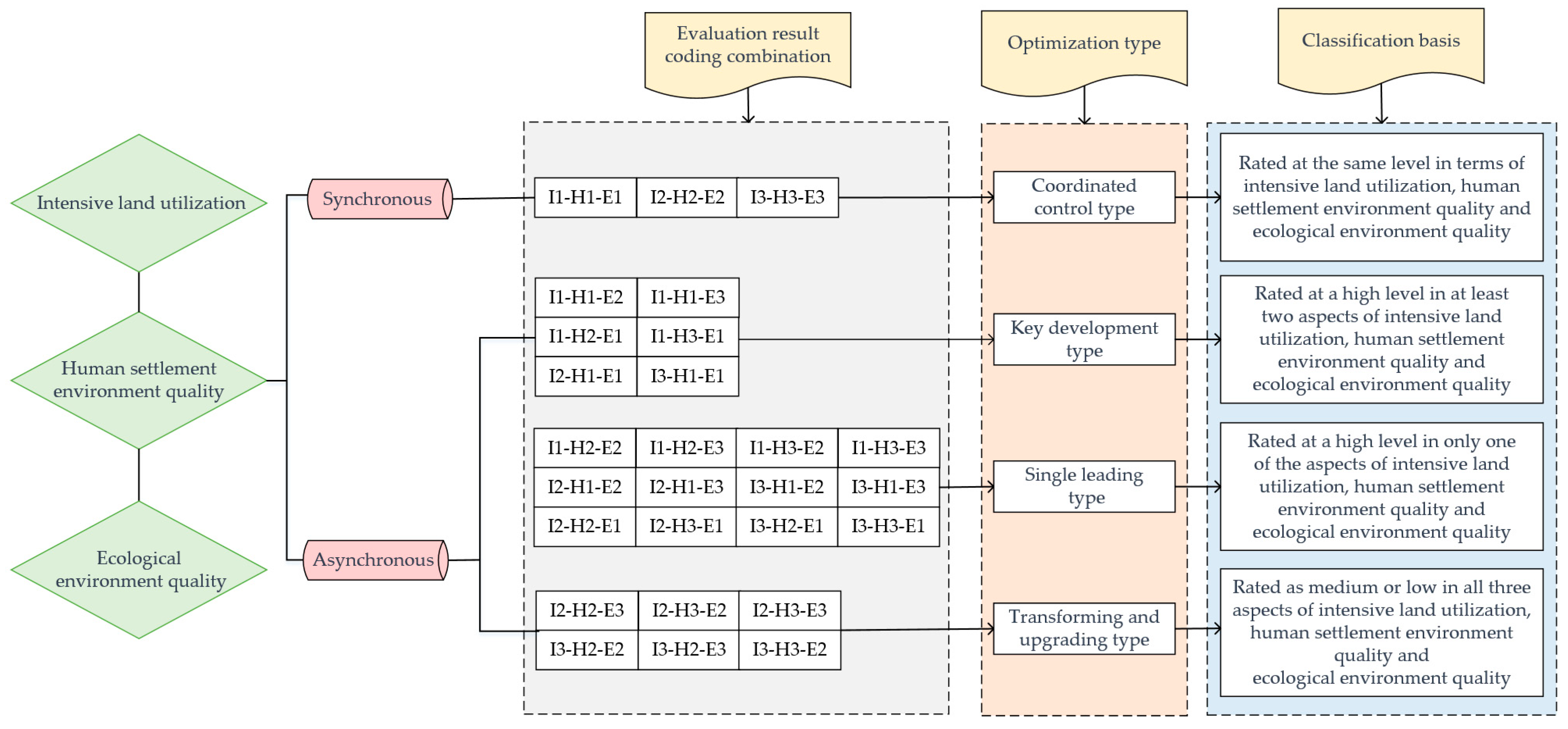
2.4.2. Classification of Rural Settlement Areas

Based on the evaluation results, the multidimensional combination matrix [41] was used to classify the rural settlement area types according to three aspects: intensive land utilization (I), human settlement environment quality (H), and ecological environment quality (E). The intensive land utilization, human settlement environment quality, and ecological environment quality were divided into high, medium, and low levels based on their numerical values, where 1 represented a high level, 2 represented a medium level, and 3 represented a low level. For example, a type with high intensive land utilization, medium human settlement environment quality, and low ecological environment quality was represented by the code I1-H2-E3. This provides a clear judgment of the specific utilization quality of rural settlement areas. The optimization types of rural residential areas followed the principles of discerning whether the development of intensive land utilization, human settlement environment quality, and ecological environment quality are synchronous. According to the discrimination principles, if the three aspects developed synchronously and were all at the same level, then this was classified as the coordinated-control type. If the development levels of the three aspects were not synchronous and two or more of them were at a high level, then this was classified as the key-development type. If only one aspect was at a high level, then this was classified as the single-leading type. If all three aspects were at a low or medium level, then this was classified as the transforming-and-upgrading type. Finally, optimization schemes were proposed based on the different types of rural residential areas (Figure 2).

2.4.3. Diagnosis of Obstacle Factors

Based on the quality evaluation of the rural residential areas, an obstacle diagnosis model was constructed, and the deviation, factor contribution, and obstacle degrees were introduced for analysis. The main and secondary relationships of the influencing factors were determined by ranking the obstacle degrees [42]. The larger the obstacle degree value, the higher the degree of constraint on the high-quality utilization of rural residential areas. The related Formula (7) is shown below:
H i j = U i j W i j j = 1 n U i j W i j
where U i j is the index deviation degree; U i j = 1 X i j is the difference between the standardized value of the single-index factor and the target value of 100%; X i j is the standardized value of the i-th index; n is the number of evaluation indicators; W i j is the weight of the i-th index; and H i j is the obstacle degree.

3. Results

3.1. Analysis of the Utilization Quality of Rural Residential Areas

3.1.1. Diagnosis of Obstacle Factors

The scores of the intensive utilization of the rural residential areas in Wangkui County ranged from 0.2163 to 0.8534. As shown in Figure 3a, the numbers of high-, medium-, and low-level rural residential areas in the study area were 37, 49, and 23, respectively, accounting for 33.94%, 44.95%, and 21.10%, respectively. Spatially, the rural residential areas with a high intensive utilization were mainly concentrated around the Wangkui County urban area, including Wangkui Town and the southwest of Xiangbaimanzu Township. These areas had obvious locational advantages, were strongly influenced by the development of the central urban area, had high levels of human and material inputs, and had a good degree of land-use intensification. The rural residential areas with a medium intensive utilization were mainly distributed in the southern and eastern parts of Wangkui County, including Huqimanzu Town and Weixing Town, etc. These areas had average levels of socioeconomic development, their locational advantages were not obvious, and their land-use patterns were extensive. The rural residential areas with a low intensive utilization were mainly distributed in the northwest and southeast, including Xianfeng Town and Haifeng Town, etc. These areas made excessive use of the per capita residential land and had large village areas, high proportions of idle land, and low levels of land-use intensification.

3.1.2. Analysis of the Human Settlement Environment Quality of Rural Residential Areas

The scores of the living-environment quality of the rural residential areas in Wangkui County ranged from 0.1998 to 0.7887. As shown in Figure 3b, the numbers of high-, medium-, and low-level rural residential areas in the study area were 12, 41, and 56, respectively, accounting for 11.01%, 37.61%, and 52.38%, respectively. Spatially, the rural residential areas with a high settlement-environment quality were mainly concentrated in the villages where the township governments were located, with high accessibility, complete supporting public service facilities, and high suitability for population living. The rural residential areas with a medium settlement-environment quality were mostly concentrated in the middle of Wangkui County, including Xiangbaimanzu Township and Dengta Town, etc. These areas were mainly developed for agriculture, with high rates of land cultivation; however, the development of secondary and tertiary industries was insufficient. The infrastructure and public service facilities barely met the daily needs of the villagers. The rural residential areas with a low settlement-environment quality were mainly distributed on the edge of Wangkui County, including the west of Xianfeng Town and east of Dongsheng Township, etc. With the increase in the distance from the central town, the suitability of the location of rural residential areas decreased. In addition, the eastern part of Wangkui County had backward agricultural production levels and poor living conditions for farmers.

3.1.3. Analysis of the Ecological Environment Quality of Rural Residential Areas

The scores of the ecological environment quality of the residential areas in Wangkui County ranged from 0.2241 to 0.8511. As shown in Figure 3c, the numbers of high-, medium-, and low-level rural residential areas in the study area were 28, 63, and 18, respectively, accounting for 25.69%, 57.80%, and 16.51%, respectively. Spatially, the rural residential areas with a high ecological environment quality were mainly distributed at the central, eastern, and western edges of Wangkui County, including Xianfeng Town and the eastern part of Dongsheng Township, etc. The Tongken River flows through the east of Wangkui County, which has relatively abundant wetland resources, and the Keyin River flows through the west, with a large area of ecological land. The central villages had relatively high greening coverage and good ecological environment quality. The rural settlements with a medium ecological environment quality were distributed in most parts of Wangkui County, including Lingshanmanzu Township and Xiangbaimanzu Township. These areas had vast arable land areas; however, the large-scale use of fertilizers, pesticides, and plastic films led to a decline in soil quality and had negative effects on the ecological environment. The rural settlements with a low ecological environment quality were mainly distributed in the southern areas, including Tongjiang Town and the eastern part of Huojian Town. These areas had fewer ecological land resources and low greening coverage.

3.1.4. Analysis of Utilization Quality of Rural Residential Areas

The comprehensive scores of the quality of the rural residential areas in Wangkui County ranged from 1.1977 to 1.8904. As shown in Figure 3d, the numbers of high-, medium-, and low-level rural residential areas in the study area were 22, 56, and 31, respectively, accounting for 20.18%, 51.38%, and 28.44%, respectively. Overall, the quality was mainly medium, accounting for more than half of the rural residential areas, followed by low quality and then high quality. Spatially, the utilization quality of the rural residential areas showed a circular structure. The utilization level gradually decreased from the town centers to the surrounding areas, and it showed some similarities to the distribution patterns of the intensive land utilization, human settlement environment quality, and ecological environment quality; however, it also possessed some unique characteristics. The rural residential areas with a high utilization quality were mainly distributed in the central and northeastern areas of Wangkui County, including Wangkui Town and Lianhua Town, etc. The economic-development level in the central region was relatively high, and it had strong suitability and convenience for production and living. These areas had better ecological environment quality. The rural residential areas with a medium utilization quality were mainly distributed in the northeast–southwest direction, including Tongjiang Town and Dengta Town, etc. The density of the rural residential areas was low. Public service facilities were lacking, such as education and medical care facilities, and agricultural production caused serious soil pollution. The rural residential areas with a low utilization quality were mainly distributed in the western and southeastern areas, including Xianfeng Town and Haifeng Town, etc. The western region was limited by natural conditions, such as the terrain and agricultural conditions. Moreover, the nonagricultural-production conditions were poor, the green-coverage rate was low, and ecological service facilities were lacking.

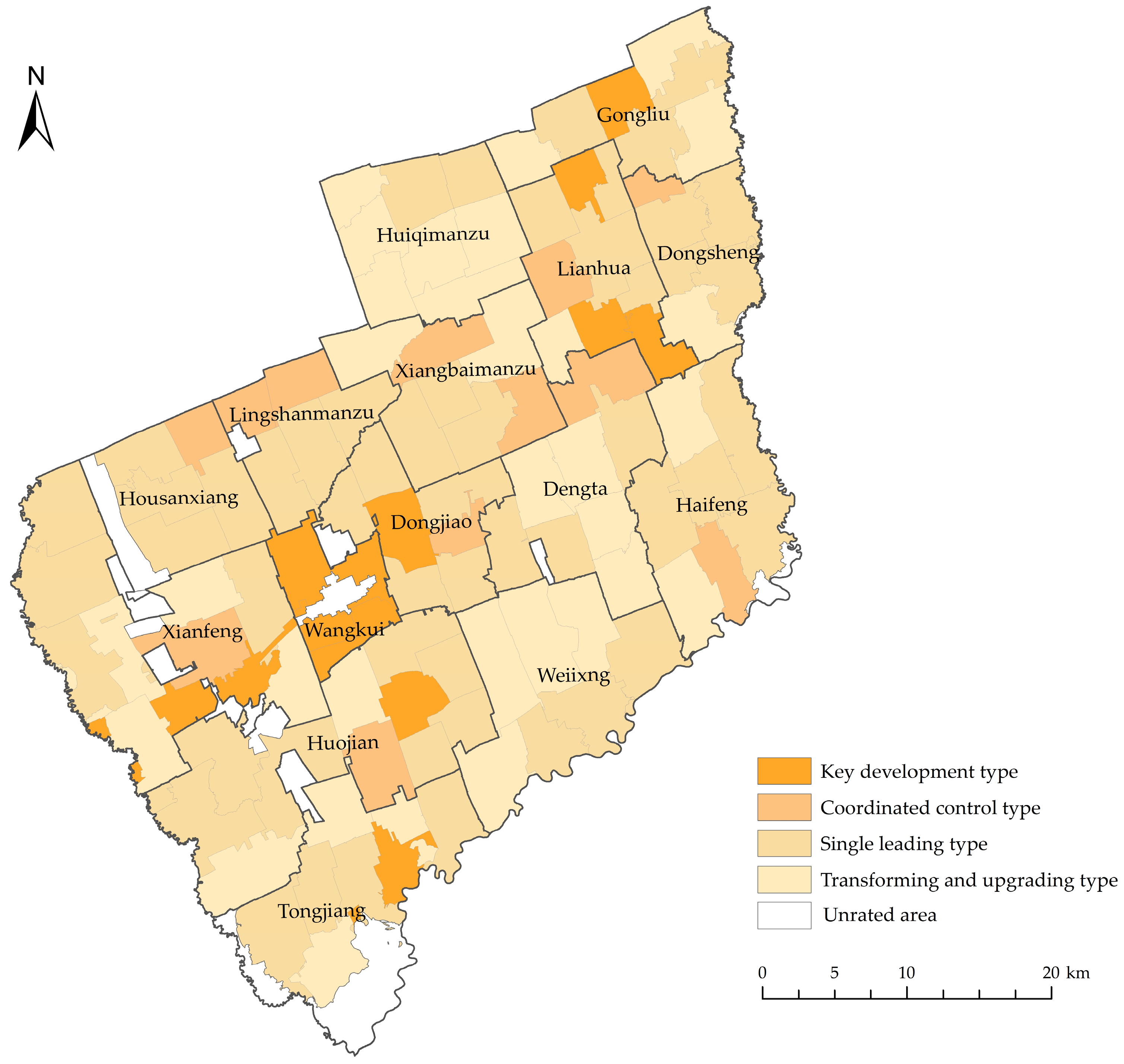
3.2. Classification and Optimization Scheme of Rural Residential Areas

This study aimed to improve the utilization quality of rural residential areas, and it followed the principles of the synchronous development of intensive land utilization, human settlement environment quality, and ecological environment quality to classify the optimization types of rural residential areas. First, the three aspects, namely, intensive land utilization, human settlement environment quality, and ecological environment quality, were encoded and combined. There were 27 possible combinations. Based on the actual situation in the study area, 23 types were finally derived. Second, according to the discrimination principles, if the three aspects developed synchronously and were all at the same level, then this was classified as the coordinated-control type. If the development levels of the three aspects were not synchronous and two or more of them were at a high level, then this was classified as the key-development type. If only one aspect was at a high level, then this was classified as the single-leading type. If all three aspects were at a low or medium level, then this was classified as the transforming-and-upgrading type. Finally, optimization schemes were proposed based on the different types of rural residential areas (Table 2 and Figure 4).
The I2-H2-E2 combination of rural residential areas belonged to the coordinated-control type. These areas were mostly distributed around villages near town or township governments. Their overall strength was relatively coordinated, and they did not have prominent advantages in intensive land utilization, human settlement environment quality, or ecological environment quality; however, they still had substantial potential for development. In the future, we must adhere to this coordinated control, focus on the effective combination of “quality” and “quantity”, rely on the conditions of economic development, and strengthen the communication and cooperation with surrounding villages. Moreover, we should establish pillar industries for the villages’ development, thoroughly dig into the added value of agricultural products, strive to build a complete industrial chain for grain production, and construct a modern agricultural production system. In addition, we should improve the service capabilities of the various facilities within the villages and try to achieve the sharing of the construction of infrastructure and public service facilities with nearby towns and townships. Finally, we must reduce the use of pesticides and fertilizers and promote the use of degradable plastic film.
The I1-H1-E3, I1-H2-E1, I1-H3-E1, and I3-H1-E1 combinations of the rural residential areas belonged to the key-development type, which was mostly distributed in villages where the town or township governments were located. The quality of their utilization was relatively good, the land scale structure was reasonable, the degree of livability was high, and the ecological environment was clean. Overall, there were single obstacles in the intensive land utilization, human settlement environment quality, and ecological environment quality. In the future, we must stick to giving full play to each region’s advantages, adhering to a high-quality-utilization orientation, and adopting effective strategies based on local conditions to improve shortcomings. We can integrate advantageous resources and industrial foundations, support the development of modern agriculture and rural tourism, seize the opportunity to create agricultural-ecological tourism projects, and achieve industrial integration. Furthermore, we should continue to improve the levels of various facilities, continuously improve the living environment, and focus on green and healthy development to achieve the high-quality utilization of rural residential areas.
The I1-H2-E2, I1-H2-E3, I1-H3-E2, I1-H3-E3, I2-H1-E2, I2-H1-E3, I3-H1-E2, I3-H1-E3, I2-H2-E1, I2-H3-E1, I3-H2-E1, and I3-H3-E1 combinations of the rural residential areas belonged to the single-leading type, which was mostly distributed in the central region. They had certain developmental advantages in one aspect of intensive land utilization, the human settlement environment quality, or ecological environment quality, and they showed obvious directional characteristics. This type of rural residential area should persist with the existing advantages as guidance and consider the improvement of weak functions. For intensive land use, it is necessary to activate the stock land and improve the land-use efficiency, and at the same time, improve the living conditions and ecological environment. For the high-quality living environment orientation, it is necessary to establish a long-term protection mechanism for human settlements and to orderly guide village construction while strengthening environmental governance. For the ecological function orientation, it is crucial to insist on the developmental concept of healthy environmental protection and to deeply explore the connotation value of ecological tourism. Meanwhile, we should strengthen the efficient and intensive use of land and improve the living environment.
The I2-H2-E3, I2-H3-E2, I2-H3-E3, I3-H2-E2, I3-H2-E3, and I3-H3-E2 combinations of rural residential areas belonged to the transforming-and-upgrading type, which was mostly distributed in the peripheral areas. Their utilization quality was relatively poor, and their intensive land utilization, human settlement environment quality, and ecological environment quality were mostly in a weak position. For this type of rural residential area, we should strengthen the transformation and upgrading, control the scale, and promote reasonable development. We must give full play to the guiding role of village planning, integrate low-efficiency and extensive rural residential areas, and strictly control the disorderly expansion of land use. Moreover, we should improve various agricultural production facilities and enhance the effective output of the cultivated land. It is equally important that we should guarantee the daily shopping, medical, and other basic needs of villagers; improve the connectivity between the rural residential areas; strengthen the village environmental governance; and add garbage and sewage treatment facilities to realize the sustainable development of the ecological environment.

3.3. Analysis of Obstacle Factors

According to Formula (7), the main obstacle factors affecting the quality of the rural residential utilization in Wangkui County were diagnosed based on their obstacle degrees. At the same time, based on the high and low obstacle-degree scores, the top five factors were sorted as the main obstacle factors. These factors were the traffic land density, aggregation index, green-coverage rate of built-up areas, completeness of public service facilities, and proportion of secondary and tertiary industrial land area (Table 3).
According to Table 2 and Figure 5, the top-ranked factor in terms of its overall obstacle degree was the traffic land density, with an obstacle degree score of 12.92%. This factor had a significant impact on villages located in high- and medium-quality areas, indicating that the accessibility of transportation in these areas was relatively low. Issues such as damaged road surfaces need to be urgently resolved. This phenomenon substantially affected the convenience of the villagers’ travel and agricultural production activities.
The second-ranked factor in terms of its overall obstacle degree was the aggregation index, with an obstacle-degree score of 11.56%. This factor negatively impacted medium- and low-quality areas, indicating that the layouts of the rural residential areas in these regions were dispersed, which made it difficult to plan and manage them uniformly. This extensive use of land resources resulted in wastage and affected the intensive use of the land.
The third-ranked factor in terms of its overall obstacle degree was the green-coverage rate of built-up areas, with an obstacle-degree score of 10.02%. The obstacle degree was higher in the high-quality areas, which indicated that the green-coverage rates in these villages were relatively low and the sanitation conditions urgently need to be improved. As the concepts of healthy and sustainable living become more widespread, people have higher demands for their living environments. Therefore, we should make efforts to accelerate the construction of gardens and green spaces to improve the quality of the ecological environment.
The fourth-ranked factor in terms of its overall obstacle degree was the completeness of public service facilities, with an obstacle-degree score of 9.52%. There was a large gap in the level of public service facilities in rural residential areas, with most villages having only small clinics and a few shops. Medium-quality villages in particular can only provide simple living guarantees for villagers and make it difficult to meet higher-level needs, such as education, medical care, and cultural and sports activities.
The fifth-ranked factor in terms of its overall obstacle degree was the proportion of secondary and tertiary industrial land area, with an obstacle-degree score of 9.05%. Overall, the villages lacked opportunities for the development of secondary and tertiary industries. Traditional agricultural production was still the main source of income for villagers. It was difficult to form a complete industrial chain due to the lack of personnel, technology, policies, and other factors.
In short, to achieve the high-quality development of rural residential areas, we should persist with strengthening the construction of road and transportation networks, rationally optimize their layout, increase their green-coverage rate, improve their level of public services, and accelerate the construction of village industries.

4. Discussion

4.1. Construction of Rural Residential Areas Utilization Quality Index System

Compared with previous studies by scholars such as Chen, Zhu, and Liu, who researched intensive-land-utilization evaluation [12,13,14]; Lu, Zhu, and Tang, who researched human-settlement-quality evaluation [15,16,17]; and Hong, Wang, and Zhang, who studied ecological-suitability evaluation [18,19,20], the quality evaluation of rural residential areas provides a new integrated research perspective for the optimization and development of rural settlements. The evaluation is not limited to the single aspects of intensive land utilization, human settlement environment quality, or ecological environment quality research. Instead, it incorporates elements of land, human habitat, and ecology into the indicator system, and it conducts a comprehensive and systematic quantification and analysis that fully reflects the requirements of the current era of the high-quality development of rural residential areas. At the same time, for the selection of the indicators, we considered the fact that the study area selected for this research was located in the Northeast Plain agricultural region of China and undertook the important task of safeguarding food production. Therefore, the ecological impact of the agricultural production was considered when constructing the ecological indicators for the rural residential areas, and indicators such as the intensity of use of fertilizers, pesticides, and agricultural plastic films were added.

4.2. Classification Analysis of Rural Residential Areas

Taxonomy is a science that is used to distinguish between different categories of things [43]. Determining a reasonable classification scheme for rural residential areas is beneficial for the specific implementation of optimization strategies. Among the existing research on the classification of rural residential areas, the use of matrices that rely on a combination of multidimensional features is a more common method. For example, Chen [41] classified rural residential areas in the Loess hilly–gully region based on the three-dimensional features of size, location, and layout, using the multidimensional combination matrix. Zhang [44] used the multidimensional combination matrix to classify rural residential areas in Pinggu District from the three dimensions of size, morphology, and location. Wang [45] used the combination matrix method to classify the rural residential areas in Feixiang County, Hebei Province, in terms of the three dimensions of size, morphology, and location. Qu [46] implemented the classification of rural residential areas based on multifactor feature coupling in terms of the three dimensions of balance between the rural production and labor structure, suitability of the human-habitat environment, and intensity of land use. The above research showed that the application of the multidimensional combination matrix in the classification of rural settlements was relatively extensive, fully reflecting the multidimensional information of rural residential areas and revealing the organic connections between the different dimensions. Based on relevant research, in this study, we used the multidimensional combination matrix to classify the rural residential areas into different types based on three aspects, namely, intensive land utilization, human settlement environment quality, and ecological environment quality, and then we proposed targeted policy suggestions that can verify the scientific validity and reliability of the research results.

4.3. Obstacle Factors Affecting the Utilization of Rural Residential Areas

In the existing research on the obstacle factors of rural residential areas, Zhang [47] pointed out that the rural road density and proportion of public space area are the main factors that affect rural residential areas. Lv [48] considered that the green-coverage rate has a significant impact on the livability of rural residential areas. Qu [49] demonstrated that the transportation conditions, infrastructure construction, and ecological environment are the main obstacle factors that affect rural residential areas. This study used the obstacle degree model to identify the obstacle factors that affect the high-quality utilization of rural residential areas, and it determined the top five obstacle factors, based on their obstacle degree, as the main obstacle factors. The specific order was as follows: transportation land density > aggregation index > built-up area green-coverage rate > completeness of public service facilities > proportion of secondary and tertiary industrial land area. The research results of previous scholars support the conclusions of this study, and these factors indeed have a certain degree of impact on the high-quality development of rural residential areas and should be improved during the optimization process.

4.4. Limitations and Future Work

It is worth noting that the study area was located in the agricultural region of the Northeast China Plain. In the process of constructing the index system, factors such as the scale, location, and farming conditions of the rural settlements were the main ones considered, while the influences of the topography and terrain were not. The indicators selected for this study were all aimed at achieving the high-quality utilization of rural residential areas in plain agricultural areas. Specific analyses should be conducted according to the local conditions in different regions, and the regional characteristics should be emphasized. Due to the limitations in the data availability, this study should be expanded and improved in the future. In the construction of the index system, there was a lack of consideration for indicators that are difficult to quantify, such as economic development, the villagers’ attitude, folk customs, and institutional policies. In addition, the evaluation of the utilization quality of rural residential areas requires comprehensive research that involves many aspects and is still in the early stages of development, with relatively few mature research results. Therefore, in future research, it will be necessary to further reflect on the implications of the utilization quality of rural residential areas in light of modern requirements, to continue to strengthen the quantification of the indicators and enhance their refinement and dynamism, and to put forward more practical and feasible suggestions for the high-quality development of rural residential areas.

5. Conclusions

This study took Wangkui County as the study area—which is located in a typical agricultural area of the Northeast Plain in Heilongjiang Province—and it constructed an evaluation index system to assess the utilization quality of rural residential areas in terms of three aspects: intensive land utilization, human settlement environment quality, and ecological environment quality. Based on the evaluation results, the multidimensional combination matrix was used to classify the rural residential areas. The obstacle diagnosis model was employed to analyze the obstacle factors that affected the high-quality utilization of rural residential areas, providing the basis for their high-quality development. The research conclusions were as follows:
(1)
This study demonstrated that the utilization quality of the rural residential areas in Wangkui County was mainly at a moderate level, followed by low-level utilization quality, and, finally, high-level utilization quality. In terms of spatial distribution, the evaluation results of the utilization quality of the rural residential areas showed a circular distribution pattern, with the overall quality of utilization decreasing from the centers of the county towns to the surrounding areas. The central region had relatively intensive land utilization and strong suitability and convenience for production and living. With the increase in the distance from the central town, the advantageous locational conditions became less obvious. Furthermore, various types of service facilities were lacking, and the pollution caused by agricultural production became more severe. This phenomenon led to the poorer utilization quality of rural residential areas.
(2)
According to the evaluation results of the utilization quality of the rural residential areas, and using the multidimensional combination matrix to code and combine them, a total of 23 combination types were obtained. Based on the above results, the rural residential areas were divided into four types: the coordinated-control type, the key-development type, the single-leading type, and the transforming-and-upgrading type. Specific optimization measures were proposed for each type according to its characteristics.
(3)
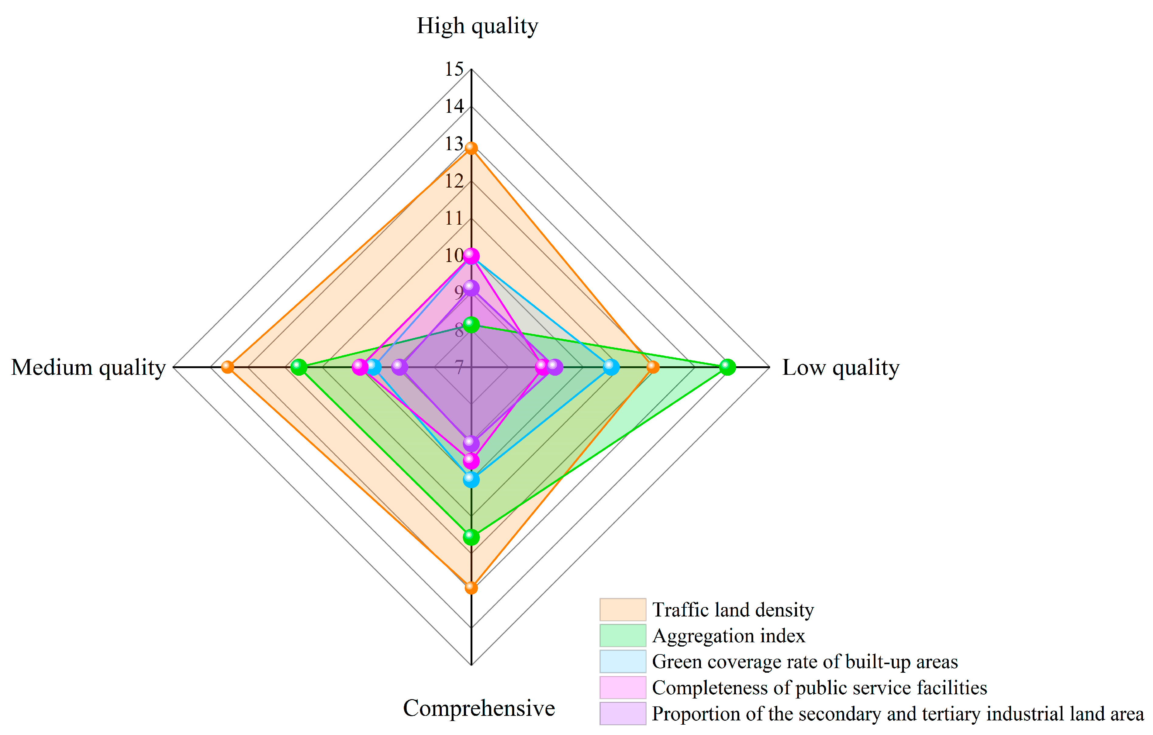
Based on the diagnosis results of the obstacle factors, we found that the top five obstacle factors affected the high-quality utilization ranking of the rural residential areas in Wangkui County; these obstacle factors were the traffic land density, aggregation index, green-coverage rate of built-up areas, completeness of public service facilities, and proportion of secondary and tertiary industrial land area. In the future, we must focus on alleviating the main obstacle factors to enhance the utilization quality of rural residential areas.

Author Contributions

Conceptualization, H.Z. and R.C.; methodology, H.Z.; validation, H.Z., R.C. and S.L.; formal analysis, S.L.; resources, H.Z. and R.C.; data curation, R.C.; writing—original draft preparation, R.C.; writing—review and editing, H.Z. and R.C.; visualization, R.C. and S.L.; supervision, H.Z.; project administration, H.Z.; funding acquisition, H.Z. All authors have read and agreed to the published version of the manuscript.

Funding

This research was funded by the Strategic Priority Research Program of the Chinese Academy of Sciences, grant number XDA28130402, the National Natural Science Foundation of China, grant number 41402297, and the Postdoctoral funded project in Heilongjiang Province, grant number LBH-Z12032.

Institutional Review Board Statement

Not applicable.

Informed Consent Statement

Informed consent was obtained from all subjects involved in the study.

Data Availability Statement

Not applicable.

Acknowledgments

We would like to express our gratitude to the professionals of the Northeast Agricultural University who encouraged us to make this project a success.

Conflicts of Interest

The authors declare no conflict of interest.

References

  1. Tu, S.S.; Zhou, X.Y.; Long, H.L.; Liang, X.L. Progress and Prospects of Research on the Evolution and Optimization of Rural Settlement Space. Econ. Geogr. 2019, 39, 142–149. [Google Scholar] [CrossRef]
  2. Feng, J.H.; Ma, G.Q.; Li, J.; Zhu, C. Rural Residential Area Consolidation Strategy Based on Population Density and Layout Suitability—Taking Huating City in Gansu Province as an Example. Soil Bull. 2022, 53, 768–776. [Google Scholar] [CrossRef]
  3. Liu, Y.S.; Yang, R.; Li, Y.H. Potential of Land Consolidation of Hollowed Villages under Different Urbanization Scenarios in China. J. Geogr. Sci. 2013, 23, 503–512. [Google Scholar] [CrossRef]
  4. Feng, Y.F.; Zhao, S.L. Evaluation and Promotion Strategies of Sustainable Development of Rural Human Settlement Environment in Shandong Province. Chin. Agric. Resour. Reg. Plan. 2021, 42, 155–162. Available online: https://kns.cnki.net/kcms2/article/abstract?v=3uoqIhG8C44YLTlOAiTRKibYlV5Vjs7iy_Rpms2pqwbFRRUtoUImHQSM881s_38h081CQNoKU518d7h-2SkuM2JNkSlFGqQa&uniplatform=NZKPT (accessed on 1 April 2023).
  5. Andrew, J.H.; Daniel, G.B. Land-Use Change in Rural America: Rates, Drivers, and Consequences. Ecol. Appl. 2005, 15, 1849–1850. [Google Scholar] [CrossRef]
  6. Zheng, M.S.; Jiang, R.Z. Evaluation and Analysis of Regional Rural Ecological Environment Development Level—A Case Study of Shandong Province. J. Jiangsu Agric. Sci. 2020, 36, 1583–1588. Available online: https://kns.cnki.net/kcms2/article/abstract?v=3uoqIhG8C44YLTlOAiTRKibYlV5Vjs7iy_Rpms2pqwbFRRUtoUImHXOcTsr45Bm9pUGbdr0K4735TZaNVmkVNd7X0E7cDdjh&uniplatform=NZKPT (accessed on 1 April 2023).
  7. Sathi, S.R.; Jana, N.C. Impact of Geomorphic Attributes on Rural Settlement Distribution:A Case Study of Baghmundi Block in Purulia District, West Bengal. Int. J. Innov. Res. Dev. 2015, 4, 121–132. [Google Scholar]
  8. Cécile, T.; Robin, C.; Samuel, L.; Elisabeth, Z. An agent-based model for exploring the combined effects of social and demographic changes on the concentration and hierarchy of rural settlement patterns in North-Western Europe during the Middle Ages (800–1200 CE). J. Anthropol. Archaeol. 2020, 59, 101204. [Google Scholar] [CrossRef]
  9. Scorza, F.; Gatto, R.V. Identifying Territorial Values for Tourism Development: The Case Study of Calabrian Greek Area. Sustainability 2023, 15, 5501. [Google Scholar] [CrossRef]
  10. Dušan, R.; Danijela, V.; Miroljub, M. Tourism and sustainable development of rural settlements in protected areas—Example NP Kopaonik (Serbia). Land Use Policy 2019, 89, 104231. [Google Scholar] [CrossRef]
  11. Dakey, S.; Morey, B.; Sukhwani, V.; Deshkar, S. Applying Socio-Ecological Perspective for Fostering Resilience in Rural Settlements—Melghat Region, India. Sustainability 2023, 15, 1812. [Google Scholar] [CrossRef]
  12. Chen, C.L.; Xu, M.J.; Zhu, P.X.; Dong, L.F. Spatial and Temporal Pattern Evolution and Intensive Use Change of Rural Residential Areas in Jiangsu Province in the Past 30 Years. Resour. Environ. Yangtze Basin 2020, 29, 2124–2135. Available online: https://kns.cnki.net/kcms2/article/abstract?v=3uoqIhG8C44YLTlOAiTRKibYlV5Vjs7i8oRR1PAr7RxjuAJk4dHXolp6nnN5bwbhs2JqcBNMDsY6BMAIsO8M2sN8TpuRdEN3&uniplatform=NZKPT (accessed on 1 April 2023).
  13. Zhu, T.F.; Zhang, F.R.; Li, C.; Wang, L. Evaluation of intensive land use in rural residential areas: A case study of Mentougou District, Beijing. Territ. Nat. Resour. Study 2015, 34, 160–165. [Google Scholar]
  14. Liu, Y.B.; He, Q.; Zhang, F.F.; Cheng, Q.; Gao, X. Study on Evaluation of Intensive Land Use of Rural Residential Areas Based on Multi-dimensional Perspective: A Case Study of Tianchang City in Anhui Province. China Land Resour. Econ. 2022, 35, 83–89. [Google Scholar] [CrossRef]
  15. Yu, L.; Xie, D.; Xu, X. Environmental Suitability Evaluation for Human Settlements of Rural Residential Areas in Hengshui, Hebei Province. Land 2022, 11, 2112. [Google Scholar] [CrossRef]
  16. Zhu, Y.Y.; Zhou, X.Q.; Luo, J.; Cui, J.X. Evaluation of rural living environment quality and its spatial-temporal differentiation in the middle reaches of the Yangtze River urban agglomeration. Econ. Geogr. 2021, 41, 127–136. [Google Scholar] [CrossRef]
  17. Tang, N.; Wang, C. Comprehensive Evaluation and Spatial Differentiation of Rural Habitat Environment in Chongqing County. Res. Soil Water Conserv. 2018, 25, 315–321. [Google Scholar] [CrossRef]
  18. Hong, B.T.; Ren, P. Evaluation of ecological suitability for rural residential land based on minimum cumulative resistance model: A case study of Dujiangyan City. Resour. Environ. Yangtze Basin 2019, 28, 1386–1396. Available online: https://kns.cnki.net/kcms2/article/abstract?v=3uoqIhG8C44YLTlOAiTRKibYlV5Vjs7iLik5jEcCI09uHa3oBxtWoNCdDOHaOjyu_QWd1df9hQERweslBHIYoIgdccUabU63&uniplatform=NZKPT (accessed on 1 April 2023).
  19. Wang, S.H.; Li, Q.; Deng, S.H. Evaluation and optimization of rural residential areas based on ecological sensitivity and land suitability analysis: A case study of Tunchang County, Hainan Province. Chin. Agric. Resour. Reg. Plan. 2017, 38, 27–35. [Google Scholar] [CrossRef]
  20. Wen, B.; Liu, Y.Z.; Xia, M. Suitability Evaluation of Rural Residential Land from Perspective of Ecological Protection—A Case Study on Yixing City of Jiangsu Province. Water Soil Bull. 2016, 36, 280–285. [Google Scholar] [CrossRef]
  21. Hu, M.L.; Yong, X.Q.; Li, X.; Zhou, X.X. Optimization of spatial layout of rural residential areas under the guidance of urban-rural integration development: A case study of Tongshan District, Xuzhou City. Geogr. Geo-Inf. Sci. 2022, 38, 104–110. [Google Scholar] [CrossRef]
  22. Huang, B.Y.; Xie, B.P.; Chen, Y.; Wang, B.T.; Tao, W.Q.; Pei, T.T. Optimization of rural residential areas layout based on location suitability and ecological sensitivity: A case study of Gaize County, Tibe. J. Agric. Resour. Environ. 2022, 39, 406–416. [Google Scholar] [CrossRef]
  23. Li, B.J.; Chen, L.; Gu, H.H. Study on the spatial distribution pattern and accessibility of rural residential areas in northern Jiangsu: A case study of Feng County, Xuzhou City. Soil Bull. 2021, 52, 306–313. [Google Scholar] [CrossRef]
  24. Xu, F.; Wang, Z.Q.; Zhang, H.W. Research on the reuse of rural residential areas with the introduction of ecological concept. Resour. Sci. 2017, 39, 1299. [Google Scholar] [CrossRef]
  25. Zhang, G.J.; Zhu, Y.M.; Zang, L.; Yang, H.; Zhang, P.T. Evaluation and zoning of spatial reconstruction of rural residential areas in Changli County under the background of new urbanization. J. Agric. Eng. 2016, 32, 237–246. [Google Scholar] [CrossRef]
  26. Li, X.; Xu, Y.M. Grading evaluation of rural residential area consolidation potential based on entropy weight method: A case study of Yixian County, Hebei Province. Jiangsu Agric. Sci. 2014, 42, 465–467. [Google Scholar] [CrossRef]
  27. Liu, L.W.; Duan, Y.H.; Li, L.L.; Xu, L.S.; Zhang, Y.; Nie, W.Y. Spatial distribution characteristics and suitability evaluation of rural residential areas in Shanxi Province. Chin. J. Agric. Resour. Reg. Plan. 2022, 43, 100–109. Available online: https://kns.cnki.net/kcms2/article/abstract?v=3uoqIhG8C44YLTlOAiTRKibYlV5Vjs7iJTKGjg9uTdeTsOI_ra5_XS7gnrJNwHvxjteHPWxQJhUi41kX09H3PdZ9TlSOsgHi&uniplatform=NZKPT (accessed on 1 April 2023).
  28. Yang, X.Z.; Wang, Q. Evaluation of rural living env2ironment quality and its impact analysis in Wannan Tourism Area. Acta Geogr. Sin. 2013, 68, 851–867. [Google Scholar]
  29. Hou, X.H.; Wang, Z.Q.; Yang, J. Evaluation and zoning of cultivated land quality and utilization in selenium-rich areas: A case study of Sanyuan District in Fujian Province. Resour. Sci. 2015, 37, 1367–1375. [Google Scholar]
  30. Zhao, X.M.; Zhou, B.J.; Huang, X.Y.; Yi, D.; Lai, X.H.; Chen, L. Evaluation of land quality for rural collective construction based on GIS and comprehensive index method. J. Agric. Eng. 2018, 34, 249–255+302. [Google Scholar] [CrossRef]
  31. Li, Q.Y.; Fang, C.L.; Wang, S.J. Evaluation of provincial land use quality in China: Based on the perspective of “Three Livelihoods” space. Reg. Res. Dev. 2016, 35, 163–169. [Google Scholar]
  32. Wu, J.X.; Lin, H.C. Evaluation of land use quality in Hefei metropolitan area. China Land Resour. Econ. 2021, 34, 69–78. [Google Scholar] [CrossRef]
  33. Qu, Y.B.; Dong, X.Z.; Ping, Z.L.; Guan, M. Evaluation and improvement strategies of the quality of rural residential area utilization from the perspective of human-land coordination. J. Agric. Eng. 2021, 37, 252–262. [Google Scholar] [CrossRef]
  34. Li, X.B.; Liu, Y.H.; Li, P.S.; Wu, P.L.; Yu, Z.G. The influence of optimization of rural residential layout in ecologically vulnerable areas on regional ecosystem service function: A case study of Xichang City, Sichuan Province. Acta Ecol. Sin. 2022, 42, 6900–6911. [Google Scholar] [CrossRef]
  35. Wang, Z.L.; Liu, F.B.; Yang, Q.Y.; E, S.X.; Du, T. Spatiotemporal pattern evolution characteristics and ant colony simulation optimization of rural residential areas in mountainous areas: A case study of Chengjiang Town, Chongqing. J. Nat. Resour. 2022, 37, 2065–2084. [Google Scholar] [CrossRef]
  36. Zhou, Y.; Huang, H.; Liu, Y.S. Spatial distribution pattern and influencing factors of Chinese villages. Acta Geogr. Sin. 2020, 75, 2206–2223. [Google Scholar] [CrossRef]
  37. Qu, Y.B.; Jiang, G.H.; Shang, R.; Gao, Y. Intensive utilization evaluation of rural residential areas based on input-output principle. J. Agric. Eng. 2014, 30, 221–231+294. [Google Scholar] [CrossRef]
  38. Kong, Y.; Zhen, F.; Zhang, S.Q.; Liu, J.; Li, Z.Z. Thoughts on high-quality utilization evaluation of land space based on multi-source data. China Land Sci. 2020, 34, 115–124. [Google Scholar] [CrossRef]
  39. Liu, J.; Guo, C.; Liu, Y.Q.; Hou, Y.X.; Wang, A.L. Rural Spatial Reconstruction of Coupling Coordination of Suitability and Intensification in Plain Agricultural Area. J. Agric. Resour. Environ. 2022, 39, 394–405. [Google Scholar] [CrossRef]
  40. Yang, H.P.; Yang, C.X.; Xin, G.X.; Li, Y.T.; Cao, R. Multi-functional Evaluation and Optimization Strategy of Rural Residential Areas in Southwest Hilly Region: Taking Rongchang District of Chongqing City as an Example. Chin. Agric. Resour. Reg. Plan. 2020, 41, 153–161. Available online: https://kns.cnki.net/kcms2/article/abstract?v=3uoqIhG8C44YLTlOAiTRKibYlV5Vjs7i8oRR1PAr7RxjuAJk4dHXov0cYQFuNnGbJOG9EiYuUb9mVfc_pbKobMDWoYvsdm5C&uniplatform=NZKPT (accessed on 1 April 2023).
  41. Chen, Z.F.; Li, Y.R.; Liu, Y.S. Distribution pattern and type of rural settlements in the loess hilly-gully region. J. Agric. Eng. 2017, 33, 266–274+316. [Google Scholar] [CrossRef]
  42. Li, C.Y.; Nan, L. Dynamic evaluation of land ecological security and diagnosis of obstacle factors in Shaanxi Province. China Land Sci. 2015, 29, 72–81. [Google Scholar] [CrossRef]
  43. Li, Y.R.; Bu, C.L.; Cao, Z.; Liu, X.H.; Liu, Y.S. Classification Method and Empirical Study of Villages Based on the Strategy of Rural Revitalization. J. Nat. Resour. 2020, 35, 243–256. [Google Scholar] [CrossRef]
  44. Zhang, R.J.; Jiang, G.H.; Wang, M.Z.; Ma, W.Q.; He, X. Classification of rural residential area layout based on multidimensional feature combination. J. Agric. Eng. 2015, 31, 286–292. [Google Scholar] [CrossRef]
  45. Wang, J.W.; Lei, G.P.; Ma, X.P.; Zheng, Z.Z.; Le, R.C. Study on Classification of Layouts of Rural Residential Areas Based on Multi-dimensional Features Combination. Jiangsu Agric. Sci. 2018, 46, 314–318. [Google Scholar] [CrossRef]
  46. Qu, Y.B.; Wei, S.W.; Liu, M.; Zhan, L.Y.; Li, Y.N. Multidimensional spatial pattern and coupling type of rural residential areas. J. Nat. Resour. 2019, 34, 2673–2686. [Google Scholar] [CrossRef]
  47. Zhang, F.P. Evaluation of Intensive Land Use of Rural Residential Areas—A Case Study of Nanhuan Town in Rushan City. West Dev. (Land Dev. Eng. Res.) 2020, 5, 6–12. [Google Scholar]
  48. Lv, H.; Meng, Z. Evaluation of Livability and Analysis of Obstacle Factors in Rural Residential Areas in Rapidly Urbanizing Areas: A Case Study of Guanlin Town, Yixing City. J. Anhui Agric. Sci. 2022, 50, 187–192. Available online: https://kns.cnki.net/kcms2/article/abstract?v=3uoqIhG8C44YLTlOAiTRKibYlV5Vjs7iJTKGjg9uTdeTsOI_ra5_XTkgJlbpchWBg1uZw6B77uDwYlQPmZZha3qUYKilx9n9&uniplatform=NZKPT (accessed on 1 April 2023).
  49. Qu, Y.B.; Jiang, G.H.; Shang, R.; Gao, Y. Classification of Types and Improvement Models of Rural Residential Areas Based on Coupling Characteristics of System Elements. Acta Sci. Nat. Univ. Pekin. 2016, 52, 1057–1067. [Google Scholar] [CrossRef]
Figure 1. Location map of the study area. Unrated area represents the urban center and forest farm.
Land 12 00870 g001
Figure 2. Classification of rural residential areas.
Land 12 00870 g002
Figure 3. Spatial distribution map of the utilization-quality grades of rural residential areas: (a) distribution map of the intensive-land-utilization grades; (b) distribution map of the human settlement environment quality grades; (c) distribution map of the ecological-environment-quality grades; (d) distribution map of the utilization-quality grades.
Land 12 00870 g003aLand 12 00870 g003b
Figure 4. Distribution map of optimized types of rural residential areas.
Land 12 00870 g004
Figure 5. Obstacle degrees of main obstacle factors in rural residential areas’ utilization quality. The coordinate axis value represents the degree of obstruction in high-quality utilization areas, medium-quality utilization areas, low-quality utilization areas and comprehensive utilization areas.
Land 12 00870 g005
Table 1. Evaluation index system of utilization quality of rural residential areas.
Goal LevelCriteria LevelIndicator LevelIndicator WeightIndicator Attribute
Utilization quality of rural residential areasIntensive land utilizationPer capita rural residential area0.2373
Aggregation index0.2979+
Landscape-shape index0.1593
Proportion of residential-land area0.1520+
Proportion of idle-land area0.1534
Human settlement environment qualityTraffic land density0.2745
Completeness of public service facilities0.2095+
Accessibility of central towns0.1186+
Land-cultivation rate0.1665+
Proportion of secondary and tertiary industrial land area0.2309+
Ecological environment qualityGreen-coverage rate of built-up areas0.2967+
Proportion of ecological land area0.2346+
Intensity of pesticide use0.1562
Intensity of fertilizer use0.1562
Intensity of agricultural plastic film use0.1563
Note: + represent positive indicators, − represent negative indicators.
Table 2. Types and optimization directions of rural residential areas.
Evaluation Result Coding CombinationOptimization TypeOptimization Direction
I2-H2-E2Coordinated-control typeInsist on multi-functional coordinated development and focus on the effective combination of “quality” and “quantity”
I1-H1-E3 I1-H2-E1
I1-H3-E1 I3-H1-E1
Key-development typeInsist on key development, give full play to advantages and improve weaknesses according to local conditions
I1-H2-E2 I1-H2-E3 I1-H3-E2 I1-H3-E3
I2-H1-E2 I2-H1-E3 I3-H1-E2 I3-H1-E3
I2-H2-E1 I2-H3-E1 I3-H2-E1 I3-H3-E1
Single-leading typeTake advantage of dominant functions while considering improving weak functions
I2-H2-E3 I2-H3-E2 I2-H3-E3
I3-H2-E2 I3-H2-E3 I3-H3-E2
Transforming-and-upgrading typeInsist on transformation and upgrading and make sure
to control reasonable development
Table 3. Main obstacle factors of rural residential area utilization quality.
Quality CategoryObstacle Ranking
12345
High qualityObstacle factorTraffic land densityGreen-coverage rate of built-up areasProportion of secondary and tertiary industrial land areaCompleteness of public service facilitiesAggregation
index
Degree of obstruction (%)12.879.979.129.988.14
Medium qualityObstacle factorTraffic land densityAggregation
index
Completeness of public service facilitiesGreen-coverage rate of built-up areasProportion of secondary and tertiary industrial land area
Degree of obstruction (%)13.5311.629.989.638.92
Low qualityObstacle factorAggregation
index
Traffic land densityGreen-coverage rate of built-up areasProportion of secondary and tertiary industrial land areaCompleteness of public service facilities
Degree of obstruction (%)13.8711.8710.759.248.93
ComprehensiveObstacle factorTraffic land densityAggregation
index
Green-coverage rate of built-up areasCompleteness of public service facilitiesProportion of secondary and tertiary industrial land area
Degree of obstruction (%)12.9211.5610.029.529.05
Disclaimer/Publisher’s Note: The statements, opinions and data contained in all publications are solely those of the individual author(s) and contributor(s) and not of MDPI and/or the editor(s). MDPI and/or the editor(s) disclaim responsibility for any injury to people or property resulting from any ideas, methods, instructions or products referred to in the content.

