
Evaluation of Surface Crack Development and Soil Damage Based on UAV Images of Coal Mining Areas


Abstract
:1. Introduction
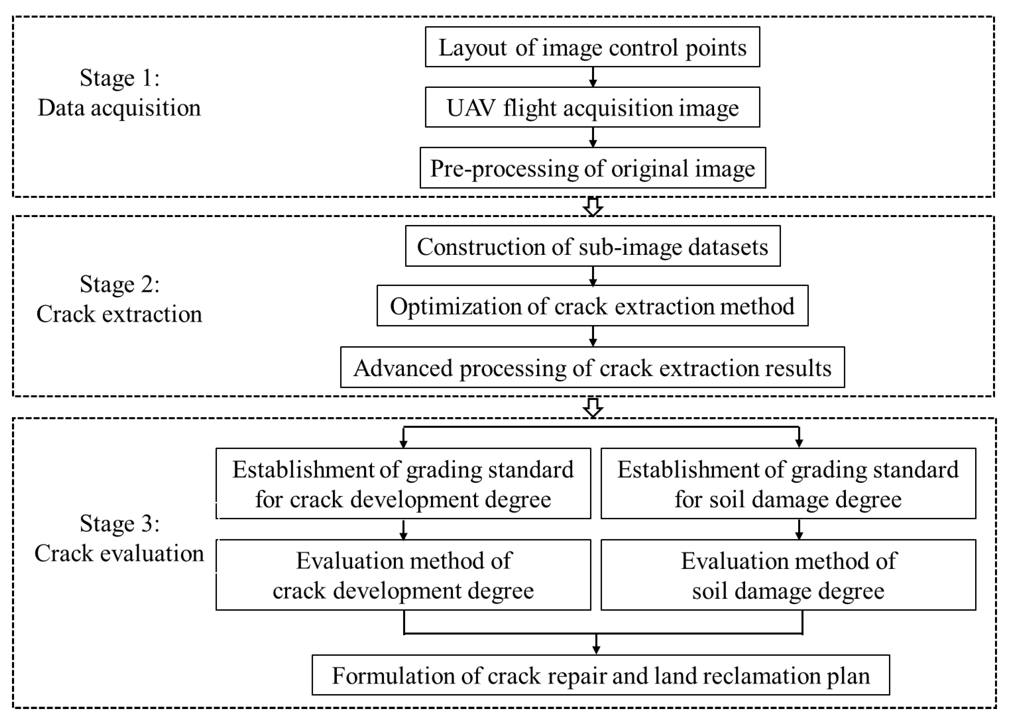
2. Materials and Methods
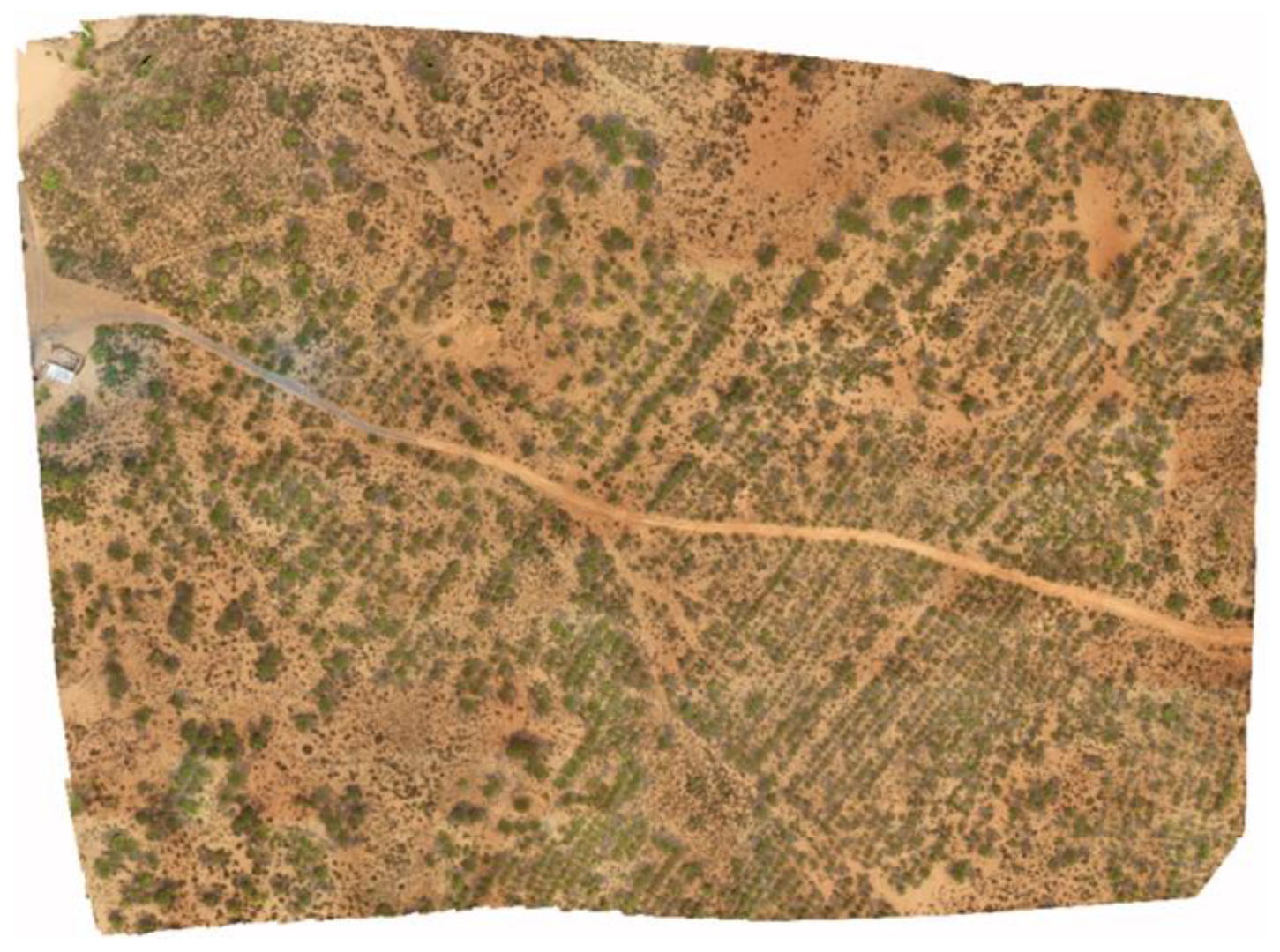
2.1. Data Source and Research Methods
2.2. Research Methods
2.3. Crack Extraction Method Based on Machine Learning
2.4. Grading Criteria Construction and Evaluation Method of Crack Development Degree
2.5. Grading Criteria Construction and Method for Evaluation of Soil Damage Degree
3. Results
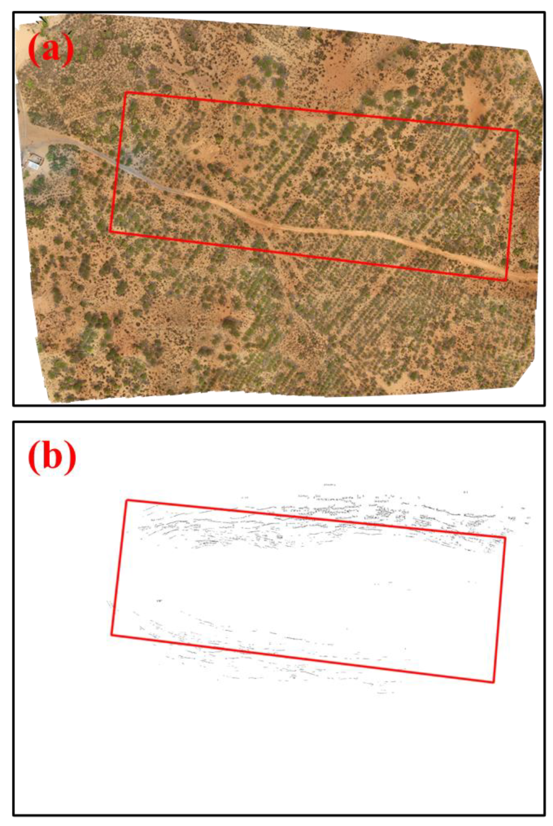
3.1. Surface Crack Extraction Results
3.2. The Results of the Construction of Grading Criteria and Evaluation for the Crack Development Degree
3.3. The Results for the Construction of Grading Criteria and Evaluation for Soil Damage Degree
4. Discussion
5. Conclusions
- (1)
- Crack density is used as an evaluation index and a grid of approximately 5 m is used as an evaluation unit for the construction of grading criteria for the crack development degree. The crack density is less than 0.4% for slight development, 0.4% to 2% for moderate development, and more than 2% for severe development.
- (2)
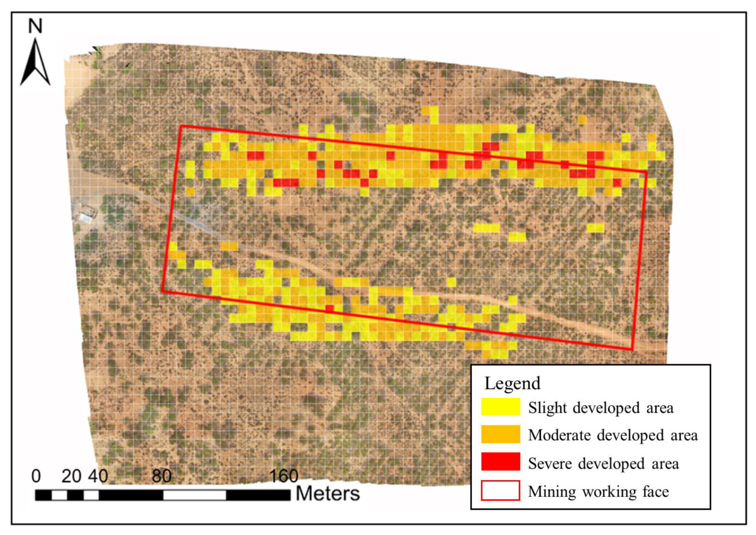
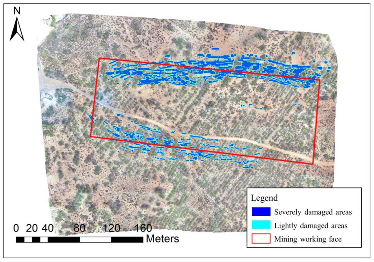
- The cracks in the study area are mainly moderate, accounting for 54.33%, and only severe in 7.40% of areas, which are mainly located in the northern fracture zone of the study area. Significantly more severe cracks were found in the northern crack zone than the southern crack zone.
- (3)
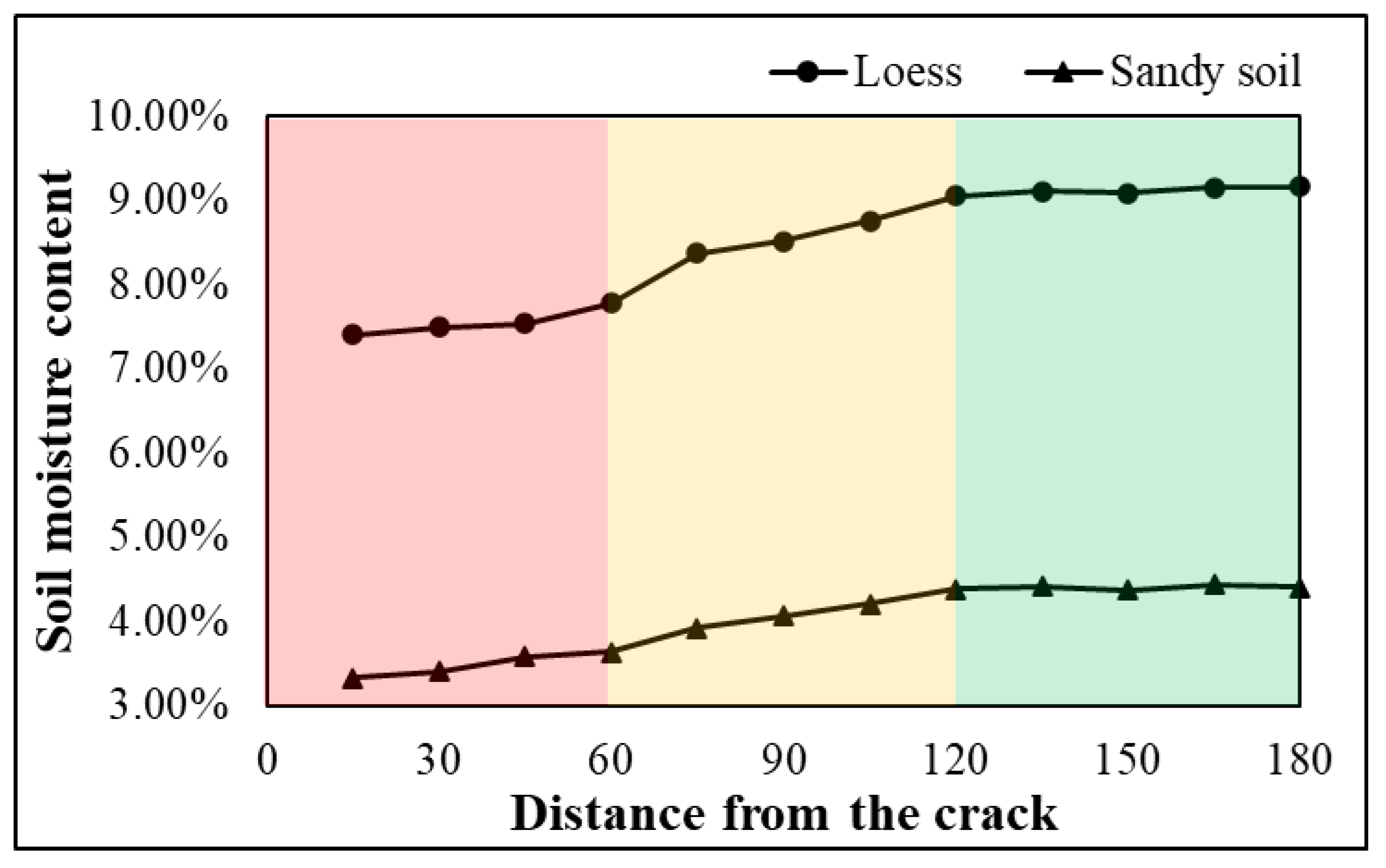
- The distance between the soil and the crack is the basis for the evaluation index for the soil damage degree. A distance within 0.6 m corresponds to an area with severe damage, between 0.6 and 1.2 m to slight damage, and more than 1.2 m to no obvious damage.
- (4)
- The percentages of the severe damage area and slight damage area in the study area were 3.36% and 4.68%, respectively. The distribution of cracks was relatively concentrated, and the cracks and damaged soil showed a striped pattern in the east-west direction.
- (5)
- By combining the evaluation results for the crack development degree and soil damage degree, the ecological restoration model of “natural restoration + crack filling + water supplementing + vegetation planting” was adopted to achieve crack restoration and land reclamation, with natural restoration for cracks in areas of slight development, crack filling for cracks in areas of moderate and severe development, water supplementation in soil areas within 1.2 m from the crack, and vegetation planting in soil areas more than 1.2 m from the crack.
Author Contributions
Funding
Data Availability Statement
Acknowledgments
Conflicts of Interest
References
- Chen, C.; Hu, Z.Q. Research advances in formation mechanism of ground fissure due to coal mining subsidence in China. J. China Coal Soc. 2018, 43, 810–823. [Google Scholar] [CrossRef]
- Xu, L.; Li, S.; Cao, X.; Somerville, I.; Suo, Y.; Liu, X.; Dai, L.; Zhao, S.; Guo, L.; Wang, P.; et al. Holocene intracontinental deformation of the northern North China Plain: Evidence of tectonic ground fissures. J. Asian Earth Sci. 2016, 119, 49–64. [Google Scholar] [CrossRef]
- Zhang, Y.X. Effects of Coal Mining on Soil Environment and Microbial Restoration in Western Area of China; China University of Mining and Technology: Beijing, China, 2016. [Google Scholar]
- Zhang, F.; Hu, Z.; Yang, K.; Fu, Y.; Feng, Z.; Bai, M. The Surface Crack Extraction Method Based on Machine Learning of Image and Quantitative Feature Information Acquisition Method. Remote Sens. 2021, 13, 1534. [Google Scholar] [CrossRef]
- Li, Y.; Yang, J.; Hu, X. Origin of ground fissures in the Shanxi Graben System, Northern China. Eng. Geol. 2000, 55, 267–275. [Google Scholar] [CrossRef]
- Wang, W.; Yang, Z.; Kong, J.; Cheng, N.; Duan, L.; Wang, Z. Ecological impacts induced by groundwater and their thresholds in the arid areas in Northwest China. Environ. Eng. Manag. J. 2013, 12, 1497–1507. [Google Scholar] [CrossRef]
- Youssef, A.M.; Sabtan, A.A.; Maerz, N.H.; Zabramawi, Y.A. Earth Fissures in Wadi Najran, Kingdom of Saudi Arabia. Nat. Hazards 2013, 71, 2013–2027. [Google Scholar] [CrossRef]
- Stumpf, A.; Malet, J.-P.; Kerle, N.; Niethammer, U.; Rothmund, S. Image-based mapping of surface fissures for the investigation of landslide dynamics. Geomorphology 2013, 186, 12–27. [Google Scholar] [CrossRef] [Green Version]
- Zhang, F.; Hu, Z.; Liang, Y.; Fu, Y.; Yang, K. An optimal approach for crack extraction from UAV sub-images after cutting. Int. J. Remote Sens. 2022, 43, 2638–2659. [Google Scholar] [CrossRef]
- Glenn, N.F.; Streutker, D.R.; Chadwick, D.J.; Thackray, G.D.; Dorsch, S.J. Analysis of LiDAR-derived topographic information for characterizing and differentiating landslide morphology and activity. Geomorphology 2006, 73, 131–148. [Google Scholar] [CrossRef]
- Kasai, M.; Ikeda, M.; Asahina, T.; Fujisawa, K. LiDAR-derived DEM evaluation of deep-seated landslides in a steep and rocky region of Japan. Geomorphology 2009, 113, 57–69. [Google Scholar] [CrossRef]
- Shruthi, R.B.; Kerle, N.; Jetten, V. Object-based gully feature extraction using high spatial resolution imagery. Geomorphology 2011, 134, 260–268. [Google Scholar] [CrossRef]
- Zhang, F.; Hu, Z.; Fu, Y.; Yang, K.; Wu, Q.; Feng, Z. A New Identification Method for Surface Cracks from UAV Images Based on Machine Learning in Coal Mining Areas. Remote Sens. 2020, 12, 1571. [Google Scholar] [CrossRef]
- Peng, J.; Qiao, J.; Leng, Y.; Wang, F.; Xue, S. Distribution and mechanism of the ground fissures in Wei River Basin, the origin of the Silk Road. Environ. Earth Sci. 2016, 75, 718. [Google Scholar] [CrossRef]
- Zheng, X.; Xiao, C. Typical applications of airborne lidar technolagy in geological investigation. ISPRS Int. Arch. Photogramm. Remote Sens. Spat. Inf. Sci. 2018, 42, 2459–2463. [Google Scholar] [CrossRef] [Green Version]
- Mohan, A.; Poobal, S. Crack detection using image processing: A critical review and analysis. Alex. Eng. J. 2018, 57, 787–798. [Google Scholar] [CrossRef]
- Nex, F.; Remondino, F. UAV for 3D mapping applications: A review. Appl. Geomat. 2014, 6, 1–15. [Google Scholar] [CrossRef]
- Quackenbush, L.J. A Review of Techniques for Extracting Linear Features from Imagery. Photogramm. Eng. Remote Sens. 2004, 70, 1383–1392. [Google Scholar] [CrossRef] [Green Version]
- Papari, G.; Petkov, N. Edge and line oriented contour detection: State of the art. Image Vis. Comput. 2011, 29, 79–103. [Google Scholar] [CrossRef]
- Maragos, P.; Sofou, A.; Stamou, G.B.; Tzouvaras, V.; Papatheodorou, E.; Stamou, G.P. Image Analysis of Soil Micromorphology: Feature Extraction, Segmentation, and Quality Inference. EURASIP J. Adv. Signal Process. 2004, 2004, 356937. [Google Scholar] [CrossRef] [Green Version]
- Pádua, L.; Vanko, J.; Hruška, J.; Adão, T.; Sousa, J.J.; Peres, E.; Morais, R. UAS, sensors, and data processing in agroforestry: A review towards practical applications. Int. J. Remote Sens. 2017, 38, 2349–2391. [Google Scholar] [CrossRef]
- Yang, S. Preliminary Study on Identification and Characterization of Rock Fracture Based on Digital Photogrammetry; China University of Mining and Technology: Xuzhou, China, 2017. [Google Scholar]
- Yin, X.T.; Dang, F.N.; Ding, W.H.; Chen, H.Q. Morphologic measurement of crack in CT images of rock and soil. Chin. J. Rock Mech. Eng. 2006, 25, 539–544. [Google Scholar]
- Liang, Y.; Zhang, F.; Yang, K.; Hu, Z. A Surface Crack Damage Evaluation Method Based on Kernel Density Estimation for UAV Images. Sustainability 2022, 14, 16238. [Google Scholar] [CrossRef]
- Fu, Y.; Shang, J.; Hu, Z.; Li, P.; Yang, K.; Chen, C.; Guo, J.; Yuan, D. Ground Fracture Development and Surface Fracture Evolution in N00 Method Shallowly Buried Thick Coal Seam Mining in an Arid Windy and Sandy Area: A Case Study of the Ningtiaota Mine (China). Energies 2021, 14, 7712. [Google Scholar] [CrossRef]
- Hoang, N.-D.; Nguyen, Q.-L. A novel method for asphalt pavement crack classification based on image processing and machine learning. Eng. Comput. 2018, 35, 487–498. [Google Scholar] [CrossRef]
- Chen, C.; Seo, H.; Jun, C.H.; Zhao, Y. Pavement crack detection and classification based on fusion feature of LBP and PCA with SVM. Int. J. Pavement Eng. 2021, 23, 3274–3283. [Google Scholar] [CrossRef]
- Li, G.; Liu, Q.; Zhao, S.; Qiao, W.; Ren, X. Automatic crack recognition for concrete bridges using a fully convolutional neural network and naive Bayes data fusion based on a visual detection system. Meas. Sci. Technol. 2020, 31, 075403. [Google Scholar] [CrossRef]
- Zhao, Y.; Sun, B.; Liu, S.; Zhang, C.; He, X.; Xu, D.; Tang, W. Identification of mining induced ground fissures using UAV and infrared thermal imager: Temperature variation and fissure evolution. ISPRS J. Photogramm. Remote Sens. 2021, 180, 45–64. [Google Scholar] [CrossRef]
- Gruszczyński, W.; Puniach, E.; Ćwiąkała, P.; Matwij, W. Correction of Low Vegetation Impact on UAV-Derived Point Cloud Heights With U-Net Networks. IEEE Trans. Geosci. Remote Sens. 2022, 60, 18. [Google Scholar] [CrossRef]
- Ćwiąkała, P.; Gruszczyński, W.; Stoch, T.; Puniach, E.; Mrocheń, D.; Matwij, W.; Wójcik, A. UAV Applications for Determination of Land Deformations Caused by Underground Mining. Remote Sens. 2020, 12, 1733. [Google Scholar] [CrossRef]
- Puniach, E.; Gruszczyński, W.; Ćwiąkała, P.; Matwij, W. Application of UAV-based orthomosaics for determination of hori-zontal displacement caused by underground mining. ISPRS J. Photogramm. Remote Sens. 2021, 174, 282–303. [Google Scholar] [CrossRef]
- Zhang, F.; Zhao, H.; Song, Y.; Chen, L. The effect of coalmining subsidence on water environment in the Shenfu-Dongsheng Mining area. Acta Geosci. Sin. 2007, 6, 521–527. [Google Scholar]
- Ma, Y.; Huang, Y.; Wang, H.; Dang, X.; Wang, J.; Gao, Y. Effect of collapse fissures caused by coal mining on soil moisture in slope lands after rain. Acta Pedol. Sin. 2014, 51, 497–504. [Google Scholar]
- Zhang, H.-B. Effects of the surface cracks caused by coal mining on soil characteristics and wheat growth in Huang-Huai-Hai Plain, China. Appl. Ecol. Environ. Res. 2017, 15, 1777–1790. [Google Scholar] [CrossRef]
- Xu, D.; Zhao, Y.; Jiang, Y.; Zhang, C.; Sun, B.; He, X. Using Improved Edge Detection Method to Detect Mining-Induced Ground Fissures Identified by Unmanned Aerial Vehicle Remote Sensing. Remote Sens. 2021, 13, 3652. [Google Scholar] [CrossRef]
- Xu, C.; Ma, S.; Zhang, H.; Wang, R.; Guan, Z. Effect of cracks on soil characteristics crop growth in subsided coal mining areas. Chin. J. Eco-Agric. 2015, 23, 597–604. [Google Scholar] [CrossRef]
- Bi, Y.; Zhang, J.; Song, Z.; Wang, Z.; Qiu, L.; Hu, J.; Gong, Y. Arbuscular mycorrhizal fungi alleviate root damage stress induced by simulated coal mining subsidence ground fissures. Sci. Total. Environ. 2018, 652, 398–405. [Google Scholar] [CrossRef]
- Mi, J.; Yang, Y.; Hou, H.; Zhang, S.; Ding, Z.; Hua, Y. Impacts of Ground Fissures on Soil Properties in an Underground Mining Area on the Loess Plateau, China. Land 2022, 11, 162. [Google Scholar] [CrossRef]
- Xiao, L.; Bi, Y.; Du, S.; Wang, Y.; Guo, C. Effects of re-vegetation type and arbuscular mycorrhizal fungal inoculation on soil enzyme activities and microbial biomass in coal mining subsidence areas of Northern China. Catena 2019, 177, 202–209. [Google Scholar] [CrossRef]


| Parameters | Value |
|---|---|
| Data type | Visible light image |
| Flight date | 1 July 2021 |
| Flight height | 50 m |
| UAV model | M210RTK |
| Camera model | DJI M100_X3 |
| Focal length | 3.6 mm |
| Ground spatial resolution (GSD) | 1.3 cm |
| Number | a1, b1 | a2, b2 | a3, b3 | a4, b4 | a5, b5 | a6, b6 | a7, b7 | a8, b8 |
|---|---|---|---|---|---|---|---|---|
| Crack size/cm | 0 × 0 | 0.5 × 3.2 | 0.5 × 6.4 | 0.5 × 9.6 | 0.5 × 12.8 | 0.5 × 16 | 1.0 × 20 | 2.0 × 20 |
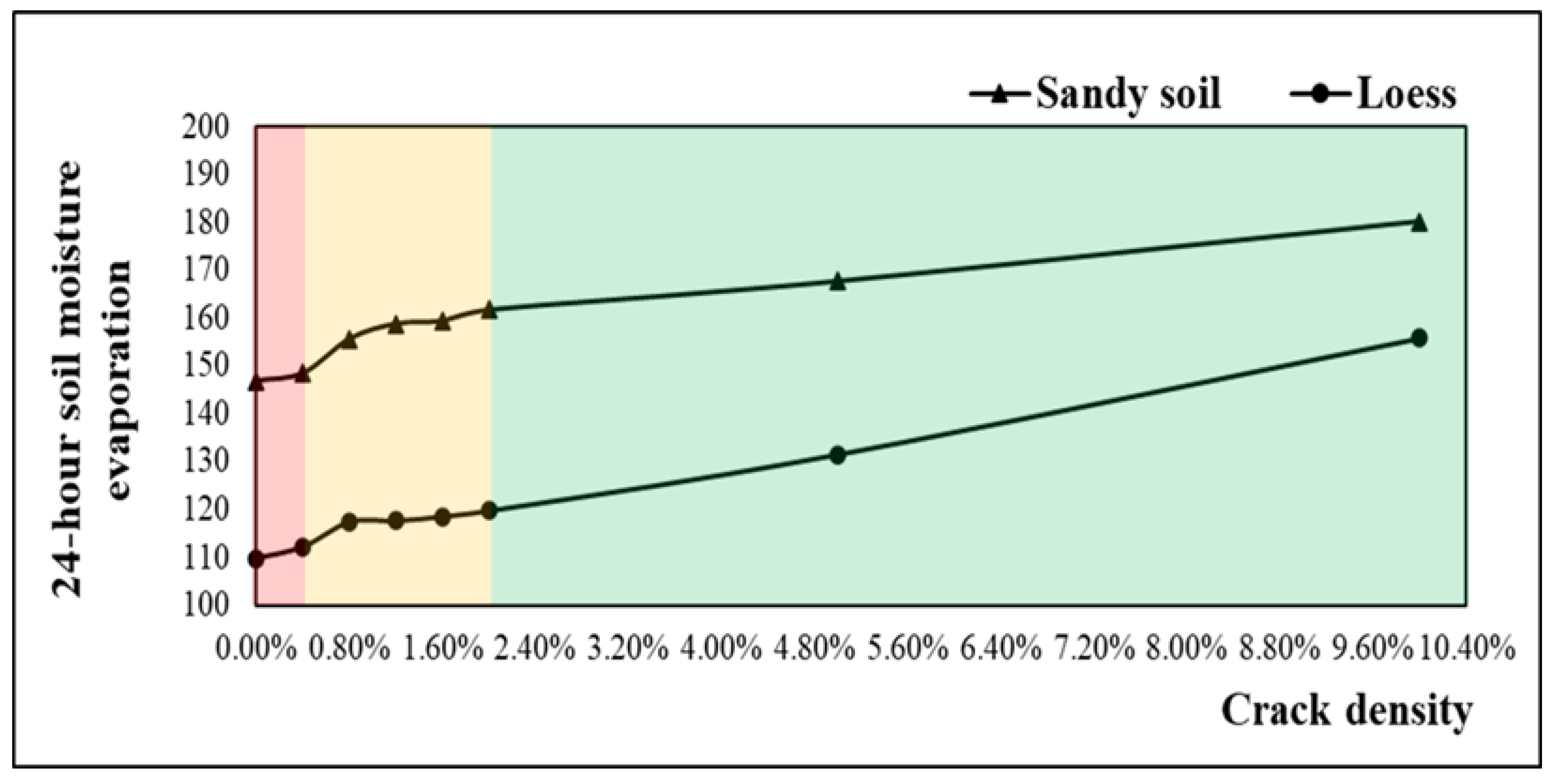
| Crack density | 0 | 0.40% | 0.80% | 1.20% | 1.60% | 2.00% | 5.00% | 10.00% |
| Number | Crack Density | Crack Size | Initial Weight/g | Weight after 24 h-Evaporation | 24 h Moisture Evaporation |
|---|---|---|---|---|---|
| b1 | 0 | \ | 4483.1 | 4373.2 | 109.9 |
| b2 | 0.40% | 0.5 × 3.2 | 4497.5 | 4385.2 | 112.3 |
| b3 | 0.80% | 0.5 × 6.4 | 4468.4 | 4350.9 | 117.5 |
| b4 | 1.20% | 0.5 × 9.6 | 4479.2 | 4361.5 | 117.7 |
| b5 | 1.60% | 0.5 × 12.8 | 4490.5 | 4371.9 | 118.6 |
| b6 | 2.00% | 0.5 × 16 | 4492.9 | 4373.1 | 119.8 |
| b7 | 5.00% | 1.0 × 20 | 4492.9 | 4361.3 | 131.6 |
| b8 | 10.00% | 2.0 × 20 | 4481.7 | 4325.8 | 155.9 |
| Number | Crack Density | Crack Size | Initial Weight/g | Weight after 24 h-Evaporation | 24 h Moisture Evaporation |
|---|---|---|---|---|---|
| a1 | 0 | \ | 4755.5 | 4608.5 | 147.0 |
| a2 | 0.40% | 0.5 × 3.2 | 4731.2 | 4582.6 | 148.6 |
| a3 | 0.80% | 0.5 × 6.4 | 4789 | 4633.2 | 155.8 |
| a4 | 1.20% | 0.5 × 9.6 | 4810.3 | 4651.4 | 158.9 |
| a5 | 1.60% | 0.5 × 12.8 | 4820.4 | 4660.9 | 159.5 |
| a6 | 2.00% | 0.5 × 16 | 4797.3 | 4635.5 | 161.8 |
| a7 | 5.00% | 1.0 × 20 | 4839.3 | 4671.5 | 167.8 |
| a8 | 10.00% | 2.0 × 20 | 4866.8 | 4686.5 | 180.3 |
| Crack Development Degree | Slight Development | Moderate Development | Severe Development |
|---|---|---|---|
| Grading criteria (crack density) | <0.4% | 0.4–2.0% | >2.0% |
| Crack Development Degree | Slight Development | Moderate Development | Severe Development |
|---|---|---|---|
| Crack density range | (2.01%, 4.37%) | (0.40%, 1.98%) | (0.01%, 0.39%) |
| Number of grids | 181 | 257 | 35 |
| Percentage | 38.27% | 54.33% | 7.40% |
| Soil Damage Degree | No Obvious Damage | Slight Damage | Severe Damage |
|---|---|---|---|
| Grading criteria (distance from the crack) | <1.2 m | 0.6–1.2 m | <0.6 m |
| Soil Damage Degree | No Obvious Damage | Slight Damage | Severe Damage |
|---|---|---|---|
| Area (m2) | 87080.55 | 3180.10 | 4436.12 |
| Percentage | 91.96% | 3.36% | 4.68% |
Disclaimer/Publisher’s Note: The statements, opinions and data contained in all publications are solely those of the individual author(s) and contributor(s) and not of MDPI and/or the editor(s). MDPI and/or the editor(s) disclaim responsibility for any injury to people or property resulting from any ideas, methods, instructions or products referred to in the content. |
© 2023 by the authors. Licensee MDPI, Basel, Switzerland. This article is an open access article distributed under the terms and conditions of the Creative Commons Attribution (CC BY) license (https://creativecommons.org/licenses/by/4.0/).
Share and Cite
Zhang, F.; Hu, Z.; Liang, Y.; Li, Q. Evaluation of Surface Crack Development and Soil Damage Based on UAV Images of Coal Mining Areas. Land 2023, 12, 774. https://doi.org/10.3390/land12040774
Zhang F, Hu Z, Liang Y, Li Q. Evaluation of Surface Crack Development and Soil Damage Based on UAV Images of Coal Mining Areas. Land. 2023; 12(4):774. https://doi.org/10.3390/land12040774
Chicago/Turabian StyleZhang, Fan, Zhenqi Hu, Yusheng Liang, and Quanzhi Li. 2023. "Evaluation of Surface Crack Development and Soil Damage Based on UAV Images of Coal Mining Areas" Land 12, no. 4: 774. https://doi.org/10.3390/land12040774