Article

Exploring the Dynamics of Occupation between Resilience and Abandonment in Two Post-Classic Rural Landscapes on the Iberian Peninsula

by
Julia Sarabia-Bautista
University Institute for Research in Archeology and Historical Heritage (INAPH), University of Alicante, 03690 Alicante, Spain
Land 2023, 12(4), 768; https://doi.org/10.3390/land12040768
Submission received: 13 February 2023 / Revised: 23 March 2023 / Accepted: 25 March 2023 / Published: 28 March 2023
(This article belongs to the Special Issue Resilience in Historical Landscapes)

Abstract

:
In this paper, we present a comparison of two rural landscapes in the southeast of the Iberian Peninsula, where the dynamics of occupation have differed since the end of the ancient world in terms of both the degree of resilience of settlements and the land use. Our purpose was to explore the social, political, economic, and environmental factors that could explain why there has been a long-term cross-cultural occupation of some resilient sites and landscapes for almost a millennium, while there have been only very specific temporary occupations in other areas. The first part of this paper describes the archaeological investigations carried out by means of intensive survey methods, geophysics, and some excavations in peripheral and peri-urban spaces. In the second part, we reflect on whether the use of the same methodology in all cases allows us to compare and understand what makes societies sustainable (or not) over time through their archaeological record.

1. Introduction

The research we have been carrying out over recent years has focused mainly on understanding and measuring interactions between societies and their environments across multiple timescales (especially from the Roman period to the Middle Ages) and spatial scales (from a regional framework, centred on the southeast of the Iberian Peninsula) [1,2]. The general objective is to reconstruct the historical socioecological systems in different landscapes using archaeological materiality, paying special attention to scenarios in which we have detected patterns of sustainability and historical resilience. In this article, we focus on presenting two case studies from the “Campos de Hellín” and the Balazote River Valley, which are located in the current province of Albacete (Spain). The enclaves of “El Tolmo de Minateda” (TM) and the “Camino Viejo de las Sepulturas” (CVS) stand out as the central places of these two regions, where the agrarian vocation remains the main economic base to this day (Figure 1). This has led to scarce urbanisation in their ecosystems. It is in these rural landscapes that we proposed to understand the causes of the permanence, transformation, or abandonment of the central places, rural settlements, and productive spaces in both areas from Late Antiquity to the Islamic period (5th to 10th centuries AD), when both territories were incorporated into the Cora or the province of Tudmīr from 713 [2].
In addition to their historical importance within the framework of our research, these landscapes were specifically selected due to the shape of the settlements and the morphology of their productive spaces, especially their agricultural systems, which are among the most homogeneous expressions of the interactions between humans and territory [3]. The application of the same methodology allowed us to contrast the data from both areas and identify any peculiarities and differences in terms of environmental patterns, social patterns, land-use management, etc., with the aim of revealing the causes of the greater or lesser resilience of the settlements and agricultural spaces analysed.

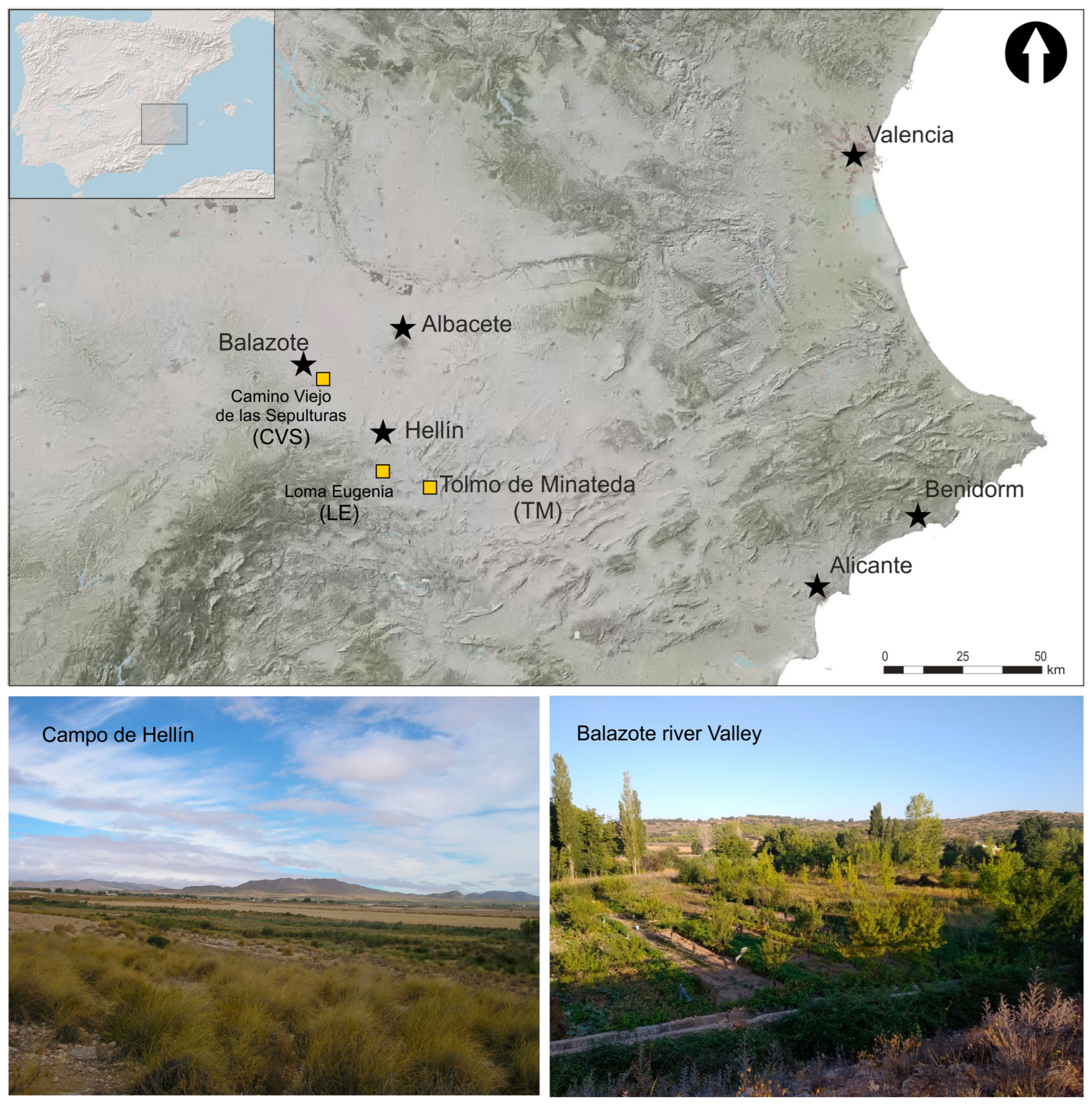
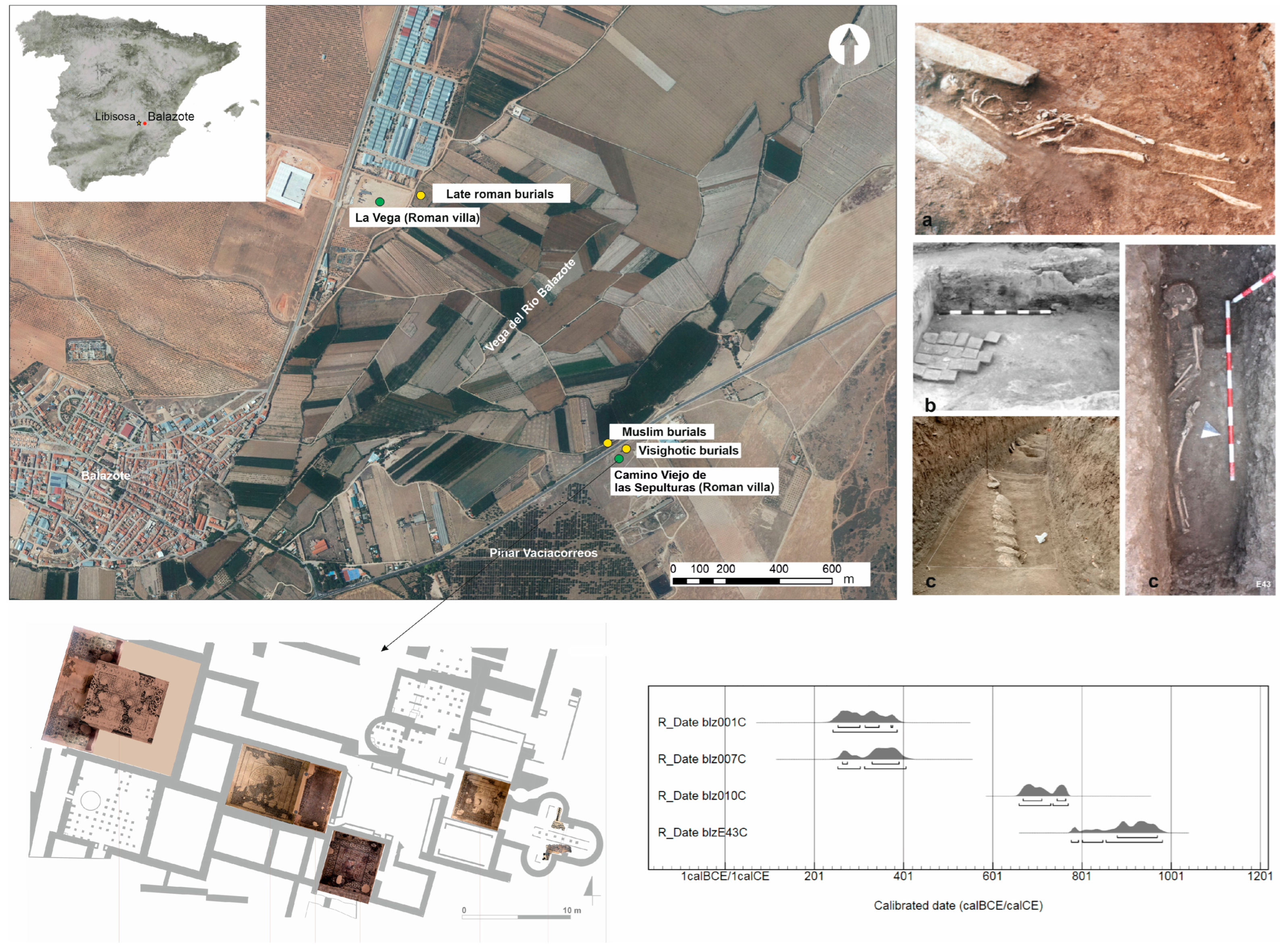
2. Methods and Context of Research

In both areas, we applied the same methodology of analysis after fusing all of the data, which allowed us to conduct a comparative study of the degree of continuity, transformation, or abandonment of rural structures since the end of the ancient world to the medieval Islamic period (5th to 10th centuries AD). The research was designed using a multiscale approach and incorporated multiple methodologies (Figure 2):
(1)
Surface surveys with offsite strategy (Figure 2a),
(2)
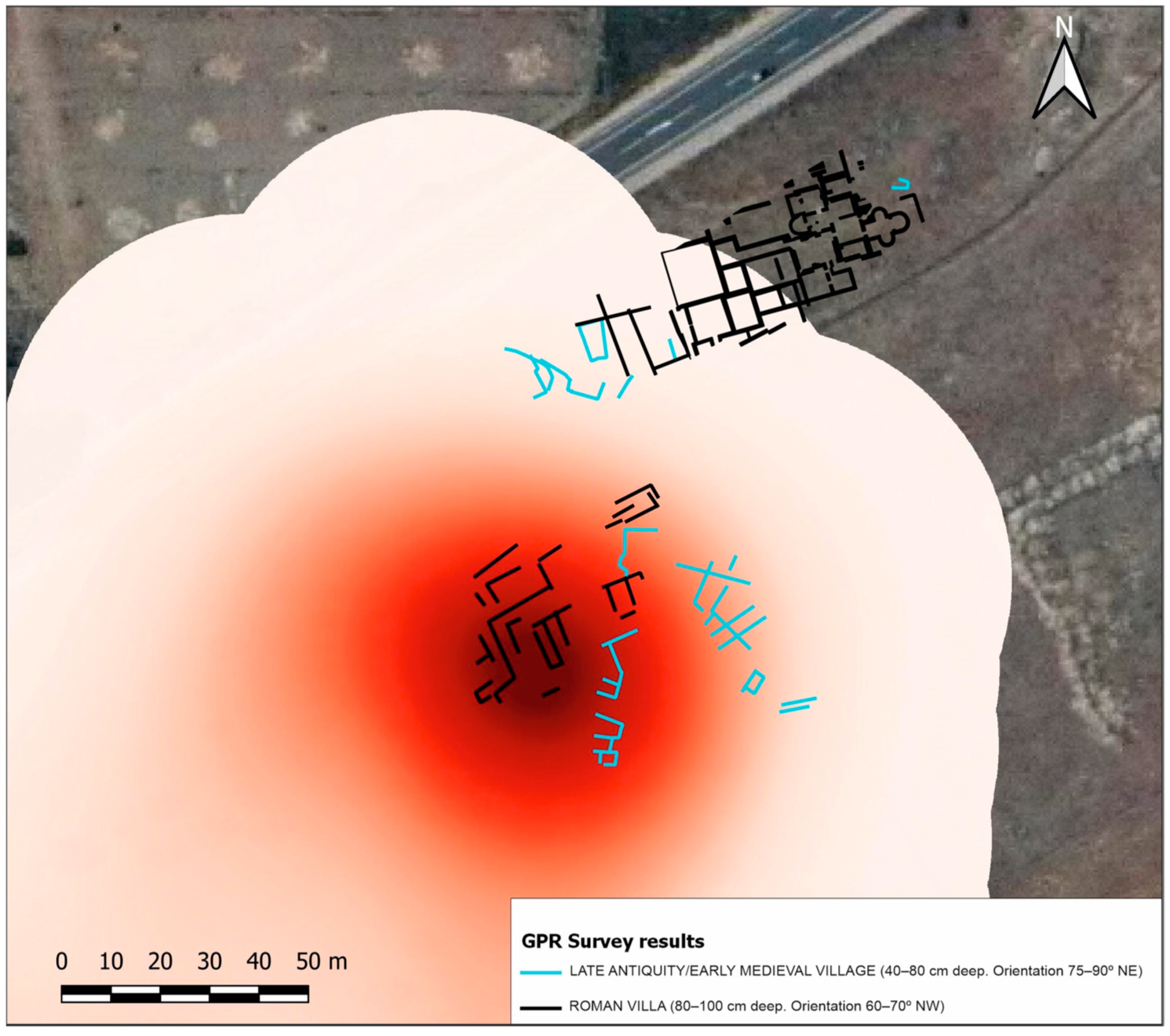
Ground-penetrating radar surveys (GPR) (Figure 2b),
(3)
Analysis of surface material repertoires, filtering the surface diagnostic materials by periods and calculating their densities,
(4)
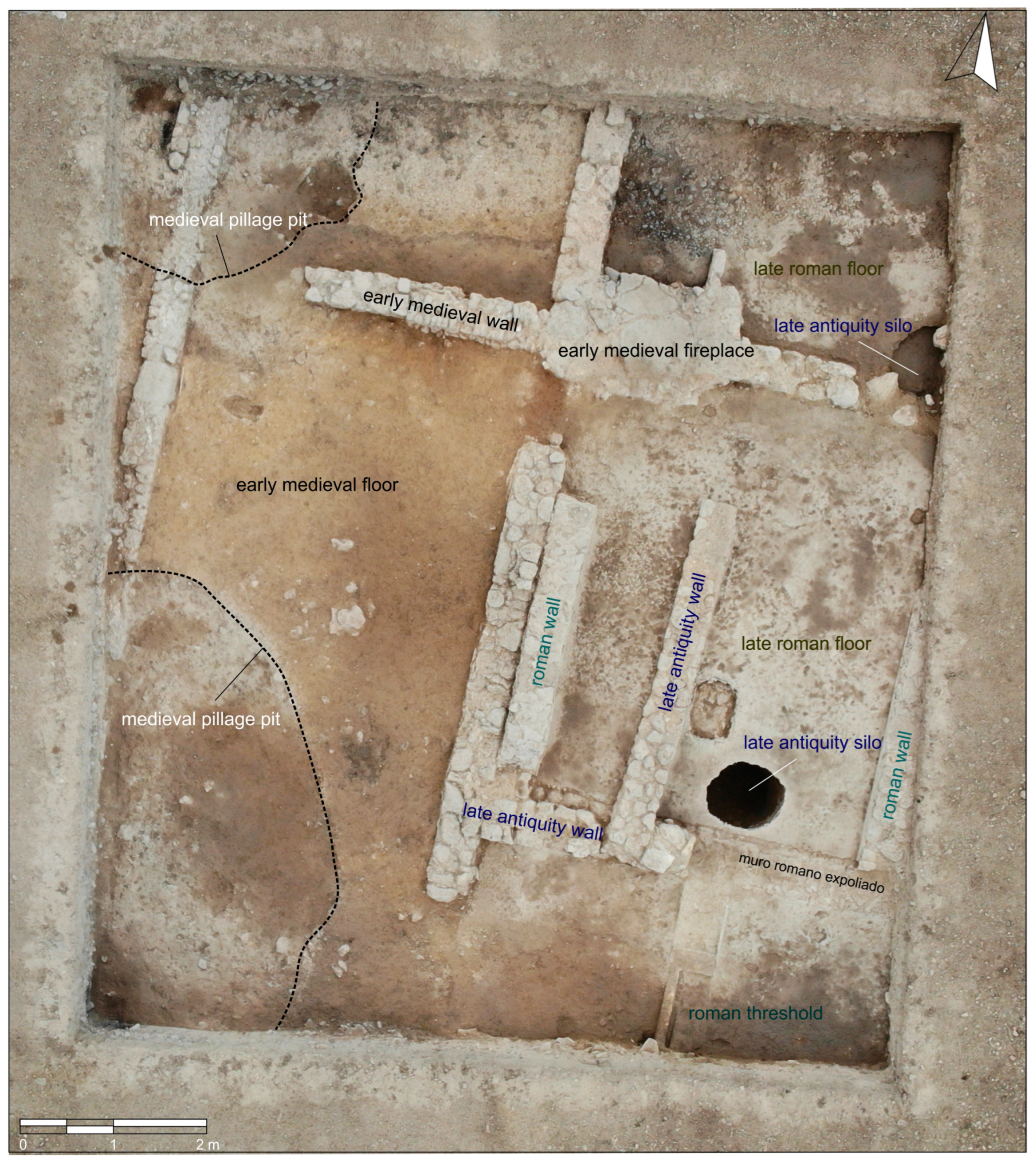
Archaeological excavations to confirm chronological sequences in some key settlements (Figure 2c),
(5)
Synthetic integration of large amounts of data into GIS platforms (Figure 2d).
During the first phases of the research, we carried out a general action to identify archaeological evidence in the different rural environments of TM and CVS, where we did not find many urban alterations. The selected transects were subjected to remote sensing and intensive full-coverage surface surveys, assisted by geospatial technologies. The data collected were integrated into a GIS environment with various cartographic sources and known archaeological sites from previous works [4,5,6,7].
This first phase allowed us to obtain a detailed archaeological cartography with a general panorama at macro-spatial scale of the settlement patterns in Roman, Visigothic, and Islamic times, the preferred areas of human occupation, and the different traces left by those societies on the landscapes. The next objective was to transcend the point locations on the map and develop a detailed characterisation of the archaeological sites. This was a question of broadening our knowledge of the places that offered the most complex surface structures of remains and the settlements that showed possible evidence of a longer occupation or, conversely, a very short occupation. For this purpose, several geophysical GPR surveys and some excavations (still in progress) were carried out at the archaeological sites of Loma Eugenia (LE, Campos de Hellín) and CVS. The village in LE has never been excavated, whereas, in CVS, excavations were carried out in the 1970s but did not document the postclassical phases with the same intensity [8]. The aim of our research was to verify the possible existence of archaeological structures, gather direct information about buried deposits, and ultimately, characterise in detail the sites identified by the dispersion of materials on the surface.
Beyond the analysis of habitat zones, our interest also focused on the recognition of the complex human interactions with landscapes, especially land uses and agricultural structures, which are the fundamental basis of rural life. To this end, we carried out surface surveys of the main rural settlements in both areas using an off-site strategy [9,10,11]. Thanks to the registration of off-site materials, we were able to evaluate the intensity with which the plots were used in the different periods, demonstrating the clear differences in management, exploitation strategies, and land uses in both regions, which were certainly also reflections of the existence of different socioeconomic and probably political models of articulation.

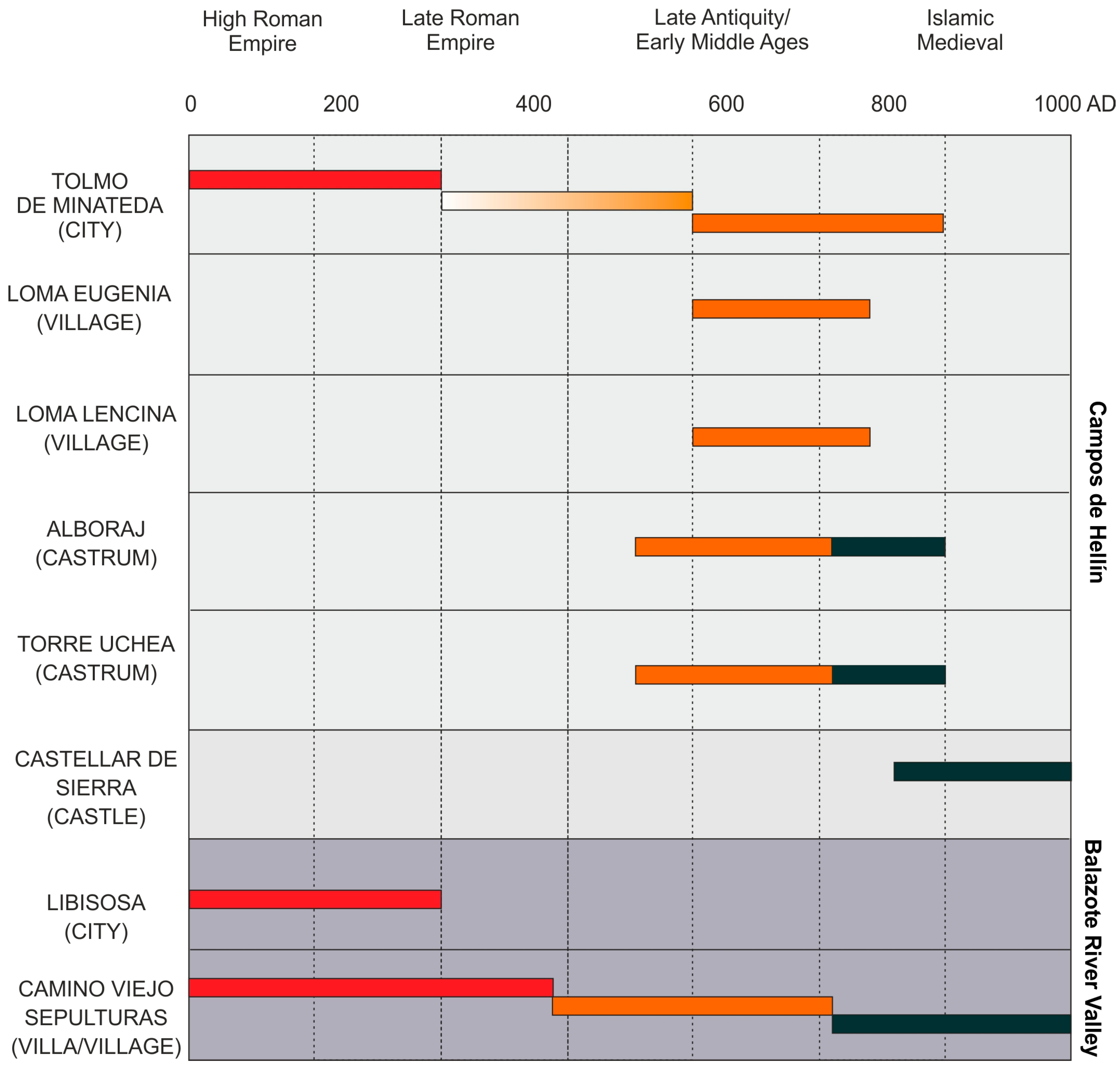
3. Results: Settlements and Land Uses

In this section, we describe our results and the evidence collected from each of the investigated landscapes. We paid special attention to the concentrations of materials, which we interpreted as settlements of several different types. We also examined the fainter dispersions that were observed, which we interpreted as evidence related to the different uses of the land.

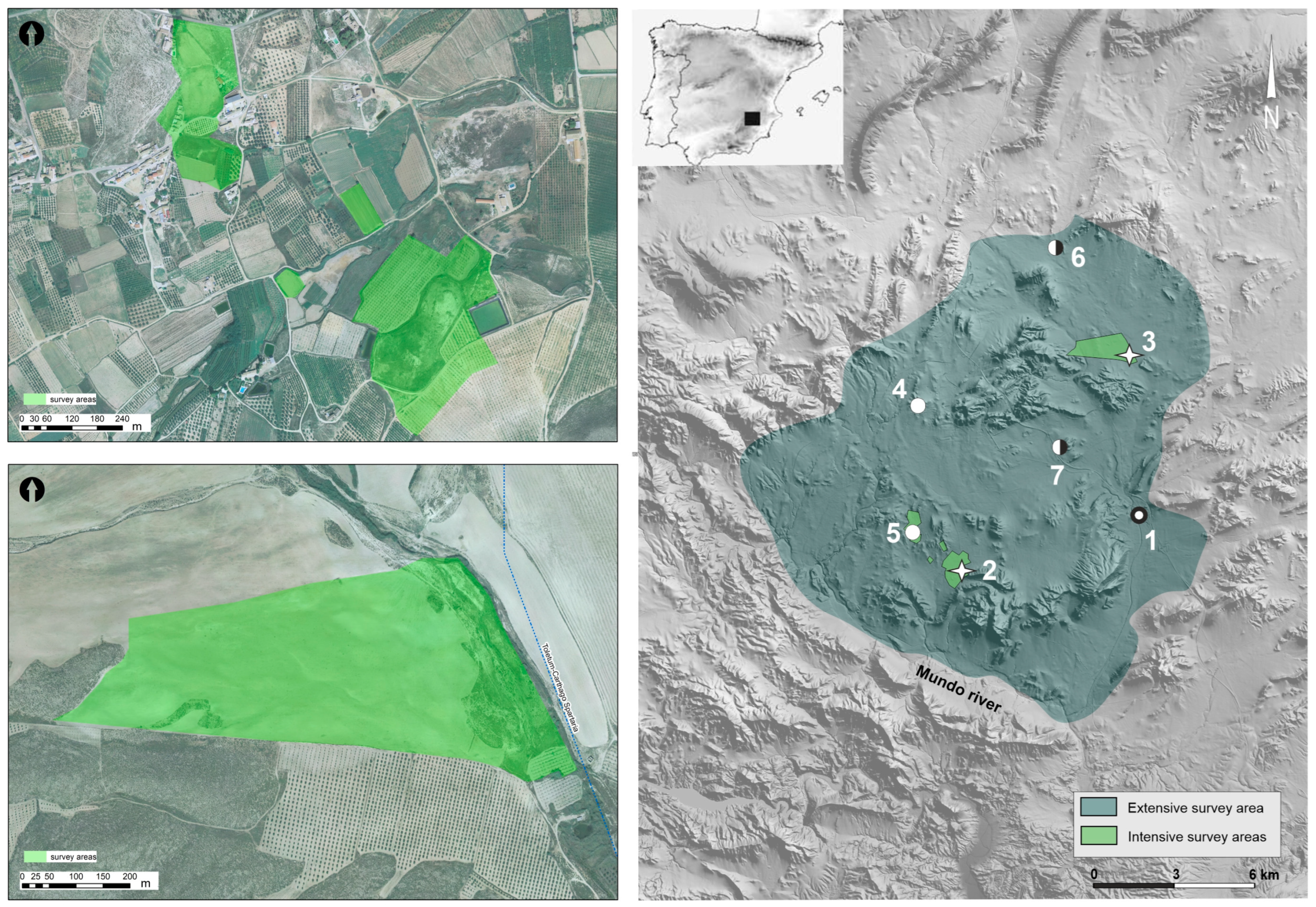
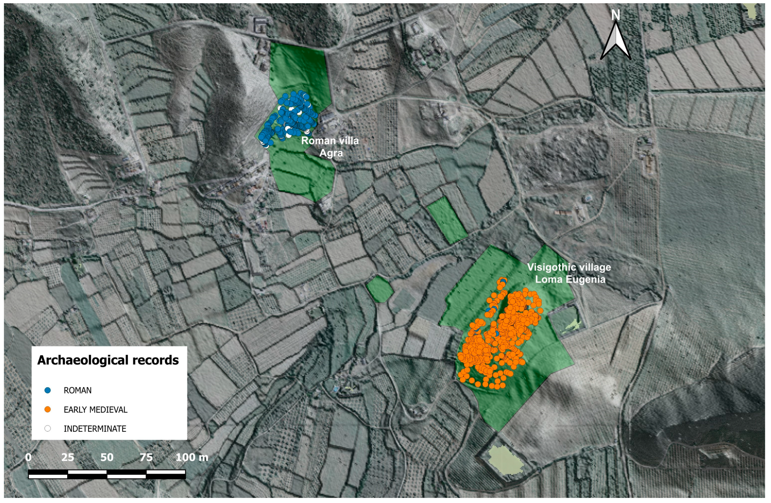
3.1. The Rural Landscapes around Tolmo de Minateda (TM) in the Late Antiquity and Early Middle Ages

The research carried out over the last 30 years in TM has shown the existence of a city from the Late Antiquity and Early Middle Ages, which was built on the remains of the ancient Roman municipality of Ilunum [4]. This city has also been identified as the Visigothic episcopal see of Eio or Elo and the later Islamic madīna of Iyyuh, both of which were of great importance within the geopolitical and historical context of Southeast Hispania between the 7th and 10th centuries [12,13]. Archaeological investigations have traditionally focused on this site because of the depopulated condition of the city and the fact that its archaeological records and transition contexts are so well preserved. For this reason, one of the main archaeological problems that has been faced in recent years is the recognition of the rural settlement patterns and landscape management strategies used in the different periods when TM headed this territorial system, as well as the degree of continuity of Roman structures in the Early Middle Ages [5,7,14,15].
The archaeological data that were available up to the beginning of our research were mainly related to material and structural remains from residences; therefore, they very focused on identifying the forms of settlements, without taking into account evidence from off-site records.

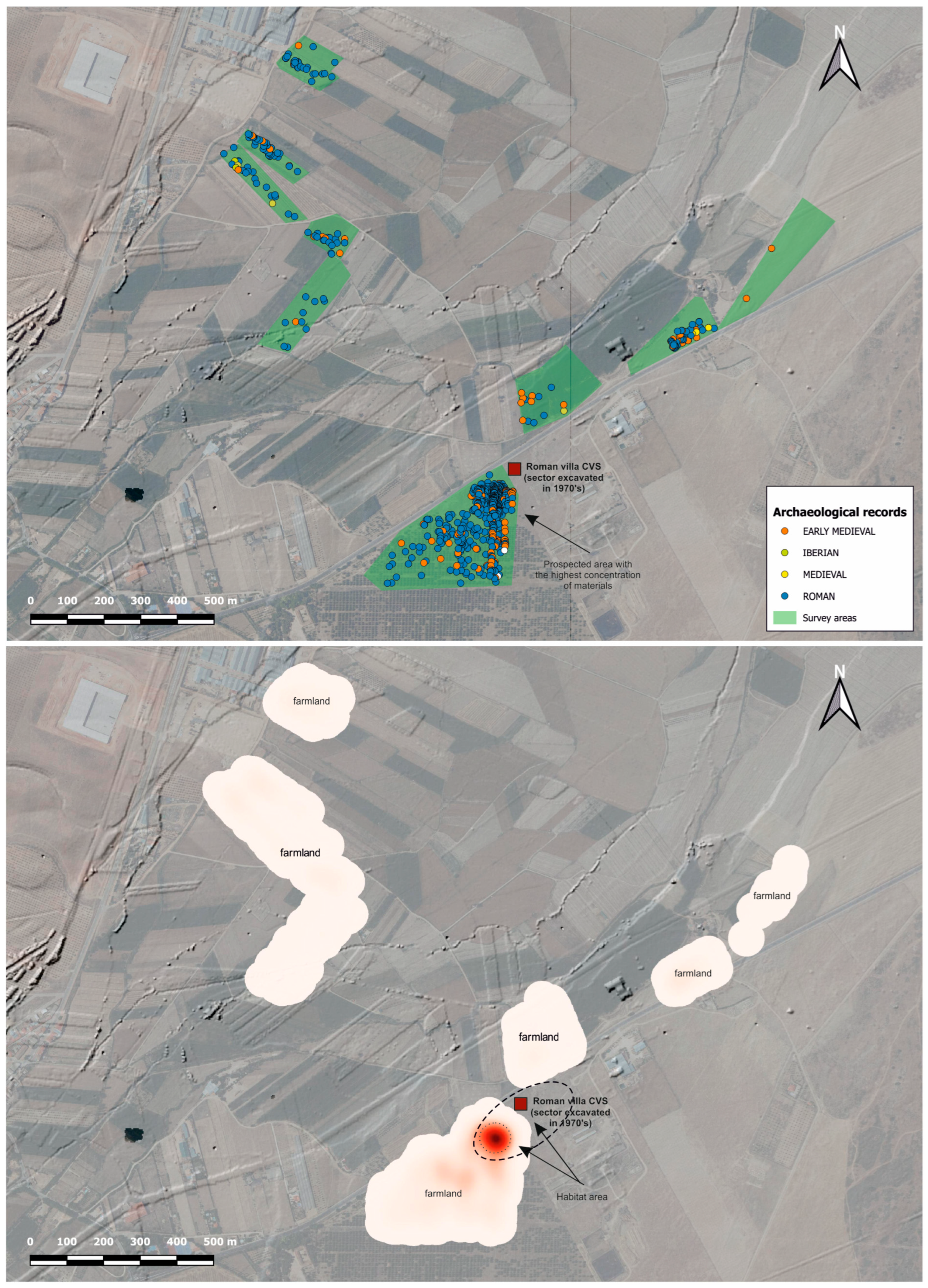
3.1.1. Characterisation of the Analysed Register: Concentrations of Materials without Dispersion Borders

Our work was concentrated in two areas of the TM suburban territory, within about 8–9 km to the north and west of the site. The selected study areas were large flat areas with some hills, which were surrounded by mountains and furrowed by small river branches that converged with the Mundo River. Within each study area, we chose certain spaces according to the topographic study, geomorphological criteria, and archaeological data from our previous work that could potentially specify the continuity of agricultural spaces and landscape management strategies from Roman times to Medieval times. We carried out a full-coverage survey with the aim of identifying and analysing the spatial structures of the surface records (Figure 3). The total area covered during the work was about 50 ha, with a geolocation of 1000 records (understood as every single piece of an archaeological object detected on the surface).
The strategy chosen to map the continuum of possible evidence was off-site registration; however, from the beginning, we could see that the surface records were concentrated in discrete and specific locations, with little dispersion around the sites and practically no records in the rest of the space. Therefore, we decided to reorientate our strategy and site concept, instead focusing our attention on places with potential house remains and verifying the existence of areas that were completely sterile.
The surface records presented a very clear pattern: dense concentrations of material and large intermediate voids. This picture clearly contrasted the records that we observed in the Balazote River Valley case study.
The spatial patterns were also recurrent: the fertile lands around rivers or small streams continued to be occupied, but the specific locations of rural sites did not since practically none of the Roman settlements survived beyond the 3rd and 4th century AD; furthermore, as we describe in the next section, new villages on small hills appeared at the end of the 6th century that replaced the previous settlements (Figure 4).
From the analysis of material concentrations, we observed how the dimensions of the new peasant villages in the Visigothic period (6th–8th centuries AD) were also similar in most cases. The enclaves located in the hills occupied an area between 0.5 and 1 ha. In all cases, the concentrations of ceramics coincided with the existence of structures, which could be recognised on the surface, in topographic anomalies, or from geophysical surveys. Therefore, the surface records seemed to indicate the zones of residence, transformation, storage, and necropolis, but not fields under exploitation.

3.1.2. The Materialisation of a Discontinuous Rural Population Model

Focusing on the settlement patterns identified from our archaeological data, we detected a Roman agrarian landscape in the territorium of Ilunum from around the 1st century AD, to which some farmhouses and numerous villae corresponded [16,17]. The establishments of the rural and suburban elites that articulated the space around the Roman city experienced different evolution patterns from the late ancient times. Some showed some continuity of space, but the most widespread pattern was that after the installation of the Visigothic episcopal see of Eio–Elo at the end of the 6th and the beginning of the 7th century, when a new landscape model was created. In it, in addition to other settlements, such as castra or turris, new forms of concentrated peasant settlements (villages) prevailed on small hills, which generally appeared in new habitat sites around the agricultural spaces that were exploited in Roman times. The occupation of these villages declined after the Islamic conquest, coinciding with the establishment of the Province of Tudmīr in 713 and the installation of the madīna of Iyyuh in TM (Figure 3) [5,7]. Therefore, we encountered some occupation dynamics that could be defined as discontinuous, with the clear abandonment of Roman villae although not of the agrarian spaces or land uses, as the new villages only appeared about 1–2 km away from the previous settlements and continued to exploit the same fields in the same way [7,16,17]. This is probably because they were still the most fertile lands, and the agro-systems were already articulated. The rupture of this pattern and the widespread abandonment of the agrarian landscapes that had historically been exploited occurred after the Islamic conquest of the Iberian Peninsula.
Some examples of this new pattern of occupation could be observed in the well-known villa of Hellín, which did not last beyond the 3rd century. From our surface surveys, geophysical surveys, and the excavation of some specific sites, we could more clearly characterise the creation of new rural settlements around the same time that the episcopal see was installed in TM. On the one hand, we found some examples of higher-ground settlements, such as the possible castrum of Alboraj, which presented some defensive sections, buildings of certain magnitudes, and surface materials with chronological forks between the 6th and the 10th centuries [7] (pp. 223–226).
On the other hand, some of the peasant settlements or villages emerged at the end of the 6th and the beginning of the 7th century, such as Loma Lencina (LL), which was established in a space that was not previously occupied and was probably built for the exploitation of lime. Another example is the case of Loma Eugenia (LE), which was located in an agrarian space that had already been exploited by the ancient Roman villa of Agra, although the village moved to a small hill on the other side of the river.
We especially focused the research on analysing the organisation of the peasant societies in this type of settlement and its relationship with the Visigothic city.
The case of LE was especially interesting because, after a one-off excavation of its necropolis in the 1990s [18] and the surveys carried out by us in recent years (both surface and GPR), a set of materials was recovered that established the provisional chronology from around the end of the 6th century to the mid-8th century [5] (pp. 184–187), [7] (pp. 221–223) and [19] (pp. 162–164).
According to the surface evidence and the results of our geophysical survey, the space occupied by the village did not seem to exceed 6000–9000 m2; moreover, within the terrain, there were some masonry walls with vertical slabs that resembled the domestic Early Middle Age structures that have been documented in TM [5,7]. The residences seemed to be concentrated in the southern and central areas of the hill surface, while the necropolis area of the peasant community that lived in the village was located to the north. The cemetery included a series of burials with a west–east orientation. In the partial excavation in 1995, 33 graves were exhumed and were found to have been buried in earth, lined and covered with slabs and, in some cases, masonry to join the slabs and regularise the graves (Figure 5). We could not specify the number of individuals in each tomb, but they were mostly reused burials. Among the grave goods were two bronze rings, a possible leather tanner, and three belt buckles dated between the late 6th and 7th centuries [20] (p. 69). Absolute radiocarbon dating was also performed on one of the individuals found in one of these tombs (grave 6), which offered us a chronology of 676–779 cal AD (1274–1171 cal BP, Beta-572260). This necropolis was only partially investigated; however, according to the remains on the surface, it was a cemetery plot with a surface area of about 3000 m2. Taking into account the excavated sector that had a surface area of about 1000 m2, the necropolis could have held 100 tombs, which were probably reused on several occasions. Therefore, we identified a rural community of medium size, with a single necropolis detected so far, in which some items of personal clothing were found.
On the basis of all this evidence, we recently carried out excavations in two areas: one was located in the village and the other was located in the necropolis. The work carried out in the first campaign allowed us to detect a large room in the area of the village, where the sequence of occupation corresponded to the Visigothic period and did not extend beyond the middle of the 8th century. The room was very similar to those in other Visigothic villages that have been excavated in the centre of Madrid, such as the village of “Gózquez de Abajo”, where domestic buildings have been found that included spaces for storage or production [21]. This could also be the case with the room documented in LE, which seems to include a fireplace or combustion structure (Figure 6).
As can be seen in Figure 7, the room also seemed to extend northwards; hence, this could corroborate the existence of a building with several rooms and walls of great technical quality and significant dimensions, including spaces for productive activities. In the necropolis, we also excavated one of the tombs that remained intact, which turned out to be a reused tomb containing three individuals. The last individual buried was a teenager with a radiocarbon dating of between 772–825 cal AD (1178–1025 cal BP, Beta-643123), under which was a pregnant woman with the remains of a foetus in her womb and another adult individual who had been placed in a secondary position when the other two individuals had been buried (Figure 7). Again, the configuration of the necropolis and the fact that the tombs were reused reinforced the idea that we had identified a peasant community who buried their dead in the necropolis for at least three generations.

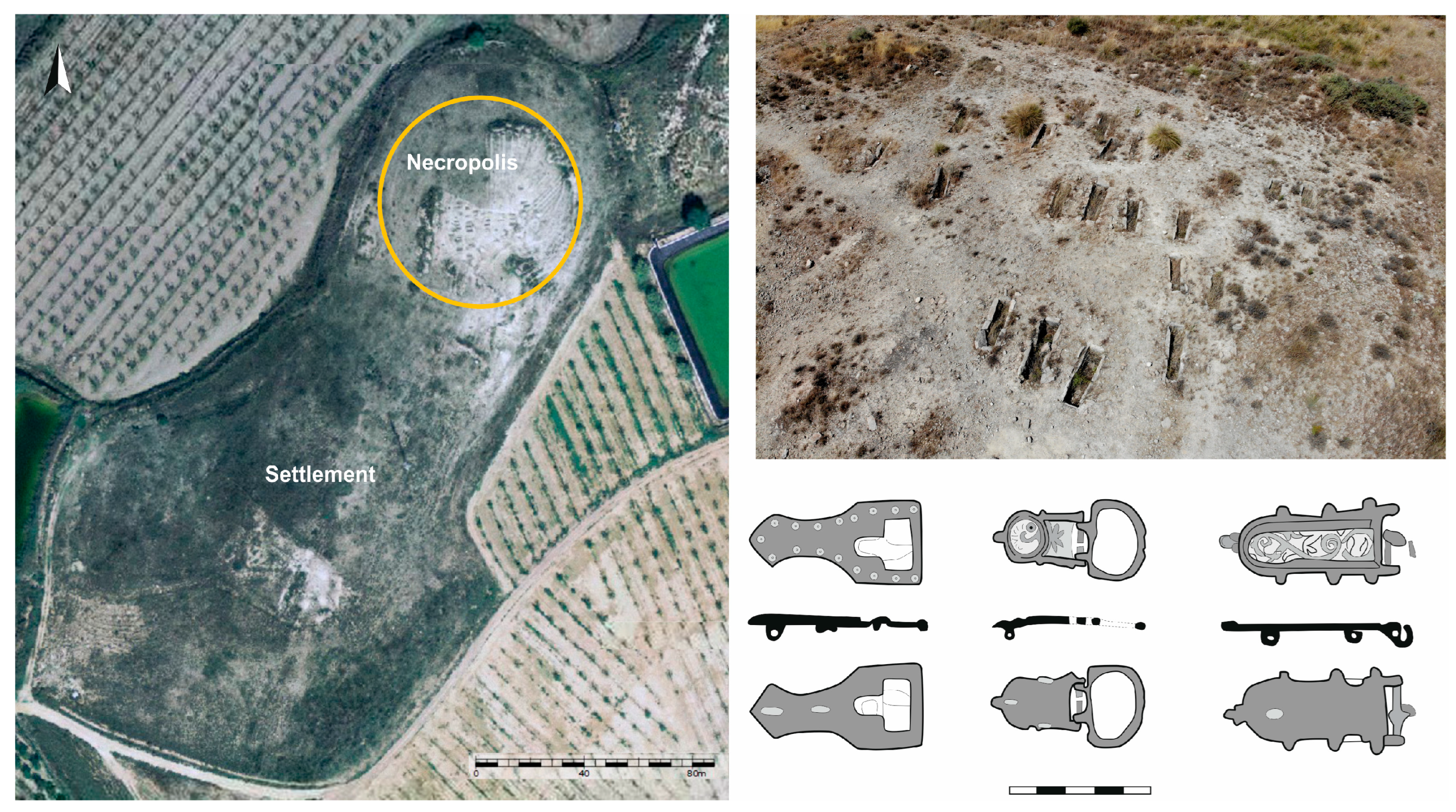
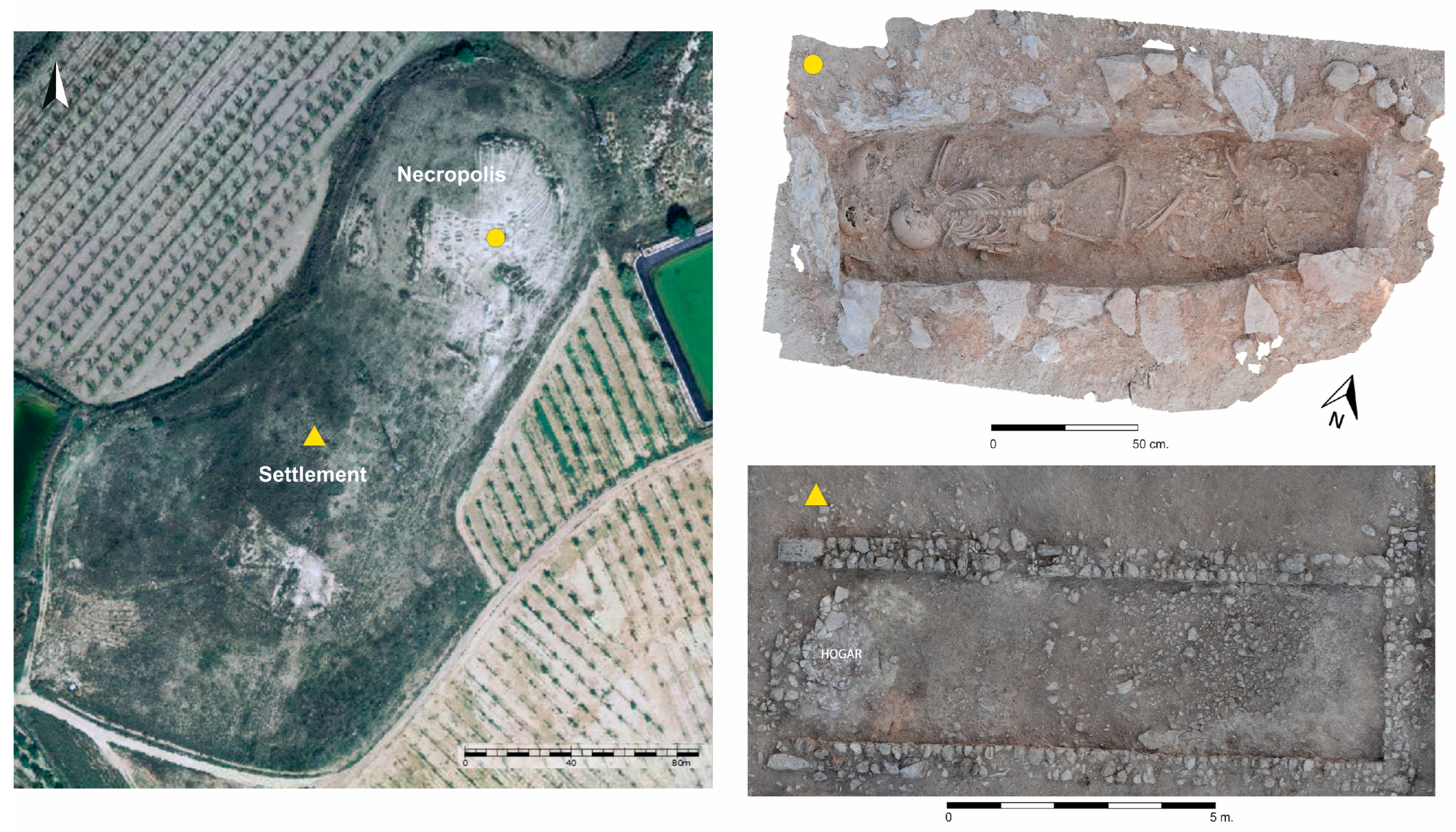
3.2. A Model of an Agrarian Settlement of Great Resilience: The Case of the Ancient Roman Villa of El Camino Viejo de las Sepulturas (CVS)

The Balazote River Valley is a wide endorheic area bounded to the east by the western edge of the “Llanos de Albacete” and to the west by the elevations of the “Campo de Montiel”. The Balazote River, where small lagoons, wells, and water courses converge, has created a low-altitude (between 780 and 800 m) valley of alluvial soil that slopes slightly towards the river. These abundant water resources have made the land fertile and, together with the semi-arid continental Mediterranean climate, have helped to support intensive agriculture practices in the fertile plains, including extensive grain agriculture (currently mostly barley) and viticulture, along with an important livestock tradition on the grasslands of the nearby hills. Unlike the TM landscape, the surface records analysed after our survey in this valley showed extensive concentrations of materials from various periods with varying densities, which were concentrated in specific settlements or enclaves [2]. Beyond these sites and their agricultural spaces, there were areas that were empty of materials. For this reason, our research in this study area focused on thoroughly mapping and analysing the surface and subsurface evidence from one of these enclaves (CVS). In the 7.75 ha prospected using our intensive strategy (selected fields were used as sampling units to cover a large area), we geolocated more than 5000 items from different periods (Figure 8). More than 3000 items were diagnostic materials that showed a long sequence of uninterrupted occupation from the 1st century to the 11th century AD.

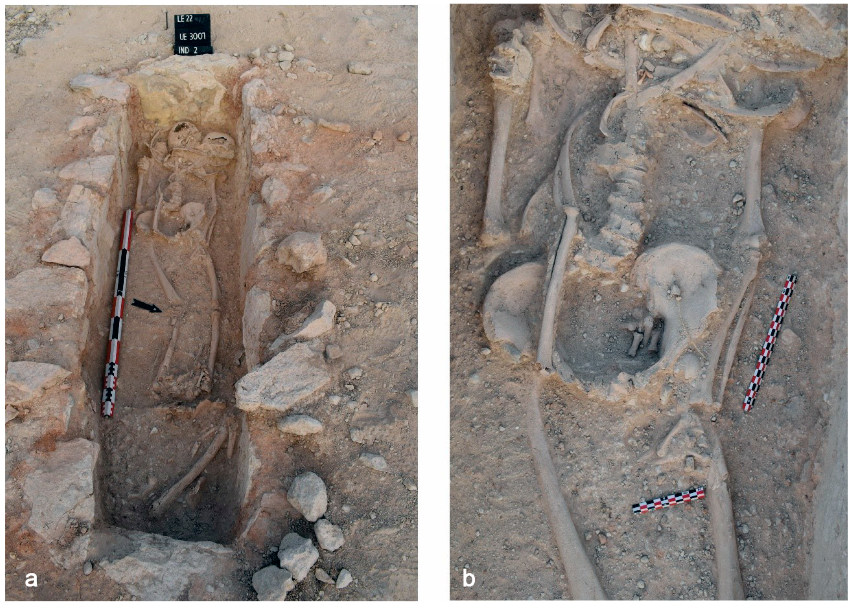
3.2.1. Long-Term Occupation Dynamics at CVS

From the historical point of view, this region was linked to the Colonia Libisosa Foroaugustana in Roman times [22], which was a city that administered a large territory in which the establishment of villae and some mansiones was quite early [17]. We did not have many archaeological data on the evolution of these villae from the Late Antiquity and Early Middle Ages; however, after the abandonment of the city during the late Roman Empire, it seems that many of these settlements continued to be inhabited to a greater or lesser extent, albeit obviously losing their “aristocratic” character. At this time, the structures were transformed according to the new needs of the peasant communities that settled in the buildings after the widespread abandonment of the small and medium farmhouses located near of these villae. The goal was to seek security under the protection of these larger establishments.
This process was detected at the CVS site, where the excavation campaigns carried out in the 1970s exposed part of a large Roman villa, with several phases of occupation and transformation [23]. In addition to the structures discovered at that time, there were others found in specific interventions, which confirmed the extensive occupation of this area in the Roman, Late Antiquity, and the Early Middle Age periods [6,24,25]. In short, the origins of this settlement could be traced back to the 1st century AD, when colony status was granted to the city of Libisosa (located about 20 km away), to which administrative territory this rural complex belonged. This original phase was followed by a phase of development and monumentalisation in the Late Roman Empire, which provided a great number of remains during the excavations. After this period of prosperity, from the end of the 4th century and throughout the 5th century, some rooms began to be abandoned, and only those that could be used as domestic environments were occupied, in which cooking areas, storage/production areas, or even tombs were installed (Figure 9).
The phase of occupation in which the residential areas were reduced and transformed seemed to be linked to the installation of peasant populations in the surrounding areas of the site and when the old Late Roman elites abandoned these types of rural establishments as places of residence [26]. This new rural pattern gradually consolidated, as evidenced by the appearance of a community necropolis in the vicinity of the old villa, which implied the existence of a stable community that buried their dead for several generations. The radiocarbon dating of this necropolis ranged from the mid-7th century to at least the 11th century [27].
In order to sort all these partial data and begin to understand the dynamics of occupation of the ancient Roman villa of Balazote, we reconnoitred the evidence from the territory in which the settlement was located using surface surveys and geophysical surveys and proved the resilience of this fertile landscape, at least until the Islamic Caliphate period (10th–11th century) [2]. We began the research with a surface survey, from which the concentrations of materials allowed us to obtain a provisional chronology of post-classical contexts that oscillated between the middle of the 5th century and the 11th century. After this surface survey, we conducted geophysical prospecting using GPR in the areas with the highest concentrations of materials. The data extracted from this exploration showed structural testimonies in the subsoil, both to the west of the excavated spaces in the old roman villa and in slightly more distant areas, which supported our location hypothesis of a settlement in the Late Antiquity and Early Middle Ages. These structures were shallower and had a different orientation to those detected in the Roman villa (Figure 10). This settlement was related to the necropolis with Visigothic and Islamic tombs, which was located about 150 m to the northeast.
In order to verify and clarify the results obtained in the surveys, we began the excavation of a new sector to the west of the domestic spaces that had already been excavated in the 1970s. We documented new rooms related to Roman monumental housing, as well as new resurfacing and repairs from the late 4th and early 5th centuries, and evidence of use and construction from the occupation phases in the Late Antiquity and Medieval times. These later phases seemed to relate to the productive and domestic reoccupation of old rooms around the end of the 5th–6th centuries until the 10th century, with the construction of new walls that reduced and compartmentalised the rooms, silos for storage carved into the pavements of the opus signinum of the roman villa, and combustion structures, which demonstrated the installation of peasants in the ancient villa who buried their dead in the nearby necropolis that showed the same chronologies (Figure 11). This period of occupation related to a possible Visigothic village and a later Islamic settlement, which was followed by a phase of Medieval Islamic plundering before the definitive abandonment of the old village around the 11th century.

3.2.2. Land Use: Examples of Long-Term Sustainable Uses

Beyond these spaces that we interpreted as residential areas from different eras, we found fainter dispersions of materials in which ceramic fragments from ancient and Medieval times were intermingled with varying proportions, according to the counts of diagnostic pieces and the total counts from some plots. We interpreted these scattered remains as evidence of agricultural practices (the fields with the highest concentration of materials are interpreted as fertilisation remains with domestic waste), which allowed us to more precisely define the perimeters of cultivated fields during the two historical macro-periods (Roman and Medieval) that marked the transformation of the agrarian landscape of CVS.
According to our off-site registration, the agricultural areas located in the fertile river basin at the foot of the settlement had a perimeter between 200 and 230 ha in the ancient period. From these data and those from other nearby spaces, we proposed the existence of intensive agricultural practices according to the exploitation of plots or orchards that did not exceed 2–3 ha and were located near the settlement, which would work with other types of agricultural practices, such as the extensive cultivation of grains and pastures, more focused on the market needs of the people from the villa.
The off-site data corresponding to the Medieval period showed the continuity of the old intensive agricultural spaces, with a cultivated area of about 200 ha. However, at this time, it seems that the drylands from around the Early Middle Ages and Islamic settlement were reduced, which indicated a change in the model of the exploitation of agricultural landscapes that was probably connected to a change in the social organisation of the villa around the 5th century.

4. Discussion

4.1. Dynamics of Rural Occupation between Abandonment and Resilience: A Proposal of Determining Factors

As previously described, the surveys allowed us to identify and analyse the rural spaces of two different areas on the Iberian Peninsula, which had similar historical dynamics but markedly different socioecological systems. The application of identical methods allowed us to compare the different spatial structures of these two regions.
The results of this comparative exercise showed us clear differences in population patterns, as well as in agrarian practices and exploitation systems. Regarding settlement patterns, a similar typology of villages was found, although with significant variations in the duration of occupation. Compared to the model of the “Campos de Hellín”, where rural villages rarely lasted more than one cultural phase, the occupation in the Balazote River Valley was much more resilient, occupying the same spaces during different historical phases (Figure 12).
The duration of occupation seemed to be affected by several factors that were opposed between the two rural landscapes.

4.1.1. Geopolitical and Historical Factors

In the case of “Campos de Hellín”, the archaeological data showed territory occupation dynamics that were intricately linked to the city in TM. This city functioned as the epicentre from which a hierarchised rural landscape was developed in Roman times, which continued through Late Antiquity and the Early Middle Ages when it became a Visigothic episcopal see in the 7th century and an Islamic madīna in the 8th century [4]. From the episcopal see, the old and new rural settlements that were distributed within its diocese were managed and in Islamic times, it seems that the rural landscape was transformed definitively due to the abandonment of the old rural settlements from the Visigothic period [2,5,7,15]. The creation of new settlements was not documented until at least the 10th century, when the city was definitively abandoned.
Therefore, from the geopolitical and historical points of view, the development and evolution of rural settlements in the countryside of TM were clearly linked to the different powers established in the city, from its foundation as a Roman municipality until its definitive abandonment at the beginning of the 10th century. A crucial fact was that the documented Late Antiquity villages (i.e., LL and LE, among others) were installed at the same time that the episcopal see was established in TM. This undoubtedly corresponded to the need for the bishopric of Eio to generate stable farming villages, in which productive agrarian activities could be concentrated and from which produce could be redistributed to rural markets and the city, probably via the payment of taxes. This hypothesis could explain the fact that, at the time of the conquest and after the configuration of the Islamic province of Tudmīr in 713, these villages began to be abandoned as the old fiscal role of the bishopric was lost, perhaps encouraging the population to settle in the new Islamic site of Iyyuh. The city at the end of the 8th and the beginning of the 9th century was fully Islamised and had a densified and rural urban fabric, with domestic spaces and other productive environments distributed around the surface of the hill, such as oil mills and corrals [13]. The abandonment of the agrarian settlement model around the mid-8th century was not detected in the examples of higher-ground settlements or castra that we found, which remained occupied until the beginning of the 10th century, as with the Islamic city itself. This reinforced the idea of the importance of the higher-ground settlements within the rural landscape of Hispania around the 5th and 6th centuries since various sources have cited that they, together with civitates, were key to the strategic and fiscal control of the territory. In fact, in 711, the castra constituted the main type of rural settlement for Visigothic aristocracies, which had previously settled in episcopal sees and cities until the agreements of surrender with the Arabs had been established [28], undoubtedly leading to the durability of these settlements beyond the convulsive 8th century.
In contrast to this area, which was clearly linked to the historical development of the city in TM, in the case of the Balazote River Valley, we recognised the implementation of a Late Antiquity and Early Middle Ages rural settlement pattern, which had a high degree of continuity from the ancient Roman settlement [2]. Along with the other economic, environmental, and social factors that we describe below, we hypothesised that the continuity of these residential and agricultural spaces was significantly linked to the peripheral character of this region with respect to the nearest city because, after the abandonment of the Roman city of Libisosa around the 3rd century AD, the nearest centre was TM, which was located about 70 km away and, therefore, was outside regional control.
The archaeological data from CVS showed a long continuity in the sequence of the occupation of the ancient villa, albeit with different functionalities and physiognomies. The final moments of this settlement were when it was known as Balāt al-Şūf (the origin of the name Balazote), as cited by Arab sources [29] (p. 223), the first mention of which was during the Caliphate period (year 935) and which some authors have referred to as “Calzada de la Lana” (woollen driveway) [30] (p. 359). This could have been related to the important trade of this product in Islamic times, which, together with the intensive agricultural practices developed secularly in the fertile plains, resulted in the resilience and historical sustainability of this space. This settlement was abandoned during a time of territorial instability that was caused by the civil war or Fitna of Al-Andalus (1009–1031), which ended the Caliphate of Cordoba.

4.1.2. Economic Factors (Farm Models)

Beyond the archaeology of the settlements detected in both regions, we also examined the nature of land uses and agrarian practices using archaeological indicators that were related to the spatial structures of the surface records.
A whole series of geographical and anthropological studies on the investigation of Mediterranean landscapes have indicated the deployment of two economic strategies, according to the forms of land exploitation [31,32,33]. One strategy is defined by an extensive type of agriculture, which is based on the development of dryland and fallow farming, with some importance placed on grazing. The number of work hours required for this type of agriculture is not very high per unit of surface area, which allows it to be applied for large fields that practically do not need to be fertilised. In contrast, there is an intensive strategy, which is based on crop rotation and irrigation. This tillage requires constant work in the fields, especially for the maintenance of high levels of soil fertility through irrigation or the incorporation of organic fertilisers. Livestock farming is a fundamental complement to this type of agriculture and provides essential manure to maintain the fertility of the fields. In the case of intensive agriculture, proximity to the farmland facilitates this constant work, meaning that most of the peasant work is tied to agricultural practices and not displacement. Therefore, there is a clear correlation between management models and the locations of farmland [11].
The results of our fieldwork showed a clear contrast between the two case studies of Hellín and Balazote, which was undoubtedly linked to clearly different land uses and different forms of field management, as well as the presence or absence of off-site ceramic records. Due to the agricultural modalities offered by the absence of off-site registration around the villages of “Campos de Hellín”, the economic orientation of peasant communities towards extensive grain agriculture and livestock seemed evident. Meanwhile, the archaeological indicators that showed the existence of an intensive agricultural model in Balazote were due to the detection of off-site ceramic materials, i.e., they were not directly associated with places of residence, according to the decomposition of the primary archaeological deposits.
We did not find any accurate archaeobotanical information in the landscape around TM, but the palynological analyses of nearby areas, as well as the indications of traditional uses prior to the mechanisation of farming in the 18th century, indicated the presence of crop fields intended for the cultivation of barley (Hordeum vulgare) and nude wheat (Triticum aestivum/durum), which are plants suitable for dry climates and saline soils [34,35]. These agricultural practices were combined with the cultivation of other complementary crops (such as cherries (Prunus avium/cerasus) or acorns (Quercus)), but no evidence was found of vegetable cultivation; however, evidence for livestock management was clear. Livestock farming was one of the main economic activities in this area as it was very suitable for this type of exploitation due to the suitability of the pastures, the abundant low vegetation, and the existence of numerous sources of fresh water, as well as the ease of access to salt in some salt marsh spaces (such as Alboraj-Cordovilla), which is an indispensable element in livestock diets [36].
For this region, the information provided by the Cadastre of Ensenada (18th century) was of great interest as it expressly states that, during its drafting, new plots were developed for cultivation: 14 plots were “taken from the meadow”, 85 were in low mountain areas, and one was in a high–low mountain area. The surface area of cultivated land was only 17.83% of the Hellín area, according to the Cadastre [36] (p. 748). This suggested that, until the 18th century, land in the area was mostly low-lying vegetation, grasslands, a moderate degree of farmland, and vineyards or olive groves, along with trough spaces that were not occupied by stagnations [37]. The coexistence of the mountains (with conifers or scrub vegetation, depending on the area) and the small arable areas contributed to the main historical uses of these lands, which were mainly orientated towards livestock [38].
A few historical sources have Indicated that livestock has been considered one of the main resources of the area since at least the Middle Ages. The first known records were from 1576 (topographic listings for Philip II), when the authorities of the Hellín area made an agricultural catalogue at the request of the king, which included mulberry crops, raisin and wine vineyards, and some fruit trees [39] (pp. 40, 65). It has also been pointed out that the land was “mountainous and uncultivated due to its roughness, which is only good for pastures, and firewood”. Referring to areas close to Hellín that were in the studied region, the catalogue sent to the king stated that the mountains “are very populated with firewood, pines, rosemary, sabina, junipers, and gorse… There are also many pastures for cattle…” [40] (p. 211). Due to the presence of grasslands, it was necessary to move livestock activity, which would target the barley crops, fodder, etc., and which, in the 18th and 19th century, included about 1800 heads of wool livestock [39] (pp. 65, 89).
In short, according to the agricultural modalities presented in all of these sources, as well as our archaeological data from “Campos de Hellín”, it seemed that this region traditionally focused on extensive grain farming and, above all, the management of livestock herds, which is an area that is historically related to transhumance, where “Cañadas reales” or droves are even preserved to this day. These land uses leave little or no macroscopic archaeological footprints on the ground; hence, we did not find any off-site ceramic evidence on the surface, which was instead only found when the intensive land uses were fertilised with household waste. This type of activity allowed peasant communities to move to more favourable spaces or as indicated by local authorities because not much work was required for these extensive agricultural practices.
In contrast to the extensive model of the Hellín territory, which was based on dryland crops and livestock, in the case of the Balazote River Valley, we detected an intensive model of plots with contiguous tillage. Most likely, the high amounts of work required to build, condition, and maintain agricultural fields could explain the multigenerational links between certain groups and certain plots and, therefore, the permanence of some settlements, such as CVS, which experienced an uninterrupted occupation for a millennium (from the 1st to the 11th centuries AD), despite the change in the model of occupation around the 5th century (from a large Roman villa or hacienda to a Medieval peasant village).
This continuity of the CVS settlement indicated the clear fixation of the populations that occupied this area of the Balazote River Valley to the land and, therefore, the maintenance of the intensive agricultural management modality by these communities, which led them to systematically occupy the spaces near the river valley, where the potentially irrigated fields were located. Thus, there was clear evidence of the uses and management of the agricultural landscapes that have been maintained over the centuries, including the logical modifications of irrigation infrastructures and the morphologies of the fields.
During the Roman period, we hypothesised the existence of an intensive agriculture model that was based on the exploitation of small and medium plots and the extensive agriculture of grains, which probably occupied large areas, along with pastures. This agricultural model was most likely based on a mixture of grain and legume crops, as well as the cultivation of fruit trees, vines, and olives [35].
During the medieval period, the CVS off-site records showed the continuity of the ancient intensive farming spaces; however, at this time, it seemed that the fields destined for dryland farming or extensive cultivation were reduced. The amount of fertiliser available from the generation of household waste and animal manure was directly related to the size of the community and the available livestock herds. In the case of CVS, the more or less stable maintenance of intensive farming practices, both in Roman and in Medieval times, indicated the use of similar amounts of fertiliser and fairly large livestock herds, when taking into account the surface area (between 200–230 ha) of the intensive farming fields around the fertile plains near the site.
However, judging by the surface area of the residential zone and the dryland agricultural space of the settlement in Late Antiquity, we hypothesised that the post-classical village of CVS was formed by a medium-sized community that maintained small cereal plots for subsistence and produced surplus resources for local or regional exchange and for feeding livestock, which was demonstrated by the presence of silos inside domestic spaces during this late phase. The capacity of these silos ranged from 700 to 750 L.
The extraordinary attachment of the peasant communities that settled in this space to the land and intensive agricultural practices was undoubtable. These communities were first the dependents of Roman landowning families that managed large agricultural haciendas and large expanses of dryland and irrigated fields; then, from the beginning of the Middle Ages, rural communities with some autonomy settled in the medium-sized units of these settlements, such as the Visigothic village and the later Islamic village of Balāt al-Şūf, which had its own irrigated area of several hectares. This again demonstrated the existence of a special relationship between peasant settlements and the construction of work and residence spaces and the exploitation of the environment.

4.1.3. Social Factors

The different settlement patterns and agrarian models detected in both areas at different times were also related to other questions about the forms of social organisation and the legitimacy, ownership, and use of the land, which, although they have eluded archaeological reality, were related to other issues and could be identified using appropriate anthropological models. In this sense, the fact that certain human groups were linked to certain spaces for centuries could be due to the development of intensive farming practices, such as those detected in Balazote. This is because it is a strategy that involves high levels of dedication from farmers to their agricultural work in order to increase or maintain the production per unit of land [41]. This strategy also requires higher labour and/or capital costs [42]. The fertilisation of land and the construction of agro-engineering facilities, such as terraces or irrigation canals, are the most common forms of intensification [43]. The extension of the growing season, the introduction of new crops, and changes in the patterns of the organisation of community work are also considered to be forms of intensification [44]. Thus, agricultural intensification was defined in this study as any increase in the amount of labour per unit of land that increased production or minimised a decline in production [1]. Additionally, the investment of time and effort required by these practices meant that they developed over more or less prolonged periods of time, unlike other socioecological systems, such as those detected in “Campos de Hellín”, where only extensive practices and livestock activities were identified.
The detailed analyses of the causes and different trajectories of intensification presented in other works allowed us to discuss its significance in relation to the forms of socioeconomic organisation among the communities installed secularly in CVS [45].
There are several theories to explain why communities begin to develop intensive farming practices and dedicate great amounts of effort to conditioning and maintaining fields. One of the main theories concerns population growth, which could lead to demographic pressure on resources and the need for agricultural intensification [43,46]. In this context, farmers reduce fallow land and maximise their land use or develop agro-engineering facilities. In our case study, it was unlikely that population growth was the cause of any intensification since the agrarian colonisation of the fertile plains around the Balazote River was only detected since the original installation of the Roman villa in the early imperial era; hence, demographic saturation could be ruled out. Other variables that play key roles in intensification have also been proposed, such as social demands and the payment of taxes related to political economies or trade. These variables could be related to the Roman phase of the settlement, when, in addition to intensive orchard farming with large concentrations of materials, other extensive land uses were detected that were undoubtedly related to the latifundia model, which is traditionally attributed to rustic Roman haciendas or villae.
However, this model of the socioeconomic organisation of agricultural work, in which the farmers who were dependent on the possessores of the villa carried out the intensive and extensive management of the fields, seemed to change following the dismemberment of the Roman State. From the 5th century onwards, we detected a clear reduction in dryland land uses and a concentration of agricultural work in intensive cultivation fields. From then on, we observed a continuity of the settlement, but with clear transformations in the type of settlement. There was a reduction in residential space and an increase in domestic and storage structures, which were linked to the installation of a peasant community that was probably generated after the integration of groups who had been installed in both the old Roman hacienda and the surrounding farmhouses that were abandoned [47]. This integration was a phenomenon that was widely observed in other regions of Hispania and could be explained by the instability and the lack of security caused by the crisis of the Roman Empire and the fall of classical territorial structures, among other things. These concentrated settlements or villages followed the social organisation model of communities based on nuclear or polygynic family groups, which are understood to be the social units that normally mobilise work activities, organise consumption, and exercise ownership over small plots of land that are intensively cultivated. In the case of CVS, the archaeological interventions were very recent and did not allow us to understand the extensions to the structure of the village; however, in other nearby cases, such as “Gózquez de Abajo” in Madrid, productive spaces, storage spaces, and plots for vegetable and cereal cultivation have been detected around each domestic unit [21]. These agricultural plots seem to have been distributed and assigned to each family unit within the community from the initial phase of the settlement until its abandonment. Trenches, roads, and aligned structures have allowed us to discern the shape and size of each plot. Each household occupied about 0.6 ha, comprising both land for the house and land for agricultural cultivation. Zooarchaeological and archaeobotanical analyses of samples from Gózquez have provided interesting data related to production and cultivation patterns, showing a balance between livestock and agricultural practices that, together with the systematic appearance of silos (each household had between four and six silos), certainly allowed for the production of a surplus that benefited both the family groups and the community. In this sense, Wickham [48] identified a peasant model of production among Early Middle Ages agrarian societies, which was based on the fact that the central element of the production process was the home, meaning that all members of the group worked but the accumulation of goods and the constitution of an estate were not essential concerns, nor was the response to the requests of a master, which differentiated this model from the slavery model of the Roman period and the feudal model of production. Additionally, he reported that there were no clear signs of social hierarchies or differences in wealth between different households. This social model best fitted our specific case study. Between the 5th and 8th centuries, the predominant role of the CVS village was due to the initiatives of small peasant groups that did not have strict dependences on external factors. Although these groups had connections to neighbouring regions through political structures and exchange networks, their economic activity was orientated towards satisfying their own needs and the perpetuation of their own communities through continuous investment.
This model of social organisation was maintained during the process of Islamisation that led to the Arab–Berber conquest of the Iberian Peninsula, throughout which the old Visigothic village continued to be in use and was probably occupied by the same family groups that adapted their socioecological systems to the new cultural and productive dynamics introduced by the Umayyads [2,19]. This could be assumed due to the archaeological records that were found in the necropolis located to the northeast of the settlement, where we detected the continued use of the same burial space from Late Antiquity to Medieval Islamic times. This continuity of the cemetery, together with the fact that stable isotope analyses carried out on individuals buried in the 7th and 9th centuries indicated similar consumption patterns (i.e., the preferential consumption of plants without the consumption of new crops introduced by Arab populations), demonstrated that different generations of the same family groups had become Muslim [27]. Agricultural work continued to be based on the intensive model, but the labour investment decreased with the installation of new hydraulic technologies that facilitated the fertilisation of the land [1].

5. Conclusions

As revealed in this paper, the investigations carried out so far on the selected areas have allowed us to identify and analyse the spatial structures of Late Antiquity and Medieval landscapes, including a city that functioned as the administrative head of a historical territory for several centuries and the peripheral area where urban dynamics did not directly influence the configuration and development of rural populations.
With regard to the settlement patterns that emerged from the 5th century, there were certain similarities in both cases since the type of rural settlement that was predominant from Late Antiquity was fundamentally the concentrated peasant settlement (village), which usually developed around ancient Roman villae or directly on them. In the case of the area near the city of TM, it seemed clear that these villages developed at the same time as the city became an episcopal see and, therefore, the epicentre of an administrative territory; furthermore, its occupation was dictated by the greater or lesser political importance of the city. This was why the villages around TM were abandoned at the same time as the city ceased to be a bishopric after the Islamic conquest and its incorporation as a territory of the Tudmīr Cora. Meanwhile, in the peripheral area of Balazote, the villages were established in ancient settlements and lasted for centuries, in more or less the same forms. The stability and fixation on the land shown by the peripheral peasant communities seemed to be explained by the models of agricultural exploitation that were deployed in those areas, in addition to the very condition of the urban peripheries of the territories they occupied.
Our analyses of the detailed records of the scattered remains in the fields near the CVS settlement in Balazote suggested the continued use of fertilisation practices related to intensive agriculture in those plots; hence, there were concentrations of materials from different periods that indicated the use of household waste to fertilise the fields. These peasant groups fundamentally based their productive structures on self-consumption and their operational structures on family labour. They deployed extraordinarily sustainable and autonomous land-use management strategies with respect to the control of regional or central powers, which remained stable from Roman times until at least the Middle Ages. Most likely, the high amounts of work required to build, condition, and maintain these intensive agricultural spaces could explain the multigenerational links between these groups and certain agrosystems.
In terms of this type of long-term settlement with extraordinary political and economic autonomy, we found evidence of the Late Antiquity and Medieval rural settlement model in TM, as the intensive surveys we conducted around the villages of LE and LL did not reveal any off-site records, meaning that the economies of these settlements were based mainly on the extensive cultivation of grain, which did not need to be fertilised, and livestock. There was also a clear fiscal and commercial relationship with the bishopric of Eio, to which these peasant communities supplied resources, at least until the middle of the 8th century, when they were abandoned. This also demonstrated a link to the religious power that administered these territories until the arrival of the Arab and Berber conquerors.

Author Contributions

J.S.-B. (University of Alicante) is a full lecturer of archaeology in the Department of Prehistory, Archaeology, Ancient History, and Greek and Latin Philology, as well as a researcher at the University Institute for Research in Archaeology and Historical Heritage (INAPH) at the University of Alicante. Her main research focuses on the organisation and transformation of cultural landscapes on the Iberian Peninsula and in northern Italy around Late Antiquity and the Early Middle Ages. She is currently conducting multidisciplinary research on several rural settlements in the southeast of Spain, where she is characterising new settlement patterns and production strategies that were developed after the end of the Roman villa model. The author read and agreed to the published version of the manuscript.

Funding

This research was funded by the “Ministerio de Ciencia e Innovación de España” (grant number: PID2019-108192GB-100/AEI/10.13039/501100011033). CONTEXT: El contexto como herramienta. Escalas de aplicación en los procesos de cambio en el Alta Edad Media.

Data Availability Statement

The data presented in this study are available upon request from the corresponding author. The data is not publicly available because it is currently being processed to include it in a public repository of the University of Alicante.

Acknowledgments

The research presented here was carried out between 2019 and 2022 by a team of researchers from INAPH, University of Alicante. The author would like to thank her colleagues who collaborated with her on the archaeological fieldwork. The author would also like to thank to the municipalities of Balazote and Hellín for the help they provided during this research.

Conflicts of Interest

The author declares no conflict of interest. The funders had no role in the design of the study, in the collection, analyses or interpretation of data, in the writing of the manuscript or in the decision to publish the results.

References

  1. Grau Mira, I.; Sarabia-Bautista, J. Multiscaled Archaeological Survey in Eastern Iberia: Ancient Settlement Dynamics, Agrarian Practices, and Rural Landscapes. J. Field Archaeol. 2022, 47, 471–485. [Google Scholar] [CrossRef]
  2. Sarabia-Bautista, J. El paisaje rural tardoantiguo y altomedieval en torno a la antigua villa romana de Balazote (Albacete, España): Detección y primeras reflexiones. In Paisajes, Espacios y Materialidades: Arqueología Rural Altomedieval en la Península Ibérica; Prata, S., Cuesta-Gómez, F., Tente, C., Eds.; Archaeopress Access Archaeology: Oxford, UK, 2022; pp. 152–165. [Google Scholar]
  3. Fischer, J.; Gardner, T.A.; Bennett, E.M.; Balvanera, P.; Biggs, R.; Carpenter, S.; Daw, T.; Folke, C.; Hill, R.; Hughes, T.P.; et al. Advancing sustainability through mainstreaming a social–ecological systems perspective. Curr. Opin. Environ. Sustain. 2015, 14, 144–149. [Google Scholar] [CrossRef]
  4. Abad Casal, L.; Gutiérrez Lloret, S.; Gamo Parras, B.; Cánovas Guillén, P. El Tolmo de Minateda (Hellín, Albacete, España): Un proyecto de investigación y puesta en valor del patrimonio. In Documentos de Arqueología Medieval; UPV: Bilbao, Spain, 2012; Volume 2, pp. 351–382. [Google Scholar]
  5. Gutiérrez Lloret, S.; Grau Mira, I. El territorio tardoantiguo y altomedieval en el sureste de Hispania: Eio-Iyyuh como caso de estudio. In Visigodos y Omeyas. El Territorio; Caballero, L., Mateos, P., Cordero, T., Eds.; Anejos de AEspA-CSIC: Mérida, Spain, 2012; Volume 61, pp. 171–198. [Google Scholar]
  6. Sarabia-Bautista, J. La Villa de Balazote (Albacete): Un Ejemplo de la Vida en la Campiña Entre el Alto y el Bajo Imperio Romano; Universidad de Alicante: Alicante, Spain, 2012. [Google Scholar]
  7. Sarabia-Bautista, J. La transformación del paisaje rural tras la fundación del obispado de Eio-El Tolmo de Minateda (Hellín, Albacete, España): Siglos V al IX d.C. HAM 2014, 20, 216–231. [Google Scholar] [CrossRef]
  8. de los Santos Gallego, S. Excavaciones en la villa romana de Balazote (Albacete). NAH 1977, 5, 249–254. [Google Scholar]
  9. Bintliff, J.L. The concepts of ‘site’ and ‘offsite’ archaeology in surface artefact survey. In Non-Destructive Techniques Applied to Landscape Archaeology; Pasquinucci, M., Trement, F., Eds.; Oxbow Books: Oxford, UK, 2000; Volume 4, pp. 200–215. [Google Scholar]
  10. Grau Mira, I.; Carreras Monfort, C.; Molina Vidal, J.; De Soto, P.; Segura Martí, J.M. Propuestas metodológicas para el estudio del paisaje rural antiguo en el área central de la Contestania. Zephyrus 2012, 70, 131–149. [Google Scholar]
  11. Grau Mira, I.; Jiménez Vialás, H.; Sarabia-Bautista, J. Arqueología de los espacios y comunidades agrarias desde el registro superficial: Un análisis comparado de paisajes y prácticas rurales desde la Antigüedad al Medievo. In Arqueología y Sociedad de los Espacios Agrarios: En Busca de la Gente Invisible a Través de la Materialidad del Paisaje; Mayoral, V., Grau, I., Bellón, J.P., Eds.; Anejos de AEspA-CSIC: Mérida, Spain, 2021; Volume 91, pp. 27–46. [Google Scholar]
  12. Abad Casal, L.; Cánovas Guillén, P.; Gamo Parras, B.; Gutiérrez Lloret, S. El Tolmo de Minateda: El camino desde el conocimiento hasta la divulgación. In I Reunión Científica de Arqueología de Albacete; Gamo Parras, B., Sanz Gamo, R., Eds.; I.E.A. Don Juan Manuel: Albacete, Spain, 2016; pp. 71–90. [Google Scholar]
  13. Gutiérrez Lloret, S.; Abad Casal, L.; Gamo Parras, B. Eio, Iyyuh y el Tolmo de Minateda (Hellín, Albacete): De sede episcopal a Madîna islámica. In Les Ciutats Tardoantigues d’Hispania: Cristianització i Topografia/VI Reunió d’Arqueologia Cristiana Hispànica; Gurt, J.M., Ribera, A., Eds.; Institut d’Estudis Catalans: Barcelona, Spain, 2005; pp. 345–370. [Google Scholar]
  14. Sarabia-Bautista, J. El paisaje rural y suburbano del Tolmo de Minateda (Hellín) durante la Antigüedad Tardía y la Alta Edad Media. In I Reunión Científica de Arqueología de Albacete; Gamo Parras, B., Sanz Gamo, R., Eds.; I.E.A. Don Juan Manuel: Albacete, Spain, 2016; pp. 723–744. [Google Scholar]
  15. Sarabia-Bautista, J.; Gutiérrez Lloret, S.; Amorós Ruiz, V. The rural and suburban landscape of Eio-Iyyuh (Tolmo de Minateda, Hellín, Spain): New methodological approaches to detect and interpret its main generating elements. In Mediterranean Landscapes in Post Antiquity. New Frontiers and New Perspectives; Gelichi, S., Olmo-Enciso, L., Eds.; Archaeopress Access Archaeology: Oxford, UK, 2019; pp. 145–162. [Google Scholar]
  16. Abad Casal, L.; Sanz Gamo, R. La comarca hellinera ante la romanización. Ponen. Hist. Hellín 1991, 11, 35–41. [Google Scholar]
  17. Sanz Gamo, R. La distribución de las villas romanas en la provincia de Albacete. AnMurcia 2001, 16–17, 351–364. [Google Scholar]
  18. Rico, M.T.; López Precioso, J.; Gamo, B. La Loma Eugenia. Noticia sobre un asentamiento rural visigodo en el campo de Hellín (Albacete). Antigüedad Crist. 1997, 10, 85–98. [Google Scholar]
  19. Gamo Parras, B. La Antigüedad Tardía en la Provincia de Albacete; I.E.A. Don Juan Manuel: Albacete, Spain, 1998. [Google Scholar]
  20. Ripoll López, G. Toréutica de la Bética (Siglos VI y VII d.C.); Reial Acadèmia de Bones Lletres: Barcelona, Spain, 1998. [Google Scholar]
  21. Vigil-Escalera, A. Granjas y aldeas altomedievales al norte de Toledo (450–800 d.C.). AEspA 2007, 80, 239–284. [Google Scholar]
  22. Uroz Sáez, J. La colonia romana de Libisosa y sus precedentes. In La Ciudad Romana de Castilla-La Mancha; Carrasco, G., Ed.; Universidad de Castilla-La Mancha: Cuenca, Spain, 2012; pp. 87–130. [Google Scholar]
  23. de los Santos Gallego, S. Excavaciones en la villa romana de Balazote (Albacete). In Symposium de Arqueología Romana; Instituto de Arqueología y Prehistoria, Universidad de Barcelona: Barcelona, Spain, 1977; pp. 367–370. [Google Scholar]
  24. Sanz Gamo, R. El poblamiento rural del área de Balazote (Albacete) a la luz de las últimas investigaciones. In Poblamiento Rural Romano en el SE de Hispania; Noguera, J.M., Ed.; Universidad de Murcia: Murcia, Spain, 1995; pp. 339–356. [Google Scholar]
  25. Sanz Gamo, R.; Gamo Parras, B. La Villa romana de Balazote (Albacete): Reflexiones para una revisión. In Villas Tardoantiguas en el Mediterráneo Occidental; Chavarría, A., Arce, J., Brogiolo, G.P., Eds.; Anejos de AEspA-CSIC: Mérida, Spain, 2006; Volume 39, pp. 153–171. [Google Scholar]
  26. Chavarría Arnau, A. El Final de las “Villae” en “Hispania (Siglos IV–VIII); Association Antiquité Tardive: Turnhout, France, 2007; Volume 7. [Google Scholar]
  27. Sarabia-Bautista, J.; Bolívar, H.; Ureña, I. Who was buried there and what did they eat? Dietary study of the Balazote late Roman villa (Albacete, Spain). J. Post-Class. Archaeol. (PCA) 2022, 12, 135–162. [Google Scholar]
  28. Díaz Martínez, P.C. El Parrochiale Suevum: Organización eclesiástica, poder político y poblamiento en la Gallaecia tardoangitua. In Homenaje a José María Blázquez; Ediciones Clásicas: Madrid, Spain, 1998; pp. 35–47. [Google Scholar]
  29. Franco, F. Vías y Defensas Andalusíes en la Mancha Oriental; Instituto Alicantino de Cultura Juan Gil-Albert: Alicante, Spain, 1995. [Google Scholar]
  30. Rubiera Mata, M.J. Los precedentes geopolíticos musulmanes del Señorío de Villena. In Congreso de Historia del Señorío de Villena; I.E.A. Don Juan Manuel: Albacete, Spain, 1987; pp. 357–360. [Google Scholar]
  31. Halstead, P. Traditional and ancient rural economy in Mediterranean Europe: Plus ça change? J. Hell. Stud. 1987, 107, 77–87. [Google Scholar] [CrossRef]
  32. Van Der Veen, M.; O’connor, T. The expansion of agricultural production in Late Iron Age and Roman Britain. In Science in Archaeology. An Agenda for the Future; Bayley, J., Ed.; English Heritage: London, UK, 1998; pp. 127–144. [Google Scholar]
  33. Whitelaw, T.M. An ethnoarchaeology study of rural land use in North-West Keos. Insights and implications for the study of Past Aegean Landscapes. In Structures Ruralesetsociétés Antiques: Actes du Colloque de Corfou (14–16 Mai 1992); Doukellis, P.N., Mendoni, L.G., Eds.; Collection de l’Institut des Sciences et Techniques de l’Antiquité: Paris, France, 1994; pp. 165–186. [Google Scholar]
  34. Precioso Arevalo, M.L. El desarrollo de la agricultura en Lorca a través de los restos paleobotánicos. Estado de la cuestión. AlbercA 2004, 2, 27–38. [Google Scholar]
  35. Peña-Chocarro, L.; Pérez-Jordà, G.; Alonso, N.; Antolín, F.; Teira-Brión, A.; Tereso, J.P.; Moya, E.M.M.; Reyes, D.L. Roman and medieval crops in the Iberian Peninsula: A first overview of seeds and fruits from archaeological sites. Quat. Int. 2019, 499 Pt A, 49–66. [Google Scholar] [CrossRef]
  36. Abad Casal, L.; Sanz Gamo, R. En busca de los paisajes perdidos en época antigua. La cuenca baja del río Mundo. In Libro Jubilar en Homenaje al Profesor Antonio Gil Olcina; Universidad de Alicante: Alicante, Spain, 2016; pp. 741–764. [Google Scholar]
  37. Lemeunier, G. Crecimiento agrícola y roturaciones en el antiguo marquesado de Villena (siglo XVIII). Al-Basit 1987, 21, 5–31. [Google Scholar]
  38. Pretel Marín, A. Hellín Medieval; I.E.A. Don Juan Manuel: Albacete, Spain, 1988. [Google Scholar]
  39. Rodríguez De La Torre, F.; Moreno García, A. Hellín en Textos Geográficos Antiguos (Facsímiles y Transcripciones); I.E.A. Don Juan Manuel: Albacete, Spain, 1996. [Google Scholar]
  40. Panadero Moya, M. Noticia geográfica de la villa de Tobarra en la segunda mitad del siglo XVIII. An. Cent. Asoc. UNED Albacete 1979, 1, 201–216. [Google Scholar]
  41. Brookfield, H.C. Intensification and Disintensification in Pacific Agriculture. A Theoretical Approach. Pac. Viewp. 1972, 13, 30–48. [Google Scholar] [CrossRef]
  42. Stone, G.D.; Netting, R.M.; Stone, M.P. Seasonality, Labor Scheduling, and Agricultural Intensification in the Nigerian Savanna. Am. Anthropol. 1990, 92, 7–23. [Google Scholar] [CrossRef] [Green Version]
  43. Boserup, E. The Conditions of Agricultural Growth. The Economics of Agrarian Change under Population Pressure; University of Chicago: Chicago, IL, USA, 1965. [Google Scholar]
  44. Netting, R.M. Smallholders, Householders: Farm Families and the Ecology of Intensive, Sustainable Agriculture; Stanford University Press: Stanford, CA, SUA, 1993. [Google Scholar]
  45. Morrison, K.D. The Intensification of Production: Archaeological Approaches. J. Archaeol. Method Theory 1994, 1, 111–159. [Google Scholar] [CrossRef]
  46. Boserup, E. Population and Technological Change: A Study of Long-Term Trends; University of Chicago: Chicago, IL, USA, 1981. [Google Scholar]
  47. Bermejo Tirado, J.; Grau Mira, I. The Archaeology of Peasantry in Roman Spain; De Gruyter: Berlín, Germany, 2022. [Google Scholar]
  48. Whickam, C. Framing the Early Middle Ages. Europe and the Mediterranean, 400–800; Oxford University Press: Oxford, UK, 2005. [Google Scholar]
Figure 1. A location map of the study areas, showing the main settlements analysed and the views of the landscapes at the two study areas.
Land 12 00768 g001
Figure 2. Images of the different phases of research: (a) surface prospecting; (b) geophysical prospecting using GPR; (c) archaeological excavation; (d) data processing in GIS.
Land 12 00768 g002
Figure 3. The surveyed areas in “Campos de Hellín” (left) and the main archaeological sites identified by the extensive surveys and some excavations (right): (1) Eio/Iyyuh city (TM); (2) Visigothic village of Loma Eugenia; (3) Visigothic village of Loma Lencina; (4) Roman villa of Hellín; (5) Roman villa of Agra; (6) Late Antiquity castrum of Alboraj; (7) Late Antiquity castrum of Torre Uchea.
Land 12 00768 g003
Figure 4. The LE study area, showing the individual localisations of records in the Roman villa of Agra and the Visigothic village of LE.
Land 12 00768 g004
Figure 5. An orthophoto of the hill where the village of Loma Eugenia (LE) was installed. The right-hand side of the necropolis was partially excavated in 1995, which is where the belt buckles were found.
Land 12 00768 g005
Figure 6. Details of the evidence documented in the recent excavation of LE. The top panel shows a reused burial with three Visigothic individuals (the yellow circle marks the location of the grave that appears in the detail image); the bottom panel shows a room that was part of a larger building, which could have been a domestic space with several rooms (the yellow triangle marks the location of the structure that appears in the detail image).
Land 12 00768 g006
Figure 7. (a) The tomb excavated in 2022 in which three individuals were buried with a stone cist orientated from west to east. (b) Details of the pregnant woman and the remains of the foetus.
Land 12 00768 g007
Figure 8. An image of the concentrations of diagnostic surface records and a kernel density map, in which the hottest areas correspond to the habitat zone during different periods (including the part to the east that was already excavated) and the coolest homogeneous areas are the cultivated fields.
Land 12 00768 g008
Figure 9. The locations of the different sectors of the CVS site. The right-hand panel shows details of the Late Antiquity (a) and Islamic (c) funerary uses and some combustion structures (b) that transformed the functionality of the original roman villa in the 5th century. The bottom panels show a plan of the pars urbana of the villa during its phase of splendour and the radiocarbon dating of several burial sites in the post-classical necropolis.
Land 12 00768 g009
Figure 10. An image of the structural anomalies obtained by geophysical prospecting using GPR overlaid on the kernel density map interpolated from the concentrations of surface materials. On the basis of the depth and orientation of the anomalies, we differentiated remains from the Roman villa (black) and those from a possible Late Antiquity–Early Middle Ages village (blue).
Land 12 00768 g010
Figure 11. An orthophoto of the excavation to the west of the area that was excavated in the 1970s, showing details of the Late Antiquity and Medieval reoccupation of an old building, where spaces had been compartmentalised, and where silos and other domestic structures had been built.
Land 12 00768 g011
Figure 12. A diagram showing the chronology of the occupation of the settlements in both study areas, based on the diagnostic ceramic fragments that were recovered.
Land 12 00768 g012
Disclaimer/Publisher’s Note: The statements, opinions and data contained in all publications are solely those of the individual author(s) and contributor(s) and not of MDPI and/or the editor(s). MDPI and/or the editor(s) disclaim responsibility for any injury to people or property resulting from any ideas, methods, instructions or products referred to in the content.

