
The Soils of Early Farmers and Their Neighbors in the Southern Buh Catchment (Ukraine): Micromorphology and Archaeological Context
1
Department of Asian and North African Studies, Ca’ Foscari University of Venice, 30123 Venice, Italy
2
Deparment of History and Philosophy, Odesa I. I. Mechnikov National University, 65082 Odesa, Ukraine
3
Institute of Geography National Academy of Sciences of Ukraine, 01030 Kyiv, Ukraine
*
Author to whom correspondence should be addressed.
Land 2023, 12(2), 388; https://doi.org/10.3390/land12020388
Submission received: 16 December 2022
/
Revised: 20 January 2023
/
Accepted: 28 January 2023
/
Published: 31 January 2023
(This article belongs to the Special Issue Archaeological Landscape and Settlement)
Abstract
:The problems regarding hunter-gatherer/early farmer interactions are quite an important topic in southeast European archaeology. According to the available data, the two economic subsistence systems have coexisted for some 2000 years during the 6th–4th millennia cal BC (Telegin 1985; Lillie et al., 2001). In some areas, hunter-gatherer and early farmer sites are located just a few kilometers apart. The Southern Buh River valley has yielded evidence of Linear Pottery culture, early Trypillia and Trypillia B1 Neolithic settlements as well as hunter-gatherer sites with pottery attributable to the so-called sub-Neolithic or para-Neolithic (Haskevych et al., 2019; Kiosak et al., 2021). Trial-trenches have been opened within some of these sites, which have been radiocarbon-dated from Bern University laboratory (LARA). Soil samples for micromorphological analysis have been collected from these sites to interpret their paleogenetic formation. The soil development is attested since, at least, the beginning of the 5th mill BC, followed by the developed of chernozem soils, which was interrupted by an erosional episode in the end of 5th millennium BC. The available data show that the soils of early farmers arable as are the present day ones. The early farmers were able to exploit relatively heavy soils to cultivate wheat and barley as early as 5250–5050 cal BC. In contrast, the sites of ceramic hunter-gatherers were often located on the soils which formed under wet conditions along seasonally flooded riverbanks, which were almost unsuitable for agricultural practices.
1. Introduction
Chernozem is a dominant type of soil in Ukraine nowadays. It covers more than 65 percent of the country’s arable land. This soil is extremely rich in nutrients and very fertile [1]. That is why Neolithic farmers prefer it in many regions [2]. However, the formation of chernozems is thought to result from direct or indirect anthropic influence on ecosystems [3,4,5,6]. Thus, the first agriculturalists in this region could rely on other types of soil, especially in the early phases of their arrival in a certain region [7,8]. The sedimentary conditions of southern Ukraine, where high rates of accumulation sometimes enable partial preservation of past Holocene soils under modern-day soils [9], permit us to estimate directly the type of soils used by early farmers.
In Ukraine, the earliest evidence of agriculture was found in the sites of Linear Pottery culture [10,11]. However, there was a complex situation in Ukraine during the second half of the sixth–fifth millennia BC [12,13]. In the west, vast territories saw the arrival of the first farmers (LPC, then Trypillia culture). During the same time period, sites of hunter-gatherers equipped with pottery (attributed to numerous local cultural aspects) flourished to the east of “agricultural frontier” [14,15]. Thus, in Ukraine there are many regions where early farmers’ settlements neighbor sites of ceramic hunter-gatherers [16,17,18].
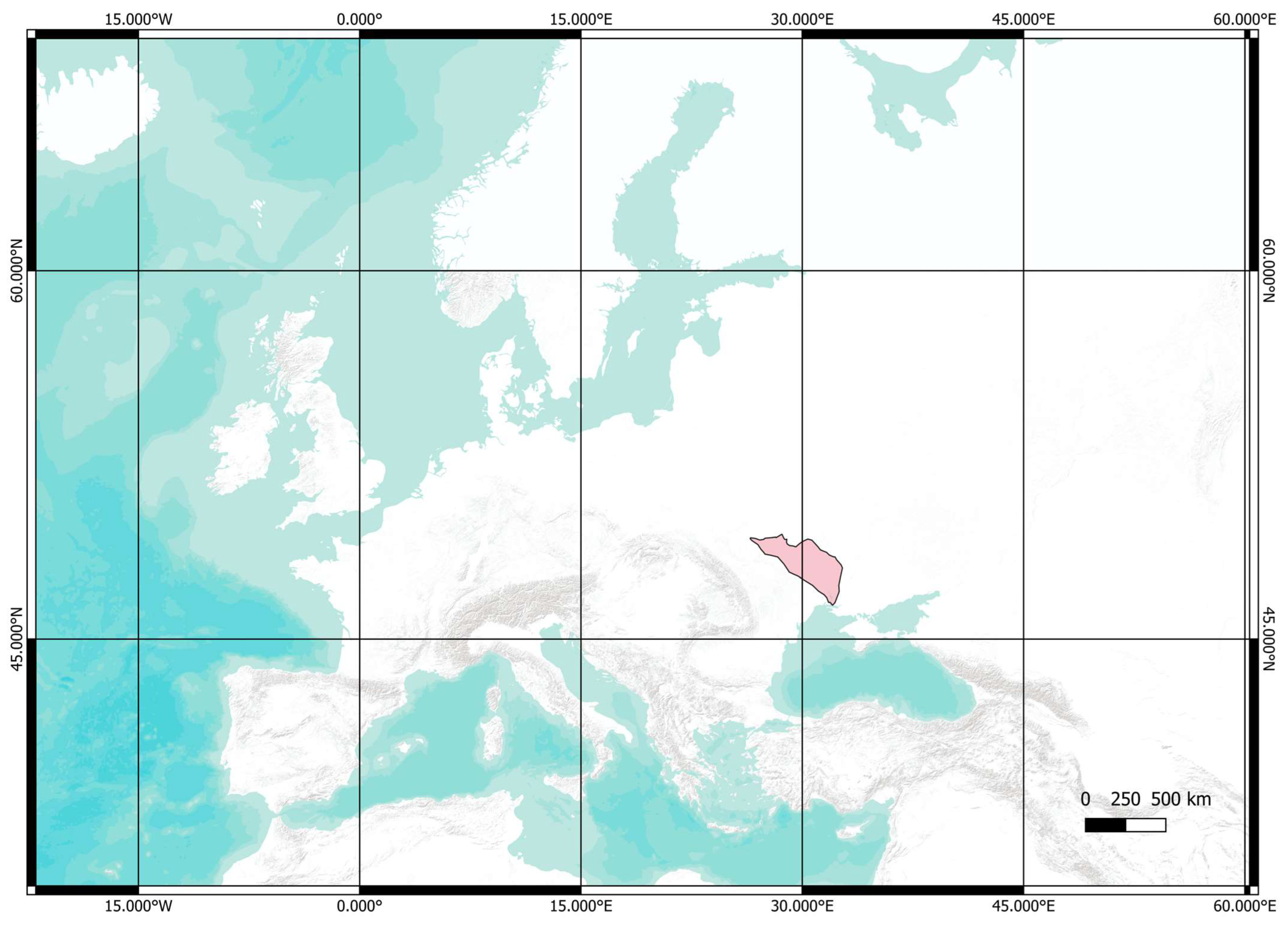
This research was carried out in the Southern Buh catchment (SBC, Figure 1): the region in southwest Ukraine that yielded sites of groups with the agriculture-based economy (Linear Pottery culture, LPC, and Trypillian culture, [19,20]) as well as sites of mobile groups with extractive economy equipped with pottery (Figure 2). Thus, their soil preferences can be directly compared here. Previously, the pedological analysis had been implemented in several hunter-gatherers’ sites in the SBC, with indecisive results: some sites contained traces of buried chernozems (Dobrianka 1 and 3, [21]), while the sediments from other sites (Gard and Lidyna Balka, [22]) were rather related to the floodplain pedogenesis. In the Trypillian settlement of Sabatynivka 1, the soil sections revealed a buried soil of chernozem type dating to the 5th mill. BC [23]. However, pedological research had been carried out in an opportunistic way, reflecting the ongoing archaeological projects. Thus, the authors propose a systematic program of pedological investigation in the SBC, encompassing both recently excavated and historic sites. In this paper, the results of pedological analysis on three settlements of the early farmers are compared with observations on two sites of the ceramic hunter-gatherers.
2. Region
The region of study (Figure 1) is situated along the Southern Buh River and its tributaries. The Southern Buh River is a natural connection between the hilly landscapes of the Podillia and Dnieper uplands on the one hand and the much flatter terrain of the steppe Black Sea lowland on the other hand. The region is characterized by the alteration of flooding watersheds with deep (up to 80–90 m), sometimes canyon-like valleys of rivers and gullies [24]. The slopes of gullies and rivers are often wooded. The river terraces are often not visible along the Southern Buh River course, and there is only a single cliff between a narrow strip of floodplain and a hilly loess plateau above [25]. The current vegetation patterns of the region are classified as a broadleaf forest, meadow-steppe landscape, and steppe when moving downstream [26].
The Southern Buh River is crossed in many places by rapids, mostly made of large granite blocks. They formed favorable fishing locations since prehistory [27].
The underlying Quaternary bedrock is represented mainly by loess [9]. The loess soils, preferred by early farmers of LPC in Central Europe [28], are so widespread here that it can be challenging to search for patches free of them. Thus, “loess islands” as an explanatory concept of LPC patchy character of settlement loses much of its heuristic value in Ukraine.
Nowadays, the soils of the SBC are mostly chernozems [25], Figure 2A. They are classified into three broad groups: (1) typical, deep (80–120 cm of the profile), with a small content of humus (4–6%), sometimes carbonized; (2) podzolized; (3) regraded. Podzolized and regraded chernozems are soils formed under deciduous vegetation and cultivated only relatively recently (since the 1950s). The region also has dark-grey and grey forest soils, mostly preserved under modern-day forests and nearby [29]. They cluster together with the two types of chernozem mentioned earlier (2 and 3).
The meadow soils (often meadow chernozems) were developed in the floodplains. This process occurred mainly in the vast stretches of wet lowland formed by the conjunction of the Southern Buh and its major tributaries (Savranka, Mohylianka). The sands and sandy soils are presented in the region in several pockets. The largest pockets are along the Savranka river and by the town of Haivoron [29].
Thus, the SBC exhibits a great variety of soils. Most soils are very fertile; however, they require somewhat different agricultural treatments to be productive. The modern dominance of chernozems is a relatively recent artifact of heavy cultivation [1].
In prehistory, humans settled in the region since the Paleolithic [30]. The Mesolithic sites are known in the region [27,31,32]. However, their chronology and cultural attribution are often uncertain. Later on, the region was occupied by groups of hunter-gatherers already equipped with pottery with the mostly extractive economy (called sub-Neolithic [33] or para-Neolithic [34]). The sub-Neolithic or para-Neolithic is defined by D.L. Haskevych as “cultures situated east [outside—D.K.] of the agricultural frontier”, where “influence of farming groups on their hunter-gatherer neighbours can be seen only in the sporadic exchange of prestigious goods, as well as in attempts to imitate the decorations and forms of pottery from the Criş Vinča, and Trypillia and some other Western cultures” [14]. The chronology of these groups is yet to be clarified. There were foragers’ sites with ceramic fragments by the second quarter of the sixth mill. BC [35] and some sites of this type existed in the early fifth mill. BC [36].
3. State of the Art
The empirical archaeological data on the cultural landscape in the region is sparse. The palaeobotanical analysis indicates that the alluvial deciduous forest composed of ash, oak, and elm existed on the Southern Buh riverbank in the SBC by the late seventh mill. BC and continued to exist well into LPC time, the last quarter of the sixth mill. BC [10]. At LPC Kamyane-Zavallia (Figure 2B: 12), Triticum cf. dicoccum, T. cf. monococcum, and cf. Hordeum remains demonstrated cereal use onsite. Among the weed macro remains identified at Kamyane-Zavallia, Chenopodium album type and Fallopia convolvulus can grow in cereal plots and field edges, thus showing that arable fields had replaced some parts of the forest by this time [10]. Thus, the agricultural landscape appeared in the SBC by 5250–5050 BC. The extensive data came from the Trypillian mega-site of Nebelivka (early fourth mill. BC) situated in the very north of the SBC [37,38,39]. Pollen analysis suggested a prolonged agricultural usage of territory around the mega-site, starting in the late fifth mill. BC [40].
No pollen cores covered the study period in the SBC. But, essential pollen cores 100 km to the west (Dovjok) and 130 km to the southeast (Troitske) contained data on the floral composition highly consistent with the paleobotanic observations [41,42].
The pedological analyses were carried out by Zh.M. Matviishyna and her students at several sites [43]. They revealed that buried soils, when preserved, belonged to several morphological types similar to those existing in the region today [21,22,44,45]. Shorter profiles of the late 5th mill BC soils made them similar to the “chernozems of southern type” developing under open grassland conditions. Thus, this observation probably reflects the existence of deforested patches in the landscape by 4350–4200 BC [23].
4. Sites and Methods
In the Southern Buh catchment, early farming settlement is represented by the sites of the Linear Pottery culture, early Trypillia, and Trypillia B1. The sections were studied on sites of these successive cultural aspects: Kamyane-Zavallia (LPC), Mohylna 3 (Trypillia A), and Kamyane-Zavallia 1 (Trypillia B1, Figure 2). The research was complemented by an analysis of two sites of ceramic hunter-gatherers (Melnychna Krucha and Mykolyna Broiaka, Figure 2: 6, 7). The sites were dated by radiocarbon method in the laboratory of Bern University (LARA) employing the MICADAS equipment [46,47]. Collagen extraction was performed according to Szidat et al. [47], which was extended with an additional ultrafiltration step. The results were calibrated with OxCal software [48], Version 4.4.4, based on the IntCal20 calibration curve [49].
Here and thereafter, we differentiate clearly between conventional radiocarbon ages (cited “BP”), calibrated 14C dates (cited “calBC”) and estimates interpolated from 14C dates, typological seriation and stratigraphies (cited “y. BC”).
The sections were studied by the micromorphological analysis in order to reconstruct the processes of pedogenesis. Thin sections were prepared in the geochemistry of isotopes laboratory of NASU by mechanical treatment without an application of HCl solution till the samples were 0.02–0.03 mm thin. The polarization microscope Min-8 aided the microscopic observation with a magnification of ×70. The details of the method employed for identifying soil structure were elaborated on in the paper [50]. The content of organic carbon was defined by the Tiurin method in modification of TSINAO [51]. Then, humus content was calculated by an application of coefficient 1.724. Granulometric analysis was performed using the Kachynskyi method [52]. Several cycles of soil development were defined for the region in question in line with the palaeoclimatological approach of M. Veklych [53]. The soil’s nomenclature corresponds to the WRB scheme [54]. At the same time, local terms [29] are used when we cite the results of published research for clarification (together with internationally recognized WRB terminology) and when the international terms are not enough to describe the situation under discussion.
5. Results
5.1. Early Farming Sites
5.1.1. Kamyane-Zavallia
Kamyane-Zavallia (48°10′51″ N; 30°0′25″ E) is the easternmost excavated site of LPC. It is situated on the right bank of the Southern Buh River in front of the town of Zavallia. Excavations covered an area of 130 sq. meters in 2013–2016 and over 400 sq. meters in 2019. Finds are numerous: over 2000 potsherds, some 5000 bone fragments, plant macro-remains (charcoal, very few seeds), pieces of burnt clay, and over 500 lithics. Two radiocarbon dates from pit 1 of Kamyane-Zavallia, fall within the last three centuries of the sixth millennium BC, more precisely between 5300–5032 and 5210–4952 cal BC (6200 ± 40 BP, Poz-67121 and 6130 ± 40 BP, Poz-67554, Table 1) [10,55]. Sections 1 and 2 were studied at the northern edge of excavation pit 1 (2014–2016). Section 1 revealed sparse archaeological finds (small, rounded potsherds); thus, it is situated in the site’s periphery. Section 2 cut a Neolithic pit (pit 1, which was dated by radiocarbon analysis, see above). Sections 1 and 2 were compared with the “natural” sections revealed in a cliff of the river-bank nearby as well as in the walls of stone quarry. Sections revealed similar sequences (Figure 3), which is characterized in Supplementary Table S1.
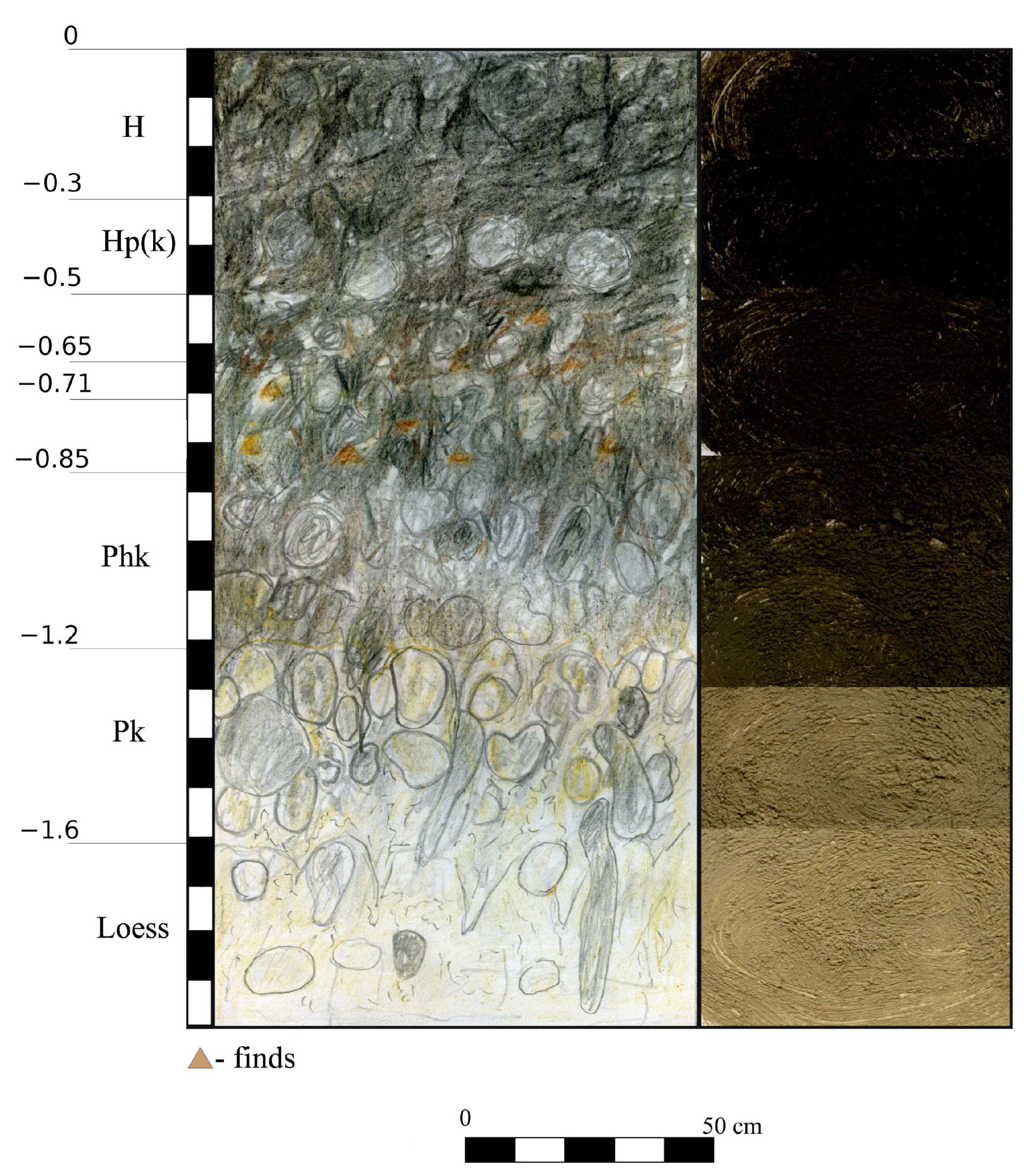
The modern soil observed in section 1 is characterized by a developed profile with well-defined horizons, intense humification, a clear granular–blocky structure, and carbonates in the lower horizons (Figure 3 and Figure 4). These traits enable us to define this soil as typical chernozem, accumulative, thick, made of light loam, formed on loess-like loams [9] of the first river terrace of the Southern Buh.
Section 2 revealed the same sequence but distorted by a pit of Neolithic (pit 1/9 of excavation trench 1). This pit and other pits in excavation trench 1 were traced from −0.55 m–0.6 m depth from the lower part of the horizon Hp(k). The modeling of artifact distribution in three dimensions confirms this observation [56]. The stone pavement of Linear Pottery culture was found by pit 1. The foundations of stones stood at the same depth [20]. In section 1, the sparse finds of Neolithic potsherds came from the same depth. Thus, the horizon of Neolithic activity corresponds to the lower part of the horizon Hp(k). So, the soil of LPC was reworked by further pedogenetic processes and the LPC remains were covered by the younger soil. However, it left a visible trace: humus shells of mineral grains were observed in thin sections of the sample coming from this layer. One of the authors (Zh.M.) reconstructs the soil of the Neolithic period as chernozem with three horizons H, Phk, Pk, 0.6–0.7 m thick. While the exact character of this soil is not yet apparent, it is evident that it contained a high content of humus, being arable, at least as the modern soil is. Moreover, considering that the analyzed sample comes from the horizon covering the layer of Neolithic activity (0.65–0.75 m), these observations can also relate to younger phases of the Neolithic, which are consistent with the results obtained in the nearby Trypillian settlement of Kamyane-Zavallia 1.
5.1.2. Mohylna 3
Mohylna 3 (48°14′32″ N; 30°4′45″ E) is a Trypillia A site situated on the eastern slope of a no-name tributary of the Mohylianka river (left tributary of the Southern Buh River). It is a large site with an area covering over 15 ha. Geomagnetic prospection covered seven hectares of the site’s area in 1993 [57]. The extensive collections of pottery, chipped stone artifacts, and figurines were gathered on the site’s surface and described on numerous occasions. N.B. Burdo noted that Mohylna 3 could hold a recent relative position in the typo-chronology of Early Trypillia [58]. The site’s small faunal collection mostly comprise fragmented cattle bones (definition of O.P. Siekerska, [34]). The numerous remains of cultivated plants were detected in imprints on potsherds and daub coming from the sites of Trypillia A [14], also situated near Mohylna 3. Thus, the site’s inhabitants practiced farming and herding.
Mohylna III is dated to 4616–4447 calBC (2σ) (BE-7649, 5712 ± 22 BP; BE-16908, 5699 ± 26 BP; BE-16909, 5679 ± 27 BP; Figure 2B: 14, Table 1). The latter two dates (BE-16908 and BE-16909) come from animal bones that were selected from the horizon 0.55–0.78 m deep in soil-section 1.
Soil-section 1 was situated on the very northern edge of the Trypillian site, where a deep gully created a cliff suitable for detailed examination. It was situated close to robbers’ illegal excavation pit that destroyed a fired-clay dwelling (ploschadka) of Trypillia A. Despite the absence of construction elements in the test trench, it is evident that most artifacts should be linked with the dwelling. The “natural” section (soil-section 2) was examined in the cliff of the upper terrace of the Mohylianka river, some 600 m upstream. Both sections yielded comparable sequences.
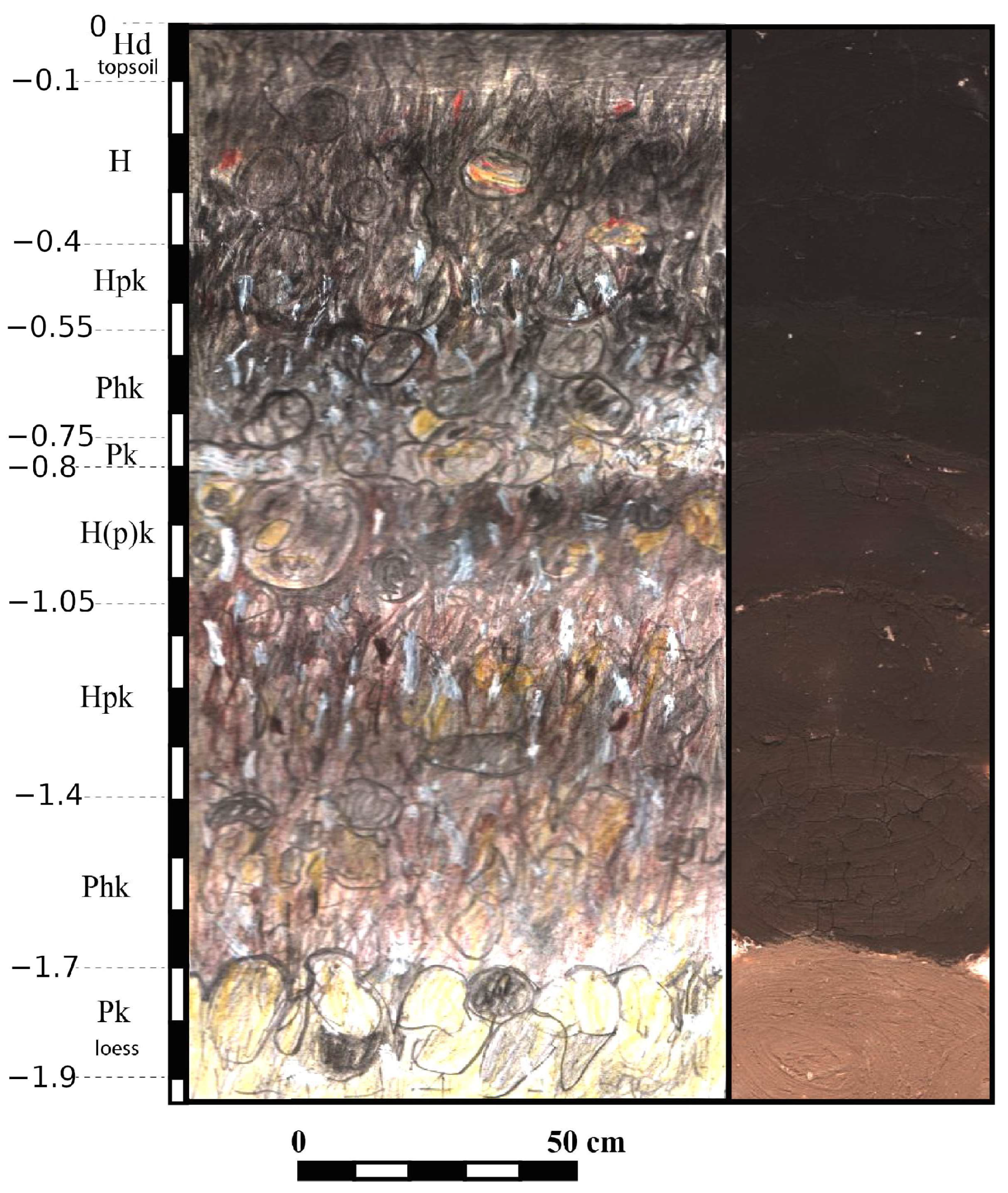
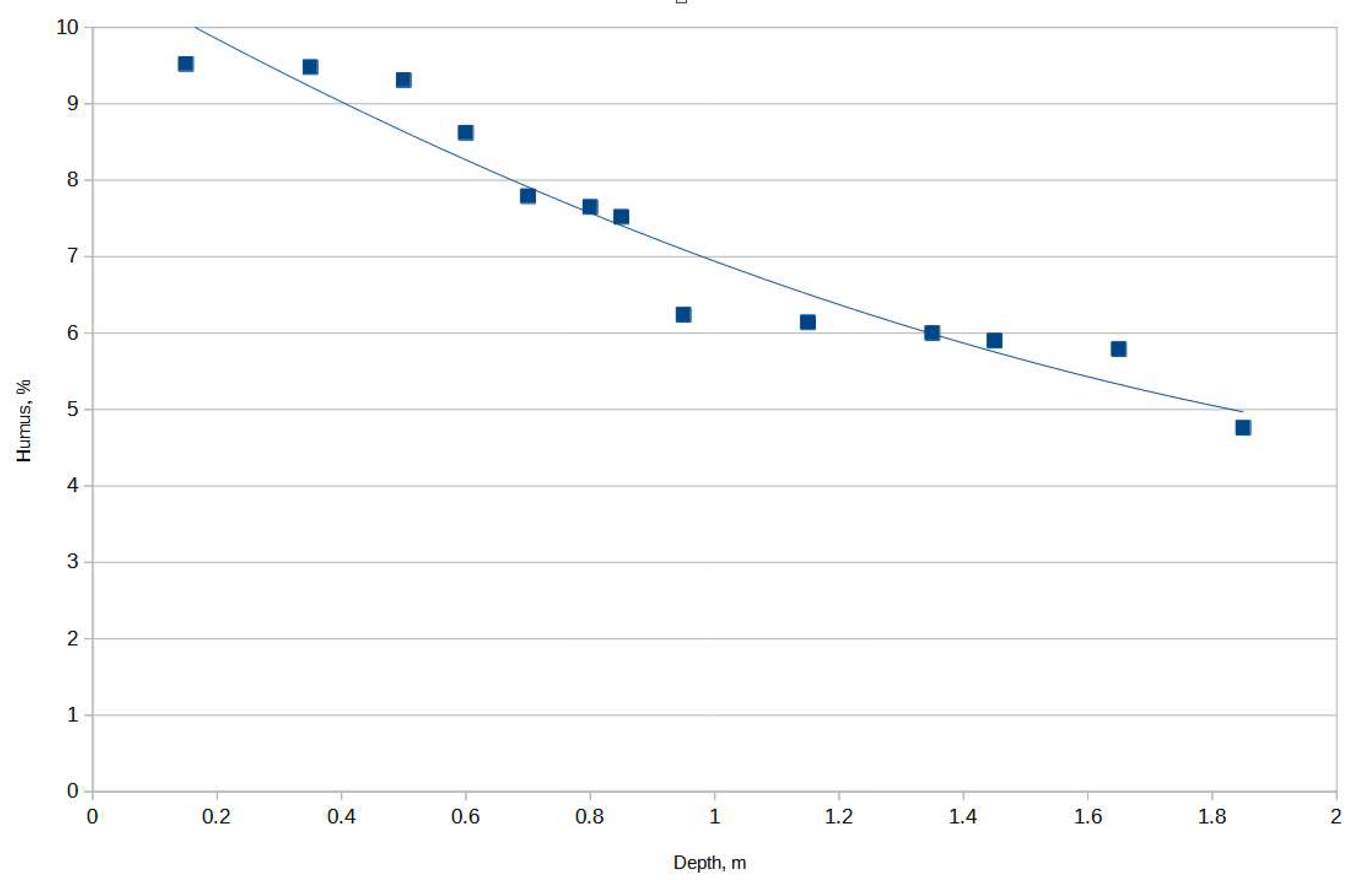
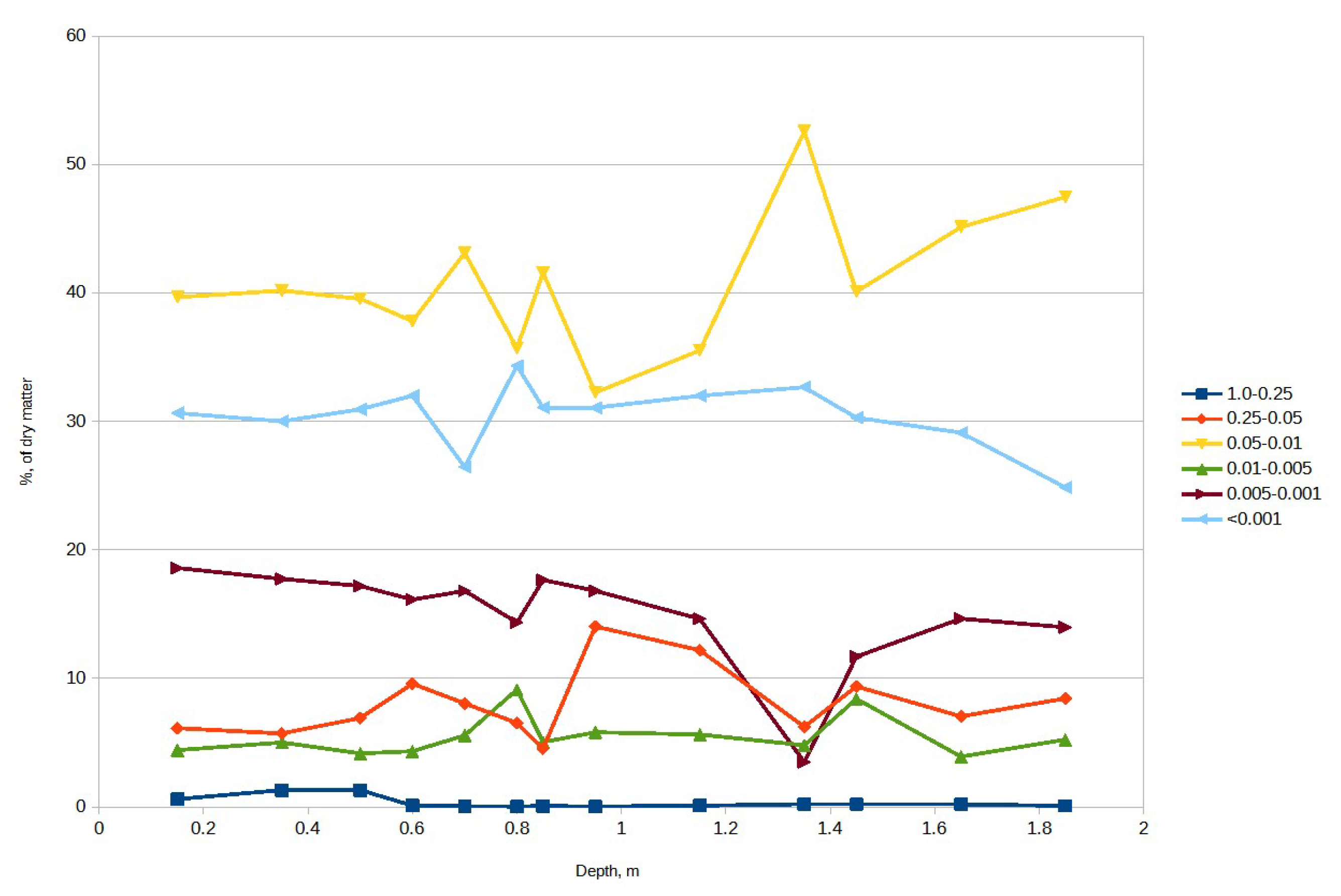
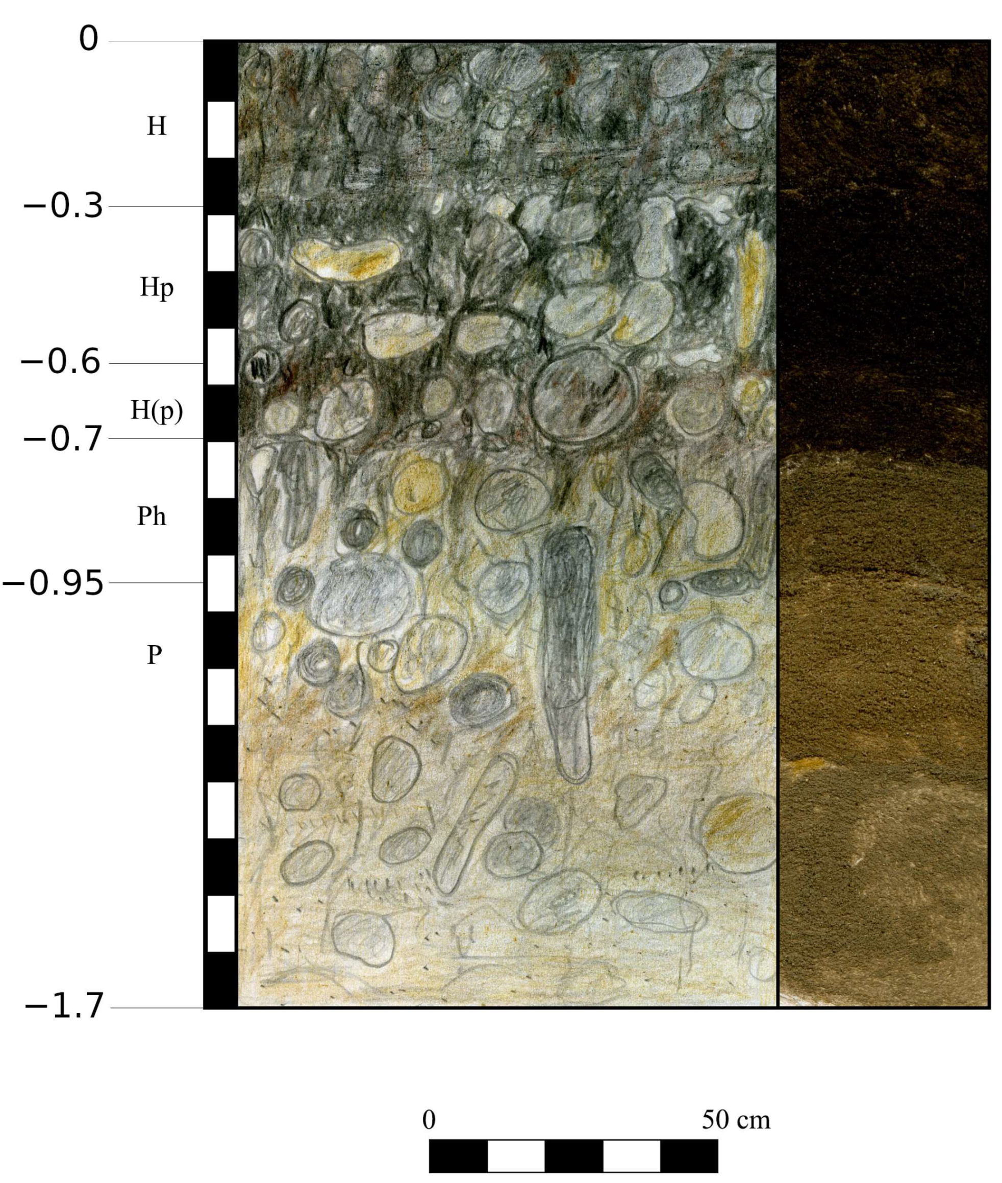
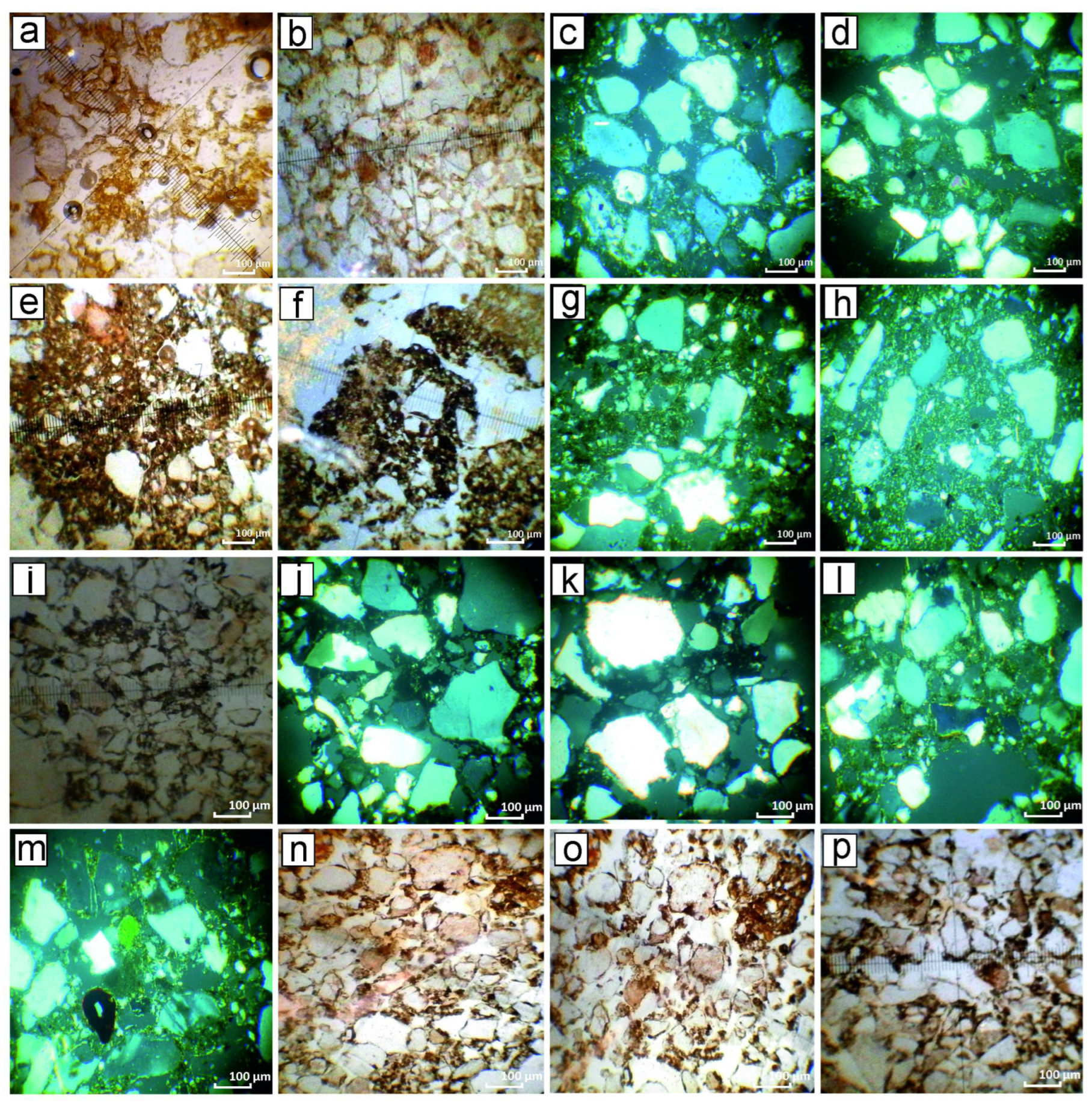
Under the arable layer (Figure 5), there was the upper soils (0.0–0.57 m), transitional horizon (0.75–0.80 m), the lower soil (0.8–1.7 m) with genetic horizons (H(p)k, Hpk, Phk, Pk), and the mother-rock (Pk)—white pale loess (1.7–2.0 m and below). The soils are made of terrace deposits of the Mohylna river valley. The soil profile is saturated by CaCO3 from the very surface to the bottom of the section in the shape of solved carbon and many micellar carbonates. Humus distribution (Figure 6) and granulometric composition (Figure 7) reflect several cycles of pedogenesis. The modern soil is gleyic chernozem, with micellar carbonates and a deep humic horizon. The finds of Early Trypillian artefacts were detected in the horizon 0.65–0.9 m deep. The same observation was made during an extensive archaeological test-trenching [34]. Thus, Trypillian activity happened on the surface of the lower soil. The process of soil formation can be reconstructed as follows (from bottom to top):
- Formation of pale white loess—cold periglacial steppe, likely of Buh phase.
- Early Holocene deposits altered by further pedogenesis.
- The lower soil, already well-developed by the foundation of the Early Trypillian site, probably of chernozem type with brownish coloring and structural peculiarities transitional to kastanozems formed under arid conditions.
- Erosional event—carbonate-rich light horizon at 0.75–0.8 m.
- At least two cycles of pedogenesis of modern-day gleyic chernozem.
5.1.3. Kamyane-Zavallia 1
Kamyane-Zavallia 1 (48°12′12″ N; 30°0′12″ E, Figure 2B: 11) is a site of the first stage of developed Trypillia (Trypillia B1). It is situated on a flat promontory of the first terrace of the right bank of the Southern Buh River. The site yielded ceramic groups similar to Trypillia A and small potsherds with painted decorations indicative of the Trypillia B1 (Cucuteni A3–4) stage. The lithic inventory comprise minor flat bifacial projectile points, a characteristic of developed Trypillia. The site belongs to the same local group with the nearby Trypillian sites excavated on the larger area: Sabatynivka 1 and Berezivska HES [59]. Both latter sites yielded abundant evidence of the agriculture: remains of domestic animals and cultivated plants [14,23]. The site of Kamyane-Zavallia 1 consisted of the habitation zone surrounded by two ditches [19]. Two animal bones from the inner ditch filling were selected for radiocarbon analysis. They yielded dates of 4337–4056 calBC, 2σ (Table 1) [59].
The soil-section was studied in the test-trench 3, opened outside the Trypillian ditch (Figure 8), thus in the archaeological site’s periphery. The “on-site” observations were controlled by examination of the modern cliff of the Southern Buh river in the vicinity of the site.
The soil profile with horizons H, Hp, Ph, P, and absence of carbonates are characteristic of mollic fluvisols formed on the alluvial silty loam (Figure 8 and Figure 9).
In this case, pedogenesis occurred in the high meadow plain on a sandy substrate. The most intense humus horizon is not the upper layer here, but the horizon from 0.3–0.7 m deep, especially the lower part of it (Figure 9, Supplementary Table S3). The available soil profile can be explained if the late Atlantic period mollic fluvisol was a substrate for the formation of modern soil and was only partially altered during this process. The artifacts of the Trypillian period were primarily attested in the humus (upper) horizon of the late Atlantic soil. The soil contained more humus than modern soil, so it was probably at least as arable as modern soil. The soil is relatively light for working because it was formed on the alluvial sands of the high meadow terrace. This sandy substrate is in clear contrast with the mostly loess substrate of the soils, which LPC farmers selected.
5.2. Sites of Hunter-Gatherers
5.2.1. Melnychna Krucha
Melnychna Krucha (48°8′49″ N; 30°13′1″ E, Figure 2B: 6) is a stratified site that yielded finds dating from the Mesolithic till the Iron Age. It is situated on the left northern bank of the Southern Buh River in the meadow plain. The site was discovered by S. I. Chub in 1930 and was excavated on several occasions from 1931 to 1949 [60]. The recent excavation project (2012–2018, jointly with prof. N. Kotova, Institute of Archaeology, Kyiv; and prof. W. Tinner, University of Bern) revealed a complex sequence with some stratigraphic units.
Stratigraphic unit (SU) 1a contained dispersed potsherds and bones of the late Bronze Age and Iron Age, while SU1b yielded potsherds of the Eneolithic period (late fifth–early fourth mill. BC, [61,62]).
SU2 consisted of a dense scatter of bones, debris of decortification of several concretions of yellow-wax flint layer of lithics, and eight potsherds. This habitation belonged to local pottery-bearing groups, with subsistence still primarily based on fishing, hunting, and gathering. The recovered bones mostly belonged to red deer and wild boar (definition of O.P. Siekerska [35]). The archaeobotanical analysis combined with flotation failed to recover remains of cultivated plants coming from this unit [10]. Three very consistent radiocarbon dates date it to 5966–5787 cal BC (BE-7641: 6986 ± 24 BP; BE-7638: 6985 ± 22 BP; BE-7637: 6980 ± 24 BP, Table 1), while a single determination is younger than the rest—5736–5651 cal BC (BE-7640: 6812 ± 24 BP, [35]).
SU3 contained lithic artifacts, fragmented animal bones, turtle shell plates, avian bones, fish vertebrae, and bones of small mammals. The lithic inventory is microlithic with some microcores, end-scrapers on flakes, backed bladelets, and an isosceles trapeze [32]. Four radiocarbon dates come from SU3, dating to the last half of the seventh mill. BC, namely 6461–6100 cal BC (Poz-67496: 7520 ± 50 BP, BE-7639: 7436 ± 23 BP, BE-10308: 7404 ± 23 BP, Poz-67497: 7380 ± 40 BP, Table 1, [35]).
The lowermost layer (SU4) contained fragmented auroch bones and lithic implements. The chipped stone inventory included:
- Conical cores for fine bladelets and microblades;
- Multiple burins on blade’s spalls;
- Points with partial abrupt retouch forming a distal acute tip and a notch on the opposite end by a bulb [32].
Three dates come from this unit. They encompass 7520–7315 cal BC, (BE-7636: 8368 ± 23 BP, BE-10309: 8344 ± 23 BP, BE-7635: 8311 ± 24 BP, Table 1, [35]).
Thus, the Melnychna Krucha is a “long” sequence, covering the eighth–fifth/fourth mill. BC.
Paleopedological analysis was carried out on the eastern wall of square 6 of the excavation pit of Melnychna Krucha and on the nearby cliff of the Southern Buh Riverbank outside the archaeological site. Both sections (“archaeological” and “natural”) yielded the same sequence. The general depth of sediments is over 4 m. The rapid accumulation rates led to the repeated burying of the ancient soils, avoiding their complete alteration in the younger pedogenesis. There are three consecutive soils in the sequence (Figure 10).
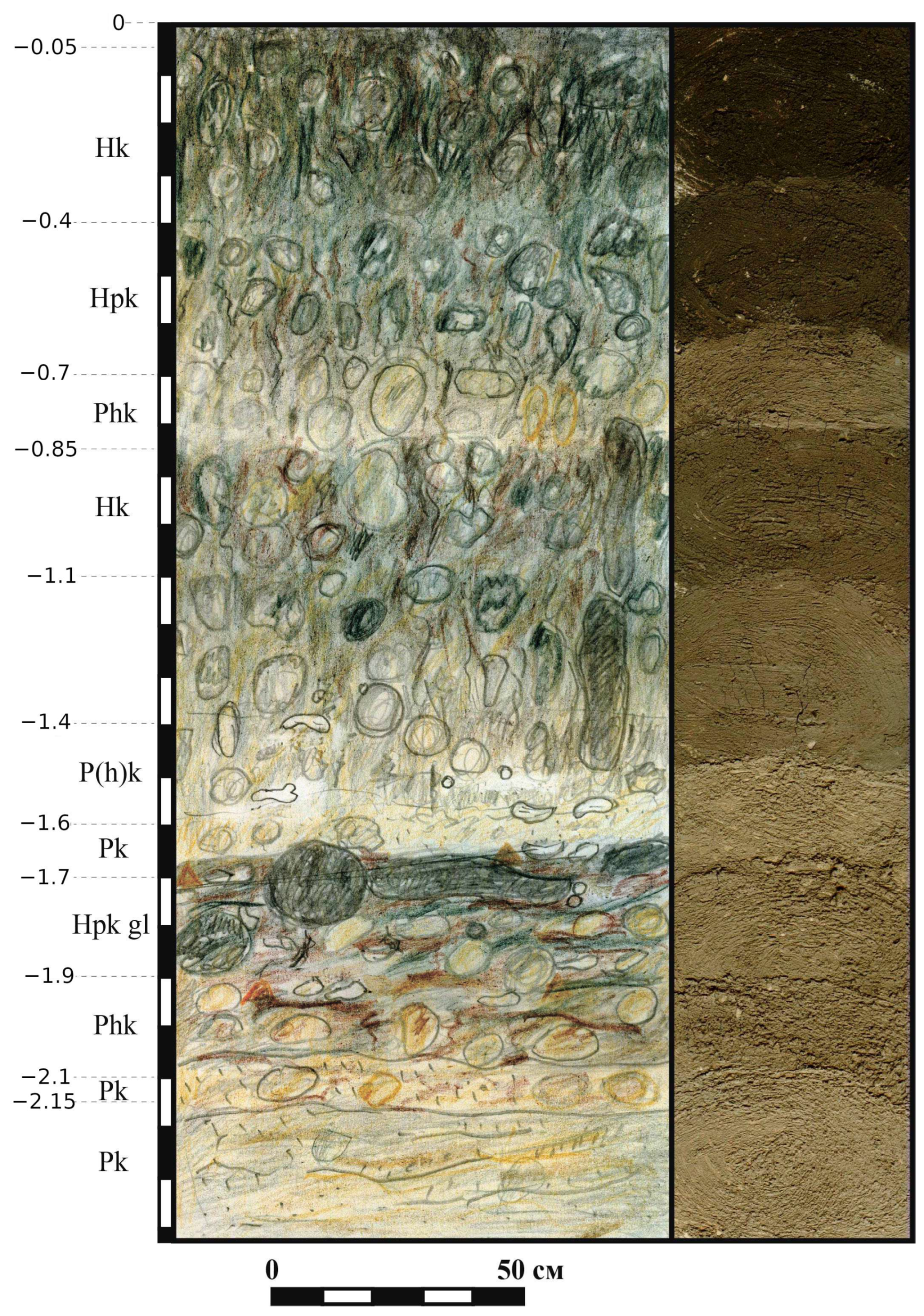
Sections revealed a complex soil sequence up to 4 m deep. There are three consecutive pedogenesis cycles, reflected in respective soils with developed profiles. The upper soil (0.0–0.85 m) comprises four genetic horizons (Supplementary Table S4, Figure 11, Figure 12 and Figure 13) and is clearly separated from the underlying sediments by a well-visible lighter horizon of light dusty loam. The middle soil (0.85–1.7 m) is a light loam with upper horizons rich in humus formed on the lower horizons of light yellow color and loess-like texture. In the excavation pits the horizons corresponding to the middle soil contained artefacts of Eneolithic (the late 5th–early 4th mill. BC, definition of N.S. Kotova [21]). The lower soil (1.7–1.9 m) is a light sandy loam with humus-rich upper horizon—Hpk (gl)—1.7–1.9 m—humus horizon with interchanging layers of grey and brownish-grey stripes 5–7 cm wide. The stripped pattern indicates periodic flooding. In the vicinity of Melnychna Krucha, accumulative processes shaped the formation of a high meadow plain from alluvial material with partial redeposition of the latter under the subaerial conditions. It resulted in the development of a soil sequence thicker than the soils of similar age in the higher river terraces and watershed plateaus. The active deposition enabled us to define three soils separated by illuvial carbonate horizons.
The upper and middle soils were formed under subaerial conditions, while the lower soil developed in a very moist environment, which was probably periodically flooded. The margin between the middle and lower soils is clear and likely represents an erosion event. It also corresponds to an interruption of soil formation processes, when organic matter was largely reduced, and instead, yellow dust and sand formed the lowermost horizon of the middle soil. The upper and middle soils resemble calcaric fluvisols formed under steppe vegetation on light clay loam of alluvial origin. In contrast, the lower soil is gleyic podzol from a taxonomic point of view and was formed under hydromorphic conditions.
The SU2 (ceramic hunter-gatherers) remains are associated with the lowermost part of the middle soil (horizons Pk and P(h)k), SU3 (the late Mesolithic) with the upper horizon of the lower soil (horizon Hpk (gl)), while SU4 (the middle Mesolithic) was uncovered in the lower horizons of the lower soil (Phkgl and Pkhorizons). Thus, both stratigraphic units of Mesolithic age were developed under wet, periodically watered conditions, along the river beach. The ceramic hunter-gatherers of SU2 settled on the hydromorphic soil barely suitable for any meaningful agricultural activity.
5.2.2. Mykolyna Broiaka
Mykolyna Broiaka (48°09′50″ N 30°53′02″ E, Figure 2B: 7) is a site of ceramic hunter-gatherers. It was found by local inhabitants and excavated by P. Kharlampovych in 1932 [65] and by V. Danilenko and M. Shamglii in 1955 [27]. Both excavations revealed a complex stratigraphy: two layers of ceramic hunter-gatherers material culture at a certain distance from the riverbank in 1955 [27] or a probable Eneolithic horizon above the shell-midden with hunter-gatherers potsherds and lithics in 1932 [66]. Two radiocarbon dates come from this site: from the lower layer—5719–5625 cal BC (Be-18269, 6762 ± 27 BP), and from the upper stratigraphic unit—4678–4493 cal BC (BE-18270, 5731 ± 26 BP, Table 1), probably corresponding to the shell-midden in excavations of 1932.
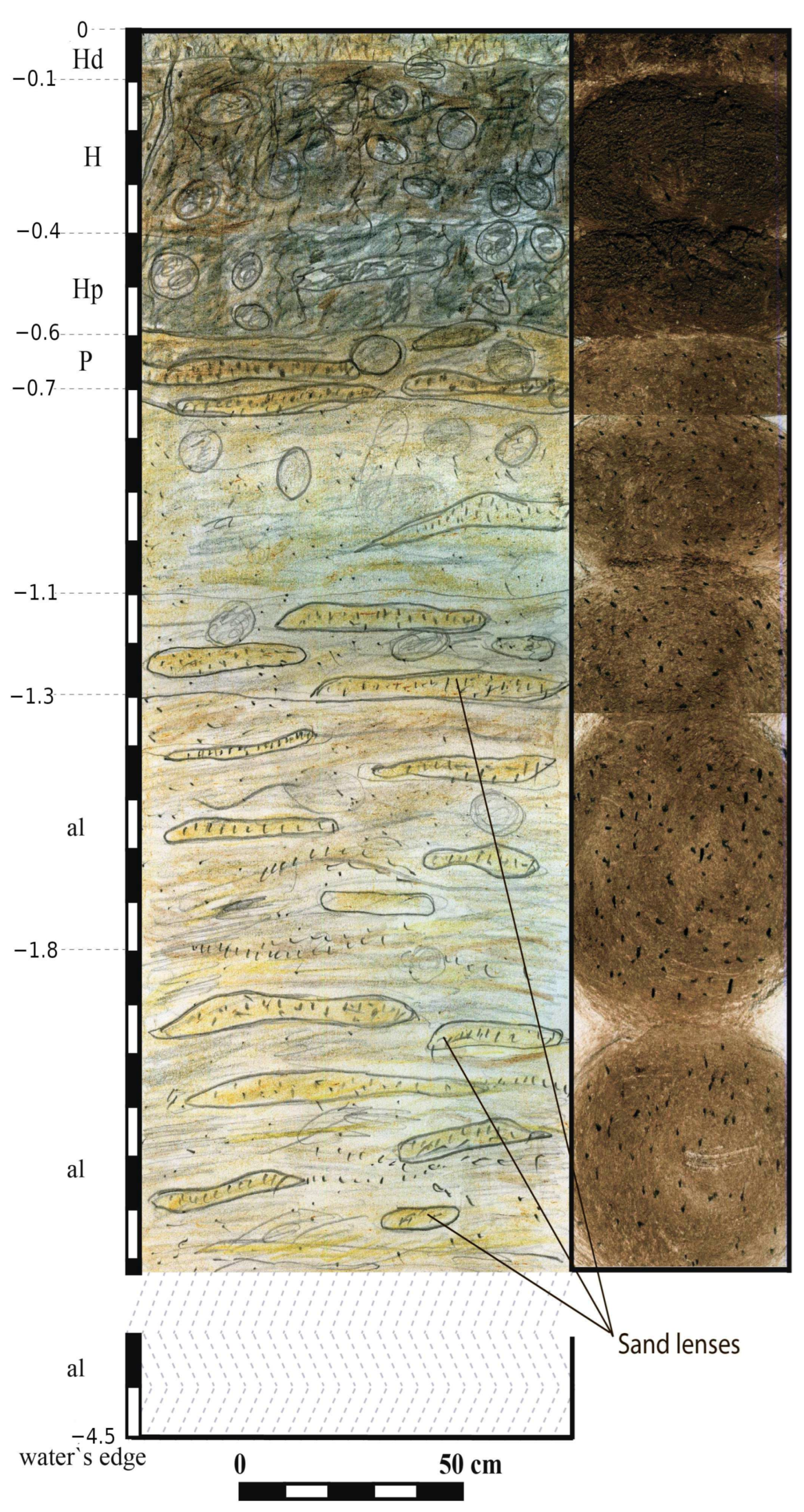
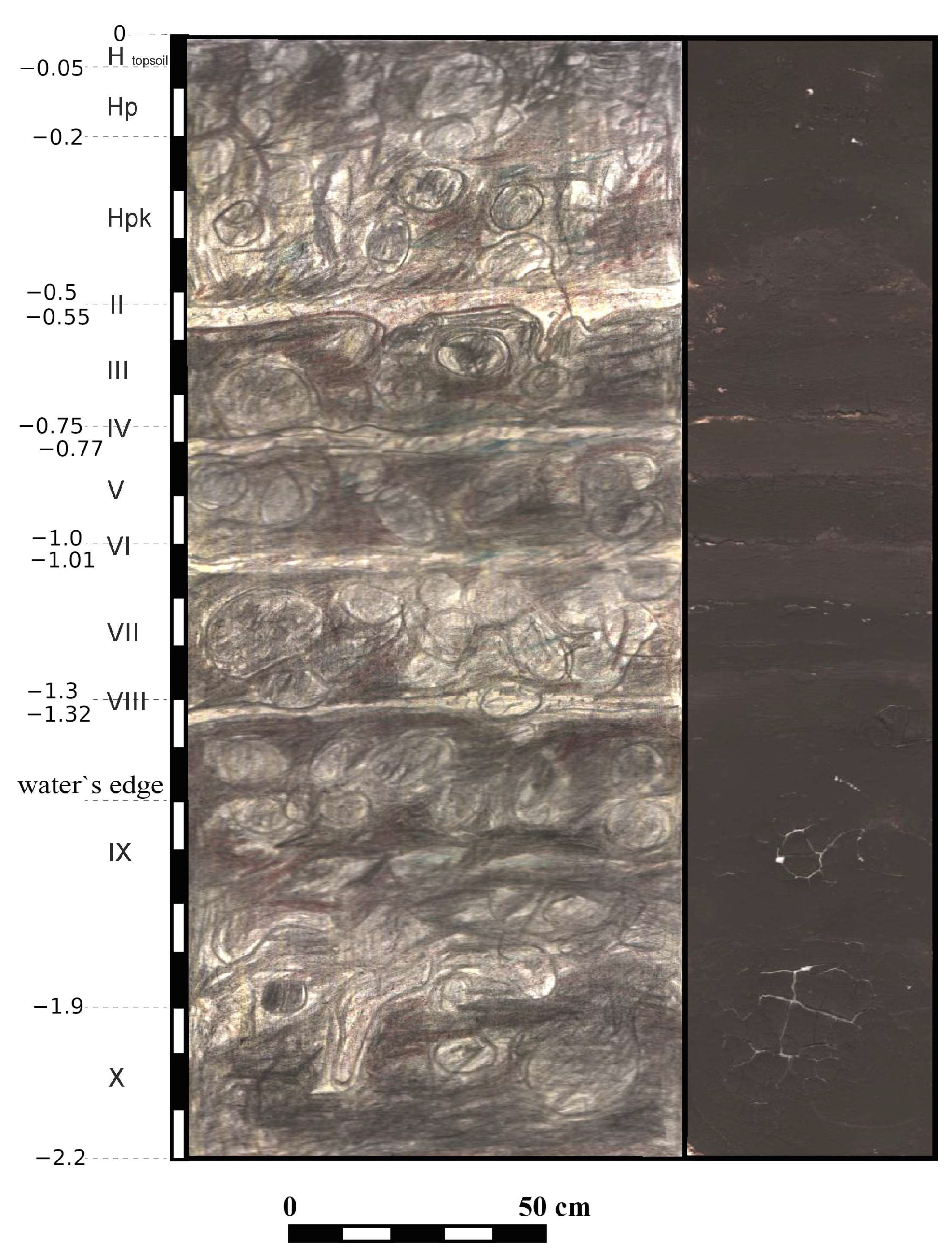
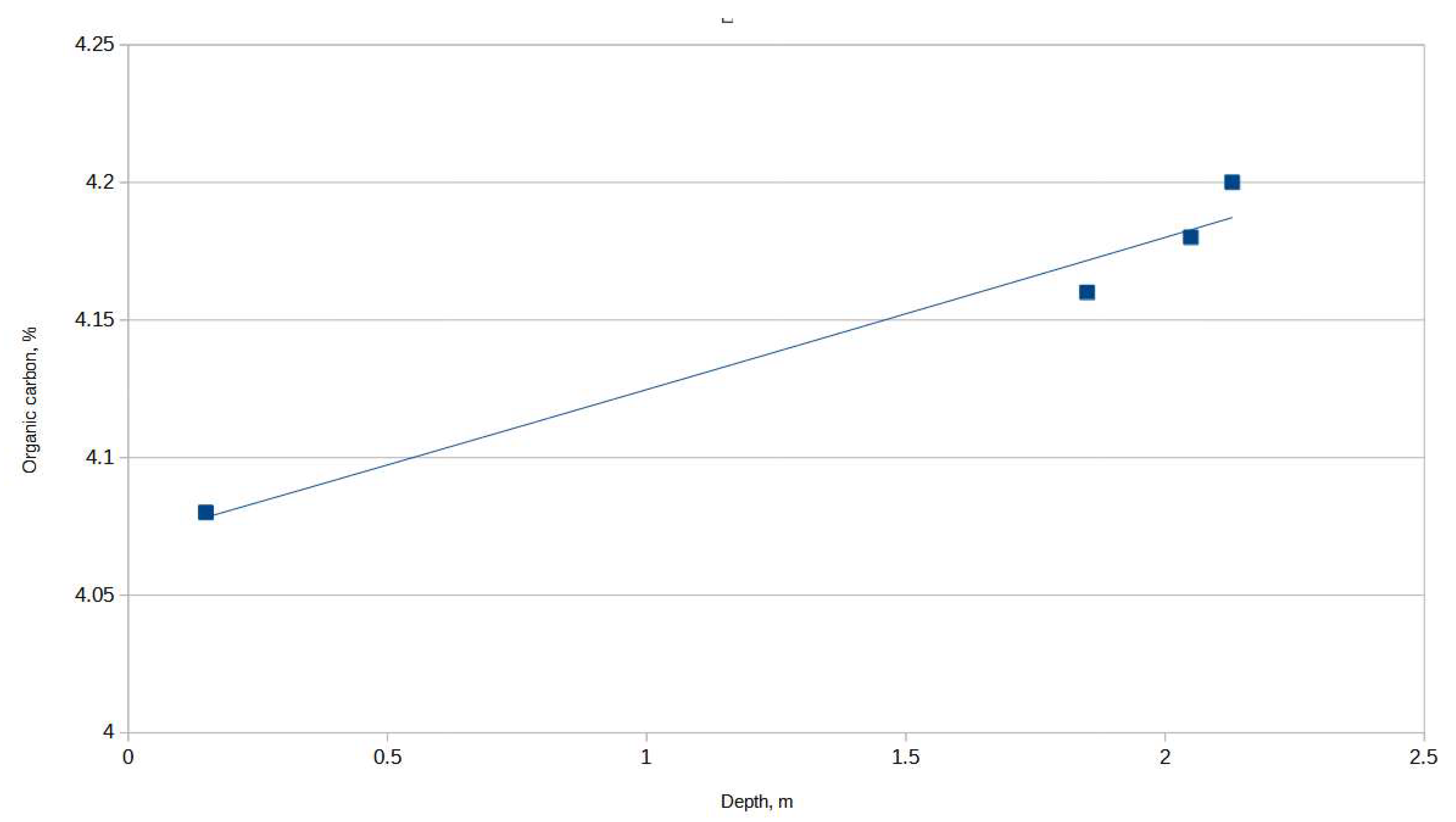
There were two studied soil sections: section 1 by the site of an older excavation of 1932 and section 2 in a natural context some 200 m downstream. Both sections cut a cliff (0.7 m high) of a meadow terrace rising above the lower floodplain about 20 m wide. Section 1 revealed a modern soil (0.0–0.5 m) of gleyic mollic fluvisol type. Underneath, there was a sequence of dark loose horizons of clay loam (20–50 cm thick) separated by white-yellow-grey dense horizons 5–10 cm thick, indicating events of prolonged flooding (Figure 14). In general, the sequence was formed in hydromorphic regime. The section cut the shell-midden at a depth of 1.8–1.9 m, which corresponds well with the depth reported in the 1932 excavation. Thus, we can establish the stratigraphic position of the horizon related to activity of ceramic hunter-gatherers in the section 1. It is embedded between humic (Figure 15) sediments formed under hydromorphic regime, under conditions of periodical flooding. The latter is clearly reflected in periodic changes in granulometry of sediments (Figure 16).
Section 2, which was situated outside the archaeological site, confirmed this observation yielding a sequence of soils formed under conditions of periodic flooding, probably corresponding to the upper six horizons observed in section 1 (See descriptions of sections, Supplementary Table S5). Thus, the site of ceramic hunter-gatherers was situated on the beach of the riverbank and was flooded periodically. They settled on the marshy alluvial sediments barely suitable for arable agriculture.
6. Discussion
Neolithic farmers had certain patterns of soil exploitation, which were well established in central and southern Europe [28,67,68]. However, the geographical correspondence between Neolithic sites and the modern soil distribution can be misleading, because soils underwent a prolonged evolution, which could have altered their character in some regions. Particular sedimentary conditions exist at many Neolithic sites in the south of eastern Europe. The archaeological remains are covered by a thick (sometimes over 1 m) layer of later Holocene deposits. On the one hand, this situation makes any large-scale excavation of these sites a complex enterprise [69]. On the other hand, it opens the possibility to study the soil sequences looking for trends of pedogenesis during the Holocene [70].
The earliest agriculture in the Southern Buh catchment is attested by finds of archaeobotanical remains in the LPC settlement of Kamyane-Zavallia [10]. The pedological analysis of the soil sections at this site revealed traces of a fertile, humic, short-profiled soil formed on the loess. The modern soil at the site is fertile chernozem, morphologically light clay loam. Micromorphological analysis indicates the feeble presence of buried soil at a depth of the expected walking surface (−50–−85 cm). It is dark grey or blackish, loose with evident blocky–granular, light clay loam. Under microscope, it is well visible that every sand grain is surrounded by a humic–clayish cover, thus indicating fertility comparable with the modern local soil. This arable soil existed during LPC time or slightly post-dated the LPC habitation.
In the Mohylna 3 site, the Early Trypillian farmers exploited a fertile soil of chernozem type transitional to kastanozems by its structural characteristics, indicating arid conditions when it was formed. The buried soil is rich in humus and organic carbon.
The Trypillia B1 (4400–4200 BC) farmers built their settlements by mollic fluvisol formed on sandy alluvial deposits (Kamyane-Zavallia 1, this work) or by chernozem formed on alluvial silts (Sabatynivka 1, [23]). The buried soils contained humus horizons 25–30 cm thick, thus being fertile. The groups of later stages of Trypillia from the nearby portions of the Dnieper River basin also exploited chernozem soils (Likareve, Trypillia B2; [44,45,71]). In the site of Sabatynivka 1, the development of chernozem was stopped by erosional event of the late fifth mill. BC [23]. Similar chronology maybe applicable also to lower soils of Mohylna 3 and Kamyane-Zavallia 1.
Contrary to the above-described pattern, the ceramic hunter-gatherers settled on soils of other types. Their remains were found in the erosional event layer above silty alluvial deposits at Melnychna Krucha and inside marshy–fluvial layered sediments at Mykolyna Broiaka. Although the modern soils on both sites are arable and exploited for agriculture, it seems that the soils available in sixth–fifth mill. BC were not suitable for agriculture, and humans settled on the riverbanks pursuing other economic needs, probably fishing, hunting, and gathering.
This observation can be checked by a reference to four other sites of local hunter-gatherers studied by pedological approach. The sites of Dobrianka 1 and 3 [18,72] were investigated in the valley of Velyka Vys river (a second-order tributary of Southern Buh). They seem to contradict the observation under discussion, because Zh.M. Matviishyna reconstructed chernozems as the buried soils corresponding to “Neolithic” period layers at these sites [21]. However, we should consider the complexity of the taphonomic situation on both sites [73]. The dating efforts yielded dates of the early Holocene [74], late seventh mill. BC [18], as well as some Bronze Age dates [75] coming from the same depth (Table 1). So, the chernozems could be formed later with the altered materials of the “Neolithic” cultural layer.
The site of Gard yielded a sequence about 3 m deep. This site’s lower layer is a para-Neolithic layer, rich in lithic implements and pottery with some imports of the late Criş culture (5600–5400 BC) [76]. It is a H(p) horizon of mollic fluvisol. This soil formed under wet conditions on alluvial sandy loam. The upper layer of Gard contained the “Late Neolithic” layer, where hunter-gatherers’ ceramics and Trypillia A potsherds were found in large quantities [16]. This soil is formed in subaerial conditions and is suitable for some limited agriculture. In the Lidyna Balka site, the soil corresponding to the para-Neolithic horizon is gleyic mollic fluvisol, also formed under quite wet conditions [22].
The local hunter-gatherer groups of the Southern Buh River valley were treated as Neolithic when their culture was discovered [27,77]. R. Tringham suggested that they were fishers, hunters, and gatherers acquainted with agriculture and herding [78]. Later on, this model was elaborated by D. Telegin [36,79,80] and N. Kotova [15,81,82]. M. Zvelebil and M. Lillie suggested they were hunters in the availability phase [83]. Recently, a growing amount of data sheds doubt on the acquaintance of the indigenous groups of the Southern Buh River with an agriculture-based economy. The imprints of domestic plant seeds and pericarps in shards of para-Neolithic pottery were reexamined, and no compelling evidence of domesticates was found [14,84]. The archeozoological collections contained either no domestic animal bones or were mixed with later materials, thus casting doubt on the evidence of herding [85]. The flotation efforts on the sites of ceramic hunter-gatherers failed to produce the remains of domestic plants, despite good preservation of archaeobotanical remains [10,86]. In the catchment of the Dnieper River, isotope studies on the human bones demonstrated a late (fifth mill. BC) arrival of herding in the region [87]. The settlement pattern studies have demonstrated that local hunter-gatherers tended to settle by the river rapids in meadow plains and on river islands, where agriculture is impossible even today. At the same time, early farming sites cluster on the first terraces by small streams and gullies in places suitable for agriculture [88,89,90]. Thus, nowadays, it seems that, by the arrival of LPC farmers, indigenous groups practiced an exclusively extractive economy in southern Ukraine [11].
Our results on buried soils from hunter-gatherers’ sites reinforce this observation. In four of seven reported cases, para-Neolithic remains were found to be associated with soils formed under periodical flooding, barely suitable for agriculture. A single case (upper horizon of Gard) yielded soil suitable for limited agricultural activities such as gardening [22]. Moreover, two cases when chernozems were attested with artifacts of ceramic hunter-gatherers can be effectively doubted on taphonomic grounds. It seems we cannot be sure about the chronology of these soils. In contrast, every early farming site under study yielded fertile soil: three cases of chernozems of different types and a single case of mollic fluvisol, rich in humus with a developed profile.
The issue of hunter-gatherers/early farmers interaction is particularly vivid in the south of eastern Europe. Here, two subsistence systems coexisted for millennia in six–fourth mill. BC. Sometimes, in a single microregion, there are sites of hunter-gatherers, and those of early farmers separated just by a few kilometers of distance. This is the case in the Southern Buh valley, where LPC sites of Kamyane-Zavallia and Hnyla Skelia stood less than 4 km from hunter-gatherers sites of Zavallia and Zhakchyk, the Trypillia A settlement of Haivoron stood near the hunter-gatherers’ site Haivoron-Polizhok, and Trypillia B1 sites neighbored the hunter-gatherers’ sites of Melnychna Krucha and Savran. In the 1980s, the issue of possible coexistence between hunter-gatherers and agrarian communities was taken into account in relation to the first reliable absolute dates for the period in question [36,80]. In recent years this topic definitely became part of the broader discussion of the Neolithization of eastern Europe [33,63,90,91,92]. Significant new information also playing a crucial role in these discussions comes from sites recently discovered particularly in the Southern Buh catchment [20,38]. These discoveries, combined with the application of fine-tuned radiocarbon dating and geoarchaeological studies, are now gradually widening the gap between both societies in question.
The observation of the soil preferences enables us to argue that the early farmers (LPC and Trypillia) and indigenous hunter-gatherers equipped with pottery had different spatial organization; the former looked for arable fields while the latter for good fishing places. These differences could be evidence of different mobility cycles within the same space, utilized in different economic ways. Their economic needs intersected only partially, and thus, there was limited competition for spatially distributed resources. Indeed, this model is a simplification. The economic cycles of both cultures were quite complex and could not have depended only on the exploitation of single locations. However, the tendency is evident nowadays: the hunter-gatherers’ sites are often found on periodically flooded soils, while early farmers often relied on chernozems.
7. Conclusions
In this work, we studied the geographical correspondence between sites of several Neolithic cultures and the past soil distribution. In order to carry out the comparison, we compiled the radiocarbon database (Table 1) and conducted paleopedological research on three sites of early farmers and two sites of indigenous groups with an extractive economy. The results indicate a variable pattern of soil exploitation.
The soil development has been attested since, at least, the beginning of the fifth mill. BC, followed by the development of chernozem soils, which were interrupted by an erosional episode at the end of fifth millennium cal BC. Paleopedological analysis has shown that past soils can significantly differ from modern-day soils at the same site. Sometimes, these discrepancies are crucial for our interpretation of an economic basis of past societies (Melnychna Krucha being the most evident example).
The available data show that the soils of early farmers are arable as are the present-day ones. The early farmers were able to exploit relatively heavy soils to cultivate wheat and barley as early as 5250–5050 cal BC. Early farmers’ sites stood on chernozem soils (three cases), or on chernozem-type soil (a single case) and on a mollic fluvisol (a single case). There is no evidence to suggest that the chernozem soils were ploughed rather than worked by sticks and hoes, nor did this paper aim to provide such an evidence. In contrast, the sites of ceramic hunter-gatherers were often located on soils that formed under wet conditions along seasonally-flooded riverbanks, which were almost unsuitable for agricultural practices, namely on silty alluvial deposits (three cases), or on marshy–fluvial layered sediments (a single case) or on a mollic fluvisol (a single case), while two cases were dismissed as dubious from post-depositional perspective.
The database (twelve sites) is yet limited and the further research can change the observed pattern. At the moment, we can suppose that early farmers and ceramic hunter-gatherers had drastically different preferences in soil selection. Early farming sites were often situated on arable soils, while hunter-gatherers paid little attention to fertility of an underlying soil when choosing a location for a site. Surely, sites could have been located at a certain distance from paleofields. However, combining different lines of inquiry (archaeobotanical and paleozoological data, observations on sites’ topography), the presented data contradict the hypothetical model of limited agriculture practiced by the ceramic hunter-gatherers in the Southern Buh river basin.
Supplementary Materials
The following supporting information can be downloaded at: https://www.mdpi.com/article/10.3390/land12020388/s1, Supplementary Table S1: Soil section 1 of the Kamyane-Zavallia site, Supplementary Table S2: Soil section 1 of the Mohylna 3 site, Supplementary Table S3: Soil section 1 of the Kamyane-Zavallia 1 site, Supplementary Table S4: Soil section 1–2 of the Melnychna Krucha site, Supplementary Table S5: Soil section 1 of the Mykolyna Broiaka site.
Author Contributions
Conceptualization, D.K. and Z.M.; methodology, Z.M.; software, D.K.; field-work, D.K. and Z.M.; sections’ description, Z.M.; micromorphology, Z.M.; radiocarbon dates’ interpretation, D.K.; archaeological contexts, D.K.; writing—original draft preparation, D.K.; writing—review and editing, Z.M.; funding acquisition, D.K. All authors have read and agreed to the published version of the manuscript.
Funding
This project was supported by the European Union’s Horizon 2020 research and innovation program under the Marie Skłodowska-Curie grant agreement No. 891737.
Data Availability Statement
All the data produced during the project are included into the paper.
Acknowledgments
The radiocarbon dates were made available for us thanks to cooperation with W. Tinner and S. Szidat in the framework of the SNF SCOPES grant, Project IZ73Z0_152732. The authors are grateful to Lisa Holitsyna for language editing.
Conflicts of Interest
The authors declare no conflict of interest.
References
- Pozniak, S. Chernozems of Ukraine: Past, Prezent and Future Perspectives. Soil Sci. Annu. 2019, 70, 193–197. [Google Scholar] [CrossRef]
- Saile, T. On the Bandkeramik to the East of the Vistula River: At the Limits of the Possible. Quat. Int. 2020, 560–561, 208–227. [Google Scholar] [CrossRef]
- Dreibrodt, S.; Hofmann, R.; Dal Corso, M.; Bork, H.-R.; Duttmann, R.; Martini, S.; Saggau, P.; Schwark, L.; Shatilo, L.; Videiko, M.; et al. Earthworms, Darwin and Prehistoric Agriculture-Chernozem Genesis Reconsidered. Geoderma 2022, 409, 115607. [Google Scholar] [CrossRef]
- Schmidt, M.W.I.; Skjemstad, J.O.; Gehrt, E.; Kögel-Knabner, I. Charred Organic Carbon in German Chernozemic Soils. Eur. J. Soil Sci. 1999, 50, 351–365. [Google Scholar] [CrossRef]
- Gerlach, R.; Baumewerd-Schmidt, H.; van den Borg, K.; Eckmeier, E.; Schmidt, M.W.I. Prehistoric Alteration of Soil in the Lower Rhine Basin, Northwest Germany—Archaeological, 14C and Geochemical Evidence. Geoderma 2006, 136, 38–50. [Google Scholar] [CrossRef] [Green Version]
- Gerlach, R.; Fischer, P.; Eckmeier, E.; Hilgers, A. Buried Dark Soil Horizons and Archaeological Features in the Neolithic Settlement Region of the Lower Rhine Area, NW Germany: Formation, Geochemistry and Chronostratigraphy. Quat. Int. 2012, 265, 191–204. [Google Scholar] [CrossRef]
- Lorz, C.; Saile, T. Anthropogenic Pedogenesis of Chernozems in Germany?—A Critical Review. Quat. Int. 2011, 243, 273–279. [Google Scholar] [CrossRef]
- Von Suchodoletz, H.; Tinapp, C.; Lauer, T.; Glaser, B.; Stäuble, H.; Kühn, P.; Zielhofer, C. Distribution of Chernozems and Phaeozems in Central Germany during the Neolithic Period. Quat. Int. 2019, 511, 166–184. [Google Scholar] [CrossRef]
- Matviishyna, Z.M.; Doroshkevych, S.P. Micromorphological Peculiarities of the Pleistocene Soils in the Middle Pobuzhzhya (Ukraine) and Their Significance for Paleogeographic Reconstructions. J. Geol. Geogr. Geoecology 2019, 28, 327–347. [Google Scholar] [CrossRef]
- Salavert, A.; Gouriveau, E.; Messager, E.; Lebreton, V.; Kiosak, D. Multi-Proxy Archaeobotanical Analysis from Mesolithic and Early Neolithic Sites in South-West Ukraine. Environ. Archaeol. 2020, 26, 349–362. [Google Scholar] [CrossRef]
- Motuzaite-Matuzeviciute, G.; Telizhenko, S. The First Farmers of Ukraine: An Archaeobotanical Investigation and AMS Dating of Wheat Grains from the Ratniv-2 Site. Archaeol. Litu. 2016, 17, 100–111. [Google Scholar] [CrossRef] [Green Version]
- Potekhina, I.; Telegin, D. On the Dating of the Ukrainian Mesolithic-Neolithic Transition. Curr. Anthropol. 1995, 36, 823–826. [Google Scholar] [CrossRef]
- Telegin, D.Y.; Lillie, M.; Potekhina, I.D.; Kovaliukh, M.M. Settlement and Economy in Neolithic Ukraine: A New Chronology. Antiquity 2003, 77, 456–470. [Google Scholar] [CrossRef]
- Endo, E.; Nasu, H.; Haskevych, D.; Gershkovych, Y.; Videiko, M.; Yanevich, O. Re-Identification of Plant Impressions on Prehistoric Pottery from Ukraine. J. Archaeol. Sci. Rep. 2022, 42, 103364. [Google Scholar] [CrossRef]
- Kotova, N.S. Neolithization in Ukraine; John and Erica Hedges Ltd.: Oxford, UK, 2003. [Google Scholar]
- Tovkailo, M. Neolithic of Steppe Buh Region [Neolit Stepovogo Pobuzhzhia]; Shliakh: Kyiv, Ukraine, 2005; p. 160. [Google Scholar]
- Okhrimenko, G.V. Kamyana Doba Na Terytorii Pivnichno-Zahidnoji Ukrajiny (XII-III Mill.BC) [Stone Age on the Territory of North-Western Ukraine (XII-III Mill. BC)]; VAT “Volyns’ka Oblasna Drukarnia”: Lutsk, Ukraine, 2009; p. 520. [Google Scholar]
- Zaliznyak, L.; Tovkailo, M.T.; Man’ko, V.O.; Sorokun, A.A. Stojanky Bilia Hutora Dobryanka t’a Problema Neolityzatsii Bugo-Dnistrovs’kogo Mezhyrichia [Sites in the Vicinity of the Dobryanka Hamlet and Issue of Bug-Dniester Interfluvial Neolithization] (In Ukrainian). Kamiana Doba Ukr. [Kaм’янa дoбa Укpaїни] 2013, 15, 194–257. [Google Scholar]
- Saile, T.; Posselt, M.; Dębiec, M.; Kiosak, D.; Tkachuk, T. Zwei Magnetometerprospektionen Auf Ukrainischen Fundstellen Des Cucuteni-Tripolje-Komplexes an Dnjestr Und Südlichem Bug. Archäologisches Korresp. 2016, 46, 465–477. [Google Scholar]
- Kiosak, D. Kamyane-Zavallia, the Eastermost Linear Pottery Culture Settlement Ever Excavated. Spraw. Archeol. 2017, 69, 253–270. [Google Scholar] [CrossRef] [Green Version]
- Matviishyna, Z.M.; Parkhomenko, O.G. Hrunty Neolitychnykh Stoianok Bilia Sela Dobrianka Na Cherkaschyni Iak Indykator Davnih Paleolandshaftiv [Soils of Neolithic Sites by Vill. Dobrianka as an Indicator of Past Landscapes]. Kamiana Doba Ukr. 2007, 10, 181–190. [Google Scholar]
- Matviishyna, Z.M.; Fomenko, V.M.; Tovkailo, M.T.; Doroshkevych, S.P. Paedological Studies of Multilayered Sites Gard and Lidyna Balka in Southern Buh Steppe Region. Kamiana Doba Ukr. 2015, 16, 190–203. [Google Scholar]
- Lobanova, M.A.; Matviishyna, Z.M.; Kiosak, D.V. The Issue of the Stratigraphy of the Site Sabatinovka i and the Enviromental Settings of the Southern Bug Region in the Eneolithic—Late Bronze Age. Strat. Plus 2021, 2021, 31–52. [Google Scholar] [CrossRef]
- Marynych, O.M. (Ed.) Geografichna Enzyklopedia Ukrainy [Geographic Encyclopedia of Ukraine]; T. 1 A-ZH; Ukrainska Radianska Enzyklopedia Imeni M.P. Bazhana: Kyiv, Ukraine, 1990. [Google Scholar]
- Doroshkevych, S.P. Pryroda Seredniogo Pobuzhzhia u Pleistotseni Za Danymy Vyvchennia Vykopnykh Hruntiv [Nature of Middle Buh Region in Pleistocene after the Data of Research on Buried Soils]; Naukova Dumka: Kyiv, Ukraine, 2018. [Google Scholar]
- Loza, Y. Istorychnyi Atlas Ukrainy. Naidavnishe Mynule. Rus (Kyivska Derzhava, Halytsko-Volynska Derzhava); Mapa: Kyiv, Ukraine, 2010. [Google Scholar]
- Danilenko, V.N. Neolit Ukrainy: Glavy Drevnejshej Istorii Jugo-Vostochnoj Evropy [Neolithic Ukraine: Issues of Ancient History of South-East Europe]; Naukova Dumka: Kyiv, Ukraine, 1969; p. 258. [Google Scholar]
- Petrasch, J. Settlements, Migration and the Break of Tradition: The Settlement Patterns of the Earliest Bandkeramik and the LBK and the Formation of a Neolithic Lifestyle in Western Central Europe. Quat. Int. 2020, 560–561, 248–258. [Google Scholar] [CrossRef]
- Krupskoi, N.K.; Polupan, N.I. (Eds.) Atlas Pochv Ukrainskoi SSR [Atlas of Soils of the Ukrainian SSR]; Urozhai: Kyiv, Ukraine, 1979. [Google Scholar]
- Stepanchuk, V.; Ryzhov, S.; Rekovets, L.; Matviishina, Z. The Lower Palaeolithic of Ukraine: Current Evidence. Quat. Int. 2010, 223–224, 131–142. [Google Scholar] [CrossRef]
- Gaskevych, D.L. Problemy Radiovugletsevogo Datuvannia Bugo-Dnistrovskoji Neolitychnoji Kul’tury [Issues of the Radiocarbon Dating of Bug-Dniester Neolithic Culture]. Arheologija 2014, 4, 3–17. (In Ukrainian) [Google Scholar]
- Kiosak, D. The Mesolithic of the North Pontic Region and the Transition to the Neolithic. Eurasian Prehistory 2019, 15, 279–292. [Google Scholar]
- Haskevych, D.; Endo, E.; Kunikita, D.; Yanevich, O. New AMS Dates from the Sub-Neolithic Sites in the Southern Buh Area (Ukraine) and Problems in the Buh-Dnister Culture Chronology. Doc. Praehist. 2019, 46, 216–245. [Google Scholar] [CrossRef]
- Kiosak, D. Lithic Industries of Early Farmers between Carpathians and Dnieper: Social Context and Organization of Production; Odesa “I.I. Mechnikov” National University: Odesa, Ukraine, 2019. [Google Scholar]
- Kiosak, D.; Kotova, N.; Tinner, W.; Szidat, S.; Nielsen, E.; Brugger, S.; de Capitani, A.; Gobet, E.; Makhortykh, S. The Last Hunter-Gatherers and Early Farmers of the Middle Southern Buh River Valley (Central Ukraine) in VIII-V Mill. BC. Radiocarbon 2021. [Google Scholar] [CrossRef]
- Telegin, D.J. Neolithic Cultures of the Ukraine and Adjacent Areas and Their Chronology. J. World Prehistory 1987, 1, 307–331. [Google Scholar] [CrossRef]
- Gaydarska, B. (Ed.) Early Urbanism in Europe: The Trypillia Megasites of the Ukrainian Forest-Steppe; De Gruyter Open Poland: Warsaw, Poland; Berlin, Germany, 2020; p. 576. [Google Scholar]
- Gaydarska, B.; Nebbia, M.; Chapman, J.; Caswell, E.; Arbeiter, S.; Ovchinnikov, E.; Gaskevych, D.; Lazăr, C.; Ignat, T.; Boyce, A.; et al. The Finds. In Early Urbanism in Europe: The Trypillia Megasites of the Ukrainian Forest-Steppe; De Gruyter: Warsaw, Poland; Berlin, Germany, 2020; pp. 265–414. [Google Scholar]
- Chapman, J. The Standard Model, the Maximalists and the Minimalists: New Interpretations of Trypillia Mega-Sites. J. World Prehistory 2017, 30, 221–237. [Google Scholar] [CrossRef] [Green Version]
- Albert, B.; Innes, J.; Krementskiy, K.; Millard, A.R.; Gaydarska, B.; Nebbia, M.; Chapman, J. What Was the Ecological Impact of a Trypillia Megasite Occupation? Multi-Proxy Palaeo-Environmental Investigations at Nebelivka, Ukraine. Veg. Hist. Archaeobotany 2020, 29, 15–34. [Google Scholar] [CrossRef] [Green Version]
- Bezusko, L.G. Novi Palinologichni Haraketerystyky Vidkladiv Holocenu Bolota Troitske (Mykolaivska Oblast, Ukraina) [New Pollen Characteristics of Holocene Deposits from Troitske Bog (Mykolaiv Region, Ukraine)]. Ukr. Bot. Zhurnal 2010, 67, 560–576. [Google Scholar]
- Kremenetski, C.V. Holocene Vegetation and Climate History of Southwestern Ukraine. Rev. Palaeobot. Palynol. 1995, 85, 289–301. [Google Scholar] [CrossRef]
- Kushnir, A.; Leiberiuk, O. Database of Paleosoil Research of the Holocene within the Plains of Ukraine on the Basis of GIS Technology. Ukr. Geogr. J. 2022, 2022, 47–52. [Google Scholar] [CrossRef]
- Matviishyna, Z.M.; Doroshkevych, S.P.; Kushnir, A. Reconstruction of Trypillian Time Landscapes Using Paleopedological Studies. Visnyk Lviv Univ. Ser. Geogr. 2014, 48, 107–116. [Google Scholar] [CrossRef]
- Matviishyna, Z.M.; Doroshkevych, S.P. Reconstruction of Natural Atlantic Holocene Stage Condisionts Based on the Paleosoil Research of Trypillia Settlement. Ukr. Geogr. J. 2016, 2, 19–25. [Google Scholar] [CrossRef] [Green Version]
- Szidat, S.; Salazar, G.A.; Vogel, E.; Battaglia, M.; Wacker, L.; Synal, H.-A.; Türler, A. 14C Analysis and Sample Preparation at the New Bern Laboratory for the Analysis of Radiocarbon with AMS (LARA). Radiocarbon 2014, 56, 561–566. [Google Scholar] [CrossRef]
- Szidat, S.; Vogel, E.; Gubler, R.; Lösch, S. Radiocarbon Dating of Bones at the LARA Laboratory in Bern, Switzerland. Radiocarbon 2017, 59, 831–842. [Google Scholar] [CrossRef]
- Bronk Ramsey, C.; Lee, S. Recent and Planned Development of the Program OxCal. Radiocarbon 2013, 55, 720–730. [Google Scholar] [CrossRef]
- Reimer, P.J.; Austin, W.E.N.; Bard, E.; Bayliss, A.; Blackwell, P.G.; Bronk Ramsey, C.; Butzin, M.; Cheng, H.; Edwards, R.L.; Friedrich, M.; et al. The IntCal20 Northern Hemisphere Radiocarbon Age Calibration Curve (0–55 Cal KBP). Radiocarbon 2020, 62, 725–757. [Google Scholar] [CrossRef]
- Matviishyna, Z.M.; Kushnir, A.S. Geoarchaeological Approach in Paleosoil Research of Archaeological Sites. Ukr. Geogr. J. 2018, 4, 10–15. [Google Scholar] [CrossRef] [Green Version]
- Mebius, L.J. A Rapid Method for the Determination of Organic Carbon in Soil. Anal. Chim. Acta 1960, 22, 120–124. [Google Scholar] [CrossRef]
- Rząsa, S.; Owczarzak, W. Methods for the Granulometric Analysis of Soil for Science and Practice. Pol. J. Soil Sci. 2013, 46, 1–50. [Google Scholar]
- Veklych, M.F. Problemy Paleoklimatologii [Issues of Paleoclimatology]; Naukova Dumka: Kyiv, Ukraine, 1987; p. 190. [Google Scholar]
- IUSS Working Group. WRB World Reference Base for Soil Resources, 4th ed.; IUSS: Vienna, Austria, 2022. [Google Scholar]
- Kiosak, D.; Salavert, A. Revisiting the Chronology of Two Neolithic Sites in Eastern Europe: New Radiocarbon Dates from Melnychna Krucha and Kamyane-Zavallia (Southern Buh Region, Ukraine). Rev. Archeol. 2018, XIV, 116–131. [Google Scholar]
- Kiosak, D.; Radchenko, S. 3-D Pit: Linear Pottery Culture Long Pit Reconstructed through Point-Cloud Analysis. Digit. Appl. Archaeol. Cult. Herit. 2021, 21, e00188. [Google Scholar] [CrossRef]
- Peresunchak, O.S.; Burdo, N. Kolektsia Plastyky Iz Ranniotrypil’s’kogo Poselennia Mohyl’na III [Collection of Plastics from Early Trypillian Site of Mohyl’na III]. In Kul’turnyi Kompleks Cucuteni-Trypillia ta Yogo Susidy. Zbirka Naukovykh Prats’ Pamiati Volodymyra Krutsa; Diachenko, O., Menotti, F., Ryzhov, S., Buniatian, K., Kadrow, S., Eds.; Astroliabia: Lviv, Ukraine, 2015; pp. 357–366. [Google Scholar]
- Burdo, N.B. Ranniotrypils’ki Pamiatky Mizh Selamy Mohylna Ta Zhakchyk Na Kirovogradschyni [Early TrypillieanTrypillian Sites between Villages Mohyl’na and Zhakchik in the Kirovograd Region]. Archaeom. Ta Ohor. Istoryko-kul’turnoji Spadschyny 1997, 1, 67–71. [Google Scholar]
- Kiosak, D.; Lobanova, M. On the Chronology of the Sabatynivka Group of the Cucuteni-Trypillia Cultural Complex (Central Ukraine). Spraw. Archeol. 2021, 73, 25–46. [Google Scholar] [CrossRef]
- Gaskevych, D.L. Melnychna Krucha—Bagatosharova Pamiatka Pervisnoji Doby Na Pivdni Lisostepovogo Pobuzhzhia [Melnychna Krucha—Multilayered Site of Prehistoric Time in the South of Forest-Steppe Southern Bug Region]. Arheol. I Davnia Istor. Ukr. 2012, 8, 13–22. [Google Scholar]
- Reingruber, A.; Rassamakin, Y.Y. Zwischen Donau Und Kuban: Das Nordpontische Steppengebiet Im 5. Jt. v. Chr. In Der Schwarzmeer Raum vom Neolithikum bis in die Früheisenzeit (6000-600 v. Chr.): Kulturelle Interferenzen in der Zirkumpontischen Zone und Kontakte mit ihren Nachbargebieten; Nikolov, V., Schier, W., Eds.; Leidorf: Rahden-Westf, Germany, 2016; pp. 273–311. [Google Scholar]
- Rassamakin, Y.Y. Mohylnyky Ihren (Ohrin) 8 Ta Oleksandria Doby Eneolitu: Problemy Datuvannia Ta Kulturnoi Nalezhnosti [Cemeteries of Ihren (Ohrin) 8 and Olexandriia of Eneolithic Epoch; the Issue of Dating and Cultural Attribution]. Arkheologija 2017, 4, 26–48. [Google Scholar] [CrossRef]
- Kiosak, D.; Kotova, N.; Radchenko, S.; de Capitani, A.; Gobet, E.; Makhortykh, S.; Nielsen, E.; Szidat, S.; Tinner, W.; Tuboltsev, O.; et al. Chipped Stone Assemblage of the Layer B of the Kamyana Mohyla 1 Site (South-Eastern Ukraine) and the Issue of Kukrek in the North Meotic Steppe Region. Open Archaeol. 2022, 8, 85–113. [Google Scholar] [CrossRef]
- Telegin, D.J. Pro Nomenklaturnyh Spysok Kremianykh Vyrobiv Doby Mezolitu-Neolitu [On the Nomenclature List of Flint Implements of Mesolithic-Neolithic]. Arkheologija 1976, 8, 21–45. [Google Scholar]
- Kharlampovych, P.V. Neolitychna Statsiia “Mykolyna Broiaka” Na Richtsi Chornyi Tashlyk [Neolithic Site ‘Mykolyna Broiaka’ on the Chornyi Tashlyk River]. Kamiana Doba Ukr. [Кам’яна дoба України] 1932, 7, 228–234. [Google Scholar]
- Polischuk, L.Y.; Kiosak, D. Нoві Матеріали Дo Істoрії Археoлoгічнoгo Вивчення Південнoгo Пoбужжя Novi Materialy Do Istorii Arkheologichnogo Vyvchennia Pivdennogo Pobuzhzhia [New Materials on the History of Archaeological Research in the Southern Buh Region]. In Starodavne Prychornomoria; Nemchenko, I.V., Ed.; ONU “I.I. Mechnikov”: Odesa, Ukraine, 2018; pp. 436–445. [Google Scholar]
- Zimmermann, A.; Wendt, K.P.; Frank, T.; Hilpert, J. Landscape Archaeology in Central Europe. Proc. Prehist. Soc. 2009, 75, 1–53. [Google Scholar] [CrossRef]
- Hofmann, D.; Banffy, E.; Gronenborn, D.; Whittle, A.; Zimmermann, A. Als Die Menschen Sesshaft Wurden: Die Jungsteinzeit in Süd- Und Mitteldeutschland. In Spuren des Menschen: 800 000 Jahre Geschichte in Europa; Bánffy, E., Hofmann, K.P., von Rummel, P., Eds.; WBG Theiss in Wissenschaftliche Buchgesellschaft (WBG): Darmstadt, Germany, 2019; pp. 110–133. [Google Scholar]
- Saile, T.; Dębiec, M.; Posselt, M.; Ţerna, S.; Kiosak, D. Zur Bandkeramik Zwischen Pruth Und Südlichem Bug. Praehist. Z. 2016, 91, 1–15. [Google Scholar] [CrossRef]
- Dmytruk, Y.; Matviyishyna, Z.; Kushnir, A. Evolution of Chernozem in the Complex Section at Storozheve, Ukraine. In Soil as World Heritage; Dent, D., Ed.; Springer: Dordrecht, The Netherlands, 2014; pp. 91–100. ISBN 978-94-007-6187-2. [Google Scholar]
- Ryzhov, S.; Shumova, V. Likareve Settlement and Its Place among Trypils’ka Culture Monuments of Middle Stage. Magisterium 2011, 45, 25–29. [Google Scholar]
- Zaliznyak, L.L.; Man’ko, V.O. Stoyanky Bilia s. Dobryanka Na r. Tikych t’a Deiaki Problemy Neolityzatsii Seredniogo Podniprovia [Sites in the Vicinity of Dobryanka Village on the River Tikych and Some Issues of Neolithization of Middle Dnieper Region]. Kamiana Doba Ukr. 2005, 4, 137–168. (In Ukrainian) [Google Scholar]
- Kotova, N.S. Drevnejshaja Keramika Ukrainy [The Most Ancient Pottery in Ukraine]; Maidan: Kyiv/Kharkiv, Ukraine, 2015. [Google Scholar]
- Lillie, M.; Budd, C.; Potekhina, I.D.; Hedges, R.E.M. The Radiocarbon Reservoir Effect: New Evidence from the Cemeteries of the Middle and Lower Dnieper Basin, Ukraine. J. Archaeol. Sci. 2009, 36, 256–264. [Google Scholar] [CrossRef]
- Biagi, P.; Zaliznyak, L.; Kozlowski, S. Old Problems and New Perspectives for the Radiocarbon Chronology of the Ukrainian Mesolithic? In Proceedings of the UNESCO-IUGS-IGCP-INQUA IGCP 521-481 Joint Meeting and Field Trip, Gelendzhik, Kerch, Russia, 8–17 September 2007; Tipografia Rossel’chozakademii: Moscow, Russia, 2007; pp. 27–30. [Google Scholar]
- Tovkailo, M.T. Neolitizatsija Jugo-Zapadnoj Ukrainy v Svete Novyh Issledovanij Poselenija Gard [Neolithization of South-Western Ukraine in the Light of New Investigations of Gard Settlement]. Strat. Plus 2014, 183–245. (In Russian) [Google Scholar]
- Markevich, V.I. Bugo-Dnestrovskaja Kul’tura Na Territorii Moldavii [Bug-Dniester Culture in Moldova Territory]; Stiinta: Chisinau, Moldova, 1974; p. 174. [Google Scholar]
- Tringham, R. Hunters, Fishers and Farmers of Eastern Europe 6000–3000 B.C.; Hutchinson & Co. Ltd.: London, UK, 1971; p. 145. [Google Scholar]
- Telegin, D.J. Reviw of Markevich V.I. Bugo-Dnestrovskaja Kul’tura Na Territorii Modavii. Arheol 1977, 23, 89–91. (In Ukrainian) [Google Scholar]
- Telegin, D.J. Voprosy Kul’turno-Hronologicheskogo Chlenennija i Sinchronizatsii Pamiatnikov Neolita [Issues of Cultural and Chronological Division and Synchronization of Neolithic Sites]. In Arheologija Ukrainskoj SSR.; T.1 Pervobytnaia Arheologija; Telegin, D.J., Ed.; Naukova dumka: Kyiv, Ukraine, 1985; pp. 110–118. [Google Scholar]
- Kotova, N.S. First Cattle-Breeders of the Steppe Ukraine (the Mesolithic-Early Eneolithic). In Nomadism and Pastoralism between Vistula and Dnieper (Neolithic, Eneolithic and Bronze Age); Kosko, A., Szmit, M., Eds.; Wydawnictwo Poznańskie: Poznan, Poland, 2004. [Google Scholar]
- Kotova, N.S. The Neolithization of Northern Black Sea Area in the Context of Climate Changes. Doc. Praehist. 2009, 36, 159–174. [Google Scholar] [CrossRef]
- Zvelebil, M.; Lillie, M. Transition to Agriculture in Eastern Europe. In The Europe’s First Farmers; Price, T.D., Ed.; Cambridge University Press: Cambridge, UK, 2000; pp. 47–92. [Google Scholar]
- Endo, E.; Nasu, H.; Gaskevic, D.; Videiko, M.; Yanevich, O. Re-Examination of Cereals in Ukraine during Neolithic to Eneolithic, Using Replica-SEM Method (Preliminary Report). In Proceedings of the 32th Conference of the Japanese Association of Historical Botany, Miyazaki, Japan, 3 December 2017; pp. 21–22. (In Japanese). [Google Scholar]
- Benecke, N. Archeozoological Studies on the Transition from the Mesolithic to the Neolithic in the North Pontic Region. Anthrpozoologica 1997, 25–26, 631–641. [Google Scholar]
- Motuzaite-Matuzeviciute, G. The Adoption of Agriculture: In Prehistoric Ukraine; Potekhina, I.D., Lillie, M., Eds.; From the First Hunters to the First Farmers; Oxbow Books: Oxford, UK, 2020; pp. 309–326. ISBN 978-1-78925-458-7. [Google Scholar]
- Budd, C.; Potekhina, I.; Lillie, M. Continuation of Fishing Subsistence in the Ukrainian Neolithic: Diet Isotope Studies at Yasinovatka, Dnieper Rapids. Archaeol. Anthropol. Sci. 2020, 12, 64. [Google Scholar] [CrossRef] [Green Version]
- Dolukhanov, P.M. Ecology and Economy in Neolithic Eastern Europe; Duckworth: London, UK, 1979; p. 212. [Google Scholar]
- Kiosak, D. Settlements and Indigenous Populations at the Easternmost Fringe of the Linear Pottery Culture. Eurasia Antiq. 2014, 20, 117–141. [Google Scholar]
- Haskevych, D. Beside or by Turn? The Buh-Dnister Foragers and the Linear Band Pottery Farmers on the Southern Buh River (Ukraine). SASprawozdanie Archeol. 2021, 73, 9–55. [Google Scholar] [CrossRef]
- Kotova, N.; Demchenko, O.; Kiosak, D. Innovations of the Beginning of the Sixth Millennium BC in the Northern Pontic Steppe. Open Archaeol. 2021, 7, 1529–1549. [Google Scholar] [CrossRef]
- Kiosak, D.; Kotova, N.; Demchenko, O.; Bardec’kyi, A.; Werra, D.H. Verifying the Chronology of Ukrainian Neolithic. Praehist. Z. 2023; accepted to publication. [Google Scholar]
Figure 1.
The Southern Buh catchment (pink area) on the map of Europe. Topo—ESRI Terrain. Elaboration—DK.
Figure 1.
The Southern Buh catchment (pink area) on the map of Europe. Topo—ESRI Terrain. Elaboration—DK.

Figure 2.
(A): An example of modern soils cover in the middle Southern Buh. Diamonds—early farming sites, circles—hunter-gatherers’ sites. Yellow areas—chernozems, reddish—forest soils, purple—meadow soils, blue—sands. (B): The sites of hunter-gatherers (black dots) and early farmers (red diamonds) in the Southern Buh catchment. 1—Dobrianka 1 and 3, 2—Haivoron-Polizhok, 3—Zavallia, 4—Zhakchyk, 5—Savran, 6—Melnychna Krucha, 7—Mykolyna Broiaka, 8—Gard and Lidyna Balka, 9—Likareve, 10—Haivoron, 11—Kamyane-Zavallia 1, 12—Kamyane-Zavallia, 13—Hnyla Skelia, 14—Mohylna 3, 15—Sabatynivka 1, 16—Nebelivka. A—area depicted in Figure 2A. Topo—ESRI National Geographic. Elaboration—DK.

Figure 3.
Kamyane-Zavallia. Soil-section 1. Captions: see Supplementary Table S1. Left column: soil horizons’ indices; central column: schematic drawing; right column: photos of the actual soil textures from the respective horizons of the section.
Figure 3.
Kamyane-Zavallia. Soil-section 1. Captions: see Supplementary Table S1. Left column: soil horizons’ indices; central column: schematic drawing; right column: photos of the actual soil textures from the respective horizons of the section.

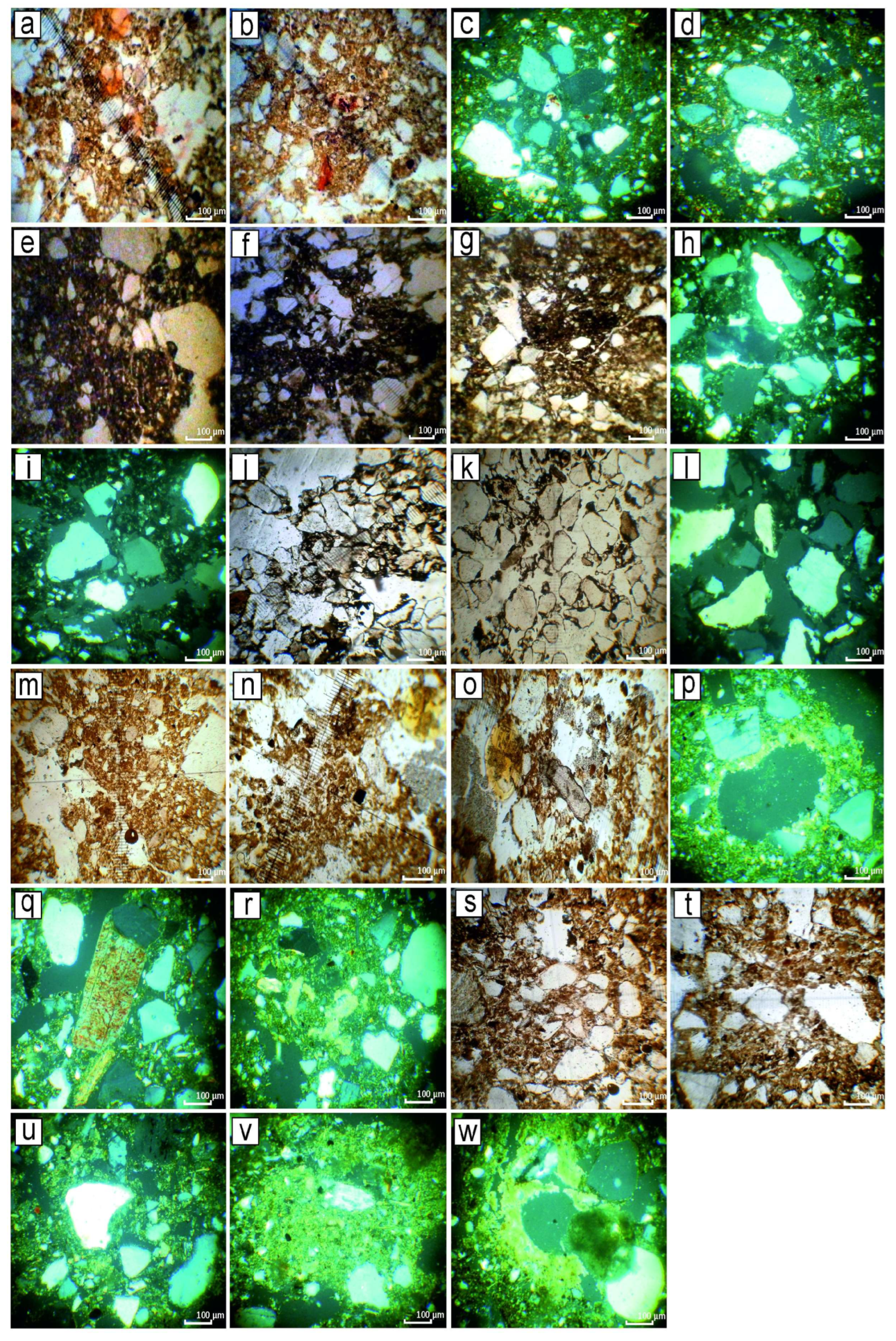
Figure 4.
Kamyane-Zavallia. Soil micromorphology. Captions: see Supplementary Table S1. (a,b,e–g,j,k,m–o,s,t)—PPL (plane-polarised light); (c,d,h,i,l,p–r,u–w)—XPL (cross-polarized light). Magnification 1:70. Elaboration—ZM.
Figure 4.
Kamyane-Zavallia. Soil micromorphology. Captions: see Supplementary Table S1. (a,b,e–g,j,k,m–o,s,t)—PPL (plane-polarised light); (c,d,h,i,l,p–r,u–w)—XPL (cross-polarized light). Magnification 1:70. Elaboration—ZM.

Figure 5.
Mohylna 3. Soil-section 1. Captions: see Supplementary Table S2. Left column: soil horizons’ indices, dotted lines indicate changes of horizons; central column: schematic drawing; right column: photos of actual soil textures from respective horizons of the section, taken afield by gluing a respective sample to a sheet of paper; Elaboration—ZM.

Figure 6.
Humus content in the section 1 of Mohylna 3. Analysis by H.P. Zadverniuk. Elaboration—DK.

Figure 7.
Granulometry of soils in the section 1 of Mohylna 3. Analysis by O.O. Halahan. Legend: sizes of particles in mm. Elaboration—DK.
Figure 7.
Granulometry of soils in the section 1 of Mohylna 3. Analysis by O.O. Halahan. Legend: sizes of particles in mm. Elaboration—DK.

Figure 8.
Kamyane-Zavallia 1. Soil-section 1. Captions: see Supplementary Table S3. Left column: soil horizons’ indices, dotted lines indicate changes of horizons; central column: schematic drawing; right column: photos of actual soil textures from respective horizons of the section, taken afield by gluing a respective sample to a sheet of paper. Elaboration—ZM.

Figure 9.
Kamyane-Zavallia 1. Soil micromorphology. (a,b,e,f,i,n–p)—PPL, (c,d,g,h,j–m)—XPL. Magnification 1:70. Elaboration—ZM.
Figure 9.
Kamyane-Zavallia 1. Soil micromorphology. (a,b,e,f,i,n–p)—PPL, (c,d,g,h,j–m)—XPL. Magnification 1:70. Elaboration—ZM.

Figure 10.
Melnychna Krucha. Soil-section 1. Captions: see Supplementary Table S4. Left column: soil horizons’ indices, dotted lines indicate changes of horizons; central column: schematic drawing; right column: photos of actual soil textures from respective horizons of the section, taken afield by gluing a respective sample to a sheet of paper. Elaboration—ZM.

Figure 11.
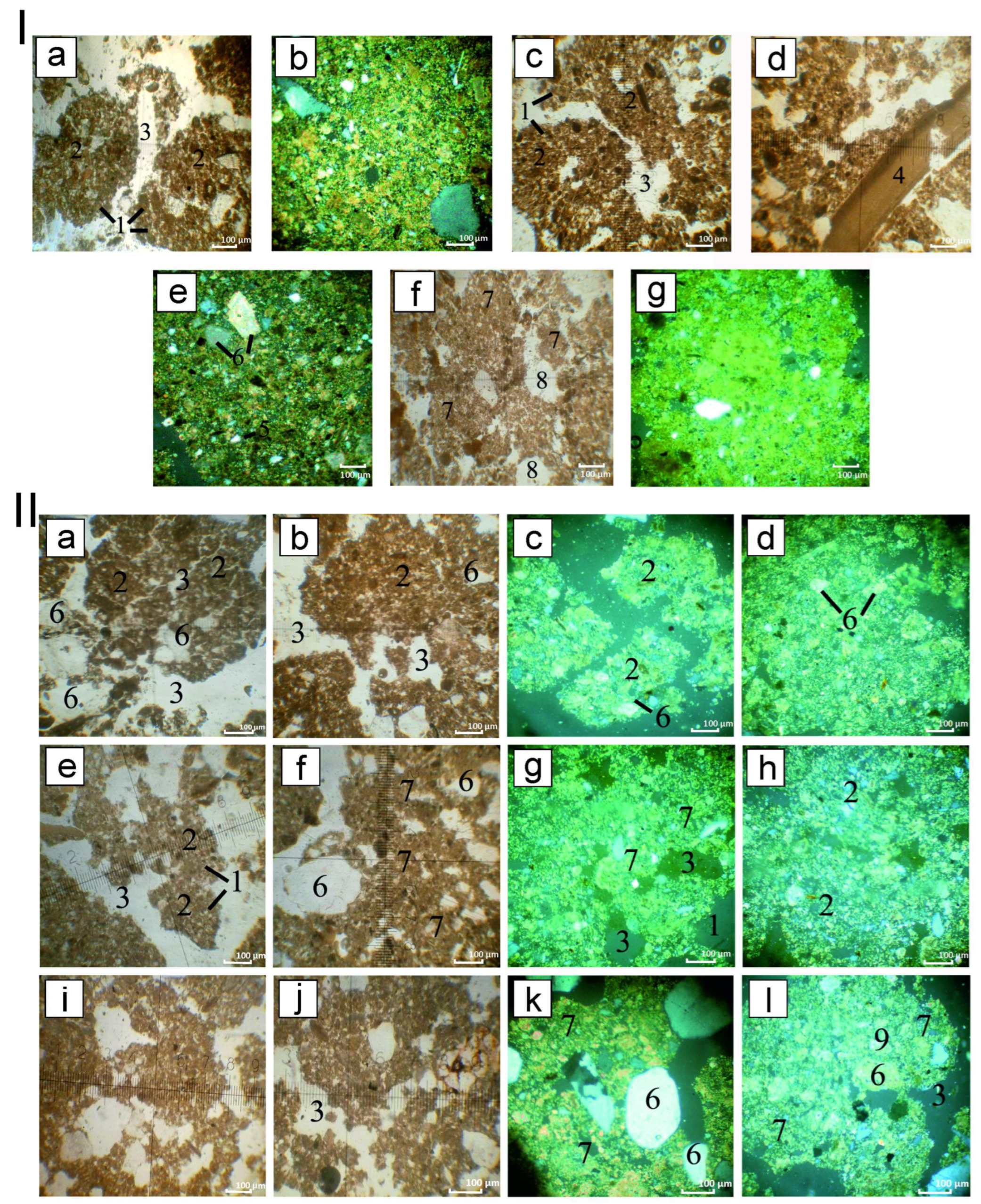
Melnychna Krucha. Micromorphology of soils in the section 1. I—upper soil, (a,c,d,f)—PPL; (b,e,g)—XPL. II—middle soil: Captions: see Supplementary Table S1. Left column: soil horizons’ indices; central column: schematic drawing; right column: photos of the actual soil textures from the respective horizons of the section. (a,b,e,f,i,j)—PPL, (c,d,g,h,k,l)—XPL. Magnification 1:70. Elaboration—ZM.
Figure 11.
Melnychna Krucha. Micromorphology of soils in the section 1. I—upper soil, (a,c,d,f)—PPL; (b,e,g)—XPL. II—middle soil: Captions: see Supplementary Table S1. Left column: soil horizons’ indices; central column: schematic drawing; right column: photos of the actual soil textures from the respective horizons of the section. (a,b,e,f,i,j)—PPL, (c,d,g,h,k,l)—XPL. Magnification 1:70. Elaboration—ZM.

Figure 12.
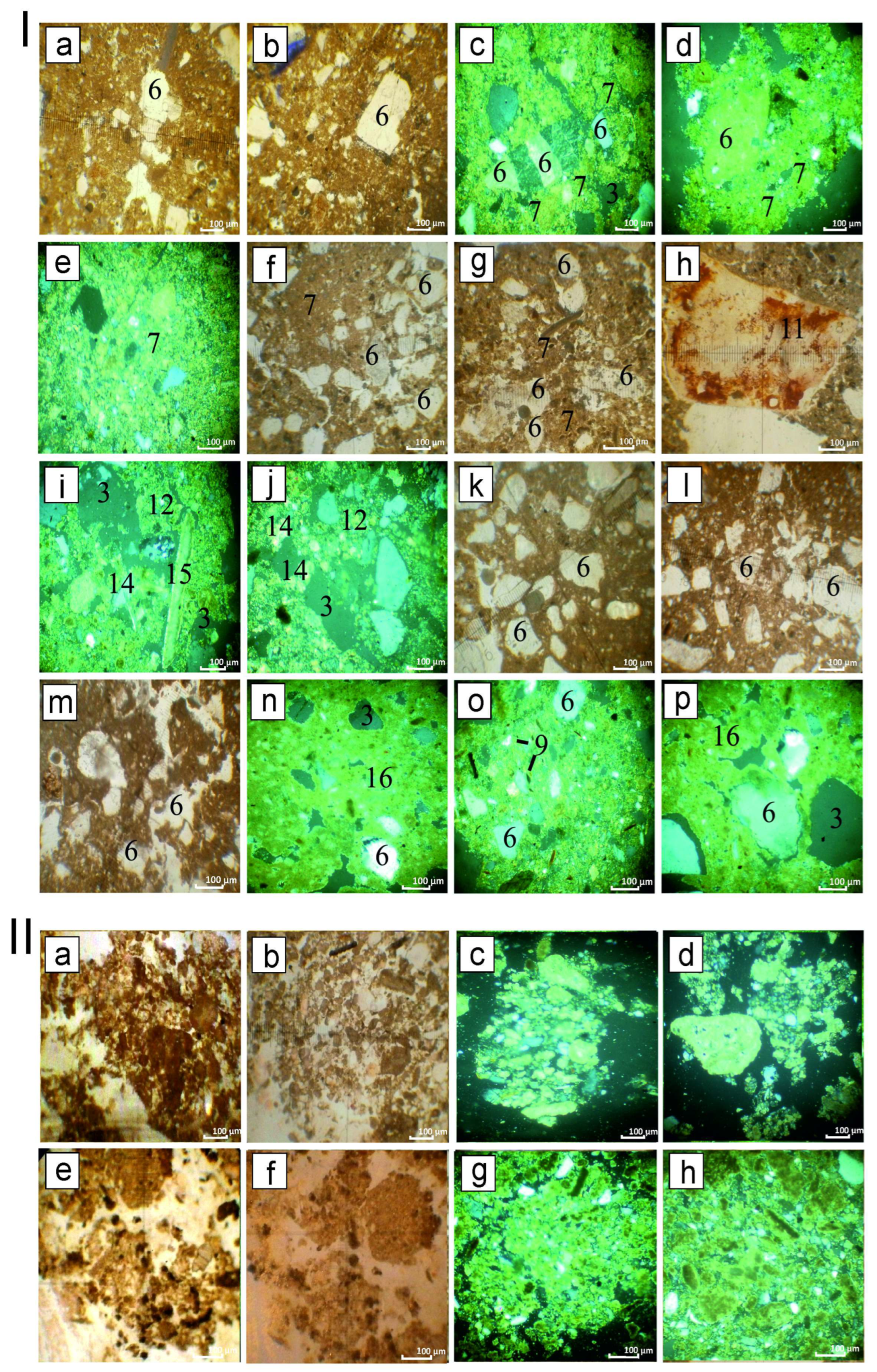
Melnychna Krucha. Micromorphology. I—lower soil of the section 1, (a,b,f–h,k–m)—PPL; (c–e,i,j,n–p)—XPL. II—soils of the section 2. Captions: see Supplementary Table S4. Left column: soil horizons’ indices; central column: schematic drawing; right column: photos of the actual soil textures from the respective horizons of the section. (a,b,e,f)—PPL, (c,d,g,h)—XPL. Magnification 1:70. Elaboration—ZM.
Figure 12.
Melnychna Krucha. Micromorphology. I—lower soil of the section 1, (a,b,f–h,k–m)—PPL; (c–e,i,j,n–p)—XPL. II—soils of the section 2. Captions: see Supplementary Table S4. Left column: soil horizons’ indices; central column: schematic drawing; right column: photos of the actual soil textures from the respective horizons of the section. (a,b,e,f)—PPL, (c,d,g,h)—XPL. Magnification 1:70. Elaboration—ZM.

Figure 13.
Melnychna Krucha. Soil-section 2. Captions: see Supplementary Table S4. Left column: soil horizons’ indices, dotted lines indicate changes of horizons; central column: schematic drawing; right column: photos of actual soil textures from respective horizons of the section, taken afield by gluing a respective sample to a sheet of paper. Elaboration—ZM.

Figure 14.
Mykolyna Broiaka. Soil-section 1. Captions: see Supplementary Table S5. Left column: soil horizons’ indices, dotted lines indicate changes of horizons; central column: schematic drawing; right column: photos of actual soil textures from respective horizons of the section, taken afield by gluing a respective sample to a sheet of paper. Elaboration—ZM.

Figure 15.
Mykolyna Broiaka. Organic carbon content in soil-section 1. Analysis by H.P. Zadverniuk. Elaboration—DK.
Figure 15.
Mykolyna Broiaka. Organic carbon content in soil-section 1. Analysis by H.P. Zadverniuk. Elaboration—DK.

Figure 16.
Mykolyna Broiaka. Granulometry in soil-section 1. Legend: sizes of particles, in mm. Analysis by O.O. Halahan. Elaboration—DK.
Figure 16.
Mykolyna Broiaka. Granulometry in soil-section 1. Legend: sizes of particles, in mm. Analysis by O.O. Halahan. Elaboration—DK.


Table 1.
Relevant radiocarbon dates.
| Lab No. | Site | Material | Context | Age_Uncal (y BP) | ±1s (y) | Period/Culture | CalBC (1 σ) | CalBC (2 σ) | Reference |
|---|---|---|---|---|---|---|---|---|---|
| BE-7636 | MK-SU4 | Animal bone | Cultural layer | 8368 | 23 | Kukrek | 7509–7379 | 7520–7357 | Kiosak et al., 2021 |
| BE-7635 | MK-SU4 | Animal bone | Cultural layer | 8311 | 24 | Kukrek | 7454–7345 | 7480–7315 | Kiosak et al., 2021 |
| BE-10309 | MK-SU4 | Animal bone | Cultural layer | 8344 | 23 | Kukrek | 7483–7362 | 7497–7347 | Kiosak et al., 2021 |
| Poz-67496 | MK-SU3 | Angiosperm | Cultural layer | 7520 | 50 | Late Mesolithic | 6448–6361 | 6461–6252 | Kiosak, Salavert 2018 |
| BE-7639 | MK-SU3 | Animal bone | Under the shell pile | 7436 | 23 | Late Mesolithic | 6367–6256 | 6381–6241 | Kiosak et al., 2021 |
| BE-10308 | MK-SU3 | Animal bone | Cultural layer | 7404 | 23 | Late Mesolithic | 6352–6233 | 6365–6230 | Kiosak et al., 2021 |
| Poz-67497 | MK-SU3 | Ash charcoal | Cultural layer | 7380 | 40 | Late Mesolithic | 6356–6216 | 6380–6100 | Kiosak, Salavert 2018 |
| BE-7637 | MK-SU2 | Animal bone | Bone scatter | 6980 | 24 | Para-Neolithic | 5962–5815 | 5976–5787 | Kiosak et al., 2021 |
| BE-7641 | MK-SU2 | Antler | Bone scatter | 6986 | 24 | Para-Neolithic | 5966–5841 | 5977–5794 | Kiosak et al., 2021 |
| BE-7638 | MK-SU2 | Animal bone | Bone scatter | 6985 | 22 | Para-Neolithic | 5963–5841 | 5976–5798 | Kiosak et al., 2021 |
| BE-7640 | MK-SU2 | Antler | Cultural layer | 6812 | 24 | Para-Neolithic | 5722–5674 | 5736–5651 | Kiosak et al., 2021 |
| Ki-14790 | Gard | Pottery carbon | Lower layer | 6630 | 90 | Para-Neolithic | 5630–5490 | 5721–5385 | Tovkailo 2014 |
| Ki-14789 | Gard | Pottery carbon | Lower layer | 6480 | 80 | Para-Neolithic | 5520–5360 | 5612–5310 | Tovkailo 2014 |
| Ki-14791 | Gard | Pottery carbon | Upper layer | 6710 | 80 | Para-Neolithic | 5710–5560 | 5734–5489 | Tovkailo 2014 |
| Ki-14792 | Gard | Pottery carbon | Upper layer | 6520 | 80 | Para-Neolithic | 5560–5370 | 5618–5338 | Tovkailo 2014 |
| Ki-14793 | Gard | Pottery carbon | Upper layer | 6400 | 90 | Para-Neolithic | 5480–5310 | 5546–5210 | Tovkailo 2014 |
| BE-18269 | MB | Animal bone | House 1, 280 cm deep | 6762 | 27 | Para-Neolithic | 5708–5631 | 5719–5625 | Kiosak et al. sbm |
| BE-18270 | MB | Animal bone | sq. 2-E, 268 cm deep | 5731 | 26 | Para-Neolithic | 4647–4505 | 4678–4493 | Kiosak et al. sbm |
| Ki-9833 | Dobrianka-1 | Pottery carbon | Cultural layer | 6530 | 140 | Para-Neolithic | 5616–5370 | 5714–5224 | Zalizniak et al., 2013 |
| Ki-9834 | Dobrianka-1 | Pottery carbon | Cultural layer | 6360 | 150 | Para-Neolithic | 5490–5080 | 5616–4991 | Zalizniak et al., 2013 |
| OxA-17490 | Dobrianka-3 | Animal bone | Cultural layer | 9115 | 45 | Mesolithic | 8420–8272 | 8454–8252 | Lillie et al., 2009 |
| OxA-222-33 * | Dobrianka-3 | Human bone | Burial | 7227 | 40 | Mesolithic | 6202–6028 | 6210–6018 | Lillie et al., 2009 |
| Ki-11105 | Dobrianka-3 | Animal bone | Cultural layer | 7400 | 130 | Para-Neolithic | 6411–6106 | 6474–6016 | Zalizniak et al., 2013 |
| Ki-11104 | Dobrianka-3 | Animal bone | Cultural layer | 7320 | 130 | Para-Neolithic | 6354–6058 | 6441–5933 | Zalizniak et al., 2013 |
| Ki-11108 | Dobrianka-3 | Animal bone | Cultural layer | 7260 | 170 | Para-Neolithic | 6354–5987 | 6452–5808 | Zalizniak et al., 2013 |
| Ki-11106 | Dobrianka-3 | Animal bone | Cultural layer | 7070 | 150 | Para-Neolithic | 6068–5777 | 6232–5642 | Zalizniak et al. 2013 |
| Ki-11107 | Dobrianka-3 | Animal bone | Cultural layer | 7050 | 160 | Para-Neolithic | 6056–5756 | 6232–5642 | Zalizniak et al., 2013 |
| GrA-33115 | Dobrianka-3 | Animal bone | Cultural layer | 4400 | 35 | Para-Neolithic | 3088–2928 | 3308–2910 | Biagi et al., 2007 |
| GrA-33117 | Dobrianka-3 | Animal bone | Cultural layer | 3595 | 35 | Para-Neolithic | 2013–1902 | 2113–1831 | Biagi et al., 2007 |
| Poz-67121 | KZ | Bone | Pit 1 | 6200 | 40 | LPC | 5207–5058 | 5212–5042 | Kiosak 2017 |
| Poz-67554 | KZ | Acer sp. Charcoal | Pit 1 | 6130 | 40 | LPC | 5287–5079 | 5296–5072 | Kiosak 2017 |
| BE-7649 | MIII | Bone | Close to Ploschadka | 5712 | 22 | Trypillia A3 | 4580–4501 | 4616–4466 | Kiosak et al., 2021 |
| BE-16908 | MIII | animal bone | Soil-section 1 | 5699 | 26 | Trypillia A3 | 4549–4459 | 4607–4453 | Kiosak et al., sbm |
| BE-16909 | MIII | animal bone | Soil-section 1 | 5679 | 27 | Trypillia A3 | 4539–4458 | 4599–4447 | Kiosak et al., sbm |
| BE-7652 | KZ 1 | Bone | Inner ditch | 5346 | 21 | Trypillia B1 | 4252–4076 | 4315–4056 | Kiosak et al., 2021 |
| BE-7651 | KZ 1 | Bone | Inner ditch | 5424 | 21 | Trypillia B1 | 4331–4263 | 4337–4251 | Kiosak et al., 2021 |
MK—Melnychna Krucha, SU—stratigraphic unit, MB—Mykolyna Broiaka, MIII—Mohylna 3, KZ—Kamyane-Zavallia. * Kyiv radiocarbon dates on the potsherds have shown a poor agreement with dates from other laboratories and should be treated with extreme caution [14].
Disclaimer/Publisher’s Note: The statements, opinions and data contained in all publications are solely those of the individual author(s) and contributor(s) and not of MDPI and/or the editor(s). MDPI and/or the editor(s) disclaim responsibility for any injury to people or property resulting from any ideas, methods, instructions or products referred to in the content. |
© 2023 by the authors. Licensee MDPI, Basel, Switzerland. This article is an open access article distributed under the terms and conditions of the Creative Commons Attribution (CC BY) license (https://creativecommons.org/licenses/by/4.0/).
Share and Cite
MDPI and ACS Style
Kiosak, D.; Matviishyna, Z. The Soils of Early Farmers and Their Neighbors in the Southern Buh Catchment (Ukraine): Micromorphology and Archaeological Context. Land 2023, 12, 388. https://doi.org/10.3390/land12020388
AMA Style
Kiosak D, Matviishyna Z. The Soils of Early Farmers and Their Neighbors in the Southern Buh Catchment (Ukraine): Micromorphology and Archaeological Context. Land. 2023; 12(2):388. https://doi.org/10.3390/land12020388
Chicago/Turabian StyleKiosak, Dmytro, and Zhanna Matviishyna. 2023. "The Soils of Early Farmers and Their Neighbors in the Southern Buh Catchment (Ukraine): Micromorphology and Archaeological Context" Land 12, no. 2: 388. https://doi.org/10.3390/land12020388
Note that from the first issue of 2016, this journal uses article numbers instead of page numbers. See further details here.