Article

Old-Growth Forests in Urban Nature Reserves: Balancing Risks for Visitors and Biodiversity Protection in Warsaw, Poland

1
Institute of Biological Sciences, Faculty of Biology and Environmental Sciences, Cardinal Stefan Wyszynski University, 01-938 Warsaw, Poland
2
Landscape Ecology Lab, Geography Department, Humboldt-Universität zu Berlin, Unter den Linden 6, 10099 Berlin, Germany
3
Department of Computational Landscape Ecology, Helmholtz Centre for Environmental Research, UFZ, 04318 Leipzig, Germany
*
Author to whom correspondence should be addressed.
Land 2023, 12(2), 275; https://doi.org/10.3390/land12020275
Submission received: 30 November 2022 / Revised: 10 January 2023 / Accepted: 16 January 2023 / Published: 18 January 2023
(This article belongs to the Special Issue Recent Progress in Urban Forest Planning and Monitoring)

Abstract

:

Highlights

  • Airborne LiDAR data are used to assess defoliation in old-growth forest stands in Warsaw, Poland
  • It was found that defoliated trees are often of old age and cause severe risks to visitors in the two assessed urban nature reserves.
  • Both reserves were affected by a severe winter storm and closed to visitors and old trees valuable for biodiversity were cut at a high rate, respectively.
  • The proposed methodology helps predict risks to visitors and can be used to develop precise visitor management, visitor information, and other targeted measures to ensure trade-offs between biodiversity potential and visitor risks are minimal.

Abstract

Urban nature reserves in Poland are precious relics of ancient nature with preserved biodiversity. They consist of valuable trees several 100 years old, are biodiverse, and are valuable recreational spaces right in and around cities. It is therefore critical to manage tradeoffs between visitor safety due to, e.g., falling dead branches and the need for old-grown trees for biodiversity conservation. This study aimed to determine whether airborne laser scanning data (LiDAR) can confirm that trees exhibiting the worst crown defoliation are the first to be damaged in storms. Our results show that during Storm Eunice in 2022, the detected defoliated trees, in fact, were damaged the most. Despite such evidence available to the city, no targeted changes to the management of the reserves were taken after the storm. One of the forests was completely closed to visitors; in the other forest, areas with damaged trees were fenced off, and then, the remaining branches and fallen trees were removed to make the forest available for recreation. Using available evidence such as LiDAR data, we propose more targeted and nuanced forms of managing biodiversity conservation in conjunction with visitor safety. This includes the establishment of priority areas, visitor information, and visitor management. This way, airborne laser scanning and Geographic Information Systems can be used to balance management needs accounting for both biodiverse old-grown forest structures while at the same time providing added safety for visitors.

1. Introduction

Urban forests are valuable sources of nature and biodiversity of flora and fauna in cities, providing psychological and recreational benefits that contribute positively to the well-being of individuals [1,2,3,4,5]. These benefits often indicate their importance as a place of rest, such as events, tourism, and the way to get to work or spend free time [1,6]. Urban forests can generate significant ecosystem services (ES) such as ecological benefits (e.g., wildlife habitat and connectivity) [7,8], economic benefits (e.g., improved hospital recovery times and reduced crime rates) [9,10], offsetting carbon emission [1], removing air pollutants, reducing noise, regulating the local climate [11,12,13], health [13,14] cultural benefits (e.g., recreation), esthetic values, and amenity [5,15,16,17]. In this direction, linking ES and people’s preferences to forest recreation can be a component of supporting and informing socio-ecological interfaces around recreation in biodiverse areas [13,18].
Forests are of outstanding importance in biodiversity protection in the urban environment, especially in highly urbanized areas where natural habitat remains scarce otherwise. Multiple red-list and endangered species can be found in urban forests [18,19]. Especially important in this regard are old trees, amplifying the value of urban forests as refuges of biodiversity. At the same time those forests are often also active places of recreation Maintaining the biodiversity that old trees can support is associated with limited interference through care works, e.g., cutting down old trees or fallen branches. This in turn can pose threats to the safety of visitors, can hinder recreation in forests, and can cause injuries. Managers often exclude these places from recreation, which makes outdoor moving (such as running, walking, and cycling) in urban forests difficult and causes public dissatisfaction [20].
This highlights that urban forests face a multitude of management challenges, ranging from implications of climate change that lead to an uncertain and complex future for urban forests [21,22] to impoverished or disturbed soils to strategic challenges such as the lack of relevant policies and inadequate operating budgets [23,24]. The combination of the issues of management and benefits of urban forests and natural protected areas with their recreational function, especially in Poland, is an increasing problem and challenges city managers [18,25].
Remote sensing (RS) has been developing intensively in recent years and provides a range of solutions that can be successfully used for inventory and monitoring of greenery in the city, mainly trees. RS is engaged in the acquisition and processing of data obtained though the registration of emitted electromagnetic radiation with the use of specialized sensors. This data can be recorded from different platforms: satellites, aircraft, air and ground unmanned vessels [26,27,28,29,30].
In this study, two forests in Warsaw were analyzed: the Bielański Forest and the Kabacki Forest, which are under species protection (nature reserves) and are recreational areas of Warsaw. Moreover, due to numerous storms, together with compound hot and dry events in recent years, urban forests in Poland have been damaged. Therefore, research on LiDAR (light detection and ranging) and its products, such as the High Structural Diversity Tree Crown Map for Warsaw from 2018 to 2020, is a new tool that can find new applications in the monitoring of larger urban green infrastructures and urban forests [26].
In this study, we focus on the biodiversity and recreation by inhabitants in two urban forests (nature reserves) in Warsaw in Poland. This dissimilarity needs to be addressed especially in the cases included, where the forest area has recreational functions but also has intensive tree growth, where human interference in care is limited due to legal regulations. Hence, the areas where compromises appear or may appear and the priority setting for forest health, people’s safety, tree species patterns, and forest management were specified in this study.
In urban nature reserves, both the value for biodiversity and the accessibility for visitors need to be regarded in management. In cities the need for recreation and leisure in natural areas is high due to the lack of similar areas for active recreation in cities, and the only way for some urban residents to get in contact with nature which could be limited due to nature preservation of local law [4,18,20,27,28,29,30,31,32,33,34].
Safeguarding visitors is particularly important in the context of the increasing frequency of weather anomalies, the “new climate normal” [4,35]. Knowing that nature reserves are subjected to minimal care activities in Poland, also their health monitoring is rather marginal, which distinguishes these places from other green parks or street trees, which are much better monitored and examined in the context of plant health needs [4,31,32]. It is this issue that we decided to undertake the research in this article; specifically, we ask the following research questions:
  • What is the species diversity of the defoliated trees against the background of the total forest trees in the areas under consideration?
  • What is the risk pattern in both forest reserves associated with defoliated trees?
  • What is the impact of Storm Eunice (Feb. 2022), and which species were most severely affected?
  • How accurately can we predict the risks for visitors using ALS (airborne laser scanning) data, and what suggestions for management can we derive from them for the combined protection of visitors and biodiversity?

2. Literature Review: The Use of Tree Crown Mapping to Monitor Urban Nature Reserves

Biodiversity in urban forests faces increasing pressures due to human and natural influences that alter vegetation structure. Because of the inherent difficulty of measuring forested vegetation’s multidimensional structure on the ground assessments are often restricted to local measurements [33]. Our study fills this gap using remote sensing in the management of biodiversity-related issues, which is underrepresented in urban RS literature [27,28,29,34,35,36,37]. Sensor data of places known to people can broaden discussion regarding climate change or the role of forest trees in cities [35,38,39], making monitoring technologies and the data they produce valuable [40]. Thus, forest management in urban and peri-urban areas can largely benefit from air-/space-borne methods as the effects of LiDAR can be widespread, whereas forest staff methods and tools to monitor the health of trees are often limited [40,41,42,43,44,45,46,47,48,49,50]. What is more, this subject seems reasonable to find a compromise between the protection of forest biodiversity and the possible ways of active recreation of visitors and their safety [13]. It can be presumed that a clear reason for considering the problems of urban ecology is that a “forest is not equal to a forest” due to threats and disruptions of forest functions understood as ecosystem services.
Airborne laser scanning is a tool for detailed local assessments and can be used for tree crown mapping [26,27,28,29,51,52,53]. In the RS literature, we can find papers using LiDAR as a measure of vegetation cover [54]. These data are often understood under various names, e.g., as airborne LiDAR data [55], and each time require checking the data acquisition, e.g., Sentinel-2 [45,56] or ALS [57]. In Poland, LiDAR is most often used in environmental monitoring by foresters [56,57,58,59]. Globally, it is often used to measure forest density, e.g., in Australia [54], or measurements of woodlands using GEOBIA and the program from Worldview 2 [60] and ecosystems by using high-resolution imagery through object-based image analysis [61], e.g., forests in Africa. A category of novelty in environmental monitoring is mapping the biodiversity of heterogeneous landscapes using LiDAR and ecoacoustics [62] and mapping canopy dominant trees based on some indicators, i.e., temperature [63]. It is becoming more and more common to measure street trees using hyperspectral imagery [50,64] e.g., in some cities in Central Europe like Leipzig [4]; as well as to measure selected green areas using UAV (Unmanned Aerial Vehicle) [65], e.g., SOWA, often in Poland use to control also AQI (Air Quality Index) [57].
As is presented in RS literature, the papers point out that LiDAR technology could be used to obtain spatial information on forest characteristics, but tree species identification is still challenging. However, there are a few papers indicating the biodiversity of green areas, especially large ones, e.g., on a regional scale in China [53] or on a city scale in Poland in Warsaw [26,27,28,29]. In the case of the High Structural Diversity Tree Crown Map for Warsaw, due to the large area of the city (517 km2), ALS is divided into two stages. First, in 2018, the northern part of the city was raided, including the Bielański Forest. Secondly, in 2020, the southern part of the city, including Kabacki Forest, was raided. In total, an inventory of 9,000,000 pts. of trees was measured by ALS in Warsaw [65]. During the ALS, the following conditions had to be observed: adequate sunny weather during the vegetation period and clear skies. The map is originally called the Tree Crown Map (pl. “Mapa koron drzew”). It is also available online in basic views. In our research, its name is refined due to the parameters showing the species differentiation of trees [66]. This makes it possible to distinguish the ALS map from similar maps such as the National Tree Crown Map (pl. “Krajowa mapa koron drzew” or “mapa koron drzew”), which shows the site globally accessible through RS online monitoring but shows only the height and distribution of trees based on Sentinel-2 satellite data [67]. Besides all those developments in remote sensing the topic of biodiversity assessments in urban nature reserves with the application of LiDAR is still to be explored.

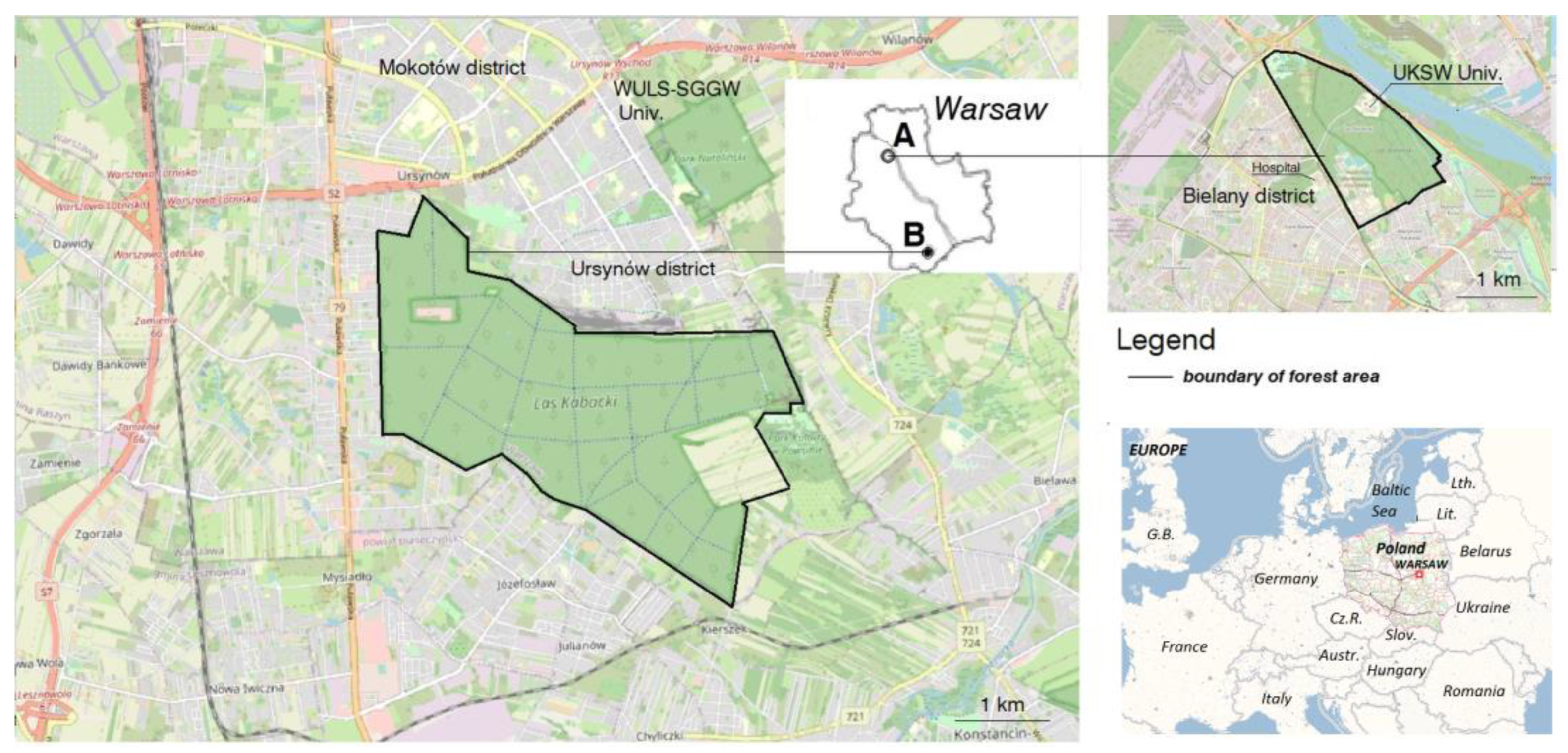
3. Case Introduction

In our study we assessed the Bielański Forest and the Kabacki Forest, which are both located in the city of Warsaw (area 52,720 ha, population: 1,860,281) in Central Poland. Both cases are relics of the former Mazovian fluff, with the oldest trees ranging in age from 300 to 400 years [68,69,70,71]. These forests are nature reserves where human interference is ought to be reduced. Care treatments in these forests are carried out sporadically, which are mostly limited to the removal of dry fallen branches on pedestrian and bike paths. The guidelines for landscape protection (pl. Plan ochrony lasu) [72] of nature reserves are based on minimizing these threats by establishing a new protection plan, which is an obligatory document for nature reserves in Poland.
In the Bielański Forest, nature protection is additionally necessary due to excessive visitor movements because of the location of a university in the center of the forest and active forms of recreation by residents. In Poland, it is common to use forests for recreational or tourist purposes due to the lack of green areas that may relieve reserves from anthropogenic pressure [73,74]. The Bielański Forest nature reserve is in the Bielany District in the northern part of Warsaw (Figure 1A). It covers an area of 130.35 ha. It is under the protection of the Nature 2000 Area (PLH 140041), which protects important European forest habitats and species. It is the remnant of the former Mazovia Primeval Forest, which has 300–400-year-old oak trees and many other tree nature monuments [71].
The Kabacki Forest nature reserve is in the Ursynów District in the southern part of Warsaw (Figure 1B). It covers an area of 903.53 ha, which is seven times larger than the Bielański Forest. It is also under nature protection (Warsaw Landscape Protection Area site), with numerous natural monuments and a valuable natural landscape of Mazovia [71].
The effects that Storm Eunice had on Bielański Forest and the Kabacki Forest were analyzed in this study. Storm Eunice was an intense extratropical cyclone in February 2022 doing damage in Western and Central Europe with recorded wind speeds of over 130km/h. In the Kabacki Forest, Storm Eunice knocked down multiple old trees. This led the local authorities to temporarily close the forest for about one month. In the Bielański Forest, the effect of the storm was weaker, and only a few ill trees were knocked down [69,70]. Hence, it was not closed, but the trees posed a real threat to the inhabitants, similar to the case of the Kabacki Forest.
Both forests are located in the Warsaw escarpment along the Vistula River. They represent two major green spaces for recreation for Warsaw residents, the Bielański Forest in the north and the Kabacki Forest in the south. These two forest areas were most strongly affected by the storm.

4. Methodology

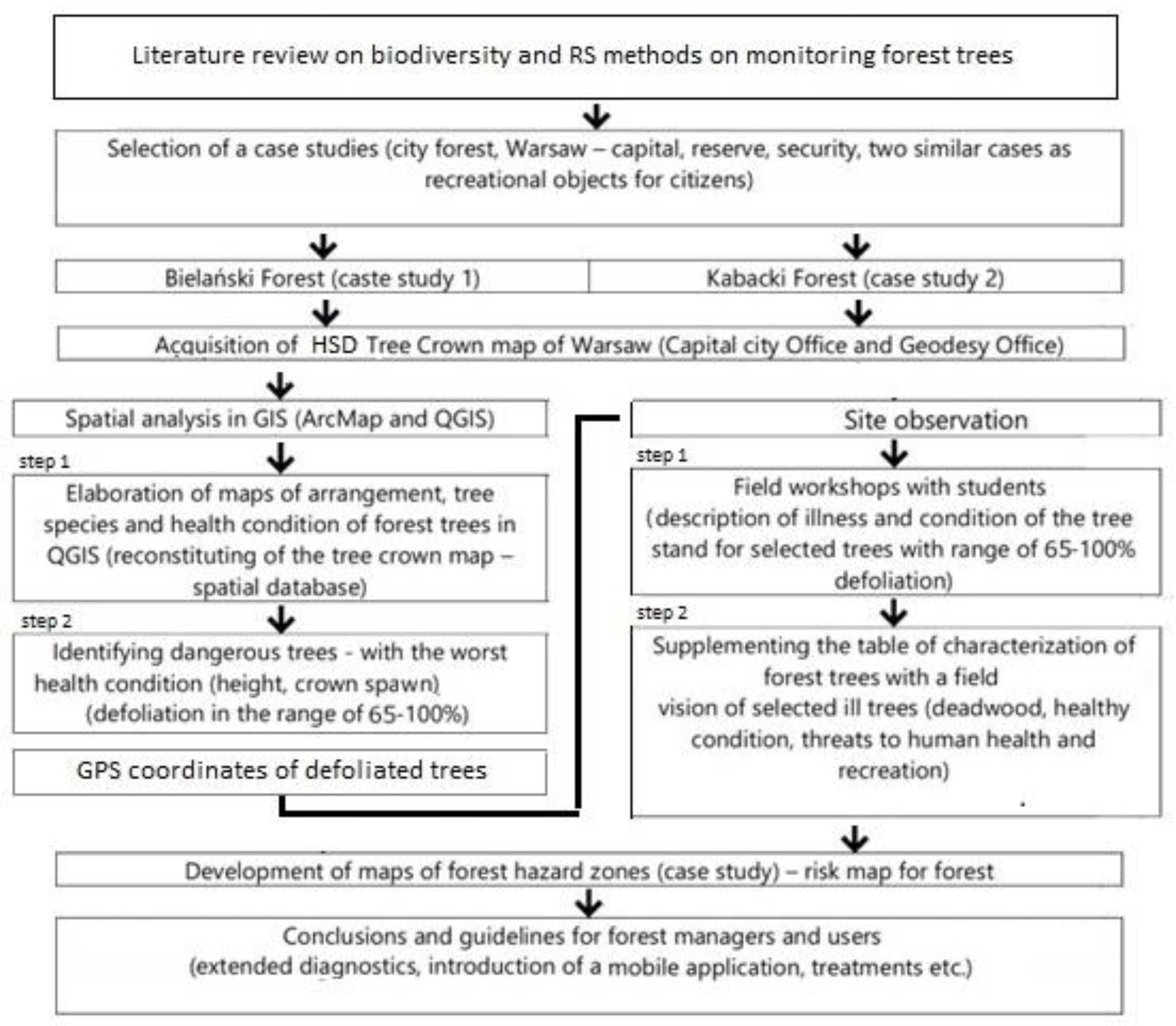
4.1. Research Framework

The research framework of the present study is described below. It consists of, first, a literature review on biodiversity and LiDAR regarding tree crown mapping. Secondly, two similar urban forest areas (urban nature reserves) were selected, both of which are important for recreation in Warsaw. Second, spatial analysis was performed in QGIS, using the High Structural Diversity Crown Map of the selected forests, finding areas with the highest index of defoliation (presented in Tables S1 and S2). Based on the collected data, two steps were done, as follows: (1) biodiversity maps for defoliated trees (range 65–100% defoliation), and (2) the maps of the dangerous trees (defoliated trees) were created for both forests. Based on the highlighted locations, the coordinates of the weakest trees in both cases were localized in the database and mapped in QGIS (an Open-Source Geographic Information System). Using these locations, site observations were performed in tow steps, as follows: (1) field workshops with health condition analyzes of the selected trees, in which deadwood, broken branches, humus diseases, leaning trees, and threats to human health and recreation were evaluated, (2) supplementing the tables of defoliated trees of their health characteristic including height and health conditions were done. Based on GIS information and field mapping hazard maps with dangerous trees were created with safety buffer zones around them. Finally, further directions for development and guidelines for local authorities and citizens and the application of this research in the future in similar cases and scientists in the fields of urban ecology, landscape architecture, forestry, dendrology, and RS were presented (Figure 2).

4.2. Materials

In the years 2018–2020, the municipality of Warsaw city acquired three products from MGGP Aero SA company: (1) laser scanning (ALS), (2) hyperspectral imaging, and (3) multispectral imaging. The Hyspex hyperspectral scanner recorded radiation in the 400–2500 nm range using three sensors. The multispectral resolution of the data was 0.1 m. The number of spectral channels was 3 (RGB). The average scanning density of the LiDAR dataset was 14 points per 1 square meter. Tree crown information (CHM) was obtained from the point cloud [26].
Finally, the database provided by the City of Warsaw included (1) tree crown coverage maps with a table of attributes, (2) tree taxon maps, (3) tree biological condition taxon maps, including indicator maps of discoloration and defoliation, and also Normalized Difference Vegetation index (NDVI), Red Edge Normalized Difference Vegetation Index, Modified Chlorophyll Absorption Ratio Index (MCARI), Structure Intensive Pigment Index, Plant Senescence Reflectance Index (PSRI), and Moisture Stress Index (MSI) [26,77]. The spatial database for both cases (Eng. High Structural Diversity Trees Crown Map, pl. Mapa Koron Drzew m.st. Warszawy, GIS version), consisting of maps developed in the form of individual layers, was searched for the following parameters: tree crown extent maps with attribute tables, tree taxa maps, indicator tree defoliation maps (% defoliation), and indicator tree health maps (ALS) [78]. The High Structural Diversity Tree Crown Map is made available for scientific and didactic purposes for the Bielański Forest (ALS recorded in 2018) and the Kabacki Forest (ALS recorded in 2020). The database is provided as appendices (tables of attributes of defoliated trees for the Bielański Forest—Table S1, and for the Kabacki Forest—Table S2).

4.3. Methods

A mixed-method approach was used in the present study, which is based on the following factors:
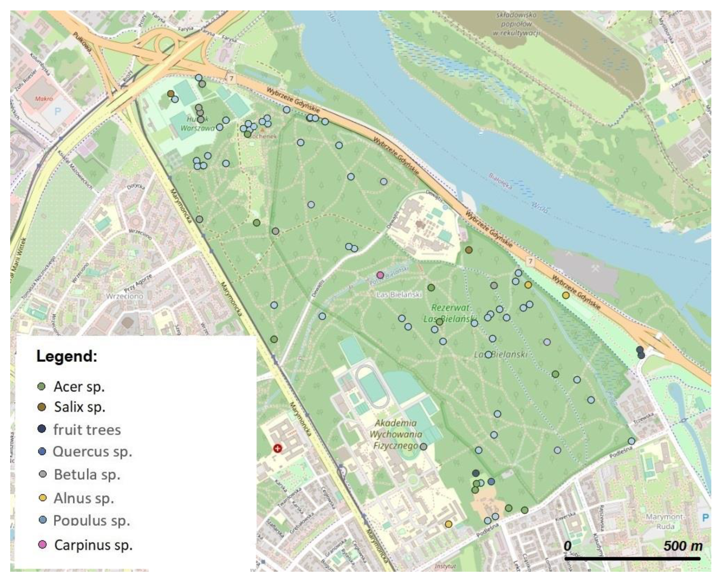
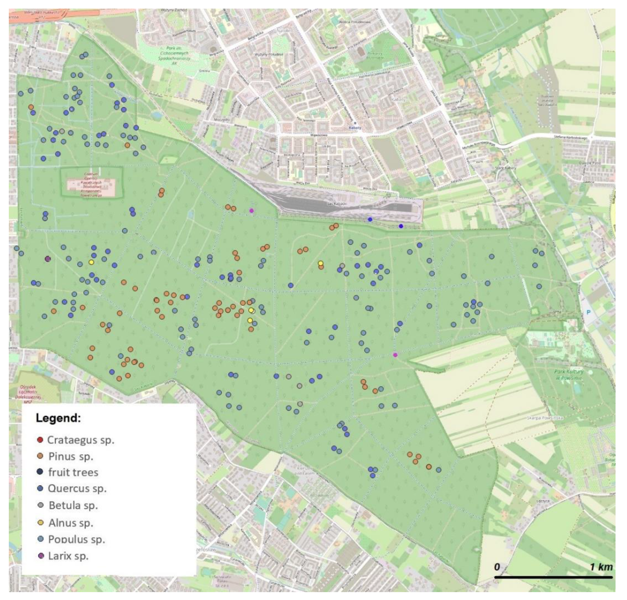
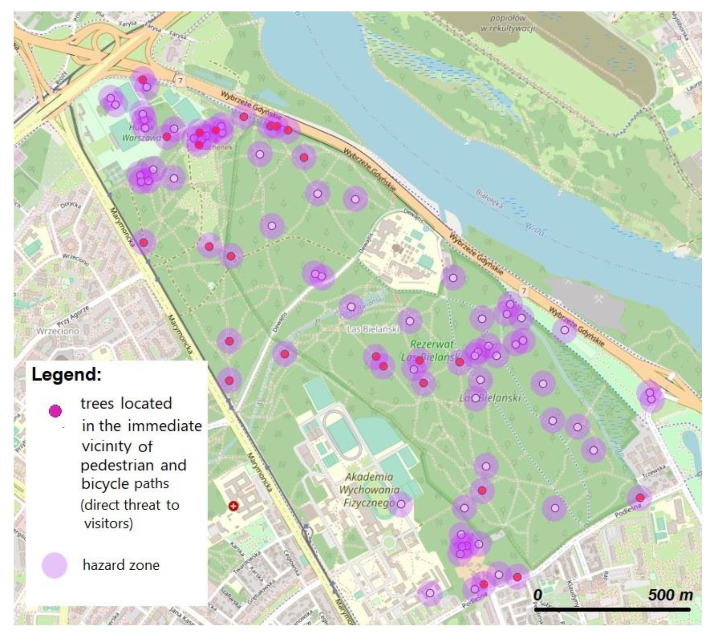
  • Mapping of trees with high defoliation (65–100%) based on the LiDAR derived information in the High Structural Diversity Tree Crown Map of Warsaw [78]. To classify defoliation levels, 10% steps and then classification using natural breaks depending on data distribution was employed. ArcMap 10.5 and QGIS 9.12. Software was used for map creation. Class breaks were calculated using the natural breaks optimization procedure described by Jenks as illustrated and described in the studies by North et al., Chen, Khamis, et al., and others [77,79,80].
  • Elaboration of the database for defoliated trees and risk maps. ArcMap 10.5 and QGIS 9.12.
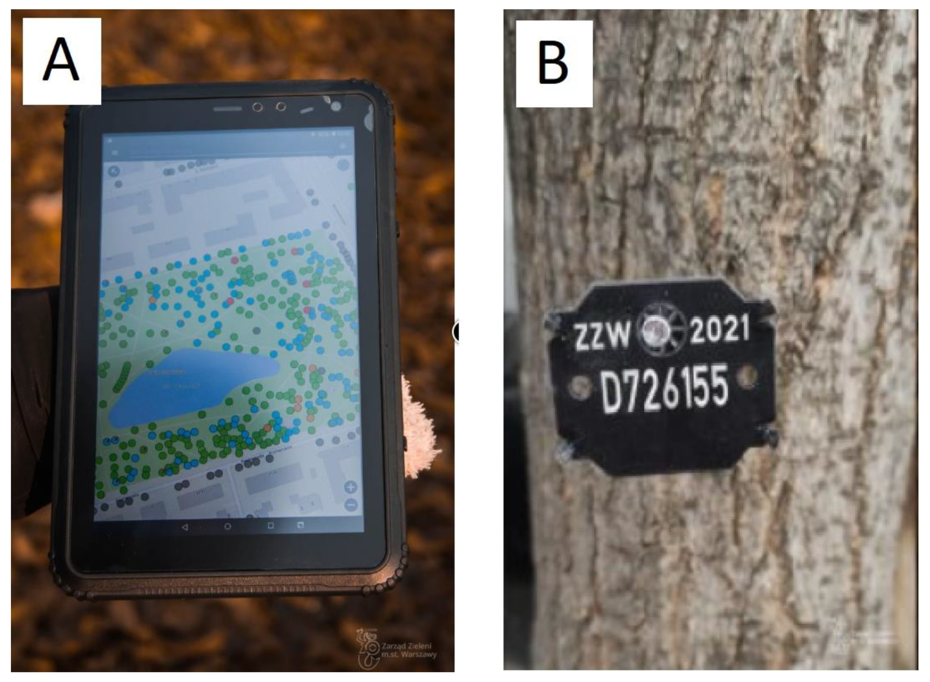
  • Fieldwork: GPS localization of the selected defoliated trees in both forests was carried out. GPS data was recorded with a Garmin GPSMAP 60CSx GPS receiver) and converted using the MapSource software.
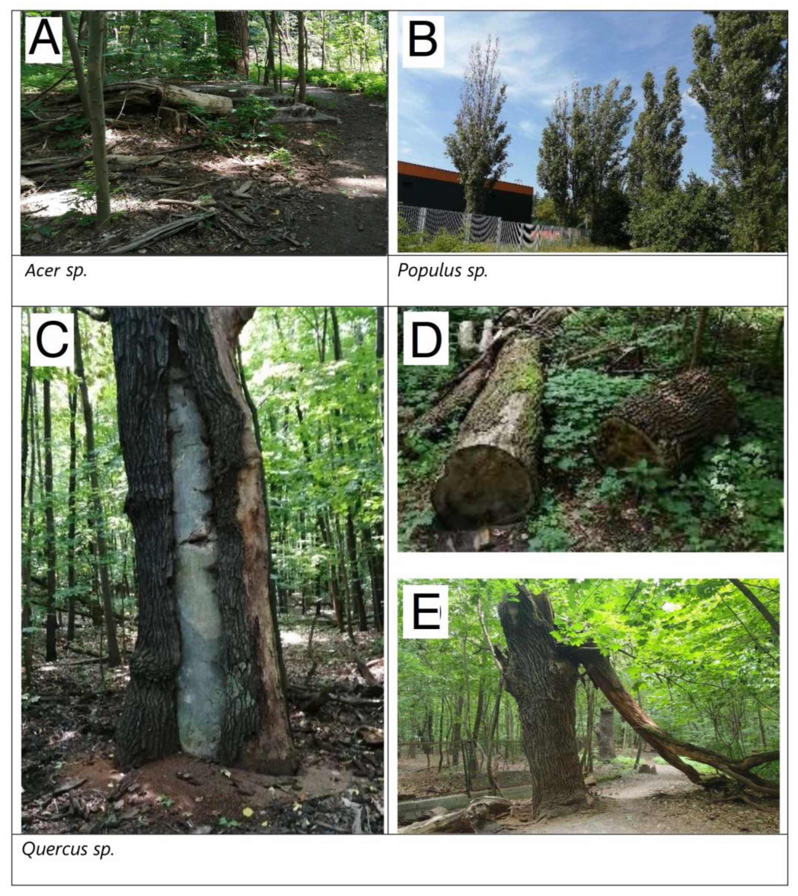
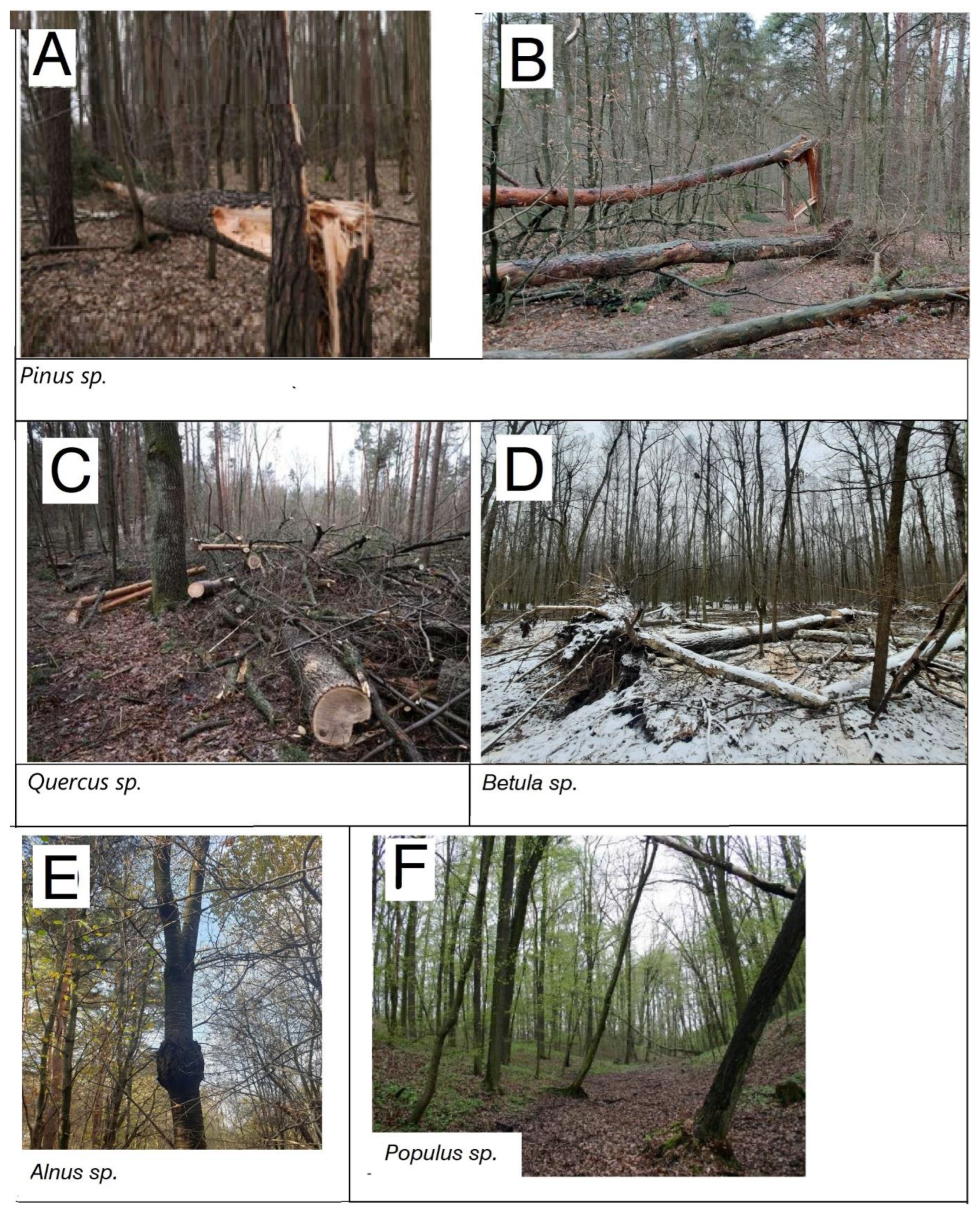
  • Site observation of the selected defoliated trees in both forests was made according to landscape architecture and urban ecology research conducted by Haase et al. [4] Łukaszkiewicz et al. [31], and Rosłon-Szeryńska et al. [32]. This observation was based on field workshops with students (August 2022). The students verify the defoliated trees selected by LiDAR, determine the health condition characteristics of the defoliated trees (damage to trees, dry branches, tree inclination, tree static, tree diseases, etc. [20,43] as shown in Tables S1 and S2), and indicate the walking and cycling paths on forest maps, under the supervision of scientists (interdisciplinary team of dendrologists, landscape architects, and foresters).
  • The multi-mixed method used in this pilot study allowed us to characterize and assess forest trees in both urban forests. This method allowed first to select the weakest trees (defoliated trees) using the High Structural Diversity Tree Crown Map (ALS) and then to determine the GPS data of these trees. The trees were inspected, and their health condition was assessed to confirm their poor health condition indicated by LiDAR. This way, this method can be applied in forest management. Furthermore, this method is faster than the classic monitoring of trees using observation methods and the detailed inventory of trees as the subject of a separate dendrological or landscape architecture expertise.

5. Results

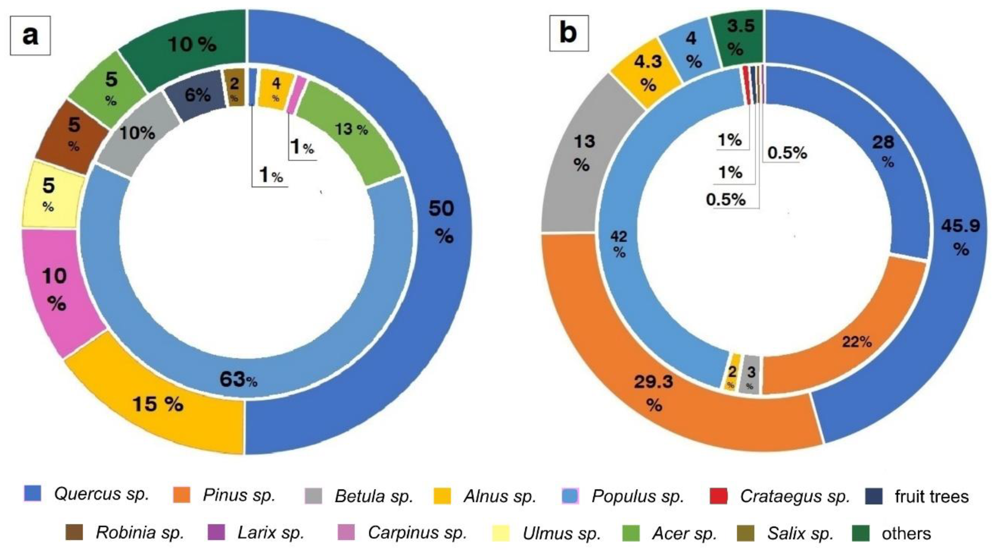
5.1. Characteristic of Trees in High Structural Diversity Tree Map

The Bielański Forest consists of 12,346 trees. The most frequent taxa are Quercus, Alnus, Carpinus, Ulmus, Robinia, and Acer. Less common taxa include Pinus, Betula, Populus, Fraxinus, Aesculus, Salix, and fruit trees, e.g., Malus, Pyrus, or Prunus. The oldest tree in the reserves is a Quercus, with an age of 400 years.
In the Bielański Forest, out of a total of 12,227 trees, only 83 trees (0.7%) were defoliated trees indicated on the map as ill trees with a range of 65–100% defoliation shown in the High Structural Diversity Tree Crown Map for Warsaw (Figure 3a). Other defoliated trees were Populus, Acer, Betula, Alnus, Salix, Carpinus, and fruit trees, e.g., Malus, Prunus, and Pyrus.
The Kabacki Forest consists of 228,734 trees. The most frequent taxa are Quercus, Pinus, Betula, Alnus, and Populus. Less common trees were Robinia, Carpinus, Larix, Fraxinus, Ulmus, Crataegus and fruit trees, e.g., Malus and Prunus.
Out of a total of 228,734 trees in the Kabacki Forest, only 264 trees (0.2%) were indicated on the map as ill trees with a range of 65–100% defoliation shown in the High Structural Diversity Tree Crown Map for Warsaw. Some trees such as the old specimens of Quercus (with an age of 300 years on average) and younger specimens of trees aged about 100 years and below, were short-lived specimens with brittle wood characterization: Pinus sp. and Populus sp., which are dominant trees. The remaining species of defoliated trees were: Betula, Alnus, Crataegus, Robinia, Larix, and fruit trees, e.g., Malus, Pyrus, and Prunus. The compilation of trees of both forest sites is presented in Table 1 and Figure 3a,b.

5.2. Field Observation of Defoliated Trees from ALS Data

Field analysis of a total of 345 defoliated trees in both forests selected using the ALS method (range 65–100% defoliation) indicated their health characteristics (Tables S1 and S2). A summary of the poor health condition of the defoliated trees is presented in Table A1, Table A2 and Table A3 (Appendix A) and Figure 4 and Figure 5. Based on these data, 16 features of poor health condition of trees were observed: These features and their description are illustrated in Table 2.
Among these 16 characteristics, feature 1 (broken or dry falling branches) was the most noticeable in both forests (Figure 4A,D,E, and Figure 5E). These features were most evident in the following tree species: Acer, Quercus, and Populus. Due to the nature of forests as reserves, no attempt was made to care for them. Features 2–16 were less noticeable, mainly due to sanitary cuts made in connection with difficult recreation in more representative parts of both forests (Figure 4B,C and Figure 5B–F). These features were most evident in the following tree species: Populus, Quercus, Pinus, and Betula. Based on our field observations, it appears that features 1 and 13 (trunk intersection) were especially dangerous. They were inclined adjacent to the forest paths, posing a threat to forest safety and recreation (Figure 4A,D,E and Figure 5B,F). These features were most evident in the following tree species: Acer, Populus, and Quercus.
As presented in Table A1, Table A2 and Table A3 (Appendix A), 59 trees (71% of all defoliated trees) were observed in the Bielański Forest, and 125 trees (48% of defoliated trees) were affected by Storm Eunice because of fractures caused by poor health due to broken branches (feature 1, Figure 4A,D,E and Figure 5C,F), conductor broken off (feature 4, Figure 5B), cracks of the trunk (feature 5), split at the base of the trunk (feature 10, Figure 5A,B), and tree torn from the ground (feature 15, Figure 5D).
The distribution of individual tree species of defoliated trees in the Bielański Forest and the Kabacki Forest is illustrated on maps (Figure 6 and Figure 7). In addition, trees that were near pedestrian and bicycle paths that posed a direct threat to visitors are indicated by red rings (Figure 8 and Figure 9). A total of 25 such trees (30.1% of defoliated trees) were observed in the Bielański Forest, and 66 trees (25.2% of defoliated trees) were observed in the Kabacki Forest.

5.3. Hazard Maps for Urban Forests

Based on the location of defoliated trees and their characteristics, threat maps were created for both forests. In this map, zones with ill trees that pose a threat to recreation and require monitoring were indicated (Figure 8 and Figure 9) by the local authorities, and the dangerous parts of both sites were restricted to residents.
As illustrated in Figure 8 and Figure 9, around each defoliated tree marked on the map, a hazard zone was created. The range of the hazard zone was calculated in both forests based on the average height of the trees (height average—14.7 m—multiplied by 2 from the center of a given defoliated tree shown on maps). Thus, the average distance for each zone was 29.7 m (a rounded value of 30 m was used), which is a safe distance that should be maintained when securing defoliated trees and separating danger zones.
The location of endangered trees obtained using ALS can determine the range of hazard zones of a given forest area. Examples of such dangers may be shown on maps and smartphone applications (Figure 10) [81]. It is worth noting that such practical applications of urban green infrastructure elements seem to be more popular and are already being tested by researchers, including the development of tourist routes in forests, e.g., Endomondo, MapIT, mLas, tMap or Gpies.com, and tree information systems in urban green spaces in cities, in which the residents themselves are involved [82,83,84,85]. This way, in determining the fate of trees, a map of risk zones in forests seems to be a useful instrument in informing the local community about spatial barriers and security threats in forests.
Finally, analysis of the High Structural Diversity Tree Crown Map for both forests showed that trees in nature reserves are mostly in good condition, and only 345 trees selected as having 65–100% defoliation using ALS (0.1% of all forest trees) are ill trees in both forests. However, they pose threats to visitors, and action must be taken to secure them for recreation and to ensure safety in forests. It is especially necessary to secure leaning and broken trees nearby pedestrian and bike paths to avoid endangering visitors.

6. Discussion

6.1. Remote Sensing for Old Growth Forests

Remote sensing data and tools can be beneficial for a wide range of tasks around urban green infrastructure management [38]. As this article shows, this can also be applied in biodiverse old-growth forest stands where differing ecosystem services must be balanced. These services encompass habitat provisioning and recreational functions in particular. However, the state and diversity of Polish urban forests are mainly measured by the usage of traditional methods of land inventory [31,32]. As this is a time-consuming method, inventories through remote sensing methods like LiDAR can accelerate the gathering of information on the state of urban forests, e.g., in time-critical moments around major storms or after hot droughts [57].
Besides elaborate airborne products, in Poland, the height and location of trees can be also analyzed based on satellite data available on Tree Crown Map (pl. “Mapa koron drzew”)/National Tree Crown Map (pl. “Krajowa mapa koron drzew”) [67,86,87]. In the case of Warsaw, it is possible to analyze wider parameters of greenery, i.e., their distribution height, species composition, and health condition (leaf defoliation sensor) based on aerial data (ALS). The ALS map presents only the trees within the city of Warsaw [66,78,81] and currently has no wider comparative application against the background of similar cities in Poland. However, it is a valuable source of up-to-date knowledge about trees in the city and their parameters, including tree health, which can serve as guidelines for further maintenance orders and administrative decisions. At present, unfortunately, there is little research that discusses this given issue more extensively, for instance there is no study that uses the acquired ALS data for Warsaw, for environmental monitoring purposes. The local authorities of Warsaw city however began to implement RS solutions in inventorying, monitoring, and management of urban greenery throughout the administered city area [26,27,28,29]. Therefore, supportive research on the matters is important and timely.
It is worth noting that the High Structural Diversity Tree Crown Map for Warsaw may find a new application as an example of ALS in detecting the poor health condition of trees to study detailed characteristics of defoliated trees in the fields of urban ecology, forestry, dendrology, and landscape architecture [26,56,87,88,89,90,91,92,93]. In this direction, there is current research in large cities such as Wrocław, Kraków or Poznań within the framework of the LIFE project (LIFECOOLCITY) funded by the European Commission. The main objective is to increase the adaptive capacity of at least 10,000 EU cities by implementing two innovative RS systems to manage blue-green infrastructure [89,90].
It is worth noting that LiDAR data could classify both the overstory and dominant understory species and thus play a crucial role in identifying forest biodiversity. This approach will be useful for forestry, landscape architecture, and urban ecology to plan for sustainable urban forests, rich in biodiversity, and produce interactive maps for monitoring species of interest used by local authorities like city councils or interested citizens).
The trade-offs between visitor safety and biodiversity protection in forests can be reduced through education programs for forest managers and residents that can be based on ALS monitoring data. Of significant importance are educational activities, guidelines for managers on what actions should be taken in forest areas with intensive recreation. Further, training of staff in the application of computer techniques, and the current knowledge base of trees in GIS platforms (LiDAR and ALS, e.g., High Structural Diversity Tree Crown Map) is seen as beneficial. Applications about forests, recreation, and natural resources (providing information about spatial zoning, mosaics of management intensity, favoring more resistant species next to paths, etc.) can be helpful for residents, which are clear options for balancing safety and biodiversity [81,82,83,84,85,91,93].

6.2. Management Suggestions

Storm Eunice in 2022 damaged over half of the defoliated trees keeping much of the storm’s damages in comparatively confined areas. Still, one of the forests was completely closed to visitors and in the other forest, areas with damaged trees were fenced off, and the remaining branches and fallen trees were removed to make the forest areas available as soon as possible for recreation, which is not necessarily the best option for biodiversity conservation. Therefore, based on our evidence, we suggest more nuanced and targeted forms of management of the reserves to mitigate trade-offs between visitor safety and biodiversity benefits.
Buffer paths. A system of protective paths for recreation with a safety distance of 50 m from the edge of the road is suggested. Such a solution will ensure a safe distance for the pedestrian from ill trees with amplified risks of falling. The distance of 50 m was an average value considering the height of trees in the forest determined using ALS (Tables S1 and S2).
Buffer defoliated trees. The use of protection zones around the defoliated trees is also suggested in this study. Trees with the worst state in health should be mechanically secured, e.g., supports, and should be undercut with dried or broken branches (or nets reinforcing the tree trunk in the case of trees with breaks). A circular zone of 30 m around these trees should be required to separate this place from the access of pedestrians and cyclists. This will ensure a safe distance between individuals and the ill tree with the risk of falling. The distance of 50 m was an average value considering the height of trees in the forest determined using a table of attributes with data on defoliated trees using ALS (Tables S1 and S2). These zones are shown in Figure 8 and Figure 9.
Tree species that are more affected. This study indicates that it is necessary to protect tree species from defoliated trees that are particularly susceptible to breaks or dry or falling branches, such as Betula, Alnus, Acer, Pinus, Larix, and over 300-year-old Quercus sp. These trees had a shallow root system or brittle wood prone to damage and fractures, as illustrated in Figure 4 and Figure 5. These trees should be secured with ropes to the ground or with supports that prevent the branches from falling. Furthermore, these trees can be cut down in sensitive places, e.g., in rest areas or near pedestrian walking or cycling roads, as their health is poor, or they are old and prone to breakage. Special attention should also be paid to old oak species (Quercus) with numerous fractures or cracks. They need to be fenced off from the visitor access space or supported by special supports and nets strengthening the trunk and root system to minimize the risk of falling heavy branches on fences or walking/driving trails. Forest managers need to observe these trees and provide their expert opinion. This way, forest tree monitoring can lead to constant monitoring, stabilization, adaptation to removal, and reducing the risk of danger to individuals visiting these sites.
Visitor Information. We propose to develop a GIS-based forest information system. First, initial information about the condition of trees and their health status and threats can be given and made accessible on the basis of QR code technology. A forest visitor with a smartphone can scan the code, which will redirect the person to information about applications and thematic maps showing threats (hazard maps) and possibilities and limitations of recreation in the forest. Moreover, those interactive maps may inform visitors about the value an old-growth forest has, and very much the fact that in case of a storm, it is not a safe place. Such information may be also distributed via GIS applications (e.g., Endomondo, MapIT, mLas, tMap, or Gpies.com), which are currently available and become increasingly more widespread among forest visitors in Poland.
Visitor management. The results of field analyzes using LiDAR technology can provide a range of information to forest managers. They can also be helpful in managing forest trees, as well as in determining core and buffer areas where dead branches and risks are allowed. Such areas can be very quickly demarcated from the recreation area, which can increase the level of safety of forest visitors.
The implementation of a green infrastructure map service in the capital city of Poland. Currently, there is a growing demand for ecological monitoring of forest in Poland, e.g., the Forest Data Bank (pl. Bank danych o lasach) and the Large Area Forest Inventory (pl. Wielkoobszarowa Inwentaryzacja Stanu Lasu). This information is collected based on continuous or periodic observations of forest land use. Reports prepared by research institutes (pl. Instytut Badwczy Leśnictwa) on behalf of the General Directorate of Forests (pl. Generalna Dyrekcja Lasów Państwoych) can be used as a comprehensive source of the health status of forests However, while increasingly more data is available it seems that appropriate forms of portraying and communicating it are not yet available. As data portals and interactive maps have potential to promote sustainable development around urban green infrastructure this is unfortunate [13]. For instance, the data presentation on the portal of the municipality of Warsaw, defoliation and species related information are shown in separate views that cannot easily be brought together [26,65,66,78]. In addition, the integration of RS specialists to analyze and interpret the available data prevents practical application of the developed High Structural Diversity Tree Crown Map in the management and protection of valuable trees. On a positive note, since March 2020, the local authorities of Warsaw city have made a map service available about Warsaw’s greenery, which is the result of the LIFE project [89,90]. The goals of this project are also based on the implementation of technology on the level of green infrastructure management and social participation through iterative provision of the map service, towards the ideal of a smart city.
Remote sensing allows to obtain spatially detailed and temporally continuous information for trees and shrubs in a large area in a short time (several months) regarding the extent of crowns, occupied area, height, taxonomic differentiation, and health condition. These data can be successfully used in functional and spatial analyzes in the field of, e.g., site planning and selection of tree and shrub species for new plantings, shaping the structure of tall greenery in individual districts, valuing, and estimating the scale of ecosystem services provided by tall greenery, but also allocating land for construction projects or planning the location of infrastructure, as well as environmental monitoring [26,27,28,29,85,89,90].

6.3. Analysis and Prediction of Hazards Using LiDAR Methods

Biodiversity and tree crown mapping is important in the context of climate change and increasingly strong storms. It should be emphasized that the activities based on spatial LiDAR data listed in this pilot study may also have new applications, especially regarding weather anomalies in Europe, such as unexpected short storms, intense rains, and drought [34,69,70]. The access to information about urban recreation areas should be up to date and available to visitors as soon as possible [13].
Furthermore, results of this study show that both old trees (stately oaks) and younger short-lived ones (species with poor wood compactness like ash, or pines) may pose threats to visitors, which is confirmed by many years of research by Siewniak and Bobek [25] in historical parks in cities of Poland. The High Structural Diversity Tree Crown Map for Warsaw, as an example of ALS, may find new applications in the diagnosis of safety threats, as it also contains information on species composition. Similar ALS databases have already been commissioned by other cities in Poland, e.g., Wrocław. Within the framework of the LIFE project, the authors assume that within the next dozen years, a similar green inventory will be carried out using analogical parameters as in Warsaw [26,27,28,29,89,90]. Furthermore, it is possible to estimate the amount of carbon dioxide absorbed by trees, oxygen production, or urban heat island formation, which facilitates adaptation to climate change. It is envisioned that residents have the possibility to receive comprehensive and up-to-date information about the state of urban greenery. Towards this The High Structural Diversity Tree Crown Map is an important solution that can be used by other local authorities in polish cities, as well as by landscape architects, ecologists, foresters, and scientists [26,27,28,29,34,35,36,89,91,92,94,95].

7. Conclusions

The research methods used in this study show a new application of remote sensing-derived maps in evaluating trees in cities, not only as common elements of urban green infrastructure such as parks or tree avenues but also as nature protection areas with old trees. This method can be useful for local authorities in identifying trees that need treatment or removal, protecting neighboring areas from material damage and human health in the case of weather anomalies such as windbreaks. This way, LiDAR scanning can guide tree care treatments in urban forest reserves, where recreation pressure is high.
In both forests, site observations indicated that more than half (59.5%) of the defoliated trees identified in the High Structural Diversity Crown Map for Warsaw were destroyed or damaged in Storm Eunice in 2022. This was validated in field research organized as workshops.
ALS can be useful in the monitoring of forested areas in cities and other areas of urban green infrastructure. These results allow local authorities to find trees in the Bielański Forest and the Kabacki Forest that should be diagnosed and secured immediately in the context of forest recreation or change the visitor management or information system accordingly to steer people away from potentially dangerous locations.
This study presents guidelines and tools for detailed information on how and where such rerouting of visitors is most needed. These are hazard maps with information on endangered trees, protective paths for recreation with a safe strip and protection zones around the defoliated trees. This way forest tree monitoring can reduce the risk of danger to individuals visiting these sites.
The location of endangered trees obtained using ALS should be used to disseminate information via private and public web-GIS platforms and smartphone Apps that control leisure traffic in recreational forest areas. New applications for urban forests that will allow residents to recognize trees and download the current information about forest safety and the health condition of trees need to be developed. This way, visitors can be made aware of the need of old-grown trees and areas that are less accessible to them, helping forest managers in public relations around biodiversity conservation.
The findings of this study emphasize that it is not possible to achieve maximal ecosystem services for both biodiversity and recreation potential in an old-grown forest reserve. Much rather, a good practice would be to balance trade-offs between visitor safety and biodiversity protection mentioned above. Critical in this regard is the localized evaluation and involvement of residents as such decisions are very much context dependent that are partially beyond the eyes of a remote sensing sensor. In conclusion, specialized sensing techniques made actionable are beneficial assets in current urban governance aiming towards healthy, biodiverse, green, and smart cities.

Supplementary Materials

The following supporting information can be downloaded at: https://www.mdpi.com/article/10.3390/land12020275/s1, The article contains additional material constituting a database (High Structural Diversity Tree Crown Map). The material is presented in Tables S1 and S2.

Author Contributions

Conceptualization, A.D., T.W. and D.H.; methodology, A.D., T.W. and D.H.; software, A.D.; validation, A.D., T.W. and D.H.; formal analysis, A.D. and T.W.; investigation, A.D.; resources, A.D.; data curation, A.D.; writing—original draft preparation, A.D.; writing—review and editing, A.D., T.W. and D.H.; visualization, A.D.; supervision, D.H.; project administration, A.D.; funding acquisition, A.D. All authors have read and agreed to the published version of the manuscript.

Funding

This research was developed within the project BiNatUr: Bringing nature back—biodiversity-friendly nature-based solutions in cities and funded through the 2020–2021 Biodiversa and Water JPI joint call for research projects, under the BiodivRestore ERA-NET Cofund (GA N°101003777), with the EU and the funding organisations Academy of Finland (Finland), Bundesministerium für Bildung und Forschung (BMBF, Germany), Federal Ministry of Education and Research (Germany), National Science Centre (Poland), Research Foundation Flanders (fwo, Belgium) and Fundação para a Ciência e Tecnologia (Portugal). Dagmar Haase works in The CLEARING HOUSE project, which has received funding from the European H2020 Research and Innovation programme under the Grant Agreement n◦ 821242. The content of this document reflects only the author’s view. The European Commission is not responsible for any use that may be made of the information it contains.

Institutional Review Board Statement

Not applicable.

Informed Consent Statement

Not applicable.

Data Availability Statement

The database for the High Structural Diversity Map is synthetically discussed in the article. The data is made available to the authors of the given article by Urząd m.st. Warszawy (The city council of Warsaw city, Poland) in their letter (No. BG-IIP.6642.24.2020.LZG, OŚ-I.604.457.2022.AMA) regarding the availability of the resource in connection with the submission of this paper for publication in the special issue of MDPI Land.

Acknowledgments

We thank Zastępca Prezydenta miasta stołecznego Warszawy; Naczelnik wydziału, from Biuro Geodezji I Katastru Wydział Infrastruktury Informacji Przestrzennej Urząd m.st. Warszawy, Zastępca Dyrektora Biuro Ochrony Środowiska Urząd m.st. Warszawy, and Główny specjalista, from Biuro Ochrony Środowiska (OŚ) Wydział Strategii i Informacji o Środowisku Urząd m.st. Warszawy, for sharing the High Structural Diversity Map database. The authors would like to thank the students and interdisciplinary team of researchers for participating in the workshops on the health of endangered trees in the Bielański and Kabacki forests. The authors would like to thank the reviewers for all useful and helpful comments on our manuscript.

Conflicts of Interest

The authors declare no conflict of interest.

Appendix A

Table A1. Selected defoliated trees of poor health condition (features 1–6) in the Bielański Forest and the Kabacki Forest in Warsaw city.
Feature 1 Feature 2 Feature 3
Broken or dry
branches
Roots groving around
the trunk
Tree inclined adjecent
to the path
Bielański ForestKabacki Forest Bielański ForestKabacki Forest Bielański ForestKabacki Forest
Acer10 Acer3 Acer2
Alnus22Alnus31Alnus1
Betula43Betula12Betula
Carpinus2 Carpinus Carpinus
fruit trees12fruit trees fruit trees1
Populus2443Populus41Populus84
Salix2 Salix Salix
Quercus125Quercus 3Quercus 3
Crataegus Crataegus Crataegus
Larix Larix Larix
Pinus 17Pinus 7Pinus 2
total4594total1114total129
1392521
feature 4 feature 5 feature 6
Conductor
broken off
Cracks on
the trunk
A decayed
tree
Bielański ForestKabacki Forest Bielański ForestKabacki Forest Bielański ForestKabacki Forest
Acer Acer Acer
Alnus Alnus Alnus
Betula2 Betula1 Betula1
Carpinus Carpinus Carpinus
fruit trees fruit trees1 fruit trees1
Populus21Populus18Populus18
Salix Salix Salix
Quercus. 4Quercus17Quercus17
Crataegus Crataegus Crataegus
Larix Larix 1Larix 1
Pinus Pinus Pinus
total88total45total416
16920
Table A2. Selected defoliated trees of poor health condition (features 7–12) in the Bielański Forest and the Kabacki Forest in Warsaw city.
Feature 7 Feature 8 Feature 9
A rickety tree Decayed hallows dry tree
Bielański ForestKabacki Forest Bielański ForestKabacki Forest Bielański ForestKabacki Forest
Acer Acer Acer
Alnus 1Alnus Alnus
Betula1 Betula Betula 1
Carpinus Carpinus Carpinus
fruit trees fruit trees1 fruit trees1
Populus66Populus11Populus72
Salix Salix Salix1
Quercus 2Quercus Quercus 5
Crataegus Crataegus Crataegus
Larix Larix Larix
Pinus 10Pinus Pinus 2
total719total21total911
26320
feature 10 feature 11 feature 12
Split at the base of the trunk Slightly bent tree A thinning tree
Bielański ForestKabacki Forest Bielański ForestKabacki Forest Bielański ForestKabacki Forest
Acer Acer Acer
Alnus Alnus Alnus
Betula Betula Betula
Carpinus Carpinus s Carpinus
fruit trees fruit trees fruit trees
Populus11Populus32Populus 7
Salix Salix Salix
Quercus.11Quercus Quercus 3
Crataegus Crataegus Crataegus
Larix Larix Larix
Pinus 3Pinus Pinus 1
total24total32total011
6511
Table A3. Selected defoliated trees of poor health condition (features 13–16) in the Bielański Forest and the Kabacki Forest in Warsaw city.
Feature 13 Feature 14 Feature 15
Trunks intersect with each others A bulky growth on the trunk Tree torn from the ground
Bielański ForestKabacki Forest Bielański ForestKabacki Forest Bielański ForestKabacki Forest
Acer Acer Acer
Alnus Alnus 1Alnus
Betula Betula 1Betula 1
Carpinus Carpinus Carpinus
fruit trees fruit trees fruit trees
Populus12Populus Populus36
Salix1 Salix Salix
Quercus 1Quercus 2Quercus 2
Crataegus Crataegus Crataegus
Larix Larix Larix
Pinus Pinus 1Pinus 5
total23total05total014
5514
feature 16
Signs of desease, partially dry needles or leaves
Bielański ForestKabacki Forest
Acer
Alnus
Betula
Carpinus
fruit trees
Populus122
Salix1
Quercus. 10
Crataegus
Larix
Pinus 7
total239
39

References

  1. Ajewole, O.I.; Aiyeloja, A.A. Socio-economic analysis of benefits of Ibadan Urban Forest Reserves. J. Trop. For. Res. 2004, 20, 95–105. [Google Scholar]
  2. Fleming, C.M.; Manning, M.; Ambrey, C.L. Crime, greenspace and life satisfaction: An evaluation of the New Zealand experience. Landsc. Urban Plan. 2016, 149, 1–10. [Google Scholar] [CrossRef]
  3. Kabisch, N.; van den Bosch, M.; Lafortezza, R. The health benefits on nature-based solutions to urbanization hallenges for children and erderly—A systematic review. Environ. Res. 2017, 159, 362–373. [Google Scholar] [CrossRef]
  4. Haase, D.; Hellwig, R. Effects of heart and drought stress on the health status of six urban street tree species in Leipzig, Germany. Trees For. People 2022, 8, 100252. [Google Scholar] [CrossRef]
  5. Kičić, M.; Haase, D.; Marin, A.M.; Vuletić, D.; Ostoić, S.J. Perceptions of cultural ecosystem services of tree-based green infrastructure: A focus group participatory mapping in Zagreb, Croatia. Urban For. Urban Green. 2021, 78, 127767. [Google Scholar] [CrossRef]
  6. Webb, R. Learning from Urban Forestry Programmes in South East Asia. Arboric. J. 1999, 23, 39–56. [Google Scholar] [CrossRef]
  7. Kowarik, I.; Hiller, A.; Planchuelo, G.; Seitz, B.; von der Lippe, M.; Buchholz, S. Emerging Urban Forests: Opportunities for Promoting the Wild Side of the Urban Green Infrastructure. Sustainability 2019, 11, 6318. [Google Scholar] [CrossRef] [Green Version]
  8. Steenberg, J.W.N.; Duinker, P.N.; Charles, J.D. The neighbourhood approach to urban forest management: The case of Halifax, Canada. Landsc. Urban Plan. 2013, 117, 135–144. [Google Scholar] [CrossRef]
  9. Troy, A.; Grove, J.M.; O’Neil-Dunne, J. The relationship between tree canopy and crime rates across an urban–rural gradient in the greater Baltimore region. Landsc. Urban Plan. 2012, 106, 262–270. [Google Scholar] [CrossRef]
  10. Ulrich, R.S.; Simons, R.F.; Losito, B.D.; Fiorito, E.; Miles, M.A.; Zelson, M. Stress recovery during exposure to natural and urban environments. J. Environ. Psychol. 1991, 11, 201–230. [Google Scholar] [CrossRef]
  11. Bolund, P.; Hunhammar, S. Ecosystem Services in Urban Areas. Ecol. Econ. 1999, 29, 293–301. [Google Scholar] [CrossRef]
  12. Almenar, J.B.; Elliot, T.; Rugani, B.; Philippe, B.; Gutierrez, T.N.; Sonnemann, G.; Geneletti, D. Nexus between nature-based solutions, ecosystem services and urban challenges. Land Use Policy 2021, 100, 104898. [Google Scholar] [CrossRef]
  13. Wellmann, T.; Andersson, E.; Knapp, S.; Lausch, A.; Palliwoda, J.; Priess, J.; Scheuer, S.; Haase, D. Reinforcing nature-based solutions through tools providing so-cial-ecological-technological integration. Ambio 2022. [Google Scholar] [CrossRef]
  14. Marselle, M.R.; Bowler, D.; Watzema, E.J.; Eichenberg, D.; Kirsten, T.; Bonn, A. Urban street tree biodiversity and antidepressant prescriptions. Sci. Rep. 2020, 10, 1–11. [Google Scholar]
  15. Baumeister, C.F.; Gerstenberg, T.; Plieninger, T.; Schraml, U. Exploring cultural ecosystem services hotspots: Linking multiple urban forest features with public participation mapping data. Urban For. Urban Green. 2020, 48, 126561. [Google Scholar] [CrossRef]
  16. Jim, C.Y.; Chen, W.Y. Ecosystem services and valuation of urban forests in China. Cities 2009, 26, 187–194. [Google Scholar] [CrossRef]
  17. Schafer, C.S.; Scott, D.; Baker, J.; Winemiller, K. Recreation and Amenity Values of Urban Stream Corridors: Implications for Green Infrastructure. J. Urban Des. 2013, 18, 478–493. [Google Scholar] [CrossRef]
  18. Fornal-Pieniak, B.; Żarska, B.; Zaraś-Januszkiewicz, E. Natural evaluation of landscape in urban area comprising Bielański Forest nature reserve and surroundings, Warsaw, Poland. Directions for landscape protection and planning. Ann. Warsaw Univ. of Life Sci.-SGGW Land Reclam. 2018, 50, 327–338. [Google Scholar] [CrossRef]
  19. Alvey, A.A. Promoting and preserving biodiversity in the urban forest. Urban For. Urban Green. 2006, 5, 195–201. [Google Scholar] [CrossRef]
  20. Długoński, A. Wykorzystanie Mapy Koron Drzew do oceny stanu zdrowotności drzewostanu rezerwatów miejskich. Przykład Lasu Bielańskiego w Warszawie [The use of the High Structural Diversity Tree Crown Map to assess the health status of forest trees in urban reserves. An example of the Bielański Forest in Warsaw]. In Proceedings of the V Edycja Konferencji Środowisko Informacji, Ministerstwo Klimatu Środowiska, Warsaw, Poland, 25 November 2021. [Google Scholar]
  21. Ordónez, C.; Duinker, P.N.; Steenberg, J.W.N. Climate change mitigation and adaptation in urban forests: A framework for sustainable urban forest management. In Proceedings of the 18th Commonwealth Forestry Conference, Edinburgh, UK, 28 June–2 July 2010. [Google Scholar]
  22. Haase, D.; Annegret Haase, A.; Wolff, M.; Dushkova, D. (Eds.) Nature-Based Solutions (NBS) in Cities and Their Interaction with Urban Land, Ecosysems, Built Environment and People: Debating Societal Implications, 1st ed.; MDPI Land: Beijing, China, 2021; pp. 1–216. [Google Scholar]
  23. Konijnendijk, C.C.; Nilsson, K.; Randrup, T.B.; Schipperijn, J. Urban forestry education. In Urban Forests and Trees, 1st ed.; Konijnendijk, C.C., Randrup, T.B., Eds.; Springer: Berlin, Germany, 2005; Volume 1, pp. 465–478. [Google Scholar]
  24. Nowak, D.J.; Noble, M.H.; Sisinni, S.M.; Dwyer, J.F. Assessing the US urban forest resource. J. For. 2001, 99, 37–42. [Google Scholar]
  25. Siewniak, M.; Bobek, W. Zagrożenia ludzi i mienia w parkach, metody określania stanu statycznego drzew. [Threats to people and property in parks, methods of determining the static state of trees]. Kur. Konserw. 2010, 8, 13–17. (In Polish) [Google Scholar]
  26. Webinarium Mapa Koron Drzew w Zarządzaniu Zielenią Wysoką w Mieście. Prykład Wdrożenia w Mieście. Przykład Wdrożenia w m.st. Warszawa [Webinar Tree Crown Map in the Management of Tall Greenery in the City. An Example of Implementation in the City. Example of Implementation in Warsaw], 29 October 2020, MGGP Aero. Available online: https://www.youtube.com/watch?v=S7HOlA7hDRg (accessed on 3 January 2022).
  27. Wylazłowska, J.; Sławik, Ł.; Kopeć, D. Teledetekcja nowe perspektywy w zarządzaniu zielenią. Zieleń Miejska 2000, 5, 38–39. [Google Scholar]
  28. Wronka, M. Warszawska Mapa Koron Drzew. Zieleń Miejska 2019, 2, 15–16. [Google Scholar]
  29. Sławik, Ł.; Kopeć, D. Mapa koron drzew w zarządzaniu zielenią wysoką w mieście. Zieleń Miejska 2020, 10, 28–31. [Google Scholar]
  30. Laurin, G.V.; Chan, J.C.W.; Chen, Q.; Lindsell, J.A.; Coomes, D.A.; Guerriero, L.; del Frate, F.; Miglietta, F.; Valentini, R. Biodiversity mapping in a tropical West African forest with airborne hyperspectral data. PLoS ONE 2014, 9, e97910. [Google Scholar]
  31. Łukaszkiewicz, J.; Fortuna-Antoszkiewicz, B.; Borowski, J. The impact of earthworks on older trees in historical parks. J. Environ. Eng. Landsc. Manag. 2011, 30, 188–194. [Google Scholar] [CrossRef]
  32. Rosłon-Szeryńska, E.; Łukaszkiewicz, J.; Fortuna-Antoszkiewicz, B. The possibility of predicting the collision of trees with construction investments. VI International Conference of Science and Technology INFRAEKO 2018 Modern Cities. Infrastruct. Environ. 2018, 45, 00076. [Google Scholar]
  33. Bergen, K.M.; Goetz, S.J.; Dubayah, R.O.; Henebry, G.M.; Hunsaker, C.T.; Imhoff, M.L.; Nelson, R.F.; Parker, G.G.; Radeloff, V.C. Remote sensing of vegetation 3-D structure for biodiversity and habitat: Review and implications for lidar and radar spaceborne missions. J. Geophys. Res. Biogeosci. 2009, 114, G22009. [Google Scholar] [CrossRef] [Green Version]
  34. Lin, B.; Ossola, A.; Ripple, W.; Alberti, M.; Andersson, E.; Bai, X.; Dobbs, C.; Elmqvist, T.; Evans, K.L.; Frantzeskaki, N.; et al. Cities and the “new climate normal”: Ways forward to address the growing climate challenge. Lancet Planet. Health 2021, 5, e479–e486. Available online: http://www.thelancet.com/planetary-health (accessed on 30 July 2022).
  35. Żarska, B.; Fornal-Pieniak, B.; Zaraś-Januszkiewicz, E. Areas designed for afforestation and areas excluded from afforestation- selected aspects related to the protection of the landscape in view of Poland experience. Ecol. Quest. 2015, 22, 17–22. [Google Scholar]
  36. Fornal-Pieniak, B.; Długoński, A. Urban landscape assessment for tourism aspect in a big-sized city in Poland (Example of Łódź city, Central Poland–- preliminary study). In Proceedings of the XXVII Conference in the Series of Garden Art and Historical Dendrology, IX International Edition: Urban Ecology and Cultural Heritage in the City, Kraków, Poland, 22–23 October 2020. [Google Scholar]
  37. Wellmann, T.; Lausch, A.; Andersson, E.; Knapp, S.; Cortinovis, C.; Jache, J.; Scheuer, S.; Kremer, P.; Mascarenhas, A.; Kraemer, R.; et al. Remote sensing in urban planning: Contributions towards ecologically sound policies? Landsc. Urban Plan. 2020, 204, 103921. [Google Scholar] [CrossRef]
  38. Afzalan, N.; Muller, B. The role of social media in green infrastructure planning: A case study of neighborhood participation in park siting. J. Urban Technol. 2014, 21, 67–83. [Google Scholar] [CrossRef]
  39. Grêt-Regamey, A.; Switalski, M.; Fagerholm, N.; Korpilo, S.; Juhola, S.; Kyttä, M.; Käyhkö, N.; McPhearson, T.; Nollert, M.; Rinne, T.; et al. Harnessing sensing systems towards urban sustainability transformation. Npj Urban Sustain. 2021, 1, 1–9. [Google Scholar] [CrossRef]
  40. Kamoske, A.G.; Dahlin, K.M.; Read, Q.D.; Record, S.; Stark, S.C.; Serbin, S.P.; Zarnetske, P.L. Towards mapping biodiversity from above: Can fusing lidar and hyperspectral remote sensing predict taxonomic, functional, and phylogenetic tree diversity in temperate forests? Glob. Ecol. Biogeogr. 2022, 31, 1239–1465. [Google Scholar] [CrossRef]
  41. Nagendra, H. Using remote sensing to assess biodiversity. Int. J. Remote Sens. 2001, 22, 2377–2400. [Google Scholar] [CrossRef]
  42. Anderson, C.B. Biodiversity monitoring, earth observations and the ecology of scale. Ecol. Lett. 2018, 21, 1572–1585. [Google Scholar] [CrossRef]
  43. Schäfer, E.; Heiskanen, J.; Heikinheimo, V.; Pellikka, P. Mapping tree species diversity of a tropical montane forest by unsupervised clustering of airborne imaging spectroscopy data. Ecol. Indic. 2016, 64, 49–58. [Google Scholar] [CrossRef]
  44. Wardhana, W.; Widyatmanti, W.; Soraya, E.; Soeprijadi, D.; Larasati, B.; Umarhadi, D.A.; Hutomo, Y.H.T.; Idris, F.; Wirabuana, P.Y.A.P. A hybrid approach of remote sensing for mapping vegetation biodiversity in a tropical rainforest. Biodiversitas 2020, 21, 3946–3953. [Google Scholar] [CrossRef]
  45. Kampouri, M.; Kolokoussis, P.; Argiala, D.; Karathanassi, V. Mapping of forest tree distribution and estimation of forest biodiversity using Sentinel-2 imagery in the University Research Forest Taxiarchis in Chalkidiki, Greece. Geocarto Int. 2019, 34, 1273–1285. [Google Scholar] [CrossRef]
  46. Bagaram, B.M.; Giuliarelli, D.; Chirici, G.; Giannetti, F.; Barbati, A. UAV remote sensing for biodiversity monitoring: Are forest canopy gaps good covariates? Remote Sens. 2018, 10, 1397. [Google Scholar] [CrossRef]
  47. Colgan, M.S.; Baldeck, C.A.; Féret, J.-B.; Asner, G.P. Mapping savanna tree species at ecosystem scales using support vector machine classification and BRDF correction on airborne hyperspectral and LiDAR data. Remote Sens. 2012, 4, 3462–3480. [Google Scholar] [CrossRef]
  48. Dees, M.; Straub, C.; Koch, B. Can biodiversity study benefit from information on the vertical structure of forests? Utility of LiDAR remote sensing. Curr. Sci. 2012, 102, 1181–1187. [Google Scholar]
  49. Yadav, B.K.V.; Lucieer, A.; Baker, S.C.; Jordan, G.J. Tree crown segmentation and species classification in a wet eucalypt forest from airborne hyperspectral and LiDAR data. Int. J. Remote Sens. 2021, 42, 7952–7977. [Google Scholar] [CrossRef]
  50. Agarwal, S.; Vailshery, L.S.; Jaganmohan, M.; Harini Nagendra, H. Mapping urban tree species using very high resolution satellite imagery: Comparing pixel-based and object-based approaches. ISPRS Int. J. Geo-Inf. 2013, 2, 220–236. [Google Scholar] [CrossRef]
  51. Baldeck, C.A.; Asner, G.P.; Martin, R.E.; Anderson, C.B.; Knapp, D.E.; Kellner, J.R.; Wright, S.J. Operational tree species mapping in a diverse tropical forest with airborne imaging spectroscopy. PLoS ONE 2015, 10, e0118403. [Google Scholar] [CrossRef]
  52. Bunting, P.; Lucas, R.M.; Jones, K.; Bean, A.R. Characterisation and mapping of forest communities by clustering individual tree crowns. Remote Sens. Environ. 2010, 114, 2536–2547. [Google Scholar] [CrossRef]
  53. Feng, X.; Li, P. A tree species mapping method from UAV images over urban area using similarity in tree-crown object histograms. Remote Sens. 2019, 11, 1982. [Google Scholar] [CrossRef] [Green Version]
  54. Lee, A.C.; Lucas, R.S. A LiDAR-derived canopy density model for tree stem and crown mapping in Australian forests. Remote Sens. Environ. 2007, 111, 493–518. [Google Scholar] [CrossRef]
  55. Guo, X.; Coops, N.C.; Tompalski, P.; Nielsen, S.C.; Bater, C.W.; Stadt, J.J. Regional mapping of vegetation structure for biodiversity monitoring using airborne lidar data. Ecol. Inform. 2017, 38, 50–61. [Google Scholar] [CrossRef]
  56. Bartold, M. Development of forest cover mask to monitor the health condition of forests in Poland using long-term satellite observation. For. Res. Pap. 2016, 77, 141–150. [Google Scholar] [CrossRef] [Green Version]
  57. Długoński, A. Modern digital techniques used to record changes in the environment. In Microbial Biotechnology in the Laboratory and Practice Theory, Exercises and Specialist Laboratories, 1st ed.; Długoński, J., Ed.; Jagiellonian University Press: Łódź, Poland, 2021; Volume 1, pp. 124–133. [Google Scholar]
  58. Górski, F.; Łaskarzewska-Średzińska, M. (Eds.) Biocity Tom I [Biocity Volume 1], 1st ed.; Fundacja Wydziału Architektury Politechniki Warszawskiej NKA: Warsaw, Poland, 2015; pp. 1–56. [Google Scholar]
  59. Okła, K. Możliwości wykorzystania teledetekcji i fotogrametrii w Lasach Państwowych [Possibilities of using remote sensing and photogrammetry in State Forests]. In Geomatyka w Lasach Państwowych Część, I. Podstawy; Centrum Informacyjne Lasów Panstwoych: Bedoń, Poland, 2010; Volume 1, pp. 428–429. [Google Scholar]
  60. Karlson, M.; Reese, H.; Ostwald, M. Tree crown mapping in managed woodlands (parklands) of semi-arid West Africa using WorldView-2 imagery and geographic object based image analysis. Sensors 2014, 14, 22643–22669. [Google Scholar] [CrossRef] [Green Version]
  61. Levick, S.L.; Rogers, H.R. Structural biodiversity monitoring in savanna ecosystems: Integrating LiDAR and high resolution imagery through object-based image analysis. In Object-Based Image Analysis; Springer: Berlin/Heidelberg, Germany, 2008; pp. 477–491. [Google Scholar]
  62. Rappaport, D.I.; Royle, J.A.; Morton, D.C. Acoustic space occupancy: Combining ecoacoustics and lidar to model biodiversity variation and detection bias across heterogeneous landscapes. Ecol. Indic. 2020, 113, 106172. [Google Scholar] [CrossRef]
  63. Hastings, J.H.; Ollinger, S.V.; Ouimette, A.P.; Sanders-DeMott, T.; Palace, M.W.; Ducey, M.J.; Sullivan, F.B.; Basler, D.; Orwig, D.A. Tree species traits determine the success of LiDAR-based crown mapping in a mixed temperate forest. Remote Sens. 2020, 12, 309. [Google Scholar] [CrossRef] [Green Version]
  64. Alonzo, M.; Bookhagen, B.; Roberts, D.A. Urban tree species mapping using hyperspectral and lidar data fusion. Remote Sens. Environ. 2014, 148, 70–83. [Google Scholar] [CrossRef]
  65. Zakochaj się w Warszawie. Mapa Koron Drzew w Wersji Numerycznej dla Obszaru m.st. Warszawy [Map of Tree Crowns in Numerical Version for the Area of the Capital City of Warsaw]. Available online: https://danemiejskie.plarszawt/warszawska-mapa-koron-drzew/ (accessed on 20 December 2022).
  66. Millions of Warsaw’s Trees on One Map. Available online: https://en.um.warszawa.pl/-/millions-of-warsaw-s-trees-on-one-map (accessed on 3 January 2023).
  67. Krajowa Mapa Koron Drzew [National Tree Crown Map for Poland]. Available online: https://aplikacja.mapadrzew.com/ (accessed on 3 January 2023).
  68. GUS Informacja o Wynikach Narodowego Spisu Powszechnego Ludności i Mieszkań 2021 na Poziomie Województw, Powiatów i Gmin [ Eng. Information on the Results of the National Population and Housing Census 2021 at the Level of Voivodships, Powiats and Gminas]. Available online: https://stat.gov.pl/download/gfx/portalinformacyjny/pl/defaultaktualnosci/6494/8/1/1/informacja_o_wynikach_narodowego_spisu_powszechnego_ludnosci_i_mieszkan_20–09-2022.pdf (accessed on 16 September 2022). (In Polish)
  69. 4 Dead in Poland as Storm Eunice Wrecks Havoc. Available online: https://english.news.cn/europe/20220220/083c3bb9bc5f46a0b4baaa47722065d4/c.html (accessed on 22 November 2022).
  70. Eunice Hurricane In Poland Effects of the Eunice hurricane Seen in Warsaw on February 19, 2022 Warsaw Poland. Available online: https://www.imago-images.com/st/0151448614?__hstc=52317686.4b44870ec4a577029c49e44b73bd3bee.1659916800253.1659916800254.1659916800255.1&__hssc=52317686.1.1659916800256&__hsfp=2727673963 (accessed on 22 November 2022).
  71. Lasy Warszawy [Eng. Warsaw’ Urban Forests-Characteristic]. Available online: https://www.lasymiejskie.waw.pl/index.php/lasy/lasy-warszawy (accessed on 16 September 2022). (In Polish).
  72. NATURA 2000 PLH140041 Las Bielański. Available online: https://natura2000.eea.europa.eu/Natura2000/SDF.aspx?site=PLH140041 (accessed on 25 November 2022).
  73. Łukaszkiewicz, J.; Fortuna-Antoszkiewicz, B.; Długoński, A.; Wiśniewski, P. From the heap to the park-reclamation and adaptation of degraded urban areas for recreational functions in Poland. Sci. Rev. Eng. Environ. Sci. 2019, 28, 664–681. [Google Scholar]
  74. Bamwesigye, D.; Fialová, J.; Kupec, P.; Łukaszkiewicz, J.; Fortuna-Antoszkiewicz, B. Forest Recreational Services in the Face of COVID-19 Pandemic Stress. Land 2021, 10, 1347. [Google Scholar] [CrossRef]
  75. OpenStreetMap. 2020. Available online: https://www.openstreetmap.org/ (accessed on 23 November 2022).
  76. Geoportal—Portal Krajowy [Eng. National GIS portal]. Location of Poland Based on Europe Map. Available online: https://mapy.geoportal.gov.pl/imap/Imgp_2.html?gpmap=gp0/ (accessed on 16 September 2022).
  77. North, M.A. A Method for Implementing a Statistically Significant Number of Data Classes in the Jenks Algorithm, 6th International Conference on Fuzzy Systems and Knowledge Discovery. In Proceedings of the FSKD’09: Proceedings of the 6th International Conference on Fuzzy Systems and Knowledge Discovery, 1st ed.; Chen, Y., Zhang, D., Deng, H., Xiao, Y., Eds.; IEEE Press: Tianjin, China, 2009; Volume 7, pp. 35–38. [Google Scholar]
  78. Mapa Koron Drzew m.st. Warszawy (Baza Danych). [High Structural Diversity Tree Crown Map Database-Warsaw City, Poland]. Mapa Powiatowego Zasobu Geodezyjnego. ID: BG-IIP.6642.24.2020.LZG . Available online: https://um.warszawa.pl/-/mapa-koron-drzew (accessed on 22 November 2022). (In Polish).
  79. Chen, J.; Yang, S.T.; Li, H.; Zhang, B.; Lv, J.R. Research on geographical environment unit division based on the method of natural breaks (Jenks). Remote Sens. Spat. Inf. Sci. 2013, 4, 47–50. [Google Scholar]
  80. Khamis, N.; Sin, T.C.; Hock, G.C. Segmentation of Residential Customer Load Profile in Peninsular Malaysia using Jenks Natural Breaks. In Proceedings of the 2018 IEEE 7th International Conference on Power and Energy (PECon), Johor Bahru, Malaysia, 3–4 December 2018; pp. 128–131. [Google Scholar]
  81. Drzewa i Krzewy Pod Kontrolą-Trwa Inwentaryzacja Warszawskiej Zieleni. Zarząd Zieleni Miejskiej [Trees and Shrubs under Control-An Inventory of Warsaw’s Greenery is Ongoing. City Green Board]. Available online: https://zzw.waw.pl/2021/12/03/drzewa-i-krzewy-pod-kontrola-trwa-inwentaryzacja-warszawskiej-zieleni/ (accessed on 3 January 2023).
  82. Wietecha, M.; Sławik, Ł.; Kopeć, D.; Gadawska, A. Jak powstała Krajowa Mapa Koron Drzew, od ambitnego pomysłu dorealizacji [How the National Tree Crown Map was created, from an ambitious idea to implementation]. Mag. Geoinformacyjny 2022, 1, 28–29. [Google Scholar]
  83. Ciesielski, M.; Stereńczak, K.; Bałazy, R. Wykorzystanie danych społecznościowej informacji geograficznej do monitorowania ruchu w przestrzeni leśnej [The use of social geographic information data to monitor traffic in forest space]. Sylwan 2019, 163, 80–88. [Google Scholar]
  84. Mapa Drzew Łodzi (Eng. Map of Łódź City Trees). Available online: https://mapadrzewlodzi.pl/?page=page_8 (accessed on 20 November 2022).
  85. Łaszkiewicz, E.; Czembrowski, P.; Kronenberg, J. Creating a Map of the Social Functions of Urban Green Spaces in a City with Poor Availability of Spatial Data: A Sociotope for Lodz. Land 2020, 9, 183. [Google Scholar] [CrossRef]
  86. Powstała Mapa Koron Drzew Dla Polski [Elaboration of Tree Crown Map for Poland]. Available online: https://www.gov.pl/web/edukacja-i-nauka/powstala-mapa-koron-drzew-dla-polski (accessed on 3 January 2023).
  87. Tree Crown Map for Poland. Available online: https://www.uni.lodz.pl/en/news/details/tree-crown-map-for-poland (accessed on 10 January 2023).
  88. Tagliabue, G.; Cinzia Panigada, C.; Colombo, R.; Francesco, F.; Chiara, C.; Frédéric, B.; Kristin, V.; Koen, M.; Micol, R. Forest species mapping using airborne hyperspectral APEX data. Misc. Geogr. Reg. Stud. Dev. 2016, 20, 28–33. [Google Scholar] [CrossRef]
  89. Teledetekcja Pomoże w Adaptacji Miast do Zmian Klimatu. Rusza Projekt za Blisko 5 mln euro [Remote Sensing Will Help Cities Adapt to Climate Change. The Project Starts for Nearly 5 Million Euros]. Available online: https://gisplay.pl/gis/10055-teledetekcja-pomoze-w-adaptacji-miast-do-zmian-klimatu.html (accessed on 3 January 2022).
  90. Od Ochrony Torfowisk po Teledetekcję Zielono-Niebieskiej Infrastruktury Miejskiej: 8 Projektów Otrzyma w Programie LIFE ok. 43,7 mln zł. To Rekordowy Wynik w Dotychczasowej Historii Naborów [From Peatland Protection to Remote Sensing of Green and Blue Urban Infrastructure: 8 Projects Will Receive Approx. PLN 43.7 Million under the LIFE Programme. This Is a Record Result in the Recruitment History so Far]. Available online: https://www.wfos.krakow.pl/od-ochrony-torfowisk-po-teledetekcje-zielono-niebieskiej-infrastruktury-miejskiej-8-projektow-otrzyma-w-programie-life-ok-437-mln-zl-to-rekordowy-wynik-w-dotychczasowej-historii-naborow/ (accessed on 3 January 2022).
  91. Biernacka, M.; Kronenberg, J.; Łaszkiewicz, E. An integrated system of monitoring the availability, accessibility and attractiveness of urban parks and green squares. Appl. Geogr. 2020, 116, 102152. [Google Scholar]
  92. Mapa Koron Drzew-portal m.st. Warszawy. [High Structural Diversity Tree Crown Map-Warsaw City Website]. Available online: http://mapa.um.warszawa.pl/mapaApp1/mapa?service=zielen-51 (accessed on 3 January 2023).
  93. mLAS Mini Instrukcja Użytkowania [mLAS Mini User Manual]. Available online: https://przedborow.poznan.lasy.gov.pl/documents/688725/21047984/mlas_mini_instrukcja_uzytkownika_mlasmini2.pdf/43 (accessed on 3 January 2022).
  94. MGGP Aero-Oferty Pracy [MGGP Aero-Work Offers]. Available online: https://www.mggpaero.com/oferty-pracy-specjalista-dendrologii.html (accessed on 3 January 2023).
  95. Długoński, A.; Szumański, M. Atlas Ekourbanistyczny Zielonej Infrastruktury Miasta Łodzi, Teka 1, Tom 1a [Eco-Urban Atlas of Green Infrastructure of Lodz City, Vol. 1/1a], 1st ed.; Łódzkie Towarzystwo Naukowe: Łódź, Poland, 2016; pp. 1–330. [Google Scholar]
Figure 1. Location of forest areas in Warsaw, Poland: A—the Bielański Forest, B—the Kabacki Forest (author’s elaboration based on: Open Street Maps [75] and Geoportal [76]).
Land 12 00275 g001
Figure 2. The research framework (author’s own elaboration).
Land 12 00275 g002
Figure 3. Percentage of defoliated trees (inside ring) on the background of all trees of the forest (outside ring), (a)—the Bielański Forest, (b)—the Kabacki Forest (author’s elaboration based on Database of the High Structural Diversity Tree Crown Map for Warsaw).
Land 12 00275 g003
Figure 4. Defoliated trees with damages in the Bielański Forest in Warsaw, Poland: (A) fallen branches, (B) dried branches, (C) tree surgery (concrete guide), (D) old fallen branches are not removed from the reserve and are left to nature, (E) broken branch of old trees makes it difficult to walk the path in the forest (Photographs by A. Długoński 2022).
Land 12 00275 g004
Figure 5. Damage to defoliated trees in the Kabacki Forest: (A) breakage of conductors because of Storm Eunice; (B) breakage of conductors prevents passage of the path; (C) fallen conductors and branches during storms ordered by the forest manager; (D) tree cuttings; (E) tree cancer; (F) inclined trees posing a threat to the safety of users (Photographs by A. Długoński 2022).
Land 12 00275 g005
Figure 6. Location and species differentiation of defoliated trees in the Bielański Forest in Warsaw (Poland) (author’s elaboration based on the High Structural Diversity Tree Crown Map database [78]).
Land 12 00275 g006
Figure 7. Location and species differentiation of ill trees in the Kabacki Forest in Warsaw (Poland) (author’s elaboration based on the High Structural Diversity Tree Crown Map database [78]).
Land 12 00275 g007
Figure 8. The risk map of the Bielański forest with hazard zones for ill trees (author’s elaboration based on the High Structural Diversity Tree Crown Map database [78]).
Land 12 00275 g008
Figure 9. The risk map of the Kabacki Forest with hazard zones for ill trees (author’s elaboration based on Open Street Maps [76] and High Structural Diversity Tree Crown Map database [78]).
Land 12 00275 g009
Figure 10. (A)—Example of prototype smartphone application with inventory and information of trees in given area in Warsaw city, (B)—Example of an inventory of trees of the area with numbering correlated with the mobile application (Photographs by Zarząd Zieleni Miejskiej w Warszawie) [81].
Land 12 00275 g010
Table 1. List of all trees and defoliated trees in the Bielański Forest and the Kabacki Forest.
Bielański ForestKabacki Forest
All TreesDefoliated TreesAll TreesDefoliated Trees
picts%Picts%picts%picts%
Acer61051113
Aesculus1211
Alnus186715 97614.342
Betula238281029,5811363
Carpinus1245101119200.8
Crataegus 2300.121
Fraxinus1231 13310.5
fruit trees610.5568290.321
Larix sp. 14200.510.5
Quercus6226501110,447845.97428
Pinus37033466,67429.35922
Populus.1251.552639052411542
Robinia6185 27001.110.5
Salix.119122
Ulmus.6235 7580.2
Total12,34610083100228,734100263100
Table 2. List of features of poor health condition of trees observed in Bielański Forest and Kabacki Forest.
Feature NumberFeature DescriptionMost Represented Tree SpeciesPicts
1broken or dry falling branches Acer, Populus, Quercus139
2roots growing around the trunkPinus, Populus25
3tree inclined adjacent to the path Populus21
4conductor broken off Populus, Quercus16
5cracks on the trunk Populus, Quercus9
6a decaying tree Populus, Quercus20
7a rickety tree Populus26
8decayed hallowsPopulus, fruit trees3
9dry tree Populus, Quercus20
10split at the base of the trunkPopulus, Pinus, Quercus6
11slightly bent tree Populus5
12 a thinning tree Populus11
13trunks intersect with each other’s (with inclination sometimes greater than 45°) Populus, Quercus5
14a bulky growth on the trunk Quercus, Alnus, Betula5
15tree torn from the groundPopulus, Pinus, Betula14
16signs of disease, partially dry needles or leaves Populus, Quercus39
Disclaimer/Publisher’s Note: The statements, opinions and data contained in all publications are solely those of the individual author(s) and contributor(s) and not of MDPI and/or the editor(s). MDPI and/or the editor(s) disclaim responsibility for any injury to people or property resulting from any ideas, methods, instructions or products referred to in the content.

