Article

Mountain Landscape and Human Settlement in the Pindus Range: The Samarina Highland Zones of Western Macedonia, Greece

1
Department of Asian and North African Studies, Ca’ Foscari University of Venice, Ca’ Cappello, 30125 Venice, Italy
2
Department of Civilizations and Forms of Knowledge, University of Pisa, Via dei Mille 19, 56126 Pisa, Italy
3
Department of Archaeology, Faculty of Philosophy, Aristotle University of Thessaloniki, 54006 Thessaloniki, Greece
4
Department of Geography, The University of Manchester, Manchester M13 9PL, UK
*
Author to whom correspondence should be addressed.
Land 2023, 12(1), 96; https://doi.org/10.3390/land12010096
Submission received: 28 November 2022 / Revised: 19 December 2022 / Accepted: 19 December 2022 / Published: 28 December 2022
(This article belongs to the Special Issue Archaeological Landscape and Settlement)

Abstract

:
Past human mountain settlement patterns and resource and high-altitude landscape exploitation are underexplored research fields in archaeology. This study presents data gathered during more than 20 years of fieldwork in the Pindus range of Western Macedonia (Greece), focusing in particular on Holocene land use. The investigated territory is located around the Vlach town of Samarina. The area is partly bounded by Mounts Vasilitsa, Gurguliu, Bogdani and Anitsa, and their interconnecting watersheds between ca. 1400 and 2000 m a.s.l. This research led to the discovery of many sites and findspots of lithic and ceramic artefacts attributed to the Middle and Upper Palaeolithic, Mesolithic, Late Neolithic, Chalcolithic, Bronze Age, and several Historical periods. The radiocarbon results show an unexpected longue durée of Holocene human landscape use. The number of sites, their distribution, location, and subsistence strategies exhibit shifts between the Middle Palaeolithic and different periods of the Holocene, which are closely related to the exploitation of the mountain environment and its resources. Moreover, typical knapped stone artefacts have been used as a proxy for dating the glacial landforms which characterise the Samarina highland zone; we correlate them to the better-known moraine systems of Mount Tymphi in Epirus and contribute to the reconstruction of the Pleistocene glacial landscapes of the Pindus Range.

1. Introduction

This paper discusses the results of surveys and excavations carried out jointly by Aristotle University, Thessaloniki (Greece), and Ca’ Foscari University, Venice (Italy) between 1999 and 2021 in the mountains of the north Pindus range, a remote and somewhat neglected region of Western Macedonia [1]. The research was aimed at surveying and exploring the archaeological potential of the high-altitude landscapes around the Vlach town of Samarina (ca. 1450 m a.s.l.), at the eastern piedmont of Mount Gurguliu (Gorgul’u) [2,3,4,5]. The initial purpose of the project was to search for high-altitude Mesolithic sites, in light of results achieved since the end of the 1960s in the Italian Alps, where dozens of early Holocene hunter-gatherer sites attributed to different Mesolithic periods were discovered [6,7,8]. This is a very important agenda because our knowledge of the Early Holocene archaeology of the entire Balkan Peninsula is elusive, especially with regard to the territories of the interior and the mountain zones [9,10,11,12,13]. Therefore, this paper will focus, in particular, on the Holocene archaeology of the Samarina highland zone, though we will also consider Mount Vasilitsa moraines, where artefacts of different ages have been discovered.
The Pindus archaeological surveys were carried out in the Samarina highlands (Figure 1). They covered a previously uninvestigated mountain landscape of north-western Greece, which has been exploited for centuries by groups of Vlach shepherds for their seasonal pastoral transhumance [14,15,16,17]. This territory is very different from those often investigated by archaeologists in the southern periphery of the Balkan Peninsula [18,19]. During twenty-two years of fieldwork, we systematically GPS-recorded every single archaeological find visible from the ground surface. Apart from the presence of impressive chert outcrops, which were exploited mainly by Neanderthal groups [20], the surveys led to the discovery of many Middle Palaeolithic sites, lithic workshops, clusters and scattered artefacts [21], a few Upper Palaeolithic and Mesolithic findspots [22,23], Late Neolithic, Chalcolithic, Bronze Age, and Historical sites and artefacts [24], some of which have been radiocarbon-dated mainly from identified charcoal samples (Figure 2 and Figure 3; Table 1) [25]. Moreover, test trenches have been opened at five sites to investigate the presence of archaeological deposits in situ (Figure 1).
During the last three decades, the territory around Samarina has been affected by the development of tourist infrastructures, construction of new roads, hotels and ski resorts mainly around Mount Vasilitsa, and a small dam near Polyneri, which heavily damaged part of the landscape despite their location inside the North Pindus National Park, which was established in 2005 [27].
In particular, the construction of many paved and unpaved roads triggered deep erosion along hillslopes. In contrast, the building of some infrastructures has favoured the discovery of archaeological finds. Moreover, the visibility of traces of past human activities is enhanced by extensively deforested zones, which are at present exploited for pastoral activities. Intensive grazing by flocks of sheep and goats produced patches of bare ground that increase the visibility of archaeological materials otherwise buried under the sward.

2. The Pindus Mountain Landscape: Environment and Resources

2.1. Holocene Climate and Vegetation

The investigated area covers a territory of some 80 square kilometres, from the village of Polyneri (ca. 1000 m a.s.l.) to the Mounts Bogdani-Gurguliu ridge (ca. 2000 m a.s.l.). The sharp variability in exposure, steepness, hydrology and geological substratum is the key natural control on the vegetation structure. Adding to these, diverse economic use of the territory (forests, pastures) has played an important role in shaping the present landscape.
Out of 15 forest types of the whole North Pindus National Park, only five are more extensively found today around Samarina. At lower altitudes up to 1200 m a.s.l., the prevailing forest is formed by deciduous oaks (mostly Quercus frainetto), followed by the black pine (Pinus nigra) and beech (Fagus sylvatica) with scattered stands of fir (Abies borisii-regis). The Bosnian pine (Pinus heldreichii) forms the treeline up to 2000 m a.s.l. However, at least 50% of the area is covered with pastures, opened in the past by Vlach transhumant herders (seasonal transhumance with summer pastures in Samarina, winter pastures in Thessaly) [17].
Dating this human-made landscape requires a better knowledge of Vlach history in the past millennia and the local history of Holocene climate change. As for the first point, reference can only be found either in the ethnographic reports from the few ancient travellers who, for different reasons, crossed this remote land (mostly historians and military topographers) or in the archaeological surveys [2,18,28,29].
For the reconstruction of the Holocene climate history, the following datasets are available (1) a good series of recent dendroclimatological data, covering the last two millennia; (2) a radiocarbon-dated pollen diagram, referring to a longer span of time, from 1340 BC to 700 AD; and (3) 20 radiocarbon-dated pieces of pine, juniper and beech charcoals from three-pits and burning structures recovered from the Historical Camp (henceforth HC) north-north-west of Samarina, spanning from 7934–7596 BC to 1443–1663 AD (Table 1).
Pinus heldreichii, the so far oldest European dendrochronologically dated tree [30], has recently provided a unique opportunity to establish a proxy climate record back to the 6th century BC. The studied cores were obtained from trees from Mount Smolikas and Valia Kalda in Western Macedonia [31,32] and Mavrovouni (Metsovon) in Epirus [33]. Tree-ring width climate signals detected in the longer core correlate to the climatic results obtained with the densitometry approach from other Smolikas black pine samples [34].
These recent data show that a significant warm period occurred between 876–905 AD, followed by an exceptionally cold phase (997–1026 AD), not yet detected in Central Europe curves, at the middle of the Medieval Warm Period. This was clearly warmer than the following Little Ice Age. Tree ring densitometry points to the existence of severe dry periods at 1350–1379 AD and 913–942 AD, and wetter phases at 862–891 AD and 1522–1551 AD [35]. For the BC periods, we have only one high-altitude pollen sequence in the Smolikas area. It was obtained from a sediment core taken from Lake Gomara, a small basin on the southern slopes of Mount Baltoumis (1749 m a.s.l.) [36] (Figure 4). Starting in 1340 BC, the pine forest was gradually replaced by beech after ca. 890 BC, perhaps through reduced disturbance and/or increased precipitation. A herbaceous pollen spike at ca. 80 BC followed the deposition of volcanic ash. Pinewood replaced beech forest at ca. 330 AD.
Two periods of accelerated erosion coincide with the pine wood phases and possibly with anthropogenic burning and grazing (early Vlach presence?). They are separated by a period of abandonment when the climate was probably wetter.
The radiocarbon dates obtained from charcoal from the Samarina HC structures and tree-pits (Figure 2) show the early presence (7934–7596 BC) of Salix sp., clearly pointing to the presence of water (a warm and wet phase?). Towards the beginning of the 3rd millennium BC the pine forest (mostly Pinus nigra, rarely P. heldreichii) permanently covered the area with some occurrences of beech (Fagus sylvatica) during the Bronze Age and Middle Ages. The Byzantine presence of juniper charcoal (from the seventh century up to 1043–1220 AD) shows the local opening of the conifer forest, which may indicate a pastoral economy.
Other interesting records come from the wider surveyed area. Charcoal of ash (Fraxinus sp.) at Anitsa clearly shows the existence of a warm period during the Late Neolithic, around 4325–4055 BC. Deciduous oak was frequent during the Bronze age along the lower slopes and valley bottom between 1100–1300 m up to Mount Anitsa (1705 m a.s.l.).

2.2. Lithic Resources

In general, ophiolithic rocks predominate in the surveyed area (Mounts Smolikas, Flampouro, Vasilitsa). The ophiolites consist mainly of peridotites and serpentinites accompanied by red cherts. In contrast, the southern and western parts of the Northern Pindus National Park (Tymphi, Trapezitsa and Mitsikeli massifs) and some areas in the north-east (Orliakas) are dominated by limestone [37,38]. One of the most important knappable lithic resources is represented by dark grey-cream yellow siliceous limestone and chert in the form of rounded nodules occurring in seams in the limestone formation around Samarina. This raw material has been intensively exploited mainly by Middle Palaeolithic hunters [20], more rarely in later periods.
The first chert outcrops were discovered during our survey along the Delichmét ridge (Figure 1), between La Greklu saddle (1740 m a.s.l.) and Mount Kirkuri (1850 m a.s.l.) in 1999. In 2011, more chert outcrops were recorded along the eastern part of the same watershed. Smaller findspots were also recorded along the upper part of the left, north-north-western slope of the upper Samariniòtikos River Valley, south of Delichmét. Other occurrences were discovered in the south-western slopes of Mount Kirkuri, all along smaller riverbeds, and in the deposits of two left tributaries of the Samariniòtikos River. More chert deposits and large nodules were discontinuously recorded all along the Holy Cross Church ridge (1662 m a.s.l.) and near the top of Mount Anitsa (1705 m a.s.l.). Two chert samples, collected from the outcrops located close to Delichmét have been analysed in thin section and SEM-EDS. They showed that they consist of a non-calcareous chert of medium-quality from the point of view of its knapping properties [21].
However, despite its abundance, this raw material has been rarely employed for knapping artefacts during the Holocene. In contrast, better quality, more vitreous cherts were preferred, whose provenance remains to be identified in most cases. The data achieved during our surveys show that the final Pleistocene and Holocene assemblages of the Samarina highlands, were obtained almost exclusively from non-local, good-quality cherts and flints whose chronological attribution is based almost exclusively on the techno-typological characteristics of the lithic artefacts. In some cases, the presence of cortical parts shows that they were collected as pebbles and nodules, perhaps from secondary deposits.
At present, we have just a few data regarding the presence of raw material chert outcrops in Western Macedonia and their prehistoric exploitation. However, according to data available from Dispilio, an important Late Neolithic–Bronze Age lake-dwelling settlement excavated along the southern shore of Lake Orestiadas (Kastoria) [39,40], radiolarian and other varieties of chert were widely utilised in the Neolithic, during which were exploited local and regional raw materials available within a radius of ca. 50–60 km. From Dispilio, O. Kakavakis reports the presence of fine-textured radiolarian chert, otherwise known as chocolate flint, whose outcrops occur in the Pindus Range [41].
Moreover, “black chert” is known from the Vigla limestone outcropping in the Vikos Gorge, near the village of Papingo in the Vikos-Aoos Geopark of the Tymphi Massif (Epirus), in the north-western part of the Pindus Range [42]. Artefacts made from this raw material have been visually identified among the knapped stones recovered mainly from the Late Neolithic–Bronze Age sites discovered around Samarina during our surveys. In particular, the raw material employed for making several artefacts collected from the Mounts Anitsa, Vasilitsa, Bogdani and other Late Neolithic-Bronze Age sites (Figure 5, Figure 6 and Figure 7), is visually identical to the sample named Vikos07 (see [43], Figure 10). It consists of a high-quality, translucent “black chert” from the Vigla limestone, employed by the hunter-gatherers who occupied the Boïla Rock-shelter in Epirus, which was in use at the very end of the Pleistocene and the beginning of the Holocene [43]. Dark cherty flint has been recorded in the sediments of the Voidomatis River in Epirus and was intensively used by Late Upper Palaeolithic hunters on the slopes of Mount Tymphi [44,45].
The presence of chert types of different colours has been ascertained from other localities of central and western Epirus (see [43]: Figure 7). Finally, red radiolarite suitable for knapping occurs in the Avdella Mélange in the northern Pindus Range, ca. 14 km south-east of Samarina [46]. However, red radiolarite boulders have been observed in the diamicton along the slopes of Mount Vasilitsa, together with serpentinite blocks. Therefore, this raw material can be considered of local occurrence. Several red radiolarite artefacts were also recovered during the surveys, although, according to their techno-typological features, most of them can be attributed to the Middle Palaeolithic.
Imports of far-distant raw materials are represented by two obsidian flakes. The first Carpathian 1 specimen comes from Mount Vasilitsa Site 1 (VSL 1), along the northern upper slopes of Mount Baltoumis (40°04′12.7″ N, 21°04′20.5″ E: VSL-139, 1771 m a.s.l.), the second, a Melos piece, from the upper ridge of Mount Bogdani (GRG-19: 40°07′20.21″ N, 20°58′21.15″ E, 1960 m a.s.l.) (Figure 8). They were characterised by non-destructive XRF and LA-ICP-MS at the CNRS-IRAMAT Laboratory, Orléans (F) by B. Gratuze.
Finally, a few polished greenstone implements were recovered during our surveys. Due to their shape and size, they can be interpreted as woodworking tools, unsuitable for felling trees (Figure 9). They are represented by two chisels whose typology suggests a Neolithic age. The detailed identification of the rocks employed in their manufacture needs a petrographic analysis, although geological formations bearing potential raw materials suited for the production of polished stone tools are present in the region.

3. Research Aims, Methods and Strategy

Mountain archaeology [47,48,49] is still an under-practiced field, partly because it presents challenging environmental and logistical conditions and climate variability, which make highland zones suitable for systematic archaeological work for only a few months a year. It is a time-consuming and harsh fieldwork; high-altitude weather conditions can change dramatically within a few minutes [50]. In many cases, archaeologists have to move up- and downslope and walk for hours to operate in areas which are often difficult or impossible to access with vehicles. There is little doubt, however, that the study of human adaptation to highland environments is an important and promising avenue for archaeological research [51]. With all of this in mind, our project started with the systematic exploration of the highland zones around the small town of Samarina.
The Samarina archaeological surveys were conducted on foot by 3–5 people, walking along watersheds, slopes and river valleys, 2–3 weeks per year. The first areas to be explored were those around small lakes and watering holes close to passes and saddles which, following the experience gathered during fifty years of fieldwork in the Italian Alps [52,53], are the most suitable landscapes for the preservation of traces of past human activity or seasonal occupations.
As shown by the Alpine case studies cited above, relict glacial landscapes represent an ideal environment for the summer settling of Early Holocene hunter-gatherers who moved from valley bottom base camps, up to alpine grasslands for purposes which are still widely debated, one of which is hunting in the open landscape located just above the upper tree-line [54,55].
The high-altitude Samarina stations were systematically revisited throughout a period of more than twenty years. Following our experience, mountain surveys need to be repeated many times with different weather and light conditions to retrieve fully reliable and detailed results. Moreover, the sites can yield either many or no artefacts in an unpredictable pattern [56]. This depends on many variables among which are the quantity of seasonal rain/snow, the intensity of trampling by grazing flocks, depth of buried materials, and soil cover characteristics and thickness. Therefore, it is necessary to re-visit the same localities several times to confirm the presence/absence of archaeological sites/finds, and to collect diagnostic artefacts to establish their chronology. During our surveys, every single artefact, or findspot, has been located according to its coordinates taken with a Garmin-GPS to build distribution maps with the help of Google Earth images, and databases “for gaining information necessary to the analytic determination of what cultural items are, spatial and temporally clustered one with another and with other artifactual material” ([57], p. 430).
One of the first targeted areas was a small glacial basin located at 1357 m a.s.l. just above the Vlach village of Smixi (Smiksi). The lake is partly delimited by the lowermost fringes of the impressive moraines that slope down from the northern flanks of Mount Vasilitsa (Figure 10 top). The first visit to Smixi Lake in Autumn 1999 was highly productive and a typical Middle Palaeolithic chert artefact was collected from the surface close to the southern shore of the shallow basin (Figure 10 bottom). This encouraged us to continue the research that year leading to the unexpected discovery of impressive good-quality chert outcrops along the watershed between the saddle of La Greklu, in the west, and Kirkuri, in the east [20]. Closer observations made in the following years showed that the chert seam extends farther east and is marked by the presence of chert knapping areas and extractive traces all along its development, most of which have been attributed to Middle Palaeolithic exploitation [21].
The surveys were extended in subsequent years to an area of ca. 80 square km from the saddle that separates Western Macedonia from Epirus, in the north-west (La Greklu: 1740 m a.s.l.), to the village of Filippei (ca. 1400 m a.s.l.), in the south-east. This territory is delimited by the ridges of Mounts Bogdani, Gurguliu and Vasilitsa, in the west, and the northern watershed that extends from La Greklu, across Delichmét, Kirkuri, Mount Anitsa, the Mirminda Pass and farther south. During the first few years, test trenches (2 × 3 m wide) were opened at five sites, which were considered to be particularly important due to the presence of thin charcoal horizons along the profiles revealed by road constructions. The scope of the excavation trenches was to check for the presence of archaeological horizons in situ and establish their chronology by radiocarbon dating. A few valley-bottom sites were briefly visited, among which is Agios Athanasios, along the right terrace of the Venetikos River Valley (ca. 1120 m a.s.l.) (Figure 11). This locality yielded evidence of a late Bronze Age village from which an oak charcoal lens was radiocarbon dated to 3095 ± 35 BP (GrA-61779: AA-1).
Unexpectedly, the surveys yielded mostly traces of different types of Middle Palaeolithic activities and settlements up to an altitude of ca. 1900 m a.s.l. along the upper ridges of Mounts Gurguliu and Bogdani (Figure 12). However, material culture remains, and radiocarbon results confirm that the earliest Holocene exploitation of the Samarina highlands took place during the Preboreal Mesolithic [23], continuing with several interruptions up to the present. The Holocene human settlement of this landscape intensified mainly between the Late Neolithic and the Late Bronze Age, most probably due to the growing importance of pastoral activities. This observation is supported by several proxies, among which are the recovery of characteristic archaeological finds, and a number of radiocarbon dates, which help us to better understand why the exploitation of this territory intensified again well after the end of the last glaciation (Table 1).

4. Glacial History of Greece—Overview

The mountains of Greece have been glaciated several times during the Quaternary, with well-preserved evidence from multiple glacial cycles. Glaciers were extensive in some mountain areas forming ice caps and ice fields with valley and cirque glaciers in others [58,59,60].
The most extensive glaciers formed on the highest mountains, from Smolikas and Tymphi in the northern Pindus [61,62] to the Peloponnese in the south and on Mount Olympus in the north-east [63].
These glaciers had a major influence on rivers’ runoff and sediment supply to rivers [64] and supplied water to areas far downstream, sometimes beyond glaciated catchments through karstic drainages, such as at Lake Ioannina in Epirus [65,66].
Recent research has suggested that glaciers may have been even larger than previously thought, and substantial glaciers also formed on the lower mountains of northern Greece such as Mavrovouni [67] and also Vasilitsa [68].
These two mountains are similar in that they are formed in ophiolite rocks and supported valley and cirque glaciers on their northern slopes. On Vasilitsa, three cirque basins are etched into the north-east-facing slopes and there is evidence of multiple phases of glaciation in this area.
During the last glacial cycle, glaciers existed in the Greek mountains at a time when anatomically modern humans (AMH) were present in Greece [69,70]. The presence of stone tools from Middle Palaeolithic humans on moraines in Greece, such as at Vasilitsa, is important not only for understanding human occupation of the mountains, but also for providing additional independent age control on the glacial record.
For example, the oldest and most extensive glaciers in Greece are Middle Pleistocene in age and pre-date the last glacial cycle [60,71]. The presence of Levallois Mousterian artefacts on moraines, associated with Neanderthals pre-dating the AMHs who occupied the Pindus Mountains in the last glacial cycle [21,22,72], is especially noteworthy. These artefacts confirm that the oldest moraine surfaces are much older than the Last Glacial Maximum.
The fact that such artefacts are frequently found on moraines could suggest that these landscapes were attractive as they provided open and elevated vantage points for humans. The presence of moraine-dammed glacial lakes nearby, as is the case in Vasilitsa, would have offered a reliable water supply.

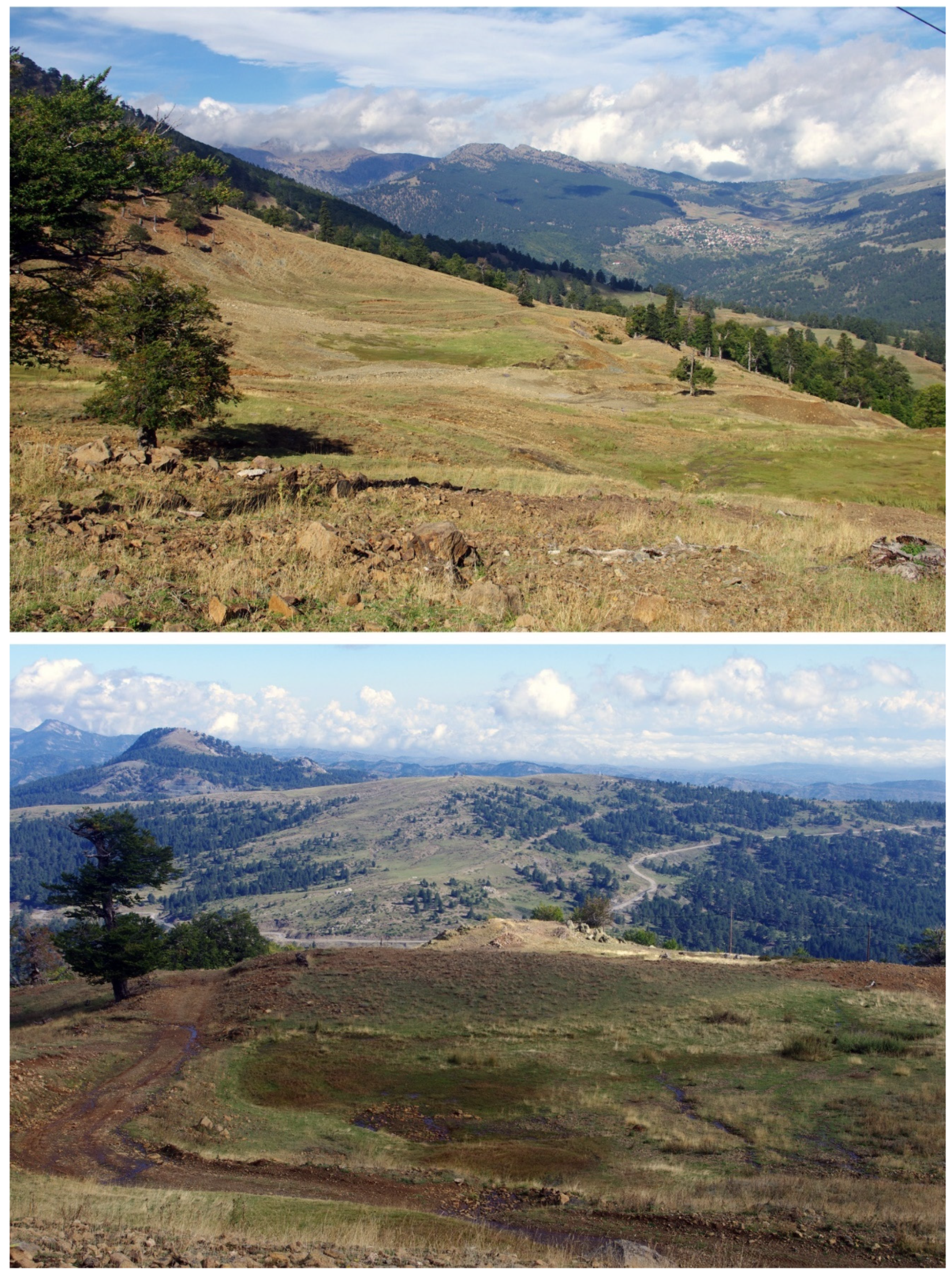
5. Results: The Natural and Human Landscape

This section discusses the most important Holocene archaeological sites discovered in the area, starting from Mount Vasilitsa (VSL and VSLA sites), moving north to the northern Mount Bogdani watershed (GRG) and the La Greklu-Delichmét ridge (a few Sam sites), Kirkuri (KRK), Anitsa (Anitsa and NTS sites), the Mirminda Pass and the watershed up to Mount Anitsa (VLC) and, finally, the Historical Camp (HC), just to the north-north-west of Samarina (Figure 1).

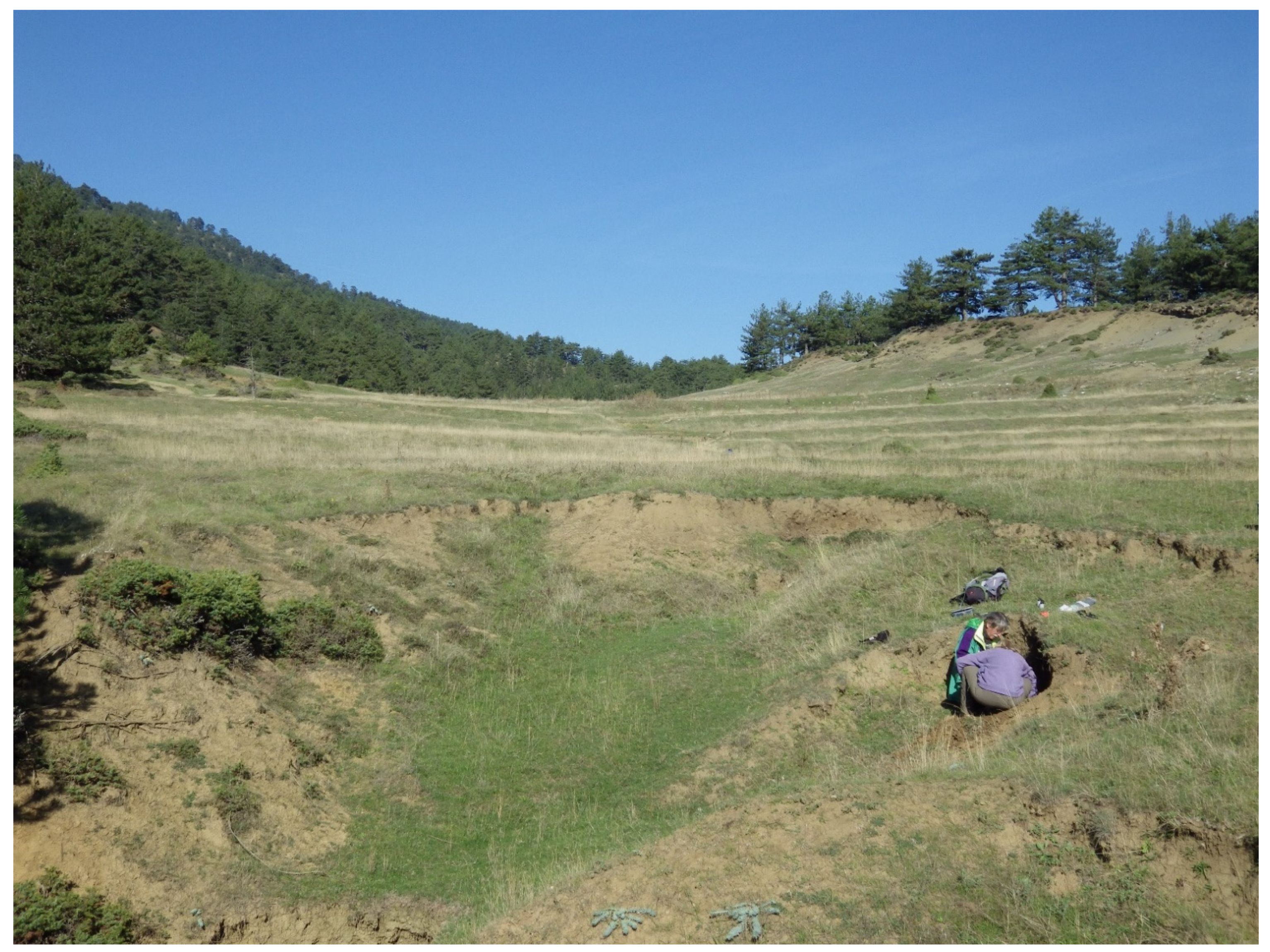
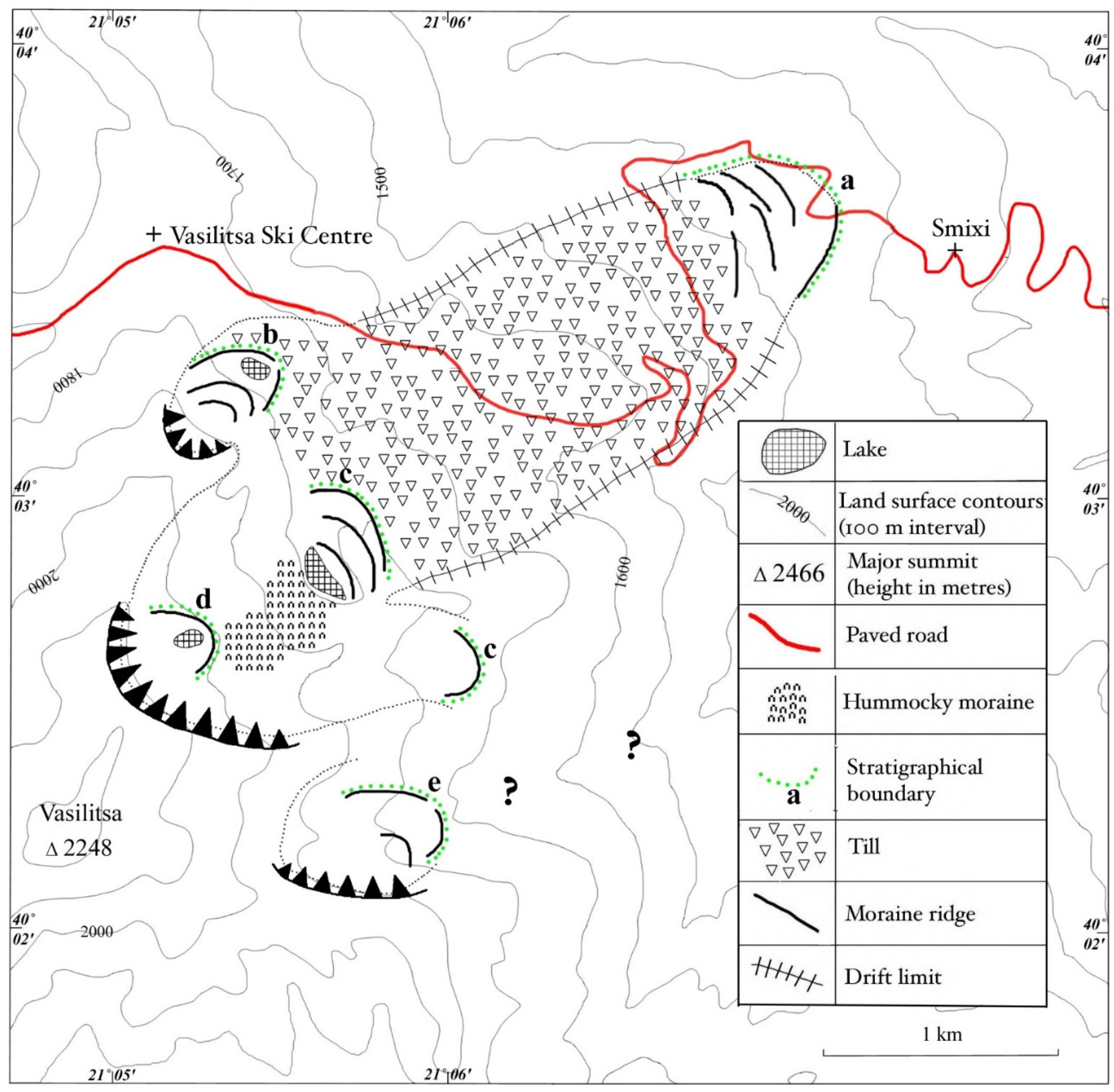
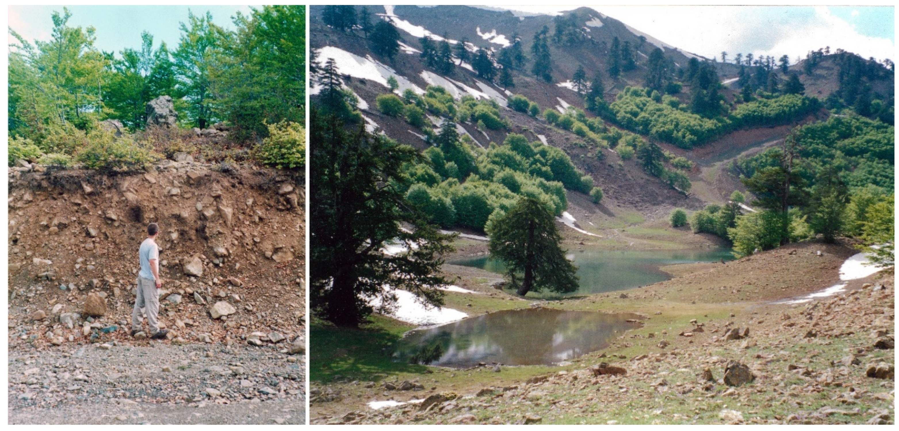
5.1. Evidence of Glaciers on Mount Vasilitsa

The glacial deposits on Mount Vasilitsa (2248 m a.s.l.) extend down to an elevation of ca. 1320 m a.s.l., just above the village of Smixi on the north-eastern slopes [73].
Good exposures are present in several places where sections are cut by roads and tracks, revealing a matrix-supported diamicton, and large perched rocks occur in many areas on a series of undulating moraine ridges.
The moraines resemble the glacial deposits noted elsewhere in ophiolite terrains such as those on Mount Smolikas [59,60] and Mavrovouni [67]. The lowest set of moraines on Vasilitsa are named the Smixi Member (Figure 13).
Further up-valley, moraine ridges impound a small lake on the north-eastern slopes at ca. 40°03′16″ N, 21°05′23″ E, 1750 m a.s.l. Two more ridges are present to the south-west of the lake. These sediments and landforms are named the North Vasilitsa Member and are interpreted as end and recessional moraine ridges formed in front of a former cirque glacier.
Moraine ridges also exist further south and impound a lake at ca. 40°02′52″ N, 21°05′40″ E, 1790 m a.s.l. (Figure 14). Here, at least three moraine ridge crests can be defined. These landforms are identified as the Central Vasilitsa Member. Hummocky, boulder-covered moraines are present up-valley of these ridges and probably formed during glacier retreat. A boulder ridge is also evident in the shallow valley to the southeast at ca. 1730 m a.s.l. and appears to represent the terminus of an off-shoot glacier which had the same source as the glacier which produced the lake moraines described above.
In the highest cirques on Vasilitsa, arcuate boulder moraines dam another lake (probably ephemeral) at ca. 2000 m a.s.l. and this youngest moraine unit is identified as the Vasilitsa Summit Member. These moraine ridges represent a discrete glacial advance during a later glacial phase. East of the summit of Vasilitsa, moraine ridges also exist in a small hollow at ca. 40°02′20″ N, 21°05′50″ E, 1730 m a.s.l. These deposits represent the East Vasilitsa Member. As this is the sole unit, these deposits also represent the East Vasilitsa Formation. Two main crests can be identified. No moraines were located down-valley, although lower glacial deposits may have been eroded [68].
The stratigraphy of the glacial sequence on Vasilitsa is summarised in Table 2. The lowest and most extensive moraines are Middle Pleistocene in age whilst only the highest cirque moraines were formed by small glaciers during the Late Pleistocene (Last Glacial Cycle). All of the chert artefacts reported in this paper have been found on the Middle Pleistocene moraines.
The lowest moraines of the Smixi Member formed during the Skamnellian Stage in the Greek glacial chronostratigraphy, which is equivalent to Marine Isotope Stage (MIS) 12, ca. 480–430,000 years ago [59].
The North and Central Vasilitsa Member moraines formed during the Vlasian Stage in the Greek glacial chronostratigraphy, which is equivalent to MIS 6a, ca. 190–130,000 years ago. The Vasilitsa Summit and East Vasilitsa Member cirque moraines belong to the Tymphian Stage in the Greek glacial chronostratigraphy, which is equivalent to MIS 5d-2, ca. 110,000–11,700 years ago.
In neighbouring mountains, the maximum extent of glaciers during this Last Glacial Cycle occurred ca. 30–25,000 years ago [67,74] (Figure 14). However, glaciers were present in the Pindus Mountains throughout the Last Glacial Cycle and oscillated in response to dramatic millennial-scale climate change. Neanderthals and, later, anatomically modern humans occupying the mountain early in the Last Glacial Cycle would have experienced open mountain terrain, late-lying snow and small cirque glaciers.
This open alpine terrain would have been attractive for hunting mountain fauna such as ibex and chamois [75]. For example, there is evidence from rock shelters on nearby Mount Tymphi that AMHs used these sites as bases from which to hunt ibex and chamois in the nearby open uplands [64,76,77]. Whilst the evidence from Mount Tymphi is of later Upper Palaeolithic AMH activity, it is likely that Neanderthals in this region were also hunting these animals on the glaciated landscapes on Vasilitsa and nearby glaciated areas such as Samarina.
It is certainly worth noting that Yravedra and Cobo-Sánchez [78] reported the importance of ibex and chamois in both Neanderthal and Modern human hunting behaviour in south-eastern Europe.

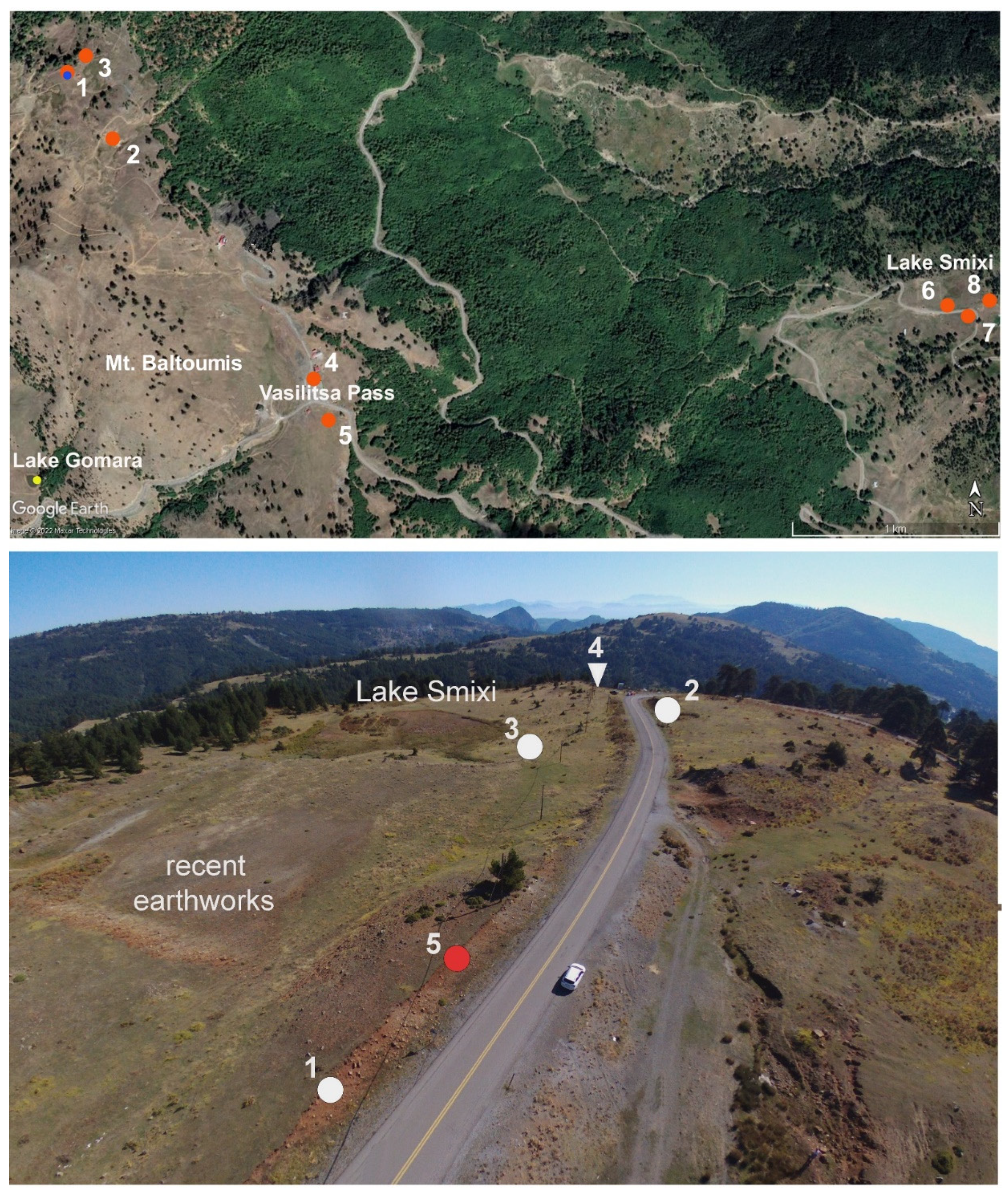
5.2. Vasilitsa Sites (VSL and VSLA)

Five sites in this area yielded artefacts attributable to different prehistoric periods. They were discovered along the northern slopes of Mount Baltoumis (2027 m a.s.l.), a secondary peak separated by Mount Vasilitsa by a wide saddle, and the Vasilitsa Pass itself (Figure 10 top).
Only three of them can be attributed to the Late Neolithic or the Early Bronze Age (VSL 1 and 2 and VSLA), although the assemblages show that the area was visited during different Pleistocene periods mainly by Middle Palaeolithic hunters. The chronology of the Vasilitsa Holocene sites is difficult to define due to the absence of radiocarbon datable material. None of the sites has been excavated and all the artefacts come from surface collections.
Site VSL 1 yielded the most important assemblages. It is located on a terrace delimited by a small pond, (Figure 10 top, n. 1; Figure 15 top). The site is located at 1770 m a.s.l. and extends over a surface of ca. 2000 square metres. It consists of a large patch of bare ground which is subjected to erosion due to summer grazing and human disturbance caused by the presence of ski infrastructure. One Pinus nigra charcoal fragment collected from a small fireplace discovered against a rock outcrop in the centre of the site gave a Late Byzantine age (VSL-1, GrA-69566: 995 ± 30 BP).
The site yielded several Holocene knapped stone artefacts, most of which are made from non-local, Epirotic chert, and one obsidian microflakelet which has been characterised as coming from the Slovak Carpathian 1 source (Figure 8, n. 2). The colours of the chert artefacts vary from black to blonde, brown, pinkish, light and dark grey. They consist of bladelet cores, technical pieces (crested blades), prismatic bladelets, and long and short-end scrapers (Figure 16, n. 3). Among the other tools are one straight perforator (Figure 6, n. 9), side scrapers, sickle inserts with sickle gloss, and arrowheads with bifacial invasive or covering flat-retouch (Figure 16, nn. 1, 2, 4 and 5; Figure 17, nn. 2 and 3), and other tools with cut or scrape wood, and cut hide use wears (Figure 16, nn. 6 and 7).
The assemblage includes two transverse arrowheads (Figure 18, n. 2), one of which had been hafted and used for cutting hard material (Figure 18, n. 1), one lunate fragment with impact traces (VSL-130). Green radiolarite was also utilised on a small scale, as well as light green soapstone (steatite) for making beads (Figure 19, n. 4). Other tools show wear traces of hafting and scraping wood and hide (Figure 19, nn. 2 and 3).
Site VSL 2 is located ca. 350 m south-east of Site 1, close to a small pond which attracts grazing flocks for their daily watering (Figure 10 top, n. 2; Figure 15 bottom). The assemblage was collected from a surface of ca. 1500 square metres. It consists of Middle Palaeolithic and Holocene artefacts exhumed by erosion due to pastoral land use.
Site 3 (VSLA: Figure 10 top, n. 3) is a small findspot discovered along the eastern, eroded and deeply incised slope of Mount Baltoumis, ca. 100 m north-east of Site 1. The assemblage is represented almost exclusively by Middle Palaeolithic artefacts, although a very few Late Neolithic tools were also found. The most representative is one greenstone chisel (Figure 9, n. 1), which finds generic parallels with some types from Servia ([79]: Plate 4.6), and one flat retouched point made from non-local pale red chert (Figure 19, n. 1).

5.3. The Smixi Moraine Ridges

One of the first areas targeted for our survey is a small glacial basin located at 1357 m a.s.l. just above the village of Smixi. A seasonal pond occupies a small depression in the pasture, whose southern side is delimited by the lower moraine of the Smixi Member which slopes down from the eastern flanks of Mount Vasilitsa. In some exceptionally wet years, the shallow basin is also filled with water during the summer season. The lowermost moraine ridge has been cut in several points by the road that connects the village of Smixi with the Vasilitsa Pass. Ground visibility is good, most of the area is deforested, and intensive grazing has eroded the grass cover in many areas.
The surveys conducted around the lake and along the moraine ridges which border it yielded some important traces of prehistoric activity mainly along the sections created by constructions of the new asphalt road (Figure 10 bottom). They consist of three Middle Palaeolithic refitting flakes (Figure 20, nn. 1–4), 2 Mousterian discoidal cores with centripetal detachments (Figure 20, nn. 5 and 6), and one pre-core (Figure 21, n. 1) made of local whitish chert. All these artefacts are important for the definition of the chronology of the lowermost moraines of Mount Vasilitsa (Figure 14). The three conjoining Levallois flakes are very fresh, covered with a reddish patina, which shows that they were embedded within the red clayey soil deposits of the moraine most probably since the Late Pleistocene.
One unique Palaeolithic tool made of local chert was collected a few metres away from the lake, along the slope down to the village of Smixi. It is a point made from a long blade with a facetted butt and direct, bilateral retouch (Figure 21, n. 2). This tool has no parallel with any Palaeolithic artefact retrieved from the surveyed Samarina region. Its cultural and chronological attributions are difficult to define, although the technology of the laminar blank would suggest an Upper Palaeolithic age.
A small pit discovered along the open profile of the southernmost ridge of the moraine yielded a few ceramic potsherds and pine charcoal fragments (Figure 10 bottom, n. 5) The latter were radiocarbon-dated to 3645 ± 35 BP (GrA-69503: SMX-1). The result shows that the moraines that surround Smixi Lake were briefly visited also around the beginning of the Bronze Age (see Table 1: SMX-1).

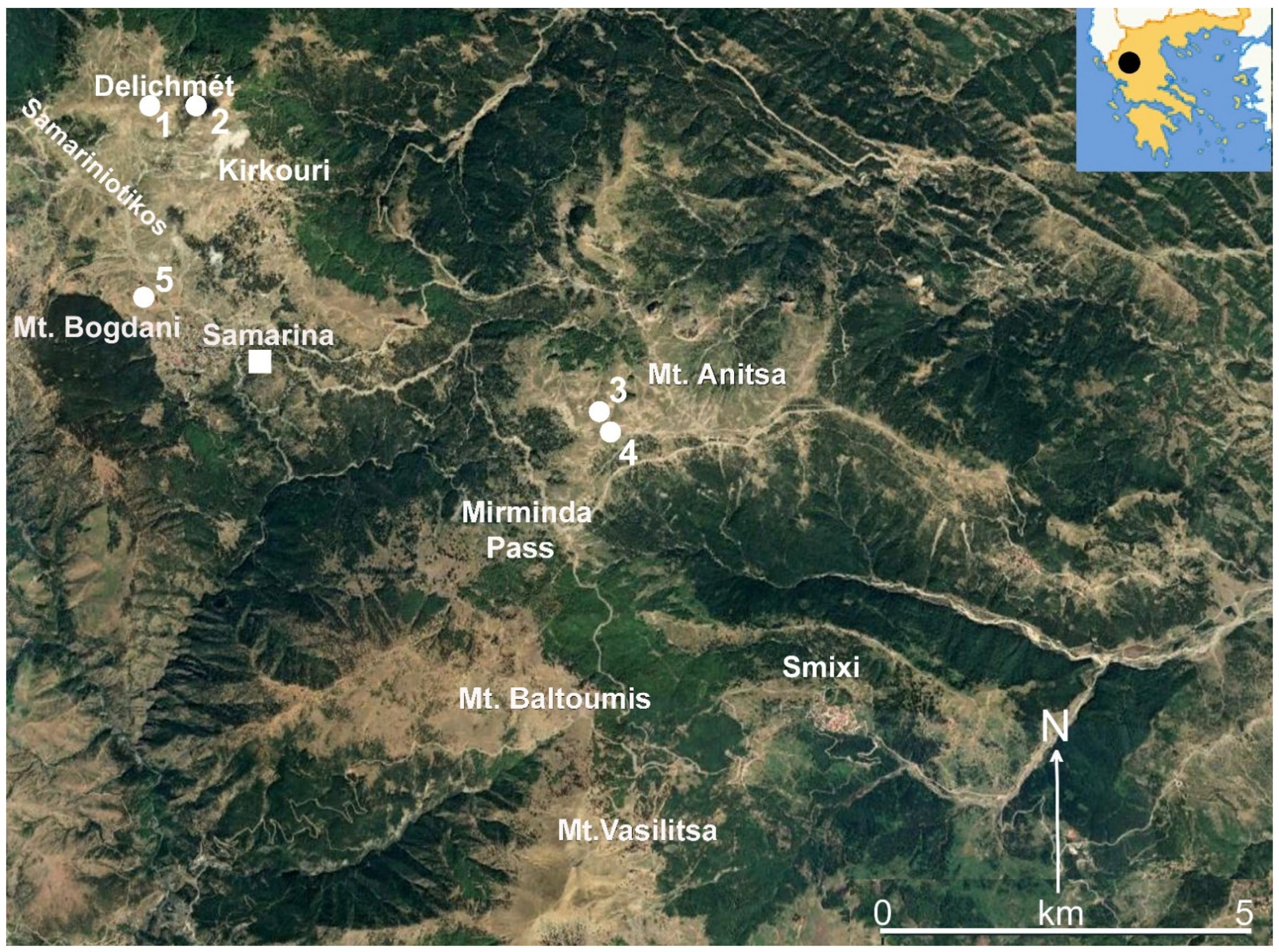
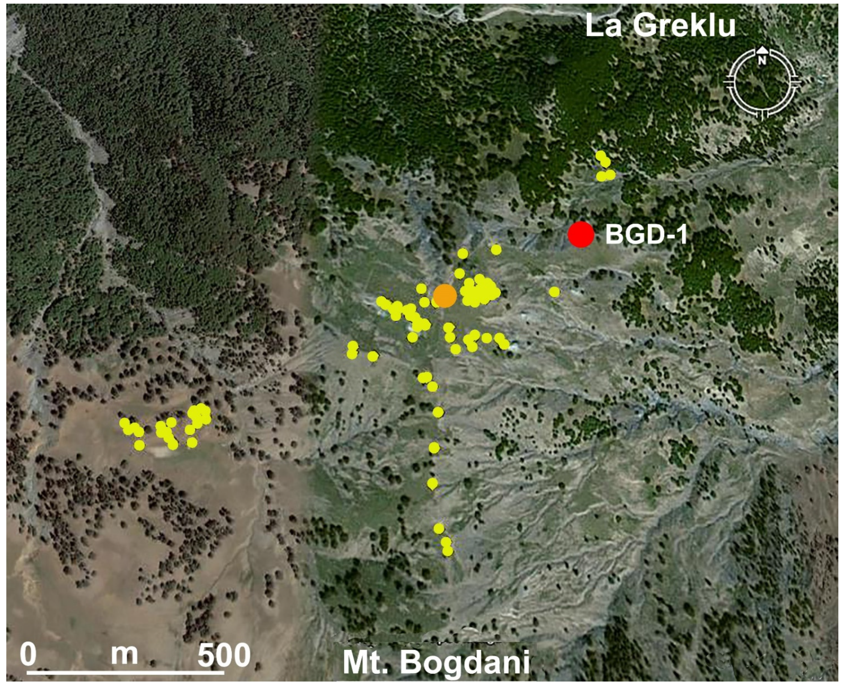
5.4. La Greklu-Delichmét Watershed

The watershed that extends between La Greklu and Delichmét is marked by very impressive chert outcrops. Two important sites were partly excavated: Sam-8 (40°08′10.7″ N, 20°00′22.0″ E: 1782 m a.s.l.) (Figure 1, n. 1) and Sam-5 (40°08′14.4″ N, 21°00′53.5″ E: 1778 m a.s.l.) (Figure 1, n. 2).
The 2 × 3 m. trench opened in 2003 in Sam-8, a site whose surface is gently inclined towards north-west ca. 3–4°, yielded evidence of a complex evolution of soil formations. It showed that this part of the watershed was deforested during the Bronze and Iron Ages (see Figure 3; Table 1). This led to the incision and disturbance of the lower-lying Pleistocene deposit, characterised by polygonal patterns [24], which yielded a few Middle Palaeolithic artefacts. Unique lithic tools were collected from the Holocene horizon, which was partly damaged by the construction of a new road.
They include one greenstone chisel (Figure 9, n. 2), which finds some parallels in a few Bronze Age specimens from Servia ([79], Figure 4.6) and one bifacial artefact made from local chert (Figure 19, n. 5). One triangular, barbed-and-tanged, bifacial arrowhead made from Vikos “black chert” (Figure 7, n. 2.) was recovered in situ along the profile of the site which continues for ca. 20 m and is marked by a line of small charcoal pieces and lithic artefacts.
Quite a different situation was recorded from Sam-5. One 2 × 3 m test trench was opened in 2004 close to the limestone outcrop locally called Delichmét, and to the point where a few Late Mesolithic artefacts were collected along both sides of the new road [23]. The excavation yielded only a few historic ceramic potsherds, among which is a double-pierced handle, and a small fireplace, which was radiocarbon-dated to the Byzantine period (DEM-1917/OxA-16222: 1129 ± 26 BP, and DEM-1918/OxA-16223: 1127 ± 25 BP). In a profile cleaned in the Pleistocene deposit below the Historic occupation, evidence of buried Middle Palaeolithic artefacts was observed. The trench did not yield any evidence of Mesolithic occupation.

5.5. Kirkuri (KRK)

Kirkuri is a rounded peak (1855 m a.s.l.) with one wide area of bare ground on its top (Figure 22) caused by overgrazing and the construction of transmission antennas. The survey of this peak yielded various types of Palaeolithic and Holocene knapped stone artefacts [22].
Among the latter, the area yielded four fragmented arrowheads made from non-local chert, by bifacial, covering, flat retouch. They consist of one, almost complete, barbed-and-tanged, triangular type (Figure 7, n. 1), two have a concave base (Figure 7, n. 3 and 4), and one is too small a fragment to have an idea of its original shape (Figure 7, n. 6). From a techno-typological point of view, all the Kirkuri arrowheads can be attributed to the Bronze Age.

5.6. Mount Anitsa (Anitsa and NTS)

Mount Anitsa has played an important role in the prehistory and recent history of the Samarina region, for reasons that can be partly explained by the events that took place during WWII [80]. The reasons why the conquest of Mount Anitsa was so important for the end of the war are to be found in the strategic location and shape of the mountain, which gives access to the Western Macedonian Plain, in the east, and offers good visibility from which all the valleys around can be controlled. Given these features, it is not surprising that a Middle/Late Bronze Age site (Sam-29) was established on its top (1705 m a.s.l.). The 2 × 3 m excavation trench opened in 2007 did not yield any evidence of archaeological features. A few characteristic Bronze Age fine-ware shards were recovered [81], and a few Quercus sp. charcoal pieces, one of which was radiocarbon-dated to 3095 ± 35 BP (GrA-51015).
Important discoveries were also made on the upper slope of the same mountain, facing south. Dozens of shatters and hyper-microflakelets knapped from Vikos “black chert” were found scattered over a surface of ca. 5 square metres associated with a partly retouched large flake of the same raw material, most probably the rough-out of an arrowhead (Figure 5, n. 1). These finds suggest the presence of an in situ chert manufacturing area. A few tiny pieces of Fraxinus sp. charcoal recovered from 25 cm of depth in association with Vikos “black chert” artefacts, yielded an age of 5356 ± 26 BP (GrM-28122: NTS-25). The radiocarbon date shows that the workshop was active during the Late Neolithic. The presence of one microlithic isosceles trapeze obtained by two parallel, abrupt truncations from a bladelet with trapezoidal cross-section supports this conclusion (Figure 18, n. 5).
All of the higher north-western flanks of Mount Anitsa sloping down to an unnamed narrow valley, which separates Anitsa from the Skourdza peak (1799 m a.s.l.), yielded many Middle Palaeolithic and Late Holocene artefacts scattered along the slope. Among the latter are different types of non-local chert bifacial arrowheads (Figure 18, nn. 8–10), one end scraper, a few bladelets with parallel sides, among which is a sickle insert with hafting traces on a snapped, abrupt-retouched bladelet (Figure 17, n. 1), and a few unretouched artefacts knapped from Vikos “black chert” (Figure 6, n. 7). Along the same slope, the site called Sam-23 is located at ca. 1666 m a.s.l., close to a spring. The site has been attributed to the Chalcolithic mainly due to a radiocarbon date obtained from a juniper charcoal fragment (GrA-59661: 4005 ± 35 BP). The 2 × 3 m trench opened in 2004 did not yield any archaeological features. Among the collected lithics are two significant artefacts made from non-local chert. They consist of a sickle bladelet on a snapped, unretouched, blank with a trapezoidal cross-section (Figure 17, n. 6), and one atypical, asymmetric geometric armature obtained by two opposed marginal truncations (Figure 18, n. 4).

5.7. The Mirminda Pass (VLC)

Another watershed, which has yielded many artefacts of different ages, extends between the Mirminda Pass (1556 m a.s.l.), in the south, and Mount Anitsa, in the north-north-east (Figure 1). The Mirminda Pass must be crossed to reach the Samarina basin moving from the Grevena lowland and the Aliakmon River. Due to its location, the pass probably played a very important role in prehistory, because it separates two important rivers, the first of which flows into the Ionian Sea, to the west, and the second into the Aegean, to the east. Just north of the Mirminda Pass, a few important tools were recovered: one triangular, tanged-and-barbed, flat-retouched, bifacial arrowhead made from patinated dark bluish-grey chert (Figure 7, n. 7), and the tang of another arrowhead made by flat unifacial retouch (Figure 7, n. 8). Other finds were collected along the watershed, though most of them come from a sheltered area close to Mount Anitsa. Among them is one insert with sickle gloss (Figure 17, n. 4), and a few Vikos “black chert” artefacts, among which is one truncation (Figure 18, n. 3). The assemblage includes also two quartzarenite pebbles, which were most probably employed as hammerstones or fabricators.

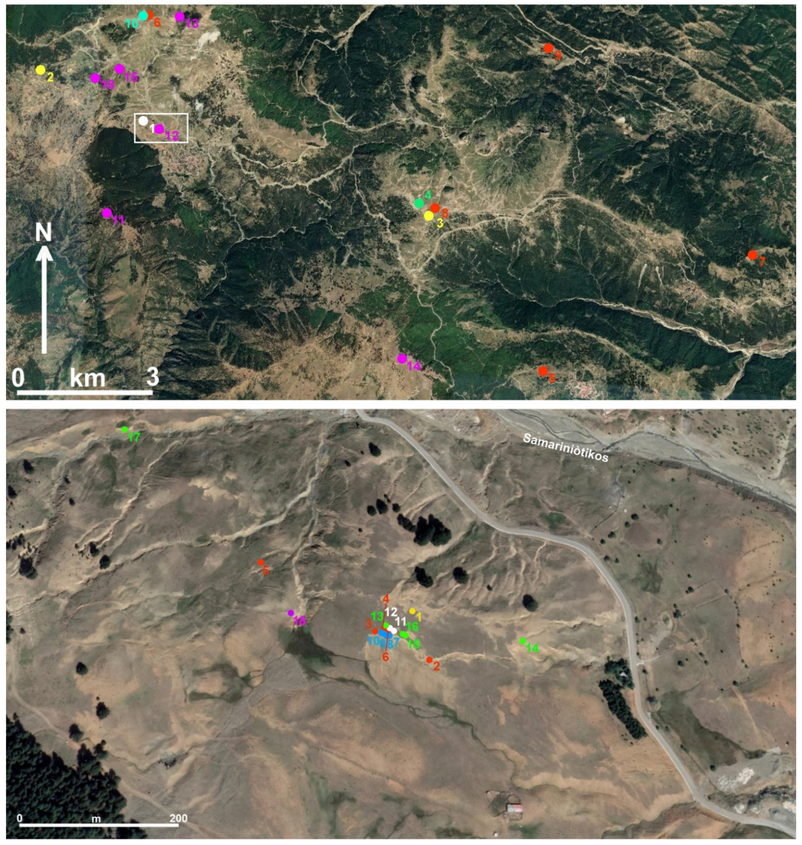
5.8. The Historical Camp (HC)

The so-called Historical Camp (HC) is located just north-north-west of Samarina at ca. 1530–1550 m a.s.l., east of a Middle Pleistocene moraine ridge that slopes down from Mount Gurguliu. The area, from which come some 300 artefacts, many of which have been attributed to the Middle Palaeolithic, though also to different Holocene periods, looks almost flat, although it is incised by several gullies (Figure 23 top). A small pond marks the northernmost edge of the HC (Figure 23 bottom).
A 2 × 3 m test trench was opened close to the deepest gully (40°06′41.3” N, 21°00′33.9” E). It yielded structures which were attributed to the historical campsite but it was devoid of material culture remains. The structures consisted of two diverging postholes and two shallow pits filled with juniper carbonised branches, one of which was radiocarbon-dated to the Byzantine period (DEM-2586: 1414 ± 18 BP) (Figure 24).
The same HC area yielded at least 80 “black spots”, buried by ca. 20 cm of colluvial sediments, which were interpreted as remains of burnt tree-pits related to intentional deforestation episodes [82]. The features show evidence of anthropogenic thermal impact and contain a few charcoal pieces [25].
One was excavated (HC-5: Figure 25) and 18 were sampled for radiocarbon-dating. The radiocarbon ages show that the deforestation of the territory took place in different periods of the Holocene (see Figure 2 bottom and Table 1) and continued into the nineteenth century ([2], see p. 45).

6. Discussion

The occurrence of high-altitude archaeological sites of the Late Holocene age has only rarely been reported in the Balkan Peninsula [10]. The surveys made around Samarina have shed new light on the potential for discovering sites of this period at high elevations and for establishing why and when these landscapes were visited or settled.
In our case, knapped stone artefacts play an important role because potsherds, bones and other archaeological remains in most cases have been destroyed by the acidity of the mountain soil [14,83]. A few important points can be noted about lithics in the Samarina mountain zone. They show (1) the importance of non-local chert for understanding regional connections and ancient pathways, and the geographic location and distance of the lithic sources exploited during the Late Holocene; (2) the reason why a few types of knapped stone artefacts repeatedly recur in some specific areas; (3) their significance, and the role they played in the economic subsistence of the sites from which they have been retrieved; and (4) the presence of artefacts made from exogenous materials probably transported from very distant sources. We expand on each of these themes below.
(1)
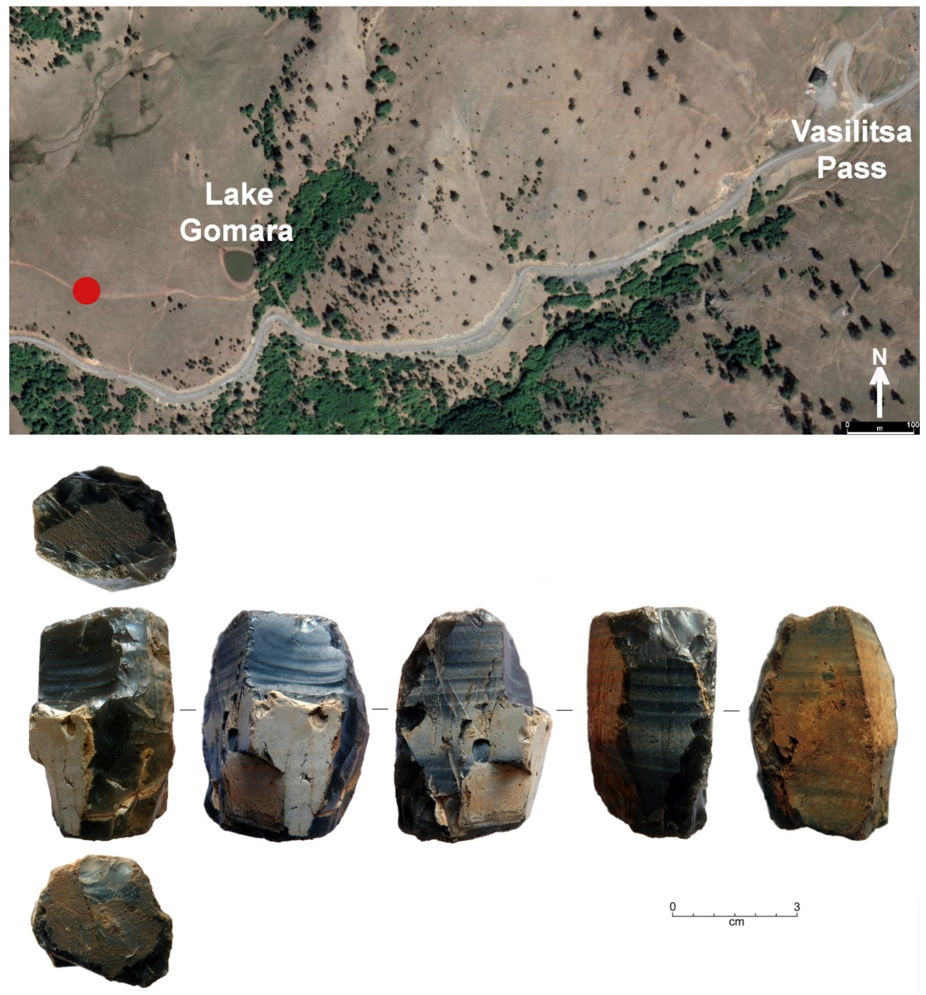
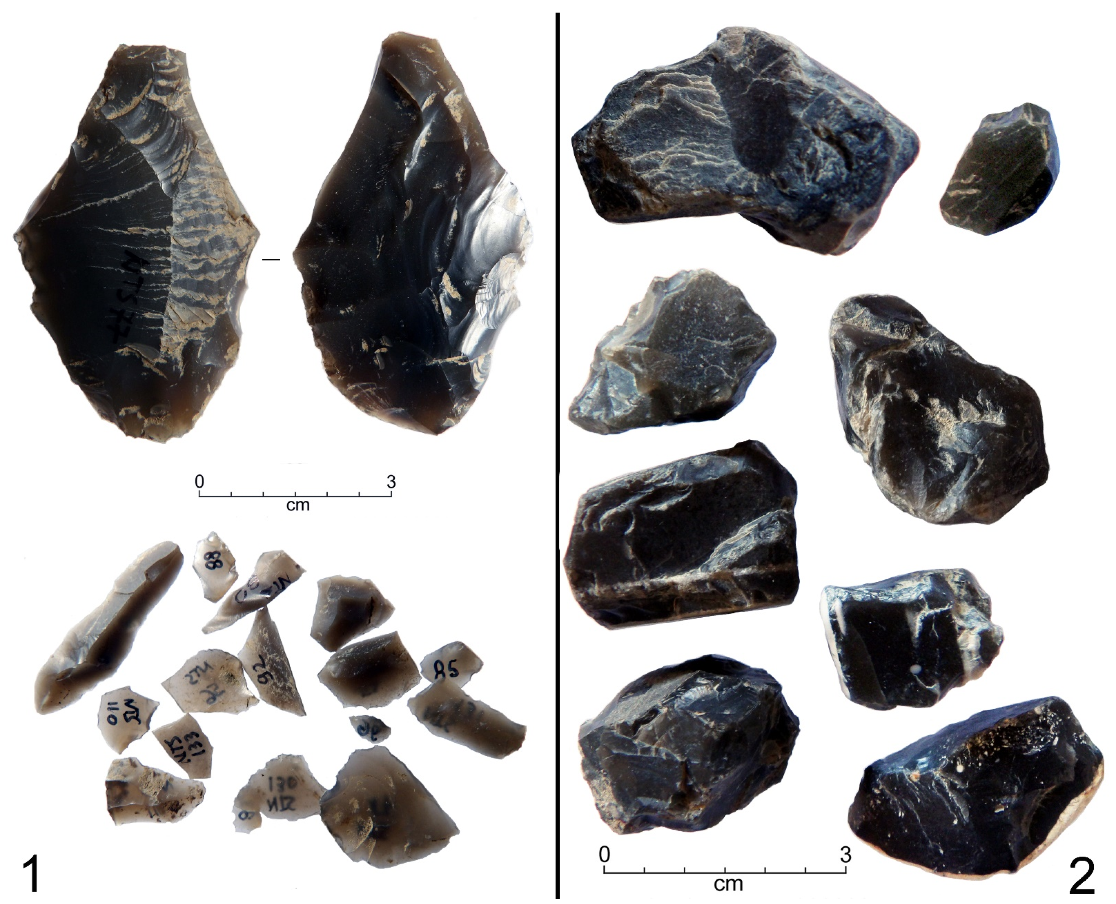
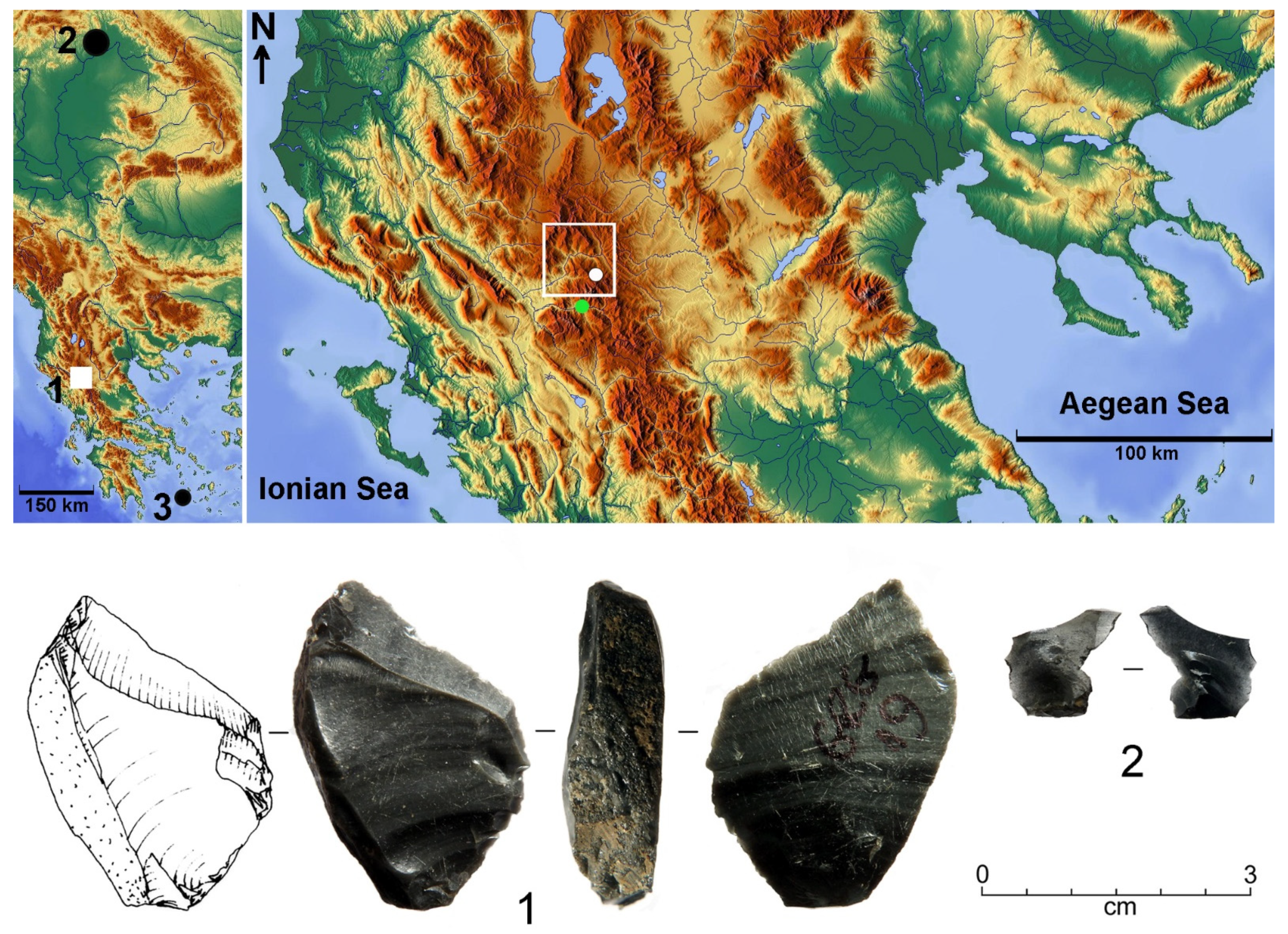
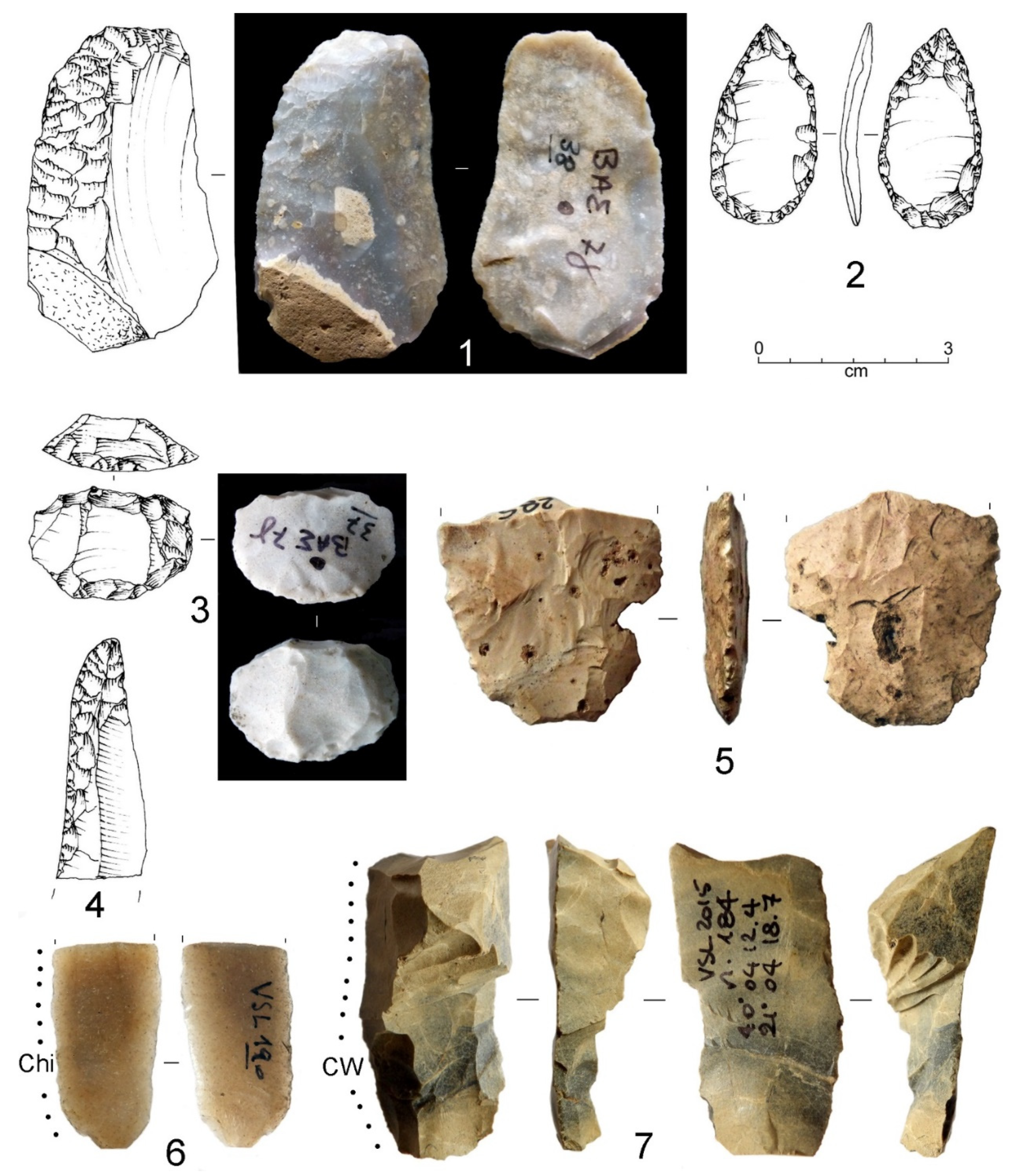
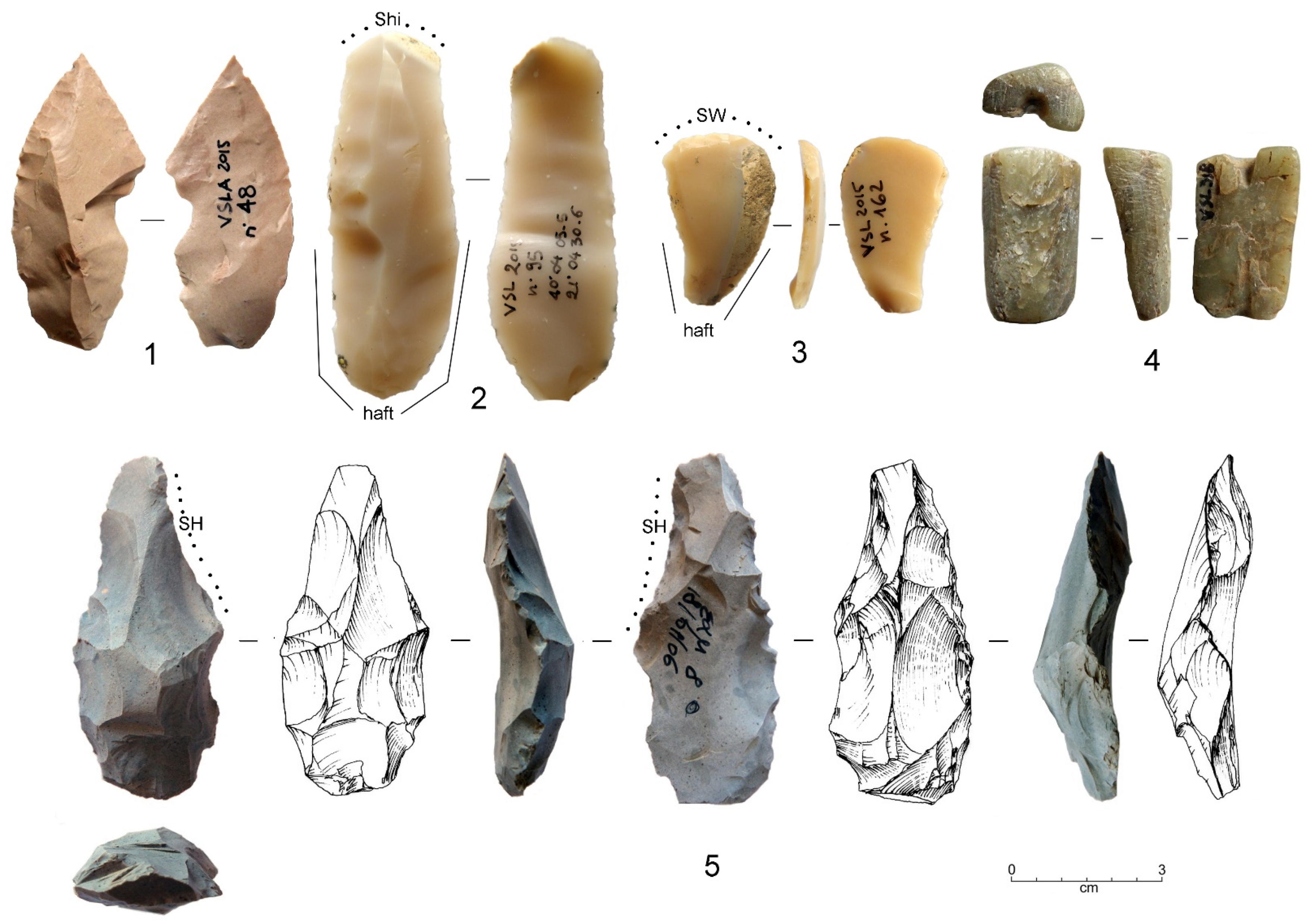
Almost all the lithic artefacts from the Holocene Samarina sites are made from non-local, good-quality, knappable material. Apart from the Vikos “black chert”, other non-local chert types were utilised, though their sources have not been yet identified. One probable pre-core of Vikos “black chert” was collected from the surface ca. 1 km west of the Vasilitsa Pass, close to the Gomara Lake (Figure 4 bottom). Artefacts and debitage flakes made from this chert, whose outcrops are well-known in Epirus, ca. 25–30 km south-west of the study area, have been recovered from many sites of the Samarina highlands (see for example Mounts Vasilitsa, Anitsa, the watersheds around Delichmét and the Mirminda Pass and others). The Vikos “black chert” pre-core most probably punctuates one of the routes which were followed to transport this raw material and reinforces the impression that it was transported as blocks or rough-outs and not as finished tools. This interpretation is confirmed by the Mount Anitsa NTS debitage waste spot, which was radiocarbon-dated to the Late Neolithic (GrM-28122), and the recovery of many debitage flakelets and a few cores from the Mount Baltoumis site VSL 1. The triangular tanged-and-barbed arrowhead collected along the profile of site Sam-8, which finds a close parallel from Dispilio ([84], Figure 7), was made from this type of exogenous chert (Figure 7, n. 2);
(2)
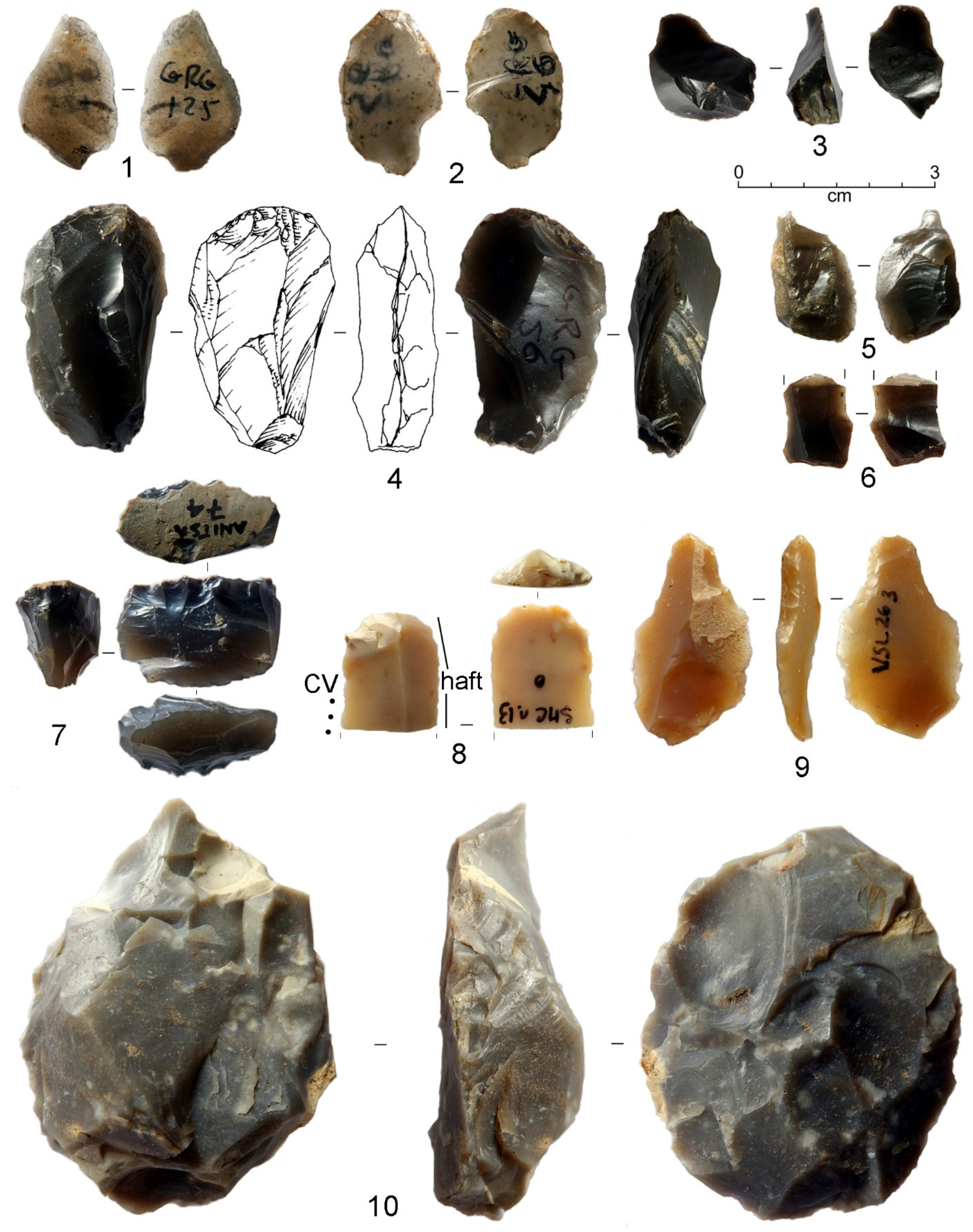
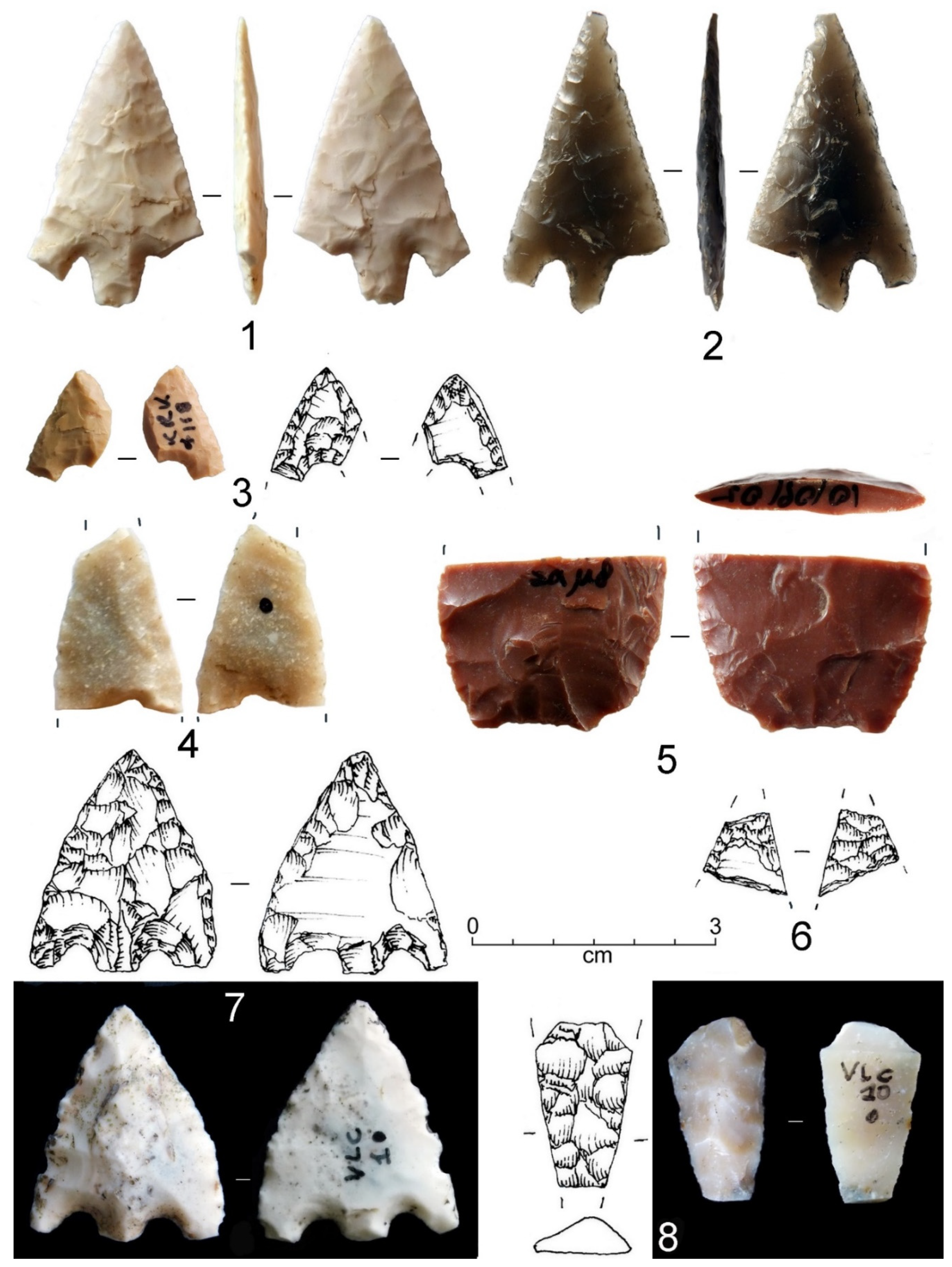
The knapped stone artefacts are represented mainly by long and short-end scrapers, sickle inserts and flat-retouched arrowheads. Different types of sickle inserts were recovered (Figure 17), two of which show the characteristic, shining, sickle gloss (Figure 17, nn. 1 and 6). One specimen has been resharpened (Figure 17, n. 4), and one has a notched working edge (Figure 17, n. 3). The typological variability of the sickle inserts has been discussed in several papers and explained as being due to their chronology, function, harvesting method and production technology [85,86,87].
(3)
Other characteristic tools consist of arrowheads, all made from non-local chert. Unfortunately, we know very little about the techno-typology and chronology of the flat-retouched arrowheads from Greece, mainly because, apart from a few exceptions, they have never been studied in detail [88,89,90]. This contrasts with the evidence from other parts of Europe, where these items and their variability have been studied in detail to interpret the changes and complexity of societal structure mainly during the Chalcolithic and Bronze Age periods [91,92].
(4)
Arrowheads and daggers were utilised for different uses, one of which was undoubtedly hunting. They were recovered along most of the watersheds and some of the highest and most strategic points. The presence of lithic arrowheads at high elevations is not surprising, although the Samarina samples are the first ever published from the Greek mountains. A large quantity of chert and obsidian arrowheads are attested in the Aegean since the Neolithic. Many have been found in Thessaly and other regions of northern Greece, although during the Bronze Age chert arrowheads were still used in several parts of the Greek mainland and Crete [93].
(5)
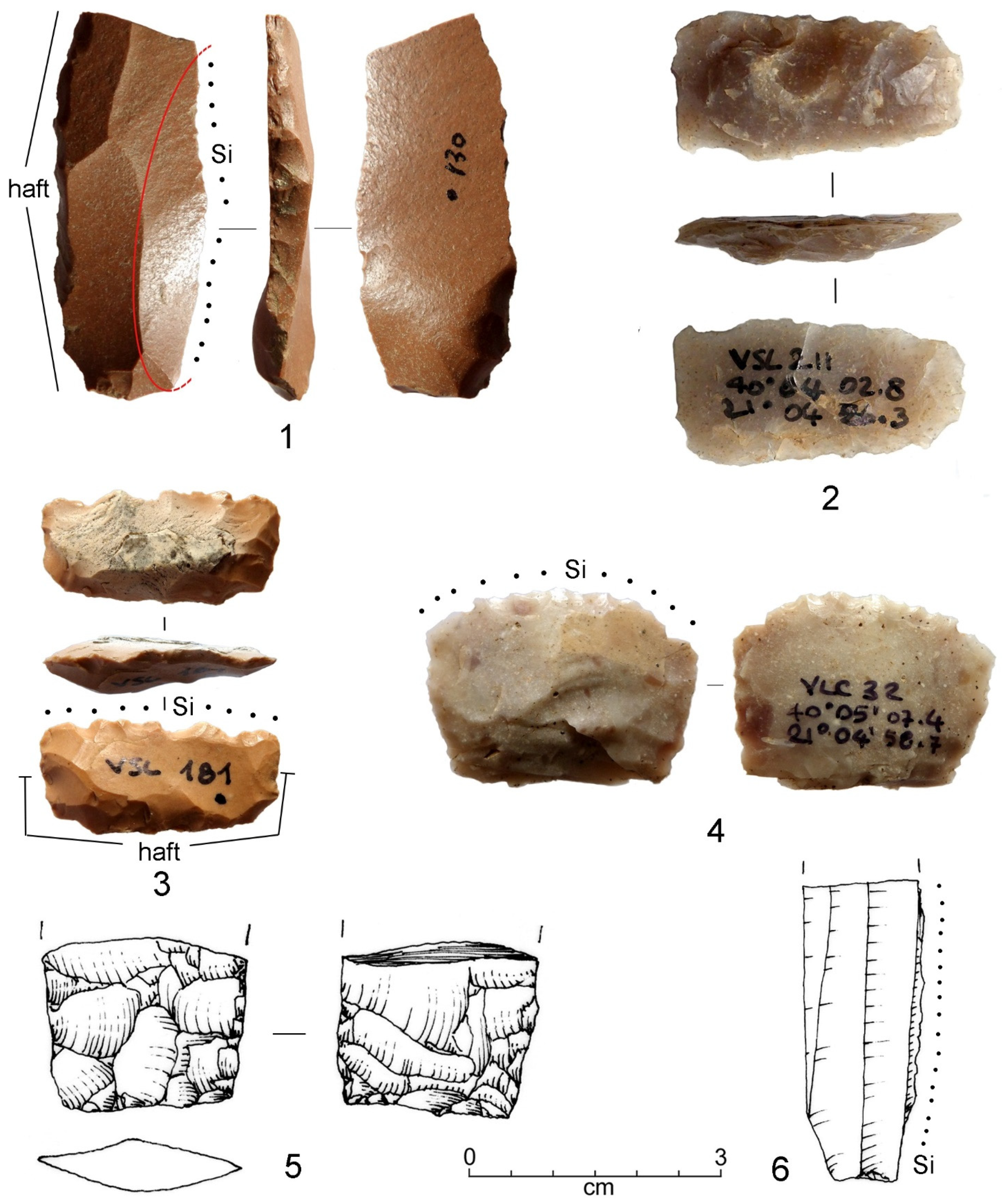
The artefacts from the Mount Baltoumis sites (VSL) show that different activities were performed at high altitudes, including agriculture, hunting and woodworking. Chert tools, and also prestige items were produced within Site 1. This is shown by the presence of exhausted cores, debitage pieces and one broken steatite bead with unfinished perforations (Figure 19, n. 4). Some lithic artefacts were hafted (Figure 18, n. 1) or used for cutting hide (Figure 16, n. 6), wood (Figure 16, n. 7) and piercing (Figure 6, n. 9).
(6)
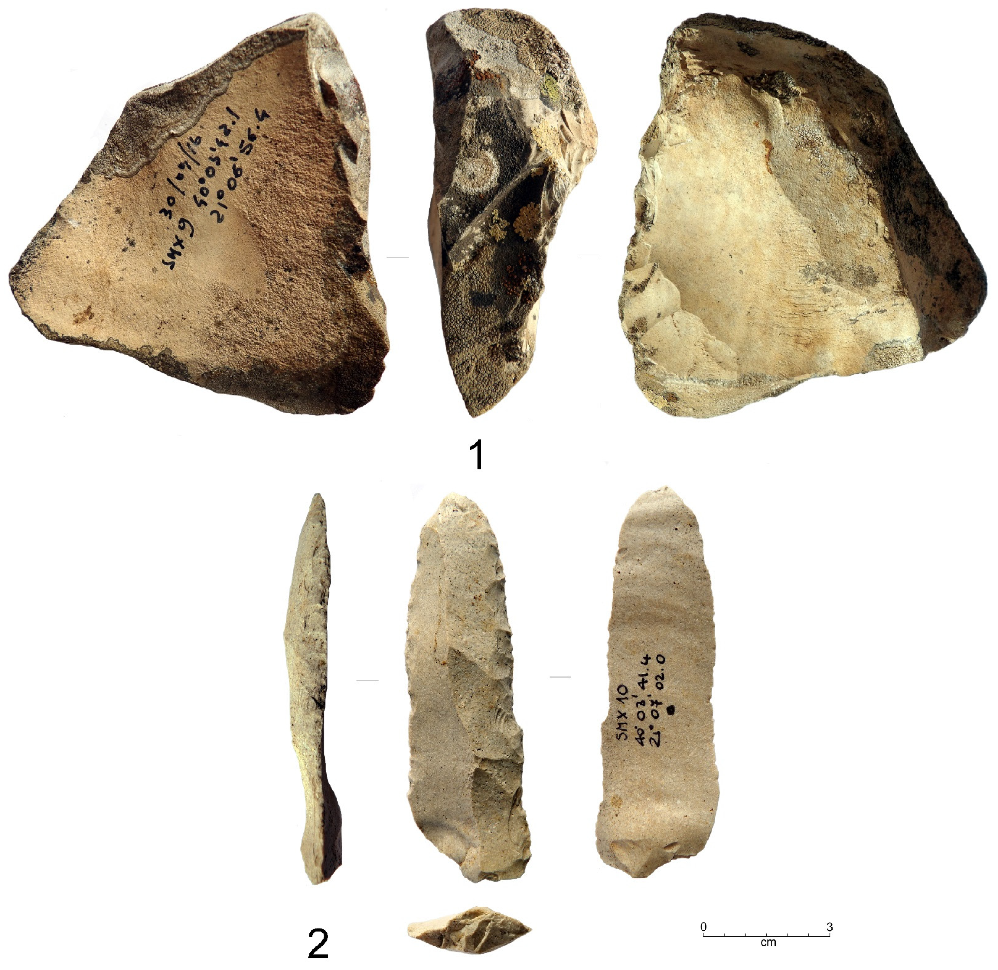
As reported above, two obsidian flakes have been collected from site VSL 1 (VSL-139) and the northern watershed of Mount Bogdani (GRG-19) (Figure 8). These undiagnostic finds, although their chrono-cultural attribution is difficult to define, reopen the question of the distribution and spread of archaeological obsidian in continental Greece. The first, which preserves part of the cortex on one side, comes from the Island of Melos, and the second from the Slovak source Carpathian 1. Both finds are very important because they were collected from territories located out of the distribution limit currently known for both Melian and Carpathian 1 obsidian [94]. Quite unexpectedly, they show that the Samarina mountain sites were part of the long-distance obsidian distribution network. Both are knapping by-products, which can be considered proxies for the circulation of obsidian nodules rather than finished products. The occurrence of both Carpathian and Aegean obsidian in Western Macedonian was previously known only from the sites of Mandalo and Dispilio [95,96,97].

7. Conclusions

The surveys conducted in the Samarina highlands during the last 20 years have led to the discovery of many traces of human activities attributable to the Late Holocene [98], more precisely to prehistoric periods between the Late Neolithic and the end of the Bronze Age. However, recent discoveries have shown that groups of Epipalaeolithic and Early Mesolithic hunter-gatherers were the first to move up to the north Pindus Range most probably during the warm interstadials that characterise the end of the Pleistocene and also around the beginning of the Holocene [22]. The Preboreal Mesolithic presence is confirmed by the recovery of one characteristic microlithic point made from Vikos “black chert”, and one radiocarbon date obtained from Salix charcoal recovered from two distinct, though neighbouring points of the HC site (HC-CH20: GrM-25076). Moreover, the discovery of a few Epipalaeolithic and Early Mesolithic artefacts would help confirm the suggested hypothesis that north-western Greece and neighbouring Albania were “parts of a mobility system of hunter-gatherer tied to the systemic habitat of prehistoric populations” ([99], p. 76).
Apart from the Early Holocene finds, which include also a few typical early Atlantic Late Mesolithic artefacts [23], the Samarina highlands started to be more systematically inhabited during the Late Neolithic. Two radiocarbon dates from charcoal pieces obtained from a small fireplace discovered along the northern piedmont of Mount Bogdani (BGD-1: DEM-2585), and from a thin charcoal horizon from one of the Mount Anitsa profiles (NTS-25: GrM-28122), confirm this view. The results show that Late Neolithic farmers started to move up to the north Pindus mountains during two different times in the sixth millennium BP. The evidence provided by the two dates are reinforced (1) by the presence of a small Vikos “black chert” knapping floor at ca. 1700 m a.s.l. (NTS), most probably for the production of a flat, bifacial point, and (2) the recovery of a Carpathian 1 obsidian flakelet ca. 300 m south-west of the BGD-1 fireplace, along a Mount Bogdani ridge that yielded many other non-local Holocene chert artefacts.
These data show that Vikos “black chert” has been exploited here since the early Holocene and transported to the Samarina highlands, a movement that continued and increased throughout the entire Chalcolithic and the Bronze Age. Moreover, they show the importance of the relationships that developed with the Epirus middle-altitude mountain landscapes.
The discovery of a few Bronze Age high-altitude sites, structures (pits), and material culture remains, among which are different types of lithic artefacts and ceramic potsherds, is also important. According to the available radiocarbon chronology, the area started to be seasonally (?) frequented during the early Bronze Age (SMX-1: GrA-69503), to continue until the end of the same period. It is important to note the presence of one large valley bottom settlement at Agios Athanasios (ca. 1110 m a.s.l.), along the right terrace of the Venetikos River. This discovery is important for several reasons. The Venetikos joins the Aliakmon River ca. 50 km south-east of the site, to flow into the Aegean Sea. This means that this river system has nothing in common with the Epirus Vikos chert supply zone, and the route through which this important knappable source was transported. Moreover, Agios Athanasios (AA) is the only Bronze Age valley bottom site known in the study area, though it is likely that many others exist. In this regard, the discovery of a radiocarbon-dated charcoal lens associated with a few potsherds, near Koutroulia, close to the village of Filippei, at ca. 1330 m a.s.l. (KRN-45: GrM-25075), an area which again faces south-east, is of great interest.
Despite the two middle-altitude occurrences, it is important to emphasise that most of the Chalcolithic and Bronze Age sites have been found at high elevations. The settlement that was partly excavated and located on the top of Mount Anitsa (Sam-29: GrA-59015) is a typical observation point from which the entire surrounding region can be controlled. More Bronze Age sites are well-known in other key areas, among which are La Greklu and Mount Vasilitsa. The first, which is still undated, yielded a few potsherds, while the chronology of Mount Baltoumis sites VSL-1 and VSL-2 is not well-defined. Some of the lithic artefacts from these two sites are most probably attributable to this period (Figure 17, nn. 2 and 3). One of the sickle inserts can be compared with very similar bifacial sickles on flakes with a notched working edge from other early Bronze Age sites excavated in Western Macedonia and in the Peloponnese [100].
The available evidence shows that the Bronze Age high-altitude sites were part of a complex network, which involved movements from the valley bottoms and middle-altitude territories of Western Macedonia and Epirus to the Samarina highlands. Moreover, the recovery of many flat-retouched chert arrowheads along watersheds and their presence within Bronze Age sites (Sam-8: Figure 7, n. 2), show that the footpaths on the Samarina ridges were already opened, the visibility was good for hunting, and the entire area could be easily crossed on foot at least by the beginning of the Bronze Age, most probably also during the Chalcolithic. This is suggested by the presence of one site of this age along the upper slopes of Mount Anitsa (Sam-23: GrA-59661), where hunting activities are evidenced also by the presence of one lunate armature with impact fracture traces. Another point to note is the systematic occurrence of Bronze Age findspots close to springs or water sources, which are numerous all over the study region. A distinctive Bronze Age example is the flat-retouched transversal arrowhead labelled Sam-11 (Figure 18, n. 6) recovered from an area of springs, just south of La Greklu Pass, at ca. 1600 m a.s.l.
Figure 3 shows the results obtained from the archaeological sites and the Historical Camp tree-pits, which mark the periods during which the deforestation of the HC area took place. The calibration plot shows evident discontinuities between the most important cultural periods, which are represented by gaps within both groups of dates, for example between the Late Neolithic and the Bronze Age, and again between the Bronze, Iron and Roman Ages. Though we know very little about the Iron Age, pit-graves of this period containing different ceramic and bronze items were found at Spelaion (ca. 950 m a.s.l.), some 25 km south-east of Samarina [101]. Regarding the Roman period, charcoal pieces from a small Roman Age smelting kiln at 1939 m a.s.l. along the western upper slope of Mount Gurguliu, yielded an age of 1755 ± 30 BP (GrA-59658). This evidence is intriguing, despite our very limited knowledge of activities of this age in the study area that undoubtedly took place in the early Roman Imperial period, most probably due to the presence of the important Egnatia Odos, which crossed this mountain region, and the recovery of small metal slags along the slopes of the same mountains, though their age could not be ascertained. The existence of Roman (?) smelting ore ([2], p. 177) and coinage mint are reported to be practised until a few centuries ago at the edge of Valia Kalda along the southern slopes of Mount Smolikas.
The discovery of Byzantine fireplaces at Delichmét (Sam-5: DEM-1918/OxA-16223 and DEM-1917/OxA-16222), VSL-1 (GrA-69566), and other places show that the Samarina highlands were also settled in this period, as they were during the Roman Imperial rule. This evidence contrasts with the lack of radiocarbon results attributable to the Hellenistic period, which is otherwise represented by two important middle-altitude settlements along the Smixiotikos River, both known as Kastrì [102].
To sum up, the results obtained during this long-term research programme carried out in the Samarina highlands have shown the great potential of such surveys to enhance archaeological knowledge in unexplored mountain areas, and to help frame it within a wider cultural network. It is important to state that the territory we have explored has been exploited for centuries by seasonal Vlach transhumant shepherds, whose presence has led to deforestation and grazing, and the consequent exposure of many open spaces, which would otherwise be covered with thick forests and reduced visibility. In this respect, it is important to point out that the investigated territory is not only unique, but also represents an ideal landscape for conducting archaeological research. The amount of data collected so far is very significant from this point of view.

Author Contributions

Conceptualization, P.B., E.S. and N.E.; methodology, P.B., E.S., P.D.H. and N.E.; software, R.N.; writing—original draft preparation, P.B., E.S. and N.E.; writing—review and editing, P.B., E.S., R.N., P.D.H., N.E. and J.C.W.; funding acquisition, N.E., P.B. and E.S. All authors have read and agreed to the published version of the manuscript.

Funding

This research was jointly supported from grants from the Aristotle University, Thessaloniki (Greece), Ca’ Foscari University, Venice (Italy), The Prefecture of Western Macedonia (Greece), and the Institute for Aegean Prehistory (INSTAP, USA). E.S. received funds from the University of Pisa (Italy), Excellence Project of the Department of Civilizations and Forms of Knowledge, n. 429999-DIP-ECCELL-CIVILTA-2018-2022.

Data Availability Statement

All data used during the study appear in the article.

Acknowledgments

The authors are very grateful to three anonymous reviewers for their constructive comments and suggestions. Special thanks are due to B. Gratuze (IRAMAT, CNRS, Orléans, F) for the characterisation of the obsidian artefacts, and B.A. Voytek (Archaeological Research Facility, Berkeley University, Berkeley, CA, USA), for the traceological analyses of some of the knapped stone artefacts.

Conflicts of Interest

The authors declare no conflict of interest.

References

  1. Hammond, N.G.L. Epirus: The Geography, the Ancient Remains, the History and the Topography of Epirus and Adjacent Areas; Clarendon Press: Oxford, UK, 1967. [Google Scholar]
  2. Wace, A.J.B.; Thompson, M.S. The Nomads of the Balkans: An Account of Life and Customs among the Vlachs of the Northern Pindus; Biblo & Tannen: Cambridge, UK, 1913. [Google Scholar]
  3. Winnifrith, T.J. The Vlachs: The History of a Balkan People; Duckworth: London, UK, 1987. [Google Scholar]
  4. Koukoudis, A.I. The Vlachs: Metropolis and Diaspora; Zitros: Thessaloniki, Greece, 2003. [Google Scholar]
  5. Russell, J.; Cohn, R. Alchiviad Diamandi di Samarina; Bookvika Publishing: Edinburgh, UK; Lennex Corp.: Edinburgh, UK, 2012. [Google Scholar]
  6. Broglio, A. Mountain sites in the context of the North-East Italian Upper Palaeolithic and Mesolithic. Preist. Alp. 1992, 28, 293–310. [Google Scholar]
  7. Biagi, P.; Nandris, J. (Eds.) Highland Zone Exploitation in Southern Europe; Monografie di Natura Bresciana; Museo Civico di scienze naturali di Brescia: Brescia, Italy, 1994; Volume 20, pp. 7–338. [Google Scholar]
  8. Franco, C. La Fine del Mesolitico in Italia. Identità Culturale e Distribuzione Territoriale degli Ultimi Cacciatori-Raccoglitori (The end of the Mesolithic in Italy. Cultural Identity and Territorial Distribution of the Last Hunter-Gatherers); Società per la Preistoria e Protostoria della Regione Friuli-Venezia Giulia, Quaderno 13, Centralgrafica: Trieste, Italy, 2011. (In Italian) [Google Scholar]
  9. Francis, K.; Vulpi, V. The Italian notebooks and reports and their English translations. In Explorations in Albania. The Notebooks of Luigi Cardini, Prehistorian with the Italian Archaeological Mission; Francis, K., Ed.; The British School at Athens: London, UK, 2005; Supplementary Volume NO. 37, pp. 11–182. [Google Scholar]
  10. Schon, R.; Galaty, M.L. Diachronic Frontiers: Landscape Archaeology in Highland Albania. J. World-Syst. Res. 2006, XII, 231–262. [Google Scholar] [CrossRef] [Green Version]
  11. Mihailović, D. (Ed.) Palaeolithic and Mesolithic in the Central Balkans; Serbian Archaeological Society: Belgrade, Serbia, 2014. [Google Scholar]
  12. Bobînă, B. Mountain Archaeology in Romania: The Status of Research. Terra Sebus. Acta Musei Sabesiensis 2015, 7, 149–164. [Google Scholar]
  13. Beck, J.; Ciugudean, H.; Quinn, C.P. Bioarchaeology and Mountain Landscapes in Transylvania’s Golden Quadrangle. Bioarchaeol. Int. 2020, 4, 89–110. [Google Scholar] [CrossRef]
  14. Halstead, P. Present to past in the Pindhos: Diversification and specialisation in mountain economies. In Archeologia della Pastorizia in Europa Meridionale; Maggi, R., Nisbet, R., Barker, G., Eds.; Rivista di Studi Liguri: Bordighera, Italy, 1990; Volume 56, pp. 61–80. [Google Scholar]
  15. Chang, C. Pastoral Transhumance in the Southern Balkans as a Social Ideology: Ethnoarcheological Research in Northern Greece. Am. Anthropol. 1993, 95, 687–703. [Google Scholar] [CrossRef]
  16. Chang, C.; Tourtellotte, P.A. Ethnoarchaeological Survey of Pastoral Transhumance Sites in the Grevena Region, Greece. J. Field Archaeol. 1993, 20, 249–264. [Google Scholar] [CrossRef]
  17. Ntassiou, K.; Doukas, I.D. Recording and mapping traditional transhumance routes in the South-Western Macedonia, Greece. GeoJournal 2019, 84, 161–181. [Google Scholar] [CrossRef]
  18. Dakaris, S.I.; Higgs, E.S.; Hey, R.W.; Tippett, H.; Mellars, P. The Climate, Environment and Industries of Stone Age Greece: Part I. Proc. Prehist. Soc. 1964, 30, 199–244. [Google Scholar] [CrossRef]
  19. Runnels, C.; Korkuti, M.; Galaty, M.L.; Timpson, M.E.; Whittaker, J.C.; Stocker, S.R.; Davis, J.L.; Bejko, L.; Mucaj, S. The Palaeolithic and Mesolithic of Albania: Survey and excavation at the site of Kryegjata B (Fier District). J. Mediterr. Archaeol. 2004, 17, 3–29. [Google Scholar] [CrossRef]
  20. Biagi, P.; Nisbet, R.; Michniak, R.; Efstratiou, N. The Chert Outcrops of the Pindus Range of Western Macedonia (Greece) and their Middle Palaeolithic Exploitation. Quarry 2015, 11, 3–16. [Google Scholar]
  21. Biagi, P.; Nisbet, R.; Starnini, E.; Efstratiou, N.; Michniak, R. Where Mountains and Neanderthals Meet: The Middle Palaeolithic Settlement of Samarina in the Northern Pindus (Western Macedonia, Greece). Eurasian Prehistory 2017, 13, 3–76. [Google Scholar]
  22. Biagi, P.; Nisbet, R.; Efstratiou, N. Late Palaeolithic and Early Mesolithic finds from the Pindus Mountains of western Macedonia (Greece). Antiq. Proj. Gallery 2015, 346. Available online: https://www.antiquity.ac.uk/projgall/biagi346 (accessed on 25 July 2016).
  23. Biagi, P.; Efstratiou, N.; Starnini, E.; Nisbet, R. Traces of Mesolithic occupation in the Pindos Mountains of western Macedonia (Greece). Mesolith. Misc. 2023; 30, in press. [Google Scholar]
  24. Efstratiou, N.; Biagi, P.; Elefanti, P.; Karkanas, P.; Ntinou, M. Prehistoric exploitation of Grevena highland zones: Hunters and herders along the Pindus chain of western Macedonia (Greece). World Archaeol. 2006, 38, 415–435. [Google Scholar] [CrossRef]
  25. Biagi, P.; Nisbet, R. Archeologia della pastorizia dei Vlah di Samarina (Macedonia Occidentale, Grecia) (Archaeology of the pastoralism of the Vlachs of Samarina (Western Macedonia, Greece). In Un Accademico Impaziente. Studi in Onore di Glauco Sanga; Ligi, G., Pedrini, G., Tamisari, F., Eds.; Edizioni dell’Orso: Alessandria, Italy, 2018; pp. 581–593. (In Italian) [Google Scholar]
  26. Reimer, P.J.; Austin, W.E.N.; Bard, E.; Bayliss, A.; Blackwell, P.; Bronk Ramsey, C.; Butzin, M.; Cheng, H.; Edwards, R.L.; Friedrich, M.; et al. The IntCal20 Northern EmisphereRadiocarbon Age Calibration Curve (0–55 cal kBP). Radiocarbon 2020, 62, 725–757. [Google Scholar] [CrossRef]
  27. Management Unit of Northern Pindos National Park; National System of Governance of Protected Areas, Natural Environment and Climate Change Agency (N.E.C.C.A.): Athens, Greece, 2021–2022.
  28. Pouqueville, F.-C.H.-L. Voyage de la Grèce, 2nd ed.; Firmin Didot: Paris, France, 1826. [Google Scholar]
  29. Leake, W.M. Travels in Northern Greece; J. Rodwell: London, UK, 1835. [Google Scholar]
  30. Konter, O.; Krusic, P.J.; Trouet, V.M.; Esper, J. Meet Adonis, Europe’s oldest dendrochronologically dated tree. Dendrochronologia 2017, 42, 12. [Google Scholar] [CrossRef]
  31. Klippel, L.; Krusic, P.J.; Brandes, R.; Hartl-Meier, C.; Trouet, V.; Meko, M.; Esper, J. High-elevation inter-site differences in Mount Smolikas tree-ring width data. Dendrochronologia 2017, 44, 164–173. [Google Scholar] [CrossRef]
  32. Klippel, L.; Krusic, P.J.; Brandes, R.; Hartl, C.; Belmecheri, S.; Dienst, M.; Esper, J. A 1286-year hydro-climate reconstruction for the Balkan Peninsula. Boreas 2018, 47, 1218–1229. [Google Scholar] [CrossRef]
  33. Christopoulou, A.; Fyllas, N.M.; Gmińska-Nowak, B.; Özarslan, Y.; Arianoutsou, M.; Brandes, R.; Ważny, T. Exploring the past of Mavrovouni forest in the Pindus Mountain range (Greece) using tree rings of Bosnian pines. Trees 2022, 36, 153–166. [Google Scholar] [CrossRef]
  34. Esper, J.; Klippel, L.; Krusic, P.J.; Konter, O.; Raible, C.C.; Xoplaki, E.; Luterbacher, J.; Büntgen, U. Eastern Mediterranean summer temperatures since 730 CE from Mt. Smolikas tree-ring densities. Clim. Dyn. 2020, 54, 1367–1382. [Google Scholar] [CrossRef]
  35. Esper, J.; Konter, O.; Klippel, L.; Krusic, P.J.; Büntgen, U. Pre-instrumental summer precipitation variability in northwestern Greece from a high-elevation Pinus heldreichii network. Int. J. Climatol. 2021, 41, 2828–2839. [Google Scholar] [CrossRef]
  36. Chester, P.I. Late Holocene Vegetation History of Grevena Province, Northwestern Greece. Ph.D. Thesis, Victoria University of Wellington, Wellington, New Zealand, 1988, unpublished. Available online: http://hdl.handle.net/10063/507 (accessed on 30 June 2021).
  37. Ntokos, D. Synthesis of Literature and Field Work Data Leading to the Compilation of a New Geological Map—A Review of Geology of Northwestern Greece. Int. J. Geosci. 2017, 8, 205–236. [Google Scholar] [CrossRef] [Green Version]
  38. Wong, K.; Draper, K.; Feng, L.; Hawkins, P.; Oakley, S.; Zheng, X.X. The geology of Mount Orliakas and the Pindos Ophiolite, Greece. Bull. Geol. Soc. Greece 2019, 54, 144–177. [Google Scholar] [CrossRef] [Green Version]
  39. Hourmouziadis, G. Dispilio, Kastoria a Prehistoric Lakeside Settlement; Codex: Thessaloniki, Greece, 1966. (In Greek) [Google Scholar]
  40. Facorellis, Y.; Sofronidou, M.; Hourmouziadis, G. Radiocarbon Dating of the Neolithic Lakeside Settlement of Dispilio, Kastoria, Northern Greece. Radiocarbon 2014, 56, 511–528. [Google Scholar] [CrossRef] [PubMed]
  41. Kakavakis, O. In search of social networks during the Neolithic Period in Macedonia (Νorthern Greece): The case of chipped stone industries. In A Century of Research in Prehistoric Macedonia 1912–2012; Stefani, E., Merousis, N., Dimoula, A., Eds.; Archaeological Museum: Thessaloniki, Greece, 2014; pp. 599–606. [Google Scholar]
  42. Elefanti, P.; Marshall, G.; Stergiou, C.L.; Kotjabopoulou, E. Raw material procurement at Boïla Rockshelter, Epirus, as an indicator of hunter-gatherer mobility in Greece during the Late Upper Palaeolithic and Early Mesolithic. J. Archaeol. Sci. Rep. 2021, 35, 102719. [Google Scholar] [CrossRef]
  43. Kotjabopoulou, E.; Panagopoulou, E.; Adam, E. The Boïla Rockshelter: A Preliminary Report. In Klithi: Palaeolithic Settlement and Quaternary Landscapes in Northwest Greece. Volume 2: Klithi in Its Local and Regional Settling; Bailey, G.N., Ed.; McDonald Institute for Archaeological Research: Cambridge, UK, 1997; pp. 427–437. [Google Scholar]
  44. Lewin, J.; Macklin, M.G.; Woodward, J.C. Late Quaternary Fluvial Sedimentation in the Voidomatis Basin, Epirus, Northwest Greece. Quat. Int. 1991, 35, 103–115. [Google Scholar] [CrossRef]
  45. Adam, E. To Know and To Have: Raw Material Availability and Upper Palaeolithic Stone Assemblage in Epirus. In Klithi: Palaeolithic Settlement and Quaternary Landscapes in Northwest Greece. Volume 2: Klithi in Its Local and Regional Settling; Bailey, G.N., Ed.; McDonald Institute for Archaeological Research: Cambridge, UK, 1997; pp. 481–496. [Google Scholar]
  46. Ozsvárt, P.; Dosztály, L.; Migiros, G.; Tselepidis, V.; Kovács, S. New radiolarian biostratigraphic age constraints on Middle Triassic basalts and radiolarites from the Inner Hellenides (Northern Pindos and Othris Mountains, Northern Greece) and their implications for the geodynamic evolution of the early Mesozoic Neotethys. Int. J. Earth Sci. 2012, 101, 1487–1501. [Google Scholar] [CrossRef]
  47. Stirn, M.A. Why all the way up there? Mountain and high-altitude archaeology. SAA Archaeol. Rec. 2014, 14, 7–10. [Google Scholar]
  48. Ballbè, E.G.; Conte, I.C.; Mazzucco, N.; Casas, D.G.; Gomez, L.O.; Anton, D.R. Surface surveying in high mountain areas, is it possible? Some methodological considerations. Quat. Int. 2016, 402, 35–45. [Google Scholar] [CrossRef] [Green Version]
  49. Biagi, P.; Nisbet, R.; Starnini, E. High-Altitude Archaeology in Southeastern Europe. In Encyclopedia of Global Archaeology; Smith, C., Ed.; Springer Nature: Cham, Switzerland, 2019; pp. 5033–5051. [Google Scholar] [CrossRef]
  50. Morgan, C. Was it Euphoria or Oxygen Deprivation? Reflexions on Conducting Research in Alpine Settings. SAA Archaeol. Rec. 2014, 14, 31–35. [Google Scholar]
  51. Tzortzis, S.; Delestre, X. Archéologie de la Montagne Européenne; Bibliothèque d’Archéologie Méditerranéenne et Africaine: Paris, France, 2010. [Google Scholar]
  52. Biagi, P.; Starnini, E. Human settlement and environmental exploitation of Valcamonica-Valtrompia watershed from the beginning of the Holocene to the Middle Ages. Nat. Brescia 2015, 39, 249–259. [Google Scholar]
  53. Biagi, P.; Starnini, E. Archeologia d’alta quota: Alcuni esempi dalle Alpi centrali (Highland Zone Archaeology: Some Examples from the Central Alps). In Una Preziosa Eredità. Scritti in Ricordo di Arturo Palma di Cesnola; Sarti, L., Martini, F., Eds.; Museo e Istituto Fiorentino di Preistoria: Florence, Italy, 2021; Volume 24, pp. 261–275. (In Italian) [Google Scholar]
  54. Steward, J.H. Causal Factors and Processes in the Evolution of Pre-farming Societies. In Man the Hunter; Lee, R.B., DeVore, I., Eds.; Aldine: New York, NY, USA, 1968; pp. 321–334. [Google Scholar]
  55. Binford, L.R. Long-term Land-use patterning: Some Implications for Archaeology. In Working at Archaeology; Binford, L.R., Ed.; Academic Press: New York, NY, USA, 1981; pp. 379–386. [Google Scholar]
  56. Schiffer, M.B.; Sullivan, A.P.; Klinger, T.C. Field Techniques and Research Design. World Archaeol. 1978, 10, 1–28. Available online: https://www.jstor.org/stable/124409 (accessed on 29 June 2021). [CrossRef]
  57. Binford, L.R. A Consideration of Archaeological Research Design. Am. Antiq. 1964, 29, 425–441. Available online: https://www.jstor.org/stable/277978 (accessed on 29 June 2021). [CrossRef]
  58. Leontaritis, A.D.; Kouli, K.; Pavlopoulos, K. The glacial history of Greece: A comprehensive review. Mediterr. Geosci. Rev. 2020, 2, 65–90. [Google Scholar] [CrossRef] [Green Version]
  59. Hughes, P.D.; Woodward, J.C.; Gibbard, P.L.; Macklin, M.G.; Gilmour, M.A.; Smith, G.R. The glacial history of the Pindus Mountains, Greece. J. Geol. 2006, 114, 413–434. [Google Scholar] [CrossRef]
  60. Hughes, P.D.; Gibbard, P.L.; Woodward, J.C. Middle Pleistocene glacier behaviour in the Mediterranean: Sedimentological evidence from the Pindus Mountains, Greece. J. Geol. Soc. 2006, 163, 857–867. [Google Scholar] [CrossRef]
  61. Pope, R.J.; Hughes, P.D.; Skourtsos, E. Glacial history of Mt Chelmos, Peloponnesus, Greece. Geol. Soc. Lond. Spec. Publ. 2017, 433, 211–236. [Google Scholar] [CrossRef] [Green Version]
  62. Pavlopoulos, K.; Leontaritis, A.; Athanassas, C.D.; Petrakou, C.; Vandarakis, D.; Nikolakopoulos, K.; Stamatopoulos, L.; Theodorakopoulou, K. Last glacial geomorphologic records in Mt Chelmos, North Peloponnesus, Greece. J. Mt. Sci. 2018, 15, 948–965. [Google Scholar] [CrossRef]
  63. Smith, G.W.; Damian Nance, R.; Genes, A.N. Quaternary glacial history of Mount Olympus, Greece. Geol. Soc. Am. Bull. 1997, 109, 809–824. [Google Scholar] [CrossRef]
  64. Woodward, J.C.; Hamlin, R.H.B.; Macklin, M.G.; Karkanas, P.; Kotjabopoulou, E. Quantitative sourcing of slackwater deposits at Boïla rockshelter: A record of lateglacial flooding and Paleolithic settlement in the Pindus Mountains, Northwest Greece. Geoarchaeol. Int. J. 2001, 16, 501–536. [Google Scholar] [CrossRef]
  65. Wilson, G.P.; Reed, J.M.; Frogley, M.R.; Hughes, P.D.; Tzedakis, P.C. Reconciling diverse lacustrine and terrestrial system response to penultimate deglacial warming in southern Europe. Geology 2015, 43, 819–822. [Google Scholar] [CrossRef] [Green Version]
  66. Wilson, G.P.; Frogley, M.R.; Hughes, P.D.; Roucoux, K.H.; Margari, V.; Jones, T.D.; Leng, M.J.; Tzedakis, P.C. Persistent millennial-scale climate variability in Southern Europe during Marine Isotope Stage 6. Quat. Sci. Adv. 2021, 3, 100016. [Google Scholar] [CrossRef]
  67. Leontaritis, A.D.; Pavlopoulos, K.; Marrero, S.M.; Ribolini, A.; Hughes, P.D.; Spagnolo, M. Glaciations on ophiolite terrain in the North Pindus Mountains, Greece: New geomorphological insights and preliminary 36Cl exposure dating. Geomorphology 2022, 413, 108335. [Google Scholar] [CrossRef]
  68. Hughes, P. Quaternary Glaciation in the Pindus Mountains, Northwest Greece. Ph.D. Thesis, The University of Cambridge, Cambridge, UK, 2004, unpublished. [Google Scholar]
  69. Bailey, G.N.; Lewin, J.; Macklin, M.; Woodward, J. The “Older Fill” of the Voidomatis Valley, North-west Greece and Its Relationship to the Palaeolithic Archaeology and Glacial History of the Region. J. Archaeol. Sci. 1990, 17, 145–150. [Google Scholar] [CrossRef]
  70. Bailey, G.N. (Ed.) Klithi: Palaeolithic Settlement and Quaternary Landscapes in Northwest Greece. Volume 1: Excavation and Intra-Site Analysis at Klithi; McDonald Institute for Archaeological Research: Cambridge, UK, 1997. [Google Scholar]
  71. Woodward, J.C.; Macklin, M.G.; Smith, G.R. Pleistocene glaciation in the mountains of Greece. In Quaternary Glaciations—Extent and Chronology: Part 1; Ehlers, J., Gibbard, P.L., Eds.; Elsevier: Amsterdam, The Netherlands, 2004; pp. 155–173. [Google Scholar]
  72. Efstratiou, N.; Biagi, P.; Angelucci, D.E.; Nisbet, R. Middle Palaeolithic chert exploitation in the Pindus Mountains of western Macedonia, Greece. Antiq. Proj. Gallery 2011, 328, 1–3. Available online: http://www.antiquity.ac.uk/projgall/biagi328/ (accessed on 29 June 2021).
  73. IGME. Geological Map of Greece, Northern Part, 2nd ed.; Institute of Geological and Mineral Exploration: Athens, Greece, 1983. [Google Scholar]
  74. Allard, J.L.; Hughes, P.D.; Woodward, J.C.; Fink, D.; Simon, K.; Wilcken, K.M. Late Pleistocene glaciers in Greece: A new 36Cl chronology. Quat. Sci. Rev. 2020, 245, 106528. [Google Scholar] [CrossRef]
  75. Bailey, G.N. Klithi: A Synthesis. In Klithi: Palaeolithic Settlement and Quaternary Landscapes in Northwest Greece. Volume 2: Klithi in Its Local and Regional Settling; Bailey, G.N., Ed.; McDonald Institute for Archaeological Research: Cambridge, UK, 1997; pp. 655–677. [Google Scholar]
  76. Woodward, J.C. Late Pleistocene rockshelter sedimentation at Klithi. In Klithi: Palaeolithic Settlement and Quaternary Landscapes in Northwest Greece. Volume 2: Klithi in Its Local and Regional Settling; Bailey, G.N., Ed.; McDonald Institute for Archaeological Research: Cambridge, UK, 1997; pp. 361–376. [Google Scholar]
  77. Allard, J.L.; Hughes, P.D.; Woodward, J.C. Heinrich Stadial aridity forced Mediterranean-wide glacier retreat in the last cold stage. Nat. Geosci. 2021, 14, 197–205. [Google Scholar] [CrossRef]
  78. Yravedra, J.; Cobo-Sánchez, L. Neanderthal exploitation of ibex and chamois in southwestern Europe. J. Hum. Evol. 2015, 78, 12–32. [Google Scholar] [CrossRef]
  79. Mould, C.A.; Ridley, C.; Wardle, K.A. The Stone Small Finds. In Servia I; Ridley, C., Wardle, K.A., Mould, C.A., Eds.; The British School at Athens: London, UK, 2000; Volume 32, pp. 112–190. [Google Scholar]
  80. Catania, S. The Italian Invasion of Greece in 1940: When Operational Art Does Not Close the Gap between Tactical Engagements and Strategic Objectives; School of Advanced Military Studies, US Army Command and General Staff College: Fort Leavenworth, KS, USA, 2019. [Google Scholar]
  81. Efstratiou, N. Mountain Archaeology in the Pindus. Egnatia 2008, 12, 45–63. (In Greek) [Google Scholar]
  82. Langohr, R. Types of tree windthrow, their impact on the environment and their importance for the understanding of archaeological excavation data. Helinium 1993, XXXIII, 36–49. [Google Scholar]
  83. Schmidtlein, S.; Ewald, J. Landscape Patterns of Indicator Plants for Soil Acidity in the Bavarian Alps. J. Biogeogr. 2003, 30, 1493–1503. [Google Scholar] [CrossRef]
  84. Tsankouli, C. The Lithic Assemblage. In Dispilió 7500 Years of Life; Chourmouziadis, G.C., Ed.; University Studio Press: Thessaloniki, Greece, 2002; pp. 145–154. (In Greek) [Google Scholar]
  85. Rosen, S.A. Lithics After the Stone Age. A Handbook of Stone Tools from the Levant; Altamira Press: Walnut Creek, CA, USA, 1997. [Google Scholar]
  86. Mazzucco, N.; Guilbeau, D.; Petrinelli-Pannocchia, C.; Gassin, B.; Ibáñez, J.J.; Gibaja, J.F. Harvest time: Crop-reaping technologies and the Neolithisation of the Central Mediterranean. Antiq. Proj. Gallery Antiq. 2017, 91, e2. [Google Scholar] [CrossRef] [Green Version]
  87. Ibáñez, J.J.; Anderson, P.A.; Arranz-Otaegui, A.; González-Urquijo, J.; Jorgensen-Lindahl, A.; Mazzucco, N.; Pichon, F.; Richter, T. Sickle gloss texture analysis elucidates long-term change in plant harvesting during the transition to agriculture. J. Archaeol. Sci. 2021, 136, 105502. [Google Scholar] [CrossRef]
  88. Runnels, C. The Bronze-Age Flaked-Stone Industries from Lerna: A Preliminary Report. Hesperia 1985, 54, 357–391. [Google Scholar] [CrossRef]
  89. Andreasen, N. The Chipped Stone Artefacts from Neolithic Avgi: Some Observations from the Continued Study of the West Sector in 2011. Available online: http://www.neolithicavgi.gr/?page_id=492 (accessed on 29 June 2021).
  90. Kita, A. Lithotechnica from Dispilio. Ph.D. Thesis, Aristotle University Thessaloniki, Thessaloniki, Greece, 2020, unpublished (In Greek). [Google Scholar]
  91. Nicolas, C. Arrows of power at the dawn of metallurgy, from Brittany to Denmark (2500-1700 BC). Proc. Prehist. Soc. 2017, 83, 247–287. [Google Scholar] [CrossRef]
  92. Nicolas, C. The production and use of archery-related items as a reflection of social changes during the Late Neolithic and the Early Bronze Age in Europe. In Habitus? The Social Dimension of Technology and Transformation; Scales of Transformation in Prehistoric and Archaic Societies; Kradow, S., Müller, J., Eds.; Sidestone Press: Leiden, The Netherlands, 2019; Volume 3, pp. 115–140. [Google Scholar]
  93. Runnels, C.N.; Payne, C.; Rifkind, N.V.; White, C.; Wolff, N.P.; LeBlanc, S.A. Warfare in Neolithic Thessaly: A Case Study. Hesperia 2009, 78, 168–194. [Google Scholar] [CrossRef]
  94. Georgiadis, M. The Obsidian in the Aegean beyond Melos: An Outlook from Yali. Oxf. J. Archaeol. 2008, 27, 101–117. [Google Scholar] [CrossRef]
  95. Kilikoglou, V.; Bassiakos, Y.; Grimanis, A.P.; Souvatzis, K.; Pilali-Papasteriou, A.; Papanthimou-Papaefthimiou, A. Carpathian obsidian in Macedonia, Greece. J. Archaeol. Sci. 1996, 23, 343–349. [Google Scholar] [CrossRef]
  96. Milić, M. PXRF characterisation of obsidian from central Anatolia, the Aegean and central Europe. J. Archaeol. Sci. 2014, 41, 285–296. [Google Scholar] [CrossRef]
  97. Milić, M. Obsidian Exchange and Societies in the Balkans and the Aegean from the Late 7th to 5th Millennia BC. Ph.D. Thesis, UCL, London, UK, 2016, unpublished. [Google Scholar]
  98. Wanner, H.; Beer, J.; Bütikofer, J.; Crowley, T.J.; Cubasch, U.; Flückiger, J.; Goosse, H.; Grosjean, M.; Joos, F.; Kaplan, J.O.; et al. Mid- to Late Holocene climate change: An overview. Quat. Sci. Rev. 2008, 27, 1791–1828. [Google Scholar] [CrossRef]
  99. Richter, J.; Gjipali, I.; Hauch, T.C.; Ruka, R.; Vogels, O.; Metalla, E. The Early Prehistory of Albania: First Results of the “German-Albanian Palaeolithic” (GAP) Programme. In Proceedings of the International Congress of Albanian Archaeological Studies, Tirana, Albania, 21–22 November 2014; Përzhita, L., Gjipali, I., Hoxha, G., Muka, B., Eds.; Centre for Albanian Studies, Institute of Archaeology: Tirana, Albania, 2014; pp. 65–82. [Google Scholar]
  100. Karageorgiou, S.; Kostaki, A.; Vavelidis, M.; Andreou, S. Raw material sources of knapped stone tools from the excavation of the Early Bronze Age site at Toumba Thessaloniki, Greece. J. Lithic Stud. 2016, 3, 439–454. [Google Scholar] [CrossRef]
  101. Rhomiopoulou, K. Early Iron Age pit-graves from east Pindus. In Spileo, Grevena 1200 BC, 2000 AD; Sullogos Spilioton Thessalonikis: Thessaloniki, Greece, 1999; pp. 25–31. (In Greek) [Google Scholar]
  102. Drougou, S.; Kallini, C. Kastri near Polyneri, Grevena prefecture, 2001. Archaiologiko Ergo Sti Makedonia Kai Thrak. 2001, 15, 587–592. (In Greek) [Google Scholar]
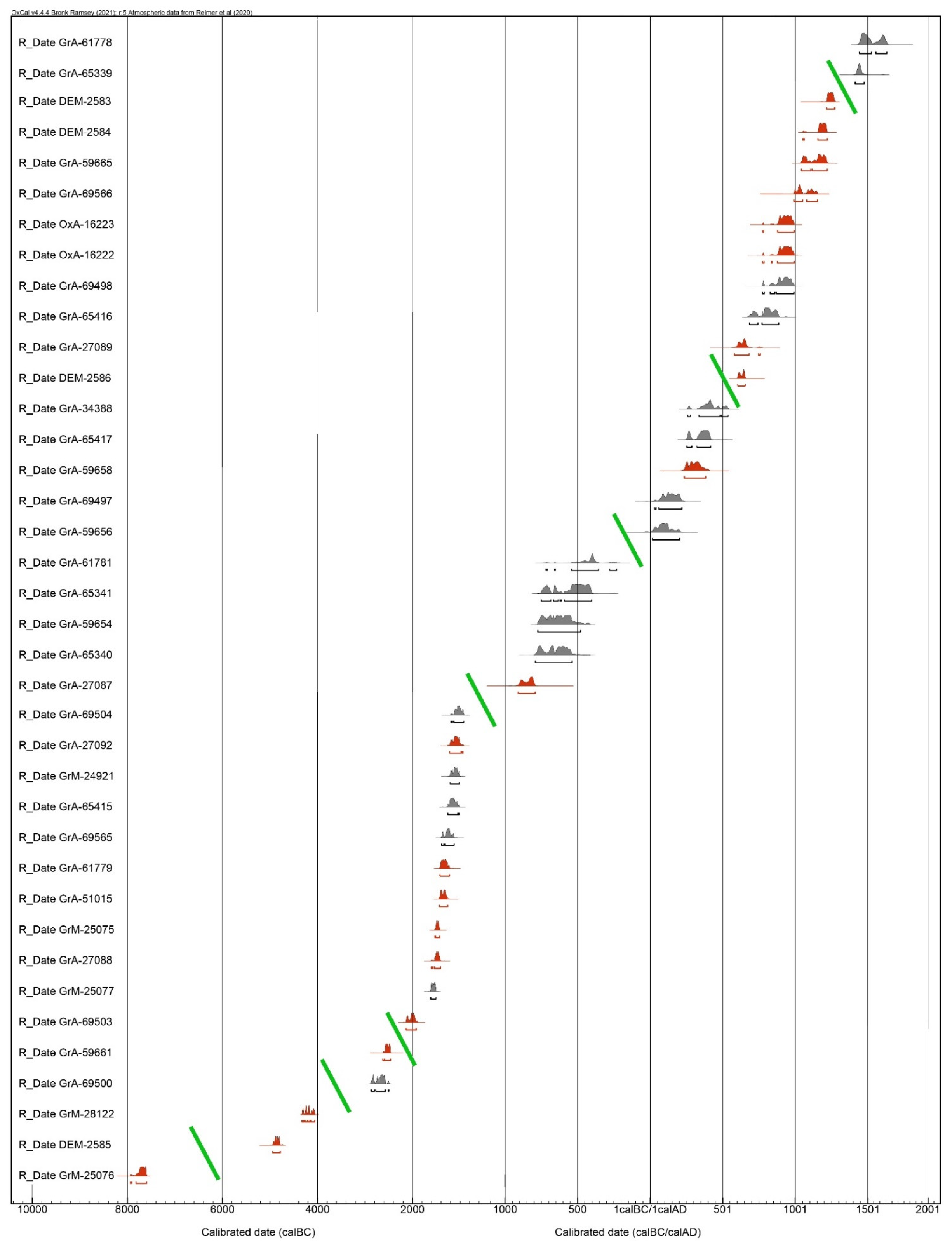
Figure 1. Map of the surveyed area showing the most important localities reported in the text, and the sites where test trenches were opened: Sam-8 (n. 1), Sam-5 (n. 2), Sam-29 (n. 3), Sam-23 (n. 4), and HC (n. 5) (drawing by P. Biagi).
Land 12 00096 g001
Figure 2. Distribution map of the radiocarbon-dated sites in the study area: HC-CH-20 (n. 1), BGD-1 (n. 2), NTS-25 (n. 3), Sam-23 (n. 4), SMX-1 (n. 5), Sam-8/2 and 8/4 (n. 6), KRN-45 (n. 7), Sam-29 (n. 8), AA-1 (n. 9), Sam-8/1 and 8/3 (n. 10), GRG-1 (n. 11), Samarina HC-5 and HC-4/CH1 (n. 12), Sam-5 (n. 13), VSL-1 (n. 14), SMR-1W (n. 15), and GVL-1 (n. 16). Mesolithic (white dot), Neolithic (blue dot), Chalcolithic (yellow dot), Bronze Age (red dot), Historical periods (violet dot). The white rectangle marks the location of the Historical Camp (HC) (top). Distribution map of the radiocarbon-dated tree-pits in the Historical Camp (HC): HC-102 (n. 1), HC-CH16 (n. 2), HC-115 (n. 3), HC-145 (n. 4), HC-CH9 (n. 5), HC-111 (n. 6), HC-144 (n. 7), HC-5/CH2 (n. 8), HC-146 (n. 9), CHR-4 (n. 10), CH-3 (n. 11), HC-105 (n. 12), HC-147 (n. 13), Grevena-1 (n. 14), HC-143 (n. 15), HC-107 (n. 16), HC-133 (n. 17), and CHR-5 (n. 18). Chalcolithic (yellow dot), Bronze Age (red dot), Iron Age (blue dot), Roman Age (white dot), Byzantine period (green dot), Medieval period (violet dot) (bottom) (drawings by P. Biagi and E. Starnini).
Land 12 00096 g002
Figure 3. Plot of all the calibrated dates from the Samarina highlands. Grey histograms: HC tree-pits, red histograms: archaeological sites. The oblique green bars mark the discontinuity between different periods. Calibrations according to OxCal 4.4 [26].
Land 12 00096 g003
Figure 4. Lake Gomara, along the southern slope of Mount Baltoumis (top), and location of the pre-core of Vikos “black chert” recovered from the surface ca. 200 m west of the small basin (red dot) (bottom) (photographs by E. Starnini, 2022).
Land 12 00096 g004
Figure 5. Mount Anitsa: bifacial rough-out (NTS-77) and debitage microflakelets of the same variety of non-local Vikos “black chert” (n. 1). The NTS lithic manufacturing spot has been radiocarbon dated to 5356 ± 26 BP (GrM-28122: NTS-25) by one Fraxinus charcoal fragment. Geological samples of Vikos “black chert” from the Vikos Gorge outcrops in Epirus (n. 2) (photographs by E. Starnini, 2022).
Land 12 00096 g005
Figure 6. Non-local artefacts made from Vikos “black chert” from different sites: GRG-125 (n. 1), GRG-46 (n. 2), GRG-121 (n. 3), GRG-156 (n. 4), GRG-39 (n. 5), GRG-144 (n. 6), Anitsa-74 (n. 7: microbladelet core), and VSL-305 (n. 10: microflakelet core or preform of a bifacial point), and blonde non-local chert SMC-13 (n. 8: hafted, long-end scraper used for cutting vegetation (CV), VSL-263 (n. 9: straight perforator heavily worn and broken) (photographs by E. Starnini).
Land 12 00096 g006
Figure 7. Triangular, barbed-and-tanged arrowheads with flat invasive or covering bifacial retouch from Kirkuri (KRK-28, n. 1), Sam-8 (n. 2), Mirminda Pass (VLC-1, n. 7); hollow-based arrowhead from Kirkuri (KRK-118, n. 3); fragments of arrowheads from Kirkuri (KRK-14, n. 4; KRK-92, n. 6) and the Mirminda Pass (VLC-10, n. 8); proximal fragment of dagger obtained by flat, covering bifacial retouch from Sam-8 (n. 5) (photographs by E. Starnini; drawings by P. Biagi; inking by G. Almerigogna).
Land 12 00096 g007
Figure 8. Unretouched obsidian flakelets from Melos Demenegaki (GRG-19, n. 1) and Carpathian 1b, Cejkov (VSL-139, n. 2) (bottom), and locations of the two obsidian outcrops (Carpathian 1, n. 2; Melos, n. 3). The green dot marks the location of the Vikos Gorge mentioned in the text; the white dot shows the location of Samarina (top) (photographs by E. Starnini; drawings by P. Biagi; inking by G. Almerigogna).
Land 12 00096 g008
Figure 9. Polished greenstone chisels from Mount Vasilitsa (VSLA-61: n. 1) and Sam-8 (n. 2) (photographs by E. Starnini).
Land 12 00096 g009
Figure 10. Distribution map of the prehistoric sites discovered in the Vasilitsa Pass (VSL 4 and VSL 5: nn. 4 and 5), along the northern slope of Mount Baltoumis (VSL 1, VSL 2 and VSLA: nn. 1–3), and Lake Smixi (nn. 6–8) (top). Lake Smixi location of the finds: refitting Levallois flakes (n. 1), Mousterian discoid cores and pre-core (n. 2), Upper Palaeolithic retouched point (n. 4), early Bronze Age small pit radiocarbon-dated to 3645 ± 35 BP (GrA-69503: SMX-1) from one pine charcoal fragment (n. 5) (bottom). The white dots and the triangle refer to the Palaeolithic artefacts, the red dot to the Bronze Age pit (drawing by P. Biagi).
Land 12 00096 g010
Figure 11. Agios Athanasios: Sampling charcoal from a profile exposed by erosional processes within the Bronze Age site (AA) located on a terrace of the Venetikos River Valley, which yielded the result of 3070 ± 40 BP (GrA-61779: AA-1) (photograph by P. Biagi, 2014).
Land 12 00096 g011
Figure 12. Distribution map of all the Palaeolithic and Holocene knapped stone artefacts collected in 2008 along the northern slopes and ridge of Mount Bogdani (yellow dots). The orange dot marks the location of the Melos obsidian flakelet (GRG-19), the red dot the Late Neolithic fireplace BGD-1, which was radiocarbon-dated to 5972 ± 27 BP (DEM-2585) (drawing by C. Franco and P. Biagi).
Land 12 00096 g012
Figure 13. Geomorphological map of the Mount Vasilitsa area. The stratigraphical units marked (ad) represent the Vasilitsa Formation: (a) Smixi Member, (b) North Vasilitsa Member, (c) Central Vasilitsa Member, (d) Vasilitsa Summit Member. The stratigraphic unit marked (e) represents the East Vasilitsa Member, the sole unit of the East Vasilitsa Formation (drawing by P. Hughes).
Land 12 00096 g013
Figure 14. A section through the Smixi Member moraines at ca. 40°03′10″ N, 21°05′50″ E, 1690 m a.s.l. Note the large boulders on the surface of the moraine, which are a common feature in this area (left). A moraine impounding a lake to the east of Mount Vasilitsa at ca. 40°02′52″ N, 21°05′40″ E, 1790 m a.s.l. (right) (photographs by P. Hughes, May 2003).
Land 12 00096 g014
Figure 15. Panoramic view of the archaeological sites discovered along the northern slopes of Mount Baltoumis: VSL 1 (top), and VSL 2 with Mount Anitsa in the background (bottom) (photographs by P. Biagi, 2019).
Land 12 00096 g015
Figure 16. Mount Vasilitsa: Holocene knapped stone artefacts made from non-local chert: Site VSL 1: Flat-retouched side scraper (n. 1), bifacial arrowhead (n. 2), short end scraper (n. 3), flat-retouched bladelet (n. 4), proximal fragment of flat-retouched, bifacial dagger (VSL-285, n. 5) and artefacts with utilisation traces (VSL-190, cut hide (Chi), n. 6; and VSL-184, cut wood (CW), n. 7) (photographs by E. Starnini).
Land 12 00096 g016
Figure 17. Sickle inserts from various localities: Mount Anitsa: hafted, snapped, abrupt-retouched bladelet with opposed oblique sickle gloss (Si), of reddish-brown radiolarite (Anitsa-130, n. 1); Mount Baltoumis: flat-retouched, bifacial insert of radiolarian chert (VSL-211, n. 2); Mount Baltoumis: hafted, flat-retouched, bifacial sickle insert (Si) with notched, resharpened working edge, hafted and reshaped, made of radiolarian chert (VSL-181, n. 3); Mirminda Pass, flat-retouched, bifacial insert with sickle gloss (Si) (VLC-32, n. 4); fragment of bifacial dagger (Sam-33, n. 5); unretouched bladelet with sickle gloss (Si) (Sam-23, n. 6) (photographs by E. Starnini; drawings by P. Biagi, inking by G. Almerigogna).
Land 12 00096 g017
Figure 18. Different types of non-local chert geometric microliths from different sites: VSL-145 (n. 1: Vikos “black chert”: wear traces: cut hard (CH), (a); hafting, (b), VSL-526a (n. 2: Vikos “black chert”), VLC-93 (n. 3: Vikos “black chert”), Sam-23 (n. 4), NTSW-4 (n. 5), Sam-11 (n. 6), and KRK-88 (n. 7); non-local chert arrowheads from Mount Anitsa northern upper slope (Anitsa-26: n. 8; Anitsa-111, n. 9; Anitsa-207, n. 10) (photographs by E. Starnini; drawings by P. Biagi; inking by G. Almerigogna).
Land 12 00096 g018
Figure 19. Flat-retouched, unifacial point from Mount Baltoumis Site 3 (VSLA-48, n. 1) made from non-local chert, hafted long-end scraper with scrape hides (Shi) traces of wear made from non-local blonde flint (VSL-95, n. 2), hafted long-end scraper with scrape wood (SW) traces of wear made from non-local blonde flint (VSL-162, n. 3), cylindrical soapstone bead with unfinished, bidirectional perforations, broken, during manufacture, from Mount Baltoumis Site 1 (VSL-318, n. 4), and bifacial artefact with scrape hard (SH) wear traces from Sam-8 (n. 5) (photographs by E. Starnini).
Land 12 00096 g019
Figure 20. Lake Smixi: Middle Palaeolithic, Levallois refitting flakes (nn. 1–4) and discoid cores made from local chert (nn. 5 and 6) from the Smixi Member moraines south of the small basin (photographs by E. Starnini).
Land 12 00096 g020
Figure 21. Lake Smixi: Middle Palaeolithic pre-core (n. 1) and probable Upper Palaeolithic point on a blade (n. 2) made from local chert (photographs by E. Starnini).
Land 12 00096 g021
Figure 22. The top of Mount Kirkuri from the south, from which come lithic artefacts of different cultural periods and Bronze Age arrowheads (photograph by E. Starnini, 2013).
Land 12 00096 g022
Figure 23. Historical Camp (HC): views from the lower slopes on Mount Gurguliu. Note Mount Kirkuri in the background and the location of the HC site excavation trench along the edge of the erosion gully, in the centre of the top photograph. Mount Kirkuri is visible in the background (photographs by P. Biagi, 2006).
Land 12 00096 g023
Figure 24. Historical Camp (HC): excavations underway in the seventh-century AD site. The 2 × 3 m test trench (a), inclined posthole (b), shallow burning pits or fireplaces with charcoals of small juniper branches (c,d), the second of which has been radiocarbon-dated to 1414 ± 18 BP (DEM-2586) (photographs by P. Biagi, 2006).
Land 12 00096 g024
Figure 25. Historical Camp (HC): the excavation carried out at pine tree-pit HC-5 which was radiocarbon-dated to 2485 ± 30 BP (GrA-59654) (photographs by P. Biagi, 2010).
Land 12 00096 g025
Table 1. List of all the radiocarbon-dated sites reported in the text. The HC tree-pit results are marked in grey (NA = Not Available). Calibrations according to OxCal 4.4.
ReferenceContextCoordinatesAltitude (m)Laboratory NumberUncal BPTaxonCal BC/AD (95.4%)Δ13CFigure
CHR-5tree-pit40°06′42.7″ N–21°00′24.9″ E1547GrA-61778385 ± 35Fagus sylvatica1443–1663 AD−25.73 ± 0.152 bottom, n. 18
HC-133tree-pit40°06′52.1″ N–21°00′14.5″ E1528GrA-65339455 ± 30Pinus nigra1414–1475 AD−25.352 bottom, n. 17
GVL-1colluvial charcoal40°07′20.1″ N–20°59′32.3″ E1531DEM-2583805 ± 21Quercus sp.1218–1271 ADNA2 top, n. 16
SMR-1Wcharcoal horizon40°07′31.9″ N–20°59′53.6″ E1522DEM-2584876 ± 19Fagus sylvatica1053–1222 ADNA2 top, n. 15
HC-4/CH1burning pit?40°06′41.1″ N–21°00′33.1″ E1536GrA-59665895 ± 30Juniperus sp.1043–1220 AD−26.7652 top, n. 12
VSL-1fireplace40°04′12.4″ N–21°04′19.9″ E1774GrA-69566995 ± 30Pinus nigra992–1154 AD−23.85 ± 0.112 top, n. 14
Sam-5/1fireplace40°08′10.4″ N–21°00′53.5″ E1778DEM-1918/OxA-162231127 ± 25undet. charcoal775–994 AD−26.72 top, n. 13
Sam-5/2fireplace40°08′10.4″ N–21°00′53.5″ E1778DEM-1917/OxA-162221129 ± 26undet. charcoal775–994 AD−24.12 top, n. 13
HC-107tree-pit40°06′41.8″ N–21°00′31.3″ E1541GrA-694981140 ± 30Pinus nigra774–992 AD−23.75 ± 0.112 bottom, n. 16
HC-143tree-pit40°06′41.9″ N–21°00′31.3″ E1552GrA-654161225 ± 30Pinus nigra671–876 AD−24.272 bottom, n. 15
Sam-8/3colluvial charcoal40°08′10.7″ N–20°00′22.0″ E1782GrA-270891395 ± 40Pinus nigra580–759 AD−22.602 top, n. 10
Samarina HC-5burning pit40°06′41.3″ N–21°00′33.9″ E1567DEM-25861414 ± 18Juniperus sp.604–655 ADNA2 top, n. 12
Grevena-1tree-pit40°06′41.5″N–21°00′37.5″ E1524GrA-343881655 ± 35undet. charcoal260–537 AD−21.542 bottom, n. 14
HC-147tree-pit40°06′42.1″ N–21°00′29.6″ E1547GrA-654171700 ± 30Pinus nigra254–419 AD−24.022 bottom, n. 13
GRG-1small kiln40°05′33.4″ N–20°59′55.1″ E1939GrA-596581755 ± 30Pinus sylvestris236–384 AD−23.1362 top, n. 11
HC-105tree-pit40°06′42.2″ N–21°00′31.4″ E1540GrA-694971905 ± 30Pinus heldreichi31–219 AD−27.96 ± 0.112 bottom, n. 12
CH-3tree-pit40°06′42.2″ N–21°00′31.2″ E1546GrA-596561935 ± 30Pinus sp.17–205 AD−25.07 ± 0.15 2 bottom, n. 11
Chr-4/CHR-4tree-pit40°06′42.2″ N–21°00′29.8″ E1544GrA-617812340 ± 40Pinus nigra718–232 BC−26.61 ± 0.152 bottom, n. 10
HC-146tree-pit40°06′42.2″ N–21°00′30.0″ E1548GrA-653412430 ± 35Pinus nigra751–404 BC−22.642 bottom, n. 9
HC-5/CH2tree-pit40°06′42.0″ N–21°00′31.0″ E1548GrA-596542485 ± 30Pinus sp.774–481 BC−23.3252 bottom, n. 8
HC-144tree-pit40°06′41.9″ N–21°00′31.1″ E1550GrA-653402515 ± 35Pinus nigra791–589 BC−23.792 bottom, n. 7
SAM-8/1colluvial charcoal40°08′10.7″ N–20°00′22.0″ E1782GrA-270872680 ± 40Salix sp.909–793 BC−24.812 top, n. 10
HC-111tree-pit40°06′42.1″ N–21°00′30.5″ E1542GrA-695042860 ± 35Pinus nigra1187–919 BC−23.20 ± 0.112 bottom, n. 6
SAM-8/4colluvial charcoal40°08′10.7″ N–20°00′22.0″ E1782GrA-270922900 ± 40Abies sp.1218–937 BC−27.082 top, n. 6
HC-CH9tree-pit40°06′45.0″ N–21°00′22.9″ E1546GrM-249212912 ± 26Pinus nigra1205–1015 BC−24.67 ± 0152 bottom, n. 5
HC-145tree-pit40°06′42.2″ N–21°00′30.7″ E1552GrA-654152940 ± 35Pinus nigra1260–1017 BC−23.372 bottom, n. 4
HC-115tree-pit40°06′42.1″ N–21°00′29.9″ E1542GrA-695653010 ± 35Pinus nigra1389–1125 BC−23.31 ± 0.112 bottom, n. 3
AA-1charcoal horizon40°07′45.0″ N–21°07′07.1″ E1112GrA-617793070 ± 40Quercus caducifolia1423–1223 BC−23.81 ± 0.152 top, n. 9
Sam-29, Anitsacharcoal40°05′36.5″ N–21°05′09.8″ E1705GrA-510153095 ± 35Quercus sp.1436–1264 BC−25.76 ± 0.152 top, n. 8
KRN-45charcoal lens40°05′05.0″ N–21°10′16.0″ E1333GrM-250753218 ± 26Quercus sp.1528–1430 BC−23.96 ± 0.152 top, n. 7
Sam-8/2colluvial charcoal40°08′10.7″ N–20°00′22.0″ E1782GrA-270883220 ± 40Fagus sp.1607–1414 BC−23.612 top, n. 6
HC-CH16tree-pit40°06′40.8″ N–21°00′32.5″ E1537GrM-250773297 ± 26Pinus nigra1618–1507 BC−26.74 ± 0.152 bottom, n. 2
SMX-1charcoal from pit40°03′41.4″ N–21°06′50.1″ E1367GrA-695033645 ± 35Pinus sp.2137–1923 BC−23.15 ± 0.112 top, n. 5
Sam-23, Anitsacharcoal horizon40°05′44.0″ N–21°04′53.6″ E1666GrA-596614005 ± 35Juniperus sp.2623–2461 BC−23.2282 top, n. 4
HC-102tree-pit40°06′43.1″ N–21°00′31.8″ E1541GrA-695004105 ± 35Pinus nigra2868–2501 BC−26.95 ± 0.112 bottom, n. 1
NTS-25, Anitsacharcoal40°05′33.0″ N–21°05′08.0″ E1704GrM-281225356 ± 26Fraxinus sp.4325–4055 BC−25.73 ± 0.152 top, n. 3
BGD-1fireplace40°07′26.9″ N–20°58′36.8″ E1892DEM-25855972 ± 27undet. charcoal4944–4783 BCNA2 top, n. 2
HC-CH20tree-pit?40°06′46.3″ N–21°00′19.8″ E1546GrM-250768705 ± 35Salix sp.7934–7596 BC−26.20 ± 0.152 top, n. 1
HC-CH18tree-pit40°06′46.2″ N–21°00 19.5″ E1546failed, too small sampleNAPinus sp.NANANA
HC-149tree-pit40°06′51.8″ N–21°00 17.3″ E1532failed, too small sampleNAPinus nigraNANANA
HC-148tree-pit40°06′52.4″ N–21°00 16.8″ E1532failed, too small sampleNAPinus nigraNANANA
Table 2. Chronostratigraphy and morpho-lithostratigraphy of the moraine sequence in the north-eastern valley of Mount Vasilitsa. From Hughes (2004).
Chronostratigraphy/AgeMorpho-Lithostratigraphy (Moraine Sequence)
Tymphian Stage, MIS 5d-2
110,000–11,700
Unit 3Vasilitsa Summit Member
East Vasilitsa Member
VASILITSA &
EAST VASILITSA FORMATIONS
Vlasian Stage, MIS 6a
190,000–130,000 years ago
Unit 2North Vasilitsa Member
Central Vasilitsa Member
Skamnellian Stage, MIS 12
480,000–430,000 years ago
Unit 1Smixi Member
Disclaimer/Publisher’s Note: The statements, opinions and data contained in all publications are solely those of the individual author(s) and contributor(s) and not of MDPI and/or the editor(s). MDPI and/or the editor(s) disclaim responsibility for any injury to people or property resulting from any ideas, methods, instructions or products referred to in the content.

