Article

Modelling and Assessing Sustainable Urban Regeneration for Historic Urban Quarters via Analytical Hierarchy Process

1
Faculty of Architecture, Near East University, via Mersin 10, Nicosia 99138, North Cyprus, Turkey
2
Faculty of Architecture and Fine Arts, Final International University, via Mersin 10, Kyrenia 99320, North Cyprus, Turkey
*
Author to whom correspondence should be addressed.
Land 2023, 12(1), 72; https://doi.org/10.3390/land12010072
Submission received: 21 November 2022 / Revised: 19 December 2022 / Accepted: 22 December 2022 / Published: 26 December 2022
(This article belongs to the Topic Sustainability in Heritage and Urban Planning)

Abstract

:
The push for urban development and the rapid increase in population have left many historic urban cores vulnerable and subject to deterioration. SDG-11 is often mentioned as the goal in UNDP regeneration, revitalization, and preservation projects regarding historic urban sites around the globe. The goal emphasizes 10 targets that are complex in nature and require closer inspection regarding their interconnectedness when being utilized in real-world scenarios. The current study explores the complexities of the decision-making process in planning urban regeneration projects concerning targets of SDG-11. The study uses a Multi-Criteria Evaluation (MCE) method to investigate how and to what significance the targeted criteria were used in planning for two UNDP urban regeneration project zones in Cyprus. These cases have a complex cultural and socio-political dynamic and pose high contextual significance for the region; therefore, many of these targets are critical in achieving more sustainable regeneration projects. The data collection was done by critically examining the projects’ documentation and conducting interviews with experts involved in the two projects. The data is controlled for internal consistency and anomalies. The study makes its case by comparing the different approaches implemented in these two projects and how effective they were in achieving SDG-11 targets.

1. Introduction

The increasing population of the world and the influx of people into the cities make them central in planning for the future of humanity [1,2]. The United Nations proposed 17 goals within the framework of Agenda 2030 to make the development process more sustainable in the future [3]. Goal 11, perhaps the most spatial among these, directly targets various dimensions of cities. This goal aims to make cities more resilient, inclusive, safe, environmentally friendly, and protective of their heritage [4]. Nevertheless, keeping the balance between sustainable development and the preservation of heritage is a challenging endeavor that requires innovative methodological approaches capable of addressing the multifaceted nature of the problem from both perspectives [5].
The SDGs are often interconnected and cannot be achieved individually. The goals have an air of abstraction for the most part and lack an empirical action plan. They are often perceived as general guidelines or directions to move toward [6]. It seems that having a standardized metric to evaluate the success rate of moving toward the SDGs should be considered [7]. SDGs are general guidelines; thus, a significant problem associated with them is the lack of empirical solutions or, rather, ambiguities in how empirical solutions at a local scale can be achieved.
The influx of population makes planning for accommodation critical in urban settlements [8]; this often happens in three forms: new residential units, regeneration of existing urban tissue, or informal settlements. In this regard, people’s participation is an essential dimension of urban regeneration planning and policymaking [9]. Successful urban regeneration requires a balance between development and preservation [10]. Valencia et al. [11] state that “political will, coherent governance, and strong formal partnerships between the public sector, private sector, and civil society actors are key ingredients in achieving goals such as the SDGs.” Bottom-up approaches that take into account the local residents’ views and community-based frameworks are essential for sustainable and healthy regeneration practices [12]. The success of SDGs is dependent on the locality of their implementation strategies and how they affect the everyday lives of people [13]. This is especially critical as the vulnerable residential population is often most affected by regeneration plans that might have been designed with clear sustainability goals but without considering their needs [14]. The strive for sustainable development must not become a burden on lower social strata; instead, it needs to involve those people in the decision-making process [12].
Although Goal 11 targets cities and their attributes, the scholarly literature seems to be lacking in terms of addressing the interdisciplinary nature of urban regeneration with regard to the goal. It is evident that while tangible dimensions such as carbon emissions, materials, and climate have been thoroughly investigated [15], bottom-up urban design practices and the intrinsic socio-spatial quality of urban spaces seem not to be well defined within the framework of this goal. Many of these dimensions have been studied in urban design for decades outside the framework of SDGs, but moving toward seeing urban design frameworks through the lens of SDGs seems to be an inevitable necessity. The current paper focuses on the regeneration of historic urban quarters concerning Goal 11. The paper addresses the shortcomings of Goal 11 in providing tangible guidelines for the reality of urban design and planning practices. Furthermore, the relationship between local stakeholders and other institutional bodies is not well defined in Goal 11. The paper does not aim to address all indicators of Goal 11 targets, but rather explores contextual circumstances that might not fit within the overgeneralization of Goal 11 by including different involved parties. This process is conducted by superimposing the data associated with different targets and is often difficult to overlap. Therefore, the study aimed to utilize a Multi-Criteria Evaluation (AHP in this case) suitable for exploring a goal while addressing a multitude of data sources.

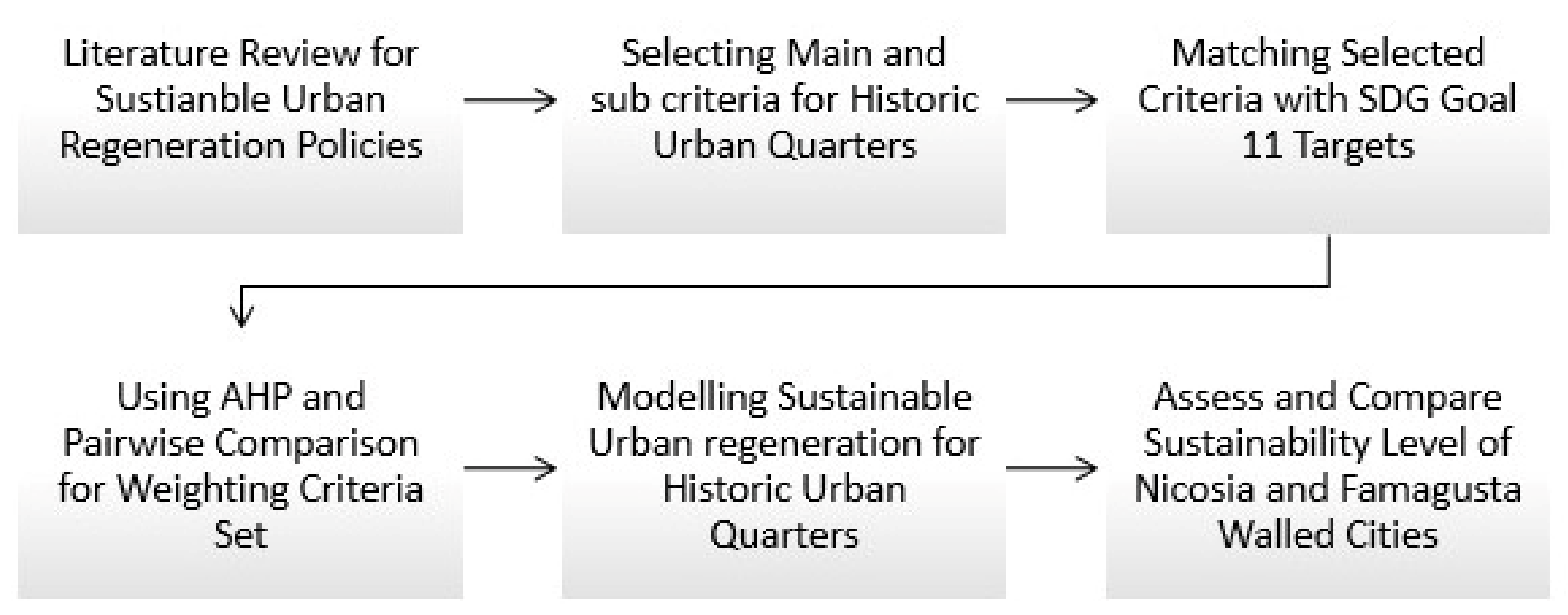
2. Material and Methods

Sustainable urban regeneration (SUR) is an intricate task for real-world project management and implementation. SDG-11 further adds to these complexities by introducing numerous long and short-term targets. Therefore, it seems critical to divide the goal into manageable criteria and sub-criteria relevant to the circumstances of the site and in line with the existing body of literature. Therefore, SUR can benefit from utilizing multi-criteria evaluation processes capable of addressing its natural intricacies. Additionally, this multi-criteria evaluation should be adopted for SDG-11 and targets historic urban quarters. Different case studies and literature reviews were realized, and criteria and sub-criteria packages were matched with targets (see Figure 1). Moreover, the lack of institutional transparency and urban data is one of the biggest obstacles when aiming for SDGs [16]; this is particularly problematic in less developed regions that are more in need of such approaches.
Urban regeneration programs are not mere spatial or physical interventions; they require the involvement of many different layers of data (e.g., social, cultural, economic, and historic). Furthermore, they require both top-down and bottom-up participation [17]. Accordingly, selecting a methodological approach that can receive input from different sources is critical. Multi-Criteria Evaluation (MCE) methods are strong tools in urban planning and regeneration, especially when the involvement of different parties, stakeholders, and data layers is required [18,19]. Utilization of MCE methods in approaching SDGs can potentially create a more comprehensive and successful empirical workflow [20]. MCE can be implemented in SUR to better understand the weights and priorities of intervening criteria, especially when future planning requires active modification or when the transformation of local contextual attributes transforms the plan [21]. The novelty of the study is exploring a new approach by using AHP for SDG-11 goals and targets, constructing a hierarchy for modelling, and measuring the sustainability level of urban regeneration activities within historical and cultural urban environments (see Figure 2).
Although SDG-11 has been used at the neighborhood level [22,23], urban regeneration policies and activities were not investigated within the SDG targets. The overlaying of different opinions and data layers generated by different parties is also a nuance of the current study.

2.1. Multi-Criteria Evaluation (MCE)
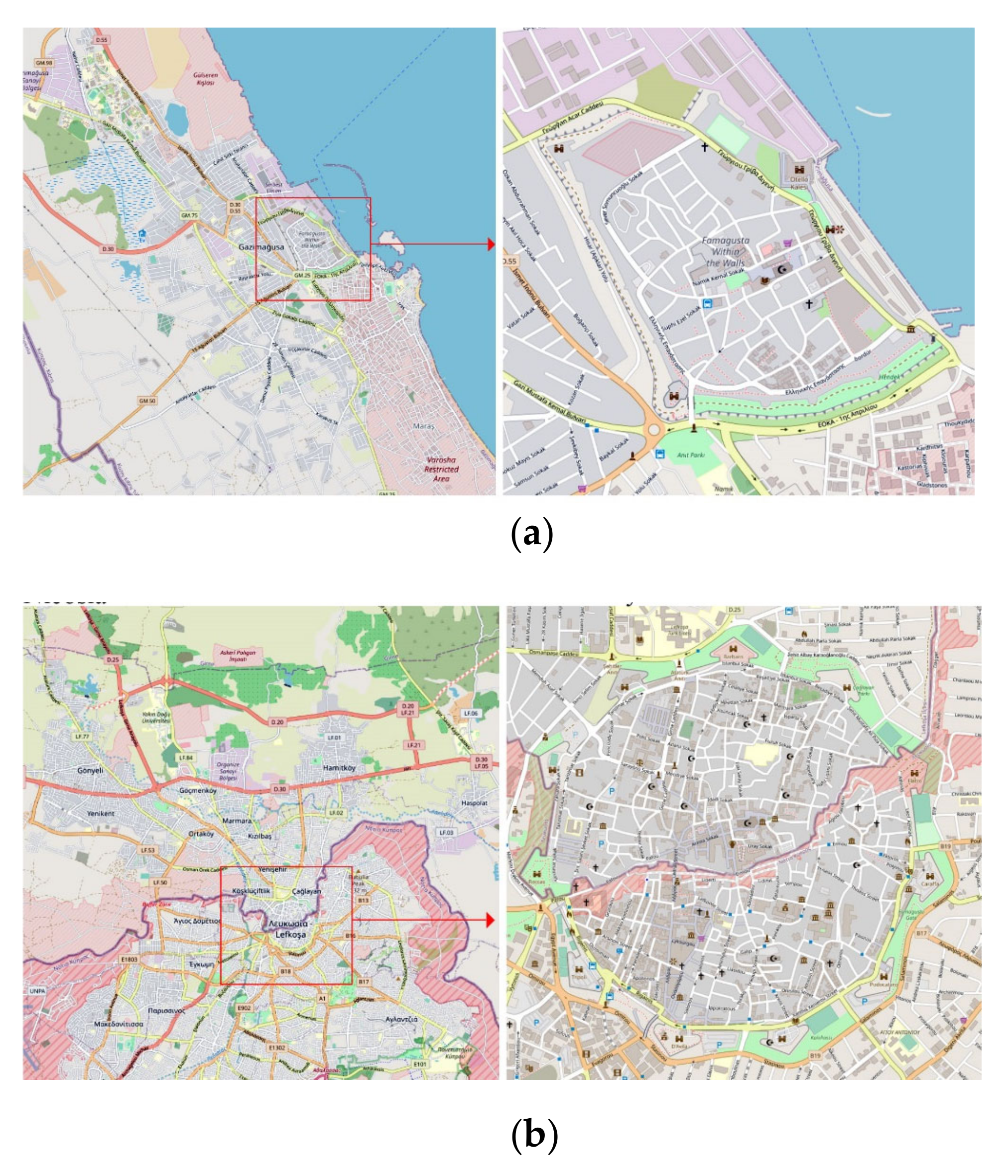
Multi-criteria evaluation methods (also known as multiple-criteria decision-making (MCDM)) are a set of methods designed to provide a logical workflow for decision-making when there are numerous (sometimes even conflicting) influential criteria [24]. MCE makes the process of decision-making in addressing problems of high complexity more informed and explicit [25,26].
When complex interconnected factors are present, the integration of MCE methods within the GIS workflow allows for more comprehensive decision-making [27,28,29]. The implication of MCE methods for urban regeneration and decision-making has a strong precedent in the literature [30,31,32], and this is more evident for sites of cultural heritage [33,34,35]. The Analytic Hierarchy Process (AHP) is among the most utilized MCE methods, first introduced by Saaty. The model is constructed by defining a goal that aims to select the best alternatives from a set of possible outcomes, followed by identifying criteria and possible sub-criteria. All criteria are then compared against one another using a pairwise matrix. Weighted criteria are then cross-referenced with the alternatives [36]. The pairwise comparison is usually done via a survey, but it can be achieved via other means of data analysis. The utilization of GIS in AHP modelling has been gaining traction and showing promising results [37,38]. Using GIS to support the weighing criteria is particularly useful in large urban settings due to the sheer number of influential criteria [39]. What is more, the fact-based nature of GIS might improve some shortcomings of surveys, such as a lack of consensus among experts or addressing a large number of evaluation criteria [40].
The process of conducting AHP analyses is often performed in five steps: setting up a goal, criteria, or sub-criteria, and an alternative, pair-wise comparison of criteria or sub-criteria with respect to the goal; constructing a comparison matrix; analyzing the weight of variables derived from the comparison matrix; and checking for potential inconsistencies via the measure of Consistency Ratio (CR). CR is calculated by using the Consistency Index/ Random Index (CR: for more details, consult [41,42,43]).

2.2. Study Area

The paper explores two case studies: the walled city of Famagusta (also known as Gazimağusa, Figure 3a) and the walled city of Nicosia (also known as Lefkoşa, Figure 3b). Both cities have rich historic tissue, a large portion of which is located within the boundaries of the historic fortifications.

2.2.1. Famagusta

The growth of Famagusta has been influenced by a variety of social, economic, and cultural intervening factors. The conflict of 1974, which bordered a significant part of the city, and the establishment of the Eastern Mediterranean University motivated the growth of the city toward the university campus and away from the walled city [44,45]; these circumstances have left the walled city less connected to the rest of the urban grid and prone to deterioration [46]. Original regeneration strategies proposed for the historic walled city followed the traditional sustainability triad of economic, social, and environmental factors [44,47]. Nevertheless, the integration of Agenda 2030 and the SDGs has not been fully explored in these renewal processes.

2.2.2. Nicosia

The walled city of Nicosia, similarly, has a rich history and has evolved and expanded over time [48]. Similar to Famagusta, the city has been divided after the conflict of 1974, with the buffer zone (or green line) cutting through the middle of the historic walled city. Nevertheless, the city has a master plan that was produced by both sides after 1977 [49] and finalized in 1981 as a conjoined official document [50]. Preservation, regeneration, and rehabilitation of historic tissue were central to the development of the Nicosia master plan, taking into account the complex intricacies of the two parts’ economic, political, and cultural divides [51]. According to Tsolaki et al. [52], the Nicosia master plan regards regeneration strategies aiming to achieve social, economic, and architectural objectives. Although the master plan is a great undertaking, it has some shortcomings in considering administrative, environmental, and local stakeholders.

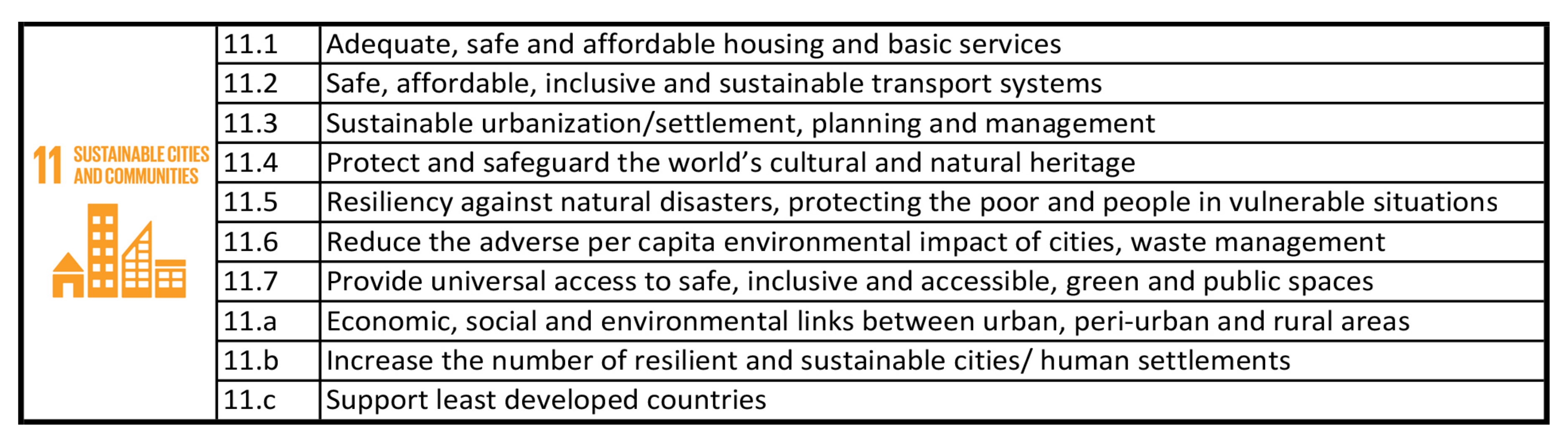
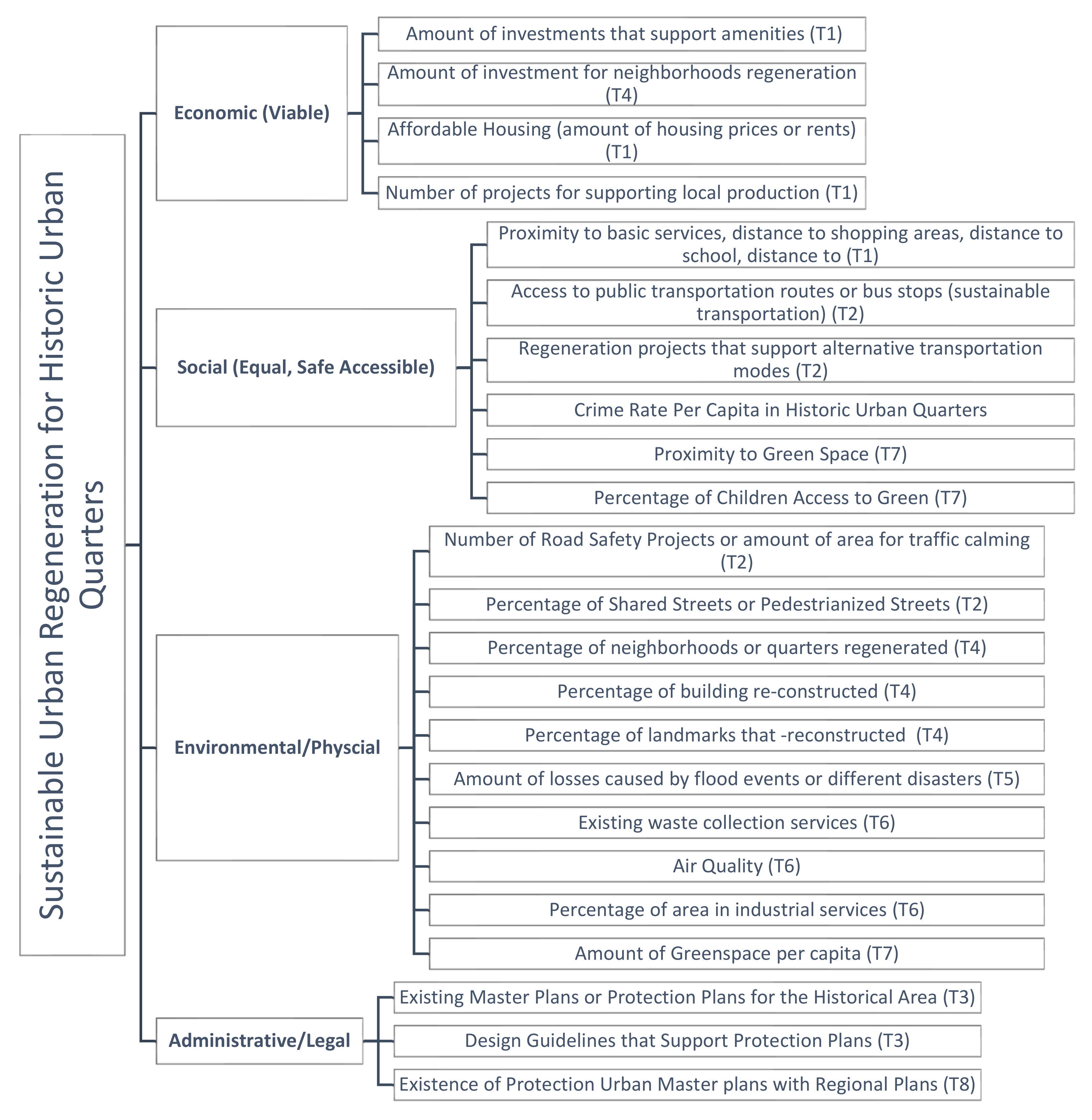
2.3. Selection of Criteria/Alternatives

The current study explores the multidimensional complexity of establishing a comprehensive practice for sustainable urban regeneration in areas with historic tissue. Accordingly, the goal of the study was to determine a more successful site in terms of “sustainable urban regeneration in historic urban quarters.” The alternatives in this study refer to the two cases, the walled cities of Nicosia (northern section) and Famagusta, respectively.
Selection of the criteria and sub-criteria is often conducted by addressing the relevant body of literature and the circumstances of the sites [53]. There exist numerous approaches regarding the selection of criteria concerning the preservation and regeneration of historic environments [5,54,55,56]. The current study approached the topic from the main criteria for sustainable development (economic, social, and environmental); the administrative/legal dimension was added later because it has a significant contextual impact on how the other three dimensions can be realistically implemented [57,58]. The selection process of the associated sub-criteria was motivated first by the targets of SDG-11, the existing literature, and contextual circumstances of the site (see Figure 4). Each sub-criterion is corresponding to one of the targets of Goal 11. Targets 11.b and 11.c are not included due to their international scope that cannot be addressed within the scale of the current case studies.

2.4. Evaluation of Criteria Weights

After the criteria are set, implementing pairwise comparisons with experts related to the topic is required. Experts from town planning, municipalities, antiquities, universities, and chambers were selected to fill the comparison tables for the main and sub-criteria. The target group included architects, urban planners, academicians, and managers, who compared the given criteria by using the model proposed by Saaty [26]. The weights were calculated for each criterion (Table 1). Consistency Ratio (CR) values were also controlled for each comparison and are within the acceptable threshold (<0.05).

3. Data Collection and Results

One of the most challenging aspects of the current study was the scope of data collection. Whereas in many regions public and transparent data on issues such as spending, occupation, taxes, subsidies, crime rates, and funded projects are available, in this case, similar to many other parts of the region, accessing detailed economic data is not feasible [59]. Even when available, the data are very general and lack necessary details suitable for AHP analysis. The current data sets addressing 24 sub-criteria for two alternatives were collected using police department reports, UNDP, municipalities, the antiquities department, the environment department, the town planning department, available GIS data, Open Street Map (OSM), existing literature, master plans, and housing market websites. It must be noted that AHP is especially helpful in these cases when the influencing factors are numerous, intricate, interrelated, from different sources, or even at odds with one another. [24,42,60]. This approach, coupled with the expert evaluation, ensures that the results address the intrinsic complexity of the topic from multiple perspectives.

3.1. Economic Dimension

Amount of investments that support amenities (T1): The economic sub-criteria were evaluated using different data collection methods. The amenities were evaluated based on their frequency as displayed on the Open Street Map (OSM) platform. OSM has proven to be a reasonably reliable image of the region’s public amenities [46]. The numbers were first adjusted for the area in each case before conducting a pairwise comparison. Northern Nicosia, due to its administrative dimension and centrality, contains more public amenities compared with Famagusta. Nevertheless, these amenities are not equally distributed across the area and are more focused on central parts and tourist attractions.
Amount of investment for neighborhood regeneration (T4): Neighborhood regeneration investments are more numerous in Northern Nicosia. Many neighborhood regeneration plans have been proposed and implemented over the last two decades within the framework of the Nicosia Master Plan, which is an ongoing effort to preserve Nicosia’s urban and architectural heritage regardless of its borders [49,51]. These projects in northern Nicosia included housing rehabilitation programs in Arabahmet, Samanbahce, and Selimiye [61]. Famagusta, on the other hand, has seen very limited investment for neighborhood regeneration, and the majority of the focus has been oriented toward more significant historical buildings and monuments [62]. Although small social housing units have been constructed on the northern side of the walled city by the municipality, the area lacks a clear plan for investing in neighborhood regeneration.
Affordable Housing (amount of housing prices or rents) (T1) and Number of projects for supporting local production (T1): Housing affordability was measured by exploring all available sales and rental options on the two major websites that are widely used in the region (23 cases in Nicosia and 14 cases in Famagusta). The collected prices were adjusted by area, and the averages were used for the comparison. The average price of housing is relatively higher in Famagusta (GBP 1029 per m2) compared to Nicosia (GBP 788 per m2), but the range of prices is much wider in Northern Nicosia (GBP 2228-246 per m2) compared to Famagusta (GBP 1400-418 per m2). What is more, the physical condition of housing in Northern Nicosia varies from neighborhood to neighborhood. For the criterion addressing local production, the number of workshops, shops, and non-governmental organizations supporting local production were counted and compared (adjusted for population). Nicosia, due to its centrality, higher tourist numbers, and its closeness to the border, has more activities associated with local production. Supporting local production and local involvement, which is an intrinsic dimension of Target 1, is a critical aspect of resilient neighborhood regeneration. Putting emphasis on mere physical improvement can create undesirable social side effects such as gentrification and unintentional displacement of the local population. Therefore, exploring the success of a regeneration plan needs to include intentions for the future stability of the social fabric.

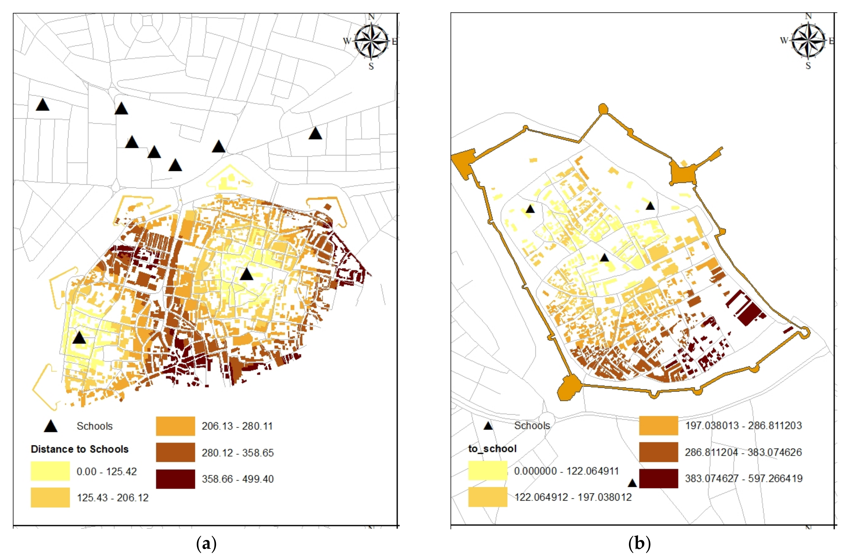
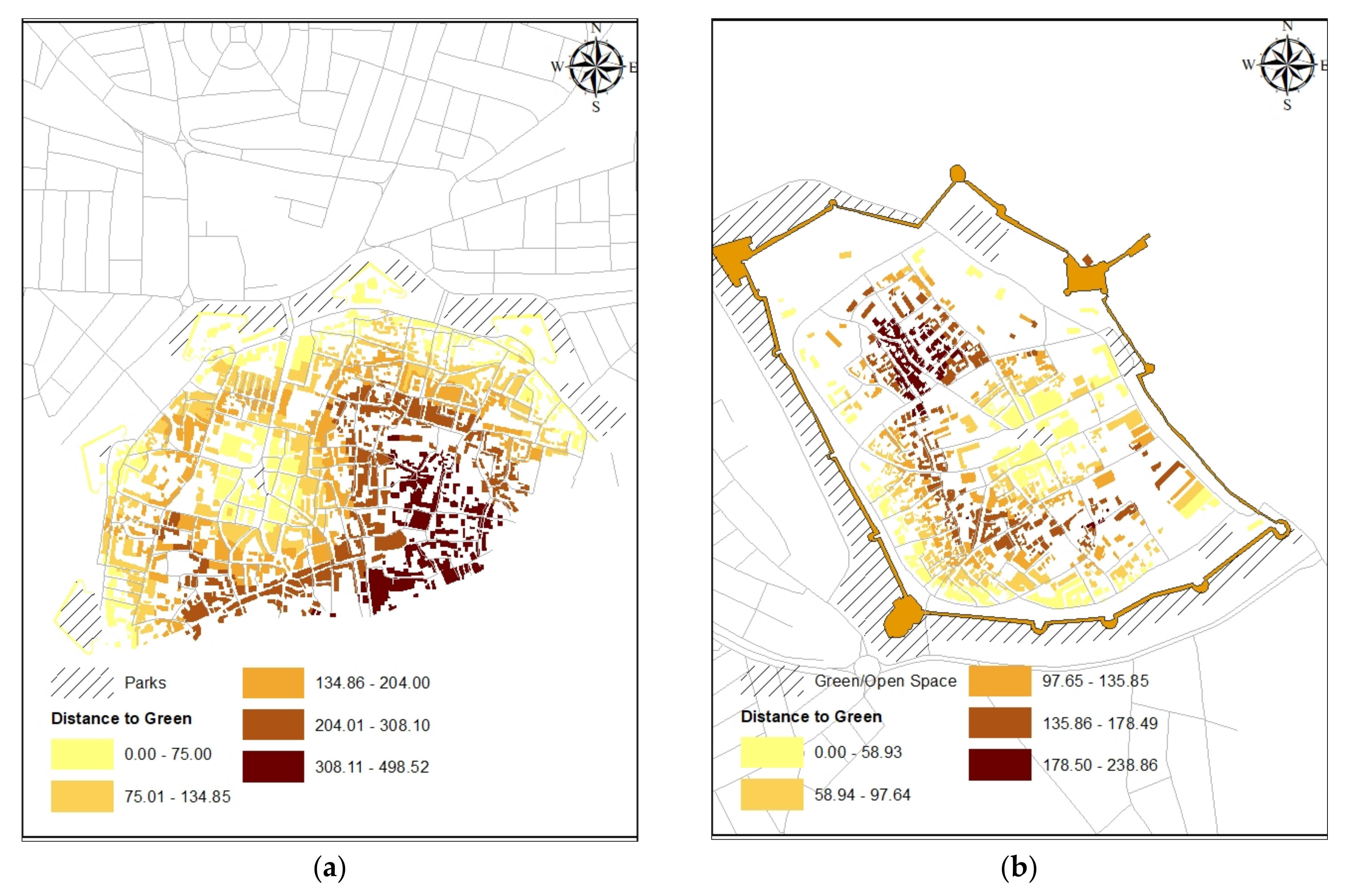
3.2. Social Dimensions

As with the economic dimension, each social sub-criteria value was obtained from different resources. Accessibility to basic services and green spaces was analyzed in a GIS environment by using the near distance tool. Within the historical environments, the distances from schools, markets, and green spaces were calculated (see Figure 5) and the average distance from each house was added to evaluation Table 3. According to the local municipalities, regeneration projects that support alternative transportation modes are very limited. There are only a few pedestrianized roads in the historical environment. The percentage of crime values was generated with population data, and total crime values were obtained from local police and planning. In addition, the case area’s proximity to green space and the percentage of children’s access to green spaces were investigated.
Proximity to basic services, distance to shopping areas, and distance to school (T1): Accessibility to basic services is one of the essential dimensions of sustainable urban development. This is particularly critical regarding local accessibility because it would reduce the necessity for vehicular traffic [63]. Local accessibility improvement would allow people to conduct many activities of their daily lives within their neighborhoods [64] and has a direct impact on their quality of life [65]. The sub-criteria, in this case, were measured by averaging the distance from all residential units to the local government schools. Both cases contain schools within the walls, and the network structure is relatively similar in both cases (Figure 5). Therefore, both cases, although isolated from the city to some extent, show high internal accessibility, which is expected from organically developed historic urban tissues (see [66]).
Access to public transportation routes or bus stops (sustainable transportation) (T2): Public transportation plays a key role in developing cities that are less car-dependent and more sustainable [67]. Having a bus stop within walking distance has a significant impact on residents’ mode of transportation, which reduces traffic and pollution while encouraging walking [68]. Equal access to public transportation for all residents is a social necessity for sustainable development [69]. In this case, the two cities are highly dependent on cars, and public transportation remains limited to the services provided by the universities [70]. The buses do not enter the walled city and are not permitted to do so due to their weight and size. Furthermore, there is no support for smaller shuttle buses that can supplement the existing system. Accordingly, all bus stops and routes are directly connected to the gates and are not highly accessible (Figure 6), especially considering the peak climate conditions, which might make walking to the bus stops undesirable.
Regeneration projects that support alternative transportation modes (T2): There is very limited access to alternative transportation modes in both cases. There are some private bicycle stands supported by local mobile phone companies, but these facilities are often oriented toward touristic activities and not usable by the local residents. What is more, there are no dedicated bicycle lines that encourage locals to use alternative modes of transportation. Sustainable transportation in this regard is highly influenced by the way people imagine and think about it in terms of their daily routines [71]. Therefore, it could be assumed that the degree of availability of infrastructure supporting alternative transportation modes would impact people’s attitudes toward them. Alternative transportation models in this sense can be considered a socio-cultural phenomenon where even the norms of what constitutes normal—or even acceptable—transportation vary from context to context [72]. Moreover, a combination of alternative and public transportation would have a much stronger positive environmental impact [73].
Number of Crime/Crime Rate Per Capita in Historic Urban Quarters (2011–2020): The region is known to have a very low crime rate, especially regarding violent crimes [74]. This is evident from the nine years of data that are presented here. The crime rate data were collected from the police departments of both cities. In this case, instances of crime have been recorded with street names but do not provide exact coordinates (Table 2). The majority of these crimes are shoplifting and petty theft, which shows the concentration of these activities around commercial areas. However, even a trivial crime rate indicates the presence of inequality, social stratification, poverty, and crime rate as interconnected topics [75]. The relationship between crime and neighborhood regeneration is complex [76] and goes beyond the scope of this study. In general, reducing crime rates is essential to achieving sustainable neighborhood regeneration; nonetheless, neighborhood regeneration can decrease the crime rate by creating new opportunities [77,78]. In both cases, it is evident that the crime rate is higher in areas that have undergone some renovation and are tourist destinations, which makes them more vital and vibrant with microeconomic activities and consequently more prevalent for the aforementioned type of crime that occurs in the city.
Proximity to Green Space (T7) and Percentage of Children’s Access to Green (T7): Providing just and proper distribution of green spaces throughout the city is a critical dimension of regeneration planning [79]. Both cases are dense organic urban tissues with walls and moats; accordingly, the largest green space for both cases is the moat. This historic defensive element now serves as a green pedestrianized path in both cases, albeit access to this space is limited through the gates of the walled cities. The central public spaces of both cities present open public spaces with some greenery, although this is more prominent in the case of Famagusta. Children’s access to green spaces was determined by proximity to parks with designated areas for playgrounds—albeit at a smaller proxy. Famagusta has a slight edge over Nicosia regarding this criterion; with a children’s playground located at the heart of the city, it provides better and more accessible green areas for children (see Figure 7).

3.3. Environmental/Physical Dimensions

The targets regarding the physical and environmental aspects of cities are very versatile within the framework of SDG-11. In this case, ten criteria were used to evaluate the two alternatives (addressing targets 2, 4, 5, 6, and 7). Screening UNDP project documentation, publicly shared information made available by municipalities, the LIPA 2019 socio-economic survey for the Gazimağusa Iskele and Yeniboğaziçi Master Plan, the Environment Department, and the Town Planning Department were used to collect the data. Some criteria were evaluated using analysis conducted on GIS maps of the region.
Number of Road Safety Projects or amount of area for traffic calming (T2): Road safety projects can significantly reduce the number of accidents [80], and they play a significant role in the success of urban regeneration projects [81]. In this case, the instances of road safety measures and their locations were collected from musicality maps. Both cities utilize measures such as speed control cameras, raised curbs, speed bumps, road textures, mirrors for sharp turns, and active police patrols. The entrance to both walled cities is limited by the weight and size of the vehicle. Although both cities have reasonable road safety features, Nicosia performs better. This is most likely due to its centrality, resources, and budget.
Percentage of Shared Streets or Pedestrianized Streets (T2): The impact of pedestrian movement on the quality of life in cities is well documented in the literature (see [82]). The comparison was conducted using data collected from the municipalities of the two cities. Nicosia has seen much more development in terms of road safety projects and pedestrianization efforts in line with its comprehensive master plan. Both cities include pedestrianized segments mainly around historic landmarks, but the efforts are more spread out and regulated in Nicosia. In this case, the comparison was conducted via the volume of pedestrianized space relative to the size of the walled cities.
Percentage of neighborhoods or quarters regenerated (T4): As mentioned before, only Nicosia hosts officially regenerated neighborhoods, namely, the housing rehabilitation programs in Arabahmet, Samanbahce, and Selimiye [61]. In Famagusta, neighborhood regeneration efforts are mainly limited to personal investments. The criteria weights here were generated by comparing the relative areas of residential neighborhoods that have gone through some regeneration.
Percentage of buildings (listed) reconstructed (T4), and Percentage of landmarks that reconstructed (T4): Within the framework of target 4 of SDG-11, the protection, rehabilitation, regeneration, and reconstruction of historic buildings and landmarks are highlighted [83]. The capital investments required for these protection plans need to be secured via multiple levels of government, including local communities, local administrations, the private sector, national governments, and global institutions—especially as outlined in indicator 11.4.1 [84]. Accordingly, the extent of these efforts illustrates the level of attention that exists surrounding a historic site from different perspectives. In this case, information was gathered through UNDP, municipalities, and the Antiquities Department. In terms of landmarks and more significant urban heritage, both cities have a good track record due to findings secured via UNDP programs. Nevertheless, urban tissues, residential buildings, and less-significant built heritage are less visible in these plans. These buildings require more engagement from private and local stakeholders. Examples of private investments in this regard can be seen in the rehabilitation of many residential buildings into cafes, shops, and tourist gift shops. It is necessary to note that, in accordance with all regeneration charters, preservation of the context is as critical as the landmarks. This requires more attention in both cases.
Number of losses caused by flood events or different disasters (T5): Target 5 addresses issues related to the prevention of loss of life, particularly those associated with preventable causes. In this case, there are no recorded losses of life in the contemporary histories of the two cities caused by natural disasters, famine, or economic despair. The only real neural phenomenon that causes some problems is flooding, which is not severe and has not caused any loss of life.
Existing waste collection services (T6): A robust waste management system is vital for sustainable and resilient urban regeneration efforts [85]. Data were collected from the municipalities, and from a survey that was conducted by LIPA in 2019 addressing the occupancy evaluation of waste management systems. Waste management was ranked as the most important environmental sub-criterion by the experts (see Table 1). Although there are efforts for systematic separation of waste by material and recycling, these efforts are still very limited, and most collected waste finds its way into landfills [28]. Nevertheless, both cities are kept relatively clean. The sewage system, however, is lacking, and the majority of houses use septic tanks. Due to the historic layering of the city, the realization of an underground sewage system seems to be harmful.
Air Quality (T6) and Ratio of areas in industrial services (T6): These factors correspond to Target 6. Both cities have very low air pollution, and they are very similar in this regard; however, Famagusta’s proximity to the cargo port might be a cause for concern for air pollution. In both cases, the industrial functions are located outside the walls, and very small areas are occupied by industrial land use (some car repair shops).

3.4. Administrative Dimensions

The administrative criterion was assessed using three sub-criteria, which primarily addressed Targets 3 and 8 of SDG-11: existing master plans or protection plans for the historical area (T3), design guidelines that support protection plans or policies (T3), and the existence of protection urban master plans with regional plans (T8). Accordingly, if a corresponding official document for each criterion was extant in both cases, it was marked as equal; otherwise, the city where those conditions were met was evaluated higher. Nicosia has a comprehensive master plan compared to Famagusta, which does not have an officially published master plan. It must be noted that Famagusta, a walled city, has a revitalization plan, but it is not officially published and is referred to more as a general guideline. The revitalization plan for Famagusta has a set of design policies and protection targets for regeneration and upgrading the historic cultural environment. The National Physical Plan (2015) also has goals and targets for Famagusta, but it does not have any economic, social, or physical items for the historic walled city.
Criteria values and resources which data were collected is shown in Table 3.
After obtaining the criteria values for the case areas, AHP-generated weights and criteria values were combined using the Simple Additive Weighting (SAW) formula (see Equation (1)). SAW is a multi-attribute procedure based on the concept of a weighted summation:
f x = j = 1 n W j · X n i j
where Wj is the relative importance weight of criteria j, Xij is the standardizing value of area i under criterion j, and n is the number of criteria. Each criterion was summed for the calculation of the main criteria values by using the formula. As can be seen from Figure 8, Nicosia’s walled city (North) is more sustainable than Famagusta in economic and administrative terms. Physically and socially, they are very close (see Figure 8).

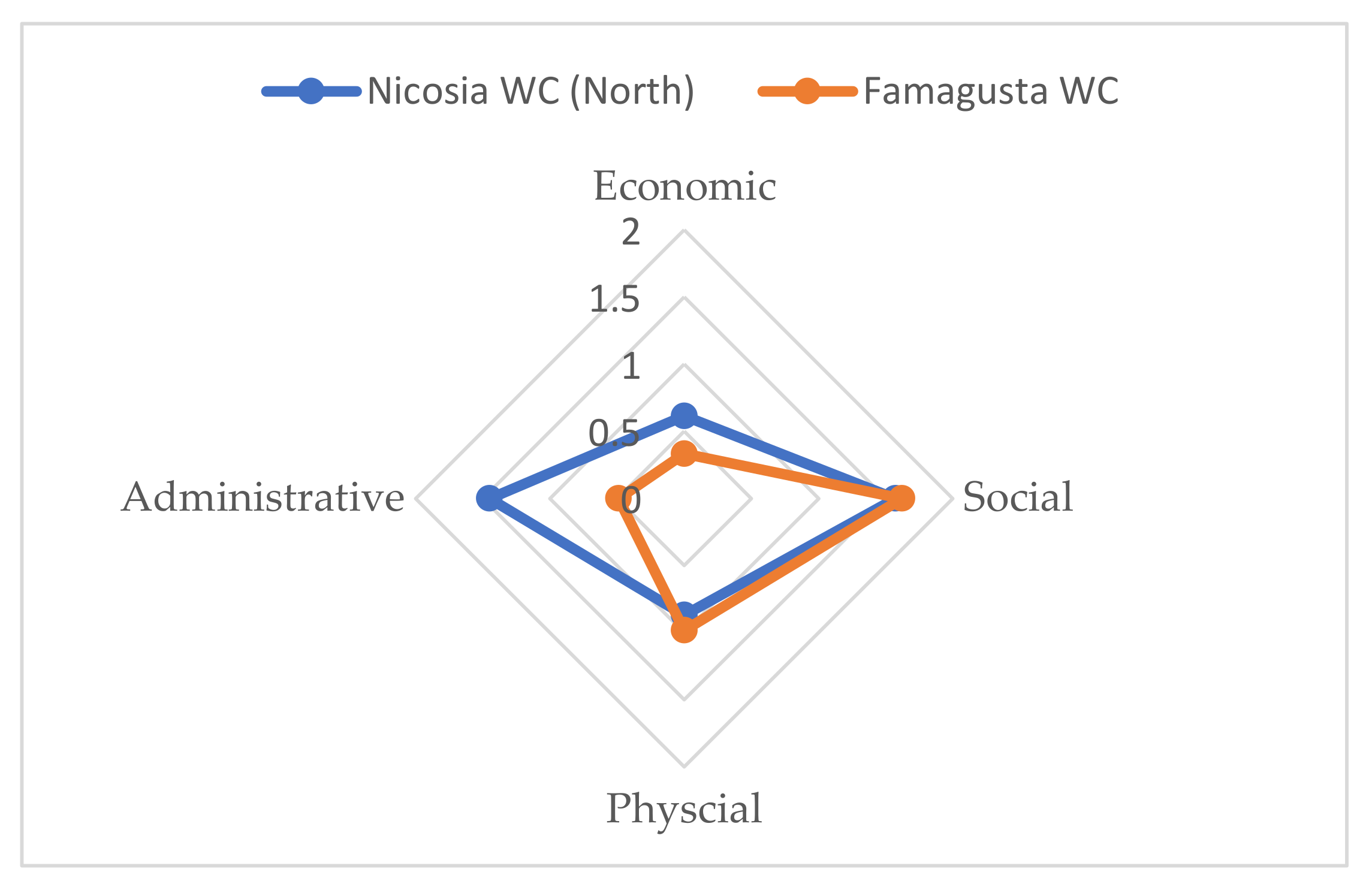
4. Discussion and Conclusion

In this study, urban renovation in historical and cultural heritage areas was evaluated within the scope of the sustainable urban development goal and targets. First, the SDG-11 target and sub-targets were examined, and a list of criteria for these objectives was created corresponding to the relative circumstances of the two case studies. The weights of these criteria have been demonstrated by experts using the AHP method. After the determination of relative weights, all criteria were analyzed, and the values found were normalized in the range of 0–1. After this stage, all data related to the Nicosia Walled City and Famagusta Walled City regions were collected, and the basic criteria and sub-criteria for sustainability were compared with criteria weights.
The United Nations’ sustainable development goals, even when explored individually, are highly complex and interconnected concepts. Contextual preferences add an extra layer of complexity to projects aiming for tangible progress toward the SDGs. This is more apparent in urban regeneration plans, which are highly contextual and correspond to different layers of local populations and stakeholders [86]. Complexity is an intrinsic quality of cities [87], which makes approaching Goal 11—sustainable cities and communities—that includes a multitude of criteria more challenging. What is more, the data associated with different dimensions of an urban regeneration project can come from a multitude of sources. Superimposing these data layers requires methodological innovations and interdisciplinary explorations. Thus, decision-making encapsulates these challenges, requiring a method that can address different criteria at once. AHP was used in this study to highlight a methodological possibility for addressing these complexities with regard to multiple data sources while hearing the voices of local experts. What is more, the involvement of stakeholders in regeneration plans is essential to moving toward the SDGs [20], and AHP can provide a framework for different voices to be heard. Future studies can further explore the comparison of criteria weights generated by the different parties involved. This is critical as the image of neighborhood regeneration can differ from the viewpoint of local communities and governing bodies [88]. The current method aims not to remain merely top-down or bottom-up; rather, it aims to utilize both. What is more, the diversity of supporting data sources makes the approach more comprehensive. In this case, the outcome did not merely reflect the point of view of experts, the department of antiquities, or the municipalities, for instance, but rather a combination of them.
The experts, in this case, evaluated economic, social, and environmental criteria as almost equally important, followed by the administrative criterion. The weighting of sub-criteria was a much more complicated process consisting of a multitude of data layers from different sources in two cases. The results show that each city has unique strengths and shortcomings in its regeneration approach when aiming for SDG-11. Northern Nicosia scores higher in most sub-criteria because it has a clear master plan, some neighborhood regeneration projects, better road safety, affordable housing, and pedestrianization schemes. This might be attributed to the centrality of the city, its population, and the flow of capital through it, which makes many of these projects feasible in the eyes of stakeholders. Famagusta, on the other hand, only excels in terms of the amount of green or open space per capita. In general, walkability and accessibility seem to be highly influential dimensions of sustainable regeneration efforts.
The importance of proper planning for land use in a growing, conflicted city is a concern. In both cases, the Cyprus conflict has left its mark, slowing regeneration efforts and especially international investments. Making a meaningful connection with the tourism sector by highlighting local culture and contextual values in the regeneration plan would make Nicosia’s regeneration plans more resilient [89]. Within the context of Nicosia, Atun [48] argues that regeneration plans should be a link between the past and future of the city. As one of the rare communal efforts between the north and south sides, these urban master plans could serve to create a more sustainable future for the cities. Savvides [90] shows the critical importance of accounting for residential and housing rehabilitation within the framework of the regeneration of Nicosia. In a regeneration plan, the housing sector is the seed for improving the economy and local job market. Although the administrative criterion was evaluated lower than the main pillars of suitability, it encapsulates and guides those criteria if conducted properly. It could be argued that the reason why Northern Nicosia scores higher across sub-criteria concerning SDG-11 is its masterplan, which is lacking in the case of Famagusta.
One of the current study’s findings was the apparent lack of attention paid to urban residential tissue when compared to well-known historic buildings. Affordable and socially inclusive housing is an essential component of sustainable urban regeneration planning and policies [91]. Thus, regeneration efforts targeting long-term sustainability need to pay closer attention to the residential tissue that is associated with the everyday life of the city. This is particularly important as both sites are points of interest for UNDP, so it could be argued that a more comprehensive approach that does not solely focus on the physical restoration of structures needs to be implemented. Furthermore, it cannot be denied that economic issues are the most central in terms of immediate impact on sustainable urban regeneration plans [92]; therefore, the micro-economy that empowers local production, involvement, and investigation is critical. This is critical as lack of attention to the local population can lead to displacement (intentional, incremental, or as a side effect of the economic transformation), transformation of the social fabric, and gentrification in some cases; these are well-known phenomena that occur when the planning parties are disconnected from the setting [88,93]. Therefore, the involvement of the local communities in the decision-making process is critical in achieving more sustainable and resilient future neighborhoods that aim for regeneration without displacement [93]. In this regard, AHP provides a methodological possibility for the involvement of different parties together with various secondary data sources.
In the end, it must be noted that this study was not without limitations. Many dimensions such as cultural heritage, social neighborhood structures, place attachment, and identity are influential elements of planning for urban regeneration [94], which are not investigated in this paper. Nevertheless, the methodological novelty of the study indicates the possibility of creating more inclusive and complex AHP models. Accordingly, future studies are required to expand on the list of criteria and to include other SDGs in the model.

Author Contributions

Conceptualization, C.K. and A.I.; methodology, C.K. and A.I.; software, C.K.; validation, C.K.; formal analysis, C.K.; investigation, C.K. and A.I.; resources, C.K.; data curation, C.K.; writing—original draft preparation, A.I. and C.K.; visualization, C.K.; supervision, C.K.; All authors have read and agreed to the published version of the manuscript.

Funding

This research received no external funding.

Data Availability Statement

Data can be made available upon reasonable request.

Acknowledgments

The authors would like to thank Famagusta and Nicosia Municipalities, Police Department R&D Branch, Antiquities and Town Planning.

Conflicts of Interest

The authors declare no conflict of interest.

References

  1. UN-Habitat. World Cities Report 2016: Urbanization and Development–Emerging Futures; UN-Habitat: Nairobi, Kenya, 2016. [Google Scholar]
  2. UN-Habitat. World Cities Report 2020: The value of Sustainable Urbanization; United Nations: Nairobi, Kenya, 2020. [Google Scholar]
  3. United-Nations. Transforming Our World: The 2030 Agenda for Sustainable Development. Available online: https://sdgs.un.org/2030agenda (accessed on 10 August 2022).
  4. Delle Cave, G. European development goals: Sustainable cities and public regeneration perspectives. DPCE Online 2021, 46, apr. 2021. [Google Scholar]
  5. Lucchi, E.; Buda, A. Urban green rating systems: Insights for balancing sustainable principles and heritage conservation for neighbourhood and cities renovation planning. Renew. Sustain. Energy Rev. 2022, 161, 112324. [Google Scholar] [CrossRef]
  6. Costanza, R.; Daly, L.; Fioramonti, L.; Giovannini, E.; Kubiszewski, I.; Mortensen, L.F.; Pickett, K.E.; Ragnarsdottir, K.V.; De Vogli, R.; Wilkinson, R. Modelling and measuring sustainable wellbeing in connection with the UN Sustainable Development Goals. Ecol. Econ. 2016, 130, 350–355. [Google Scholar] [CrossRef]
  7. Lu, Y.; Nakicenovic, N.; Visbeck, M.; Stevance, A.-S. Policy: Five priorities for the UN Sustainable Development Goals. Nature 2015, 520, 432–433. [Google Scholar] [CrossRef] [Green Version]
  8. Schuetze, T.; Gohaud, E. Potential for sustainable urban regeneration policies and practices in Daegu, Republic of Korea. IOP Conf. Ser. Earth Environ. Sci. 2020, 588, 052039. [Google Scholar] [CrossRef]
  9. Pontrandolfi, P.; Scorza, F. Sustainable Urban Regeneration Policy Making: Inclusive Participation Practice. In Proceedings of the Computational Science and Its Applications—ICCSA 2016, Beijing, China, 4–7 July 2016; pp. 552–560. [Google Scholar]
  10. Borges, L.A.; Adolphson, M. The role of official heritage in regional spaces. Urban Res. Pract. 2016, 9, 290–310. [Google Scholar] [CrossRef]
  11. Valencia, S.C.; Simon, D.; Croese, S.; Nordqvist, J.; Oloko, M.; Sharma, T.; Taylor Buck, N.; Versace, I. Adapting the Sustainable Development Goals and the New Urban Agenda to the city level: Initial reflections from a comparative research project. Int. J. Urban Sustain. Dev. 2019, 11, 4–23. [Google Scholar] [CrossRef] [Green Version]
  12. Deakin, M. A Community-Based Approach to Sustainable Urban Regeneration. J. Urban Technol. 2009, 16, 91–112. [Google Scholar] [CrossRef]
  13. Tiwari, G.; Chauhan, S.S.; Varma, R. Challenges of localizing sustainable development goals in small cities: Research to action. IATSS Res. 2021, 45, 3–11. [Google Scholar] [CrossRef]
  14. McDonald, S.; Malys, N.; Maliene, V. Urban regeneration for sustainable communities: A case study. Ukio Technol. Ir Ekon. Vystym. 2009, 15, 49–59. [Google Scholar] [CrossRef] [Green Version]
  15. Orozco-Messana, J.; Iborra-Lucas, M.; Calabuig-Moreno, R. Neighbourhood Modelling for Urban Sustainability Assessment. Sustainability 2021, 13, 4654. [Google Scholar] [CrossRef]
  16. Klopp, J.M.; Petretta, D.L. The urban sustainable development goal: Indicators, complexity and the politics of measuring cities. Cities 2017, 63, 92–97. [Google Scholar] [CrossRef]
  17. Wang, H.; Zhao, Y.; Gao, X.; Gao, B. Collaborative decision-making for urban regeneration: A literature review and bibliometric analysis. Land Use Policy 2021, 107, 105479. [Google Scholar] [CrossRef]
  18. Della Spina, L.; Giorno, C. Waste Landscape: Urban Regeneration Process for Shared Scenarios. Sustainability 2022, 14, 2880. [Google Scholar] [CrossRef]
  19. Natividade-Jesus, E.; Almeida, A.; Sousa, N.; Coutinho-Rodrigues, J. A Case Study Driven Integrated Methodology to Support Sustainable Urban Regeneration Planning and Management. Sustainability 2019, 11, 4129. [Google Scholar] [CrossRef] [Green Version]
  20. Marta, B.; Giulia, D. Addressing Social Sustainability in Urban Regeneration Processes. An Application of the Social Multi-Criteria Evaluation. Sustainability 2020, 12, 7579. [Google Scholar] [CrossRef]
  21. Hemphill, L.; McGreal, S.; Berry, J. An aggregated weighting system for evaluating sustainable urban regeneration. J. Prop. Res. 2002, 19, 353–373. [Google Scholar] [CrossRef]
  22. Arslan, T.V.; Durak, S.; Aytac, D.O. Attaining SDG11: Can sustainability assessment tools be used for improved transformation of neighbourhoods in historic city centers? Nat. Resour. Forum 2016, 40, 180–202. [Google Scholar] [CrossRef]
  23. Herrera-Limones, R.; LopezDeAsiain, M.; Borrallo-Jiménez, M.; Torres García, M. Tools for the Implementation of the Sustainable Development Goals in the Design of an Urban Environmental and Healthy Proposal. A Case Study. Sustainability 2021, 13, 6431. [Google Scholar] [CrossRef]
  24. Franco, L.A.; Montibeller, G. Problem Structuring for Multicriteria Decision Analysis Interventions. In Wiley Encyclopedia of Operations Research and Management Science; Wiley: Hoboken, NJ, USA, 2011. [Google Scholar] [CrossRef]
  25. Saaty, T.L. How to make a decision: The analytic hierarchy process. Eur. J. Oper. Res. 1990, 48, 9–26. [Google Scholar] [CrossRef]
  26. Saaty, T.L. Multicriteria Decision Making: The Analytic Hierarchy Process: Planning, Priority Setting Resource Allocation, 2nd ed.; RWS Publications: Pittsburgh, PA, USA, 1990. [Google Scholar]
  27. Carver, S.J. Integrating multi-criteria evaluation with geographical information systems. Int. J. Geogr. Inf. Syst. 1991, 5, 321–339. [Google Scholar] [CrossRef] [Green Version]
  28. Kara, C.; Doratli, N. Application of GIS/AHP in siting sanitary landfill: A case study in Northern Cyprus. Waste Manag. Res. 2012, 30, 966–980. [Google Scholar] [CrossRef]
  29. Kara, C.; Doratlı, N. Predict and Simulate Sustainable Urban Growth by Using GIS and MCE Based CA. Case of Famagusta in Northern Cyprus. Sustainability 2021, 13, 4446. [Google Scholar] [CrossRef]
  30. Manupati, V.K.; Ramkumar, M.; Samanta, D. A multi-criteria decision making approach for the urban renewal in Southern India. Sustain. Cities Soc. 2018, 42, 471–481. [Google Scholar] [CrossRef]
  31. Morano, P.; Locurcio, M.; Tajani, F.; Guarini, M.R. Fuzzy logic and coherence control in multi-criteria evaluation of urban redevelopment projects. Int. J. Bus. Intell. Data Min. 2015, 10, 73–93. [Google Scholar] [CrossRef]
  32. Nesticò, A.; Sica, F. The sustainability of urban renewal projects: A model for economic multi-criteria analysis. J. Prop. Invest. Financ. 2017, 35, 397–409. [Google Scholar] [CrossRef]
  33. Claver, J.; García-Domínguez, A.; Sebastián, M.A. Decision-making methodologies for reuse of industrial assets. Complexity 2018, 2018, 4070496. [Google Scholar] [CrossRef] [Green Version]
  34. Ribera, F.; Nesticò, A.; Cucco, P.; Maselli, G. A multicriteria approach to identify the Highest and Best Use for historical buildings. J. Cult. Herit. 2020, 41, 166–177. [Google Scholar] [CrossRef]
  35. Vehbi, B.O.; Günçe, K.; Iranmanesh, A. Multi-Criteria Assessment for Defining Compatible New Use: Old Administrative Hospital, Kyrenia, Cyprus. Sustainability 2021, 13, 1922. [Google Scholar] [CrossRef]
  36. Munier, N.; Hontoria, E. Uses and Limitations of the AHP Method, A Non-Mathematical and Rational Analysis; Springer: Cham, Switzerland, 2021. [Google Scholar] [CrossRef]
  37. Das, S. Flood susceptibility mapping of the Western Ghat coastal belt using multi-source geospatial data and analytical hierarchy process (AHP). Remote Sens. Appl. Soc. Environ. 2020, 20, 100379. [Google Scholar] [CrossRef]
  38. Omidipoor, M.; Jelokhani-Niaraki, M.; Moeinmehr, A.; Sadeghi-Niaraki, A.; Choi, S.-M. A GIS-based decision support system for facilitating participatory urban renewal process. Land Use Policy 2019, 88, 104150. [Google Scholar] [CrossRef]
  39. Wang, H.; Shen, Q.; Tang, B.-s.; Skitmore, M. An integrated approach to supporting land-use decisions in site redevelopment for urban renewal in Hong Kong. Habitat Int. 2013, 38, 70–80. [Google Scholar] [CrossRef] [Green Version]
  40. Podvezko, V. Application of AHP technique. J. Bus. Econ. Manag. 2009, 10, 181–189. [Google Scholar] [CrossRef] [Green Version]
  41. Bozorg-Haddad, O.; Zolghadr-Asli, B.; Loaiciga, H.A. A Handbook on Multi-Attribute Decision-Making Methods; John Wiley & Sons: Hoboken, NJ, USA, 2021. [Google Scholar]
  42. Zahedi, F. The Analytic Hierarchy Process—A Survey of the Method and its Applications. Interfaces 1986, 16, 96–108. [Google Scholar] [CrossRef]
  43. Saaty, T.L. A scaling method for priorities in hierarchical structures. J. Math. Psychol. 1977, 15, 234–281. [Google Scholar] [CrossRef]
  44. Doratli, N.; Hoskar, S.Ö.; Vehbi, B.O.; Fasli, M. Revitalizing a Declining Historic Urban Quarter—The Walled City of Famagusta, North Cyprus. J. Archit. Plan. Res. 2007, 24, 65–88. [Google Scholar]
  45. Iranmanesh, A.; Mousavi, S.A. Insights from the relationship between urban form, social media, and edu-tourism. Curr. Issues Tour. 2022, 1–16. [Google Scholar] [CrossRef]
  46. Iranmanesh, A.; Atun, R.A. Reading the Urban Socio-spatial Network through Space Syntax and Geo-tagged Twitter Data. J. Urban Des. 2020, 25, 738–757. [Google Scholar] [CrossRef]
  47. Vehbi, B.O.; Hoşkara, Ş.Ö. A Model for Measuring the Sustainability Level of Historic Urban Quarters. Eur. Plan. Stud. 2009, 17, 715–739. [Google Scholar] [CrossRef]
  48. Atun, R. Reconceptualising urban development in exceptional territories: Nicosia. WIT Trans. Ecol. Environ. 2012, 155, 365–375. [Google Scholar] [CrossRef]
  49. Demetriades, L. The Nicosia master plan. J. Mediterr. Stud. 1998, 8, 169–176. [Google Scholar]
  50. Bakshi, A.; Bjorkdal, A.; Strombom, L. Nicosia master plan, planning across the divide. In Divided Cities: Governing Diversity; Strömbom, L., Björkdahl, A., Eds.; Nordic Academic Press: Falun, Sweden, 2015; p. 197. [Google Scholar]
  51. Abu-Orf, H. Collaborative planning in practice: The Nicosia master plan. Plan. Pract. Res. 2005, 20, 41–58. [Google Scholar] [CrossRef]
  52. Tsolaki, A.; Trombadore, A.; Santamouris, M. Sustainable Master Planning and Urban Design for the “Buffer Zone” of Nicosia. In Proceedings of the 2nd PALENC Coference and 28th AIVC Conference, Crete, Greece, 5–6 October 2022. [Google Scholar]
  53. Russo, R.d.F.S.M.; Camanho, R. Criteria in AHP: A Systematic Review of Literature. Procedia Comput. Sci. 2015, 55, 1123–1132. [Google Scholar] [CrossRef] [Green Version]
  54. Kutut, V.; Zavadskas, E.; Lazauskas, M. Assessment of priority alternatives for preservation of historic buildings using model based on ARAS and AHP methods. Arch. Civ. Mech. Eng. 2014, 14, 287–294. [Google Scholar] [CrossRef]
  55. Lee, J.H.; Lim, S. An Analytic Hierarchy Process (AHP) Approach for Sustainable Assessment of Economy-Based and Community-Based Urban Regeneration: The Case of South Korea. Sustainability 2018, 10, 4456. [Google Scholar]
  56. Shehada, Z.M.; Ahmad, Y.B.; Yaacob, N.M.; Keumala, N.I. Developing methodology for adaptive re-use: Case study of heritage buildings in Palestine. ArchNet-IJAR Int. J. Archit. Res. 2015, 9, 216. [Google Scholar] [CrossRef]
  57. Yung, E.H.K.; Sun, Y. Power relationships and coalitions in urban renewal and heritage conservation: The Nga Tsin Wai Village in Hong Kong. Land Use Policy 2020, 99, 104811. [Google Scholar] [CrossRef]
  58. Zhuang, T.; Qian, Q.K.; Visscher, H.J.; Elsinga, M.G. Stakeholders’ Expectations in Urban Renewal Projects in China: A Key Step towards Sustainability. Sustainability 2017, 9, 1640. [Google Scholar] [CrossRef] [Green Version]
  59. De Renzio, P.; Masud, H. Measuring and Promoting Budget Transparency: The Open Budget Index as a Research and Advocacy Tool. Governance 2011, 24, 607–616. [Google Scholar] [CrossRef]
  60. Munda, G. Social multi-criteria evaluation: Methodological foundations and operational consequences. Eur. J. Oper. Res. 2004, 158, 662–677. [Google Scholar] [CrossRef]
  61. Yorucu, V.; Mehmet, O.; Alpar, R.; Ulucay, P. Cross-Border Trade Liberalization: The Case of Lokmaci/Ledra Gate in Divided Nicosia, Cyprus. Eur. Plan. Stud. 2010, 18, 1749–1764. [Google Scholar] [CrossRef]
  62. Mason, R.; Tumer, E.U.; Ünlü, A.K. WMF. The Walled City of Famagusta: A Framework for Urban Conservation and Regeneration; World Monuments Fund: New York, NY, USA, 2012. [Google Scholar]
  63. Pellicelli, G.; Caselli, B.; Garau, C.; Torrisi, V.; Rossetti, S. Sustainable Mobility and Accessibility to Essential Services. An Assessment of the San Benedetto Neighbourhood in Cagliari (Italy). In Proceedings of the Computational Science and Its Applications—ICCSA 2022 Workshops, Malaga, Spain, 4–7 July 2022; pp. 423–438. [Google Scholar]
  64. Gil Solá, A.; Vilhelmson, B.; Larsson, A. Understanding sustainable accessibility in urban planning: Themes of consensus, themes of tension. J. Transp. Geogr. 2018, 70, 1–10. [Google Scholar] [CrossRef]
  65. Moroke, T.; Schoeman, C.; Schoeman, I. Developing a neighbourhood sustainability assessment model: An approach to sustainable urban development. Sustain. Cities Soc. 2019, 48, 101433. [Google Scholar] [CrossRef]
  66. Hillier, B. Studying Cities to Learn about Minds: Some Possible Implications of Space Syntax for Spatial Cognition. Environ. Plan. B: Plan. Des. 2012, 39, 12–32. [Google Scholar] [CrossRef]
  67. Murray, A.T.; Davis, R.; Stimson, R.J.; Ferreira, L. Public Transportation Access. Transp. Res. Part D Transp. Environ. 1998, 3, 319–328. [Google Scholar] [CrossRef] [Green Version]
  68. Kaszczyszyn, P.; Sypion-Dutkowska, N. Walking Access to Public Transportation Stops for City Residents. A Comparison of Methods. Sustainability 2019, 11, 3758. [Google Scholar] [CrossRef] [Green Version]
  69. Teunissen, T.; Sarmiento, O.; Zuidgeest, M.; Brussel, M. Mapping Equality in Access: The Case of Bogotá’s Sustainable Transportation Initiatives. Int. J. Sustain. Transp. 2015, 9, 457–467. [Google Scholar] [CrossRef]
  70. Iranmanesh, A.; Mousavi, S.A. City and campus: Exploring the distribution of socio-spatial activities of students of higher education institutes during the global pandemic. Cities 2022, 128, 103813. [Google Scholar] [CrossRef]
  71. Litman, T.; Burwell, D. Issues in sustainable transportation. Int. J. Glob. Environ. Issues 2006, 6, 331–347. [Google Scholar] [CrossRef]
  72. Thogersen, J. Social Marketing of Alternative Transportation Modes. In Threats from Car Traffic to the Quality of Urban Life; Gärling, T., Steg, L., Eds.; Emerald Group Publishing Limited: West Yorkshire, UK, 2007; pp. 367–381. [Google Scholar]
  73. La Rosa, D.; Privitera, R.; Barbarossa, L.; La Greca, P. Assessing spatial benefits of urban regeneration programs in a highly vulnerable urban context: A case study in Catania, Italy. Landsc. Urban Plan. 2017, 157, 180–192. [Google Scholar] [CrossRef]
  74. Abubakar, A.M.; Shneikat, B.H.T.; Oday, A. Motivational factors for educational tourism: A case study in Northern Cyprus. Tour. Manag. Perspect. 2014, 11, 58–62. [Google Scholar] [CrossRef]
  75. Anser, M.K.; Yousaf, Z.; Nassani, A.A.; Alotaibi, S.M.; Kabbani, A.; Zaman, K. Dynamic linkages between poverty, inequality, crime, and social expenditures in a panel of 16 countries: Two-step GMM estimates. J. Econ. Struct. 2020, 9, 43. [Google Scholar] [CrossRef]
  76. Hancock, L. Community, Crime and Disorder: Safety and Regeneration in Urban Neighbourhoods; Palgrave Macmillan: London, UK, 2001. [Google Scholar] [CrossRef]
  77. Hull, A. Neighbourhood renewal: A toolkit for regeneration. GeoJournal 2000, 51, 301–310. [Google Scholar] [CrossRef]
  78. Alonso, J.M.; Andrews, R.; Jorda, V. Do neighbourhood renewal programs reduce crime rates? Evidence from England. J. Urban Econ. 2019, 110, 51–69. [Google Scholar] [CrossRef]
  79. De Sousa Silva, C.; Viegas, I.; Panagopoulos, Τ.; Bell, S. Environmental Justice in Accessibility to Green Infrastructure in Two European Cities. Land 2018, 7, 134. [Google Scholar] [CrossRef] [Green Version]
  80. Elvik, R.; Vaa, T.; Hoye, A.; Sorensen, M. The Handbook of Road Safety Measures; Emerald Group Publishing: Bingley, UK, 2009. [Google Scholar]
  81. Pellicelli, G.; Rossetti, S.; Caselli, B.; Zazzi, M. Urban regeneration as an opportunity to redesign Sustainable Mobility. Experiences from the Emilia-Romagna Regional Call. Transp. Res. Procedia 2022, 60, 576–583. [Google Scholar] [CrossRef]
  82. Appleyard, D. Livable Streets: Protected Neighborhoods? ANNALS Am. Acad. Political Soc. Sci. 1980, 451, 106–117. [Google Scholar] [CrossRef]
  83. Yao, Y.; Wang, X.; Lu, L.; Liu, C.; Wu, Q.; Ren, H.; Yang, S.; Sun, R.; Luo, L.; Wu, K. Proportionated Distributions in Spatiotemporal Structure of the World Cultural Heritage Sites: Analysis and Countermeasures. Sustainability 2021, 13, 2148. [Google Scholar] [CrossRef]
  84. Wang, X.; Ren, H.; Wang, P.; Yang, R.; Luo, L.; Cheng, F. A Preliminary Study on Target 11.4 for UN Sustainable Development Goals. Int. J. Geoheritage Park. 2018, 6, 18–24. [Google Scholar] [CrossRef]
  85. Korkmaz, C.; Balaban, O. Sustainability of urban regeneration in Turkey: Assessing the performance of the North Ankara Urban Regeneration Project. Habitat Int. 2020, 95, 102081. [Google Scholar] [CrossRef]
  86. Pirlone, F.; Spadaro, I.; Sabattini, M.; Nicola, M.D. Sustainable urban regeneration in port-cities. A participatory project for Genoa waterfront. TeMA J. Land Use Mobil. Environ. 2022, 15, 89–110. [Google Scholar] [CrossRef]
  87. Jacobs, J. The Death and Life of Great American Cities; Random House: New York, NY, USA, 1961; 458p. [Google Scholar]
  88. Chen, H.; Wang, L.; Waley, P. The Right to Envision the City? The Emerging Vision Conflicts in Redeveloping Historic Nanjing, China. Urban Aff. Rev. 2020, 56, 1746–1778. [Google Scholar] [CrossRef]
  89. Gronau, W.; Constanti, P. Urban Rehabilitation a Promising Opportunity for Product Enhancement in Tourism Industry? A Case Study from Nicosia/Cyprus. Int. J. Manag. Cases 2008, 10, 436–444. [Google Scholar] [CrossRef]
  90. Savvides, A.L. Housing Rehabilitation as a Means of Urban Regeneration and Population Integration. Int. J. Humanit. Soc. Sci. 2012, 6, 1749–1752. [Google Scholar] [CrossRef]
  91. Winston, N. Urban Regeneration for Sustainable Development: The Role of Sustainable Housing? Eur. Plan. Stud. 2009, 17, 1781–1796. [Google Scholar] [CrossRef]
  92. Couch, C.; Dennemann, A. Urban regeneration and sustainable development in Britain: The example of the Liverpool Ropewalks Partnership. Cities 2000, 17, 137–147. [Google Scholar] [CrossRef]
  93. Geva, Y.; Rosen, G. A win-win situation? Urban regeneration and the paradox of homeowner displacement. Environ. Plan. A Econ. Space 2022, 54, 67–83. [Google Scholar] [CrossRef]
  94. Aguiar Borges, L.; Hammami, F.; Wangel, J. Reviewing Neighborhood Sustainability Assessment Tools through Critical Heritage Studies. Sustainability 2020, 12, 1605. [Google Scholar] [CrossRef]
Figure 1. United Nations’ Sustainable Development Goals.
Land 12 00072 g001
Figure 2. The framework of the paper.
Land 12 00072 g002
Figure 3. The city and walled city of Famagusta (a); The city and walled city of Nicosia (b).
Land 12 00072 g003
Figure 4. Hierarchy for Sustainable Urban Regeneration for Historic Urban Quarters.
Land 12 00072 g004
Figure 5. Accessibility to Schools in Nicosia (a) and Famagusta (b) Walled Cities.
Land 12 00072 g005
Figure 6. Accessibility to Bus Stops in Nicosia (a) and Famagusta (b) Walled Cities.
Land 12 00072 g006
Figure 7. Accessibility to Green Space in Nicosia (a) and Famagusta (b) Walled Cities.
Land 12 00072 g007
Figure 8. Comparison of Main Criteria Results for the case areas.
Land 12 00072 g008
Table 1. Comparison and weight results for the selected criteria set.
Main-CriteriaWeightCRSub-CriteriaWeightCR
(A)
Economic
0.290.01Amount of investments that support amenities (T1)0.1900.02
Amount of investment for neighborhoods regeneration (T4)0.185
Affordable Housing (amount of housing prices or rents) (T1)0.273
Number of projects for supporting local production (T1)0.352
(B)
Social
0.26Proximity to basic services, distance to shopping areas, distance to school (T1).0.1620.02
Access to public transportation routes or bus stops (sustainable transportation) (T2)0.221
Regeneration projects that support alternative transportation modes (T2)0.208
Crime Rate Per Capita in Historic Urban Quarters0.131
Proximity to Green Space (T7)0.118
Percentage of Children Access to Green (T7)0.160
(C)
Environmental
0.30Percentage of Road Safety Projects or amount of area for traffic calming (T2)0.0940.01
Percentage of Shared Streets or Pedestrianized Streets (T2)0.087
Percentage of neighborhoods or quarters regenerated (T4)0.100
Percentage of building re-constructed (T4)0.072
Percentage of landmarks that were reconstructed (T4)0.060
Number of losses caused by flood events or different disasters (T5)0.120
Existing waste collection services (T6)0.163
Air Quality? (T6)0.101
Amount of area in industrial services/total area(T6)0.061
Amount of Greenspace per capita (T7)0.140
(D)
Administrative Legal
0.15Existing Master Plans or Protection Plans for the Historical Area (T3)0.3670
Design Guidelines that Support Protection Plans (T3)0.340
Existence of Protection Urban Master plans with Regional Plans (T8)0.293
Table 2. Crime Analysis in Nicosia and Famagusta Walled Cities.
NicosiaFamagusta
YearsPopulationAmountRatioPopulationAmountRatio
201168002980.04147630.00
201268153430.05147220.00
201368353210.05146290.01
201468882740.041459320.02
201569562110.031459330.02
201669502160.031443590.04
201769582040.031430350.02
201870872360.031442580.04
201971812620.041447220.02
202071522150.031427310.02
OVERALL0.04 0.02
Table 3. Evaluation of the Criteria and Sub-Criteria for the case areas.
Criteria/Case AreaNicosia Walled City (North)Famagusta Walled CityResources
EconomicAmount of investments that support amenities (T1)0.1310.059Authors: Open Street Map
Amount of investment for neighborhoods regeneration (T4)0.690.31UNDP, Municipalities Antiquities Dept.
Affordable Housing (amount of housing prices or rents) (T1)0.1550.118Authors: local real estate services
Number of projects for supporting local production (T1)0.2110.141Authors: Open Street Maps
SocialProximity to basic services, distance to shopping areas, distance to school, distance to (T1)0.7570.787Authors: GIS
Access to public transportation routes or bus stops (sustainable transportation) (T2)0.5270.45Authors: GIS
Regeneration projects that support alternative transportation modes (T2)00UNDP, Municipalities Antiquities Dept.
Number of Crime/Crime Rate Per Capita in Historic Urban Quarters (2011-2020)0.040.02Police Dept.
Proximity to Green Space (T7) 0.7670.889Authors: GIS
Percentage of Children Access to Green (T7)0.7670.889Authors: GIS
Environmental/PhysicalNumber of Road Safety Projects or amount of area for traffic calming (T2)0.500.25UNDP, Municipalities Antiquities Dept.
Percentage of Shared Streets or Pedestrianized Streets (T2)0.130.07UNDP, Municipalities
Percentage of neighborhoods or quarters regenerated (T4)0.210.03UNDP, Municipalities Antiquities Dept.
Percentage of building(listed) reconstructed (T4)--UNDP, Municipalities Antiquities Dept.
Percentage of landmarks that were reconstructed (T4)0.280.25UNDP, Municipalities Antiquities Dept.
Number of losses caused by flood events or different disasters (T5)00Municipalities
Existing waste collection services (T6)0.750.77Municipalities, LIPA (2019)
Air Quality? (T6)--Environment Dept.
Ratio of industrial services to total area(T6)0.030.01Town Planning
Amount of Greenspace per capita (T7)0.18 0.90Authors: GIS
AdministrativeExisting Master Plans or Protection Plans for the Historical Area (T3)10Town Planning
Design Guidelines that Support Protection Plans or Policies (T3)11Town Planning
Existence of Protection Urban Master plans with Regional Plans (T8)10Town Planning
Disclaimer/Publisher’s Note: The statements, opinions and data contained in all publications are solely those of the individual author(s) and contributor(s) and not of MDPI and/or the editor(s). MDPI and/or the editor(s) disclaim responsibility for any injury to people or property resulting from any ideas, methods, instructions or products referred to in the content.

